44


FINAL—Archaeological Monitoring and Data Recovery Plan
for Sewer System Evaluation Survey (SSES) Based System
Improvements – GWA Route 4 Relief Sewerline Rehabilitation
and Replacement Project, Hagåtña and Sinajana
Municipalities, Guam
Prepared For:
AECOM
414 W. Soledad Avenue, Suite 708
Hagåtña, Guam 96910
Prepared By:
Cacilie E. Craft, MA, RPA
Garcia and Associates
Garden Villa, H-302
800 Pale San Vitores Road
Tamuning, Guam 96913
GANDA Report No. 2363-1
25 October 2016


i
ABSTRACT
At the request of AECOM, Garcia and Associates has prepared this
Archaeological Monitoring and Data Recovery Plan (AMDRP) to guide archaeological
monitoring for the GWA Route 4 Relief Sewerline Rehabilitation and Replacement
Project in Hagåtña and Sinajana Municipalities on the island of Guam. This sewerline
project is part of Sewer System Evaluation Survey (SSES) Based System
Improvements, a Section 106 undertaking funded through Drinking Water and Clean
Water SRF grant funds administered by the Unites States Environmental Protection
Agency (EPA). The AMDRP presents methods and protocols that will be followed
during archaeological investigations for the undertaking as well as environmental,
historical, and archaeological background information necessary to generate
monitoring expectations.

ii

iii
CONTENTS
ABSTRACT ................................................................................................................. I
FIGURES .................................................................................................................. IV
TABLE ..................................................................................................................... IV
1.0 INTRODUCTION .................................................................................................. 1
1.1 Nature of the Undertaking ............................................................................ 1
1.1.1 Area of Potential Effect .......................................................................... 1
2.0 BACKGROUND ................................................................................................... 4
2.1 Environmental Context ................................................................................. 4
2.2 Occupational History .................................................................................... 6
2.2.1 Pre-Latte Period (1500 BCE–500 CE) and Transitional (500–800 CE) 6
2.2.2 Latte Period (800–1521 CE) ................................................................... 6
2.2.3 Pre-Colonial European Trade Period (1521–1668 CE) .......................... 7
2.2.4 Spanish Missionization / Colonial Period (1668–1898) ......................... 7
2.2.5 First American Territorial Period (1898–1941) ...................................... 9
2.2.6 World War II / Japanese Military Occupation Period (1941–1944) .... 10
2.2.6.1 Battle of Guam ............................................................................... 11
2.2.7 Second American Territorial Period (1944–1950) ............................... 13
2.2.8 Organic Act / Economic Development Period (1950–Present) ............ 13
2.3 Archaeological Context .............................................................................. 14
2.3.1 Coastal Archaeological Investigations ................................................. 18
2.3.2 Inland Archaeological Investigations ................................................... 18
2.3.3 Archaeological Expectations ................................................................ 20
3.0 PROJECT DESIGN ............................................................................................. 20
3.1 Ground Disturbing Activities ...................................................................... 21
3.1.1 Design Phase......................................................................................... 21
3.1.2 Construction Phase ............................................................................... 21
3.1.3 Archaeological Probability Model........................................................ 22
3.2 Archaeological Monitoring Design ............................................................. 22
3.2.1 Documentation of Monitoring Activities ............................................. 23
3.2.2 Sampling Strategies .............................................................................. 23
3.2.3 Stratigraphic Documentation ................................................................ 24
3.3 Inadvertent Discovery ................................................................................. 24
3.3.1 Data Recovery ...................................................................................... 24
iv
3.4 Post-Fieldwork Actions ............................................................................... 25
3.4.1 Laboratory Analysis .............................................................................. 25
3.4.1.1 Flotation .......................................................................................... 25
3.4.1.2 Radiocarbon Samples ..................................................................... 25
3.4.1.3 Ceramic Analysis ........................................................................... 26
3.4.1.4 Faunal Analysis .............................................................................. 26
3.4.1.5 Formal Artifacts ............................................................................. 26
3.4.1.6 Lithic Analysis ............................................................................... 26
3.4.2 Curation ................................................................................................ 27
3.4.3 Final Report .......................................................................................... 27
4.0 REFERENCES .................................................................................................... 28
APPENDIX A: .......................................................................................................... 31
FIGURES
Figure 1. Project location on the island of Guam and within the Western Pacific. . 2
Figure 2. Location of APE and anticipated excavation areas. ................................. 3
Figure 3. Documented soils within the APE. .......................................................... 5
Figure 4. Seventeenth-century Spanish map of Guam. ........................................... 8
Figure 5. Garcia’s 1881 map of the city of Hagåtña. .............................................. 9
Figure 6. The city of Hagåtña in the early-1900s. ................................................. 10
Figure 7. 1914 map of Hagåtña. ............................................................................ 11
Figure 8. U.S. objectives for 31 July 1944. ........................................................... 12
Figure 9. Oblique 1949 aerial view of Hagåtña. ................................................... 14
Figure 10. Previous archaeology conducted in vicinity of APE, Map 1 of 2. ....... 16
Figure 11. Previous archaeology conducted in vicinity of APE, Map 2 of 2. ....... 17
Figure 12. Burial concentrations encountered during SWCA investigations. ....... 19
TABLE
Table 1. Previous Archaeological Studies in Project Vicinity .............................. 15

1
1.0 INTRODUCTION
At the request of AECOM, Garcia and Associates has prepared this
Archaeological Monitoring and Data Recovery Plan (AMDRP) to guide archaeological
investigations for the GWA Route 4 Relief Sewerline Rehabilitation and Replacement
Project in Hagåtña and Sinajana, Guam. This project is part of Sewer System
Evaluation Survey (SSES) Based System Improvements, a Section 106 undertaking
funded by Drinking Water and Clean Water SRF grant funds administered by the U.S.
Environmental Protection Agency (EPA). The objective of archaeological work will
be to identify, record, sample, analyze, and catalog any historic properties that may be
exposed during the undertaking. Archaeological investigations for the project will
comply with federal cultural resource law, including Section 106 of the National
Historic Preservation Act of 1966, as amended, all applicable Guam Public Laws and
Executive Orders, and the methods and procedures outlined in this AMDRP.
1.1 Nature of the Undertaking
The objective of the undertaking is to rehabilitate and potentially replace portions
of an existing relief sewer pipeline on West Soledad Avenue, Route 1, and Route 4 in
Hagåtña and Sinajana (Figure 1). The relief sewer pipeline was installed in the 1990s
and runs parallel to the main sewer pipeline, but was never “placed in service and has
remained inactive due to poor or incomplete construction” (GWA 2015:17). In order
to help alleviate the amount of flow through the main pipeline, the current project aims
to “bring the inactive relief sewer line into service through rehabilitation, repair, or
replacement” (GWA 2015:17). Approximately 2,286 linear meters (7,500 linear feet)
of pipe along Route 4, Route 1, and West Soledad Avenue will be evaluated during the
Project to determine the level of improvements needed. The majority of planned
improvements include rehabilitating sewer lines by cured-in-place pipe (CIPP) lining
methods to minimize the amount of trench excavation. However, some sewer pipe
sections will require replacement and new construction by conventional open-cut
trenching. Subsurface ground disturbance associated with the undertaking will
therefore involve trench excavation to repair existing pipe or construct new sections of
pipe.
1.1.1 Area of Potential Effect
The undertaking’s Area of Potential Effect (APE) comprises 2,286 linear meters
(7,500 linear feet) of existing relief sewerline beneath Route 4, Route 1, and West
Soledad Avenue in Hagåtña and Sinajana, Guam (Figure 2). This relief sewer pipeline
begins at the top of the hill on Route 4 in Sinajana and continues to the intersection of
Route 4 and Route 1 in Hagåtña, where it connects through West Soledad Avenue to
the main sewer pipeline on Route 1 in front of Chamorro Village. The APE includes

2
Figure 1. Project location on the island of Guam and within the Western Pacific.

3
Figure 2. Location of APE and anticipated excavation areas within Hagåtña and Sinajana
Municipalities.

4
the entire width of the Route 1 and Route 4 roadways, totaling 7.25 hectares (17.91
acres). Currently, ground-disturbing activities are only anticipated along portions of
the APE where excavations to replace or construct new sections of pipeline are
expected (Figure 2; also see Section 3.1 for a full description of ground disturbing
activities).
2.0 BACKGROUND
This section presents background information and archaeological expectations for
the project. This includes summaries of the physical environment, history, and previous
archaeological studies as they relate to the project area and its direct vicinity.
2.1 Environmental Context
Guam sits about 13 degrees north of the equator and has a tropical marine climate.
The island’s wet and dry seasons are defined by changes in rainfall, temperature, and
wind patterns. In the wet season, from July to November, annual rainfall averages 216
to 292 cm (Gingerich 2003:1). Guam has historically experienced frequent tropical
storms and typhoons due to its position in the western typhoon trough. Typhoons bring
large amounts of rainfall and strong winds that can devastate local vegetation,
infrastructure, and historic properties.
Geologically, the project area is comprised of Quaternary beach deposits
composed of beach sand and gravel with some detrital limestone (Tracey et al. 1964).
Soils throughout most of the project area are characterized by Young (1988:59) as
nearly level Urban Land-Ustorthents Complex due to the high volume of landscape
modification in Hagåtña (Figure 3). This soil series consists of areas covered by roads
(such as the current APE), parking lots, and buildings with Ustorthents of quarried fill
material (e.g., crushed limestone gravel). The soil series is indicative of large-scale
landscape modifications in the region as a result of the destruction sustained during
World War II and subsequent modern development. However, intact Shioya Loamy
Sand is still encountered in some areas of the coastal strand below modern construction
fill (Walth 2015; Young 1988:52). As the APE travels uphill, it reaches Pulantat Clay,
30 to 60 percent slope, a shallow and well-drained soil that forms in dissected plateaus
and hills (Young 1988:43). Soil depth is typically 30 cm to weathered limestone. The
terminal southern end of the APE is characterized by Pulantat-Urban Land, comprised
of half Pulantat Clay and half Urban Land on the nearly level upland limestone plateau
overlooking Hagåtña (Young 1988:48).

5
Figure 3. Documented soils within the APE.

6
2.2 Occupational History
Guam’s occupational history can be divided into pre-Contact and Historic eras.
The pre-Contact era encompasses indigenous settlement during the Pre-Latte,
Transitional, and Latte Periods. Guam’s Historic era is characterized by increasing
outside influence on the island and is divided into the Spanish Missionization/Colonial,
First American Territorial, World War II Japanese Military Occupation, Post World
War II/Second American Territorial Period, and Organic Act/Economic Development
Periods (GHRD 2014). These divisions are used to structure the following sections.
2.2.1 Pre-Latte Period (1500 BCE–500 CE) and Transitional Period (500–800
CE)
The Pre-Latte Period, extending from 1500 BCE to 500 CE, can be divided into
the Early (1500–1000 BCE), Middle (1000–500 BCE), and Late (500 BCE–500 CE)
Pre-Latte Periods (GHRD 2014). This era includes the initial settlement of Guam and
the Mariana Islands. Archaeological evidence indicates that the island’s early settlers
favored resource-rich coastal environments where they exploited reef flats for fish and
shellfish. Investigations conducted by Cordy and Allen (1986) indicate that the back
beach berm below the Agaña cliff line was occupied by about 600 BCE with the lower
and middle Agaña marshlands not yet filled in by this time. Habitation sites during the
Pre-Latte Period probably consisted of small, nucleated groups of stilt houses near the
early shoreline as well as caves and rockshelters in the Agaña cliff line useful for storm
protection (Russell 1998:90–91). The Transitional Period (500–800 CE) is marked by
an expansion from coastal sites to the island’s interior likely for exploitation of natural
resources and fresh water.
2.2.2 Latte Period (800–1521 CE)
The Latte Period (800–1521 CE) is differentiated from earlier periods largely by
the appearance of stone foundation structures called latte. The period can be further
divided into the Early (800–1100 CE), Middle (1100–1350 CE), and Late (1350–1521
CE) Latte Periods (GHRD 2014). Latte Period sites reflect island-wide land use and
settlement, as well as an increase in population that expanded to exploit fresh water
sources on the northern limestone plateau and southern river valleys. Cordy and Allen
(1986:203) describe the period from 1300–1600 CE as a time of great settlement
expansion and land use in the Hagåtña region with at least four recorded coastal
villages (Fonte, Anigua, Agaña, and Apurguan) and three inland villages (Sinajana,
Chochogo, and Mapaz). Surviving Latte Period sites were documented by Hornbostel
in the 1920s (n.d.; Thompson 1932). Artifact and pottery scatters as well as subsurface
archaeological deposits documented in the greater Agaña Marsh area attest to a range
7
of settlement activity in the centuries prior to the arrival of Europeans (Cordy and Allen
1986; Pangelinan 1984).
2.2.3 Pre-Colonial European Trade Period (1521–1668 CE)
When the Magellan expedition landed in Guam in 1521, it propelled the
indigenous population into contact with the European world, ushering in the Pre-
Colonial European Trade Period (1521–1668 CE). Soon thereafter, Spanish Galleons
routinely anchored in Guam to trade for fresh provisions before completing their
journey to the Philippines from Acapulco, Mexico. Spain did not formally
acknowledge colonial possession of the Mariana Island chain until 1565.
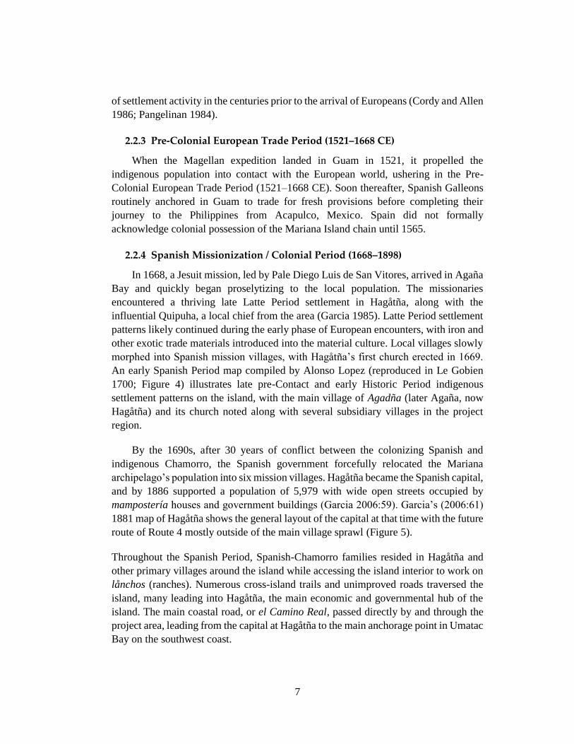
2.2.4 Spanish Missionization / Colonial Period (1668–1898)
In 1668, a Jesuit mission, led by Pale Diego Luis de San Vitores, arrived in Agaña
Bay and quickly began proselytizing to the local population. The missionaries
encountered a thriving late Latte Period settlement in Hagåtña, along with the
influential Quipuha, a local chief from the area (Garcia 1985). Latte Period settlement
patterns likely continued during the early phase of European encounters, with iron and
other exotic trade materials introduced into the material culture. Local villages slowly
morphed into Spanish mission villages, with Hagåtña’s first church erected in 1669.
An early Spanish Period map compiled by Alonso Lopez (reproduced in Le Gobien
1700; Figure 4) illustrates late pre-Contact and early Historic Period indigenous
settlement patterns on the island, with the main village of Agadña (later Agaña, now
Hagåtña) and its church noted along with several subsidiary villages in the project
region.
By the 1690s, after 30 years of conflict between the colonizing Spanish and
indigenous Chamorro, the Spanish government forcefully relocated the Mariana
archipelago’s population into six mission villages. Hagåtña became the Spanish capital,
and by 1886 supported a population of 5,979 with wide open streets occupied by
mampostería houses and government buildings (Garcia 2006:59). Garcia’s (2006:61)
1881 map of Hagåtña shows the general layout of the capital at that time with the future
route of Route 4 mostly outside of the main village sprawl (Figure 5).
Throughout the Spanish Period, Spanish-Chamorro families resided in Hagåtña and
other primary villages around the island while accessing the island interior to work on
lånchos (ranches). Numerous cross-island trails and unimproved roads traversed the
island, many leading into Hagåtña, the main economic and governmental hub of the
island. The main coastal road, or el Camino Real, passed directly by and through the
project area, leading from the capital at Hagåtña to the main anchorage point in Umatac
Bay on the southwest coast.

8
Figure 4. Seventeenth-century Spanish map of Guam designating village names and locations
(Le Gobien 1700).

9
Figure 5. Garcia’s 1881 map of the city of Hagåtña (from Garcia 2006:62–63).
2.2.5 First American Territorial Period (1898–1941)
In 1898, the United States secured Guam from Spain as a result of its success in
the Spanish-American War. The island was put under the jurisdiction of the U.S.
Department of the Navy and commanded like a battleship with over two dozen naval
officers acting as governors from 1903 until the Japanese occupation in December 1941
(Rogers 1995:119–120).
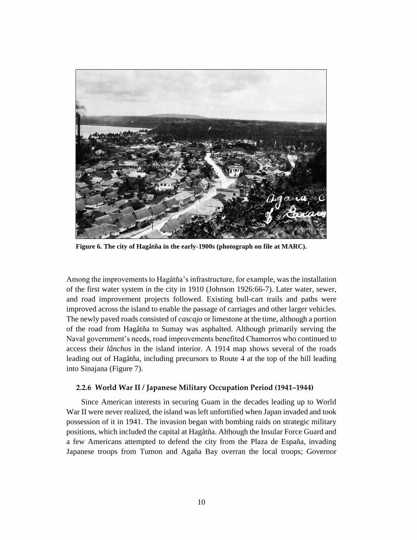
Hagåtña remained the capital of the island and supported the bulk of the island’s
population through the First American Territorial Period (1898–1941). A photograph
on file at the Micronesian Area Research Center illustrates urbanized Hagåtña in the
1900s (Figure 6). The rows of houses are similar to those from the previous Spanish
Period, which Garcia (2006:60) described at the time as “built of wood…[and] erected
on harigues, a meter or more above the ground.” Harigue is a local Philippine term for
house posts or pillars made of solid tree trunks (Garcia 2006:60).
The Spanish-Chamorro way of life largely persisted during the early twentieth
century, although infrastructure improvement projects modernized life for residents of
the island’s larger villages.
General
project area
10
Figure 6. The city of Hagåtña in the early-1900s (photograph on file at MARC).
Among the improvements to Hagåtña’s infrastructure, for example, was the installation
of the first water system in the city in 1910 (Johnson 1926:66-7). Later water, sewer,
and road improvement projects followed. Existing bull-cart trails and paths were
improved across the island to enable the passage of carriages and other larger vehicles.
The newly paved roads consisted of cascajo or limestone at the time, although a portion
of the road from Hagåtña to Sumay was asphalted. Although primarily serving the
Naval government’s needs, road improvements benefited Chamorros who continued to
access their lånchos in the island interior. A 1914 map shows several of the roads
leading out of Hagåtña, including precursors to Route 4 at the top of the hill leading
into Sinajana (Figure 7).
2.2.6 World War II / Japanese Military Occupation Period (1941–1944)
Since American interests in securing Guam in the decades leading up to World
War II were never realized, the island was left unfortified when Japan invaded and took
possession of it in 1941. The invasion began with bombing raids on strategic military
positions, which included the capital at Hagåtña. Although the Insular Force Guard and
a few Americans attempted to defend the city from the Plaza de España, invading
Japanese troops from Tumon and Agaña Bay overran the local troops; Governor

11
Figure 7. 1914 map of Hagåtña.
McMillin surrendered the island less than six hours after the invading troops had landed
(Rogers 1995:156).
Japanese forces, numbering almost 6,000, overtook the capital, including every
public building and many residences. (Rogers 1995:158). During the ensuing Japanese
Occupation Period (1941–1944), many Chamorros fled their main residences to
lånchos in the island interior in an attempt to avoid the occupiers. Throughout the
occupation, however, the Chamorro population was forced to toil in agricultural fields
to feed Japanese troops and in the construction of airfields and defensive positions,
often with inadequate tools and during long grueling hours. Japanese defensive
positions, constructed in part by Chamorro labor, dotted the island’s west coast. The
Hagåtña cliff line to the west of the study parcel was used for air raid shelters (GHPI
Site 66-01-1052), which were excavated into the limestone hillside and used as early
as 1944.
2.2.6.1 Battle of Guam
Prior to the land invasion of Guam, U.S. military forces bombed the west coast of
the island for a grueling 13 days, the longest pre-bombardment sustained by any Pacific

12
island during World War II. Following the heavy bombardment of Japanese coastal
defenses as well as several local villages, U.S. troops stormed Asan and Agat beaches
on Guam’s southwest coast on 21 July 1944. After heavy fighting at the beaches and
sustaining brutal counterattacks from the Japanese Imperial Army stationed in the hills,
American forces secured the Force Beachhead Line on 29 July 1944. On 31 July,
American forces pivoted to the northeast to pursue the retreating Japanese army onto
the northern plateau of the island. En route to their goal of reaching the O-1 line just
east of Hagåtña (Figure 8), the 3rd Battalion of the 3rd Marine Regiment, 3rd Marine
Division reached the main plaza of the city by 1045 on 31 July (Lodge 1954:124; Crowl
1993:383).
Figure 8. U.S. objectives for 31 July 1944, indicating location of O-1 Line east
of Hagåtña (from Lodge 1954).

13
Although casualties were reported from road mines navigating into the city, no
enemy resistance was reported once inside Hagåtña (Lodge 1954:124). There was little
left for Japanese forces to defend, since the city was largely destroyed. Hagåtña was
fully occupied by American forces by noon of that same day.
Following reconnaissance of the island’s northern plateau, General Geiger
announced the end of organized resistance on Guam on the 10th of August. The
remaining Japanese forces, numbering more than 9,000, were dispersed and
unorganized within the jungles of Guam, mostly in the northern interior.
Reconnaissance operations necessitated considerable search efforts by U.S. forces.
Small battles and confrontations occurred in the jungles, abandoned farms, and
dilapidated roads of the interior long after the island was declared secure.
2.2.7 Second American Territorial Period (1944–1950)
The U.S. military ramped up construction on Guam following the invasion and
recapture of the island. Large plots of land were acquired and bulldozed to
accommodate new airfields, depots, headquarters, and related facilities designed to
support the final mission against the Japanese homeland. One of the primary goals of
securing the Mariana Islands was fully realized with the construction of specialized
airfields to support the long-range, high-altitude B-29 Superfortress. Two of these new
airfields were constructed in northern Guam: North Field and Northwest Field (now
Andersen Air Force Base). Orote Peninsula and Apra Harbor were transformed into a
major forward operating U.S. Naval base. Support facilities sprung up around the
island. To improve accessibility to the various installations on island, Naval
Construction Battalions, or Seabees, bulldozed large networks of roads across the
island. The precursor to Route 1 was speedily bulldozed along the west coast, passing
through Agaña Bay. Route 4 was also improved to permit access for newly resettled
Sinajana residents, as shown in a 1949 aerial photograph of the capital (Figure 9).
With most of Hagåtña’s former residents displaced to post-war resettlement
villages, such as Sinajana to the south, the capital was left largely abandoned for a time.
The Navy’s intention was to rebuild the capital according to modern American cities,
but these plans were not enacted (Rogers 1995:186). Rubble from the war was cleared
into the mouth of the Agaña River (which was diverted) and the city was bulldozed.
2.2.8 Organic Act / Economic Development Period (1950–Present)
By 1955, the rubble that had been pushed to the mouth of the Agaña River was
made into a park, the Paseo de Susana (Rogers 1995:186). Residents had repopulated
the city by this time, but it was no longer the residential center of the island. Hagåtña
instead developed into one of the main commercial and administrative districts on the

14
Figure 9. Oblique 1949 aerial view of Hagåtña (photograph on file at Government
Maps and Documents Collection, University of Hawai‘i).
island with most of Guam’s residents living elsewhere and commuting into Hagåtña
for work. The main routes into the city, coastal Route 1 and inland Route 4, were paved
with asphalt. Underneath the asphalt, Route 1 and Route 4 support some of the city’s
main infrastructure for water, sewer, and communications systems.
2.3 Archaeological Context
Archaeological investigations conducted in the region prior to the extensive
destruction of World War II and subsequent modern development indicate pre-Contact
and Historic Period use of the Agaña floodplain. Hornbostel (n.d.), who conducted
island-wide investigations in the 1920s, noted sites with latte elements along the
eastern Agaña coastline. According to Thompson (1932:15), these sites included the
Latte Period Agaña and Apurguan coastal village sites. The results of more recent
archaeological investigations conducted in the last few decades help elucidate the
extent of post-World War II disturbance in the area and the potential for encountering
archaeological deposits that have been left intact. Eight recent studies conducted in the
vicinity of the APE are discussed in the sections below (Table 1; Figure 10 and Figure
11).
Route 4

15
Table 1. Previous Archaeological Studies in Project Vicinity
Reference Type of Archaeological
Investigation
Archaeological Findings
Hornbostel n.d. (Thompson
1932)
Island-wide survey Intact latte elements along
Hagåtña coastline
Amesbury et al. 1991 Monitoring and Data
Recovery
17 pre-Contact burials
Cordy and Allen 1986 Inventory survey and
subsurface testing
Latte Period pottery
scatters
Olmo 1995 Subsurface testing Mixed historical deposits
Yee 2010 and 2011 Monitoring None
Carson and Peterson 2010 Subsurface testing None
Walth 2015 Monitoring and Data
Recovery
Intact cultural deposits
with 3 concentrations of
pre-Contact burials
DeFant 2016 Monitoring None
Liston 2016 Monitoring Stratified cultural deposits
in a possible tidal zone

16
Figure 10. Previous archaeology conducted in vicinity of APE, Map 1 of 2.
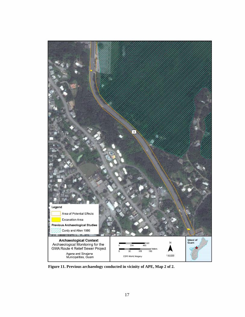
17
Figure 11. Previous archaeology conducted in vicinity of APE, Map 2 of 2.

18
2.3.1 Coastal Archaeological Investigations
Despite the intensity of ground disturbance along the Hagåtña coastline in the last
75 years, buried components of Latte Period settlements have been documented, most
notably underneath Route 1. While monitoring for road construction projects,
Amesbury et al. (1991) and Walth (2015) recorded intact archaeological deposits and
clusters of pre-Contact burials (Figure 10). Amesbury et al. (1991) documented 17
burial features and scatters of human skeletal elements in beach sand below modern
road fill on the coastal side of the Route 1/Route 8 intersection (GHPI Site 66-01-
0261). Charcoal associated with the burials yielded radiocarbon dates ranging from AD
770 to 1410, or within the Latte Period. Walth’s (2015) investigations at the Agaña
Bridge also revealed intact cultural deposits below Route 1 (Walth 2015). Sixty-five
burial features dating from the Latte Period to the early post-Contact Period were
encountered. The burials were largely confined to three concentrations located on the
west, central, and east sections of the Route 1 project area (Figure 12). Three general
strata were recorded for the project area: Stratum I, consisting of multiple sublayers of
crushed limestone and sandy clay fill; Stratum II, a 40 to 60 cm thick sand containing
human remains, faunal bone, pre-Contact pottery, lithics, shell, and historical artifacts;
and Stratum III, a culturally sterile beach sand. According to the monitoring report
(Walth 2015), the upper portion of the cultural layer (Stratum II) was truncated in some
areas by road construction in the 1950s. As a result, some cultural features were
encountered as shallow as 10 to 20 cm below the lowest base coarse layer.
DeFant (2016) also conducted archaeological investigations along Route 1 in front
of Chamorro Village (Figure 10), but these excavations remained relatively shallow
(from 30 to 60 cmbs) and contained entirely within crushed limestone and clay fill
sediments. No cultural material was encountered.
Liston’s (2016) recent study for the Festival of the Pacific Arts huts at Paseo Loop
(on the coastal side of Route 1) posits that the pre-World War II shoreline was located
on or close to the southern arc of the recently constructed Festival huts (Figure 10). A
truncated cultural deposit containing scattered human skeletal remains and historic
artifacts in what appeared to be a tidal zone was encountered at 50 cmbs. The author
also noted a deeper (110 cmbs) light gray stained sand that was void of artifacts or
midden remains, but that may be the periphery of a pre-Contact deposit that extends
inland toward Route 1.
2.3.2 Inland Archaeological Investigations
Archaeological investigations conducted further inland from the Hagåtña coastline
attest to the limits of encountering intact subsurface cultural deposits along the inland,
Route 4 portions of the APE (Figure 10 and Figure 11). Olmo (1994) documented “a

19
Figure 12. Burial concentrations encountered during SWCA investigations for the Hagåtña Bridge (from Walth 2015:208).
20
mechanically disturbed deposit containing debris” associated with the pre- and post-
World War II Periods on the west side of Route 4. No intact cultural deposition was
documented, but a basalt lusong (mortar stone) was recorded in the basal sand layer of
a backhoe test trench. Other recent archaeological investigations include those
conducted by Yee (2010 and 2011) at the Nieves B. Flores Memorial Library on the
west side of the Route 1/Route 7a intersection and Carson and Peterson (2010) at the
Nanbo Insurance Building on the east side of the Route 1/Route 7a intersection. These
studies documented a lack of intact soil strata in the project vicinity. Both
investigations encountered modern rubbish mixed with mechanically introduced
sediment.
Cordy and Allen (1986) investigated a larger area even further inland, within the
Hagåtña marsh (Figure 10 and Figure 11). The authors posited that the lower and
middle Agaña marshlands would not have been filled in by the pre-Latte or Transitional
Periods, but that Latte Period artifact scatters with subsurface pottery and midden
indicated temporary use of the hummocks within the marsh during the later pre-Contact
Period.
2.3.3 Archaeological Expectations
Subsurface activity in the APE is expected to expose multiple layers of post-World
War II fill and modern base coarse. Excavations along Route 1 have the highest
potential to encounter intact cultural deposits, which may be present in Shioya sand
below modern road fill (Walth 2015; Amesbury et al. 1991). In contrast, recent
archaeological investigations conducted on either side of Route 4 in the heart of
Hagåtña have exposed either mixed Historic Period deposits disturbed by post-World
War II earth moving events (Olmo 1995) or a complete lack of subsurface cultural
deposition (Yee 2010 and 2011; Carson and Peterson 2010). As the APE travels upland
along Route 4, archaeological potential diminishes even further. Although no
archaeological studies appear to have been conducted in the direct vicinity of the
southern extent of the APE, any archaeological deposits that may have been present in
the shallow Pulantat clay soil were likely removed during road and sewerline
construction.
3.0 PROJECT DESIGN
The following section describes the anticipated scope of ground disturbing
activities associated with the GWA Route 4 Relief Sewerline Rehabilitation and
Replacement Project and details the project-specific methods and protocols to be
utilized during archaeological monitoring.

21
3.1 Ground Disturbing Activities
The undertaking involves various long-term improvements to the existing
wastewater collection system in Hagåtña, including the sewer infrastructure along
West Soledad Avenue, Route 1, and Route 4. Ground-disturbing activities associated
with these improvements will occur in two phases, as described below.
3.1.1 Design Phase
A series of test borings will be conducted within the APE to perform a soils
investigation. The objective of the investigation is to provide geotechnical
recommendations for the design and construction of the sewerline project. Four, 8-inch
soil borings will be drilled using a mobile drill hollow stem auger (see Figure 10 for
locations). Split spoon samplers will be used to extract soil samples at approximate 5
feet intervals.
3.1.2 Construction Phase
Improvements during the construction phase include new sewer pipe construction,
replacement of existing sewer pipe, and rehabilitation of existing sewer pipe. The
majority of the planned improvements include rehabilitating sewer lines by CIPP lining
methods to minimize the amount of trench excavation. However, some sewer pipe
sections will require replacement and new construction by conventional open cut
trenching. Subsurface ground disturbance during the construction phase will therefore
involve trench excavation to repair existing pipe or construct new sections of pipe.
Currently, anticipated excavation dimensions for the project include (Figure 2;
Appendix A):
Thirty-six (36) linear meters to repair existing pipe on Route 1 in
front of Chamorro Village;
One hundred seventy (170) linear meters to construct new pipe
along West Soledad Avenue;
One hundred seventy (170) linear meters to repair existing pipe
along Route 4 through Hagåtña; and
Two (2), 5 to 10-meter-long trenches to repair existing pipe on
Route 4 in Sinajana.
Excavations on West Soledad Avenue and Route 1 are anticipated to require an
approximate 1 to 1.5 m wide by 3 to 4 m deep trench. Excavations along Route 4 are
expected to require 3 to 4 m wide trenches, varying in depth from 1.5 to 4.5 m below
the road surface.

22
Currently, excavations to construct new pipe are only expected along West
Soledad Avenue, commencing at the intersection of Route 1 and 4 and continuing past
the Bank of Guam Building (Figure 2). This sewerline trench will be excavated
adjacent to the existing relief sewer line but will potentially occur in undisturbed
sediment. All other planned excavations for the project on Route 1 and Route 4 are
expected to occur within previously excavated sewerline trenches.
It is important to note that during construction these excavation dimensions may
need to be altered to accommodate unknown conditions along the sewerline, changes
in design requirements for new pipe construction, conflicts with existing utilities, and
so on. Therefore, there may be a need to excavate and repair additional pipe segments
within the APE or modify the location and scope of new pipe construction.
3.1.3 Archaeological Probability Model
Based on the current construction scope, excavations to construct new pipe along
West Soledad Avenue have the highest potential to expose archaeological deposits.
Pipe construction will involve excavating an approximate 1 to 1.5 m wide by 3 to 4 m
deep trench alongside the existing relief sewer pipe in this area. Since these excavations
will occur adjacent to, rather than on top of, the existing sewerline, undisturbed
sediment may be exposed. Previous archaeological studies in the vicinity of Route 1
and West Soledad Avenue have exposed intact archaeological deposits with large
concentrations of human burials (Walth 2015; Amesbury et al. 1991). It remains to be
seen if these deposits continue into the current APE and to what extent they have been
impacted by previous utility and road construction.
It is anticipated that all other ground disturbance for the project will involve
digging to expose and repair existing segments of sewer pipe. These excavations will
therefore occur within previously excavated utility trenches and will have a low
potential to expose intact archaeological deposits. Any ground disturbance that takes
place further inland and up the hill of Route 4 will also have a low potential to expose
intact cultural deposits due to the shallow nature of inland soils in this area.
3.2 Archaeological Monitoring Design
Garcia and Associates will conduct full-time, on-site archaeological monitoring
for select ground-disturbing activities associated with the GWA Route 4 Relief
Sewerline Rehabilitation and Replacement Project. All excavation schedules will be
closely coordinated with the client and the construction crew to ensure that an
archaeological monitor is present. Prior to any ground-disturbance work, Garcia and
Associates’ supervisory archaeologist will brief all field personnel on procedures
regarding the inadvertent discovery of cultural and/or archaeological resources. This

23
will include a discussion of the archaeologist’s authority to temporarily halt project
activity if potential resources are encountered.
During the project’s design phase, GANDA will monitor four soil borings up to a
depth of 2.1 meters (7 feet) or the water table; monitoring for soil auguring will
therefore only be conducted for the top 2.1 meters (7 feet) and not the entire auguring
depth. The archaeological monitor will observe auger tailings during boring and will
inspect soil samples from split spoon samplers extracted at approximate depths of 0.60
meters (2 feet) and 2.1 meters (7 feet).
During the construction phase, GANDA will monitor excavation trenches and
back dirt for the presence of cultural deposits. The client and construction crew will
ensure that a flat-blade bucket is utilized for any trenching conducted in sand.
Archaeological monitoring will not be conducted for excavation that occurs within
asphalt or concrete and will only be conducted to a limited extent for excavation
occurring in modern road fill. Monitoring will also not be conducted for excavations
that take place below the water table or within bedrock.
3.2.1 Documentation of Monitoring Activities
All monitoring activities will be fully documented by the archaeological monitor
in daily log and photographic form. If cultural resources are encountered, their location
will be recorded with a hand-held Trimble GPS with sub-meter accuracy using UTM
Zone 55 North and the WGS 1984 datum (GPS data will be differentially corrected
post-fieldwork). Monitoring activities and any recovered material will be
photographically documented with a photo board and scale. Standards for
documentation and analysis of archaeological sites and materials will be in accordance
with the Secretary of the Interior’s Standards and Guidelines for Archaeological
Documentation.
3.2.2 Sampling Strategies
Sampling strategies will be employed to collect pertinent information on the nature
of intact features or deposits. If discrete, single-event features are encountered, they
will be exposed in planview to the extent possible. The feature will then be bisected
and mapped in profile. One half of the feature will be collected as a soil sample for
possible future analysis, while the other half will be screened through ¼-inch mesh.
Whenever possible, bulk samples (in 1 liter units) will also be collected from intact
anthropogenic layers, if encountered. Bulk samples will be screened through ¼-inch
mesh, as appropriate. Artifacts that are diagnostic of a time period or cultural affiliation
or that are unusual in nature will be collected for laboratory analysis. Artifacts observed

24
in trench sidewalls will be point provenienced before being collected, while artifacts
collected from spoils will be provenienced as appropriate.
3.2.3 Stratigraphic Documentation
Stratigraphic profiles and descriptions will be recorded for the following: 1) areas
with subsurface cultural features or deposits, 2) sampled areas, and 3) areas with a
sedimentary change or unconformity that contains information relevant to past human
events. Profiles will also be recorded in areas void of cultural deposits with the aim of
representing the general stratigraphy of the area. All stratigraphic data will be described
in accordance with current National Soil Survey Center and Munsell Color Notation
conventions. All profiles will be recorded with a Trimble GPS and photographically
documented with a photo board and scale.
3.3 Inadvertent Discovery
If significant archaeological deposits or human skeletal materials are inadvertently
discovered during archaeological monitoring, the project archaeologist will carefully
expose enough of the discovery to ascertain its condition. The resource will then be
stabilized, protected, clearly marked and all work will cease within a 10-meter radius.
The Guam Historic Resources Division (GHRD) will be immediately notified.
Consultation will then commence to determine the significance of the exposed resource
and to establish the nature and extent of any data recovery and/or preservation measures
to be implemented.
3.3.1 Data Recovery
Should data recovery excavations be required for inadvertent discovery of
significant archaeological deposits or human skeletal remains, controlled excavation
units will be placed within the APE in order to recover data relative to the age, nature,
cultural affiliation, integrity, and depositional history of encountered deposits. The
size, number, and placement of excavation units will be determined through
consultation with the client and GHRD. Controlled excavation will proceed in 10 cm
arbitrary levels within natural strata using shovels and trowels. Measurements and
elevations will be recorded using a meter tape and level. All excavated sediment will
be sieved using 1/8 and 1/4-inch mesh.
Excavations units will be documented using standardized forms and procedures
for recording stratigraphic profiles, plan view maps, and digital photographs. A
minimum of one face of each excavation unit will be stratigraphically profiled and
described in detail. Special samples (e.g., soil pollen, charcoal) will be retrieved if
deemed appropriate by supervisory personnel. Each major excavation unit or level and

25
all in situ cultural features will be digitally photographed. Plan view sketches will be
recorded at the base of major excavation units or when cultural features are exposed.
The location of excavation units will also be recorded with a sub-meter accurate
Trimble GPS.
3.4 Post-Fieldwork Actions
The nature and scope of post-fieldwork actions will vary according to the results
of fieldwork. The following subsections describe methods for laboratory analysis,
curation procedures, and reporting requirements for the project.
3.4.1 Laboratory Analysis
All cultural material recovered during fieldwork will be processed and analyzed.
Transportation of samples from the field to the laboratory will minimally include
proper labeling, minimization of handling, isolation of specific samples in appropriate
storage containers, and ensuring an adequately arid environment for radiocarbon and
soil samples.
All artifacts and midden samples will be thoroughly cleaned prior to analysis.
Artifacts will then be photographed, sketched, and identified. All metric attributes will
be recorded and presented in tabular form in the final report. Midden samples will be
identified to the lowest taxonomic level possible. A discussion of these finds in relation
to their archaeological context and inferred use will also be provided.
3.4.1.1 Flotation
If archaeological features are encountered, feature fill may be subjected to
flotation analysis. Flotation techniques are used to increase the quantity of cultural
remains recovered and provide additional knowledge of plant and animal use in an
archaeological context. Soil from features will be collected and poured into a sieve and
submerged into a container of water. The sieve will be agitated in the water, allowing
fine grained material to escape while lighter organic material floats to the surface.
These particles will then be gathered with a fine mesh and submitted for faunal and
botanical analysis.
3.4.1.2 Radiocarbon Samples
Should in situ archaeological features, such as hearths or cooking pits, be
encountered, carbonized remains will be collected and submitted for radiocarbon
dating. Prior to submission, all samples will be submitted for species identification.
Only short-lived species will be submitted for dating.

26
3.4.1.3 Ceramic Analysis
The goal of ceramic analysis is to generate data on form, function, and chronology
for the assemblage. The ceramic assemblage will be inspected for standard Mariana
analytical attributes to allow comparison with other Mariana assemblages. Pottery
sherds will be cleaned, sorted, counted, and weighed. Sherds will initially be sorted by
sherd type: diagnostic or undiagnostic. Undiagnostic pottery sherds are body sherds
that lack attributes related to a specific temporal period, function, or form. Diagnostic
sherds include rim sherds, decorated sherds, and sherds with distinctive morphological
features. Diagnostic sherds will be analyzed for the following attributes: temper type,
surface treatment, rim type, and morphological features.
Exterior surface treatment will be determined by inspecting each sherd and
classifying it according to the following types: plain, banded, boldly combed, faintly
combed, incised, striated, polished/burnished, slipped/washed, slipped, wiped/brushed,
lime-coated, lime-impressed, mat impressed, fabric/shell impressed, and eroded. For
each rim sherd, shape, rim thickness, and wall thickness will be recorded. When
possible, whole-vessel analysis will be performed. This will involve reconstruction of
articulating sherds or the presence of large rim sherds that display overall vessel form
and aperture size. Sherds with unique attributes, including surface treatment or
morphological features, will be photographed or illustrated. Profile drawings of a
representative sample of rims from the assemblage will be prepared.
3.4.1.4 Faunal Analysis
Any collected vertebrate or marine invertebrate material will be weighed, counted,
and taxonomically identified to the highest level of detail possible. Faunal and marine
shell analysis will be conducted using comparative collections. The final report will
discuss analytical methods employed, laboratory results, and descriptions of identified
species and their relationship to their environment and archaeological context.
3.4.1.5 Formal Artifacts
Formal artifacts will be measured, weighed, sketched or photographed, and
functionally classified as appropriate. If possible, artifact typologies will be used
according to currently accepted standards for pre-Contact and historic artifacts.
3.4.1.6 Lithic Analysis
Stone tools will be analyzed by form and inferred function. Typological affiliation
will conform to currently accepted typologies for pre-Contact and historic stone tools
on Guam and the Marianas Islands. Waste material from the manufacturing process
will be measured using metric and non-metric attributes. When possible, statistical

27
calculations will be made to summarize and describe the assemblage, as well as to
compare data to other collections.
3.4.2 Curation
All archaeological materials will be clearly labeled, catalogued, packed for long-
term archival storage, and temporarily curated at the Garcia and Associates’ Guam
laboratory before being transferred to the Guam Museum.
3.4.3 Final Report
Following completion of archaeological fieldwork, a technical report will be
prepared to include at a minimum: 1) abstract, 2) project overview, 3) background
research, 4) project methodology, and 5) discussion and analysis of results. Guam
Historic Properties Inventory (GHPI) site numbers will also be obtained and submitted
with GHPI Data Forms for each site. Final deliverables will include two hard copies
and one digital copy (PDF file and GIS shapefiles on CD) of the final approved report.

28
4.0 REFERENCES
Carson, M. and J. Peterson
2010 Archaeological Test Trench Findings in Support of Construction of the New
Nanbo Insurance Building. Prepared for Sumitomo Mitsui Construction Co.,
Ltd., Tokyo, Japan. Micronesian Area Research Center, University of Guam,
Mangilao, Guam.
Cordy, R. and J. Allen
1986 Archaeological Investigations of the Agaña and Fonte River Basins, Guam.
Prepared for the U.S. Army Engineer District, Fort Shafter, Hawai‘i. J. Stephen
Athens, Ph.D., Archaeological Consultant, Honolulu.
Crowl, P.A.
1993 Campaign in the Marianas. Center of Military History, United States Army,
Washington, D.C.
DeFant, D. G.
2016 End of Fieldwork Letter Report: Archaeological Monitoring, Route 1
Signalized Pedestrian Crossing at Chamorro Village Project, GU-NH-
0001(129), Hagåtña, Island of Guam. Prepared for U.S. Department of
Transportation Federal Highway Administration, Hawaii Federal-Aid Division,
Honolulu, Hawaiʻi. Prepared by Southeastern Archaeological Research Inc.,
Tamuning, Guam.
Garcia, F.
1985 The Life and Martyrdom of the Venerable Father Diego Luis de San
Vitores. Originally published in 31 parts as “First History of Guam,” Guam
Recorder 1936–1939. Partial translation by M. Higgins. Compiled Ms. on file,
Micronesian Area Research Center, University of Guam, Mangilao, Guam.
2006 The Mariana Islands, 1884–1887: Random Notes. Translated by M.G.
Driver. Micronesian Area Research Center, University of Guam, Mangilao,
Guam.
Gingerich, S.B.
2003 Hydrologic Resources of Guam. Water Resources Investigation Report 03-
4126. U.S. Geological Survey, Honolulu.
Guam Historic Resources Division (GHRD)
2014 Guam Historic Properties Inventory Data Form. Guam Department of
Parks and Recreation, Hagåtña, Guam.
Guam Waterworks Authority (GWA)
2015 Request for Proposals: Route 4 Relief Sewerline Rehabilitation and
Replacement, GWA Project No. S15-006-EPA. Prepared by Guam Waterworks
Authority, Mangilao, Guam.
Hornbostel, H.
n.d. Unpublished field notes, 1921–1924. Manuscript on file at Bernice Pauahi
Bishop Museum, Honolulu.

29
LeGobien, C.
1700 History of the Mariana Islands Newly Converted to the Christian Religion
and of the Glorious Death of the First Martyrs who Preached the Faith There.
Translated by Father P.V. Daly, C.P.S. (1949). Manuscript on file, Micronesian
Area Research Center, University of Guam, Mangilao, Guam.
Liston, J.
2016 Draft Report on Archaeological Monitoring of Construction Excavations for
Festival of the Pacific Huts, Paseo, Hagåtña, Guam. Prepared for RNK
Architects, Tamuning, Guam. International Archaeology, LLC, Tamuning,
Guam.
Lodge, R.
1954 The Recapture of Guam. U.S. Marine Corps Monograph Series, Historical
Branch G-3 Division Headquarters, U.S. Marine Corps, Fredericksburg, Texas.
Olmo, R.
1995 Archaeological Testing for the TOMEN Office Building, Agaña, Guam.
Prepared for Sumitomo Construction Co., Ltd. International Archaeological
Research Institute, Inc., Honolulu.
Rogers, R.F.
1995 Destiny’s Landfall: A History of Guam. University of Hawai‘i Press,
Honolulu.
Russell, S.
1998 Tiempon I Manmofo'na: Ancient Chamorro Culture and History of the
Northern Mariana Islands. Micronesian Archaeological Survey Report No. 32.
Division of Historic Preservation, Department of Community and Cultural
Affairs, Saipan, Commonwealth of the Northern Marianas.
Thompson, L.
1932 Archaeology of the Mariana Islands. Bulletin No. 100. Bernice P. Bishop
Museum, Honolulu.
Tracey, J., S. Schlanger, J. Stark, D. Doan, and H. May
1964 General Geology of Guam. Geological Survey Professional Paper 403-A,
Washington, D.C.
Walth, C.
2015 Draft – Archaeological Investigation for the Agaña Bridge #1 and Route
1/Route 8 Intersection Improvements, Hagåtña, Guam, Volume I. Prepared for
Guam Department of Public Works, Tamuning, Guam. Prepared by SWCA
Environmental Consultants, Tamuning, Guam.

30
Yee, S.
2010 Archaeological Monitoring at the Nieves B. Flores Memorial Library for
Cable Installation. Prepared for MCV Guam Holding Corp., Tamuning, Guam.
SWCA Environmental Consultants, Tamuning, Guam.
2011 Archaeological Monitoring of GPA Excavations for Line Replacement at the
Intersection of Route 4 and O'Brien Drive, Hagåtña, Guam. Prepared for Guam
Power Authority, Hagåtña, Guam. International Archaeological Research
Institute, Inc., Barrigada, Guam.
Young, F.J.
1988 Soil Survey of the Territory of Guam. United States Department of
Agriculture, Soil Conservation Service in cooperation with the Guam
Department of Commerce and the University of Guam. Washington, D.C.

31
APPENDIX A:
APPROXIMATE BOUNDARIES OF TRENCH EXCAVATION

GU
AM
WA
TE
RW
OR
KS
AU
TH
OR
IT
Y
RO
UT
E 4 R
ELIE
F S
EW
ER
LIN
E
RE
HA
BILIT
AT
IO
N A
ND
R
EP
LA
CE
ME
NT
GW
A P
RO
JE
CT
N
O. S
15-006-E
PA
FIG
UR
E 1
AP
PR
OX
IM
AT
E B
OU
ND
AR
Y O
F
TR
EN
CH
E
XC
AV
AT
IO
N - R
OU
TE
1
JU
LY
2016
N
TRENCH
EXCAVATION
SEWER MANHOLE
AND PIPE
LEGEND
GROUND ELEVATION

GU
AM
WA
TE
RW
OR
KS
AU
TH
OR
IT
Y
RO
UT
E 4 R
ELIE
F S
EW
ER
LIN
E
RE
HA
BILIT
AT
IO
N A
ND
R
EP
LA
CE
ME
NT
GW
A P
RO
JE
CT
N
O. S
15-006-E
PA
FIG
UR
E 2
AP
PR
OX
IM
AT
E B
OU
ND
AR
Y O
F
TR
EN
CH
E
XC
AV
AT
IO
N - R
OU
TE
4 - A
JU
LY
2016
N
TRENCH EXCAVATION
SEWER MANHOLE AND PIPE
LEGEND
GROUND ELEVATION
ST
A 35+
00 M
AT
CH
LIN
E S
EE
F
IG
UR
E 3

GU
AM
WA
TE
RW
OR
KS
AU
TH
OR
IT
Y
RO
UT
E 4 R
ELIE
F S
EW
ER
LIN
E
RE
HA
BILIT
AT
IO
N A
ND
R
EP
LA
CE
ME
NT
GW
A P
RO
JE
CT
N
O. S
15-006-E
PA
JU
LY
2016
N
FIG
UR
E 3
AP
PR
OX
IM
AT
E B
OU
ND
AR
Y O
F
TR
EN
CH
E
XC
AV
AT
IO
N - R
OU
TE
4 - B
TRENCH
EXCAVATION
SEWER MANHOLE
AND PIPE
LEGEND
GROUND ELEVATION
S
T
A
3
5
+
0
0
M
A
T
C
H
L
I
N
E
S
E
E
F
I
G
U
R
E
2


