62
© Crown copyright Met Office Weather and climate modelling workshop, INPE, Cachoeira Paulista Met Office Unified Model George Pankiewicz, December 2008
| Date post: | 13-Dec-2015 |
| Category: |
Documents |
| Upload: | laura-mitchell |
| View: | 215 times |
| Download: | 0 times |
© Crown copyright Met Office
Weather and climate modelling workshop, INPE, Cachoeira Paulista
Met Office Unified ModelGeorge Pankiewicz, December 2008
© Crown copyright Met Office
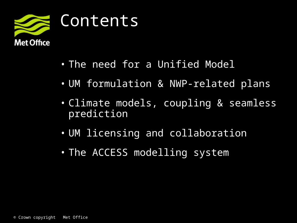
Contents
• The need for a Unified Model
• UM formulation & NWP-related plans
• Climate models, coupling & seamless prediction
• UM licensing and collaboration
• The ACCESS modelling system

© Crown copyright Met Office
The need for a Unified Model
© Crown copyright Met Office
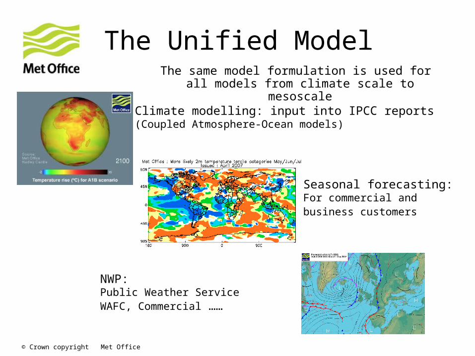
The same model formulation is used for all models from climate scale to mesoscale
The Unified Model
Climate modelling: input into IPCC reports(Coupled Atmosphere-Ocean models)
Seasonal forecasting:For commercial and business customers
NWP:Public Weather ServiceWAFC, Commercial ……
© Crown copyright Met Office
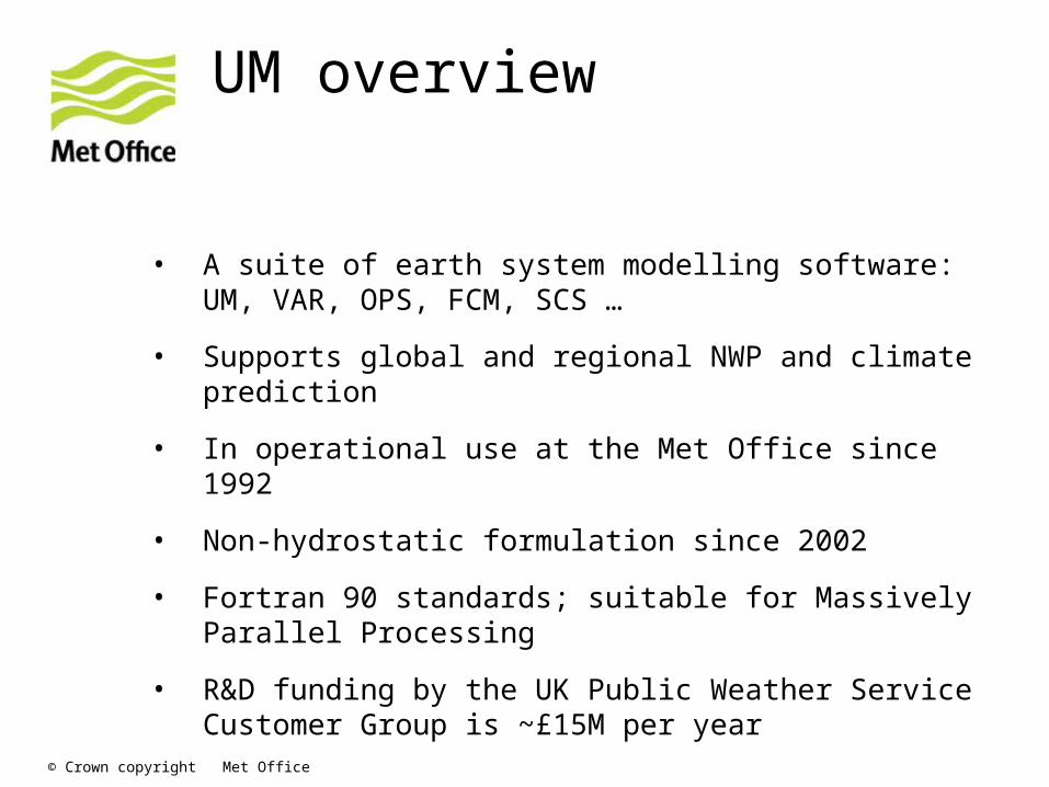
UM overview
• A suite of earth system modelling software: UM, VAR, OPS, FCM, SCS …
• Supports global and regional NWP and climate prediction
• In operational use at the Met Office since 1992
• Non-hydrostatic formulation since 2002
• Fortran 90 standards; suitable for Massively Parallel Processing
• R&D funding by the UK Public Weather Service Customer Group is ~£15M per year
© Crown copyright Met Office
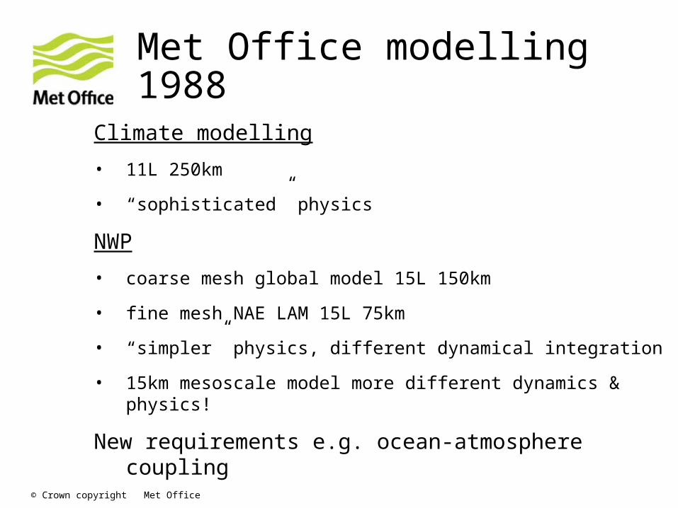
Met Office modelling 1988
Climate modelling
• 11L 250km
• “sophisticated” physics
NWP
• coarse mesh global model 15L 150km
• fine mesh NAE LAM 15L 75km
• “simpler” physics, different dynamical integration
• 15km mesoscale model more different dynamics & physics!
New requirements e.g. ocean-atmosphere coupling
© Crown copyright Met Office
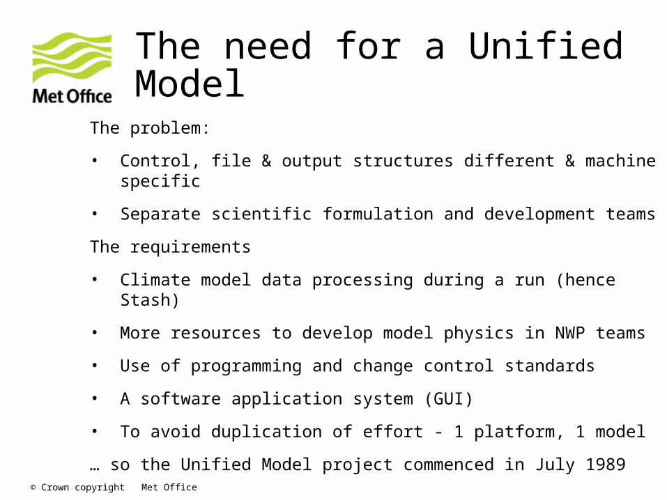
The need for a Unified Model
The problem:
• Control, file & output structures different & machine specific
• Separate scientific formulation and development teams
The requirements
• Climate model data processing during a run (hence Stash)
• More resources to develop model physics in NWP teams
• Use of programming and change control standards
• A software application system (GUI)
• To avoid duplication of effort - 1 platform, 1 model
… so the Unified Model project commenced in July 1989

© Crown copyright Met Office
UMUI input panel
© Crown copyright Met Office
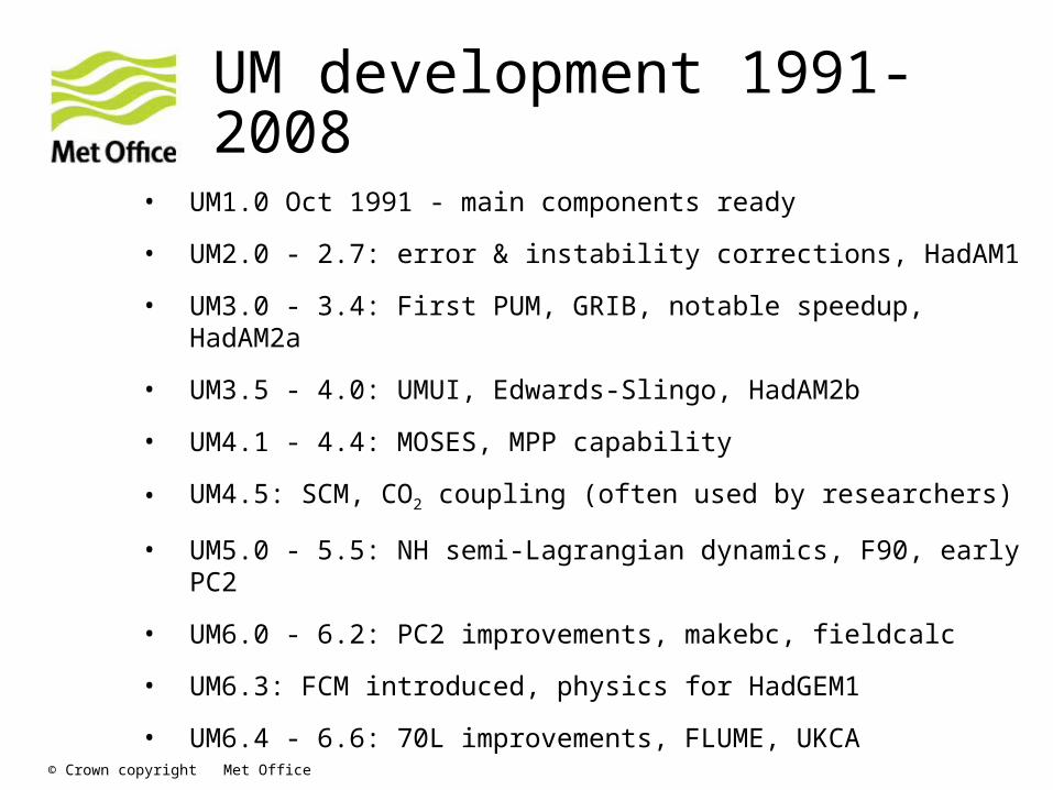
UM development 1991-2008
• UM1.0 Oct 1991 - main components ready
• UM2.0 - 2.7: error & instability corrections, HadAM1
• UM3.0 - 3.4: First PUM, GRIB, notable speedup, HadAM2a
• UM3.5 - 4.0: UMUI, Edwards-Slingo, HadAM2b
• UM4.1 - 4.4: MOSES, MPP capability
• UM4.5: SCM, CO2 coupling (often used by researchers)
• UM5.0 - 5.5: NH semi-Lagrangian dynamics, F90, early PC2
• UM6.0 - 6.2: PC2 improvements, makebc, fieldcalc
• UM6.3: FCM introduced, physics for HadGEM1
• UM6.4 - 6.6: 70L improvements, FLUME, UKCA

© Crown copyright Met Office
UM formulation & NWP-related plans
© Crown copyright Met Office
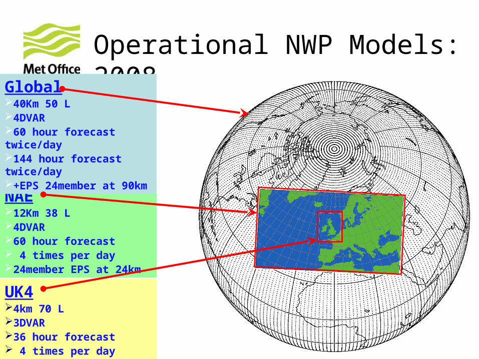
NAE12Km 38 L4DVAR60 hour forecast 4 times per day24member EPS at 24km
UK44km 70 L3DVAR36 hour forecast 4 times per day
Operational NWP Models: 2008Global
40Km 50 L4DVAR60 hour forecast twice/day144 hour forecast twice/day+EPS 24member at 90km
© Crown copyright Met Office
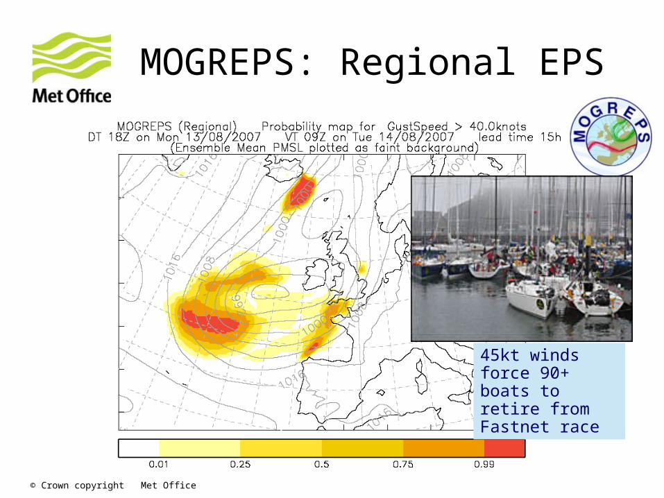
MOGREPS: Regional EPS
45kt winds force 90+ boats to retire from Fastnet race
© Crown copyright Met Office
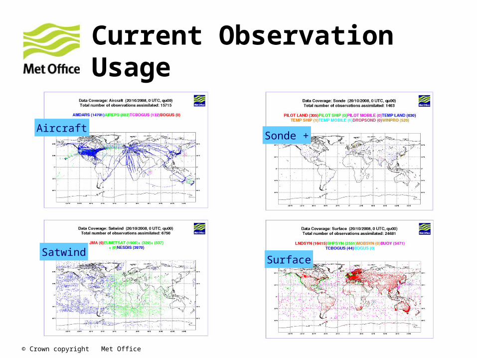
Current Observation Usage
AircraftSonde +
SatwindSurface
© Crown copyright Met Office
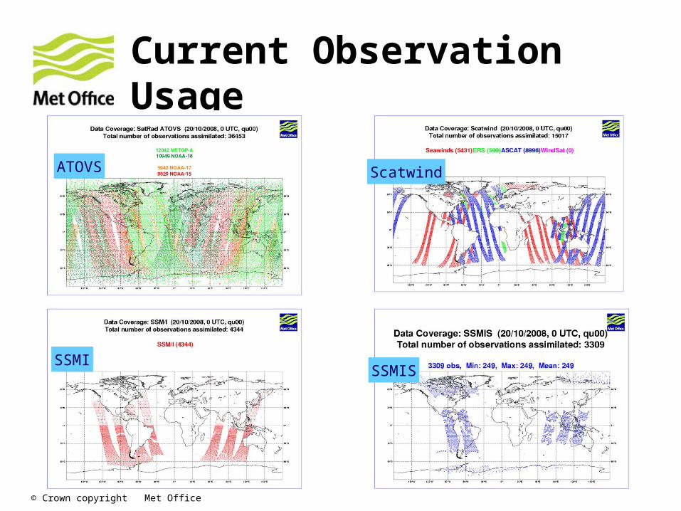
Current Observation Usage
ATOVS Scatwind
SSMISSMIS

© Crown copyright Met Office
Current Observation Usage
Ground GPSGPS RO
IASIAIRS
© Crown copyright Met Office
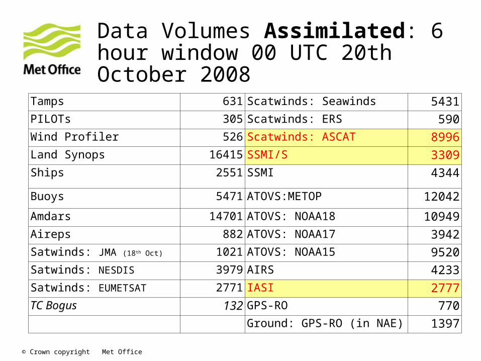
Data Volumes Assimilated: 6 hour window 00 UTC 20th October 2008
Tamps 631 Scatwinds: Seawinds 5431PILOTs 305 Scatwinds: ERS 590Wind Profiler 526 Scatwinds: ASCAT 8996Land Synops 16415 SSMI/S 3309Ships 2551 SSMI 4344
Buoys 5471 ATOVS:METOP 12042
Amdars 14701 ATOVS: NOAA18 10949Aireps 882 ATOVS: NOAA17 3942Satwinds: JMA (18th Oct) 1021 ATOVS: NOAA15 9520Satwinds: NESDIS 3979 AIRS 4233Satwinds: EUMETSAT 2771 IASI 2777TC Bogus 132 GPS-RO 770
Ground: GPS-RO (in NAE) 1397
© Crown copyright Met Office
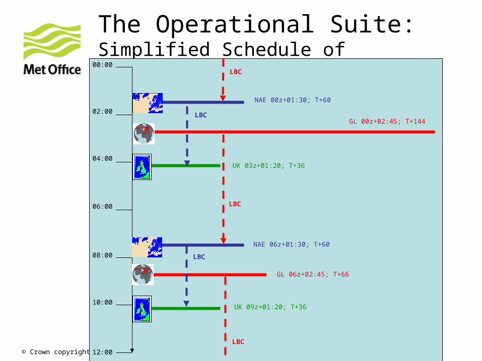
The Operational Suite: Simplified Schedule of Atmosphere Models. Excluding Update Cycles
00:00
02:00
04:00
06:00
08:00
10:00
12:00
NAE 00z+01:30; T+60
NAE 06z+01:30; T+60
GL 00z+02:45; T+144
GL 06z+02:45; T+66
UK 03z+01:20; T+36
UK 09z+01:20; T+36
LBC
LBC
LBC
LBC
LBC
© Crown copyright Met Office
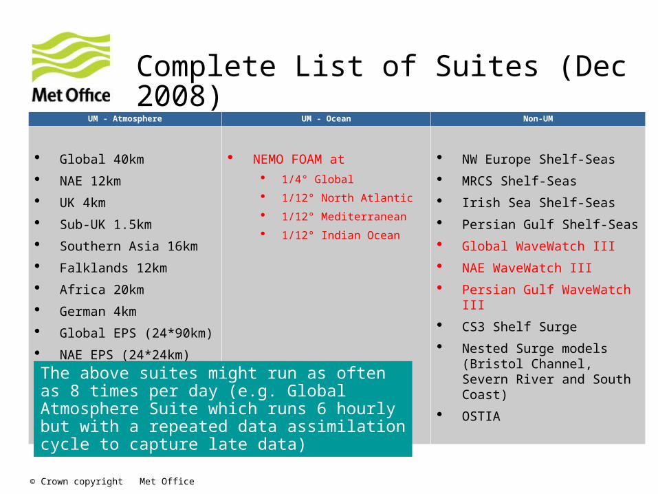
Complete List of Suites (Dec 2008)
UM - Atmosphere UM - Ocean Non-UM
Global 40km
NAE 12km
UK 4km
Sub-UK 1.5km
Southern Asia 16km
Falklands 12km
Africa 20km
German 4km
Global EPS (24*90km)
NAE EPS (24*24km)
NEMO FOAM at 1/4° Global
1/12° North Atlantic
1/12° Mediterranean
1/12° Indian Ocean
NW Europe Shelf-Seas
MRCS Shelf-Seas
Irish Sea Shelf-Seas
Persian Gulf Shelf-Seas
Global WaveWatch III
NAE WaveWatch III
Persian Gulf WaveWatch III
CS3 Shelf Surge
Nested Surge models (Bristol Channel, Severn River and South Coast)
OSTIAThe above suites might run as often as 8 times per day (e.g. Global Atmosphere Suite which runs 6 hourly but with a repeated data assimilation cycle to capture late data)
© Crown copyright Met Office
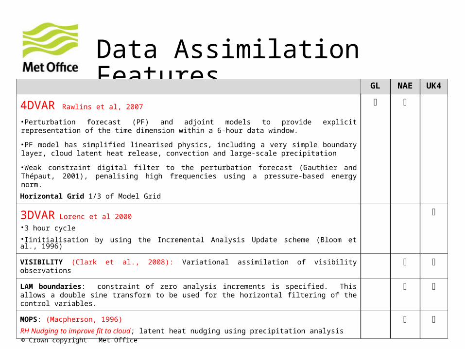
Data Assimilation Features GL NAE UK4
4DVAR Rawlins et al, 2007
•Perturbation forecast (PF) and adjoint models to provide explicit representation of the time dimension within a 6-hour data window.
•PF model has simplified linearised physics, including a very simple boundary layer, cloud latent heat release, convection and large-scale precipitation
•Weak constraint digital filter to the perturbation forecast (Gauthier and Thépaut, 2001), penalising high frequencies using a pressure-based energy norm.
Horizontal Grid 1/3 of Model Grid
3DVAR Lorenc et al 2000
•3 hour cycle
•Iinitialisation by using the Incremental Analysis Update scheme (Bloom et al., 1996)
VISIBILITY (Clark et al., 2008): Variational assimilation of visibility observations
LAM boundaries: constraint of zero analysis increments is specified. This allows a double sine transform to be used for the horizontal filtering of the control variables.
MOPS: (Macpherson, 1996)
RH Nudging to improve fit to cloud; latent heat nudging using precipitation analysis
© Crown copyright Met Office
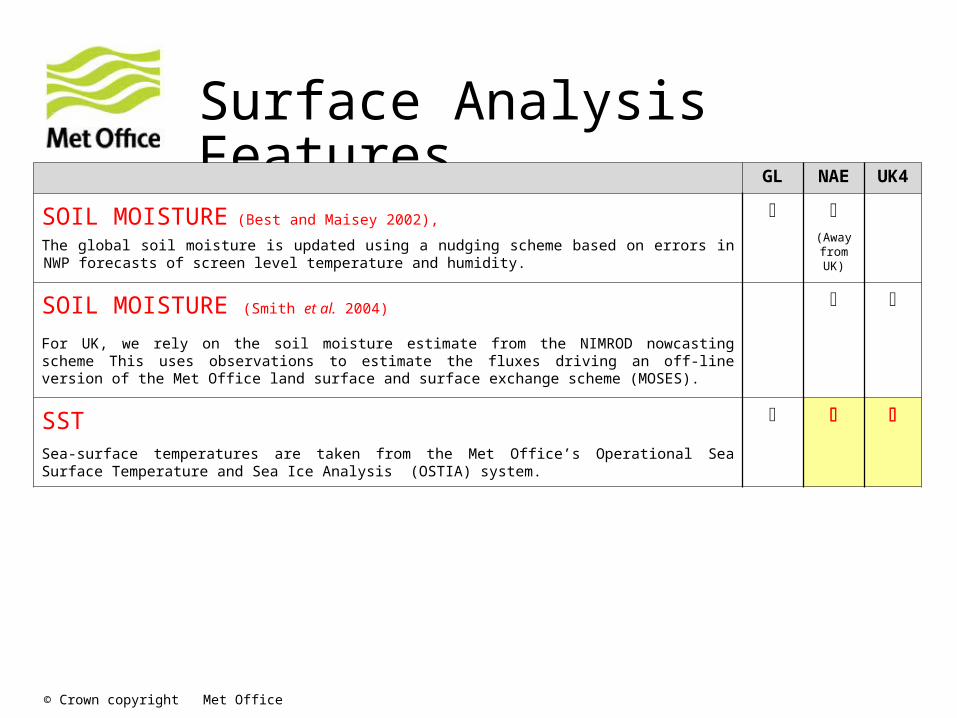
Surface Analysis FeaturesGL NAE UK4
SOIL MOISTURE (Best and Maisey 2002),
The global soil moisture is updated using a nudging scheme based on errors in NWP forecasts of screen level temperature and humidity.
(Away
from UK)
SOIL MOISTURE (Smith et al. 2004)
For UK, we rely on the soil moisture estimate from the NIMROD nowcasting scheme This uses observations to estimate the fluxes driving an off-line version of the Met Office land surface and surface exchange scheme (MOSES).
SSTSea-surface temperatures are taken from the Met Office’s Operational Sea Surface Temperature and Sea Ice Analysis (OSTIA) system.
© Crown copyright Met Office
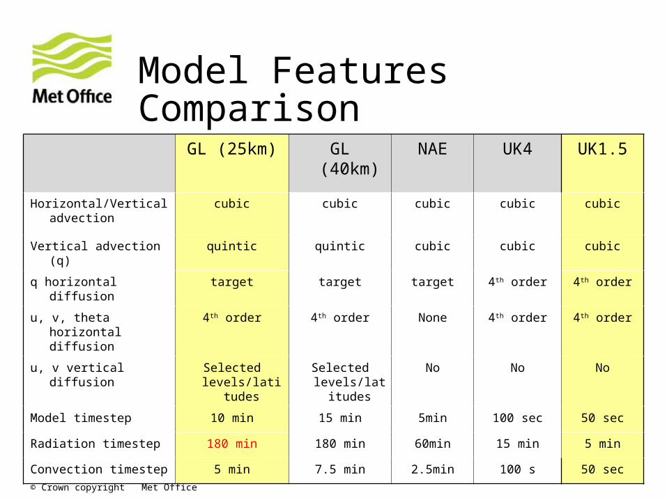
Model Features Comparison
GL (25km) GL (40km) NAE UK4 UK1.5
Horizontal/Vertical advection
cubic cubic cubic cubic cubic
Vertical advection (q) quintic quintic cubic cubic cubic
q horizontal diffusion target target target 4th order 4th order
u, v, theta horizontal diffusion
4th order 4th order None 4th order 4th order
u, v vertical diffusion Selected levels/latitude
s
Selected levels/latitu
des
No No No
Model timestep 10 min 15 min 5min 100 sec 50 sec
Radiation timestep 180 min 180 min 60min 15 min 5 min
Convection timestep 5 min 7.5 min 2.5min 100 s 50 sec
© Crown copyright Met Office
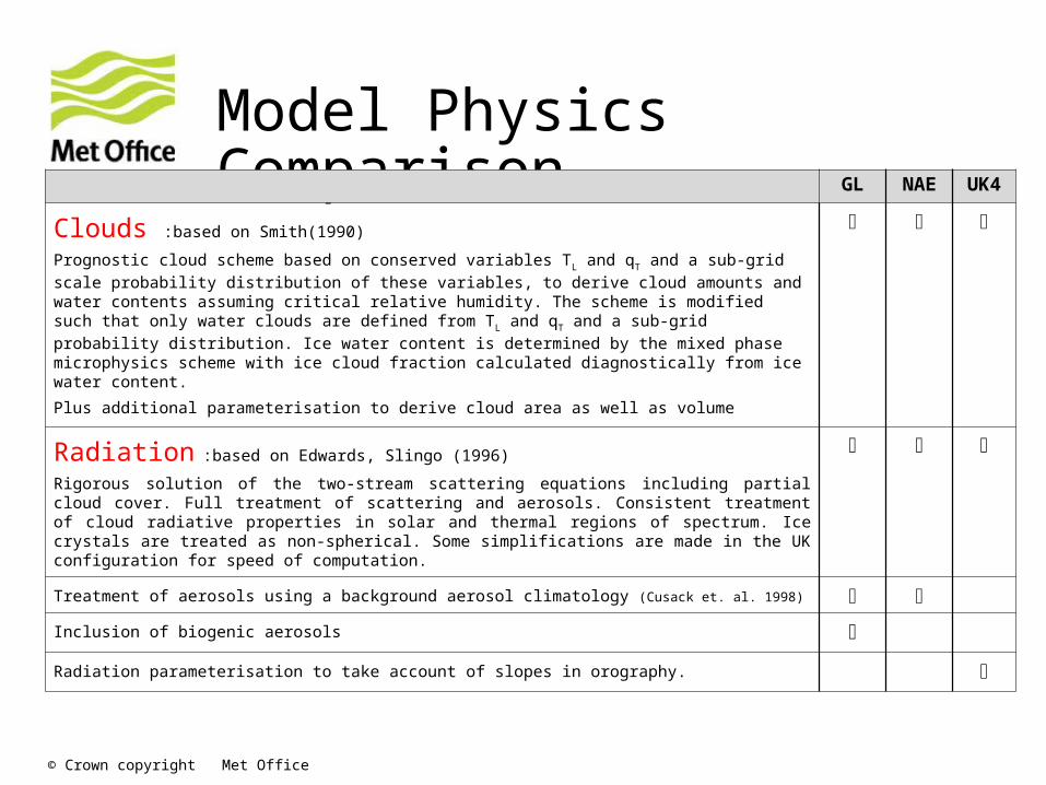
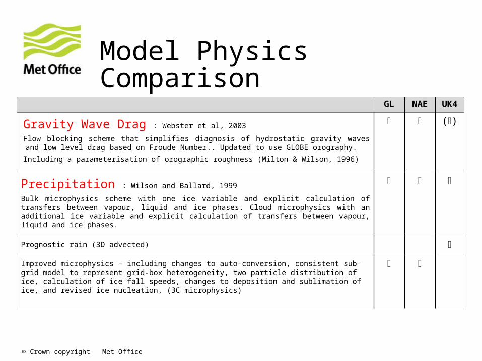
Model Physics Comparison GL NAE UK4
Clouds :based on Smith(1990)
Prognostic cloud scheme based on conserved variables TL and qT and a sub-grid scale probability distribution of these variables, to derive cloud amounts and water contents assuming critical relative humidity. The scheme is modified such that only water clouds are defined from TL and qT and a sub-grid probability distribution. Ice water content is determined by the mixed phase microphysics scheme with ice cloud fraction calculated diagnostically from ice water content.
Plus additional parameterisation to derive cloud area as well as volume
Radiation :based on Edwards, Slingo (1996)
Rigorous solution of the two-stream scattering equations including partial cloud cover. Full treatment of scattering and aerosols. Consistent treatment of cloud radiative properties in solar and thermal regions of spectrum. Ice crystals are treated as non-spherical. Some simplifications are made in the UK configuration for speed of computation.
Treatment of aerosols using a background aerosol climatology (Cusack et. al. 1998)
Inclusion of biogenic aerosols
Radiation parameterisation to take account of slopes in orography.
© Crown copyright Met Office
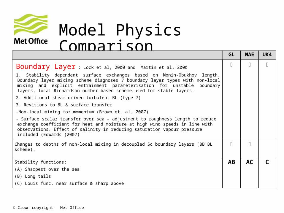
Model Physics Comparison
GL NAE UK4
Boundary Layer : Lock et al, 2000 and Martin et al, 2000
1. Stability dependent surface exchanges based on Monin-Obukhov length. Boundary layer mixing scheme diagnoses 7 boundary layer types with non-local mixing and explicit entrainment parameterisation for unstable boundary layers, local Richardson number-based scheme used for stable layers.
2. Additional shear driven turbulent BL (type 7)
3. Revisions to BL & surface transfer
-Non-local mixing for momentum (Brown et. al. 2007)
- Surface scalar transfer over sea – adjustment to roughness length to reduce exchange coefficient for heat and moisture at high wind speeds in line with observations. Effect of salinity in reducing saturation vapour pressure included (Edwards (2007)
Changes to depths of non-local mixing in decoupled Sc boundary layers (8B BL scheme).
Stability functions:
(A) Sharpest over the sea
(B) Long tails
(C) Louis func. near surface & sharp above
AB AC C
© Crown copyright Met Office
Model Physics Comparison
GL NAE UK4
Gravity Wave Drag : Webster et al, 2003
Flow blocking scheme that simplifies diagnosis of hydrostatic gravity waves and low level drag based on Froude Number.. Updated to use GLOBE orography.
Including a parameterisation of orographic roughness (Milton & Wilson, 1996)
()
Precipitation : Wilson and Ballard, 1999
Bulk microphysics scheme with one ice variable and explicit calculation of transfers between vapour, liquid and ice phases. Cloud microphysics with an additional ice variable and explicit calculation of transfers between vapour, liquid and ice phases.
Prognostic rain (3D advected)
Improved microphysics – including changes to auto-conversion, consistent sub-grid model to represent grid-box heterogeneity, two particle distribution of ice, calculation of ice fall speeds, changes to deposition and sublimation of ice, and revised ice nucleation, (3C microphysics)
© Crown copyright Met Office
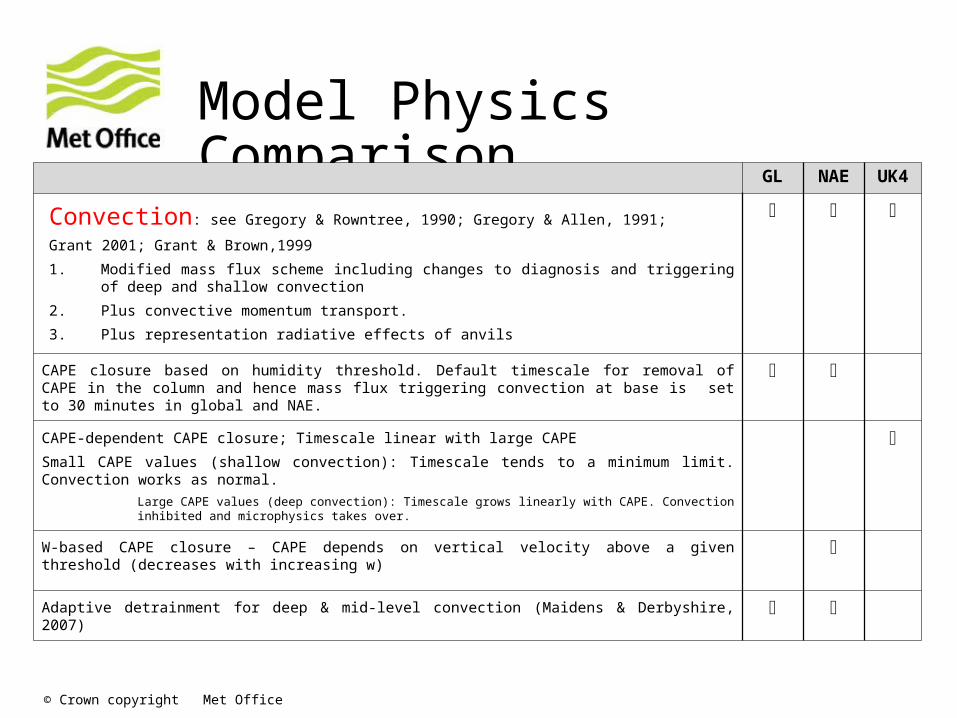
Model Physics Comparison GL NAE UK4
Convection: see Gregory & Rowntree, 1990; Gregory & Allen, 1991;
Grant 2001; Grant & Brown,1999
1. Modified mass flux scheme including changes to diagnosis and triggering of deep and shallow convection
2. Plus convective momentum transport.
3. Plus representation radiative effects of anvils
CAPE closure based on humidity threshold. Default timescale for removal of CAPE in the column and hence mass flux triggering convection at base is set to 30 minutes in global and NAE.
CAPE-dependent CAPE closure; Timescale linear with large CAPE
Small CAPE values (shallow convection): Timescale tends to a minimum limit. Convection works as normal.
Large CAPE values (deep convection): Timescale grows linearly with CAPE. Convection inhibited and microphysics takes over.
W-based CAPE closure – CAPE depends on vertical velocity above a given threshold (decreases with increasing w)
Adaptive detrainment for deep & mid-level convection (Maidens & Derbyshire, 2007)
© Crown copyright Met Office
Model Physics Comparison GL NAE UK4
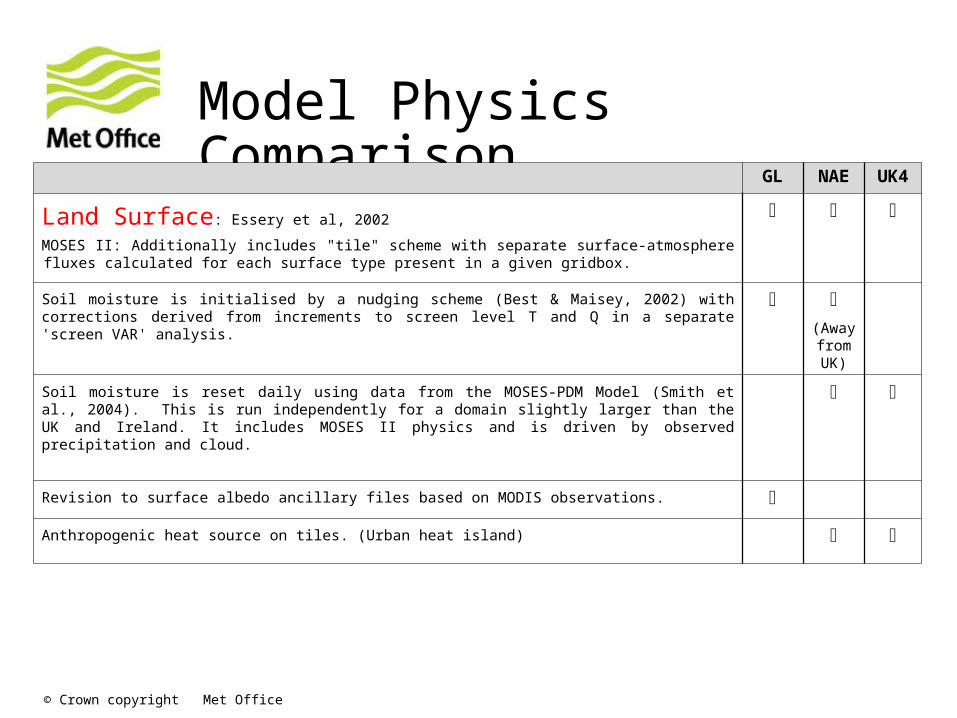
Land Surface: Essery et al, 2002
MOSES II: Additionally includes "tile" scheme with separate surface-atmosphere fluxes calculated for each surface type present in a given gridbox.
Soil moisture is initialised by a nudging scheme (Best & Maisey, 2002) with corrections derived from increments to screen level T and Q in a separate 'screen VAR' analysis.
(Away from UK)
Soil moisture is reset daily using data from the MOSES-PDM Model (Smith et al., 2004). This is run independently for a domain slightly larger than the UK and Ireland. It includes MOSES II physics and is driven by observed precipitation and cloud.
Revision to surface albedo ancillary files based on MODIS observations.
Anthropogenic heat source on tiles. (Urban heat island)
© Crown copyright Met Office
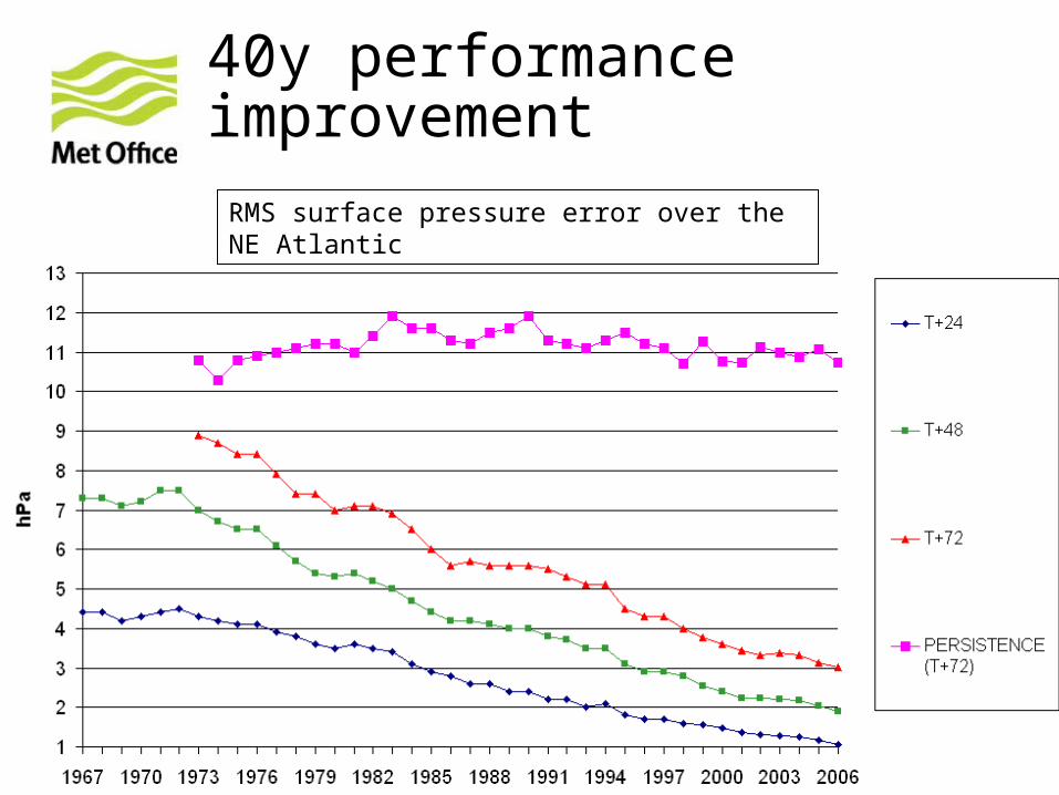
40y performance improvement
RMS surface pressure error over the NE Atlantic
© Crown copyright Met Office
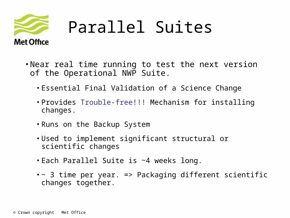
Parallel Suites
•Near real time running to test the next version of the Operational NWP Suite.
•Essential Final Validation of a Science Change
•Provides Trouble-free!!! Mechanism for installing changes.
•Runs on the Backup System
•Used to implement significant structural or scientific changes
•Each Parallel Suite is ~4 weeks long.
•~ 3 time per year. => Packaging different scientific changes together.
© Crown copyright Met Office
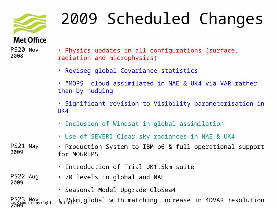
2009 Scheduled Changes
PS20 Nov 2008
• Physics updates in all configurations (surface, radiation and microphysics)
• Revised global Covariance statistics
• “MOPS” cloud assimilated in NAE & UK4 via VAR rather than by nudging
• Significant revision to Visibility parameterisation in UK4
• Inclusion of Windsat in global assimilation
• Use of SEVERI Clear sky radiances in NAE & UK4
PS21 May 2009
• Production System to IBM p6 & full operational support for MOGREPS
• Introduction of Trial UK1.5km suite
PS22 Aug 2009
• 70 levels in global and NAE
• Seasonal Model Upgrade GloSea4
PS23 Nov 2009
• 25km global with matching increase in 4DVAR resolution
• 60km global EPS and 16km regional EPS
© Crown copyright Met Office
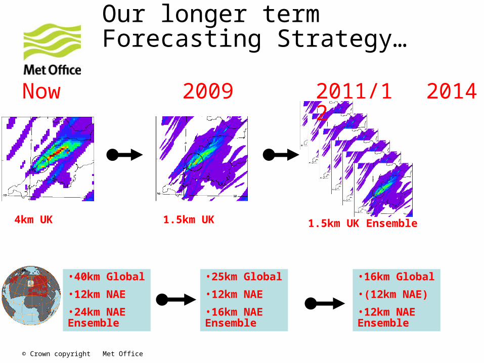
Our longer term Forecasting Strategy…
1km
2009 2011/12 2014
1.5km UK 1.5km UK Ensemble
•25km Global
•12km NAE
•16km NAE Ensemble
•16km Global
•(12km NAE)
•12km NAE Ensemble
Now
•40km Global
•12km NAE
•24km NAE Ensemble
4km UK
© Crown copyright Met Office
Climate models, coupling & seamless prediction
© Crown copyright Met Office
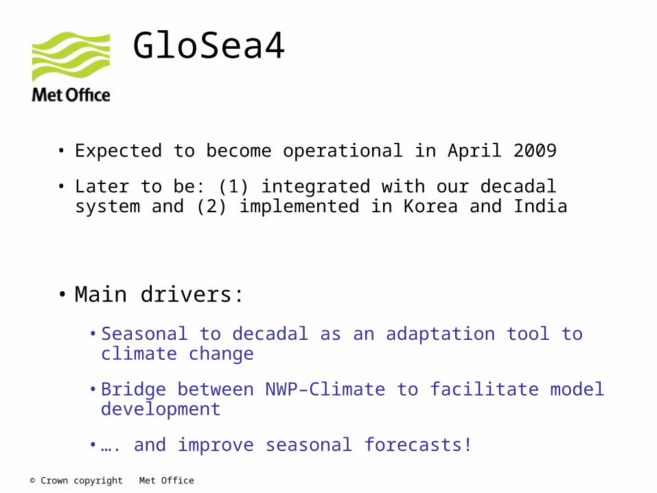
GloSea4
• Expected to become operational in April 2009
• Later to be: (1) integrated with our decadal system and (2) implemented in Korea and India
• Main drivers:
•Seasonal to decadal as an adaptation tool to climate change
•Bridge between NWP–Climate to facilitate model development
•…. and improve seasonal forecasts!

© Crown copyright Met Office
Monday
ADA(NWP) + ODA
Weekly ICs
N forecasts (6-month)
Archiving/post-processing
GloSea4 prototype:System design/infrastructure
Tue - Sun
ADA(NWP) + ODA
N forecasts (6-month)
Archiving/post-processingFC
ST
Every week
• Pull together last 4-weeks fcsts/hcst
• Post-processing
• Products / web displayEvery day
‘Weekly’ ICs
N forecasts (6-month): Y-years, M-members
Archiving/post-processingHC
ST
Off line
• Continuous ODA (e.g. 1989 – 1998)
• ‘Weekly’ Atmos + land.surf. Reanalysis data
© Crown copyright Met Office
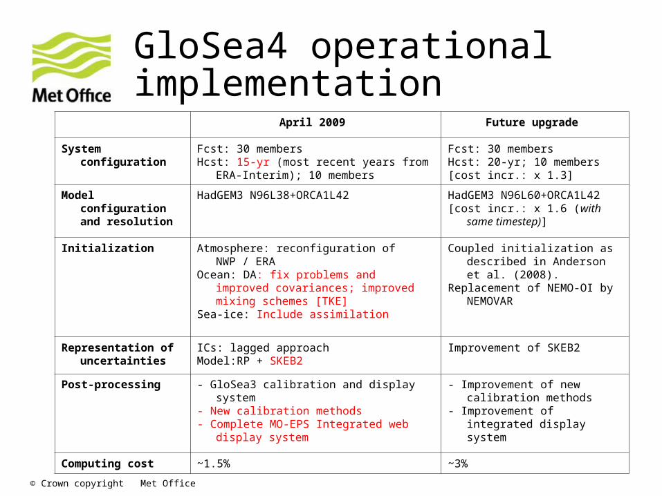
GloSea4 operational implementation
April 2009 Future upgrade
System configuration
Fcst: 30 membersHcst: 15-yr (most recent years from ERA-
Interim); 10 members
Fcst: 30 membersHcst: 20-yr; 10 members [cost incr.: x 1.3]
Model configuration and resolution
HadGEM3 N96L38+ORCA1L42 HadGEM3 N96L60+ORCA1L42 [cost incr.: x 1.6 (with same
timestep)]
Initialization Atmosphere: reconfiguration of NWP / ERAOcean: DA: fix problems and improved
covariances; improved mixing schemes [TKE]
Sea-ice: Include assimilation
Coupled initialization as described in Anderson et al. (2008).
Replacement of NEMO-OI by NEMOVAR
Representation of uncertainties
ICs: lagged approachModel:RP + SKEB2
Improvement of SKEB2
Post-processing - GloSea3 calibration and display system- New calibration methods- Complete MO-EPS Integrated web display
system
- Improvement of new calibration methods
- Improvement of integrated display system
Computing cost ~1.5% ~3%

© Crown copyright Met Office
HadGEM family• HadGEM1
•IPCC AR4 (CMIP3)
• HadGEM2-AO
•ENSEMBLES
•Physical model for HadGEM2-ES
• HadGEM2-ES
•IPCC AR5
• HadGEM3-AO
•Under development
•Uses NEMO and CICE models
•Basis for GloSea4
© Crown copyright Met Office
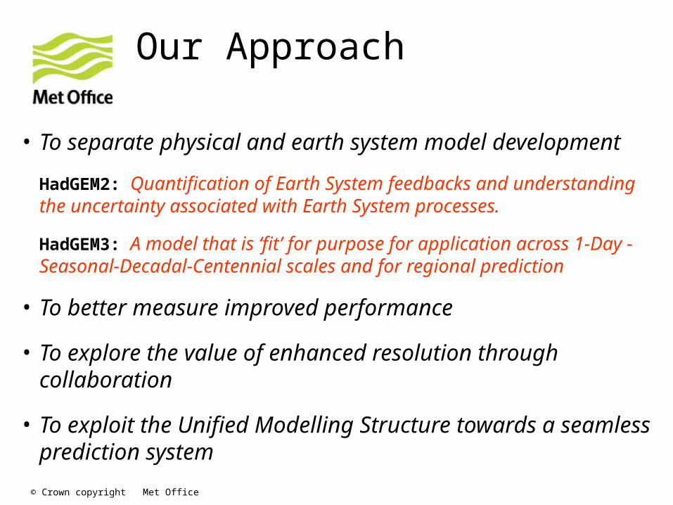
Our Approach
• To separate physical and earth system model development
HadGEM2: Quantification of Earth System feedbacks and understanding the uncertainty associated with Earth System processes.
HadGEM3: A model that is ‘fit’ for purpose for application across 1-Day -Seasonal-Decadal-Centennial scales and for regional prediction
• To better measure improved performance
• To explore the value of enhanced resolution through collaboration
• To exploit the Unified Modelling Structure towards a seamless prediction system
© Crown copyright Met Office
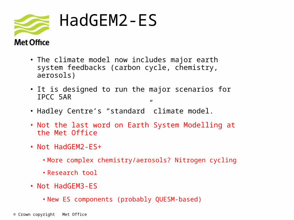
HadGEM2-ES
• The climate model now includes major earth system feedbacks (carbon cycle, chemistry, aerosols)
• It is designed to run the major scenarios for IPCC 5AR
• Hadley Centre’s “standard” climate model.
• Not the last word on Earth System Modelling at the Met Office
• Not HadGEM2-ES+
• More complex chemistry/aerosols? Nitrogen cycling
• Research tool
• Not HadGEM3-ES
• New ES components (probably QUESM-based)
© Crown copyright Met Office
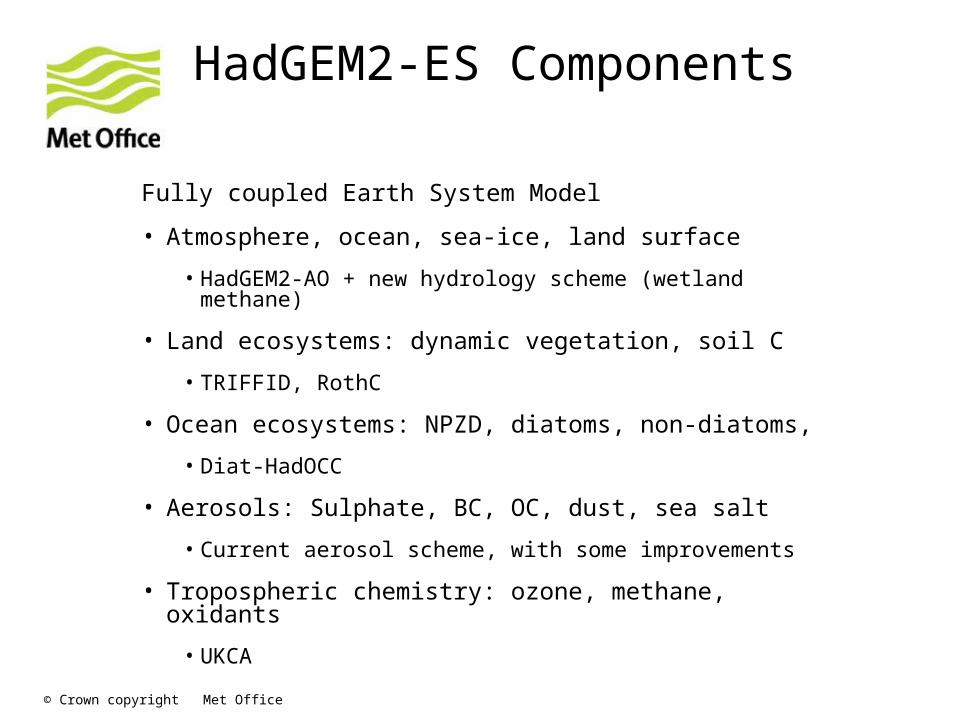
HadGEM2-ES Components
Fully coupled Earth System Model
• Atmosphere, ocean, sea-ice, land surface
• HadGEM2-AO + new hydrology scheme (wetland methane)
• Land ecosystems: dynamic vegetation, soil C
• TRIFFID, RothC
• Ocean ecosystems: NPZD, diatoms, non-diatoms,
• Diat-HadOCC
• Aerosols: Sulphate, BC, OC, dust, sea salt
• Current aerosol scheme, with some improvements
• Tropospheric chemistry: ozone, methane, oxidants
• UKCA
© Crown copyright Met Office
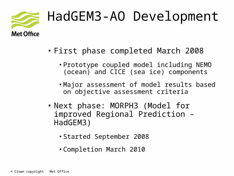
HadGEM3-AO Development
• First phase completed March 2008
•Prototype coupled model including NEMO (ocean) and CICE (sea ice) components
•Major assessment of model results based on objective assessment criteria
• Next phase: MORPH3 (Model for improved Regional Prediction – HadGEM3)
•Started September 2008
•Completion March 2010
© Crown copyright Met Office
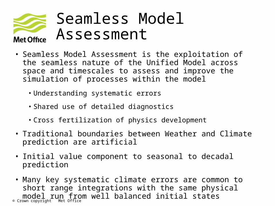
Seamless Model Assessment
• Seamless Model Assessment is the exploitation of the seamless nature of the Unified Model across space and timescales to assess and improve the simulation of processes within the model
• Understanding systematic errors
• Shared use of detailed diagnostics
• Cross fertilization of physics development
• Traditional boundaries between Weather and Climate prediction are artificial
• Initial value component to seasonal to decadal prediction
• Many key systematic climate errors are common to short range integrations with the same physical model run from well balanced initial states

© Crown copyright Met Office
Met Office physical models 2009
Regional NWPNAE
(2 days)
Global NWP
(6 days)
THORPEX(15 days)
Seasonal
(GloSea4)
Decadal(DePreSy
s)
Centennial
Regional Climate
Horizontal Resolution
12km 25km – N512 60km – N216 135km – N96
250km – N48
135km – N96
25km
Vertical Resolution
70 L 70 L 70 L 38L 19L 38L 38L
Atmos Physics
HadGAM2 + upgrades
HadGAM2 + upgrades
HadGAM2 + upgrades
HadGAM2 + upgrades
HadAM3 HadGAM2 HadCM3
Atmos. data assimilation
4D-Var (3h cycle) MOPSLH nudging
4D-Var Reconfigured Global Analysis
Reconfigure ERA-40
Relaxation to ERA-40
N/A N/A
Soil moisture initialisation
Reconfigured daily from Global soil moisture
Soil nudging Global “nudged” analy.
UM analysis.
N/A N/A N/A
Ocean Persisted SST Persisted SST Persisted SST anomalies.
NEMO (1.25°, 1/3 ° tropics)
HadCM3 (1.25°)
HadGOM1 + upgrades (1°, 1/3° tropics)
Driven by HadCM3
SSTs
Ocean data Assimilation
N/A N/A N/A FOAM – Met Office global Ocean data assimilation
4D, multi-variate OI of salinity, sub surf.T ,SST’s.
N/A N/A
Ensembles
MOGREPS 24 member ETKF 16km/70L
MOGREPS 24 member ETKF (Bowler(06)) N216/70L
24 member ensemble from MOGREPS perturbations
40 member 16 member (initialised on different days & seasons).
HadCM3 QUMP PPE ensemble
© Crown copyright Met Office
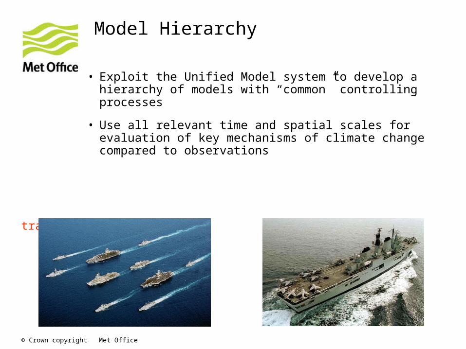
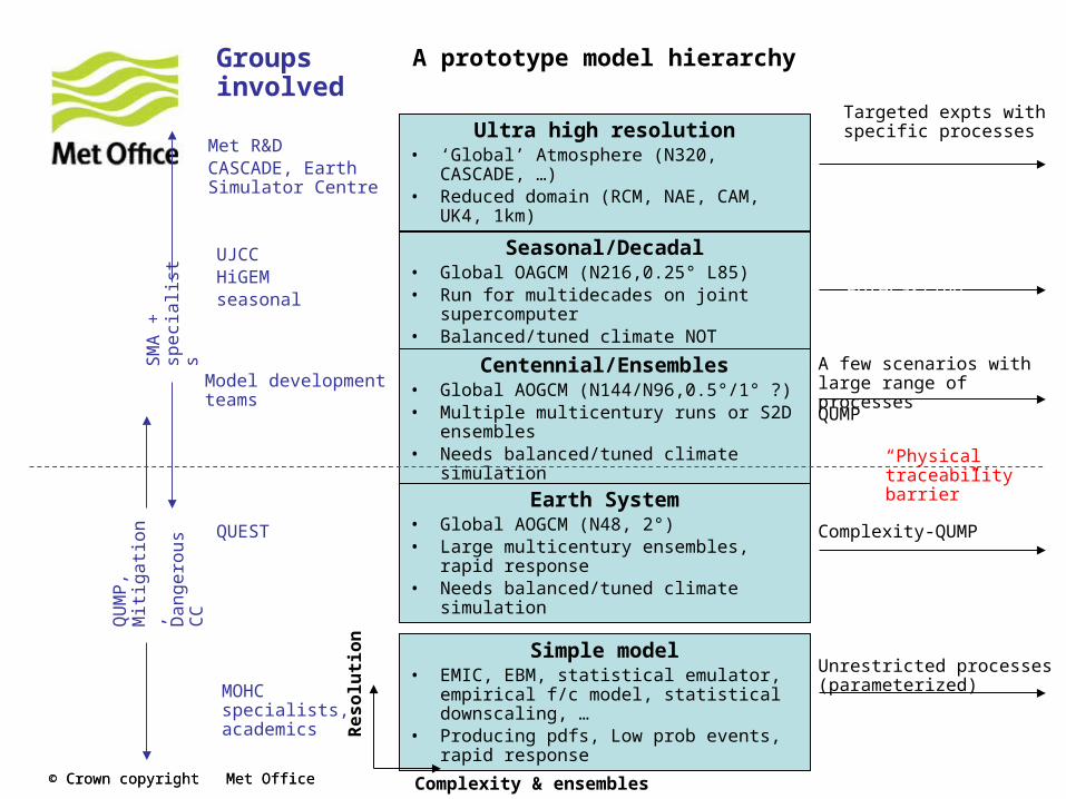
Model Hierarchy
• Exploit the Unified Model system to develop a hierarchy of models with “common” controlling processes
• Use all relevant time and spatial scales for evaluation of key mechanisms of climate change compared to observations
Instead of a flagship model, we need a reference model. For particular purposes, we need lower/higher resolution or more/less complexity.
This is not a new idea. The challenge in implementing it is traceability.
© Crown copyright Met Office© Crown copyright Met Office
A prototype model hierarchy
Ultra high resolution• ‘Global’ Atmosphere (N320, CASCADE, …)• Reduced domain (RCM, NAE, CAM, UK4,
1km)
Seasonal/Decadal• Global OAGCM (N216,0.25° L85)• Run for multidecades on joint supercomputer• Balanced/tuned climate NOT required
Centennial/Ensembles• Global AOGCM (N144/N96,0.5°/1° ?)• Multiple multicentury runs or S2D ensembles• Needs balanced/tuned climate simulation
Earth System• Global AOGCM (N48, 2°)• Large multicentury ensembles, rapid
response• Needs balanced/tuned climate simulation
Simple model• EMIC, EBM, statistical emulator, empirical f/c
model, statistical downscaling, …• Producing pdfs, Low prob events, rapid
response
Targeted expts with specific processes
A few scenarios with large range of processes
QUMP
Complexity-QUMP
Unrestricted processes (parameterized)
Complexity & ensembles
Re
so
luti
on
Met R&DCASCADE, Earth Simulator Centre
UJCCHiGEMseasonal
Model development teams
QUEST
QU
MP
, M
itig
atio
n,
Da
ng
ero
us
CC
SM
A +
sp
eci
alis
ts
Groups involved
“Physical traceability barrier”
MOHC specialists, academics
Operational Seasonal and Decadal Forecasting

© Crown copyright Met Office
UM licensing and collaboration
© Crown copyright Met Office
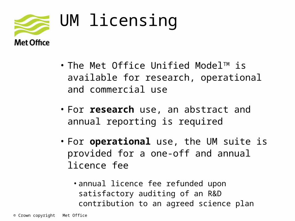
UM licensing
• The Met Office Unified ModelTM is available for research, operational and commercial use
• For research use, an abstract and annual reporting is required
• For operational use, the UM suite is provided for a one-off and annual licence fee
•annual licence fee refunded upon satisfactory auditing of an R&D contribution to an agreed science plan

© Crown copyright Met Office
Intellectual Property Rights
• UM IPR remains with the Met Office
• Licensees must acknowledge the Met Office using “Met Office Unified ModelTM ” in publications etc.
• Background IP remains with the Met Office and foreground IP shall be assigned back to the Met Office
© Crown copyright Met Office
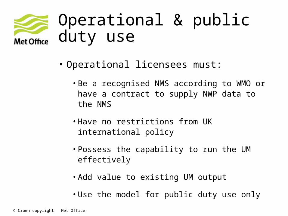
Operational & public duty use
• Operational licensees must:
•Be a recognised NMS according to WMO or have a contract to supply NWP data to the NMS
•Have no restrictions from UK international policy
•Possess the capability to run the UM effectively
•Add value to existing UM output
•Use the model for public duty use only
© Crown copyright Met Office
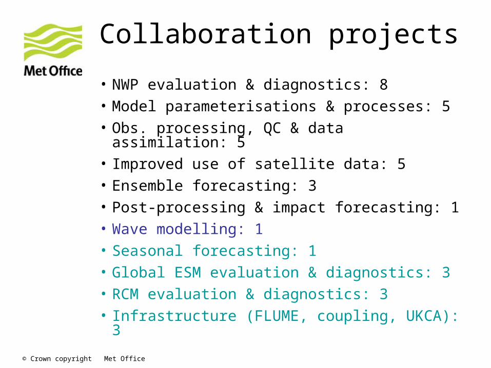
Collaboration projects
• NWP evaluation & diagnostics: 8• Model parameterisations & processes: 5• Obs. processing, QC & data assimilation:
5• Improved use of satellite data: 5• Ensemble forecasting: 3• Post-processing & impact forecasting: 1• Wave modelling: 1• Seasonal forecasting: 1• Global ESM evaluation & diagnostics: 3• RCM evaluation & diagnostics: 3• Infrastructure (FLUME, coupling, UKCA): 3

© Crown copyright Met Office
The ACCESS modelling system

© Crown copyright Met Office
OASIS
UM
CICECSIRO OC
UKCACABLE
AusCOM (MOM4)
LPJ
VAR
OPS
BODAS
OBS
Assimilation (?)
NWP
ACCESS modules
© Crown copyright Met Office
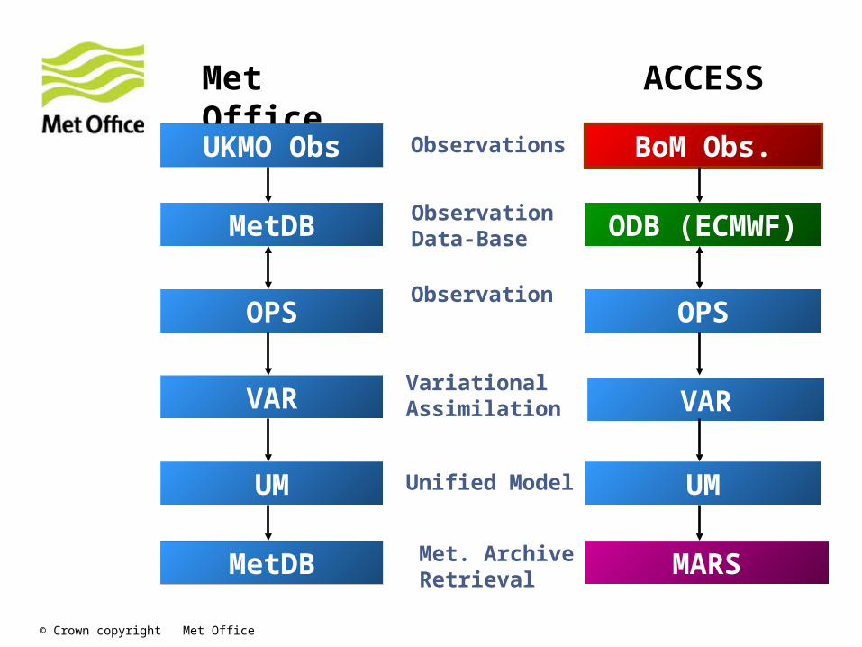
MetDB
OPS
VAR
UM
BoM Obs.
ODB (ECMWF)
OPS
VAR
UM
MARS
Met Office ACCESS
MetDB
UKMO Obs Observations
ObservationData-Base
Met. Archive Retrieval
Unified Model
VariationalAssimilation
Observation
© Crown copyright Met Office
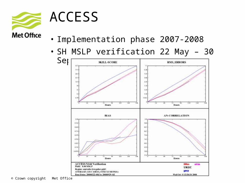
ACCESS
• Implementation phase 2007-2008
• SH MSLP verification 22 May – 30 Sep 2008:
© Crown copyright Met Office
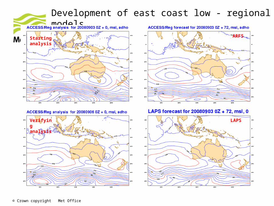
Development of east coast low - regional models
Starting analysis
Verifying analysis
ARFS
LAPS
© Crown copyright Met Office
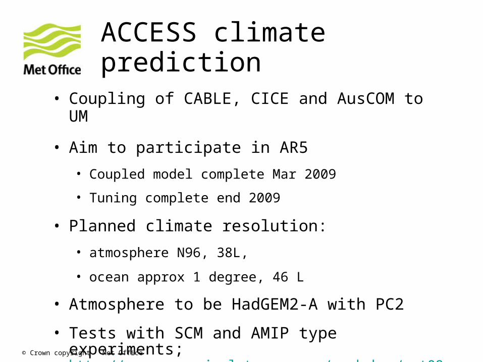
ACCESS climate prediction
• Coupling of CABLE, CICE and AusCOM to UM
• Aim to participate in AR5
• Coupled model complete Mar 2009
• Tuning complete end 2009
• Planned climate resolution:
• atmosphere N96, 38L,
• ocean approx 1 degree, 46 L
• Atmosphere to be HadGEM2-A with PC2
• Tests with SCM and AMIP type experiments; http://www.accessimulator.org.au/workshop/oct08.html

© Crown copyright Met Office
Questions and answers
© Crown copyright Met Office
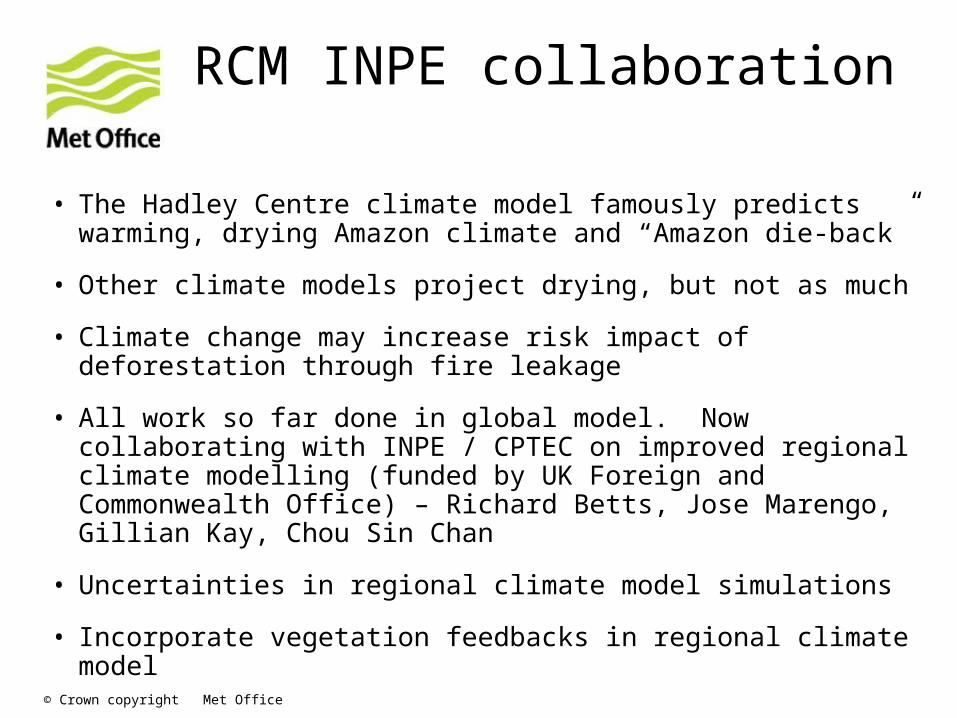
RCM INPE collaboration
• The Hadley Centre climate model famously predicts warming, drying Amazon climate and “Amazon die-back”
• Other climate models project drying, but not as much
• Climate change may increase risk impact of deforestation through fire leakage
• All work so far done in global model. Now collaborating with INPE / CPTEC on improved regional climate modelling (funded by UK Foreign and Commonwealth Office) – Richard Betts, Jose Marengo, Gillian Kay, Chou Sin Chan
• Uncertainties in regional climate model simulations
• Incorporate vegetation feedbacks in regional climate model

© Crown copyright Met Office
Impacts on ecosystems and role of climate feedbacks
Difference in forest area 2080-2000
Precipitation difference 2080 - 2000 (mm day-1)
Precipitation difference due to forest feedbacks (mm day-1)

© Crown copyright Met Office
Uncertainties in climate projections: changes in S American precipitation in Hadley Centre ensemble
© Crown copyright Met Office
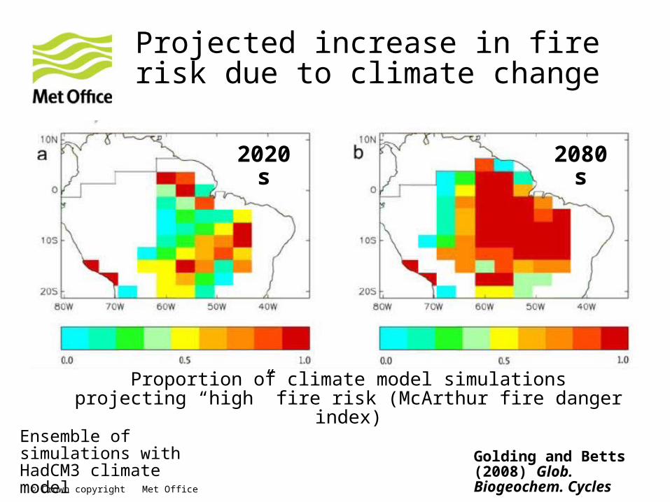
Projected increase in fire risk due to climate change
2020s 2080s
Proportion of climate model simulations projecting “high” fire risk (McArthur fire danger index)
Ensemble of simulations with HadCM3 climate model
Golding and Betts (2008) Glob. Biogeochem. Cycles
© Crown copyright Met Office
Satellite collaborations Met Office - CPTEC
• Atmospheric motion information from geostationary imagers e.g. SEVIRI
• Renato Galante planned visits to Met Office March 2009 and November 2009. The focus is on tropical convection.
• GPSRO
• Luiz Sapucci visit to Met Office April-May 2009
• Tropical humidity, land surface temperature
• Stephen English is planning to visit CPTEC March-April 2009 to compare humidity analyses, especially in the tropics, to initiate collaboration in assimilation of moisture observations in the tropics.
• Also a comparison of land surface temperature and methods for assimilating ATOVS is planned.
© Crown copyright Met Office
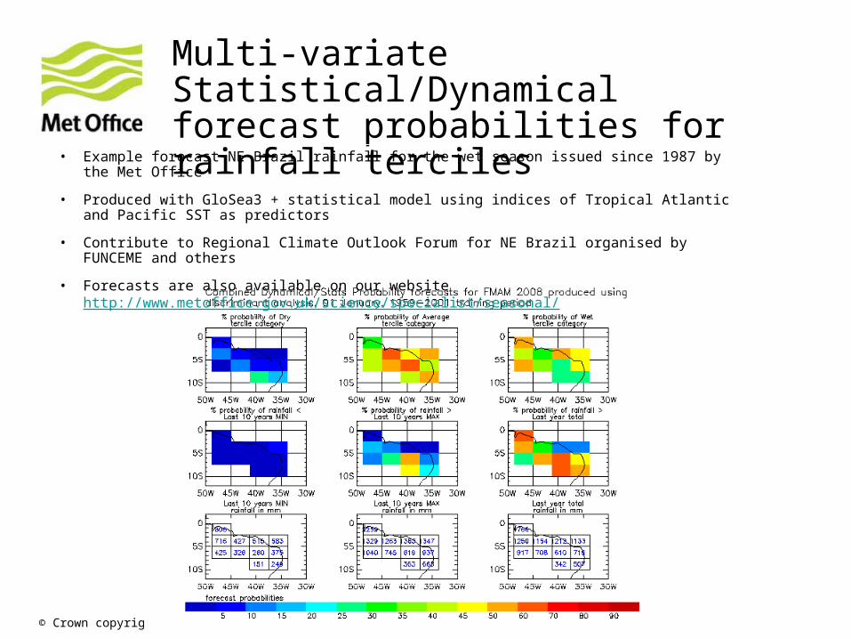
Multi-variate Statistical/Dynamical forecast probabilities for rainfall terciles
• Example forecast NE Brazil rainfall for the wet season issued since 1987 by the Met Office
• Produced with GloSea3 + statistical model using indices of Tropical Atlantic and Pacific SST as predictors
• Contribute to Regional Climate Outlook Forum for NE Brazil organised by FUNCEME and others
• Forecasts are also available on our websitehttp://www.metoffice.gov.uk/science/specialist/seasonal/