Illinois State Geological Survey Guidebook Series 9 PLEISTOCENE || STRATIGRAPHY OF EAST- CENTRAL ILLINOIS Midwest Friends of the Pleistocene 21 st Annual Field Conference May 12-14, 1972 Leaders: W. Hilton Johnson Leon R. Follmer David L. Gross Alon M. Jacobs Sponsored by ILLINOIS STATE GEOLOGICAL SURVEY in cooperation with DEPARTMENT OF GEOLOGY University of Illinois
Transcript
Illinois State Geological Survey
Guidebook Series 9
PLEISTOCENE
|| STRATIGRAPHY OFEAST- CENTRAL ILLINOIS
Midwest Friends of the Pleistocene
21 st Annual Field ConferenceMay 12-14, 1972
Leaders:
W. Hilton Johnson
Leon R. Follmer
David L. Gross
Alon M. Jacobs
Sponsored by
ILLINOIS STATE GEOLOGICAL SURVEYin cooperation with DEPARTMENT OF GEOLOGYUniversity of Illinois
MGHANJl
PLEISTOCENE STRATIGRAPHY OF EAST- CENTRAL ILLINOIS
W. H. Johnson, Leon Follmer , D. L. Gross, and A. M. Jacobs
INTRODUCTION
This field conference is designed (l) to show representative sectionsof the Pleistocene stratigraphy in two areas of east-central Illinois , one in
the area of Woodfordian drift and the other in the area of Illinoian drift; (2)
to demonstrate the emphasis on lithology in developing the rock-stratigraphicframework in the two areas and in making correlations between them; (3) to dem-
onstrate the magnitude of glacial and fluvial erosion during the Quaternary andthe resulting complexities in the stratigraphic record; and (U) to introduceseveral problems that as yet have not been satisfactorily solved in these areas.
The problems include, first, the determination of the source of many of the tillsin this part of Illinois, in particular the relationship of the Decatur Sublobeof the Erie Lobe to the Peoria Sublobe of the Lake Michigan Lobe (Willman andFrye , 1970), and, second, the nature of the Altonian record, particularly theorigin of Altonian sediments in the area of Illinoian drift.
In the past 15 years Pleistocene studies in Illinois have concentratedon the physical characteristics of the deposits and their distribution in spacebecause this information is needed in applied geology. The result of this ap-proach has been the development of a sound rock-stratigraphic framework, whichin turn has significantly contributed to our understanding of the Pleistocenehistory in Illinois. Willman and Frye (1970) recently summarized this historyand the Pleistocene stratigraphy of Illinois , with emphasis on the stratigraphyof western and northern Illinois where their work was concentrated. This fieldconference provides an opportunity to summarize similar data for a portion ofeastern Illinois.
LOCATION
The field conference will concentrate on two relatively small areas,one in central Vermilion County in the area of Woodfordian drift, and the otherin southern Coles and Cumberland Counties encompassing an area of Woodfordian
- 1 -
^JO DAVIESS
ILLINOIS STATE GEOLOGICAL SURVEY %John C.Frye, Chief Urbano, Illinois 61801
V
GLACIAL MAP OF ILLINOIS
H.B. WILLMAN and JOHN C.FRYE <\
1970
Modified from maps by Leverett (1899), > \
Ekblaw (1959), Leighton and Brophy (1961), \"Willman et al.(l967), and others
EXPLANATION
HOLOCENE AND WISCONSINAN
Alluvium, sand dunes,and gravel terraces
WISCONSINAN
Lake deposits
WOODFORDIAN
Moraine
Front of morainic system
Groundmoraine
ALTONIAN
Till plain
ILLINOIAN
Moraine and ridged drift
Groundmoraine
KANSAN
Till plain
DRIFTLESS
^ Field trip areasFig. 1.
- 3 -
drift and an area of Illinoian drift just south of the Woodfordian limit (fig. l)
The Pleistocene stratigraphy of these two small areas is representative of the
regional stratigraphy of both the Woodfordian drift in the Decatur Sublobe and
the Illinoian and older drift in the eastern part of Illinois. Saturday will bespent in the northern area, Sunday in the southern area, and the conference willend near the town of Jewett, in Cumberland County, Sunday at 1 p.m.
Acknowledgment s
Much of our knowledge of the Pleistocene geology of east-central Illi-
nois has been derived from the studies George W. White, his students, and his
associates made of the strip-mine exposures in the Danville area.
Also important to this conference are the efforts of several membersof the Illinois State Geological Survey staff. Analyses of clay minerals weremade by H. D. Glass, the grain-size analyses by W. A. White and his assistants,radiocarbon dating by Dennis Coleman, studies of molluscan faunas by A. ByronLeonard, and chemical analyses by David B. Heck. John C. Frye and H. B. Willmancorroborated field relations and assisted in assigning rock- and soil-strati-graphic names.
REGIONAL STRATIGRAPHY
Introduction
The field conference will focus on Pleistocene studies made in thepast six years by P. B. DuMontelle , L. R. Follmer, J. P. Ford, H. D. Glass,D. L. Gross, A. M. Jacobs, W. H. Johnson, J. P. Kempton , J. A. Lineback, andS. R. Moran. Some of the studies have been published (Jacobs and Lineback,1969; Johnson et al. , 1971; Johnson, Gross, and Moran, in press; Johnson, 1971;and Kempton, DuMontelle, and Glass, in press) while other studies are continuingor nearing completion. The latter include work by Follmer on some of the pale-osols and loesses, a study of Coles County by Ford, one on Vermilion County byJohnson, work in the area of the Decatur 2° sheet by Lineback, and a regionalsynthesis by Johnson, Kempton, Lineback, and others in the Decatur Sublobe. Thefollowing discussion summarizes both published and unpublished work and shouldbe considered as a preliminary report pending completion of current studies.
Stratigraphic Principles
Willman and Frye (1970, p. 37—^-5 ) summarized the principles of strati-graphic classification used in recent Pleistocene studies in Illinois. A schemeof multiple independent classifications is recognized, and four formal classifi-cations have been adopted for use in the Pleistocene: rock stratigraphy, soilstratigraphy, morphostratigraphy , and time stratigraphy. The emphasis of thisconference will be on rock-stratigraphic classification, the use of rock strati-graphy in regional correlations, and soil-stratigraphic classification.
h -
TIME STRATIGRAPHY ROCK STRATIGRAPHY SOIL STRATIGRAPHY
cowH«CO
wooEHCOMwPh
13
9)
a<D 4)
O bOO n)
rH JJO COW Cahokia Alluvium
Valderan Substage
Twocreelcan Substage
Woodfordian
Substage
Richland Loess
Snider Till Member
Batestown Till Member
Glenburn Till Member
Oakland Till Member
Morton Loess
Farmdalian Substage Robein Silt
Altonian
Substage
Roxana Silt, sandy-silt facies
Unnamed silt
Modern Soil
Farmdale Soil
rn>HCO <D
bfl
>H CO
§4J
S CCfl
n HO
< Cr> •H
& rH
Sangamonian Stage
Jubileean
Substage
Monican
Substage
Liman
Substage
Yarmouthian Stage
Kansan
Stage
Radnor Till Member
Roby Silt Member
Vandalia Till Member
Mulberry Grove Silt Member
Smithboro Till Member
Petersburg Silt
Tilton Till Member
Hillery Till Member
Harmattan Till Member
Belgium Member
Hegeler Till Member
Sangamon Soil
Pike Soil (?
)
Yarmouth Soil
Aftonian Stage
Nebraskan Stage
Fig. 2 - Time-stratigraphic classification of the Pleistocene deposits of Illinois and
pertinent rock- and soil-stratigraphic units in the field trip areas.
- 5 -
Rock-stratigraphic units are based in part on observable physicalcharacteristics sufficiently distinctive to make the units identifiable by com-
mon field and subsurface methods. Data on texture and composition generated in
the laboratory also are useful in characterizing the units and in making re-
gional correlations.
Several buried soils are recognized in the field conference area and
are correlated to named soil-stratigraphic units that have been defined or rec-
ognized elsewhere in Illinois (Willman and Frye , 1970 ) . Such correlations are
based on the stratigraphic position of the top of the soil; that is, the soilis identified by its position relative to the rock-stratigraphic unit or unitsthat overlie it. The material in -which the soil is developed is identifiedseparately as a rock-stratigraphic unit.
The time-stratigraphic units currently recognized in Illinois (Willmanand Frye, 1970) and the pertinent rock-stratigraphic and soil-stratigraphicunits that "will be observed and/or discussed during the field conference are
shown in figure 2.
Laboratory Data and Techniques
Many glacial tills are quite similar in appearance, and in certainfield situations it is difficult or impossible to make a definite stratigraphicidentification. However, all of the tills that will be seen during the fieldconference have one or more distinctive characteristics in texture or composi-tion that can be determined in the laboratory and can then be used with otherdata for stratigraphic interpretation. Laboratory data also are essential in
the evaluation of buried soils and in sedimentology.
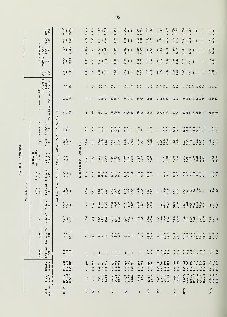
Table 1 lists the types of analysis used in the laboratories of theIllinois Geological Survey to obtain data for the field conference, as well as
those responsible for the analyses. The laboratory data are summarized intable 2 and illustrated in figure 3.
Description of Rock-Stratigraphic Units
The following rock-stratigraphic units have been, or are, in the pro-cess of being formally defined and described in detail (Ford, in preparation',Jacobs and Lineback, 19&9 ; Johnson, 196U and 1971; Johnson, Gross, and Moran(in press); and Willman and Frye, 1970). This discussion briefly summarizesthese descriptions and puts the units in a stratigraphic framework for refer-ence during the field conference. It includes only units that are pertinentto or will be observed during the conference (fig. 2).
Banner Formation
The Banner Formation consists of the glacial tills and intercalatedoutwash of sand, gravel, and silt deposited during the Kansan Stage in Illinoisand is bounded at the top by the Yarmouth Soil (Willman and Frye, 1970). Fivemembers of the Banner Formation have been defined in the Danville region, andalluvial sediments of Kansan or Yarmouthian age are included in the formation.
- 6 -
TABLE 1—ANALYTIC TECHNIQUES USED IN THE STUDY OF PLEISTOCENE DEPOSITS INEAST-CENTRAL ILLINOIS
Analyzed for Techniques Remarks Analyst
Grain-size distribution
( in unweathered
samples
)
Grain-size distribution
( in soil profiles
)
Clay minerals
Carbonates (calcite and
dolomite
)
Heavy minerals
Pollen
Inorganic carbon
Total carbon
Organic carbon
Total phosphorous
(p 2o5 )
Iron and manganese
Radiocarbon age
Till fabric
Sieving and hydrometer
Sieving and pipetting
X-ray diffraction of
oriented aggregates
Chittick apparatus
Sieving for 62 \i to
250 p. fraction; bromo-
form separation; grain
counts with polarizing
microscope
HC1, HP, KOH, silicone
oil
Sand: 0.062-2.0 mm
Silt: 0.004-0.062 mm
Clay: < 0.004 mm
Sand: 0.062-2.0 mm
Silt: 0.002-0.062 mm
Clay: < 0.002 mm
Clay fraction
< 0.002 mm
After Dreimanis
(1962)
100 transparent grains
per slide counted
Relative pollen
frequency
W. A. White and
assistants
W. A. White and
assistants
H. D. Glass
W. H. Johnson and
others
A. M. Jacobs
A. M. Jacobs
D. B. Heck
P. E. Gardner
CO2 absorption on LiOH
High-temperature combustion
Differentiation between total carbon and inorganic
carbon
HN0, extraction, precipitated by NHm complex D.B. Heck
Colorimetric determination on sodium dithionite D.B. Heck
(Na 2S20l|.) extract
Benzene liquid scintillation counting D. Coleman
Pebble orientation S. Smith
Lithology of pebbles
in tills
Pebbles embedded in plaster, sawed, identified S. Avcin
with binocular microscope A. M. Jacobs
- 7 -
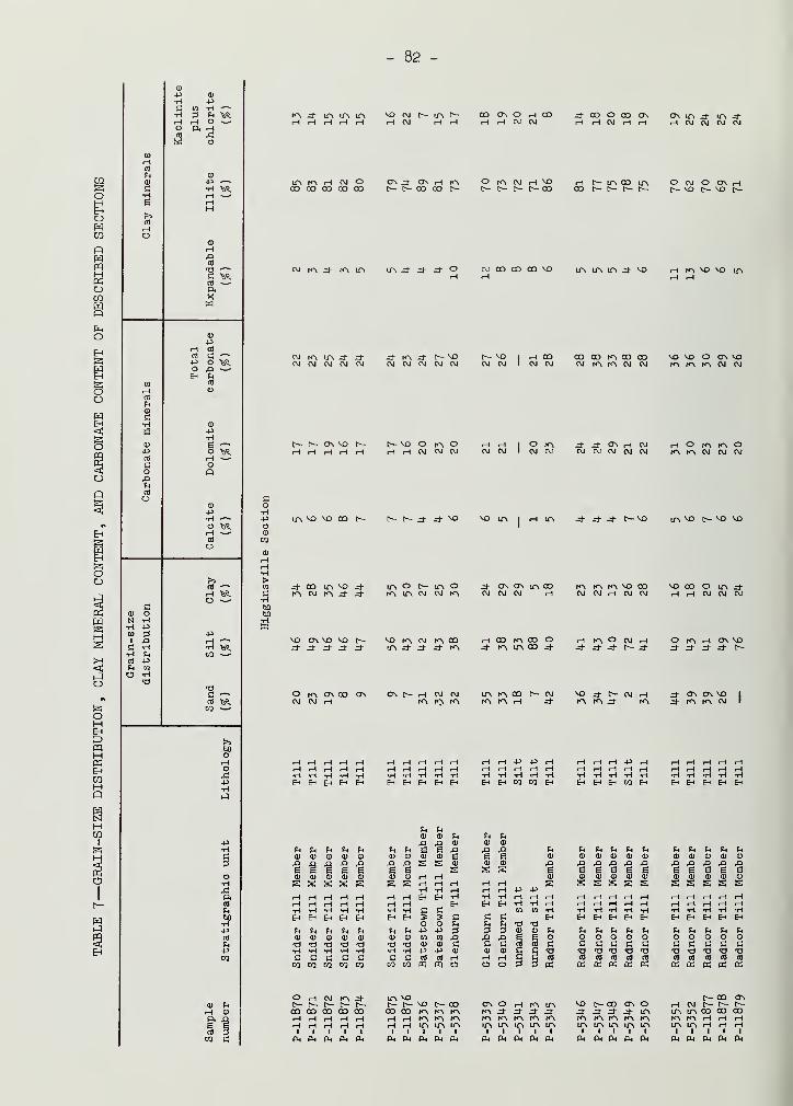
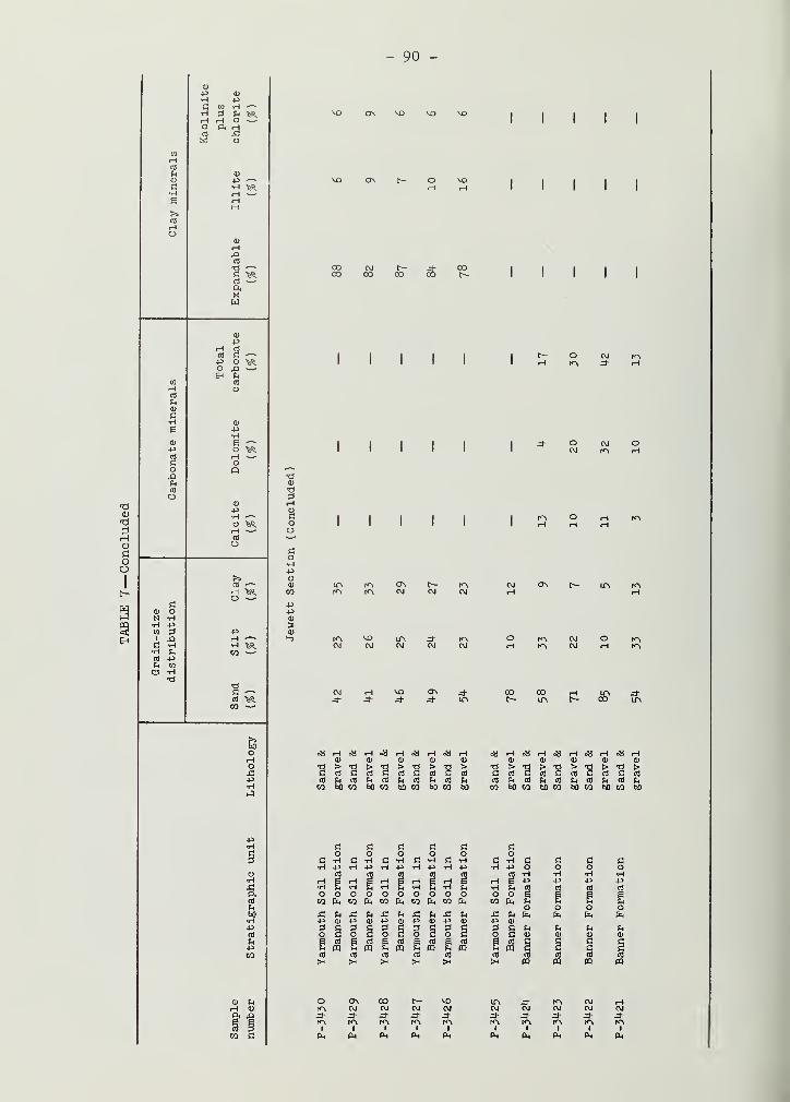
TABLE 2—GRAIN-SIZE DISTRIBUTION, CLAY MINERAL CONTENT, AND CARBONATE CONTENT INUNWEATHERED TILLS OF DESCRIBED SECTIONS
Grain-size
distribut Lon Clay minerals Carbonates
(* of < 2 mm) (* of ' < 2 p.) (# of < 74 p.)
Expandable Kaolinite
clay plus Total
Till member Sand Silt Clay mineral.s Illite chlorite Calcite Dolomite carbonate
SNIDER
mean 15 47 38 3 . 83 14 6 17 23
s.d.* 6 5 8 1 3 3 1 1 1
no. t 18 18 18 18 18 18 18 18 18
BATESTOWN
mean 28 38 34 3 79 18 5 19 24
s.d. 3 3 4 1 4 4 1 2 2
no. 23 23 23 24 24 24 24 24 24
GLENBURN
mean 34 42 25 13 64 24 5 18 23
s.d. 5 6 5 4 5 3 2 2 4
no. 30 30 30 25 25 25 30 30 30
OAKLAND
mean 18 46 36 22 53 25 3 11 14
s.d. 13 9 5 7 5 3 1 2 2
no. 9 9 9 9 9 9 9 9 9
RADNOR
mean 40 41 19 7 75 19 5 26 31
s.d. 5 2 5 3 6 5 1 3 4
no. 11 11 11 11 11 11 10 10 10
VANDALIA
mean 39 41 20 19 63 18 9 20 29
s.d. 7 7 4 11 11 4 2 4 5
no. ^9 49 49 46 46 46 38 38 38
SMITHBORO
mean 20 55 26 35 46 19 4 16 20
s.d. 6 8 4 13 12 3 1 3 4
no. 11 11 11 10 10 10 10 10 10
TILTON
mean 37 40 23 15 65 20 12 18 30
s.d. 5 7 4 5 6 2 2 2 4
no. 12 12 12 12 12 12 * 9 9 9
HILLERY
mean 31 41 29 8 71 22 13 13 26
s.d. 4 1 4 6 2 4 2 2 1
no. 4 4 4 4 4 4 4 4 4
HARMATTAN
mean 25 42 33 16 62 22 7 16 23
s.d. 6 10 5 10 8 3 2 5 6
no. 5 5 5 5 5 5 5 5 5
HEGELER*
mean 20 51 29 33 27 40 0.2 0.4 0.6
s.d. 5 5 5 4 3 4 0.2 0.2 0.4
no. 9 9 9 9 9 9 9 9 9
* Standard deviation; t number of samples; t data for Hegeler Till Member is from Johnson (1971)
- 8 -
Pig. 3 - Mean grain-size, clay mineral, and carbonate composition of tills in the
field trip areas.
- 9 -
Hegeler Till Member — The Hegeler Till Member is a greenish gray tillthat rests on bedrock and is overlain by the Belgium Member (Johnson, 19Tl) • Ithas been observed in only one area of the Harmattan Strip Mine , where it is upto 8 feet thick. The till is massive, silty, and contains many small, rounded,siliceous pebbles (table 3, fig. 3). The lower portion of the unit, however, alsocontains a large variety of crystalline pebbles derived from Precambrian rocksof the Canadian Shield.
The unit has a unique mineral composition for tills in Illinois. It
has a very low carbonate and illite content and a very high vermiculite and ex-pandable clay mineral content (table 2, fig. 3). The implications of the compo-sition on its origin and age have been discussed by Johnson (l9Tl)« He assignedthe Hegeler to the Kansan Stage hut suggested that it may belong to the Nebras-kan Stage. The regional extent of the unit is not known, but similar materialsresting on bedrock have been noted in a test pit for coal in west-central Illi-nois (A. M. Jacobs
, personal communication) and in a quarry in south-centralIllinois (I. E. Odom, personal communication). The unit will not be observedduring the field conference because it is no longer accessible.
Belgium Member — The Belgium Member consists of silt and clay thatoccur below the Harmattan Till Member and above the Hegeler Till Member, or,where the Hegeler is absent , above noncalcareous silt and colluvial depositson the bedrock (Johnson, 1971). The silt is tan to dark gray-brown, calcareous,fossiliferous , and locally carbonaceous. The upper part of the Belgium consistsof a thin brown clay which is faintly laminated and highly calcareous. The mol-luscan fauna (Leonard, Frye , and Johnson, 19Tl) consists predominantly of ter-restrial species and is indicative of a partially wooded terrain in a north-temperate climate. However, as the Belgium Member appears to have accumulatedin a lacustrine and/or alluvial environment in a broad, shallow bedrock valley,the fossils contained in the sediments were apparently washed into the valleybottom from surrounding slopes. The Belgium Member can be observed at Stop h,
Harmattan Strip Mine Section No. k (fig. 16)
.
Harmattan Till Member — The Harmattan Till Member is a gray to olive-gray till that occurs below the Hillery Till Member and above the Belgium Memberor bedrock (Johnson, Gross, and Moran, in press). The till is hard and massiveand varies considerably in texture and composition (table 2, fig. 3). Thesevariations appear to be primarily the result of deformation within the unit,which has resulted in the "stacking" of different types of till in various com-binations in a section.
The till is best known from exposures in the Harmattan Strip Minenear Danville. It has been observed in one other section in the Danville areaand tentative correlations have been suggested with till exposed in westernIndiana and in central Illinois (Johnson, Gross, and Moran, in press). The tilland related outwash can be observed at Stop h, Harmattan Strip Mine Section No. h
(figs. 16, IT).
Hillery Till Member — The Hillery Till Member is a distinct , reddishbrown till that stratigraphically occurs between two gray tills , the HarmattanTill Member below and the Tilton Till Member above (Johnson, Gross, and Moran,in press). It is best known in the Danville area and in most sections rests
- 10 -
a
si
8•H
ft
Cdpop
o
zqaBrtft
OJqqBQ
gqTUOUIT'T
aedsBp
aiqjBW
9qTzq.aBri.i$
qjgtjO
IBOO
9^BJ9UIOlSUO0
euoqspnw
9Uoq.sq.xxs
auoqspuBs
SIBlfS
gqxuioioa
guoqsgmx'T
W 13<H <L)
O rH P° s
o oS ft O
co•rl
PO<D
CO
rla>
£(U
e
I I I I I I I
I K^ K> I h"\ H I
LA N"\ K\ CO hO> rH VO
I
"I I I I I
I I I I
* ^I
I I I I I
MI
fOv I CT\ C~- MD rH CT\
CM CO CM CO O t—K"\ CM r-\ CM
I I I I I I
O
cdPPCT)
S
o
cdppcd
Bcd
I I I I
C7\ iPi
CM rHCM LT>CM CO
M3 r^
O rH MD t- M .=>- CT\^f- f^, ON rHK> CM fOi rH rH r-\ iHrH
I I
K> LPl Zd"
J-rHOOrOiCTNhOvVOrHLPvr^Ln
LACOCJNOO C\ ON .3- CM ON LT\• rH K\ CM rH
Os
PP
cd
aoAh
&r-i
cd
in
Sw
o
c
PPcd
cd
o
CcdpPcd
cd
pP£f-0
op•H
OCO
bO
•Hcd
Q
aoPM
cd
U
Sw
o
cflPpcd
cd
M
oa
cdPPcfl
gcfl
W
o
cflPPcd
cfl
CM
CMr^\
c— CTn r"\ CM LTl o CM ON =* rH r— o Lf\(^ l^v I*A rH r">\ =d- MA CM =t- CM CM CM CM
ppCD
<D
£ c o c •rl .
£ 3 £ cd cd Ph cfl P <<Ho O
u•H •rl O f>> p u <<H
u p P in rH rH £ c r! p c •HCD w W 9 O cd cd x; o cd rH cd -oO Q) c: a T) T3 p p i-H £? to c•rl P P •n fi a •rl rH i-H ^ bO C ^i
fi cd cd rH cd cd cd e •rl •rl cd cdCO pq PP C5 en > > co Eh K X W W
- 11 -
directly on bedrock. The till is very hard and massive, and it normally containsmore silt than sand or clay. It also has more calcite in the < 7^ y fractionthan all the other tills. It differs from the Tilton in color and in containingless dolomite in the < 7^ y fraction (table 2, fig. 3).
Although not "widely known, the Hillery has been observed in severallocalities in central and south-central Illinois and in western Indiana. Ittherefore appears to be a rather extensive, but discontinuous, rock unit. The
Hillery will be observed at Stop h, Harmattan Strip Mine Section No. k (figs.
l6 , 17), and at Stop 5, School House Branch Section of Hungry Hollow (figs. 18
,
19).
Tilton Till Member — The Tilton Till Member is a gray to brownishgray till that occurs above the Hillery Till Member. It is overlain by alluvialsediments of the Banner Formation, the Smithboro or Vandalia Till Members of theGlasford Formation, or a younger unit. It is the Vandalia Till that generallyoverlies it in the Danville area. The Tilton Till contains a weathered zone inthe upper portion in two sections near Danville, and in other sections the upperpart of the till is often oxidized. Outwash related to the till is rather com-mon in many sections, and the till contains more sand and silt than clay in the< 2 mm fraction. The Tilton is somewhat similar to the Vandalia Till but has a
higher calcite content in the < 7^ y fraction (table 2, fig. 3).
The Tilton Till Member is thought to be stratigraphically equivalentto till that has been called "eastern Kansan" or "Kansan" in eastern and centralIllinois in the past decade (Willman, Glass, and Frye , 1963; Johnson, 196^; andJacobs and Lineback, 1969). The Tilton Till will be observed at Stop 3, EmeraldPond Section (figs. lk 9 15), at Stop k t Harmattan Strip Mine Section No. k (figs.
l6, 17) , and at Stop 5, School House Branch Section of Hungry Hollow (figs. 18
,
19).
Unnamed sediments of the Banner Formation — Sediments in two differ-ent stratigraphic positions are included as portions of the Banner Formation.Silts below the Belgium Member and above the local bedrock that were describedby Johnson (1971) were exposed near the base of the Harmattan Strip Mine Sec-tion No. h (Stop h) . That part of the section is now under water. Sediments,apparently of alluvial origin, that lie above the Tilton Till Member in theSchool House Branch Section of Hungry Hollow (Stop 5) are probably of Yarmouth-ian age and are later discussed in more detail in the introduction to Stop 5-
Petersburg Silt
The Petersburg Silt was named by Willman, Glass, and Frye in 1963, andthe unit was later classified as a formation (Willman and Frye, 1970). It ispredominantly silt, often of loessial origin, that was laid down as a proglacialdeposit in the early part of the Illinoian Stage. A thin silt below the Smith-boro Till Member in the School House Branch Section of Hungry Hollow (Stop 5)was included in the Petersburg Silt (Johnson, Gross, and Moran, in press). Be-cause this silt is partly weathered (see discussion for Stop 5), it may be some-what older than the Petersburg Silt in the type section, which is calcareous andgenerally unweathered. For this reason we have concluded that it is better in-cluded in the Banner Formation.
- 12 -
Glasford Formation
The Glasford Formation consists of the glacial tills and intercalatedoutwash of sand, gravel, and silt deposited in Illinois during the IllinoianStage (Willman and Frye , 1970). Seven members of the Glasford Formation havebeen defined or identified in south-central and east-central Illinois, five ofwhich "will be seen on the field trip.
Smithboro Till Member — The Smithboro Till Member is a silty tillthat lies below the Mulberry Grove Member or Vandalia Till Member and rests onthe Petersburg Silt or on till or outwash of the Banner Formation (Jacobs andLineback , 1969; Willman and Frye, 1970). The type section is in south-centralIllinois , and till in the Danville region has been correlated with the Smith-boro on the basis of strong similarities in texture and composition (Johnson,Gross, and Moran, in press). In addition to being silty, the Smithboro con-tains less carbonate in the < 'jk \i fraction than most of the other tills , andthe clay fraction contains the largest quantity of expandable clay minerals(table 2, fig. 3). Wood and mollusk shells in the till, along with its composi-tion, suggest that the glacier that deposited the till incorporated large quanti-ties of Petersburg Silt.
The Smithboro is widespread in southeastern and eastern Illinois andhas been observed in western Indiana. It will be seen at Stop 5, School HouseBranch Section of Hungry Hollow (figs. 18 , 19), at Stop 7, Hutton Section (figs.
23, 2k) , and at Stop 8, Jewett Section (fig. 25).
Mulberry Grove Silt Member — The Mulberry Grove Silt Member includessilt and related sediments that lie between the Smithboro and Vandalia TillMembers (Jacobs and Lineback, 1969; Willman and Frye, 1970). It is a thin,lenticular deposit that is generally calcareous and locally carbonaceous. Inthe Danville region, some of the sediments that have been included in the unitare colluvial in origin and are noncalcareous . The Mulberry Grove Silt Memberwill be observed at Stop 5, School House Branch Section of Hungry Hollow (fig.
Vandalia Till Member — The Vandalia Till Member is the surficial tillin large areas of southeastern and south-central Illinois. It was named anddefined by Jacobs and Lineback in 1969 and was later made a formal member of theGlasford Formation by Willman and Frye (1970). In most places it overlies theMulberry Grove or Smithboro Members or the Banner Formation and is overlain byeither younger Illinoian sediments (Roby Silt or Radnor Till Members) or Wiscon-sinan sediments (Roxana Silt or Wedron Formation).
The Vandalia till is brown to brownish gray and is generally coarserthan the other tills in this part of Illinois. It contains considerable inter-bedded sand, gravel, and silt. The till can be recognized by its high sand con-tent in the < 2 mm fraction and its relatively high calcite content in the < 7^ Vfraction (table 2, fig. 3). The unit will be observed at Stop 1, HigginsvilleSection (figs. 8, 9), at Stop k , Harmattan Strip Mine Section No. k (figs. 16,
17), at Stop 5, School House Branch Section of Hungry Hollow (figs. 18, 19), at
Stop 6, Center School Section (figs. 21, 22), at Stop 7, Hutton Section (figs.
23, 2k) , and at Stop 8, Jewett Section (figs. 25, 26).
- 13 -
Roby Silt Member — The Roby Silt Member includes silts and relatedsediments that lie "between the Vandalia and Radnor Till Members (Johnson, 196U;Willman and Frye, 1970). As originally defined, the unit included only relatedsediments deposited in a lake, or perhaps a series of lakes, in central Illi-nois, but the unit is here extended to include similar deposits in the same
stratigraphic position in eastern Illinois. In the Danville area, the RobySilt Member has been described from Harmattan Strip Mine Section No. 3 (Leonard,Frye, and Johnson, 1971) and will be observed at Stop 1, Higginsville Section(fig. 8). In the Danville area, the Roby is predominantly silt that is calcar-eous and locally fossiliferous and carbonaceous.
Wood from the unit in Harmattan Strip Mine Section No. 3 yielded a
radiocarbon date of > U7 ,000 years B.P. (ISGS-29). The molluscan fauna fromthat section has been described (Leonard, Frye, and Johnson, 1971), and thefauna from the Higginsville Section is listed and explained in the discussionof that section.
Radnor Till Member — The Radnor Till Member was named and defined byWillman and Frye (1970) to include a gray, silty till in central Illinois thatoverlies the Toulon Member, the upper part of which is strati graphically equiv-alent to the Roby. The Radnor Till is bounded at the top by the Sangamon Soil.The till and related sediments were deposited during the last recognized Illi-noian glaciation in Illinois. The unit is here extended to eastern Illinois toinclude till and related outwash in the same stratigraphic position that is sim-ilar in composition. The Radnor in the Danville area varies somewhat and in
places contains more sand and less silt than the Radnor in the type area. As
more data on its character and distribution become available, it may eventuallybe appropriate to establish it as a new rock unit in eastern Illinois, but thisdoes not seem necessary at the present time.
Although it was not definitely recognized, the existence of this tillin the Danville area was suggested by Johnson, Gross, and Moran {in press) onthe basis of laboratory data. Further field studies have documented its pres-ence in the area, and in the Higginsville Section it is separated from theVandalia by the Roby Silt Member. The unoxidized till varies from light todark gray and varies somewhat in texture, but it generally contains from 30 tokO percent sand in the < 2 mm fraction. It is distinguished from the VandaliaTill by containing less calcite and more dolomite in the < 7^ y fraction andmore illite in the clay fraction (table 2, fig. 3). Interbedded silt and sandare common in some sections, in the Higginsville, for example. This interbed-ding and the presence of structures that may be of collapse origin in the samesections suggest that both superglacial and ice-contact deposition may havetaken place. The till is rather common in sections north of Danville, but ithas not been observed to the south. Central Vermilion County is apparentlythe southern limit of the late Illinoian advance. The unit will be observedat Stop 1, Higginsville Section (figs. 8, 9), at Stop 2b, Collison Branch Sec-tion No. 2 (figs. 10, ll), and at Stop U, Harmattan Strip Mine Section No. k
(figs. 16, 17).
Pearl Formation
The Pearl Formation consists of sand and gravel that has the SangamonSoil in its top ( Willman and Frye, 1970). It is largely a pebbly sand that was
- Ik -
deposited as outwash overlying or extending beyond the Illinoian till. Materi-als included in the Pearl Formation will be observed at Stop 6, Center SchoolSection (figs. 21, 22). In that section the Sangamon Soil is developed in thePearl, and it is difficult to interpret the origin of the parent materials be-cause of subsequent modification by pedogenic processes.
Unnamed Silt
A thin carbonaceous silt, which has yielded a radiocarbon date ofU8,000 ± 1,700 years B.P. (lSGS-63), is exposed in the Higginsville Section(Stop 1, fig. 8). The date suggests an Altonian age for the silt, but thestratigraphic situation is not clear, and for this reason no formal strati-graphic designation is made at this time. Pollen and other data, as well as
problems of interpretation of the silt, are described and discussed in the ex-planation of the Higginsville Section.
Roxana Silt
The Roxana Silt is largely silt of loessial origin, but it also in-cludes some windblown sand and some sand, silt, and clay of colluvial origin(Frye and Willman, i960 ; Willman and Frye , 1970 ) . It rests on the SangamonSoil and is bounded at the top by the Robein Silt or the Farmdale Soil. TheRoxana is thickest and best developed in western and west-central Illinois ,
where it has been subdivided into three formal members and where several soilshave been recognized in it (Willman and Frye, 1970).
Silt and colluvium in the Collison Branch Section No. 2 (Stop 2b,figs. 12, 13) above the Radnor Till that are weathered and are part of thepaleosol in the section are included as a portion of the Roxana Silt. Thestratigraphic and pedologic situation is discussed further in the explanationfor that section. These materials may be older than typical Roxana Silt, butthe Roxana is the only appropriate rock unit currently available to which thematerials can be assigned.
Roxana Silt, sandy silt fades — In eastern Illinois, a sandy silt,which occurs in the stratigraphic position of the Roxana, is included as a
facies of the Roxana Silt. The materials, their stratigraphic relations, andtheir origin are discussed in more detail on p. 25-27 and in the explanation of
the Center School Section, Stop 6, where the facies will be observed (fig. 2l)
.
It will also be seen at Stop 7, Hutton Section (figs. 23, 2H) , and at Stop 8,
Jewett Section (figs. 25, 26).
Robein Silt
The Robein Silt includes carbonaceous silt, sandy silt, and peatand rests on the Roxana Silt or on an older unit; it is usually overlain bythe Peoria Loess, the Morton Loess, or the Wedron Formation (Willman and Frye,
1970). The Robein is a thin but widespread and distinctive deposit that ac-
cumulated immediately prior to the advance of the Woodfordian glaciers in Illi-nois. It has been radiocarbon dated in many localities in Illinois and is for
the most part Farmdalian in age. Recent dates in south-central Illinois, how-
ever, indicate that the unit in that area is of early Woodfordian age, which
- 15 -
makes the top of the unit time transgressive (Kempt on and Gross, 1971). The
Robein will be observed at Stop k, Harmattan Strip Mine Section No. k (figs.
16, 17), and at Stop 6, Center School Section (figs. 21, 22).
Wedron Formation
The Wedron Formation consists of the glacial tills and intercalated
outwash of sand, gravel, and silt deposited in Illinois during the WoodfordianSubstage of the Wisconsinan Stage (Frye et al. , 1968; Willman and Frye , 1970).
The formation extends from the basal contact with the Morton Loess or an older
unit to the top of the till below the Two Creek deposits at Two Creeks , Wis-
consin. In east-central Illinois, four members of the Wedron Formation have
been formally defined.
Oakland Till Member — The basal Woodfordian till in eastern Illinois
was named Oakland by Ford (in preparation) . In the type area it is a brown tobrownish gray till that overlies the Robein Silt and is overlain by the Glen-
burn Till Member. It is characterized by relatively large amounts of expandable
clay minerals in the clay fraction and by a low carbonate content (table 2, fig.
3) . The till is not as continuous as the overlying Glenburn Till and is nowknown from only one exposure in the Danville area. Till of the same type has,
however, been described in several borings farther west (Kempton, DuMontelle
,
and Glass, in press). Because of its sporadic distribution, Ford interpretedit as being of local origin and suggested it was the result of the same ice
advance as the Glenburn Till. The Oakland will be observed at Stop h, Harmat-tan Strip Mine Section No. h (figs. l6 , 17).
Glenburn Till Member — The Glenburn Till Member is a brownish gray
to reddish brown till that lies between the Oakland Till Member or an olderunit and the overlying Batestown Till Member (Johnson, Gross, and Moran, in
press) . The Glenburn varies from a rather distinctly pink till to one that
is more gray-brown but oxidizes to a pink color. It is sandier and containsless illite in the clay fraction than the overlying Batestown Till, and it
contains less calcite in the < 7^- y fraction than the Vandalia Till (table 2,fig. 3). Although absent from several sections in the Danville region, the
till is extensive in the Decatur Sublobe. To the west, similar till has beennoted in the subsurface in the Champaign-Urbana area (Kempton, DuMontelle,and Glass , in press) , has been observed in exposures along the Sangamon Rivernear Mahomet, and appears in several borrow pits along Interstate "jh betweenMahomet and Bloomington. To the south, it eventually becomes the surficialtill beyond the margin of the Batestown Till and extends to the area of theShelbyville Moraine (fig. h) . Thus it appears to have been deposited by the
most extensive advance of the Woodfordian glacier in eastern Illinois. Tworadiocarbon dates (see discussion in explanations of Higginsville and EmeraldPond Sections) from the Danville area suggest that the Glenburn might be olderthan the Woodfordian. Our interpretation that it is Woodfordian is based onthe presence of the Glenburn above the Robein Silt in several sections in thispart of Illinois. The Glenburn will be observed at Stop 1, Higginsville Sec-tion (figs. 8, 9), at Stop 2a, Collison Branch Section No. 1 (figs. 10, ll)
,
at Stop 3, Emerald Pond Section (figs. lU, 15), at Stop U, Harmattan StripMine Section No. h (figs. 16 , 17), and at Stop 6, Center School Section (figs.
21, 22).
- 16 -
p ie 4 - Areal distribution of the dominantly till formations and members of Illinois. West-
S*
ern and northern Illinois from Willman and Frye (1970). Mapping in eastern and south-
rn Illinois based on work in progress and subject to change; Glasford Formation by
L. R. Follmer, A. M. Jacobs, J. A. Lineback, R. M. Mason; Wedron Formatxon by J. P.
Ford, W. H. Johnson, J. P. Kempton, and J. A. Lineback.
- IT -
Batestown Till Member — The Batestown Till Member is a gray, oftensilty till that occurs stratigraphically "bet-ween the Snider and Glenburn TillMembers in the Danville region (Johnson, Gross, and Moran , in press). It is
the surficial till beyond the margin of the Snider Till at the frontal edge
of the Illiana Morainic System and extends southward to the northern part of
Coles County (Ford, in preparation) (fig. h) . The Batestown oxidizes to a
rather characteristic light olive-brown. It is a coarser till than the over-
lying Snider; both have a high illite content (table 2, fig. 3).
The Batestown appears to "be equivalent to the upper of two gray-
tills reported in the Champaign-Urbana area (Kempton, DuMontelle , and Glass,
in press). However, a lower zone that has "been observed within the Batestownin the Danville region may be equivalent to the lower of these gray tills
.
The Batestown will be observed at Stop 1, Higginsville Section (figs. 8, 9),at Stop 2a, Collison Branch Section No. 1 (figs. 10, ll) , at Stop 3, EmeraldPond Section (figs. lU , 15), and at Stop h, Harmattan Strip Mine Section No. k
(figs. 16, 17).
Snider Till Member — The Snider Till Member is a gray, silty andclayey till that lies stratigraphically above the Batestown Till and is thesurficial till in and north of the Illiana Morainic System (Johnson, Gross,and Moran, in press). The till is characterized by a coarse, blocky structure,and secondary calcium carbonate concentrations are common in the joints justbelow the leached zone of the Modern Soil developed in the top of the till.
Although it varies somewhat, the till's most diagnostic characteris-tic is its fine-grained texture. The sand content in the < 2 mm fraction variesfrom less than 5% in extreme northwestern Vermilion County to over 20% in rarelocalities near Danville. This variation in texture was noted by Wascher andWinters (1938) while they were mapping the soils of the county. Vertical vari-ations in texture within the till also have been observed in some sections, butthese variations appear to be either gradational or local and seem to have noregional stratigraphic significance. The fine-grained texture of the Sniderprobably reflects erosion and incorporation of lacustrine silts and clays bythe glacier that deposited the till. The lacustrine sediments apparently ac-cumulated during the time of ice withdrawal following the deposition of theBatestown Till. The Snider Till Member will be observed at Stop 1, Higgins-ville Section (figs. 8, 9), at Stops 2a and 2b, Collison Branch Sections 1 and2 (figs. 10, 11, 12, 13), and at Stop 3, Emerald Pond Section (figs. lU, 15).
Peoria Loess, Morton Loess, Richland Loess
The widespread loessial silt that was deposited during the Woodford-ian Substage is included in one of three formations , depending on the strati-graphic position (Frye and Willman, i960). The loess that accumulated on theIllinoian drift plain beyond the margin of the Wedron Formation is called thePeoria Loess. It generally overlies the Farmdale Soil developed in the Roxanaor Robein Silts. The Peoria Loess will be observed at Stop 7, Hutton Section(figs. 23, 2k) , and at Stop 8, Jewett Section (figs. 25, 26).
The loess that was buried by the Wedron Formation is called the Mor-ton Loess , and the loess that was deposited on top of the Wedron Formation is
called the Richland Loess. The. Morton will not be observed on the field trip.
- 18 -
Relatively thin Richland Loess will he observed at Stop 1, Higginsville Sec-tion (fig. 8), at Stop 3, Emerald Pond Section (fig. lU) , at Stop k , Harmat-tan Strip Mine Section No. h (fig. 16) , at Stop 5, School House Branch Sectionof Hungry Hollow (fig. 18) , and at Stop 6, Center School Section (fig. 21)
.
Henry Formation
The Henry Formation includes sandy and gravelly outwash of Wiscon-sinan age that is overlain only by the Richland Loess or other post-WedronFormations (Willman and Frye , 1970).
Batavia Member — The Batavia Member includes the surficial sand andgravel deposits that lie on the upland areas and were deposited primarily alongthe fronts of moraines as outwash plains. The Batavia Member will be observedat Stop U, Harmattan Strip Mine Section No. h (fig. l6) , where outwash relatedto the Illiana Morainic System is exposed.
Description of Soil-Stratigraphic Units
The following soil-stratigraphic units have been identified in thefield trip area by regional correlation. The following discussion places the
paleosols in a stratigraphic framework, and the physical characteristics ofthe soils that will be observed on the field trip are included in the discus-sions of the field trip stops.
Yarmouth Soil
The soil developed in the uppermost part of the Banner Formation (Stop
5, School House Branch Section of Hungry Hollow, fig. 18 ; Stop 8, Jewett Sec-tion, fig. 25) is in the proper stratigraphic position to be the Yarmouth Soil.
The soil is overlain by the Smithboro Till Member, the oldest Illinoian till(Liman Substage) at present known in eastern Illinois. The soil is developedin till or related sediments that occupy the same stratigraphic position as
till in western Illinois that contains a soil that has been correlated across
the Mississippi River to the area of the type Yarmouth Soil in Iowa (Willmanand Frye, 1970)
.
Pike Soil (?)
The Pike Soil was named and defined by Willman and Frye (1970). The
type section is located in western Illinois, where the soil is generally de-
veloped in the Kellerville Till Member of the Glasford Formation and overlain
by the Duncan Mills Member or the Hulick Till Member of the Glasford Formationor by the Teneriffe Silt. A weak soil developed in sediments between the Smith-boro and Vandalia Till Members of the Glasford Formation in the School House
Branch Section of Hungry Hollow (Stop 5) (fig. 18) is tentatively correlatedwith the Pike Soil because the Smithboro is probably correlative with the Kel-lerville, and the Vandalia with the Hulick. Although poorly exposed, materialsthat are part of this same soil are present at Stop 7 S
Hutton Section (figs.
23, 2^). The soil is not known in other sections in eastern Illinois, and no
- 19 -
firm correlation of the stratigraphic sequence in eastern Illinois with thatin western Illinois has been made.
Sangamon Soil
The Sangamon Soil was named by Leverett in 1898 for a soil in the tillof Illinoian age that lies immediately below Wisconsinan deposits in SangamonCounty in central Illinois. Willman and Frye (1970) recently established para-types for the Sangamon Soil in and near Sangamon County, where the soil is oftendeveloped in the till of the middle Illinoian (Monican Substage) and is overlainby the Roxana Silt. The Sangamon is a widely recognized soil in the Midconti-nent region, and paleosols exposed in the Center School (fig. 2l) , Hutton (fig.
23) » and Jewett Sections (fig. 25) (Stops 6, T s 8) are easily correlated withthe Sangamon Soil of the type area.
The situation in the Danville region is not so clear. Johnson, Gross,and Moran (in press) reported that, because of extensive erosion, there was es-
sentially no evidence of the Sangamon Soil in the sections they studied. A newlydiscovered exposure (Stop 2b, Collison Branch Section No. 2, fig. 12), however,does contain a truncated soil profile, the lower part of which is developed in
the Radnor Till Member of the late Illinoian (jubileean Substage). The upperpart of the soil, however, is developed in material that is younger in age andappears to be colluvial or alluvial in origin. Although the upper material is
definitely not loessial in origin, it is tentatively included in the Roxana Silt,and only the lower part of the profile is considered part of the Sangamon Soil.
The problems of interpretation of the soil are considered further in the discus-sion of Collison Branch Section No. 2 (Stop 2b).
Farmdale Soil
The widespread and distinctive Farmdale Soil was formally named byWillman and Frye (1970) to include the peaty and carbonaceous deposits of theRobein Silt and the moderate to better drained profiles developed in RoxanaSilt. The soil is usually overlain by the Morton or Peoria Loess or by theWedron Formation. In addition to the upper part of the soil at Stop 2b, theCollison Branch Section No. 2, described in the preceding paragraph, the Farm-dale Soil will be observed at Stop 6, the Center School Section (fig. 2l) , StopT, Hutton Section (fig. 23), and Stop 8, Jewett Section (fig. 25).
STRATIGRAPHY OF THE DANVILLE REGION
The Pleistocene stratigraphy of the Danville region was recently con-sidered and re-evaluated by Johnson, Gross, and Moran (in press). With the ex-ception of the Belgium Member of the Banner Formation, the Roby Silt and RadnorTill Members of the Glasford Formation, the Robein Silt, and the Oakland andGlenburn Till Members of the Wedron Formation, all of the stratigraphic unitsdescribed in the preceding section and currently recognized in the Danvillearea had been described and reported earlier by Eveland (1952) or by Ekblaw andWillman (1955). The interpretation of the units, however, is considerably dif-ferent. In the two earlier reports, the ages of the stratigraphic units were
- 20 -
Approximate
elevation
(ft)
Hlgglnsville Section
Riohland
Loess
Riohland Loess
Roby Silt Member
Fr"r":-~^| siit
HSl ""
If f FT II Soil profile
F^^ Shale
Approximate
elevation
(ft)
Harmattan Strip Mine
Section No. 3
Richland Loess
Henry Formation
Radnor Till Kbr.
LRoby Silt Kir.
Vandal iaTill Member
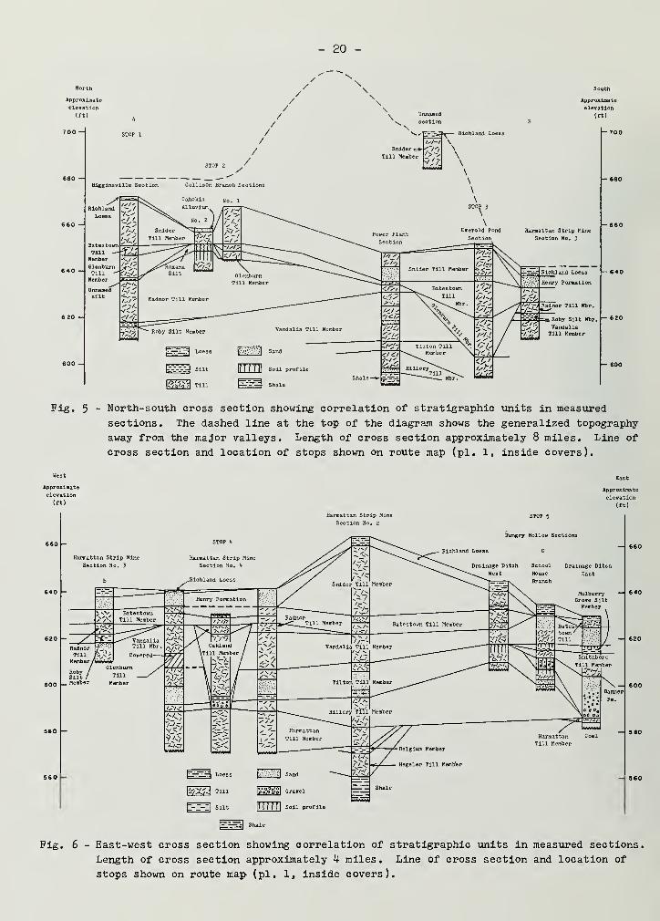
Pig. 5 - North-south cross section showing correlation of stratigraphic units in measured
sections. The dashed line at the top of the diagram shows the generalized topography
away from the major valleys. Length of cross section approximately 8 miles. Line of
cross section and location of stops shown on route map (pi. 1, inside covers).
Approximate
elevation
(ft)
Approximate
elevation
(ft)
620 - X
Harmattan Strip Mine
Section No. 2
Harmattan Strip Mine
Section No, 3
STOP 5
Hungry Hollow Sections
Richland Loess
RobySilt i
600 I— Member
School
House
Branch
Drainage Ditch
East
Mulberry —I 640Grove Silt
Membe
&m Loess
\®tf4 Till
t---:| Silt
(zlS)
IT T 7 T f 1Soil profile
Shale
Fig. 6 - East-west cross section showing correlation of stratigraphic units in measured sections.
Length of cross section approximately 4- miles. Line of cross section and location of
stops shown on route map (pi. 1, inside covers).
- 21 -
based on the interpretation of two weathered zones in the Drainage Ditch Sec-
tion and School House Branch Section of Hungry Hollow. Eveland interpretedthe two soils as the Sangamon and Yarmouth Soils, respectively. Ekblaw and
Willman interpreted the lower and most developed as the Sangamon Soil and the
upper as having formed during a period of colluviation and weathering in the
Wisconsinan. (in current terminology, it would most likely be the Farmdale
Soil.) The tills above the Sangamon Soil were related by Ekblaw and Willman
(1955) to end moraines south of Danville or called Farmdale (Altonian in the
current terminology) , and the lower tills were called Illinoian by Ekblaw and
Willman or Kans an by Eveland.
Our approach has been to base the ages of the stratigraphic unitson correlations with stratigraphic units of known age elsewhere in Illinois(Johnson, Gross, and Moran, in press). We established Illinoian age by cor-relation with units in the Illinoian type area, Kansan age by correlation withunits in southern and central Illinois that have long been recognized as Kan-san, and Wisconsinan age by determination of stratigraphic position in rela-tion to the Robein Silt. Radiocarbon dates helped to establish Woodfordianage for some units.
The soils were classified according to their position in the strati-graphic sequence: the truncated soil developed in the youngest Illinoian tillis the Sangamon, the weak soil developed in materials between the middle andoldest Illinoian tills is the Pike, and the soil developed in the youngestKansan till is the Yarmouth. Our interpretation is off one stage from theearlier interpretation of Ekblaw and Willman. The soil they considered to bethe Sangamon we consider the Yarmouth, and the "soil" they considered to bewithin the Wisconsinan we consider to be the Pike Soil, which is within theIllinoian.
Figures 5 and 6 are north-south and east-west cross sections , re-spectively, which show the correlation of the Danville sections that will beobserved during the field conference. A few other measured sections appear infigures 5 and 6 to show the stratigraphy in more detail. The stratigraphic situa-tion is complex because of the multiple episodes of glaciation and associatederosion and/or deposition by the ice. Weathering and fluvial erosion during inter^glacial periods added to the complexity. Consequently, most of the record ofweathering has been lost, and in most sections no paleosols are preserved.For the same reasons , several of the tills are no longer continuous units ,
being preserved only locally in favorable positions , such as former alluvialvalleys. In view of the magnitude of erosion for which there is documenta-tion, it is remarkable that the stratigraphic record in the area is so com-plete. Although the Altonian is not well represented, the record of the Kan-san, the Illinoian, and the Woodfordian at Danville is probably as complete asany in the Midcontinent region.
The glacial tills in Illinois have been related to source areas andto particular glacial lobes on the basis of geographic location and distribu-tion, configuration of end moraines, till fabric, and mineral composition.The tills in the eastern part of the state have generally been referred tothe Lake Michigan Lobe, the Saginaw Lobe, or the Erie Lobe. However, becauseworkers have used various criteria, there is a lack of agreement among themconcerning the lobe source of some of the tills.
- 22 -
Table k summarizes the lobe sources or ice movement directions sug-
gested for the tills in the eastern part of the state by recent workers. They
have more or less agreed on the pre-Wis cons in an tills, but not on the Woodford-ian tills. Willman and Frye (1970) considered the Decatur Sublobe to be part
of the Erie Lobe, on the basis of their interpretation of the Gibson City re-
entrant as being the result of interference between the Peoria Sublobe of the
Lake Michigan Lobe and the Decatur Sublobe of the Erie Lobe. Their interpreta-tion would make the surficial Woodfordian tills in east-central Illinois the
result of glaciation by the Erie Lobe. Johnson, Gross, and Moran (in press),however, noting the predominance of dolomite over calcite in these tills (table
2), related them to the Lake Michigan Lobe, reasoning that the high dolomitecontent reflected the dolomitic bedrock (Silurian) around the southern periph-ery of Lake Michigan.
Heavy minerals have proved useful in determining the source area oftills in Illinois, and Willman, Glass, and Frye (1963) reported that the garnetand epidote contents are particularly diagnostic. The tills deposited by the
Lake Michigan Lobe generally have about equal amounts of garnet and epidote,whereas tills derived from a more easterly source contain much larger amounts
of garnet than epidote. Although no systematic study of the heavy minerals in
the tills in the field trip area has been made, a few samples from each unitwere analyzed to obtain data for the field trip (tables 5,6). Unfortunately,the data are limited and are not in good agreement with the results reportedby Willman, Glass, and Frye (1963) for a few samples in the Danville area.Consequently, at the present time no interpretations regarding source areascan be made from heavy mineral data.
Willman and Frye (1970) suggested that the drift of the IHi ana Mor-ainic System (Decatur Sublobe) is younger but apparently close in age to thedrift of the Bloomington Morainic System (Peoria Sublobe). This interpreta-tion is based primarily on topographic relations in the area of the Gibson Cityre-entrant. Subsurface work on the tills in McLean County ( Peoria Sublobe) andin Champaign-Urbana (Decatur Sublobe) by Kempton, DuMontelle, and Glass (in
press), based on lithologic correlations between tills in the two sublobes, sug-
gests significantly different age relations. Major problems in the area, there-
fore, include working out relations between the Decatur and Peoria Sublobes andin determining the source lobes for the tills.
STRATIGRAPHY OF SOUTH-CENTRAL AND SOUTHEASTERN ILLINOIS
Recent work on the Pleistocene deposits in south-central and south-eastern Illinois includes studies by Jacobs and Lineback (1969), Follmer (1970),and Ford (in preparation).
The stratigraphic framework of the Illinoian and older deposits wasestablished by Jacobs and Lineback (1969) in the Vandalia region. They showedthat there were two widespread and distinct Illinoian tills, the Smithboro andthe Vandalia, which had been deposited by different glacial advances. In addi-tion, they demonstrated that a thin silt, the Mulberry Grove Silt Member, hadbeen deposited during the time of deglaciation between the Smithboro and Van-dalia advances , that the glacier that deposited the Vandalia Till had undergonewidespread stagnation, and that a variety of well sorted to partly sorted sedi-ments had been deposited over the Vandalia Till during wasting of the ice.
- 23 -
rH<<H iHO •H
*—» >o O Ct- •H nion Ph Pf-l X!
oJ ni•k <H x! a;
XI -P up a ni
c •H o Cl
o e •H•H co d-P »—
*
a; to
o W rHcd c-1
U PQ •H•H PdPG
e^_^
> to <(H
o to
<1)
in
ft
O to
i o1 tH
x: o(D •H -P £O !h 3 -HH
•H
Xi O rHcfl tO H<lH H
K Gi! a •r) rH
o nioni
to fn
xi
C•H
da)
rH -PrH £
to •Hai P O
1-3m
"-'
>»1 >» bO
-3 C a) ofl s o rH H to
OJ ni o o ni rH^ ni
•> rH O o >» Ph
to rH f- •H aj
to •H ON a ?H •H fi
ni 13 rH ni 1 fi -HrH fn M ses >* * O CD
KN S « •P >JM M3 >> fl ni >
rt ON U £ o C ni
OJ r-t fn o •h O CD
g p X! XIH * rrj 3 ni fn
H <D C a> ?H ni -dr) t»s aJ to 3 o a|3 Ph aj bo ni
Ph m •rH
<1H
>d
ni
O!h
3oto
,_^
-Px> "3 xio Pi CD bOi-3 n)
to
-P -Hni CD
ft to £ 310 a) o10 fn Q >»O ft ^ X!in ni
tis
•HO ^.
* £C » o !>>
o c toto nj *d ofl in CD rHX! o to cx!
o g cd Uh> pq cd
•H
-p•HGfS
HrH•HEH
Co•H-PniPaCD•rH
Pi -pO
T) SCD &Ph +5 -H-
Ph 3 H^CD o ca
<<H 10 CD
CD 1 SPh •S i5ft -p -p
s 3o o ois w CO
-ptoCD
SZp?5Oco
(0 10 •pni CD toCD 5 CD
X3 X! S-P p x!3 pi po O 310 to
1
oto
XJ Xi 1p •p p3o §
toCD
CO CO ^
CD CD
3 3x: X!p •p
3 p so to oto
1
niCD
to
1
x: X! XI-p •p -p3 P! ^o o oCO co CO
3ni
•)- 4- 4- CCD CD CD CD •H CD
•H •H •H •H to •Hu Ph Ph Ph n! Ph
w W W W CO W
a C a S C C £ni ni nj ctf ni ni ni
bO &0 bO bO bO bO bo•iH •H •H •H •H •H •Hx! x! x! x: XJ x| X|o o o o O o o•H •H •H •H •H 3 •H •HS S s S s ni
d•H
S sCD CD CD CD CD CD CD CD CD
>i ^! ^ X i! bO ^1 •H •rl ^m n) ni ni ni ni n) Ph Ph ni
dO Ph
Ph •P Pi
CD to XIT) CD £•H -P a>
fl ni HCO m C5
scd
ni
O
Ph
oa-dnj
ni
•HrHni
dfini
>
OPhO
•H6CO
o-prH•HEh
Ph
CD
•H
ni
P•Pni
ni
Ph
CD
rHCD
bOCD
M
CD
X!O^CD
•HPh
WCD
X!-P
X!
dCD-p•HtooftCD
dCD
uCD
3
CD
X!orH
CO
•H10
nj-PaJ
d3
s
o
dCD
COa3
XI
Pio•HPoJ
-P <1h
cd -dPh
ftUCD
-P
•H
i-l
ai
•HbO•HPh
O
•H
dCD
>dpi
rHO
•r)
HPO3
ftcfl
Ph
bOOftO-P
rHn)•HOni
r-\
bO
«to
X!
dCD
o
rH
'a•H
O•H-P03
-P
Ph !»ft rH
oPh-P
XinJXioPh
ft
O•HUX!ni
- 2k -
P CD
a> -p oC O -Hfl O fl Pcd -P -H n)
CD P. Ph
CD
3 l>> * oo" > (h -Pcd cd cu
ft tu C <MO Xi -H Oa
a)
PhEh
zedos
9U9Lf^saedj?H
spuaxqujoH
eusifds
a^TXoan'B^s
sufiEuunoj,
e^TUEurcxiTS
aq.TsnxEpuv
uooaxz
s^op-nda
q.8uaB£)
^ H m oo oCM rH rH O H
O O MD zt- CO
rH rH CD d CD
C-- rH O O inj/ in co in d-
II I
HI
j- cm oo in o
MD CM I CMI MD CM j
C— t— MD rH inKN KN rH ^J- CM
kn on in I oo
w v) t^ d- in
n i^ n IH
rH CM KN rH
SIMMD CM CM J- rH
J; ri ON ri
I*"
I
ON U\ CT\ O pf>
rH O ^- V£> K\
CO OK\ C\J rH ^J- CV1
ON ON ON t— ONl^\ IA H IA HIT* Lf\ H IA H
I I I I I
Q-4 pL, P-i Q-t Ph
d -a o •a oc TJ c C s a 53o <D o o o•r) rH cu Pm c Ph CP P. nJ n)
O £ V a -p d PCD r-\ H p H -PCO lO Cfl 01 nJ a! a!
Ucu
Ph
CD gin
a) 16 B <a E a)
w W X
3 3
X
a3
Ph O o OrH CD Ph ph +5 -p PrH 3 CD cu to to to
•H e T3 -d CD CD CD
En cd •H H p +5 Pe c a a) at nJ
co CO pq m cq
ON O CD rH NO ri CM Ol^ 00
OrHrHCMCM d-rHOHzJ-C"— ON GO KN in
O rH CD ^ O
NO CM in KN od- in cm in d-
I I I I
CM CM CD NO [^-
N H ri CO i
CO MD ON C— CMjd- rH kn cm kn
l
HHl I
J- I MD C— C—
CM in rH f— m
I I
(\l CM K\ IA f^
l
HI I I
kn m kn cm
j- in ^t- md
in oo j- oo
kn .3- cm kn rH
in rH mON CM O c~- MDm cn on ^t C--m rH H m pHin rH rH in rHI I t I I
Ph P-i Ph Pi Pi
CM
CD O O CD
rH S3 53 rH OrH rH S3•H a C -H> a! cd > fl
to -P 43 to oa -p -p p: to
•H ni aj -H -Hm e s ba rH60 Ph Ph 60 rHH n! cd -H OX X X trj o
P Ph a
3 3 P3 Ph Uxi x> x» o oc c a c aCD CD CD TJ TD"
rH rH rH CO Oi
o o o k e
I I I I I
|rH
,|
rH
t— O l CM .3-
rH rH I
I d- rH CM CM
CM ON MD J- t—CM CM J- d- m
KN rH I | i—
I
in md i cm m
CM MD CM CM m
II II
I I
HI
rH rH in
t— ON MD CM m
rH rH CM MD
CMMD ON m J- Oin oo j- j- Ol*N. rH d- Jd" noin rH m m in
i i i i i
Ph Ph Ph Ph PM
r-i ONr-t K\
I I I
HI
CM rH rH m m
h1 H H UMM
KN ON rH in MDCM r"N d" CM d-
MD rH I O CM
KN NO CM 00
rH rH I MD m
n i
in J" ON rH rH
NN Ln KN CM
o c— oo On ind- rH H rH CM
in d-o it inco o\O KN KN t— 00MD J- J- rH rHin KN KN rH rHI I I I I
Ph Ph Ph Ph Ph
CO CM rH O OCM J- KN MD CO
rH rH rH CM
O i I CO MD
MD in rH d-
O 00 ON d- COKN CM rH rH KN
rH d- rH I CM
J- CM J- MD CM
KN ||
CM |
O CM I ^i- KN
rH CM I KN
KN in CM J" KN
KN CM CM J" rH
NO KN rH CMKN ON rH rH rHt~- CO ON ON CM.* rH rH r-t Oin rH r-i H i-i
I I I I I
Ph Ph Ph Ph Ph
J- J- J- CM
CD o CD p CD O CD O o o orH 53 to iH to a to S3 S3 a 53rH PS n 3 3•r-l a o o c O Ph Ph Ph a> a w CD K ol X CO Cfl Cfl cd
to HP M p +3 HP p -pa p +5 HP rH CO HP HP rH +3 1-{ HP +3 p •p•H a) +» -P O c +> HP O 01 o Ol Cfl cd ol
bO B CU CU O •H CU CD O 6 o 6 6 S60 Ph 3 3 JS ol 3 3 A Ph si Ph Ph Pi Ph•H 01 CD CU o Ph cu CD o nJ o
pScfl £ i3X M h) 1-3 CO O 1-3 r3 CO X CO X w
o O o o a aa) ol 01 n) Ph Ph Ph Ph Cd a•H •H •H •H O O O O >> >> HP HP Ph^-1 i-H rH rH ,a hO XI a c Ph u 43 -p CD
a CD Cfl Ol x; si x; A O o CD cu 01 ol H-a -g s -a p P p P •p HP rH H g B CU
Ph a Ph Ph •H •rH •H •H rH rH rH H Ph 60Ol ol (fl cfl 6 e E g •rH •H •H •H Cd Ol CU
> > > > 00 co CO CO EH Eh X ffi Ph X X
- 25 -
North
Approximate D STOP 6
elevation,
ft )Center School Section
660 —| \ ^Richland Loess
Hutton Section
Roxana Silt, sandy silt facies
South
Approximate
elevation
(ft)
i— 660
Pig. 7 - North-south cross section showing correlation of stratigraphic
units in measured sections at Stops 6, 7» and 8. Length of cross
section approximately 18 miles. Line of cross section and loca-
tion of stops shown on route map (pi. 1, inside covers).
Ford et al. (1971) and Ford (in preparation) considered the strati-graphy and distribution of Pleistocene deposits near the Illinoian-Wisconsinanglacial boundary in Coles County. The Illinoian and Kansan stratigraphic unitsdelineated by Jacobs and Lineback (1969) were traced northward beneath tills,outwash, and silts of Wisconsinan age (fig. 7) • Ford noted that the Vandaliavaries in texture and that the lower portion of the till locally contains about10 percent less sand in the < 2 mm fraction and about 10 percent more expand-able clay minerals in the < 2 u fraction than the more typical till in the upperpart of the Vandalia.
Within the Wisconsinan, thin Roxana Silt was noted locally above theSangamon Soil and below the Robein Silt. Three Woodfordian tills were recog-nized—the Oakland, Glenburn, and Batestown—and proglacial silts, sands, andgravels were in many places associated with the tills. Ford suggested that theOakland and Glenburn were deposited by an initial lobe of Woodfordian ice andthat the Batestown was deposited during a readvance of the Woodfordian ice thatdid not extend as far as the initial advance (fig. h)
.
The Roxana Silt has been studied and defined in areas of Illinoiswhere it is relatively thick and where it is near the source areas , which arethe Wabash, Illinois, and Mississippi River Valleys. The recognition of Roxana
- 26 -
Silt in areas away from these source valleys is difficult because it is pedol-ogically altered from its original state and because it is mixed with materialsfrom the underlying Sangamon Soil. This is particularly true in south-centralIllinois, a region where the Peoria Loess is also thin (< 6 feet).
Follmer (1970), in a study area approximately 9 miles south of theHutton Section (Stop 7) » established the presence of a thin zone below thePeoria Loess and above the Sangamon Soil that he referred to as Zone II, thestandard pedologic designation for a second parent material below that whichoccurs at the surface. He suggested that Zone II was probably equivalent to
the Roxana Silt.
A deeply weathered profile underlies the Peoria Loess in the same re-gion, and the entire profile has often been recognized as the Sangamon Soil de-veloped in Illinoian drift. Follmer (1970) noted, however, that the upper partof the profile (Zone II) is continuous across the present undulating landscapeand is significantly enriched with silt, particularly in the medium silt frac-tion (l6-31 y) . This fraction is also often the most abundant, or modal, frac-tion in the recognized loess deposits of Illinois. Processes other than eoliancan influence the particle-size distribution of a surface soil, but they cannotexplain the enrichment in medium silt. Fluvial sedimentological processes are
not capable of producing a continuous , silt-enriched zone across an undulat-ing landscape. Weathering affects particle size but is not capable of gener-ating an enrichment of the medium silt fraction compared to the coarse siltfraction (31-62 y) , because the chemical reaction rates of quartz and feldspar,the dominant silt-size minerals, increase with decreasing particle size and,
therefore, the smaller particles would weather faster than the larger ones.
For these reasons, Follmer (1970) concluded that an eolian process was thebest explanation for the silt enrichment in Zone II. He estimated from theapparent enrichment of medium silt in Zone II that 7 to lU inches of loesswere deposited and incorporated into the top of the weathering profile.
He observed much evidence of mixing with underlying material in themorphologic as well as mineralogic characteristics. In about 50 borings, the
Zone II thickness averaged about U0 inches and ranged from 16 inches on drain-
age divides to 60 inches in closed depressions. Pedologically , the weatheredprofile that contains the Sangamon Soil appears to have overthickened surficialhorizons because the B maximum of the Sangamon is below Zone II, which places
it, on the average, at about U0 to 60 inches below the contact with the PeoriaLoess. Occasionally, two solums can be recognized, which indicates that a
younger soil (the Farmdale) is superposed on the Sangamon Soil. This is quiteevident in some depressions or other poorly drained sites where the Robein Siltis present.
The silt-enriched zone extends across much of south-central Illinoisand is stratigraphically equivalent to the Roxana Silt. The zone is thereforerecognized as a facies of the Roxana and will be referred to as Roxana Silt
,
sandy silt facies .
The general characteristics of the Roxana Silt, sandy silt facies
,
can be summarized from Follmer' s study (1970). The texture varies somewhataccording to the landscape position on which it is found. Convex areas tend to
contain considerable silt and have relatively high sand and low clay contents.
- 27 -
Textures in these higher positions are generally silt loam or loam with a siltcontent of about 50 percent. The sand content is quite conspicuous in thesepositions and can be readily used to delineate the base of the Peoria Loess.Defining the base of the sandy silt facies is difficult because it is grada-tional with the underlying Sangamon Soil. If the suggested origin for thesandy silt facies is correct, then this gradational contact must be expectedon all stable surfaces because mixing of the two materials is inevitable whenthin increments of loess are deposited on an actively developing soil.
The texture of the sandy silt facies in depressions or other lowareas is heavier textured, as would be expected. The silt still dominatesthe < 2 mm fraction, with less sand and more clay than occur in better drainedpositions. Textures in such positions are silty clay loam or clay loam, andin near-by level areas a clay loam texture is normal.
The thickness of the sandy silt facies increases towards the depres-sions on the Sangamonian surface that are generally still expressed on themodern surface. Sangamonian depressions are partly filled with pre-Roxana ac-cretionary materials, which have much the same appearance as the sandy siltfacies but which have low values for the medium-to-coarse silt ratios , indi-cating that they were derived from a till source. In some field localitiesthe separation of the accretionary materials from the sandy silt facies is
arbitrary, and laboratory analysis is required to make the distinction.
ROAD LOG
Saturday, May 13, 1972
Miles
0.0 The buses will leave promptly at 8:00 a.m. from the south entrance of the Hotel
Wolford. Drive west on Harrison Street.
0.5 Turn right (north) on Logan Street.
0.6 Bear left, stay on Logan Street.
0.9 Bear right, stay on Logan Street.
1.1 Turn left (west) on Williams Street.
1.7 North Fork of Vermilion River.
3.2 On the left (south) side of the road is the Drainage Ditch Section of Ekblaw and
Willman (1955). °n the right (north) side of the road is the School House Branch
Section of Hungry Hollow (Stop 5 on this trip).
3.9 The Harmattan Strip Mine may be seen on the left (south) side of the road.
4.3 T intersection, turn right (north).
On the right (north) is a view of the crest of the Newtown Moraine. On the left
(south) note the uneven pavement where the road was built over strip-mine spoil.
4.7 Crest of the Newtown Moraine, elevation 700 feet.
5.9 The crest of the Gifford Moraine may be seen, ahead. The Newtown and Gifford Mor-
aines compose the Illiana Morainic System and appear to be composed solely of the
Snider Till Member. In and north of the morainic system, road and stream cuts ex-
pose only the Snider Till, except locally where streams have cut through the Snider
and exposed older units. The Snider and older units are exposed at the Higgins-
ville (Stop 1), Collison Branch (Stops 2a and 2b), and Emerald Pond (Stop 3) Sec-
tions. The base of the Snider Till in these sections (as well as in several others
north of the moraines) occurs between approximately 640 to 655 feet in elevation.
This is the same general elevation as the drift plain south of the Newtown Moraine.
We interpret the higher elevation of the Illiana Morainic System to be the result
of moraine building and deposition of the Snider Till.
7.1 Crest of Gifford Moraine, elevation 730 feet.
8.4 Town of Snider' s Corner.
12.5 Turn left (west) on one-lane concrete road.
- 28 -
- 29 -
15.1 Railroad crossing in town of Jamesburg.
I5.5 Intersection; continue straight ahead on gravel road.
16.7 Turn left (south) on gravel road.
17-7 Stop 1 - Higginsville Section - The section is about a quarter of a mile west,
on the east bluff of the Middle Fork of the Vermilion River.
STOP 1 - HIGGINSVILLE SECTION
Discussion of the Stratigraphy
The Higginsville Section is a large bluff section that exposes thethree youngest Woodfordian tills (Snider, Batestown, and Glenburn) and the twoyoungest Illinoian tills (Radnor and Vandalia) now known in this area (figs.
8, 9). A thin carbonaceous silt also is present beneath the Glenburn Till,and the Roby Silt lies between the Radnor and Vandalia Tills. The section is
somewhat unusual in that, with the exception of the basal Woodfordian till,the Oakland, the till sequence for the upper part of the stratigraphic sectionis complete. The primary purpose of the stop, therefore, is to introduce theunits in this part of the section. There are, however, several problems ofinterpretation. Most of these concern the relations between the Radnor Till,the unnamed, overlying, thin carbonaceous silt, and the Glenburn Till; the
lack of any indication of Sangamonian weathering in the Radnor; and the origin
of deformational structures within the Radnor. Analytical data on grain-size
distribution, clay mineral content, and carbonate content of the Higginsvilleand other selected sections are given in table 7«
Morth
Approximate
elevation
(ft)
^TffffffigMmHgSggBRichlandLoess
aano ana ^ygravel/
P-5336 •
Till .P-5337
P^ll872= S"=S=«» *P-ll873(Silt and •P-1187't
tin -P-11875
. P-11876
U8,ioo + 1,700 ' P-5338Till /radiocarbon -P-5339
years B.P. .£-531*0'ill /i
Unnamedsilt
P-53 1*!; P-53'43silt P-53t5P-53t6
Till, sand, and silt;locally deformed
• P-53"+7
. P-53t8I
P-53^9 (silt
• P-5351• P-5352
South
Approximate
elevation
(ft)
Modern Soil
Pig. 8 - Sketch of the Higginsville Section.
- 30 -
** * "d
U rt 3
co to
Sample
number
and
location
drain size
{% < 2 mm)
50
I
Carbonate minerals
10 20
_1_
Clay minerals
(J6 < 2 g.)
50 100
RlohlandLoess
670
_ 665
- 660
- 655
- 645
- 640
Unnamedsilt
635
Till,
silt,
and
sand
Only
till
samples
plotted 625
RobySiltMbr.
615
P-H87O
P-II87I
P-II872
P-II873
- P-11874
- P-II875
P-II876
P-5336
P-5337
- P-5338
P-5339
P-5340
P-5341P-53t3
- P-II877
_ P-11882
P-5353
P-535^
P-5355
P-5356
P-5357
Clay
I I
Silt I Clay
S
Clay
S T
Clay
\
7^
T
o 0) Illite
Iljite
\ X
Fig. 9 - Grain size, carbonate mineral, and clay mineral data for the Higginsville
Section, Stop 1.
- 31 -
The silt beneath the Gleriburn is about 1 foot thick and is exposed
for about 30 yards along the northern part of the exposure. Although the silt
is not deformed, the upper few feet of gravelly sand and till in the Radnor
immediately below the silt are contorted into a series of folds that are trun-
cated and overturned to the south. The lower part of the silt is calcareous
and the upper part of the Radnor, except for a little oxidation, is unweath-
ered. Many small fragments of wood from the silt yielded a radiocarbon date
of 1*8,100 ± 1,700 years B.P. (ISGS-63) .
A normal interpretation of the carbon-lU date would be that the gla-
cier that deposited the till above the silt overrode a vegetated landscape
about 50,000 radiocarbon years ago, killed the vegetation, and buried the car-
bonaceous deposit. With such an interpretation, both the silt and the till
would be Altonian in age. At this time we do not think this is the correct
interpretation for the following reason: the overlying till is lithologicallysimilar to and is in the same stratigraphic position as the Glenburn Till,
which lies above carbonaceous silt (the Robein) that has been dated from20,000 to 23,000 radiocarbon years B.P. in several localities in east-centralIllinois. We therefore believe the till is the Glenburn and is Woodfordianin age.
If our interpretation of the age of the till is correct , the age
and origin of the silt becomes a problem. Is the radiocarbon date correct?
Did the silt with organic debris accumulate in situ? Dennis Coleman, radio-carbon analyst for the State Geological Survey, feels that the date is a min-imum date and the wood might be older. His point is that it would take verylittle modern contamination or wood about 20,000 radiocarbon years B.P. mixedwith old wood to give a date of about 50,000. If the sample was contaminated,it probably would be Illinoian in age; if not, it is Altonian. If the deposit is
Altonian, it apparently correlates in time with similar deposits in Ontario thatDreimanis has included in the Port Talbot Interstade (Goldthwait et al. , 1965) ,
and it is apparently older than the glaciation responsible for the deposition ofthe Argyle Till Member of the Winnebago Formation (Altonian) in northern Illinois(Frye et al. , 1969)
•
The second question above is more difficult to answer. If the siltdid accumulate in situ and if it is at least 30,000 radiocarbon years olderthan the overlying till, the silt must have been buried at an earlier date bysome other deposit for which we have no record preserved today. This is pos-sible but perhaps not too likely. If the deposit did not accumulate in situ,it would mean that at some date after accumulation it was moved more or lessas a unit for some unknown distance to its position today. The most likelyagent to accomplish this would be the glacier that deposited the overlyingtill. Although this explanation may not seem too likely either, it does of-fer certain advantages for interpreting the structures below the silt and forexplaining the lack of weathering in the material below the silt.
The structures beneath the silt appear to be the result of dragcreated by the movement of a body such as a glacier over the top of the beds
.
If the silt accumulated in situ, the glacier that deposited the overlyingGlenburn Till could not be responsible because the silt is not deformed.However, if the silt was incorporated in the base of a glacier and moved as
a block, the structures could have been created by that glacier, the one that
- 32 -
deposited the Glenburn. If the structures originated in this fashion hut werecreated hy a glacier older than the silt, the structures are the only recordof that advance. They may have originated in some other manner, and some ob-servers of the section have suggested that they might be the result of cryo-turbation prior to the accumulation of the silt.
The lack of significant weathering in the underlying materials is
also a problem if the silt accumulated in situ. First, no evidence of Sanga-monian weathering is present in the upper part of the Radnor Till. This is
not unusual in the area because of glacial erosion during the Wisconsinan. Itis a problem here, however, because there is no evidence, other than the defor-mation, of a glacial advance younger than the Radnor and older than the silt inthe area. Neither is there evidence of truncation by fluvial erosion. Ittherefore becomes easier to explain the erosional removal of the Sangamon Soilby the same glacier that later formed the structures and deposited the over-lying slab of carbonaceous silt and till. Second, the lack of any profile de-velopment in the silt or of weathering beneath it is also difficult to explainif the silt accumulated in situ. Even though the time of accumulation wasprobably not great, there should be more oxidation of the underlying materialif the in-situ explanation is correct.
In summary, the simplest explanation of the observed facts is thatthe erosional removal of the Sangamon Soil, the deformation in the upper partof the Radnor, the emplacement of the large slab of carbonaceous silt, and
the deposition of the Glenburn Till were accomplished by one or more glaciersduring the early Woodfordian. In view of the uncertainties, however, otherinterpretations are possible, particularly if new information becomes avail-
able.
Although samples of the Roby Silt contained only a few grains ofpollen, samples of the carbonaceous silt beneath the Glenburn contained pol-len in abundance. Pollen analyses of silt revealed
If the radiocarbon date for the unit is reasonably accurate, the pol-len suggests that the vegetation at the middle of the Altonian Substage in this
area was characterized by conifer forests containing some deciduous trees. At
U8,000 years B.P., dense conifer forests were dominant, with spruce locallyabundant and more abundant than pine. Prior to U8,000 years B.P. , the forestswere more open. This enabled pine pollen to blow in from other areas and maskthe actual abundance of spruce. The higher percentage of deciduous trees and
the lower percentage of spruce in the lower part of the silt suggest that theclimate was warmer prior to ^8,000 years B.P. but became cooler after thatdate, perhaps as a result of the glacial advance that deposited the ArgyleTill of northern Illinois.
A. B. Leonard identified and interpreted the mollusc an fauna pre-served in the Roby Silt. The fauna was washed from two 50-pound samples, onecollected from the upper, carbonaceous part of the unit and the other from thelower part of the unit, which contained very little plant material.
The recovered fauna is conspicuously terrestrial in its compositionand in the large number of individual terrestrial specimens ; five aquatic orsemi-aquatic species are represented by only a few shells , whereas elevenstrictly terrestrial species are represented by a fairly large number of shells.Of the terrestrial species that have modern representatives the majority arenorthern species. The abundance of Vertigo oughtoni, one of the most sensi-tive and restricted of the mollusks present , indicated to Leonard that thelocal climate tended toward subarctic, or at least very cool. The silt ap-parently accumulated in a small pond on the till surface , and most of theshells were washed in from the surrounding slopes
.
Molluscan faunas in general are not of great value for stratigraphiccorrelations within the Pleistocene in Illinois (Leonard, Frye , and Johnson,
- 3k -
19T1) because most of the species present occur in Kansan through Woodford! andeposits. The fauna did yield the first Columella edentula and Vertigo oughtonireported in Pleistocene deposits in Illinois, the first Deroceras laeve in de-posits younger than Kansan in Illinois, and the first Sphaerium cf. occidentalein deposits older than Woodfordian in Illinois.
Higginsville Section
Section measured on the east valley side of the Middle Pork Vermilion River in the
SWv SE£ NE£, Sec. 26, T. 21 N., R. 13 W. , Collison Quadrangle, Vermilion County, Illinois
Pleistocene Series
Wisconsinan Stage
Woodfordian Substage
Richland Loess . .
Thickness
(ft)
1.6
Modern Soil
Horizon
Al
Depth
(in.)
0-2
P-No,
A2 2-\
Bl 8-13
B21 13-19
Wedron Formation
Snider Till Member
Horizon
IIB22
Depth
(in.)
19-30
P-No.
IIC1 30-102 II87O
II87I
11872
Silt; dark grayish brown (10YR k/Z ) silt loam;
granular; abundant roots.
Silt; brown (10YR 5/3) silt loam; moderate to
strong platy structure; thin silt coatings
common.
Silt; yellowish brown (10YR 5/H-) heavy silt
loam; weak to moderately strong subangular
blocky structure; thin, discontinuous silt
coatings.
Silt; yellowish brown (10YR 5/4) silty clay
loam; moderate to strong subangular blocky
structure; discontinuous silt and clay coatings;
contains a few pebbles.
Till; olive brown (2.5Y k/k) clay loam; strong
angular blocky structure; abundant silt coat-
ings in upper part; thick brown to dark brown
(10YR 3.5/3) clay coatings in lower part; thin
gravelly sand locally between loess and till. . 0.9
Silt, dark brownish black to dark gray silt loam, calcareous, carbon-
aceous; contains wood fragments 0.5
Silt; gray to tan silt loam, calcareous; massive; contains mollusk
shells. Sample P-5354 1.0
Monican Substage
Vandalia Till Member (south part of exposure)
Sand; reddish brown sandy loam, calcareous; grades to brown, calcareous
till; sandy loam interbedded with zones of gravelly sand. P-5355. . . 4.0
- 36 -
Till; grayish brown sandy loam; blocky structure; hard; base not ex-
posed. Samples P-5356 (top), , P-5357 (base)
Thickness
(ft)
4.0
Total section 68.5
17«7 Continue ahead (southeast).
17.9 Railroad crossing.
18.3 Turn right (south) on blacktop road.
18.9 Middle Pork of the Vermilion River.
19.6 T intersection; turn right (west).
21.0 Stops 2a and 2b - Collison Branch Sections 1 and 2 - The sections are about
one quarter and one half miles northeast of the road on the north bank of Collison
Branch stream.
The buses will drive ahead to the town of Collison, turn around, and return to pick
up the group.
South
Approximate
elevation
(ft)
STOPS 2 a AND 2b - COLLISON BRANCH SECTIONS
At Stops 2a and 2"b , two relatively small sections will "be observedalong Collison Branch, a small tributary of the Middle Fork Vermilion River.The valley of Collison Branch contains several terrace levels, the most promi-nent of which is cut into the Snider Till Member. A small section just northof where we enter the pasture exposesthin, silty alluvium overlying thecut surface developed on the SniderTill. The Modern Soil has developeda beta horizon below the alluvium andin gravelly sand associated with thetill. We ask you to avoid spendingtime at this exposure until we havediscussed and examined the two formalfield trip sections
.
Stratigraphy of Stop 2a
Collison Branch Section No. 1,located in a cut bank along thecreek, exposes the Snider, Batestown
,
and Glenburn Tills (figs. 10, ll)
.
The Batestown is quite thin and is
Pig. 10 - Sketch of the Collison Branch
Section No. 1.
- 37 -
3 §
Sample
number
and
location
Grain size
{# < 2 mm)
50I
Carbonate minerals
(* < Ti H)
10
_L
Clay minerals
W<2|il
50I
670
-665
I / Silt / Clay
-P-11884
-655
-P-11885
Expandable
elay minerals
Bates-
town650 -P-11886
-P-H887 i Ia t<
hTsut 7 Clay
Fig. 11 - Grain size, clay mineral, and carbonate mineral data for the Collison Branch
Section No. 1, Stop 2a.
missing at the -south end of the exposure. A prominent boulder pavement isdeveloped at the upper contact of the Glenburn. The upper surface of the boul-ders are faceted and striations with orientations from N 35° E to N 55° E arepreserved. The main purpose of this short stop is to develop our position inthe stratigraphic column and to review the three Woodfordian tills.
Collison Branch Section No. 1
Section measured in cutbank on northwestern side on the valley of Collison Branch in theSW£ SE£ SE£, Sec. 34, T. 21 N. , R. 13 W. , Collison Quadrangle, Vermilion County, Illinois.
Upper portion of section not exposed.
Pleistocene Series
Wisconsihan Stage
Woodfordian Substage
Wedron Formation
Snider Till Member
Thickness
(ft)
Till, olive gray (5Y 4/2) at top to dark gray (5Y 4/1 ) at base; lightsilty clay; calcareous; strong blocky structure; rootlets and secondaryCaCOj along joints; local silt stringers in the till. P-H883 (top),P-11884 (middle), and P-II885 (base). ..... 18.0
- 38 -
Thickness
Batestown Till Member (ft)
Till, dark grayish brown (2.5Y 4/2) to dark gray (5Y. 4-/1) loam, cal-
careous; weak blocky structure; unit contains interbedded sand and
silt; discontinuous sand at upper contact. P-11886 (top) and P-II887
(base) 0-4.0
Glenburn Till Member
Till, brown to dark brown (7.5YR 4/2) (at top) to dark grayish brown
boulder pavement at top striated N 45° ± 10° E. P-11888 (top),
P-II889 (base) . 4.0
Total section 24.0
Stratigraphy of Stop 2b
Collison Branch Section No. 2, about a quarter of a mile downstreamfrom Stop 2a, is one of the few places in this part of Illinois where the San-gamon Soil can be seen (fig. 12). The upper part of the section contains thinalluvium overlying the Snider Till Member. The alluvium occurs on the cutterrace described in the introduction to these sections.
The Snider overlies two buried soils with a boulder pavement markingthe top of the upper soil. The lower soil is developed in the Radnor Till Mem-ber. Thus, two tills, the Batestown and Glenburn, are missing from the sec-tion. Near the center of the exposure, a discontinuous silty to sandy silt col-
luvial zone that appears to be forming the A horizon of the Farmdale Soilpinches out at the erosional contact beneath the Snider Till. About 6 feetto the right in the described section, two diffuse stone lines occur within the
Farmdale, indicating that the IIB1 horizon is also of colluvial origin. Theproblems at this section are with the missing till members , the weathered col-luvial zones , and the associated stone lines , all of which make interpretationsof the stratigraphy and the buried soils difficult. Analytical data on grain-size distribution and clay mineral content, along with chemical analyses, forselected soil profiles are given in table 8.
The upper 1.5 feet of material in the Farmdale Soil lies on a stoneline, which appears to mark an erosion surface truncating an older soil de-veloped in the Radnor Till Member. We believe that the older soil was theSangamon, and that the level of truncation was about the top of the IIIB3horizon. Subsequent alteration has led to the development of weak IIIB2 char-acteristics in this horizon. There are two types of material above the lowerstone line that are themselves separated by a discontinuous stone line thatapparently formed during the late part of the Sangamonian or the early Wis-consinan (Altonian). We have included these materials in the Roxana Silt.They contain the A and IIB1 horizons of the upper buried soil and, becausethe soil is overlain by till of the Wedron Formation, it is the Farmdale Soil.
The A horizon of the Farmdale consists of a discontinuous zone thathas a pinkish cast. It is thickest at the west end of the section and becomesmore silty toward the top. It contains significantly more expandable clay min-erals than the materials below and may contain a loessial component. It is a
different and younger deposit than the till-derived materials immediately below,
- 39 -
Approximate
elevation
(ft)
Modern Soil Cahokia Alluvium
~ ^fiVlT TfnvSnider pr0fil
Member •^.lim
SPr;Farmdale Soil
Fallen
Sangamon Soil
«-P-528Radnor Till Hembe
P-5285
Fig. 12 - Sketch of the Gollison Branch
Section No. 2.
developed soil structure and there has "b
in the clay fraction. For these reasonsof a once thicker Sangamon Soil. The reIIB1 horizon, compared to the calcareousthat the IIB1 was derived from highly weport to the truncation interpretation.
The IIB1 horizon is about a footthick and rests on a weakly definedand somewhat diffuse stone line. Thematerials in the horizon were clearlyderived from the weathered till onwhich they rest and appear to be col-luvial in origin. The horizon has a
weak horizontal structure that appearsto he crude stratification hut may, inpart, he the result of deformation bylater advances over the soil.
The Sangamon Soil is developed inRadnor Till. It does not have strongly
een only moderate alteration of illitewe interpret it as the lower horizonsduction of hornblende in the overlyingtill (horizon IIIC2, table 6), suggestsathered material and lends further sup-
The IIIB2 and IIIB3 horizons are generally similar except that the for-
mer has a greater accumulation of clay. The horizons are mottled brown, yellowishbrown, and gray and contain many pockets and krotovina filled with pinkish graymaterial derived from the A horizon. Clay coatings, silt coatings, and darkstains and concretions are locally abundant. The upper part of the IIB2 hori-zon has 10 to 18 percent more 2 y clay than the calcareous till.
The till is considered to be the Radnor because of the relatively highillite content in the clay fraction and the low calcite and relatively high dol-omite contents in the < 'jk \x fraction (fig. 13). The presence of a truncatedburied soil in the till supports the stratigraphic interpretation because the
Fig. 13 - Grain size, carbonate mineral, and clay mineral data for the
Collison Branch Section No. 2, Stop 2b.
- ko -
Radnor is the youngest Illinoian till now known. This is the only section knownin Vermilion County where definite evidence of Sangamonian weathering can bedemonstrated. In view of the fact that the Batestown and Glenburn were not pre-served in the section, it appears only fortuitous that the Farmdale-Sangamon Soilswere preserved.
Collison Branch Section No. 2
Section measured in cutbank on north valley side of Collison Branch in the northeast corner,
NW£ SW£ SW£, Sec. 35, T. 21 N., R. 13 W. , Collison Quadrangle, Vermilion County, Illinois
Pleistocene Series
Holocene or Wisconsinan Stage
Cahokia Alluvium
Silt, sandy yellowish brown (10YR 5/4) to dark brown (10YR 4/3), non-
calcareous; alluvium on cut terrace; contains Modern Soil
Thickness
(ft)
2.0
Wisconsinan Stage
Woodfordian Substage
Wedron Formation
Snider Till Member
Till, olive brown (2.5Y 4/4); upper part leached and part of Modern
Soil; lower part calcareous silty clay; blocky structure; secondary
CaCO-j and clay coatings down joints; unit rests on boulder pavement.
P-5276
Wisconsinan Stage
Altonian Substage
Roxana Silt
Farmdale Soil
5.0
Depth
Horizon (in.
)
A 0-3
3-6
IIB1 6-9
9-12
12-15
P-No.
11747
11748
11749
H750
Illinoian Stage
Jubileean Substage
Glasford Formation
Radnor Till Member
Silt; brown (IOYR 4/3) silt loam, faintly
pink; few yellowish brown stains on ped
surfaces; moderate, fine, angular blocky
structure 0.5
Colluvium; strong brown (7.5YR 5/6) loam with
common brown and yellowish brown mottles; few
clay coatings, many silt coatings; friable;
moderate, coarse, angular blocky structure;
upper 3 inches mixed with A horizon; stone line
at top and stone concentration near base. . . 1.0
Depth
Horizon (in.)
15-18
P-No.
IIIB2 H75118-21 11752
21-24 11753
24-27 11754
27-30 11755
IIIB3
IIIC1
IIIC2
30-33 11756
33-36 11757
36-39 11758
39-42 1175942-45 11760
45-48 11761
48-51 II762
51-54 11763
78-81 5284
.08-111 5285
- 4l -
Sangamon Soil (truncated)
Thic kne s s
(ft)
Till; mixed shades of brown (7.5YR 5/4-5/6)
and yellowish brown (10YR 5/6) clay loam with
pockets of gray (10YR 7/2); many thick, brown
clay coatings with slight pinkish hue; kroto-
vina filled with pinkish gray loamy material
common; few black stains and concentrations;
slightly firm; moderate, coarse, angular blocky
structure.
Till; brown (7.5YR 5/5) loam with many gray mot-
tles; few clay coatings; krotovina common; com-
mon black stains and concretions; friable; weak,
medium, subangular blocky structure; abrupt lower
boundary.
Till; yellowish brown (10YR 5/4-4/4) loam with
few dark stains; friable; weak, angular blocky
structure; leached.
Till; yellowish brown (10YR 5/4) loam with few
dark brown (7.5YR 4/4) stains; soft; weak, angu-
lar blocky structure; calcareous; lower part
of till is grayish brown (2.5Y 5/2) with iron
stains on joints . . . . . 8.5
Total section 17.0
21.0 Drive east, backtracking over the same road.
22.4 Bear right (south) on main blacktop road.
26.5 Town of Newtown on the crest of the Newtown Moraine.
27.5 Contact of Snider Till Member and Batestown Till Member. As we come off the New-
town Moraine, we go onto a drift plain underlain by the Batestown Till. At this
position there is a thin and narrow outwash plain south of the moraine because
meltwater from the glacier was channeled down what is now Glenburn Creek. To the
west, the outwash plain is more extensive and the outwash deposits are thicker.
Richland Loess is generally 1 to 2 feet thick in the area of Snider Till and 3 to
4 feet thick in the area where the Batestown is the surface till.
28.5 Turn left (east) on one-lane concrete road; we are traveling east down the valley
of Glenburn Creek.
29.O Crossroads at town of Glenburn; continue straight ahead.
29.9 Channel sandstone (Pennsylvanian) outcrop on left (north).
30.2 Enter Kickapoo State Park.
- k2 -
30A Middle Fork Vermilion River.
31.0 Y intersection; bear right toward shelter.
31.1 Turn right (south).
31.4 LUNCH at park pavilion; note strip mine spoil to the northeast.
31.4 Turn around (follow circle out of pavilion area).
31.8 Bear right (north).
32.1 Leave Kickapoo State Park.
32.3 Turn left (north) on gravel road.
32.7 Stop 3 - Emerald Pond Section - The buses will turn around and drive O.k miles
back to the main blacktop road.
STOP 3 - EMERALD POND SECTION
Discussion of the Stratigraphy
The Emerald Pond Section is the type section for the Snider, Batestown,and Glehburn Till Members of the Wedron Formation. The section is a long north-south exposure located at the frontal margin of the Illiana Morainic System. Thepurpose of the stop is to show the type section of the three Woodfordian tills ,
relations between the Snider Till Member and the Illiana Morainic System, and theunusual situation where Woodfordian till rests directly on Kansan till, in thiscase the Tilton Till Member. The group will examine the lower part of the sec-tion at the north end of the exposure first and will work south, up the section,to the highway.
The north end of the section exposes the Batestown, Glehburn, and Til-ton Till Members (figs, ik , 15). Sand and silt inclusions, probably resultingfrom ice contact sedimentation, are particularly prominent in the upper part ofthe Batestown. The Glenburn is not quite as pink in this section as it is at
the Higginsville Section (Stop l) . This slight variation in color is character-istic of the Glenburn and has been noted elsewhere in central and eastern Illi-nois (Kempton, DuMontelle , and Glass, in press). The contact between the Glen-burn and the Tilton is distinct but rather subtle, and the difference in thecalcite content of the two tills can be noted in the field by the rate and degreeof effervescence.
We believe the exposure cuts obliquely to longitudinally across a buriedvalley, and that the Glenburn Till fills the valley that has been cut through theIllinoian units into the Kansan Tilton Till. A boring near the highway penetra-ted Radnor and Vandalia Till immediately below the Batestown, and the section in
the strip mine (Harmattan Strip Mine Section No. 3; Leonard, Frye , and Johnson,
197D directly south of this exposure contains the Batestown, Radnor, Roby, and
- Ii3 -
North
Approximate
elevation
(ft)
660 i—
Richland Loess Highway
Road grade1? fj f fl Modern Soil
^P-5386-Tilton Till Membe
400
Yards
Pig. 14 - Sketch of the Emerald Pond Section.
Vandalia units overlying the Tilton Till. The relationship of the Glenburn tothe filled valley and the truncation of the Illinoian units will be more evi-dent at Stop k t where the section cuts directly across the same valley andboth sides of the valley are exposed.
One problematical radiocarbon date exists from the section. The date
( > 38,000 radiocarbon years (lSGS-15) is from a piece of wood collected on a
field trip from near the base of the Glenburn Till. The date is not consistentwith our stratigraphic interpretation that the Glenburn is Woodfordian, and weare forced to interpret it as being old wood incorporated into a young till.Because the valley that contains the Glenburn does truncate old units , some ofwhich do contain abundant wood (Roby Silt Member) , the incorporation of old woodis definitely possible. Radiocarbon dates from the Harmattan Strip Mine SectionNo. h (Stop h) support this interpretation.
The south end of the section is higher topographically and exposes theSnider and Batestown Tills. The Snider is slightly coarser at this stop than atStops 1 and 2, and thin outwash occurs between the two tills. The front of theIlliana Morainic System occurs north of the highway, and the southward slope ofthe top of this part of the exposure corresponds to the frontal slope of theNewtown Moraine. The Snider Till feathers out north of the highway and is notexposed directly south in the strip mine. Therefore, the morainic front corre-sponds to the margin of the Snider Till, and the end moraine is the result ofdeposition of the Snider.
Emerald Pond Section
Section measured along gravel road parallel to east valley bluff of the Middle Fork
Vermilion River; upper unit best exposed and described 3 00 yards north of east-west
blacktop road; remainder of the. section described 600 yards north of the road in the
- hk -
t. rt C
Sample
number
and
location
Grain size
[% < 2 mm)
50
Carbonate minerals
[i( < 7t n)
10 10 20
Clay minerals
(< 2 u)
50
RichlandLoess
-650
- &5
- 61+0
Sand &
gravel
- 635
- 630
-625
620
615
- 610
- 605
P-5387
P-5388
P-5389
P-5390
P-5391
P-5392
P-5393
P-5391*
P-5358
P-5359
- P-5360
P-5361
P-5362
P-5363
P-5364
P-5365
- P-5366
P-5367
P-5368
P-5369
P-5370
P-5371
P-5372
P-5373
P-5371*
P-5375
P-5376
P-5377
P-5378
P-5379
P-538O
P-5381
P-5382
P-5383
600
1
P-538t
P-5385
P-5386
Clay
Sand \_ Silt
\
Clay
N
\<>
""§'
I > o
11
Fig. 15 - Grain size, carbonate mineral, and clay mineral data for the Emerald Pond
Section, Stop 3.
- 1+5 -
SW£ SW£, Sec. 33, T. 20 N., R. 12 W„ , Danville NW Quadrangle, Vermilion County, Illinois.
Type section for the Snider Till Member, the Batestown Till Member, and the Glenburn Till
Member. Section modified after Johnson, Gross, and Moran (in press).
Pleistocene Series Thickness
Wisconsinan Stage.
(ft)
Woodfordian Substage
Richland Loess
Silt, thin; A and upper B horizons of Modern Soil 1.5
Wedron Formation
Snider Till Member
Till, upper 2 feet leached, lower part of B horizon of Modern Soil;
till, calcareous, light olive brown (2.5Y 5/3) grading to grayish brown
(2.5Y 5/2) at base of unit, clayey; not many pebbles; shale fragments
common; jointed; coarse to medium, irregular blocky structure; manga-
nese- and iron-staining and accumulation of secondary CaCO^ common on
joint surfaces; locally some interbedded sand and silt. P-5387 (top)
to P-5394 (base) 14.0
Silt, calcareous, yellowish brown, laminated 0.1
Sand and gravel, calcareous, yellow to dark grayish brown, mostly well
blocky to platy structure. P-5358 (top) to P-5367 (base) 14.0
Glenburn Till Member
Till, calcareous, brown to dark brown (7.5YR 4/2) at top to dark brown
(10YR 3/3) at base; pinkish cast; joints prominent with iron staining
and oxidation of till along joint surfaces; sand stringers locally;
radiocarbon date of wood from base > 38,000 radiocarbon years B.P.
(ISGS-15). P-5368 (top) to P-5382 (base) 17-0
Kansan Stage
Banner Formation
Tilton Till Member
Till, calcareous, slightly oxidized, dark brown (10YR 3.5/3) to dark
grayish brown (10YR 4/2) at base; numerous 1- to 3 -inch horizontal,
irregular sand zones; concentration of white sandstone fragments local-
ly at upper contact; oxidized joints less prominent. P-5383 (top) to
P-5386 (base) . . 9.0
Composite section 57«6
33.1 Leave Stop 3, turn left (east) on blacktop road; note abandoned strip mine on
right (south).
- U6 -
33.4- Stop 4 - Harmattan Strip Mine Section No. 4 - Turn right (south) into aban-
doned school yard.
STOP k - HARMATTM STRIP MINE SECTION NO. k
Discussion of Stratigraphy
The Harmattan Strip Mine Section No. h (fig. l6) , a long east-west ex-posure along the north highwall of the Harmattan Strip Mine , exposes all of theknown tills in the area except the Snider, Smithboro, and Hegeler Tills. Thepurposes of the stop are to show that the Snider Till does not extend beyond theIlliana Morainic System, to introduce the Oakland, Hillery, and Harmattan Tills,to demonstrate the relationship of the Glenburn and Oakland Tills to a filled,buried valley, to demonstrate on the basis of two radiocarbon dates that theGlenburn and Oakland Tills are Woodfordian in age, and to note the almost com-plete absence of any evidence of weathering in the section other than that re-lated to the Modern Soil.
The Batestown Till Member is the surficial till beyond the IllianaMorainic System and in places in this section a boulder pavement occurs in themiddle of the unit. The upper and lower parts of the till are similar mineral-ogically and texturally, and the significance of the break between them is notknown. The Batestown is overlain by outwash, which forms the outwash plain infront of the Illiana Morainic System.
Approximate
elevation
(ft)Richland Lo
'flfaP
Fig. 16 - Sketch of the Harmattan
- hi -
The most critical stratigraphic relations in the section involve theOakland and Glenburn Tills, the buried valley in which they occur, and the radio-
carbon dates. Mineralogically , the Oakland and the Glenburn are quite distinct(fig. 17) , but in the field the contact between them is rather subtle and is
somewhat easier to observe from a distance than up close. The main field dif-
ference is that the Oakland weathers with a brownish cast and the Glenburn witha pinkish cast. The Glenburn here is only a few feet thick, and most of the
valley fill is Oakland. The Oakland becomes quite silty, and the lower partcontains abundant wood. The till rests on silt and sand, gravelly sand, andgravel
.
The buried valley in which these two tills occur truncates the Radnor,Vandalia, Tilton, and Hillery Till Members. The margins or sides of the valleyare exposed, and a thin, slightly carbonaceous silt occurs on the upper slope ofboth sides of the valley. The silt may be locally derived loess ; it is assignedto the Robein Silt rather than the Morton Loess, however, because it is carbon-aceous. The lower part of the valley contains alluvial silt, sand, and graveloverlain by well laminated silts. The laminated silts are clearly lacustrinein origin and suggest that the valley may have drained to the north and wasponded by the glacier that deposited the Oakland Till Member. The silty char-acter of the lower part of the Oakland Till is the result of incorporation ofsilt from the sides and bottom of the valley.
Wood from the Robein Silt on the western slope of the valley yieldeda radiocarbon date of 20,500 ± 210 years B.P. (ISGS-83), and wood from the Oak-land Till Member yielded a date of 20 ,800 ± 130 radiocarbon years B.P. (lSGS-81).These dates indicate that the valley was filled in the early Woodfordian. Be-
cause there is very little evidence of weathering on the valley slopes, thetime of valley cutting was probably late Altonian or Farmdalian.
The lower part of the section is not accessible because it is coveredby water. However, clay and silt of the Belgium Member and unnamed silt of theBanner Formation are exposed in a small area in the central part of the section.The sediments have been deformed by one of the overriding glaciers, but, becauseof spoil, it is not possible to determine their exact structural relation to theHarmattan Till Member. The older units, the Harmattan, Hillery, and Tilton TillMembers, can best be viewed at the east end of the section, and a bird's-eye viewof the entire section can be obtained from the spoil piles on the south side ofthe strip mine pit.
Harmattan Strip Mine Section No. h
Composite section measured along 250-yard exposure on the north highwall of the Harmattan
Strip Mine in the NE£ NE£ NW£, Sec. 4, T. 19 N., R. 12 W. , Danville NW Quadrangle, Vermilion
County, Illinois.
Pleistocene Series Thickness
I ft- )
Wisconsinan Stage VJ- U/
Woodfordian Substage
Richland Loess
Silt, yellowish brown (10YR 5A ) to brown (10YR k/H-) silt loam to silty
clay loam, none ale are ous; A and upper B horizons of Modern Soil 0-3.0
Henry Formation
Batavia Member
Sand, yellowish brown to dark yellowish brown sandy loam; medium
sand, none ale are ous; lower 6 feet coarse sand and fine gravel, cross-
bedded, lower portion locally calcareous; unit highly clay-enriched
just above calcareous drift; part of discontinuous outwash plain of
Newtown Moraine; upper part of B horizon of Modern Soil 0-9.0
Wedron Formation
Batestown Till Member
Till, light olive brown (2.5Y 5/^ ) where oxidized to dark gray (5V 5/l
)
at base; loam; fine, blocky structure; iron stains on joints; upper
part locally in B horizon of Modern Soil. P-10153, P-10154-, P-II918.. 3-9-0
Batestown Till Member, lower part
Till and sand; variable unit; till very dark gray (2.5Y 3/1) loam;
blocky structure; no stains on joints; sand interbedded with till,
gray, stratified, poorly sorted; all calcareous; locally a boulder
pavement at top. P-IOI55, P-II919, P-II92O, P-II898, P-11924-, P-II928,
P-II929. , 1.5-6.0
Glenburn Till Member
Till, brown to dark brown (7.5YR k/z) loam, weathers with pinkish cast,
calcareous; fine, blocky structure; locally contains thin zones of sand
and gravelly sand; upper part of fill in buried valley. P-ll899»
p-11900, p-11930, p-11925, p-11921 0-6.0
- 51 -
Thickness
Oakland Till Member (ft)
Till, brown to dark brown (10YR 4/3) loam at top to silt loam at base;
weathers with brownish cast; calcareous; coarse, blocky structure;
strong staining on joints; till more grayish brown to gray toward
base; contains inclusions of silt, many wood fragments, and mollusk
shells; radiocarbon date on wood 12 feet below top 20,800 ±130 years
B.P. (ISGS-81); part of valley fill. P-II9OI-II908, P-II926,
P-11927, P-11922 0-28.0
Silt, brown to grayish brown silt loam, calcareous, very strongly
laminated; contains wood fragments; locally a thin coarse sand in
middle. P-II909 . „ 0-2.0
Silt, sand, and gravelly sand; variable unit, stratified, calcareous,
gray to dark gray except where oxidized to brown, carbonaceous; wood
fragments near top; contains mollusk shells. P-11910 0-3.0
Gravel, sandy, calcareous; rocks up to 1 foot in diameter; base of
fill in valley . 0-1.0
Robein Silt
Silt, light grayish brown (2.5Y 5/2) in upper part to dark grayish
brown (10YR 4/2) in lower, calcareous, carbonaceous; contains wood
fragments and mollusk shells; radiocarbon date on wood 20,500 + 210
years B.P. (ISGS-83). P-11931, P-11932 0-2.0
Illinoian Stage
Jubileean Substage
Glasford Formation
Radnor Till Member
Till, grayish brown to light grayish brown (2.5Y 5-5/2) loam, calcar-
eous; blocky structure; contains interbedded sand and silt; boulder
pavement locally at top of unit; truncated by valley fill; occurs
only on the east side of the valley fill. P-IOI56, P-IOI57, P-11923.. 0-5.0
Vandalia Till Member
Till, dark grayish brown to dark brown (10YR 4/2.5) loam to sandy
loam; grades to dark gray (10YR 4/l ) at 4 feet; calcareous; hard,
blocky structure; locally contains sand in upper portion; the bench
between lifts occurs within this unit. P-IOI58-IOI61 , P-II892,
P-11933-11935. • • o ............... 0-15.0
Kansan Stage
Banner Formation
Tilton Till Member
Till, dark grayish brown (10YR 4/2) loam, calcareous; hard, blocky
structure; thin silt streaks and pebble concentration at top. P-H893-11895 0-4.0
Sand, tan to yellowish brown, calcareous, well sorted, stratified;
local thin gray silt zones; lower portion medium to coarse sand and
Till, brown to dark brown (7.5YR 4.5/2) silt loam, calcareous; hard,blocky structure; contains discontinuous silt and sand zones. P-II896,
P-11897 0-8.0
Harmattan Till Member
Till, dark gray (5Y 4/1) loam, calcareous; upper portion soft and
sandy, lower part finer grained; hard, blocky structure; locally
contains material sheared into the till; till locally cut out by
channels filled with outwash. P-II91I-II915 , 18.0
Belgium Member (exposed only in central part of the exposure and prob-
ably part of a larger shear structure)
Clay, brown to dark brown, calcareous, deformed, highly slioken-
sided ,.... 2.0
Silt, dark grayish brown, calcareous, massive; contains molluskshells; upper part carbonaceous. P-II916 , . . 2.5
Banner Formation
Silt, olive brown to grayish brown, none ale are ous; lower portion con-
tains fragments of shale and siltstone; upper portion silt loam; ap-
pears eolluvial in origin. P-II917 4.0
Total section 70.0
33.4 Leave Stop 4 and continue east.
34.0 Rise onto frontal slope of Newtown Moraine.
35 •
2
Stop sign, turn right (south).
35 »4 Drop down off frontal slope of Newtown Moraine.
35.7 Turn left (east); again note road built over strip-mine spoil to the south.
36.7 Stop 5 - School House Branch Section of Hungry Hollow - Turn left (north)
at abandoned house.
STOP 5 - SCHOOL HOUSE BRANCH SECTION OF HUNGRY HOLLOW
Discussion of Stratigraphy
The School House Branch Section is located along the cutbank of a
branch of Hungry Hollow, a tributary of the North Fork Vermilion River (figs.
18, 19). The section is about a fifth of a mile north of the Drainage DitchSection of Hungry Hollow, which was described by Eveland (1952) and by Ekblawand Willman (1955), and which was visited by the State Geologists 4th Biennial
- 53 -
Approximate
elevation
(ft)
Modern Scil
Fig. 18 - Sketch of the School House Branch Section of Hungry Hollow.
Conference Pleistocene Field Trip in 1953 (fig. 20) . Most of the Drainage DitchSection is now overgrown, but the School House Branch Section exposes a similarstratigraphic sequence. The purposes of the stop are to introduce the Mulberry-
Grove Silt and Smithboro Till Members; to study two buried soils, one in theMulberry Grove Member and one in the Banner Formation; and to contrast our
current interpretation of the stratigraphy "with previous interpretations.
Because the section is located in a valley below the level of the up-land, the Snider and Batestown Tills, which are exposed in the Drainage DitchSection, are absent. The youngest glacial materials beneath the loess are out-wash and till of the Vandalia Till Member. The till rests on carbonaceous siltand clayey silt, which have been distorted somewhat by the overriding glacierthat deposited the Vandalia Till. The deposits are included in the MulberryGrove Silt Member.
The carbonaceous silt is dolomitic and contains abundant wood frag-ments. Wood from this zone yielded a date of > kO ,000 radiocarbon years B.P.(ISGS-23). The silty clay Is noncalcareous and the clay fraction contains largeamounts of expandable clay minerals of the type that are characteristic of ac-cretion-gleys in Illinois (Willman, Glass, and Frye , 1966) . The Mulberry GroveSilt Member in this section therefore appears to be a sequence of colluvial or
accretionary deposits that accumulated in a soil-forming environment. The re-sulting soil is tentatively correlated with the Pike Soil of western Illinoison the basis of its stratigraphic position. The interpretation of the originof the materials is essentially the same as that of Ekblaw and Willman (1955) ,
although they did not refer to the deposits as a soil.
The Mulberry Grove Silt Member overlies a thin, silty till that is
correlated with the Smithboro Till Member of south-central Illinois. In addi-tion to its silty character, the till contains abundant wood and a few mollus-can fossils. Till with similar characteristics is more than 10 feet thick in
- 5h -
the eastern end of the Drainage Ditch Section and pinches out to the west. Ekblawand Willman (1955) interpreted it as the fill of a buried valley. The Smithboroin these sections is very similar to the lower part of the Oakland Till at theHarmattan Strip Mine Section No. k, but the two tills, although similar in lith-ology, occur at different stratigraphic positions.
The Smithboro Till rests on a thick soil, the lower part of which isdeveloped in the Tilton Till Member. The soil is correlated with the YarmouthSoil on the basis of its stratigraphic position. The soil is complex, and morethan one interpretation of the origin of the materials in the upper part of thesoil is possible.
Banner Formation
leryTiltonTill
Member
Glasford Formation
Smith-boroTill
Mul-berryGTeSilt
Vandalia Till Member
Richland
Loess
Strati-
graphic
unit
Lithology
I I HUM I II 1111111111111' II I inn mi I I I I I I
Fig. 19 - Grain size, carbonate mineral, and clay mineral data for the School
House Section of Hungry Hollow.
- 55 -
Kichland Loess (Wisconsin).
Pig. 20 - Sketch of section exposed along part of the diversion ditch for the Hungry Hollow
stream (modified from Ekblaw and Willman, 1955)* Terminology and interpretation
of Ekblaw and Willman (1955) shown in parentheses.
The upper 15 inches of the Yarmouth have weak A horizon characteristics
but appear also to be part of a depositional unit. Johnson, Gross, and Moran (in
press) interpreted the silt as being correlative with the Petersburg Silt, a pro-Illinoian loess and waterlaid silt in western Illinois. It does occur in the
proper stratigraphic position to be the Petersburg, but the fact that it is
weathered and may be related in origin to the materials below it casts doubt on
that interpretation. Consequently, we have included the silt strati graphic allywith the materials of the Banner Formation below.
From 15 inches to 66 inches , the Yarmouth appears to be developed inmaterials of alluvial origin. The basal zone of this segment is a coarse gravel,which is overlain by a sandy zone, over which is a sandy silt, and, finally, theupper 15 inches of silt. The sorting of the sediments, their dark color, the up-ward fining of the sequence, and the position of the sediments in a former valleysuggest an alluvial origin for the deposits. They were probably deposited duringthe Yarmouthian Stage and are included in the Banner Formation (fig. 2).
The IIIB3 horizon of the soil is developed in the Tilton Till Memberof the Banner Formation. The upper 2 feet of the till (IIIB3) contains moresand than the till below, which may indicate that it is related to the water-deposited materials above. It appears morphologically like till, however, andis included with the Tilton. An alternative, but less likely, interpretationfor the upper 66 inches of the soil is that the materials are outwash and abla-tion deposits related to the melting of the glacier that deposited the TiltonTill.
The profile has lost much of its original pedologic morphology andappears somewhat like unweathered material. Apparently conditions after burialwere such that retrogressive morphologic development took place, and the bestindications of intense weathering are the clay accumulation in the B horizon,the depth of leaching, and the alteration of the clay minerals to the expandabletype that are characteristic of the B zones of well developed buried soils in
Illinois (Willman, Glass, and Frye , 1966)
.
Figure 20 is a diagram sketched after Eveland (1952) and Ekblaw andWillman (1955) showing the Drainage Ditch Section as we now interpret the
- 56 -
stratigraphy. The names in parentheses are the interpretations of Ekblaw andWillraan. As noted earlier, they considered the thick buried soil to be theSangamon because it was the first major soil below the Modern Soil in thesesections. Consequently, the tills above the soil were Wisconsinan and thosebelow were Illinoian or older. The oldest of the Wisconsinan tills was calledFarmdale and more recently has been referred to as the "Danville" till of Al-tonian age ( Frye and Willman, i960) . We have based our interpretation of thestratigraphy on till correlation, which indicates that the oldest two tillsabove the buried soil are lithologically related to the Smithboro and VandaliaTills in the area of Illinoian drift and that the till below the soil is lith-ologically related to Kansan till in eastern Illinois. Therefore, the majorburied soil is the Yarmouth, and the accreted soil above the Smithboro is prob-
ably the Pike. The occurrence of the truncated Sangamon Soil in the RadnorTill in Collison Branch Section No. 2 supports this interpretation. We aregenerally in agreement with Ekblaw and Willman (1955) on the origin of the ma-terials in the section.
School House Branch Section of Hungry Hollow
Section measured along the east bank of a meander in the SEij- NE£ NE£, Sec. 2, T. 19 N.,
R. 12 W. , Danville NW Quadrangle, Vermilion County, Illinois. Type section of the Tilton
Till Member. Section modified after Johnson, Gross, and Moran (in press).
Pleistocene Series Thickness
Wisconsinan Stage (ft)
Woodfordian Substage
Richland Loess
Silt, none ale are ous , massive, yellowish brown to dark brown; contains
Modern Soil . 4.0
Silt, c ale ire ous , stratified, yellowish brown with gray mottling; not
present on north portion of exposure 1.5
Illinoian Stage
Glasford Formation
Vandalia Till Member
Gravel and interbedded sand, calcareous, gray to grayish brown; high-
angle cross-bedding dips to the south; upper 6 inches colluviated and
poorly sorted 2.0
Sand, calcareous, yellowish brown to grayish brown, well sorted, mediumsized, angular to subangular; lower 6 inches gravelly 4.0
Till, calcareous, dark brown (10YR 3.5/3) in upper 6 inches; grades to
dark gray (10YR 4/1) at base; hard; coarse, blocky structure; stains
on joints common; lower portion of till contains streaks of sand and
silt. P-5461 (top) to P-5466 (base) 6.0
Mulberry Grove Silt Member (contains Pike Soil)
Silt, calcareous, carbonaceous, very dark brownish gray; contains wood
fragments; lower 3 inches gray, not calcareous or carbonaceous; peat
mat locally at top of unit; radiocarbon date on wood > 40,000 years
B.P. (ISGS-23). P-5475 (top) to P-5477 (base) 1.0
- 57 -
Clay, noncalcareous, gray to brownish gray; contains a few pebbles;
upper part locally carbonaceous; cracks on surface when dry. P-5478,
P-5479.
Colluvium, noncalcareous, sandy, pebbly clay, yellow to olive-brown,
faintly laminated; lower portion gray and till-like. P-5480 (top) to
P-5482 (base)
Smithboro Till Member
Till, calcareous, dark brown (10YR 3/3), very silty with only a few
pebbles; contains abundant wood fragments and a few mollusk shell
fragments. P-5467 (top) to P-5470 (bottom)
Yarmouthian Stage
Banner Formation
Thickness
(ft)
1.0-1.5
0.5-1.5
2.0-4.0
Yarmouth Soil
Depth
Horizon (in.) P-No.
A 0-5 11764
5-10 11765
10-15 11766
IIB(? ) 15-20 11767
20-25 11768
25-30 11769
30-35 11770
35-40 11771
40-45 11772
IIB21g 45-50 11773
50-54 11774
IIB22g 54-60
60-66
11775
11776
Kansan Stage
Banner Formation
Tilton Till Member
IIIB3
IIIC1
66-72
72-78
78-84
84-91
91-96
96-IOI
11777
11778
11779
11780
11781
11782
Silt; dark grayish brown (10YR 4/2) silt loam
with many red stains and few reddish black
stains along joints; firm; massive to weak,
coarse, angular blocky structure. ......Silt, sandy; very dark grayish brown (10YR
3/2) silty clay loam to clay loam, common
red and black stains along joints; firm;
weak, coarse, angular blocky structure. . . .
Sand; greenish gray (5GY 5/1 ) loam with few
continuous red and black stains along joints;
few indistinct krotovina filled with silty ma-
terial; firm; massive
Gravel; greenish gray (5GY 5/1) gravelly loam
with few red and black stains; firm; massive;
slightly cemented
Thickness
(ft)
1.3
Till; yellowish brown (10YR 5/4) loam with
yellowish red stains; many large gray mot-
tles in upper 6 inches; few krotovina; few
dark brown (7»5YR 3/2) clay coatings; friable;
weak, angular, blocky structure. ......Till; very dark grayish brown (2.5Y 3/2) ped
interiors with lighter colored (2.5Y 4/2) ex-
teriors; loam; few yellowish red and black
stains; few dark (10YR 4/2) clay coatings;
firm; massive to weak, coarse, angular blocky
structure; leached
2.5
0.7
1.0
2.0
1.0
58 -
Thickness
(ft)
IIIC2 101-105 11783 Till, dark grayish brown (1Y 4/2) loam with105-110 11784 many dark gray stains; yellowish brown mot-110-115 H785 ties common; firm, brittle; weak, coarse,115-125 — angular, blocky structure; calcareous. . . T f 2.0
IVC3 125-143 — Sand; yellowish brown (10YR 5/6) fine gravelat top grading to fine sand at base; calcar-eous , 1.5
Hillery Till Member
Till, calcareous, dark reddish brown (5YR 3/3), very hard; base not ex-posed. P-5472 (top) to P-5473 (base) 1.5
Miles
36.7
38.9
39.0
39-3
39.9
40.2
Total section 36.0
Leave Stop 5 and continue east.
Stop sign; turn right (south) on Logan Street.
Turn left (east) on Williams Street.
Jog right; stay on Williams Street.
Turn right (south) on Hazel Street.
END OF SATURDAY TRIP, Hotel Wolford.
Sunday, May 14, 1972
0.0 Assemble in Hotel Wolford parking lot and be ready to leave at 7:30 a.m. Turnright on Hazel Street.
0.05 Turn right on Harrison Street.
0.4 Turn left on Gilbert Street.
0.8 Vermilion River.
1.8 Turn right (west) on 1-74 (marked to Urbana).
5.1 Salt Fork of the Vermilion River.
7.5 Middle Fork of the Vermilion River.
10.6 For the next several miles the Illiana Morainic System may be seen to the northeast.
We are now driving west, but in a few miles we shall turn south and begin crossing a
series of Woodfordian moraines (see map inside the front or back cover). We are now
on the Batestown Till Member of the Wedron Formation, which continues until we are
within a few miles of the southern margin of the Wisconsinan drift (fig. 4). In the
- 59 -
next 37 miles we shall cross the Urbana, Ridge Farm, Hildreth, West Ridge, and
Areola Moraines, which generally do not mark major changes in till composition.
The till within a few miles of the southern Wisconsinan boundary is Glenburn,
but detailed mapping of the boundary between Glenburn and Batestown has been
completed only in Coles County (fig. 4). Stop 6 is in the Shelbyville Morainic
System, which is composed of Glenburn Till. Stop 7, 0.7 mile south of Stop 6,
is on the flat Illinoian till plain just south of the terminal Wisconsinan
moraine
.
Miles
19.1 Leave 1-74 at the Ogden-Royal exit.
19.5 Stop sign; turn left (south).
20.4 Stop sign; continue straight ahead on Illinois 49.
24.3 Salt Fork of the Vermilion River.
28.3 Crest of the Urbana Moraine.
34.7 Illinois 49 turns left (east) just past a railroad crossing; stay on Illinois 49.
You are now on the Ridge Farm Moraine.
35*7 Illinois 49 turns right (south); stay on Illinois 49.
Crest of the Ridge Farm Moraine may be seen half a mile to the south.
36.2 On crest of Ridge Farm Moraine; crest of Hildreth Moraine may be seen 0.9 mile
ahead (south).
37.2 Crest of Hildreth Moraine.
39.3 Crest of West Ridge Moraine.
43.9 Stop sign at junction with U. S. 36; continue ahead (south) on Illinois 49.
47.8 Crest of Areola Moraine.
54.2 Stop sign at junction with Illinois 133; continue ahead on Illinois 49.
60.9 City of Kansas; turn right (west), stay on Illinois 49 and Illinois 16.
63.3 Junction of Illinois 49 and 16; continue ahead (west) on Illinois 16.
7O.9 Charleston Stone Quarry on right; this is an alternate stop in case of high water
at the Center School Section.
74.1 Stop light at junction of Illinois 130 and 16; turn left (south) on Illinois 130.
74.3 Eastern Illinois University may be seen on the right.
76.7 Embarras River.
78.I Leave Illinois 130, turn left (east) on concrete county road marked to Hutton; now
on the crest of the Shelbyville Morainic System.
79«3 Bear right (south); stay on main road.
- 60 -
82.5 T intersection; turn right (south) on blacktop road.
83.1 Turn right (south); stay on main blacktop road.
83.8 Stop 6 - Center School Section - Park along the road; please pull off as far
as possible. The section is 50 yards west, on the east bank of West Branch Hur-
ricane Creek.
STOP 6 - CENTER SCHOOL SECTION
Discussion of the Stratigraphy
The Center School Section is a stream-cut along the east bank of theWest Branch Hurricane Creek. The section has "been described by Ford {in pre-paration) and is located about half a mile north of the frontal margin of theShelbyville Moraine. The purposes of the stop are to show typical stratigraphicrelations just inside the margin of Woodfordian glaciation, to display typicalRobein Silt, to introduce the sandy silt facies of the Roxana Silt, and to studytwo contrasting profiles of the Sangamon Soil that are developed in fluvial or
glaciofluvial deposits overlying the Vandalia Till.
The till in the upper part of the section (fig. 21) is correlated withthe Glenburn Till of the Danville area. It is not quite as sandy here, but Ford(in preparation) reported that the Glenburn Till in this area becomes sandierto the northeast in Coles County. Other compositional characteristics are sim-ilar to typical Glenburn Till. The till rests on proglacial outwash and lacus-trine silt. Although in the stratigraphic position of the Morton Loess, the silt
is included in the Glenburn Till Member because it is not loess and is more close-
ly related to the till. A thin cap of Richland Loess and the Henry Formationoccur at the top of the section.
The Glenburn unit rests on typical Robein Silt, which is 18 inchesthick at the north end of the exposure and eventually pinches out to the south.
It is a dark, carbonaceous unit and contains abundant wood. A log from the topof the unit yielded a radiocarbon date of 20,500 ± 130 years B.P. (ISGS-89).The Robein, where present, forms the 02 horizon of the Farmdale Soil.
A sample from the most carbonaceous part of the Robein yielded thefollowing pollen assemblage:
Total nonarboreal - 11$, of which 10$ are Cyperaceae (sedge)
The assemblage suggests that the vegetation was characterized by dense coniferforests with a few deciduous trees , and implies a proglacial climate rather thanan interstadial climate. Thus, the pollen data agree with the radiocarbon date,which indicates an early Woodfordian age for the deposit.
- 6l -
South
Approximate
elevation
(ft)
— 660
Fig. 21 - Sketch of the Center School Section.
The next 9 feet of the section are difficult to interpret from "both
geologic and pedologic standpoints. Our interpretations are based on both fieldobservations and laboratory data from the section and on regional stratigraphicand sedimentological relations. Two profiles were described and sampled to es-tablish the lateral relations of the geologic materials and to compare the pedol-ogic characteristics. Profile D (figs. 21 and 22) is of the gleyed portion ofthe section and contains the Robein Silt at the top. Profile E (figs. 21 and 22)
is located about 50 feet to the south where the profile is oxidized and does notcontain the Robein Silt. Underlying the Robein is a unit that is continuousacross the outcrop and cuts across the pedologic boundaries from the gleyed tothe oxidized portion. In the upper part, this zone contains more than 50 per-cent silt, which decreases with depth. The sand content is around Ho percent,and the clay content is the smallest of the < 2 mm fraction. This zone weare calling the sandy silt facies of the Roxana Silt.
Below the sandy silt facies, subtle color changes are evident and thetexture becomes richer in clay in the gleyed section. At profile E, the oxi-dized equivalent, a noticeable increase in the pebble content can be observed.Close examination of this contact reveals some A horizon characteristics in thelower material. This contact is interpreted as the surface of the Sangamon Soil.Most of the Sangamon Soil is developed in transported material which rests on astone line, a zone rich in gravel. Some soil development extends down throughthis material and into the underlying Vandalia Till. Some doubts exist concern-ing the interpretation of the material overlying the stone line. The sand con-tent of 50 to 60 percent in the < 2 mm fraction of the gravel-rich zone (P-118U6,P-11865 , and P-11866) and the fining upward of the sequence suggest a waterlaidorigin. We therefore have correlated this unit to the Pearl Formation, an out-
wash deposit defined by Willman and Frye (1970) to include all Illinoian surfi-
cial outwash that overlies or extends beyond Illinoian till.
- 62 -
Sample
number
and
Grain size
{% < 2 mm)
ocation 50 10
_l_
Carbonate minerals
(X < 7t n)
10 20
I l_
Clay minerals
(# < 2 it)
Richland
Loess
- 655
650
645
- 6<+0
- P-11936
-P-11937
P-11938
-P-11939
P-119U0
/Clay
\
635
Profile E.
Pig. 22 - Grain size, carbonate mineral, and clay mineral data for the Center School Section.
- 63 -
However, an alternate explanation may "be considered. An erosionalepisode may have occurred during late Illinoian, or even during the SangamonianStage, "which generated a lag concentrate that was subsequently buried by col-luvium. A Sangamonian erosion cycle may be the better interpretation becausethe Sangamon Soil is not very strongly developed at this section, compared toits development in the Hutton.and Jewett Sections. A less well developed soilimplies that it is a younger soil, or that it is developed on a younger geologicsurface. But this is not conclusive evidence in itself because local conditionsduring soil formation control the strength of soil development, from weakly towell developed, as can be demonstrated in profiles of the Modern Soil that are
developed in Peoria Loess in Illinois.
The clay mineralogy of the Pearl Formation at the Center School Sec-tion is controlled by the pedologic conditions imposed on the material and doesnot help much in establishing the origin of the materials. In both the gleyedportion (profile D) and the oxidized portion (profile E) the clay mineral as-semblage is dominated by the expanding types of clay minerals and containsminor amounts of illite , chlorite, and -kaolinite (table 8). A significantchange in clay mineralogy occurs near the base of the stone line in both pro-files. The underlying till-derived horizons have more illite and less expand-ables . However, the change does not occur at the same stratigraphic positionin each profile. In the gleyed section the change occurs in the gravel-richzone (P-118U6) , whereas in the oxidized section the change occurs down in thetill (P-11868) about 6 inches below the base of the gravel. These clay mineralchanges are pedologic and coincide with a geologic boundary at profile D butnot at profile E. This is one example of a cross-cutting relationship of pe-dologic and geologic boundaries. Other examples of such cross-cutting are welldisplayed at this section. Most striking of these is the boundary between theoxidized and gleyed portions of the section that cuts across relatively homo-geneous material. The different soil-forming conditions caused the color pat-tern that is quite evident at this section. The oxidized portion of the Farm-dale Soil appears to wedge out into its equivalent gley , and the gleyed portionof the Sangamon Soil appears to wedge out into its oxidized equivalent. Thispedologic boundary is shown on figure 21 as a dashed line.
The lower horizons of the Sangamon Soil are in the Vandalia Till. Atprofile D the gleyed horizons lie directly over the calcareous till, but at pro-file E the weathered horizons are separated from the calcareous till by a leachedhorizon, IIIC1. The unusually high amounts of expandable clay minerals in thelowest gleyed horizon (P-II850) is from contamination caused by crayfish activity.
Near stream level, the Vandalia Till at this section becomes more siltyand contains much greater amounts of expandable clay minerals. This appears tobe a characteristic of the Vandalia, described by Ford (in preparation) ; it is
also present at the Hutton Section, Stop 7.
- 6k -
Center School Section
Section measured on the east stream bank of West Branch, Hurricane Creek, in the NWv NW£ SW£,
Sec. 15, T. 11 N., R. 10 E., Toledo Quadrangle, Coles County, Illinois.
Pleistocene Series
Wisconsinan Stage
Woodfordian Substage
Richland Loess
Thickness
(ft)
Modern Soil
Horizon
Al
A2
Bl
B2
B3
Depth
(in.)
0-4
4-10
10-16
16-32
32-42
P-No.
Henry Formation
IIB3 42-47
Wedron Formation
Glenburn Till Member
IIIB3
IIIC1
47-66
5.5-19.5
(ft)
rvc2 19.5-23.5
(ft)
Silt; dark grayish brown (10YR 4/2) silt loam;
platy structure; friable; rootlets common.
Silt; light yellowish brown (10YR 6/4) silt
loam; platy to granular structure; friable.
Silt; light yellowish brown (10YR 6/4) heavy
silt loam; silt coatings common; fine, sub-
angular, blocky structure.
Silt; yellowish brown (10YR 5/4) silty clay
loam; moderate to strong, subangular, blocky
structure; silt coatings common; a few clay
coatings.
Silt; yellowish brown (10YR 5/4) silty clay
loam; massive to weak, blocky structure; a
few gray mottles and black concretions. . . .
Sand; dark yellowish brown (10YR 4/4) sandy
loam; massive; iron- and clay-enriched zone
(beta horizon)
Till; yellowish brown (10YR 5/4) loam; dark
reddish brown staining on joints; a few clay
coatings; weak, blocky structure
Till; yellowish brown (10YR 5/4) loam; cal-
careous; soft; weak, moderate to coarse,
blocky structure at base; till grades to
dark gray (10YR 4/1) at base; joints stained
throughout; sand and silt inclusions in the
upper 6 feet; lower 6 inches oxidized. Sam-
ples P-II936 (top) to P-11940 (base). . . . .
Sand; gravelly, tan to yellowish brown loamy
sand; calcareous; medium to coarse; beds 1 to
3 inches thick; lower 6 inches fine sand and
silt
3.5
0.5
1.5
14.0
4.0
Horizon
IVC3
Depth
(in.)
23.5-24.0
P-No,
02
Robein Silt
0-10
10-17
11827
11828
- 65 -
Silt; gray silt loam; calcareous, laminated*
firm; contains a few wood fragments. SampleP-11941
Profile D
Farmdale Soil
Silty muck; wood fragments radiocarbon dated
20,500 ± 130 years B.P. (ISGS-89); dark brown(7.5YR 3.15/1) darkening to very dark gray(10YR 3/1) on exposure; soft; massive. . . .
Altonian Substage
Roxana Silt, sandy silt facies
IIBg 17-20 11829
20-25 11830
25-30 11831
30-35 11832
35-^0 11833
40-45 11834
45-50 11835
50-55 11836
55-61 11837
Illinoian Stage
Monican Substage
Pearl Formation
Sand silt; dark gray (5Y 4/1) loam grading
downward to dark gray (N 4/0) with few strong
brown mottles; common krotovina filled with
dark gray (10YR 4/1) loam; few secondary car-
bonate concretions (5Y 8/2, dry); many thin
clay coatings; massive to weak platy struc-
ture; friable
Thickness
(ft)
0.5
1.5
3.5
Sangamon Soil
IIIA
IIIBg
61-65
65-70
70-75
75-80
80-85
85-9O
90-95
95-101
101-105
11838
11839
11840
11841
11842
11843
11844
11845
11846
Glasford Formation
Vandalia Till Member
IVBg 105-110 11847
110-115 11848
115-120 11849
120-128 11850
Sand, clayey, silty; greenish gray (5G 5/1)
clay loam with few red mottles; few clay
coatings (50 4/1 ) ; massive; firm; when dry
has many silt coatings and reveals a relict
granular structure
Sand; clayey, silty; greenish gray (5G 5/1
)
clay loam with few red mottles; zones of
intense olive (5Y 4/3) staining increasing
toward base of gley; common krotovina filled
with loam (10YR 4/1); few clay coatings;
concentration of poorly sorted gravel at
base; massive to weak blocky structure. . .
Till; greenish gray (5G-5BG 5/1 ) clay loam
with few red and olive (5Y 4/3) mottles
increasing to nearly 50^ of lower portion
of horizon; thick clay accumulations at
base in probable crayfish terminal pocket;
firm; massive
0.7
2.9
1.9
- 66 -
Depth
Horizon (in.) P-No.
IVC 128-135 II85I Till; calcareous, dark grayish brown (2.5Y
4/1 ) loam with prominent yellowish brown
(10YR 5/8) stains along joints, few black
stains; dense, hard
Thickness
(ft)
0.5
Total section 35-0
Profile E
Pleistocene Series
Wisconsinan Stage
Altonian Substage
Roxana Silt, sandy silt facies
Farmdale Soil
IIAl* 0-6
IIA2
IIB1
IIB2
IIB31
6-12
12-18
18-24
24-30
30-36
36-42
11852 Sandy silt; brown (10YR 4/3) loam with many
gray mottles and few yellowish brown and black
stains; few clay coatings, pores and channels;
friable, massive to weak, platy to granular
structure.
11853 Sandy silt; brown (10YR 4/3-5/3) loam with com-
mon gray and few yellowish brown and black mot-
tles; few clay coatings, silt coatings, pores,
and channels; friable, weak, platy to granular
structure.
11854 Sandy silt; brown (10YR 5/3) loam with few
gray and common red mottles; few clay coatings
and silt coatings; fewer pores and channels
than horizon above; slightly firm, very weak
granular structure.
11855 Sandy silt; brown (10YR 4/3-5/3) loam with few
11856 red stains and mottles; very few clay coatings
and common silt coatings; slightly firm, mas-
sive to weak granular structure; appears to
have relict angular blocky structure.
11857 Sandy silt; grayish brown (10YR 5/2-5/3) loam
11858 with many gray mottles and few red stains in-
creasing to common with depth; segregated tex-
tures ; clay coatings rare in upper part and a
few in lower part are gray or reddish gray;
porous; slightly firm; massive, with relict
blocky structure.
Segregated textures throughout IIB3 horizon; brown zones are sandy and gray zones are clayey;
shapes and distribution of texture zones suggest old krotovina that are nearly assimilated
into the Farmdale Soil. This profile description begins with horizon II for the first material
to avoid a miscorrelation of the Roxana Silt, sandy silt facies, of Profile D.
Horizon
IIB32
Depth
(in.)
42-48
48-52
Illinoian Stage
Monican Substage
Pearl Formation
P-No.
11859
11860
- 67 -
Sandy silt; grayish brown (10YR 5/2-5/3) loam with many
gray and common yellowish brown mottles; red stains are
more segregated than above; segregated texture ; few
large gray or reddish gray clay coatings; few silt coat-
ings and black concretions; slightly firm, massive.
Sangamon Soil
IIIA
IIIBl
52-60
60-66
IIIB2
IIB31
66-72
72-78
78-84
84-90
11861
11862
11863
11864
11865
11866
Glasford Formation
Vandal ia Till Member
IVB32
IVC1
IVC2
9O-96 11867
96-104 11
104-110 H869
Sand, silty, clayey; yellowish brown (10YR 5/3-5/4) loam
with few pebbles; few yellowish brown mottles and red
stains; zones of silt coatings; friable, massive structure;
relict A2 structure.
Sand, silty, clayey; grayish brown (10YR 5/2) loam with many
pebbles; prolific red staining covering most peds; common
reddish black stains and few clay coatings of same color;
few silt concentrations between peds; slightly firm; massive
to weak, coarse, subangular blocky structure.
Sand, silty, clayey; gray to brown (10YR 5/1-5/2-5/3) loam
with common yellowish brown mottles; ped interiors gray in
upper part becoming browner with depth; few gray clay coat-
ings; silt coatings and black concretions; firm, massive
to weak, blocky structure.
Sand, gravelly, clayey; yellowish brown ( 9YR 5/4-5/ 6-10YR
5/8) gravelly loam with variable textures and colors; peds
have grayish brown interiors and yellowish brown rinds;
appears to be an iron accumulation zone; few clay coatings;
friable; massive.
Till; yellowish brown (10YR 6/4-5/8) loam with few large
gray mottles; few clay coatings; common voids; slightly
firm, massive.
Till; yellowish brown (10YR 5/4) loam with many yellowish
red (5YR 4/8) stains along joints; few gray clay coatings;
firm, brittle, blocky structure; leached.
Till; olive brown (1Y 5/3) loam with common yellowish brown
and black stains along joints; few joints gleyed; dense,
brittle, blocky structure; calcareous. Samples P-11942 to
11944.
Segregated textures throughout IIB3 horizon; brown zones are sandy and gray zones are clayey;
shapes and distribution of texture zones suggest old krotovina that are nearly assimilated
into the Farmdale Soil. This profile description begins with horizon II for the first material
to avoid a miscorrelation of the Roxana Silt, sandy silt facies, of Profile D.
- 68 -
83.8 Leave Stop 6; continue ahead (south).
8^.2 Continue ahead over bridge onto the flat Illinoian drift plain.
8^.5 Stop 7 - Hutton Section - Park along road; please pull off as far as possible.
The section is one-half mile east of the road on the southwest bank of a stream.
STOP 7 - HUTTON SECTION
Discussion of the Stratigraphy
The Hutton Section also is located along the West Branch of HurricaneCreek, but about half a mile south of the margin of the Glenburn Till Member andsouth of the front of the Shelbyville Moraine (figs. 23, 2k). The purposes ofthe stop are to contrast the section here with that at the last stop, to continuestudy of the sandy silt facies of the Roxana Silt, and, if the creek level is low,to see the Mulberry Grove Silt and Smithboro Till Members.
Beyond the margin of the Wedron Formation, all of the Woodfordian loessis included in the Peoria, and in this section it is U.5 feet thick. The ModernSoil is entirely developed in the Peoria Loess. The lowest foot is gray and is
probably related to the Morton Loess or the basal gray silt in the Wedron Forma-tion. Underlying the Peoria Loess is 3 feet of the Roxana Silt, sandy silt
facies. The sand content increases from 2.5 percent at the base of the Peoriato 27.8 percent in the top of the Roxana. The sandy silt facies at this sectionis essentially the same morphologically and mineralogically as the sandy siltfacies at the Center School Section. This is the basis for our correlation andallows us to establish the stratigraphic relations of the sandy silt facies
,
which underlies the Wedron Formation, Robein Silt, or the Peoria Loess and over-lies the Sangamon Soil.
Approximate
elevation
(ft)
-Modern SoilL^npiTTT^iSlPlIlll 1Ml-I
p-11786
Large tree
1
Sangamon Soil
Smithboro Till Member-
P-II826
-
1
-40
-
1
60
Fig. 23 - Sketch of the Hutton Section.
- 69 -
Mulberry Grove Silt Mbr
"Smithboro Till Mbr.
Fig. 24 - Grain size, carbonate mineral, and clay mineral data for
the Hutton Section.
At this section, the sand content of the sandy silt facies rangesfrom 27.8 percent to 36.8 percent, and the silt content decreases with depthfrom 47.6 percent to 37.2 percent. The clay content ranges from 23.0 percentto 26.3 percent and is mostly fine clay (< 0.5 y) , indicating that most of theclay is pedogenic. These texture trends compare closely with those of thesandy silt facies at the Center School and Jewett Sections if some allowancesfor variation due to the landscape position are made. The clay minerals in
this unit are dominantly the expanding type, along with small amounts of il-lite, chlorite, and kaolinite. This clay mineral assemblage also indicates a
soil-forming environment during and/or after the accumulation of the materialsthat compose the unit.
There is some evidence for a Farmdale Soil in the sandy silt facies.The primary evidence of a buried soil in the sandy silt facies is the fact thatit is leached, because essentially all parent materials for the soils of theMidwest were initially calcareous. Other lines of evidence that are more dif-ficult to assess but may be equally important are its structural, textural,mineralogical , and other chemical characteristics. This discussion will beprimarily confined to the morphologic features and to some of the more impor-tant analytical data that support our interpretations. All other analyticaldata are given in tables 7 and 8.
- TO -
The soil structure in the Farmdale Soil at this exposure is weak. Whenmoist the soil appears massive, "but when dry it shows certain structural features.The upper 12 inches has some characteristics of both A and B horizons. The A-horizon characteristics include granular, pelletoidal, and platy structures thatappear welded together while in a fresh, moist condition. During the process ofdrying, these structural features can be recognized and are often coated withlight-colored silt (silt coatings) and occasionally with darker clay coatings.The next 2k inches is the B horizon of the Farmdale Soil. The common B- horizoncharacteristics are a blocky structure, clay coatings, occasional silt coatings,pore or channel fillings (krotovina) , and concretions (black, brown, red, oryellow) of iron, manganese, or more rarely, carbonates. In some sections theentire sandy silt facies is dominated by subtle A-horizon characteristics, suchas will be seen at the Jewett Section, Stop 8.
Much of the morphologic evidence for the buried Farmdale and SangamonSoils can be observed at this section. Buried soils retrogress , in comparisonwith modern soil development, by losing many of the morphologic characteristicsmentioned above. The Farmdale and Sangamon Soils of the Center School Sectionin particular have lost most of their morphologic characteristics. The YarmouthSoil at Stops 5 and 8 has lost essentially all of its morphologic expression.Such retrogressive development is related primarily to the depth of burial andto the environmental conditions after burial that promoted the regression to amorphology of parent material. The Center School Section has about 2h feet ofWedron Formation overlying the Farmdale Soil, whereas at the Hutton Section onlyh.5 feet of Peoria Loess overlies the Farmdale. The relation of morphology todepth of burial is the same in most other exposures of buried soils , the mor-phology's being better expressed or preserved at shallow depths than at greaterdepths
.
The sandy silt facies grades into the top of the Vandalia Till Memberof the Glasford Formation, which contains the Sangamon Soil. Much mixing of
the Farmdale and Sangamon profiles is attested by the large number of krotovinapresent in the Sangamon Soil and by the laboratory data. The Vandalia Tillcontains sand lenses that are very apparent towards the base of the SangamonSoil. This may raise some doubt about the origin of the material in which the
Sangamon Soil has formed. Weathering during the development of the SangamonSoil was so intense that most of the original characteristics of the parentmaterials were obscured. From morphological evidence, it appears that the bulkof the Sangamon Soil developed in till. However, a significant change in thelaboratory data that occurs in the middle of the Sangamon B horizon at 119 in-
ches is not evident in the morphology of the profile. At this point there is a
slight decrease in the total clay and fine clay content , an increase in the
sand content, a significant decrease in the silt content, and a change in theratios of medium silt to coarse silt. The ratios (about 1.1 to 1.5) above
this point suggest a contribution from loess or another source of medium-sizedsilt. Below this point the ratios (0.6 to 0.9) are characteristic of the Van-dalia Till, except for the lower two samples from the Vandalia (IVC2, P-H82U
,
and P-II825) , which are siltier and have a much larger silt ratio, suggestingincorporation of a proglacial loess.
A significant change in clay mineral distribution takes place in theSangamon Soil at the Hutton Section at the same depth as the changes in particle-size distribution. The upper horizons of the Sangamon Soil are dominated by the
expanding types of clay minerals , and the amounts of illite , chlorite , and kaolini
- 71 -
are minor. Below this point, the expandables decrease rapidly and the illitefraction becomes dominant. This apparent 30 or Uo percent depletion of illiteis a characteristic of the Sangamon Soil described by Willman, Glass, and Frye(1966). The abruptness of the change even resembles the clay mineral trendsfound in accretion-gley soils. However, the clay mineral assemblages in soilsare influenced by the source of the parent material and by the environment ex-isting when the soil was formed; they do not by themselves indicate the processby which the parent materials of the soil were formed. The clay mineral changein the Sangamon B horizon at the Hutton Section is probably a pedologic bound-ary reflecting the reducing conditions in the upper B horizon during Sangamoniantime.
In a true accretion-gley profile , a boundary between in-situ and ac-cretionary materials can be recognized, and this boundary often coincides withthe lower boundary of the reducing (gleying) environment. A reducing environ-ment is inferred from the fact that an intensely mottled horizon containing ironconcretions often occurs immediately under the gleyed horizon. The interpreta-tion is that the soluble ferrous iron originated in the gley , moved down intothe underlying horizon, and precipitated as ferric hydroxides. These pedologichorizons in poorly drained soils generate pedologic boundaries and, in someinstances, cut across geologic boundaries; in other instances they seem to becontrolled by the geologic boundaries , as can be observed where a thin till or
fine-textured material overlies a sand or other coarse-textured materials.These problems of boundary interpretation may also be present in the more oxi-dized positions, but there the soil characteristics are easier to recognizeand separate from the inherited geologic characteristics. Many factors are in-volved in this problem of boundary interpretation, but the important ones appearto be the thickness of the geologic unit and the intensity of weathering duringsoil formation.
Near the base of the Sangamon Soil at the Hutton Section, sand lensesoccur, and associated with them are some interesting features. Mass movementof the till is indicated by the discontinuous sets of oriented cobbles at thetop of some sand lenses. Small blocks of till appear to be thrust into some
of the lenses. Other sand lenses pinch out in arcuate forms. These featuressuggest an ablation origin for the upper 7 to 10 feet of the Vandalia Till.
The sand lenses with cobbles tend to coincide with the base of theSangamon Soil and suggest that they were a barrier for further downward develop-ment of the soil. This may explain the frequent occurrence of a sandy zone at
the base of many modern and buried soils. When this zone appears to be pro-hibiting the downward development of a soil, it often forms a beta horizon, an
accumulation zone of hydrous iron oxides and colloidal deposits, that generallyoverlies a calcareous horizon.
At the Hutton Section, the silty phase of the Vandalia crops out fromto k feet above normal stream level. It is a bluish, dark gray silt loam that
is massive and compact. Downstream about 50 feet, a distorted buried soil pro-file, correlated to the Pike Soil, is poorly exposed beneath the Vandalia. Athin, dark gray, organic-rich A horizon overlies a greenish gray gleyed B hori-zon. The silty Smithboro Till Member of the Glasford Formation was sampled byhand auger below the water line. The Smithboro is quite silty, low in sandand clay, and high in expandable clay minerals. These characteristics, com-bined with the known stratigraphic relations , form the basis for correlating itto the Smithboro in other sections.
- 72 -
Hutton Section
Measured on west stream bank of West Branch of Hurricane Creek in NW~£ SE^ NWtj-, Sec. 22,
T. 11 N., R. 10 E., Toledo Quadrangle, Coles County, Illinois.
Pleistocene Series
Wisconsinan Stage
Woodfordian Substage
Peoria Loess
Thickness
(ft)
Horizon
Al
A2
Bl
B2
B3
CI
Depth
(in.)
0-3
3-7
P-No.
11786
II787
7-12 11788
12-16 11789
16-20 11790
20-24 11791
24-28 11792
28-31 11793
31-36 11794
36-40 11795
40-44 11796
44-48 11797
48-53 11798
Modern Soil
Silt; brown (10YR 4/3) silt loam; granular;
friable.
Silt; light yellowish brown (10YR 6/4) silt
loam; platy; friable.
Silt; light yellowish brown (10YR 6/4) silty
clay loam with few strong brown mottles; many
silt coatings; granular to blocky structure.
Silt; yellowish brown (10YR 5A ) silty clay
loam with common strong brown mottles; few
black concretions; silt coatings common;
few clay coatings; blocky structure.
Silt; yellowish brown (10YR 5/4) silty clay
loam with common strong brown and few gray
mottles; few silt coatings and clay coatings;
weak, blocky structure.
Silt; leached gray (2.5Y 6/1 ) silt loam with
few yellowish brown mottles; weak, blocky to
massive structure.
Altonian Substage
Roxana Silt, sandy silt facies
4.5
Farmdale Soil
IIA 53-59 11799
59-65 11800
IIB 65-71 11801
71-77 11802
77-83 11803
83-89 11804
Sandy silt; appears as a unit with a mixture
of A and B horizon characteristics; leached
grayish brown (10YR 5/2) loam with many gray
and yellowish brown mottles; few black con-
cretions; weak, blocky to massive structure;
friable; when dry, has weak, granular struc-
ture and better displays relict A and B hor-
izon features; occluded silt coatings and
platyness in A, clay coatings and blockyness
in B 3.0
- 73 -
Illinoian Stage
Monican Substage
Glasford Formation
Vandalia Till Member
Horizon
IIIA(? )
IIIB2
IIIB3
IIIC1
IVC2
Depth
(inJ
89-9^
9^-99
99-104
104-109
109-114
114-119
119-125
125-131
131-136
136-142
142-148
148-154
154-162
162-170
P-No.
11805
II806
11807
II808
11809
11810
11811
Il8l2
11813
11814
11815
11816
11817
Il8l8
170-176 11819
192-196 11820
210-214 11821
228-232 11822
258-262 11823
282-286 11824
Sangamon Soil
Mixed; has color and morphologic continuity
with horizon above but is more granular, has
pebbles and A-horizon characteristics, in-
crease of silt coatings, pores, voids; tran-
sitional between II and III.
Till(? ); mixed gray and brown (10YR 5/1-5/3-
5/8) clay loam, increasingly yellowish brown
with depth; dark gray clay coatings, black
concretions and stains common; krotovina
filled with yellowish brown loam common;
firm, blocky structure.
Till(? ); yellowish brown (10YR 5/8) loam
with many gray mottles; a few black and yel-
lowish brown iron concretions; many crayfish
terminal pockets filled with loam; friable;
massive.
Till(?); leached yellowish brown (10YR 5/4)
loam with few yellowish brown (10YR 5/8) and
gray mottles; massive, breaking to coarse
platy structure; dark stains along joints;
sand lenses at base
Thickness
(ft)
Till; dark gray (2.5Y 4/1) calcareous loam;
dense; hard; cobbles up to 6 inches; bluish
gray (5BG 5/1 ) coatings along joints; upper
7 inches oxidized to yellowish brown; adjacent
to sampled profile, the upper zone contains
discontinuous oxidized sand lenses (not sam-
pled) up to 3 feet thick; discontinuous stone
lines present in upper zone
Mulberry Grove Silt Member (not well exposed)
Pike Soil
6.8
9.7
VA 295-298 — Silt, organic; leached, 'dark gray (10YR4/1)
VIC 310-315 11826 Till; dark gray (5Y 4/1), calcareous silt
loam; friable; massive structure 0.4
Total section 25.5
84.5 Leave Stop 7; continue ahead (south).
84.8 Turn right (west).
85.9 T intersection; turn right (north).
86.4 Turn left (west).
88.2 Stop sign; turn left (south) on Illinois 13 0.
88.6 Drop off Shelbyville Moraine onto Illinoian drift plain.
94.1 Cross Hurricane Creek.
97.9 Junction with 1-70; continue ahead on Illinois 13 0.
98.5 Junction of Illinois 130 and U.S. 40; turn right (west) on U.S. 40.
103.9 Turn left (south) on blacktop road marked to Jewett.
104.0 Turn right (west).
104.5 Turn left (south); cross railroad.
106.2 Bridge over Muddy Creek.
106.4 Stop 8 - Jewett Section - The described section is the roadcut on the left (east).
STOP 8 - JEWETT SECTION
Discussion of the Stratigraphy
The Jewett Section is exposed in a north-south roadcut in the south bankof Muddy Creek, a tributary of the Embarras River. It is about 25 miles south ofthe Shelbyville Moraine and about 75 miles southwest of exposures seen on Saturday'sstops near Danville, Illinois. The section was described by Jacobs and Lineback
(1969) when they established the rock-stratigraphic classification of the Illinoiandeposits in this area. Although partly overgrown, the section exposes both theVandalia and Smithboro Till Members relatively near their type sections . The sec-
tion also exposes the Yarmouth Soil developed in outwash of the Banner Formation,thin Peoria Loess, and the Roxana Silt, sandy silt facies. Jacobs and Lineback
(1969) described the section exposed on the west side of the road. Figure 25 is
- 75 -
North
Approximate
elevation
(ft)
Modern Soil InTelephonepole
. Profile F Peoria Loess
Roxana
Till, some sand
and gravel Vandalia Till Member
Smithboro Till MembeProfile G
—TTTTTTTTTTnTn ^^ s°«--i-^rilw '
'
Tilton Till Member
Fig. 25 - Sketch of the Jewett Section, east side of road.
a sketch of the section on the east side of the road and the described sectionin the guidebook is modified after Jacobs and Lineback for the east side of the
road. Figure 26 shows laboratory data for samples collected by Jacobs and Line-back on the west side.
The Modern Soil is developed in Peoria Loess and is complicated by thedevelopment of a fragipan, a dense, impermeable zone, in the lower part of thePeoria. The profile is unusual in that the top of the fragipan is developedin the Peoria rather than in the Roxana Silt, sandy silt facies , the more com-
mon alternative in this part of Illinois . The fragipan overlies weak FarmdaleSoil in the Roxana Silt, sandy silt facies.
The sandy silt facies contains large polygonal structures that arefirst expressed in the base of the Peoria in the fragipan and extend down throughthe Roxana Silt and into the top of the Sangamon Soil. These polygonal struc-tures are indistinctly outlined with silt concentrations in the Roxana portionand prominently indicated by the dark clay coatings in the upper horizons of theSangamon Soil. In the Jewett Section these structures appear to be related tothe development of the fragipan, which is considered to be an ongoing, activeprocess and not a relic of a past process
.
A well developed Sangamon Soil is present in the Vandalia Till. It
has developed in till in a well drained position and is representative of thewell drained Sangamon Soil in Illinois. It has moderately strong structuraldevelopment and is characterized by yellowish brown, colors , in contrast to thegray colors of the Sangamon Soil that were observed at the Center School andHutton Sections.
The section exposes typical Vandalia and Smithboro Tills for this area,the Vandalia being sandy and the Smithboro being silty. The tills here are quitesimilar both texturally and mineralogically to tills at Danville that have beencorrelated to these units. The till and outwash below the Smithboro were called
- 76 -
Fig. 26 - Grain size, carbonate mineral, and clay mineral data for the Jewett
Section. Section measured on the west side of the road.
- 77 -
Kansan "by Jacobs and Lineback (1969) and are now included in the Banner Formation.
It contains a weakly expressed buried soil, the Yarmouth Soil, which has beentruncated and/or modified by subsequent burial in the section. The till appearsto be in the stratigraphic position of the Tilton Till Member and has many com-positional characteristics of the Tilton. However, it is not as sandy, and forthis reason a definite correlation has not as yet been made.
Jewett Section
Section measured along a roadcut on the east side of the road 2 miles south of Jewett in
the NW£ SW£ NW£, Sec. 31, T. 9 N., R. 9 E., Greenup Quadrangle, Cumberland County,
Illinois. Section is modified from Jacobs and Lineback (1969).
Pleistocene Series
Wisconsinan Stage
Woodfordian Substage
Peoria Loess
Thickness
(ft)
Modern Soil — Ava Silt Loam
Horizon
Al
A2
Bl
B2
B3
Depth
(in.) P-No.
0-3 12009 Silt; dark brown (10YR 4/2-4/3) silt loam;
many roots; porous; friable; granular
s true ture
.
3-7 12010 Silt; yellowish brown (10YR 5/4 ) silt loam;
many roots; porous; friable; platy structure.
7-13 12011 Silt; yellowish brown (10YR 5/6) silt loam;
few roots; many silt coatings; granular and
fine blocky structure.
13-18 12012 Silt; strong brown (7.5YR 5/6) silty clay
18-23 12013 loam; a few silt coatings; moderate to strong,
fine, angular, blocky structure.
23-30 12014- Silt; yellowish brown (10YR 5/6) silty clay
loam with few yellowish red stains; few silt
coatings; weak, medium, blocky structure.
30-36 12015 Silt; brown (10YR 5/3) silty clay loam with
many yellowish brown mottles; common dark
brown clay coatings; many silt coatings with
concentrations between some peds; firm; fri-
able; weak, platy to blocky structure; top
of fragipan (? )
.
36-42 12016 Silt; yellowish brown (10YR 5/4) silt loam
with few strong brown stains; many silt coat-
ings and concentrations; friable; blocky to
weak, platy, polygonal structures.
Altonian Substage
Roxana Silt, sandy silt facies
B* 2x
B'3x
3.5
Horizon
IIAlx
Depth
(in.)
42-48
IIA2x 48-54
IIBx
IIBx
54-60
60-66
P-No.
12017
12018
12019
12020
Illinoian Stage
Monican Substage
Vandalia Till Member
- 78 -
Farmdale Soil
Thickness
(ft)
Sandy silt; yellowish brown (10YR 4.5/4) silt
loam with few reddish brown stains and clay
coatings in pores and along ped surfaces; few
silt coatings and massive concentrations of
silt along large indistinct polygonal struc-
tures; brittle; massive to weak platy struc-
ture .
Sandy silt; yellowish brown (10YR 5/4) silt
loam to loam with few reddish brown stains
and clay coatings in pores and ped surfaces;
prominent platy structure when dry, with tops
of plates more completely stained than bot-
toms; worm holes, some open, some filled with
fecal pellets; dry samples brittle; rewetted
samples friable, soft.
Sandy silt; much the same as above, but slight-
ly more clayey; platy structure less evident.
Sandy silt; brown (10YR 5/3) silt loam with a
few yellowish brown stains; common silt coat-
ings; few pores; brittle; massive breaking to
blocky structure.
2.0
IIIA2
IIIB1
IIIB2
IIIB31
66-69
69-72
72-75
75-78
78-84 12025
84-90 12026
90-96 12027
96-102
102-108
Sangamon Soil
12021 Mixed; yellowish brown (10YR 5/5) loam with
12022 few thin, discontinuous, dark brown clay coat-
ings; common silt coatings; few small black
concretions; porous; granular.
12023 Till; yellowish brown (10YR 5/6) loam to clay
12024 loam with few grayish brown mottles; black,
clay-rich fillings along large polygonal struc-
tures; few dark brown clay coatings and silt
coatings; weak, granular to blocky structure.
Till; yellowish brown (10YR 5/4-5/8) clay loam
with gray mottles common; many thick, dark
brown clay coatings; common silt coatings dis-
sipate downwards; large polygonal structures,
6 to 12 inches in diameter, bounded by thick,
black clay fillings with many roots; moderate
to strong blocky structure.
12028 Till; yellowish brown (10YR 5/5) clay loam
12029 with few gray mottles; common dark brown clay
O LfNO O O O LfN rt KNrt OJ J- C— ON rt rtI I I I I I I
t>- LfN _rt KN VO ON
bO bO < pq hOcm pq pq h H pq oO H rt H H b> t>
•H •H •rl • •
CO CO CO e 6 nj rtfa s •H •rl
C•rH a s rt rt
rH Hrt
a> a) rt Ph Ph <b THa X X rt rt a ao o o 0) 01 rt rtK « « Pm Pm > >
- 82 -
EH
ioo
HS
o
o
pqH
CDH
COHcn
I
l-H-
0)
-p a)
•H -Pfl M -H —>
•H 3 f<SLrH rH O ~-^O P. rHa) x:W o
to
rHn)
Ph
CO p '—C •H ^•H rH —s rHH>3as
^o
CD
rHXIn)
•d <—c \R(fl —ftWW
a>pr-\ OS
as c —P O 'feS.
O X> ^Eh r.
10 as
rM oas
uco
c•rl CD
E -P•H
CO e ->-P o ^.OS rH *-"
c Oo Q.aUaso
CD
P•rl —
-
O ^.r-i —
-
aS
o
i»a) >-~
rH TsS.
o ~—c
<D ON -HtH +5in 3 p1 X> r-K —C -H H ^•H Ph W -^as -Pri wC5 -H
dT3C —as ^CO ^--
>>MOrHOr-p•rl
J
•P•Hc3
O•HX3aaj
(h
bO•HPn)
(h•pco
V Ph
rH a>
Pi XI6 Eas 3co C
KA d" IA LA in
ITS KA rH CM O00 0O 00 00 CO
M0 CMr-l CM
C— in C—
m H 0\ H 1^[-• t-CO CO N
cm ka j- in in LPl d- j* J- o
w it, ia d- d-CM CM CM CM CM
.3- KA d- t— MDCM CM CM CM CM
C~- C— ON MD t~
m MD MD CO t—
J- CO LP, MD J-1^ N n H" J
MO OS MD MD t—J- J- d- Jd- J-
O iri o\CO U\CM CM rH
•rH -H -H -rl t\Eh Eh EH Eh Eh
t- MD O KA OrH rH CM CM CM
t- C— Jd" ^}- MD
IA O t^ IA OIA IT\ CM CM KS
M) IA CJ I^COIT> J" d" ^J" K\
OS t— r-i CM CMIA IA IA
rH rH rH rH rHrH rH rH rH rH<-l -H -H Tl TlEh Eh En En Eh
CO CA O H COrH rH CM CM
O IA N H^Or- c— c— c— oo
d- co o oo asrH rH CM rH rH
rH f- ITS 00 IT\co f- t— e- c—
OS 1A 4- UA H;rH CM CM CM CM
O CM O OS rHf- MD C— M3 f-
CM 0O 0O 0O MD ITS 1TA UA sir MD rH r-s. MD so in
t- soCM CM
I rH 0OI CM CM
00 CO KA CO COCM m K\. CM CM
so so o as sot<S KA m CM CM
O KACM CM
H- CA CA lACOCM CM CM rH
rH CO tn CO O^ IA 1ACO H
in KA CO C— CMm K\ r-\ J-
H- d- OS ri NCM CM CM CM CM
d- d- d- [-- SO
IA IA IAVO COCM CM rH CM CM
rH K\ O CM r-i
J" d" J" t- Jt
r-i o rn m om m cm cm cm
in md t— so so
md oo o m .d-rH rH CM CM CM
O ka rH OS SO.* d- ^- -d- t-
MD J- [— CM rHIA IAd d- as as so I
KA d- KA KA CM I
P-PH 1-HrHrH-PrH•H tH -H -H -HEh Eh Eh W EhEh Eh Kl CO Eh
ri rl rl tI rHEh Eh Eh Eh Eh
rl Ph
CD a> rl rl rlXI XI CO CO CO
rl Ph rl rl rl rl rl E E XI Xj XJ U rl fH rl rl U rl U Ph Ph Ph
CO d) a> <U CO CO CO CO 0) E E E CO a> CO CO CO CO CD CO CO CO d)
XI x> XI X! x> X> XI S s CO CO CO X) XI XI XJ XI XI XI XI XI XI XI
£ s E E E E s S S s e E E E 6 E E E E E Ea) 0) CD 0) CO CO CO rH rH CO a> CO (1) CO CO CO CO CO CO CO
S s s S 3 S S rH rH rHrH
rHrH
rHrH P •P
s S g s s s S s s s sr-t r-i rH rH rH rH rH Eh EH •H •H •H r-i r-l l-i rH rH rH rH rH rH rH r^ rH rH,-i rH r-i rH rH l-t rH Eh Eh EH H •H r-l rH rH rH r-i rH rH rH r-l rH rH•H •rl •H •H •H •H •H C c 01 to H •H H •H •H •H •H •rl •H •H •H
Eh Eh EH Eh Eh Eh EH 3o
3o
Crl
arl
CfH •a o
EH Eh EH Eh Eh Eh Eh EH Eh EH Eh
rl u rl rl Eh rl rl -p p 3 3 CO CO rl rl rl fn Ph rl Ph rl U Ph Ph
CD cu CD <D CO CO CO m us X> x> XJ o O o O O o O O O O O•O T3 d a 13 d o ct> CO c d fl cd c3 c C fl fl fl c fl C G fl B•H •rt •H •H •rl •H H p -p CO CD CO c c a o a •O o •a o a d TJ 0C fi C c CI c c a) as rH rH rH 2 2 a) <n nl as CD as CI) n) CTJ n) cfl
co W CO OQ CO co CO m m e> CD- o CS Pi K K PS K vc PS K K K
o rH CM KA -d- in MD t~ 00 ast— C- c— [- f- c~- f- MD t— 00 OS o rH tA in SO t— CO as O <-i CM t— C— C~CO CO CO 0O 00 co CO rA KA KA IA ^± d" ^J- J- d- d- * it- in in in CO co 00rH rH r-i r-l r^ rH r-i IA IA IA tA tA KA KA (A rA KA KA KA IA IA KA rH rH r-l
l-H rH rH r-i r-i rH H in in in in in in in in in in in in in in in rH rH rH
<-\ <-\ rH Eh Eh Eh Eh Eh Eh Eh Eh Eh EH H •H H •H •H •H •H •H H •H •H tHrH H rH Eh Eh Eh Eh Eh Eh EH Eh Eh Eh Eh Eh•H •H •H C c c a C c aEh EH Eh 3 3 3 5c 3 3 3 3 3 5 a C C d a C C C c c c a
Fh h fn
oP
O•P
O4i
op op op O-P
O-p
o O-P
rl
3 3(h
3 % 3 U 3 3 S r ^cu CD CD co CO 10 CO CO CO 10 CO to to p P XI XI p P P Xi P P XI Pa a 13 CD CD CD CD CD CD a> CD CD s c a c c c c c C c c c•H •H •H P P •P -P -P P -p P -P -p A) a> cu a>
c a c n) Hi n) n) cd n) cd cd cd cd rH rH rH rH r-( rH rH rH rH rH rH Hw 00 CO FP m pq pq cq pq pq pq pq pq O a C3 a O a a O o C3 O CS
CM KN d" CO ONon crv on in inKN KN KN KN KNin in in in in
i i i i i
Ph Ph Ph Ph Ph
VO VO VO VOKN KN KN KN KNin in in in in
i i i i i
Ph Ph Ph Ph Ph
in VO C-- CO ONVO VO VO vo VOKN KN KN KN KNin in in in in
i i i i i
Ph Ph Ph Ph Ph
O rH CM KN d"[— t— C— C— t>-
KN KN KN KN KNin in in in in
i i i
Ph Ph Ph Ph Ph
in VO t~- 00 ONt- D- t>- t— t^-KN KN KN KN KNin in in in in
i i i i i
Ph Ph Ph Ph Ph
- 85 -
CD
a•H-p
aooI
t—
3
eh
<u•P COH -PC ra -H —•H 3 Ph '68.
rH rH O —O ft rHcfl X!bd o
wr-H
cd
^ co
CD p —£ •H ^•rl rH —s rHMi»Cfl
rHO
rH.Qn)
•a <"•
C ^9.cfl —ftK(a
0)
-prH ni
cfl C —P o 'fes.
O fl ^Eh Ph
w nirH oCfl
?H
CD
C•H <u
s -p•H
o s ->+5 o -ss.cfl rH -^C Oo P,o?H
a)
oo>•p•H -—O \S8.H ~--cfl
o
>>cfl
—»rH ^o —
fl
0) oN -H•H -Pm 3 p' .0 rH <—C -H H ^•H Pn W ~--nJ -PPh wO i-i
rH rH rH S s s srH rH rHH -H -H rH rH H rHEh Eh Eh H rH H rH
•H •rH •H •Hc c c En Eh B^ Eh
3 3 & a a a a,0.0.0 o o o oc c c p p p 4iCO CO CO r-t H rH rH
C5 O O En Eh Eh Eh
O rH CM r~\ ^± LP, MDOO CO 00 00 00 CO COr^i i<n ks i^ n c\ i<\
IP, LP, LP, LP, LP, LP, LP,I I I I I I I
pm cm p-4 cl, p-i a, Ph
CO CO OA CM J-rH rH rH CM CM
CAO N J- NC~- 00 f- t— D—
KS W 4- J- j-
NO NO in ri HCM CM CM (P\ f-\
O
ao•H•POCO
CO
CO
c•Hgft•HfH-PWCCfl
cfl
H CNI CO NO NOCM CM rH CM CM
LP, J" t— LP, LP,
rH rH LP, ON 0O(A fN CN H rl
fp, rH 00 CM ONs± .3- KN St (P,
no co >- on nCNI (NJ w i^ h.
Eh Eh•rl tH -HEh Eh Eh
00 CM CM hr\ LP,rH CM CM CM CM
O rTN NO ON [-—
NO NO NO NO NO
CM LP, CM CO 00
J- J" NO LP, LP,IA l*S n l<S m
r"N CM d- rP, LP,CM CM CM CM CM
rH CM CM CM O
IA I>NO ^ COCM CM CM CM CM
1A H ONd- t--rpv fp, CM d- fp,
CM CM LP, CM LP,
J" •* st rp, rp,
En Eh Eh Eh Eh
m m on j- ^CM CM rH CM CM
J- CM rP, CM CMNO NO NO C— C^
h"N LP, CO St St
CM O rH C— NOfp\ fp, KN CM CM
O ON ON u\4-CM rH rH rH rH
CM rH CM CM OrH rH rH
t-d- O H l<NCM CM [P, ("N fp,
CM LP, NO r-t rHfP, ^P, fP, St St
rH H d" 00 NOJ- ^j- ^P, CM CM
rH rH r-t Ht-i rH r-<
•H iH iHEH Eh EH
•H -HEh Eh
rl Ph rlCO CO CO Ph rl rl rl rl.o p fl CO CO 0) 0) CO rl rl
S S e fn Ph P ^i P >-Q P u U rl CO CO
CD CO 0) CO CO S 6 e g e 0) <0 4) JO rOs S s
-a£> CO CO CO CO CO P £2 ,o 6 SB a S S S a E e 4) CO
rH rH rH 0) CO 4) 0) <D E S,-{ H rH h: a rH rH rH H H g s s•rl •H •rl rH rH rH rH rH rH rHEH EH EH H 'rH •H •H •rH H •H rH rH rH r-i H
i-H r-< Eh EH Eh EH Eh rH H rH •H •H
p p ri •H tH •H •H •rl EH Eh3 5 5 FJH Eh Cfl <fl cd cd cd Eh EH t^o o o •H •H •rH •H •H !>> t>»P -p p Ph Ph r-i rH rH rH rH C C c Ph um 10 to o O Cfl cd Cd a) Cfl O o o 4) 4)0) CO 0) a a "9 73 TJ TJ T3 •P -p -p rH rH•P p -p TJ •d C a c c C rH rH rH rH rHcfl cfl cd Cfl cfl 0) n) cd cd cd •H •H H •rl •Hpq pq cq « K > > > > > Eh Eh Eh w K
rp J- UN. NO C^ 00 ON o r-i CM fp> J- UA NO t--LP, LfN IPl LTl LfN in LT\ NO vc ON ON CT\ ON ON ONH H rH rH rH r-i rH rH H 00 CO co CO 00 COO O O o O o o O o r-\ rH H rH T-i rH
fU Ph Ph Pl, fL, Ph Ph Ph Ph Ph Ph Ph Ph Ph Ph
- 86 -
0)+5 <1)
•H PC 10 -rl —
•
•H 3 fn •«.rM rH O —^O Pi rHa) x:W O
10
rHen
U<U 4J --»
c H -6R.•H rH —a rHH>*cd
rHOVrHX>cd
"S Sn) —ftKw
0)-p
rH ni
cd (5 -»P o «.O .O _En r.
1/J a)
rH Ocd
fn
a>c•H 0)
6 -p•H
4) E "*P o ^a
rH —O
o O.ahcdo
4J•H —
»
O -68.
rH —n)
o
>»0) —
-
rH 'SRo -^C
0) oN iH•H 4JW J3 p" .Q rH '—C -H H ^•H fn CO ^-cd -Pk wcS -H
ct"2c ~cd ^CO ^
>>MorHo£piHrH
pHc3o•rl
J2ftat
^bO•HPnl
UPco
<U Fh
rHft ,Q
§ |CO C
coo
o
coH-Poa>w
•HgftrlU
CM CM CVJ CM CVJ
t^- ON K\ H Ht— LT\ M3 LTN LfN
kn NO KN NO COrH rH CM CVJ
rH ON rH CM CMCM rH CM rH rH
c— lt\ tr— o orH rH rH rH rH
Jd" ^t- J- CM CM
(M l^\ CIS n IA1^ CN KN IO 1^
KN NO CO NO KN(M CN (M 1^1 n
rH rH rH rH rH
EH Eh EH Eh Eh
H K\ NVO ONCM CM CM CM CM
rH CM CM z± NO1TV lA^O 1A 1A
03 IT\ H O inCM CM rH CM rH
J- LT\ t— MD LT\
rH CM KN CM CMrH rH rH rH rH
i^ ia d- h. 1^
O f>- rH ON J-IA IA J" K\ J-
1A CO 4- ,ri o\IA -3" LIN LfN ^t
LfN LfN LTN CO t—UN rH
•H iH 'H -H -HEh Eh Eh Eh Eh
CD ON CO O ONCM CM CM CM rH
IA O 4. CO COLTN VO LTN LfN LfN
S H CO N 0\rH rH rH CM CM
t- h- ia (M IArH rH CM CM CM
J- ON CO LfN C—
KN LfN LfN f- 00
J- KN LfN -d" LfNIA C— CM KN KN
LfN [— KN MD J-IA N t- IA IA
CM O rHKN KN
rH t— IA CO KNCM CM CM IA LfN
IA IA N 4NO NO I>- 3-
J- CO LfN CO CM
rH t— t>- ONIA rH rH
IA rH IA ON O
LfN ON
00 VO J- O O
IA IA O N t>N IA h- H W
CO NO LfN IA ONLfN J" KN CO LfN
t— rH LfN O =trH CM CM rH
KN O O O ztrH CM CM CM CM
KN t— M3 D LfNCO t— t— LfN LfN
d- K\d- O riKN CM
d- IA LfN LfN NOCM CM CM rH rH
CO ON C— CM CM
NO J- NO KN Jd-
KN J" rH CO KNKN KN d" CM J-
VO f- LfN IA ^-KN IA IA St LfN
rH ON J- ON KNIA CM CM CM
rH P p r-l r-i rH rH; rH P p H H i-H rH rHrH rH r-t rH rH rH rH <-t r-i l-i r-i rH H rH ^-i
•H •H •H •H H •rl •H •H •H •H •H •H •H •rl HEh co co ^ Eh Eh Eh Eh CO CO Eh Eh Eh EH Eh
U u rl rl ^ fn fn u rH
0) U u 0) 0) 0) 4) 4> a> 4) 4) hX5 <t> V tn (h ,H In rl rl fn rl rl Ph .a ^ £> X! rQ xj X! X> a> Ph
6 & ^3 4) <U 0) 0) 0) 0) 0) 4) 0) s e e S e s B e rQCD s 6 ^ ^> £> X2 J3 ^ .a rQ ^2 .a 0) 4) 4) 4) 4) 4) 4) 6 X>s (U <D e 6 6 s 6 6 6 S s S g g g s s C g S g S
s s <D 0) d) d> a> (D 0) 01 1) 0) o SrH s S S s g g g g g s rH rH H rH H fH •H H rH rH sr-i rH rH rH rH rH rH rH 4) P rH rH rH rHH rH rH rH rH rH rH rH rH rH rH rH H •H •H •H •rl •H XI cd •H H •H rH rHEh •rl •rl rH rH rH rH rH rH rH rH rH rH Eh Eh Eh Eh Eh g £* En EH Eh •H rH
Eh EH •H •H •H •H H •H •H •H •H •H 4> H EH •Hcj EH Eh Eh EH Eh Eh Eh EH EH EH c C a c C g O C
§C Eh
3 £ S3 ni cd cd nl cd Ph 5 § aO Ph rl XI •a d •a •a a -a a a 13 P p p •P P £ o o O U T3P 3 2 a fl C a C c c c c C P p p -P p 3 rl -p -P P 3 fl
(0 ,a fl a) cd cd cd cd a) cd cd cd ni cd cd at nl nl iH 4> CO to w xi a)
11
0)
c rH3 3
rH3
rH rH rH3 a | rl | | H g
4)
•P4)
P4)P 0)
rH
cd rH rH Cfl cd cd cd a) cd cd cd ni cd <d cd a) cd nl 4) at cd cd cd rH cd
PP a O O o o o o O o o O O W ffi K w W cq PP PQ pq pq o O
CO ON O rH CMON ON O O OCO CO ON ON ON
(X, fL, CX, P-, f^
ON ON ON ON ONrH rH rH rH rHrH rH rH rH rH
PH Ph Ph PM Ph
CO ON O rH CMO O rH rH rHON ON ON ON ONrH rH rH rH rHrH rH rH rH rH
I I I I I
PH Ph Ph pl, pl,
KN J- LfN NO t~-
p., Pm p., Ph p-i
00 ON O rH CMrH rH CM CM CMON ON ON ON ON
Ph Ph Ph Ph Ph
- 87 -
<u
a•H-pS3oo
t—
<up <u•H JJfi to -h —
-
•H S t(«rH rH O -~-
O ft rHCD -CM O
id
HOSFh CD
CD -P -~C •H -feS.
•H rH —
-
e rHHs»cd
rHo
a)
rHXIat•a —a -feR.
cd ^--
a«W
CO•p
rH Cd •
cu a —P o ^,O fl-'Eh Fh
to cd
rH on)
FhVc•H cu
S prl
(J) 6 —P o •*&.
arH —
-
Oo OXIucd
oCD
•P•H ~-O 'feft.
rH ---cd
O
>>cd *-•
rH '6ft.O •-'
cOJ oN iH•H -Pw pi -p1 X> H —fi Tl •H "feft.
•H Fh CO ~-cd -PFh WO -Ha
-ofi —cd ^co ~--
>*MorHoX!-p•HJ
P•H
SO•Hx:ftcd
rl
M•H-Pcd
rlPCO
j
cu Fh
rH CD
8< -9e s3 3oq fi
o
co•H•POCU
CO
CD
c•rl
sft•Hrl
ficd
PPcd
fi
rl
3
rH rH t*N O VOOJ CM CM CJ CM
1A 1^ ^O CO J-C-- C-- VO LfN :*
H- \Q H CM OOJ r"\
CD VO N (3\ HCM CM CM rH rH
r-i CO CO ^f OSCM rH rH rH
C— 00 ON LfN CM
CM t— rH J" MDN Kl 1^ OJ K\
^O 1A O (f\ H(^ 1^ d- J- ir,
OJ CO CJ\ (f> Ad- W N n H
Eh Eh Eh En Eh
ON O W K\ H; |A t~-rH OJ OJ OJ OJ OJ OJ
oo vo oo ir> cm o ir\>- C-- VO VO VO VO VO
r^ J- o cm j- ltn oorH rH rH rH
^t- LfN rH J- Jd- LP, CMRl N « N |fl IA ^
CO C^ VO rH rH K\ OrH rH OJ CM CM CM CM
M3 CO in KN l*N OJ CMrH H rH
d- 1A ri U\ 1A H- Otri IA rl H H (V n
O- rH ON ON ON J" OOh"N d- 00 t— CM KN OJ
ON J- O Ol VO W NCM OJ LfN J" J*
H rH P -P rH rH
Eh Eh CO CO Eh Eh Eh
rl rl Ph
CU rl CD rl rl rl
x> CU rl rl XI Xi CD CD CD
rl 6 XI CU CU fi E XI Xi XiCD CD fi Xl XI CD CD fi fi eXI s cu fi g 2 g <u cu cu
CD OJ CD CO rH rH rH r-i S s> > > > t-t rH rH rHo o o o •H •H •H •H rH rHFh u u Sh Eh Eh EH Eh H HC5 o o o •H •H
O o o O Eh EhS*> >s
r7!» Sh Ph Ph Fh
u ?H h O O o O >> >>u Fh u h Xl Xl Xl X Fh FhOJ CD OJ CD X! x; x: X CD CD
XI XI XI Xl +5 +5 p •p r-i rHrH r-\ rH rH •H •H •H •H r-i rH3 3 3 3 a a B B H •rt
s s s s CO CO CO CO X W
MD CO CO CO 00rH rH rH H rH
d" C— t— 00 CO
CJN C— C— 00 ITNCM CM CM CM CM
IA r- ^ |^ ^J- 3- J- d- J-
CO MD ON C— rHCM CM CM CM KN
Eh Eh Eh Eh Eh
O ONrH rH
rH C\ O OCM CM
OWO H; H;
CM CM CM CM
O D- t— C—CM rH rH rH
ON ON C— C—
O CM LTi zt-CM CM CM CM
CO H CMJ\t— St St J-
CM t— M3 t—KN CM CM
rH -P rH rH rH
•H tH tH tHCO Eh Eh Eh
Fh Fh Fh Fh Fh Fh Fh Fh uCD CD CD CD OJ 0) V CD a>
Xl X Xl X x> XI Xi X XlB B B B a a B B B<u 0) <l) 0) CO OJ (I) CD CD
s s S s s £ s S S
Eh Eh Eh Eh Eh
r-\ rH rH r-i
,TH tH tH tHEh B^ Eh Eh
ON O rH CM t—t— CO 00 CO MJJ" d- J- J- d-ITN UN ITN ITN IT\
I I I I l
Ph Oh Ph Ph Ph
CO ON O CM KNMD VO c— t— C—-+ St -H- J" d"UN ITN LfN LTN LfN
I I I I I
Ph Ph Ph Ph Ph
St St
St C-
o oCM CM
MD 3-K\ KN
-H- VO-d- st
Fh FhOJ CO
I iCO CO
S S
Eh Eh
c c c c fl fl cd cd cd cd cd
Fh Fh
It
Fh Fh
^H •H •H tH •H
3 3 3 3 rH r-i rH H HX X X X Xi Xi cd cd cd cd cd
fl C fl fl C fl •o^ •O "2 O
OJ OJ 4> 0) 0) OJ c fl fl fl
rH H H rH rH rH cd cd cd cd cd
C3 O C3 O O O > > > > >
VO C— 00 ON o H CM KS stKN KN KN KN st ^ -* st st VO UNON ON ON ON ON ON ON ON UN UNr-i t-H rH r-i rH rH rH rH rH -+ ;*rH rH rH rH rH rH rH rH rH KN KN
Ph Ph Ph Ph Ph Ph Ph Ph Ph
- 89 -
0)
a•H-P
Oo
P <u•H 4Ja (0 ri —-rl 3 rl >&rH rH O —O ft ricfl 43W o
to
ricfl
U oo -p ^->
a •H ^.•H rH —b i-H
H>>cd
rio
CO
rH43Cfl
a —*a vj.cfl —ft
m
coprH Cfl
cfl f3 —P o ^s.O 43 —
-
Eh fn
[Q Cfl
ri OCfl
Fh
C•H CO
s -P•HS "•
-P o ^cfl rH —
'
a Oo P42Fh
cfl
OCOP•H —~O ^rH —
-
Cfl
o
>>cfl <-»
rH "6S.
O -^co
N •rl
•rl •pto 3 P1 43 rH -"»
a •rl •H VtH Fh CQ ---a) -pu co
a ri
a-co —
>iMOrHO43p•HJ
P•H
O•H£P.Cfl
Fh
M•H•PCfl
FhpCO
CO Fh
rH CO
ft 43
CO £3
ir\ in ia h ir\ri ri ri CM ri
LfN CO CO KNNO NO NO NO
(B f- 0\S) ^
NO ON LfN ooNO NO NO NO
KN ^)- l<^ C— KN
CX) 0\ MD ir> |r\
NO NO NO NO CO
ON LT\ O ON NO
00 LfN ON KN KNNO LfN J" NO
O C~- C— NO KNCM rH rH rH rH
NO J- NO J- rHH ri ri ri RlON f- rH 00 d" O rH OO rH
CM CM KN ri
CO NO OO rH C—H (\1 N IA N
jj- NO NO CO ^f-0J (VI CVJ N IA
O O O NO ONKN CM CM ri CM
•3" LfN O- LfN LfN LTN NO LfN NO LfN LTN CO CO ON NOri ri H ri Rl
O LfN LTN KN :d"CM ri ri ri CM
ON J" ^t" LfN riIA J" d- d- d-
NO NO [— [>- NOKN KN KN KN KN
Eh Eh Eh Eh Eh Eh Eh Eh Eh
in n o\ to oKN KN KN KN KN
ri ri ri ri ri•H -H ri iH riEh Eh Eh Eh En
KN CO C— ri LTNKN <NJ CM CNJ CNJ
LfN O
KN COKN KN
3CD
3a•rl
•p dr rH ri NO CM oo ON 00 c— t~ ON CO 00 ON CO O LfN LfN KN LfN KN KN I
a ri ri ri ri ri 1
OO
S3
o•H•PO o ON rH O CO o ON CO o O ON O o o ri t— O ON CO ri NO t— 00
CM H CM CM ri CM ri ri CM CM ri CM CM CM CM CM KN CM CM CM CM CNJ KNco
p-pCO
5ri [— LfN UN ri J- LfN LfN KN -H- NO KN rH CM ON O CM -d- ri J- KN CM t-
ri ri r-t rH ri ri i-H T! > T3 >•H •H •H •H •H •H H c cfl C 01
EH EH En EH EH EH EH cfl
COU cfl
60 COubfl
rl rl rl Fh CH Fh
U U rl U ?H fH u U Fh U fn u U rl U fn
CO <0 a) CO <0 CD CD CD fl fl Q a 42 Xi& X) X3 a .9 .a fl X2 £ ^Q •9 rQ ^ & 9 9 E 6 e B B S a (3
S e e 1 S 6 6 B S e 6 e e e s S CD CD 0) o oco CD CD CD CD CD g S S s S s £ •H C riS s s a s S s S s g S s s s s S
ri ri ri rH ri riri P
cfl
•H -Pcfl
ri ri rH ri ri rH H ri rH rH ri ri ri ri ri rH ri ri ri rH ri ri ri F; ri1rH rH ri rH ri rH ri ri H rH ri ri ri rH ri ri H ri H rH ri •H •H p ri
•H •H H •H •H •H •H ri •H •H ri •H tH ri •H •H Eh Eh Eh EH Eh EH O o o OEH Eh Eh EH c-< EH EH EH EH Eh Eh Eh EH Eh- EH Eh
O O o O O OCO fe CO fe
cd a) a) cd cfl cd cd cd cd Cfl cfl cd cfl cd Cfl cfl rl Fh Fh Fh Fh Fh £ Fh £ Fh•H •H ri •H •H •H •H •H ri •H •H •H •rl •H ri •H O O O O O O P CD -p CD
ri <-H ri rH ri ri H ri rH ri rH rH rH H ri ri fl XI J2 43 43 43 3 C 3ga) cd cfl cfl cd cd a) cd cfl Cfl cd cd cd cfl Cfl Cfl £ J2 £ 43 42 ja O p o
13 -a a T3 o a d TZ) T3 CJ T3 V T3 o •a •o P P -P -p P P £3 cfl p id
C a c a e e e a G C C a c (3 a C iH •H iH ri ri •H fi pq ^ pqcfl n) cfl cfl cd cd cfl cfl cd cd cd cfl cfl cfl cfl cd B 6 6 s B B cd cd
> > > > > > > > > > > > > > > > CO CO CO CO co CO >H >H
J- KN CM ri OLfN LfN LfN LfN LfN.* zl- sf J" .=(-
KN KN KN KN KNI I I I I
P-i Pk P-, Oi Ph
ON 00 t>- NO LfN
KN KN KN KN KNI I I I I
PM P-i fM Cm CH
^J- KN CM ri O4" J" d" d" J"3- ^- j- J- d-KN KN KN KN KN
I I 1
ON 00 t- NO LfNKN KN KN KN KNJ- J- J- d- -*KN KN KN KN KN
Pm Ph Pm Ch Sml l l l
d" KN CMKN KN KNJ" J- J- d-KN KN KN
KN
PH PL, pH fX, PL,
I I
PL, PL, PL,
KNI
Ph
- 90 -
^ (D oh-l N •H
3•H P
3B->
1
•H•H P,
03 -P!h to
O •H
.Qn)
Cn)
P.XW
•PrH g~p o ^s.o ,a —H fn
n)
•H6 •—o ^rH —
-
O
rH ---
at
rH ^.
•H \RCO —
c -^ni ^8.co ~--
P.nJ
Fn
bO•H•POf
rH 4)
Pi ,Q
CO C
COCO 6o
I I
-a
1
cvj
o^ H o55 H (J5 H> -ani c n) C
fn ni
* ri «> -dni C
> -dni Ck n)
CO bO CO bO CO bo CO bo CO
oC tH C
O
n) nl
rH 6 rH B rHri h •H H *Ho o o o oCO fc CO fo CO
O OPh CO
0i
pq
ni ni
e rH ao o oPq CO Pq
U si u<u -P a)
S 3 sS o 2
o o\ co t-tO CVJ OJ Cvj
it- d- d- ;*tO K*\ K\ rr\
eui
Ph Ph
I I I I
! I
I I
CO rHin
rH <8<1>
** "2n! Cf< ni
rH <«a>
> "Sn) Gfc ni
rH oB0)
m £!h m
rH <H r~t
<D <0
> o >at C mU ni rl
bOCO bOW bO CO bOCO bO
a)
-pn)
Co•HPni
o
cd
pq
vo IT\ J" tO OJ rHCVJ CVJ CM CM OJ Cvj
d- ^t zj" •=J- =i- d-K"V N"» K\ t<-\ t<\ r^\
- 91 -
OJO —5 W.
CM^0) .
—
rf-P
drt UN—-P O "ftS.
O CM —<D Eh Oh
fi0)
£o0) o ^,bo ~Uo
-P O t$ft.
o -^6h
0)jp <UH -PC ID 'H-h d ^rH rH. O
\fc J^ CJ
0)
CHe
CU
Hre-
ft
>> «rt rirHO
55V
U.
=Lrf.
OJ *(&.
O V
4JO r-i
***« O
=1 =L
CMP VOnf
'd fn U VOoj rt
£ oo
d.Q>
+j CM •—VOX^
rt Ho 1/1
sQJ
•H h_
| -P HH
H E rH
u WPh
P
fA ^V
VD-feg.
C/J
:
Tl OJ ^-c ' W.
C/J VOoo
fl> 1> W ^5.
O ~
<D UrH d>ft ja
rt 3w c
•C —-pft c
Q —
co
•H -Ho uCO o
fl
3O oo o oonoo
tACOo
o o o o o o o
o o in vort
CO rH
o o (\J o o o o
OJ VO
ON CO
OJ J-
00 J
tA -rt-
OJ J-
co vo
CO CO
On CO
oj la
t— o
J- oP— PA
o o oo o o
I ^ I
°.I
OJ o 0\ CO CO
\D 'Jj N N^D
co a\ ao on co
I o" I
ON VO .CO
o o o o o o o o o o
CO VO CO LA VO
CO p— VO CO CO
rH r-H VO CO CO
VO f— VD ON LA
ON rt ^O IA
la .d- C*- cm
i^ CAO
PA O VO CO CO
i^ d- 4- J- d-
t- J- VO CO pa
r-\ OJ PA ^ LALA LA LT\ ITS LAp- o- p- p- p-
vo p- co on oUN LA UN LA VDt— P- P- C— P—
cl. a, o- en Pn
PA VOCM UN CO rH
r-\ OJ CVI
oFA
p*> VO ON CMPA KN KN -3" .=*
O K\ ON 0J UN CO i-\ J- C— O tA VO ON OJ
°.I
O itn
°.I
P- C- P-
P-. Ph Qli
CO rH J-
I 2
O LA
O UNO
I I I
c- o
I I I
I I I I
I I I I
I I I
I I I
I I
fA J"
O O
1111
I I I
co r- r- co
i i i i i
VOCOKN OVO^j-COVOrH KNVOOJCO (A O J- CO VOONOONrH VOOONUNONCO [*- IA 1^ f^ W CO ON rt KS r~4
OJrHOJ OJMNOJCMCMCM OJOJOJCM CMrtrHCM OJCM
rvlOCOj-OOr^jH- rtOJ LT\
ICOufN O f- 1 P- I C~- VOr^ll l*N UN I i (UNOOrtOOOOO oo o
rtONt—COOojOJON j-o CO
loJt— CVIUNlVoluN CMUNli J-rtli I W^ir-\<-i,-i,-ii-ir-i,-i rtOJ rt
OJrtCOCOCvir— COUN UNO r-i
IcOON KNrtlrtlo c^-UnI' 3-rtll I f-
OJJ-LArt-OOONKNJ- CMON OJ
loNUN J (A I n I H ONC^Ii =* ON I luNlT\VOVOVOUNUN^l-r*N J-KN J"
vo int~ c— vo in O n j oj D— oj a\ r-\ h- vo ,h KNrtVO r-\ ^i rtCOCM-d-COON J-ONH-tn VOCOrtON IA VOUNVOVO iT\ J H; rt- iv> ith r*NOJOJJA P^iCMKNOJ KNf'N
ON C— O KNOOrHCMt-UN IA t- ^ IA 4" W O H rtOCMCOO- OJOOOOrHOJ CO VO W O rttAOON rtCMCM rt r-l OJOJCMfAKNKN IO J" IA J J-LAUN^t" J" ^±
UNJ- OJ J-IArtO LA ON P— t— LAUNJ-ON OJOJ
OOO OOOrtrtrt ftj ia H O OrtPAO IA IA
t-- CO ON O rt OJVO VO VO P— t— P—c- p- t— p- r- p-
Qli Pl. Pm Oh Oh Cm
OJ OJ pa fA J" ih
LfN O lA O UN O
PA d- UN VOr- t— t— c—t— t— r- p—
P— CO ON O rH OJt— f— P- CO CO COt- r— p~- p- p- t—
O-i Oh P-t 0-. Cm P-
vo O
- 92 -
o W.£~
cm>^a> ._-
RlprtoJ un —-p
01 r>
oHl-
J
a Hu
D
O
r-i
4->
o
aip V
BH 3 t.
rH rH O
>«
V) 1)
rH Pfll •H
h rH0)
4 HB
a>
& ja
O 1ataXM
!» _fll
° in —
fi•H Vb
j.>>Rl CM ^.
o V
•PO i-tP -H
od d.
CM+> VOrt
-O U Eh voo> ctj
S O
4*
d.
u H VO Vi.rt Ho rHo kn
<u _•HVI
1 P H0) •H
o i srVI
•H Ehrt&
PrHHCO
6
CO
a>>ctf
Ua
rH —
*
KN, ^.vw
OJ —
-
vo ^
CM —
•
1 ^VOoo
CM gAV
a> urH 0)
5 Hto c
a —4J -
ft Cai -h
a —
co
•H -HO J.
a
I o- I
VO CO CO
c- kn
On f- VO
M3\o'
CO CO ON
00 ON CO
a. p., a.
un o unO rH ,H
g »H
8 I » I 3 11 g » ISISd- 00
I™.
I I I
vS OO rH
VO CO
d o I~
I
I I I
I I I I
IS 18 1 3 I I
ON ON
3 8UN O O O
I 8 I 3 » » I 8 I I I I
~.I
rt. 0
I
I*.
I
I*.
I I I I
I I
CO KN
d d i°.
i
J- in
d d i i i i
CM Od d
NCO d- in UN
j- r-- vo \o
VO CM t—
CM CO UN r-i
H rH H CMI I
CM J- OCM 00 CO
as vo co
vo OI I d co
KN CM CM CO CO
ON vo CO vo CO
CO vo
UN OOn on
OJ rH
t>- =t J- CM O KN rH
CM ON ON CO VO r- ON
O VO
VO vo
=> KN VO OJ vo CO CO r- KN CO OJ VO o c- oTV rH-- CO
kn KN C--co CO CO
C- CO KNl>- t- C—
h in oC— C— ON
CM VOON CO
O- oin vo
c— in :
in co
m co
c— kn. .=* kn kn t—
oo co
on vo
o on in co
t <-\ KN rH UN ON CM CO UN J" rH ON UN 00 o ^J- t— CM CO o d- VO CO VO rH CM rH MD O VO oVO J- CM CM J- CO 00 ON f- rH O C\J t— rH
oj tnrH O rH VOm KN f*N f*N KN KN
O CM OJ CO VO rH KNm rfN rn tn ^- J- zt =± * 3-
III III IIIJ- t— t—
OJ rH rH
vo on m zt m vo
OJ r-i CM OJ 0J OJ
CO ON o J- UN VO [-- CO ON O rH cm m ^to o o oON ON ON Ot— c— c— c- c— c^ c— c— t>- t- c— r-- co CO CO CO 00
CM VO O<-i r-i CM
C— CM VO
On cu eu
^ CO HCM CM KN
O X- CO
P-i a- P-. 0-,
C— CO ON O rH CM' KNO O O rH rH rH rHCO CO CO CO CO CO CO
a. P-i a- p- a. o^ uj
J- UN VOrH rH rHCO CO CO
KN jHf
rH VO
rH C— KN ONf- f- CO CO
J- ONON ON
3 S-r-i r-i
zt-
rHONrHrH
UN rH0J KNr-i r-i
VO
rHJ-
CO J-J" UNrH rH
UN rH C*- KNVO [*- [-- CO
ON J-CO ON ON O ONO iJ- ON UN
rH CM KN KNCM COJ" J"
- 93 -
o ^.£-KNO —
-
oj'wa.d) —Ph
-p
(it
•Ort in-^
H -p o vi.m O OJ—o El Cn•HECD
-C •Ho
bO —
'
uo
rHrt *—-P O V!.o -
—
EH
P CDH +5C w -H•H 3 hrH rH OO ft rHrt si
w, irf o
^ 0)
rH -p
rt
u ^c H•He
>» rH
aJ .O
rHOcaftX
f» „rt ZL
O UN -—
cH Vfc
=L>*rt OJ ^o V
PO rHJJ -H
oH
d[ =L
3 0) 43 kn VOrt
It U Fh voCD nJ KNS o
IIo>
+> OJ —
»
h rH VO-feft.H
Wo KN
<D
w d.
CO g P rH —l-H •H KN ^
T) H•H a> VI VO-P 2 <-{
hnt
Oh
P
V
=1
VO \ftCO
fT3 cm ~C 1 \s*.
CO VOod
H1
>CM **.
ha A
<u uh a>
a ,qE
ic3 C
Xj ~-pP. cCO -H« —
Co
rH N•H -Ho uCO o
.
X|
.— co
I I I
III I I
r-i O O Od oddJ; O ^4- rHO rH J" OJ
d odd
j- vo kn knI O ON rH ON I
j
i
UN J" J- VO UN VO
I I
I I
OJ UN OJ J-
I I
KN r-i
o o o o
C— rH rH ON OO OJ C- C- VO
H t-SH
o ^- ir\ cm
CO VO 3. la
C— UN VO t>- I ! I I
C— CO ON O H (\l C\^rH CM OJ OJ OJ OJ
CO CO CO CO CO 00 CO CO
P-. CU P-, Ph Cl, p.,
CM o VO VO -j. f\l CM VOc— ON VO CO
"-• fH rH r-i CM OJ CM CM
.if OJ O O O CO m OlIfN VO t— ON COi-t rH rH rH OJ OJ CM CM
I 8 I I
ii i i i r. i i i i
ON ON .3- CM O 00W N? I i I I KN rHO O O I O I too
•H O rH
t>-00OJ OJCO CO
O c-
o o
I S I I S I I
I I I I I
ISM I I
o or-i ON
KN ON KNVO VO CO
1W. 1
UN f"\
1
H. °i
J=f UN O rH O O o o
O ONVO O UN CM 3-
1 "0 1
t-- vo
1 -iW.
3- VO O rH O o o o
H. I I
rt. I
i r. i i
i i
r-\ UN
I cO I I I A I I
oj C- 4 co t^ JJ/ d- KN r*N rH CO vo OJ J- O f- t— J" CO ON ON O rH
CO o ON [-- t-- VO UN J"r-i rH r-t ^ r-i ^\
r~- O r*N
rH CM OJVO ONCM CM,
C- 00 C— C^ UN CM rHCM OJ OJ CM OJ OJ OJ
KN CM rA OOJ CM CM CM
00 OJ O CM
OJ rH r-t
I I I I O O O
OJ J- CO CO
I I
r\ r^ ON OJ O OJ rH t^- 00
VI O O O w A 1 1 O ON ON
00 C- UN =t-
CO VO
t— OJ
00 r-1
CO CO
vo vo vo
ON f— UN
ON OJ rH VO VO O VO KN r*\ CO UN O O t— r*- ^t- c— CO CO
VO VOm coUN UN 00 J- ON 1
VO VO UN UN J-1 CO* CM
J- UN UN UNON ON 1 1 ON vo CO CO 1 ON jH-
J- UN
VO UN VO OJ C— ON It
UN UN
ON CO UN UN ^ CO f— ON KN O ON
ON ^ O H; VO KN Ot— UNKN KN
ON CO UN CO C— 00 UN OJ CO OO O CO
ON J- VO OJ
O rH CM OJ
KN r-{ ^ OJ VO J- C-
r-i UN KN C— OJ t— Zt-
ON OJ UN UN
ONO r-t CMKNzJ" UNVOt—OJKNKNKNKNKNKNKNKNOOCOOOCOCOCOOOOOCO
(I^PhP-iPliPhPhPmPuCLi
CO ONKN KNCO CO
O rH OJ KN Jt UN VO
CO CO CO CO CO CO 00r-i r-i t~i r-t r-i r-i rHr-i r-t r-t r-t r-i r-i t-i
p.. p^ p^ P-. a, cu q-
r-i UNU-\ O if\ O UN O Ot— CO CO ON ON rH r-t
O UN O IT\ O u-\
t— CO ON OCO CO CO CO
O UN O
- 9h -
(\j —
.
o w.1-K>o —(MW.o ~
fl] pc*p«•o rH
H p o V(4 O OJ—O tn 0*•Ha4> oAo "2 —
n) o ^bo —uo
ftJ —-P O ^,o —
P <uH P5 3 2rH rH O
l:.: 5 5—
*
CO CDH pCO
hOc H•HE
Q>
>>rt A
rto1ra
ftXuj
$» ~r-i
° £a> O wc
Vh
i>»nJ CM •feR.
o Vd<u
3C p
O r-i
P -H h. rf.
-P oc Ti OJo 3 <l> P f> MDu H W ft)
O *H Fh VO r-l
10> ni rf\
1 S OCO o
a ^9 w P OJ —e» h VO ^
(TJ •rC
o w rHo l*>
0)
•Hi
0) § P rH —
*
H m ^o T)•H 0) voP sri *-*
'
0-.
PHCO
CO
0)
ri
ho
h_
rH —
*
vw
VO ^OJ
VOOO
OJ ^ft.
A
(1) UiH 0)
ft ja
§ aCO C
« —p •
a cO -H
p —
co
rH N•H -HO hCO O
-C
nig
I OJ OJI o o
o o
o a
vo t— in -H-
r^i N J W
I I
I I
OJ CO
OJ OJ
I I
I I I
Hr C—
f- o\
C- rH
J CO
i i
i i
H VO O vo -d- ^ OJ VO CO CT\ OJ rH rH Hr rH m OJ OJ
7N H- VOto,
oJ- H;
r-l 5 tn K>o
=h .=* J"CO min vo
r--H-
rH-3-
r-t OJ
VO VO rH t—
in voin inCO CO
CO c— in mvo OJ
CM
voCO
itvoCO
invoCO
VOVOCO
p-. tM P-. a.
vo OON rH
S 5rH OJ rH
- 95 -
KN.
O *—oj>*<U _Pt,
43ITl
•o
,-t faClt
rH —">
tH CO ^.S -P
OA ^o
rHrt —P o ^.o —
*
P <l)
rl PC ill -HH 3 Eh
rH rH O
rtj J3«4 W O
i/i <U
ri PfH
Eh rH
cH£
0)
h r-t
nl J=>
rH rt
o
ft
Id
t» io
e
[x,
~>»cd OJ ^ft.
o V
T)a> -p
7i O i-(
-1 3i
rH gw
•rl OJ3 a> P \o
a al
o T3 Eh rH \o0) Cfl
B o
1
ooi
|t| a>
u \o tft.•H
H
H
o r-N
\n
| P rH ~a) •H rH r*N ^.
-a HV inH EP
Eh
eg
-pH•HCO
•acrO
0)
>nl
=1
r*N ^V
OJ
OO
OJ ^A
(D FhrH fU
Pi J3
^ 1CO c
£ —pa ctt) -Ho —
crH O•H NO -HCO Eh
O£
r-i O O
3 »OJ OJ
o oCO CO
OJ OJ
I I
i i -a
OJ oON f-
OO UN
OJ rH rH
rH VO ON
C— CO t^-
UN rH KN
J" IT» IT*
O O O
rH O ON
ON OJ
^ CO*
t— ^O t*\
oj tr\ r*N
co ir\
vo vo
o o.=* KN
rH Z± J" rH
r- co co co
NN C—
f\ onun -=*
ON CO
t— UN
UN I— rH
UN CO UN
'O UN
\D CO ON
^O ON
OO M3
CO C- CT«
r<N rH ONKN r-N OJ
O ON ON
UN r-i r*N
J" J- J"
OO ON
\0 f—
UN UN MD
MD UN UN
[— OJ KN
J \o o\
f- COrH rHO O
fN MN £\
Oh Oh Oh
d- o \o
O rH
oOJrH
OOJ
OOJOOJ
b'OJ
Ph Ph Ph Ph Ph
ON
rHOJrH
fNrH3rH
OJ
J" ONrH
J"l\l
O COo
CO ON
ON UN
O O
ON OJ
VJD OJ KN ON O VO
UN CO J- rH VO (^OJ
ON O rH OJ r*N =}
8 3 3 3 3 3OJ OJ OJ OJ OJ OJ
O NO
- 96 -
REFERENCES
Dreimanis, Alexis, 1962, Quantitative gasometric determination of calcite and dolomite by-
using Chittick apparatus: Jour. Sed. Petrology, v. 32, no. 3, p. 52O-529.
Ekblaw, G. E., and H. B. Willman, 1955, Farmdale Drift near Danville, Illinois: IllinoisAcad. Sci. Trans., v. 47, p. 129-138.
Eveland, H. E., 1952, Pleistocene geology of the Danville region: Illinois Geol. SurveyRept. Inv. 159, 32 p.
Follmer, L. R., 1970, Soil distribution and stratigraphy in the Mollic Albaqualf region of
Illinois: Univ. Illinois [Urbana ] Ph.D thesis, 155 p.
Ford, J. P., in preparation, Surficial deposits of Coles County, Illinois: Illinois Geol.
Survey Circ.
Ford, J. P., H. D. Glass, J. P. Kempton, and P. B. DuMontelle, 1971, Stratigraphy of the
glacial deposits at the Wisconsinan-Illinoian boundary in eastern Illinois: Geol. Soc.
America Abs. with Programs, v. 3, no. 4, p. 262.
Frye, J. C, H. D. Glass, J. P. Kempton, and H. B. Willman, 1969, Glacial tills of north-
western Illinois: Illinois Geol. Survey Circ. 437, 45 P-
Frye, J. C, and H. B. Willman, i960, Classification of the Wisconsinan Stage in the Lake
Michigan glacial lobe: Illinois Geol. Survey Circ. 285, 16 p.
Frye, J. C, H. B. Willman, Meyer Rubin, and R. F. Black, 1968, Definition of WisconsinanStage: U. S. Geol. Survey Bull. 1274-E, p. E1-E22.
Goldthwait, R. P., Alexis Dreimanis, J.L. Forsyth, P. F. Karrow, and G. W. White, 1965, Pleis-
tocene deposits of the Erie Lobe, in The Quaternary of the United States: Princeton Univ.
Press, Princeton, New Jersey, 922 p.
Jacobs, A. M., and J. A. Lineback, 1969* Glacial geology of the Vandalia, Illinois, region:
Illinois Geol. Survey Circ. 442 , 23 p.
Johnson, W. H. , 1964, Stratigraphy and petrography of Illinoian and Kansan drift in central
Illinois: Illinois Geol. Survey Circ. 378, 38 p.
Johnson, W. H. , 1971 » Old glacial drift near Danville, Illinois: Illinois Geol. Survey Circ.
457, 16 p.
Johnson, W. H. , H. D. Glass, D. L. Gross, and S. R. Moran, 1971, Glacial drift of the Shelby-
ville Moraine at Shelbyville, Illinois: Illinois Geol. Survey Circ. 459, 23 p.
Johnson, W. H. , D. L. Gross, and S. R. Moran, in press, Till stratigraphy of the Danville re-
gion, east-central Illinois, _in R. P. Goldthwait, J. L. Forsyth, D. L. Gross, and Fred
Pessl, Jr. [eds.], Till, a symposium: Ohio State Univ. Press.
Kempton, J. P., P. B. DuMontelle, and H. D. Glass, in press, Subsurface stratigraphy of the
Woodfordian tills in the McLean County region, Illinois, _in R. P. Goldthwait, J. L.
Forsyth, D. L. Gross, and Fred Pessl, Jr. [eds.], Till, a symposium: Ohio State Univ.
Press.
- 97 -
Kempton, J. P., and D. L. Gross, 1971. Rate of advanoe of the Woodfordian (Late Wisconsinan)
glacial margin in Illinois: Stratigraphic and radiocarbon evidence: Geol. Soc. America
Bull., v. 82, p. 3245-3250.
Leonard, A. B., J. C. Frye, and ¥. H. Johnson, 1971, Ulinoian and Kansan molluscan faunas of
Illinois: Illinois Geol. Survey Circ. 46l, 23 p.
Leverett, Prank, 1898, The weathered zone (Sangamon) between the Iowan Loess and Ulinoiantill sheet: Jour. Geol., v. 6, p. 17I-I8I; Iowa Acad. Sci. Proc, v. 5, p. 71-80.
Smith, S. A., 197°, Fabric analysis of tills near Danville, Illinois: Univ. Illinois [Urbana]
B.S. thesis.
Wascher, H. L., and Eric Winters, 1938, Textural groups of Wisconsin till and their distribu-
tion in Illinois: Am. Jour. Sci., ser. 5, v. 35» no. 205, p. 14-21.
Willman, H. B., and J. C. Frye, 197°. Pleistocene stratigraphy of Illinois: Illinois Geol.
Survey Bull. 94- , 204 p.
Willman, H. B., H. D. Glass, and J. C. Frye, 1963, Mineralogy of glacial tills and their
weathering profiles in Illinois. Pt. I, Glacial tills: Illinois Geol. Survey Circ.
347, 55 p.
Willman, H. B., H. D. Glass, and J. C. Frye, 1966, Mineralogy of glacial tills and their
weathering profiles in Illinois: Pt. II, Weathering profiles: Illinois Geol. Survey