83
THE GAME IS ON! REINVENTING DHARAVI THROUGH STREET-LED SLUM UPGRADING STUDIO o
| Date post: | 26-Jul-2016 |
| Category: |
Documents |
| Upload: | studio-oxlcom |
| View: | 217 times |
| Download: | 1 times |

THE GAME IS ON!REINVENTING DHARAVI THROUGH STREET-LED SLUM UPGRADING
65327234
STUDIOo

THE GAME IS ON!REINVENTING DHARAVI THROUGH STREET-LED SLUM UPGRADING
65327234
STUDIOo

THE GAME IS ON!REINVENTING DHARAVI THROUGH STREET-LED SLUM UPGRADING
2014 THE GAME IS ON!;
Nederlands team van Felixx Landscape Architects & Planners, Studio OxL en IHS (International Institute of Urban Management) wint eervolle vermelding in de Reinventing Dharavi competitie in Mumbai, India!
Dharavi is de grootste informele nederzetting van Mumbai en één van de grootste sloppenwijken ter wereld. De centrale ligging in de metropolitane regio van Mumbai zorgt voor een hoge druk op het gebied. Dit heeft de afgelopen jaren geresulteerd in forse plannen voor de ontwikkeling van een hoogstedelijke district. De prijsvraag ‘Reinventing Dharavi’ zoekt naar alternatieve ontwikkelingsstrategiën, en is georganiseerd door het UDRI (Urban Design Research Institute) van Mumbai.
In plaats van een herontwikkelingsproject voor Dhraravi, zetten we in op goede connecties met Mumbai.Het voorstel bouwt verder op de paradigmaverschuiving in de algemene herontwikkelingsbenadering van sloppenwijken. Ruimtelijk afgebakende projecten worden vervangen door integrale strategieën op stedelijke schaal. ‘’We zien informele nederzettingen niet langer als geïsoleerde eilanden van armoede, maar eerder als verstoken buurten in een stad’’, stelt Claudio Acioly, Chief of Housing Policy Section bij UN Habitat.

Gustoweg 45 h3029 AR RotterdamKvK Amsterdam 54608732tel: 0031 (0)10 27 33 028
THE GAME IS ON!REINVENTING DHARAVI THROUGH STREET-LED SLUM UPGRADINGDECEMBER 2014
DISCLAIMER: This publication has been prepared by Felixx Landscape Architects & Planners. Reproduction and public presentation only after official permission. All materials Copyright © Felixx Landscape Architects & Planners 2014, Felixx, Rotterdam

* This document is a concise graphical overview. More information and detailed project documentation on request.
THE GAME IS ON!REINVENTING DHARAVI THROUGH STREET-LED SLUM UPGRADINGDECEMBER 2014
Het zijn integrale onderdelen van het gehele stadssysteem, maar ze worden ruimtelijk afgesloten door de afwezigheid van straten en openbare ruimtes.
Street-led slum upgrading
‘‘Door te investeren in het gemeenschappelijk gebied en het opwaarderen van openbare ruimte, willen we Dharavi opnieuw integreren in het stedelijk weefsel en geleidelijke herontwikkeling stimuleren’’, zegt Deborah Lambert, landschapsarchitect bij Felixx. Deze ‘street-led’ methode bestaat uit drie strategieën: infrastructuur & mobiliteit, water & sanitatie en (her)ontwikkeling. Alle ingrepen voor deze strategieën zijn geintegreerd in vernieuwde straatprofielen. Bestaande straten worden op- of afgewaardeerd tot een hiërarchische netwerk, dat ruimte biedt aan verschillende vervoersvormen. Verschillende waterstructuren worden verbonden om stilstaand water te voorkomen, en de afwatering wordt aangesloten op de rivier. Infiltratiezones vertragen de regenwaterafvoer, een rioleringssysteem verzamelt het afvalwater en nieuwe toevoerpunten van schoon water maken van Dharavi een gezonde en klimaatbestendige plek. De vernieuwde straten verbinden buurten, bedrijven en sociale activiteiten. Ze creëren een basis voor het bepalen van eigendomsgrenzen, waardoor elk huishouden en bedrijf een adres krijgt. Daarnaast krijgt iedere buurt een centraal plein, als sociaal en economisch ankerpunt. Als nieuwe identiteitsdragers creëren ze ruimte om de diversiteit aan verschillende culturen binnen de vele kleine gemeenschappen van Dharavi te vieren, te tonen en te ontwikkelen.
Dynamisch raamwerk voor openbare ruimte als spelbord
De drie strategieën zijn geïntegreerd in een dynamisch raamwerk voor de openbare ruimte, om de samenhang tussen de strategieën te bewaken tijdens een participatief proces. Het raamwerk behandelt een verscheidenheid aan belangen, van lokale ondernemers tot internationale ontwikkelaars, en verbindt diverse schaalniveaus, van de metropoolregio Mumbai tot de vele kleine wijken in Dharavi. Het raamwerk laat daarbij de kansen zien voor geleidelijke ontwikkeling door kwaliteiten te identificeren in de publieke ruimte. Daarnaast kadert het ook de condities voor deze ontwikkelingen, door de capaciteit van het infrastructurele netwerk te bepalen. Als een ruimtelijk spelbord laat het raamwerk de betekenis en wisselwerking van verschillende maatregelen zien, en hoe deze elkaar kunnen versterken of uitsluiten. Dat spel willen we spelen. Verschillende schalen en belangen verbinden in een uitgebalanceerd en gedraagen raamwerk. En daarvoor nodigen we iedereen uit om deel te nemen. The game is on!
De bekroonde voorstellen werden tijdens een conferentie gepresenteerd, voorafgaand aan de prijsuitreiking op 18 december 2014. Het doel is om een permanente dialoog op te starten tussen de deskundigen, betrokken autoriteiten en organisaties voor de herontwikkeling van Dharavi.

REINVENTING DHARAVIis a competition to generate new ideas, concepts and interventions for integration of urban uses – affordable housing, livelihoods, health and sanitation, recreation, education, urban design and urban planning, social and cultural activities, environment, governance, economics... in a sustainable manner. Dharavi is well-established as one of the world’s most significant communities requiring a critical re-imagination for a better future. We seek to revisit Dharavi through adaptable and multidisciplinary approaches. The competition aims at exploring strategies for achieving affordability through innovative methodes for governance, management and maintenance. The objective is to initiate an on-going dialogue on the critical issues and spread the ideas contributed by the participants, world-wide among the concerned authorities, organisations and peoples. With open access it will be possible to influence the future directions towards our cherished aims.
www.reinventingdharavi.org


INTRODUCTION
The common approach towards slum upgrading seems to shift. Slums are no longer considered isolated islands of poverty, but rather deproved neighbourhoods within the city. They are an integral part of the overall city system, but spatially segregated due to the absance of streets and open spaces.
This caused a paradigm shift in the general slum upgrading approach. From boundry defined redevelopment projects towards citywide strategies. By investing in the common good and upgrading public spaces, former slums are reintegrated into the city and gradual redevelopment is facilitated. These strategies are widely explored in various contexts and the results are extensively investigated.
Our proposal for the redevelopment of Dharavi builds on this substantial expertise.


PROPOSALSTREET-LED APPROACHWe take advantage of streets as the natural conduits to connect Dharavi with the regional and metropolitan network of Mumbai. This street-led approach consists of three strategies: infrastructure & mobility, water & sanitation and regeneration & development. The strategies are integrated into a dynamic public space framework, controlling the different themes within a participartory process. As the driving force for gradual redevelopment, the framework difines six sub-projects with different goals and challenges. We will explain and illustrate this approach.

INFRASTRUCTURE&
MOBILITY
WATER&
SANITATION
1. TURN EXTERNAL FORCES INTO QUALITIES
2. MAKE DHARAVI PART OF MUMBAI
3. CREATE AN URBAN BACKBONE
4. ESTABLISH A LOCAL STREET NETWORK
5. INDICATE SQUARES AS NAGAR CENTERS
6. REDEVELOPMENT OF THE NAGARS
REGENERATION &
DEVELOPMENT
DYNAMIC PUBLIC SPACE FRAMEWORK

ANALYSISFROM INFORMAL SETTLEMENT TO A FORMAL NEIGHBOURHOOD
1600-1961: INFORMAL SETTLEMENTS Dharavi originated from a former fisherman’s settlement. During the urbanisation of Mumbai, Dharavi expanded with relocated communities that were pushed to the edge of the city by the authorities. By 1960, Dharavi became an amazing mosaic of villages and townships with people from all over India.
1971: FIRST FRAMEDharavi was declared a slum in 1971, according to the Maharashtra Slum Areas Improvement, Clearance and Redevelopment Act. People were provided with taps, toilets and electrical connections. The Sion-Mahim-Link road, the 60ft and 90ft Road, were all built around this time; sewer and water lines were constructed. Transit Camps were built to relocate people whose homes stood in the way of new roads and other infrastructural projects.1
2004: SECOND FRAMEIn 2004, the Government of Maharashtra accepted the Dharavi Redevelopment Plan. The plan was to divide Dharavi into five sectors, invite bids from national/international players and provide free housing and infrastructure for eligible slum dwellers of Dharavi.1
1 RE-DHARAVI, SPARC, 2010, MUMBAI

1 RE-DHARAVI, SPARC, 2010, MUMBAI
Instead of developing frames for Dharavi, we have to develop connections to Mumbai.
1960, Dharavi became an amazing mosaic of villages and townships.
2004, The Dharavi Redevelopment Plan.

1STREET-LED CITYWIDE SLUM UPGRADING, UN-HABITAT, 2014, NAIROBI
2014: CONNECTING INSTEAD OF FRAMINGThis framing, first driven by the government, later by market economy, reflects the struggle to organize this informal grown society. The current situation shows the marks of top-down planning in the past, but moreover the energy of people by means of bottom-up developments. A formerly subordinated district, serving in the past only for relocated communities, gradually transformed into a hot-spot for business and entertainment downtown center of 24-hour life. Today the official city draws heavily on the labour and vigour of slum or shanty residents. The lessons we should learn from the past is that distinguishing Dharavi as an island of poverty and informality from the rest of the city does not work, despite all the attempts for redevelopment. New models for slum upgrading require a paradigm shift: slums as deprived neighbourhoods that are an integral part of the overall city system, but spatially segregated and disconnected due to an absence of streets and open spaces.1

1STREET-LED CITYWIDE SLUM UPGRADING, UN-HABITAT, 2014, NAIROBI
UN-Habitat supports and substantiates this paradigm shift. we insist on the reintegration of slums into the overall city planning & management, to foster urban regeneration.2
FIRST FRAME SECOND FRAME CONNECTING INSTEAD OF
FRAMING

STREET-LED APPROACH TO SLUM UPGRADING THE STORY
DEVELOP A QUALITATIVE PUBLIC REALM TO OPEN UP DHARAVI, AND TO CONNECT IT WITH ITS SURROUNDINGS.
CREATE A PUBLIC REALM WHERE..
.. It is safe for me to walk the streets.
It is easy for me to walk to school.
STREETS ARE THE SPACE FOR ACCESSIBILITY & MOBILITY
We have successful experiences with the use of street-led upgrading as a strategy to transform slum areas to mature neighbourhoods.

It is well organised for me to drive around so I can make more trips.
THE COMMON GOOD WHERE ECONOMIC ACTIVITITIES TAKE PLACE
SOCIAL & CULTURAL ACTIVITIES ARE ARTICULATED AND REINFORCED
I have the space to sell my goods.
MEDELLIN, COLOMBIA

CONNECTING TO THE CITY:URBAN DEVELOPMENT
STREETS CONNECT DHARAVI WITH THE CITY. UPGRADING THE COMMON PUBLIC SPACE CONNECTS NEIGHBOURS, BUSINESSES AND ECONOMIC ACTIVITIES ADJACENT TO EACH OTHER.
FACILITATE GRADUAL DEVELOPMENT
Clear streets mark the cut between what can be public and private property.
BASE FOR LEGILISATION AND REGULARISATION
DETERMINE ZONES FOR INSTANT DEVELOPMENT
Improved accessibility opens up chances for more business.
Way more people pass by our shop now!

We rebuilt our house, since we know which land is ours, and which belongs to the neighbours.
Together with the community. Two areas were appointed to be developed as multi-functional urban districts.
People from Dharavi profit from the medical facilities in these new quarters.
It enables the government to capture tax, which we can invest in the upgrading of the public realm of Dharavi.
The kids can play together on the central square now. It’s a good place to get together with the community
We now have a good house, in the same neighbourhood that we used to live in.

CONNECTING TO THE MITHI RIVER:A RESILIENT WATER SYSTEM
INTEGRATE A WATER SYSTEM IN THE STREETS THAT CONTROLS THE FLUCTUATION OF THE RIVER, PROVIDES CLEAN WATER AND IMPROVES SANITATION FACILITIES.
FIRST THINGS FIRST: FLOOD PROTECTION!
SLOW DOWN RAIN WATER RUN OFF...
DISCONNECT DIFFERENT WATER SYSTEMS
CONNECT DRAINAGE SYSTEMS
GREY WATER BLACK WATER BLUE WATER
I collect rain water from the retention basin to do the laundry & clean.

The engineered wetland in the Mithi riverbed absorbs and cleans water. And it’s a great place to stroll around!
Since we are rebuilding the streets, we can easily combine it with the construction of a sewage and water system
We now have trees in the streets, and water when we need it the most: When it’s hot!
We now have proper toilets: public toilets on every square, and inside the community house.
To create water circulation in the nalahs, we have set up a garbage collection service. It’s great business!!
Clean water from the tap!
.. AND USE IT!

STRATEGY
THREE STRATEGIES FOR AN INTEGRATED APPROACH
The street-led approach results in three clear strategies• Regeneration & Development• Water and Sanitation• Infrastructure & Mobility
These strategies are based on the prioritization of streets. It is key to ensure that strategic choices are made and that the streets selected for improvement or implementation, initially are the ones that are likely to bring the best outcome in terms of development opportunities, poverty reduction, optimization of land use and generation of wealth as a result of increase in property values.1
1 Street-led Citywide Slum Upgrading, UN-Habitat, 2014, nairobi

1 Street-led Citywide Slum Upgrading, UN-Habitat, 2014, nairobi
REGENERATION & DEVELOPMENT
WATER & SANITATION
INFRASTRUCTURE & MOBILITY
STREET-LED APPROACH TO SLUM UPGRADING AND PROVOKING URBAN DEVELOPMENT THROUGH THE CONNECTION WITH MUMBAI.
CONNECTING TO MITHI RIVER AND CREATING A RESILIENT WATER SYSTEM TO IMPROVE SANITATION.
CONNECTING TO MUMBAI AND IMPROVING THE PUBLIC REALM FOR BETTER ACCESSIBILITY AND MOBILITY.

OUTCOME OF THE STRATEGYA DYNAMIC PUBLIC SPACE FRAMEWORKAll strategies are integrated in a public space framework, capitalising the common space to upgrade Dharavi.
vending zone
parallel road
public transport
traffic
parallel road
vending zone
traffic
vending zone
green zone
slow traffic
slow traffic
green zone
vending zone
traffic
traffic
water bassin
public space
public space
washingdoctor
toilets
slow traffic
green zonevending zone
vending zone
vending zone
slow traffic
green zone
vending zone


A DYNAMIC PUBLIC SPACE FRAMEWORK
PARTICIPATORY PLANNING
Street-led is well suited for phased and incremental development through strong participatory planning.
A clear framework of streets gives the government a tool to steer and mediate between stakeholders, and to combine both city- and local scale interests.
AGREE ON THE AMBITION
Not an upgraded slum, but a normal neighbourhood!
Experience with similar processes in South-America shows that in some areas a higher percentage of demolition is required to meet with the demands of inhabitants in the long term. India could use this experience to set the goals for the future of Dharavi.
The Trade-offs beTween avoiding relocaTion on one hand, and beTTer connecTiviTy, developmenT poTenTial and inTegraTion inTo The ciTy sysTems on The oTher, needs To be considered by The communiTy before making a decision.

AVOID POLARISATION
...but it required a change of attitude from all parties involved.
The framework is a spatial instrument to tune our interests with the ones from the local residents...
That’s also the perspective from which we have to approach the existing context. We have to value it in the light of the next decades, see if it meets the demands of the future generation of Dharavi.
So we have to create a mode in which careful demolition is approached as a way forward. We have to ensure everybody benefits from it.
FROM PIECEMEAL PROJECT BASED UPGRADING TO PROGRAMME SCALE
Despite our efforts in the past, this approach works much better. It formulates a base for communication between all parties. This results in a sustainable collaboration in the long term.

THE SIX STEPS TO SUCCESS
1. TURN EXTERNAL FORCES INTO QUALITIES• flood protection by enlarging
riverbed Mithi River• large scale developments
2. MAKE DHARAVI PART OF MUMBAIDevelopment 60 ft Road• drain water to river• connect Dharavi to new urban
development
3. CREATE AN URBAN BACKBONEDevelopment 90 ft Road• create a circulating water network• connect Dharavi to new urban
development
THE SIX STEPSTO SUCCES


4. ESTABLISH A LOCAL STREET NETWORK• infiltrating water network• connecting local economies and
communities
5. INDICATE SQUARES AS NAGAR-CENTERS• sanitation hubs• concentrated nodes for facilities and
services
6. REDEVELOPMENT OF THE NAGARS• participatory processes and
collaboration


1. TURN EXTERNAL FORCES INTO QUALITIES
FLOOD PROTECTION BY ENGLARGING TO MITHI RIVERBED INTO AN ENGINEERED WETLAND FOR PURIFICATION AND RECREATIONBy enlarging the space for the Mithi river, the capacity for the river can be increased. This prevents flooding of Dharavi during the monsoon & high-water periods. Transforming the mangroves into engineered wetlands offers the chance to connect this aim with cleaning & remediating the water of the Mithi River. As an extensive park it could function as a new recreational area, adding environmental values to Dharavi.
EXISTING: MANGROVES & BRIDGE BLOCKING WATERFLOW
ANTLER CREEK:CONSTRUCTED WETLANDS

How could Dharavi deal with the value pressure of its territory? How could it use real estate development as leverage for the current inhabitants and communities?

ROOM FOR THE MARKET: LARGE SCALE DEVELOPMENTS PROVIDE DISTRICT FACILITIESThe Government can allocate plots to initiate commercial real estate development. This would temper the market pressure to enable a gradual redevelopment of the vast majority of the Dharavi territory. At the same time it would seize the current pressure to create public facilities for the whole district. Through the linkage of these development to city-scale networks, this could be the first urban connection of Dharavi with Mumbai.
Effects:• Restrainfinancialpressureofunlockedterritory• Publictransporthubs• Districtfacilities• GatewaystoDharavifromthenorthandthesouth• Highqualitypublicspace• SocialmixofMumbaiinhabitants• Parkrecreation• Spaceformarketextensions• Realestateprofitinfloodprotection.• Jobs• Business• Placefortemporaryrelocation

Bridge Train Buildings Mangrove Park Garden School yard Public green Sport Water Train station
Longstay Offices Hospital Hotel Housing Commerce Eductaion Market Hospitality Theatre Library
Within these new neigbourhoods we also realise a long-stay hotel. This is used for the temporary relocation of residents, during the transformation of the nagars in the future.

TURN EXTERNAL FORCES INTO QUALITIES: MITHI RIVER
EXISTING SITUATION
INSTANT DEVELOPMENT


EXISTING SITUATION
INSTANT DEVELOPMENT
TURN EXTERNAL FORCES INTO QUALITIES: LARGE SCALE DEVELOPMENT


2. MAKE DHARAVI PART OF MUMBAI
60 FT ROADThe 60ft road is currently used as main infrastructure connection through Dharavi. Within the existing profile, Government and stakeholders could collaborate to develop a new street section, organising parking, motorized traffic and pedestrian flows. Upgraded with a lightrail, it connects to the existing public transport facilities in Mumbai, and via a new bridge to the Bandra-Kurla Complex and to the airport.


60 FT ROAD
vending zone
parallel road
public transport
traffic
parallel road
vending zone
traffic
1.
2.
3.
4.
5.
6.
7.

vending zone
parallel road
public transport
traffic
parallel road
vending zone
traffic
1. housing
2. commercial plinth
3. footpath with vending zone
4. slow traffic and load zone
5. two fast traffic lanes
6. zone with public transport
7. underground nalah
8. rainwater run-off
9. cooling by water that evaporates
10. green infiltration zone
7.
8.
9.
10.

DRAIN WATER TO THE RIVERThe nalah in the 60ft Road can be rebuilt as underground grey-water connection. It functions as main drainage facility for Dharavi. Engineered wetlands cleanse the water before it flows into the Mithi river.
EXISTING NALAH

CONNECT DHARAVI TO NEW URBAN DEVELOPMENT PLOTSThe upgrade of 60ft Road can be done within the existing street section. As such it does not require any adjustments on the buildings, and can be initiated and executed by the Government. It offers a clear designation of private and public property, and a new red-line for gradual development along the street. It reinforces the mutual connection between the new urban quarters and the interweaving with the rest of Dharavi.
FUTURE GRADUAL DEVELOPMENT WITH AN OPEN PLINTH
New buildings New functions Hospital Recycling plant LR stop Junctions 60 ft road profile
60ft road LightraiL train BuiLt faBric
Park garden
SchooL yard PuBLic green
SPort
Water

EXISTING SITUATION
STREET UPGRADE
GRADUAL DEVELOPMENT
Effects:• More public space• Increase pedestrian mobility• Community Mix• Beter access to Dharavi retail • Market more accessible• Decrease of garbage• Dharavi better accessible from
neighbouring districts• Less traffic jams• Less traffic accidents• Increase of potential clientele• New possible junctions into Dharavi
EXISTING SITUATION
GRUDUAL DEVELOPMENT
STREET UPGRADING


3. CREATE A URBAN BACKBONE90FT ROAD90ft Road will be developed as a multimodal green boulevard, making this street a better organised space, to enhance the possibility of social interaction and economic development. It forms the connection between Matunga station and the Bandra-Kurla business district.


vending zone
green zone
slow traffic
slow traffic
green zone
vending zone
traffic
traffic
1.
2.
3.
4.
5.
6.
90 FT ROAD

vending zone
green zone
slow traffic
slow traffic
green zone
vending zone
traffic
traffic
1. housing
2. commercial plinth
3. footpath with vending zone
4. green zone with underground nalah
5. slow traffic lane and load zone
6. fast traffic lane
7. cooling by water that evaporates
8. green infiltration zone
9. rainwater run-off
7.
8.
9.

CREATE A CIRCULATING WATER NETWORKThe 90ft Road could be used to connect the two nalahs into a continuous water structure, stretching from the north-east to the western river bank. The natural water supply of the Mithi river, running through Dharavi, creates a circulating water flow and avoids the current stagnant waterways. Incoming water will be cleaned in the purification plant.
EXISTING NALAH, STAGNANT WATER
EXISTING NALAH, EAST-SIDE

CONNECT DHARAVI TO NEW URBAN DEVELOPMENT PLOTSThe upgrade of the 90ft Road can be done within the existing street section, equal to the upgrade of the 60ft Road. The edge of the street marks the new building line, along which gradually new shops and residential buildings can be developed.
GRADUAL DEVELOPMENT WITH ELEVATED ACCESS
New buildings New functions Junction 90ft Road
90ft Road Lightrail Train Built fabric Park Garden School yard Public green Sport Water
The upgrade of the 60ft & 90ft Road can be part of a package, executed by the government to kickstart the redevelopment of Dharavi.

EXISTING SITUATION
STREET UPGRADE
GRADUAL DEVELOPMENT
Effects:• More public space• Beter access to Dharavi retail • Dharavi better accessible from
neighbouring districts• Less traffic jams, Less traffic
accidents• Increase of potential clientele• New possible junctions into Dharavi
Nagars communities mix• Build at new nodes• Home located workshop and office• Higher density• Better hygiene, less waste• Cleaner water
EXISTING SITUATION
GRUDUAL DEVELOPMENT
STREET UPGRADING


4. ESTABLISH A LOCAL STREET NETWORKLOCAL STREET NETWORKPrioritizing the existing streets, and connecting the dead-end streets into a hierarchic network improves the accessibility of the nagars. Naming the streets reinforces the identification of inhabitants with their living environment. Moreover it enables the different neighbourhoods to connect to the higher level infrastructure in order to profit from it.
UPGRADE: CONNECT STREETS AND CREATE HIERACHY
EXISTING: DISCONNECTED STREETS AND ALLEYS


slow traffic
green zonevending zone
vending zone
1. housing
2. commercial plinth
3. footpath with vending zone
4. green zone
5. traffic lane
6. rainwater run-off
7. cooling by water that evaporates
1.
2.
3.
4.5.
6.
7.
LOCAL STREET NETWORK

vending zone
slow traffic
green zone
vending zone
1. housing
2. commercial plinth
3. footpath with vendingzone
4. green zone
5. traffic lane
6. rainwater run-woff
7. cooling by water evaporating
1.
2.
3.
4.
5.6.
7.

INFILTRATING WATER NETWORKStreets have infiltration zones to drain and slow down rainwater run-off to the river. They integrate an underground drainage network. This system transports the grey water and functions as storm water control in the monsoon season. The system is connected to the higher situated nalah structure and the lower situated Mithi river. As such a constant flow of fresh water is ensured.
It’s important to disconnect rainwater from the sewage system.With little purification this water can be used for cleaning and irrigation.
GREY WATER BLACK WATER BLUE WATER

CONNECTING LOCAL ECONOMIES AND COMMUNITIESA new established network should mutually connect all nagars, and relink ‘inner’ Dharavi with the 90ft Road and 60ft Road. Government and stakeholders collaborate to decide on the prioritisation of streets and how to connect them through carefull demolition and reconstruction. In return better accessible living environments arise, and new street crossing nodes create interesting locations for businesses and retail development. The ambition to relocate all current residents within their own neighbourhood results in denser and more qualitative buildings along the streets.
SELF SERVICE SCHEMES: TYPOLOGIES, WITH OPEN PLINTH, THAT EXPAND OVER TIME ARE CHEAPER TO INITIATE
New buildings New functions Junction main streets 90ft Road 60ft Road
Main street Water system Train Built fabric Park Garden School yard Public green Sport Water

EXISTING SITUATION
STREET UPGRADE
GRADUAL DEVELOPMENT
Effects:• Nagars communities mix• Self-organising plinth• Better access to nagar retail • Chance on nagar collaboration• Better access to nagar markets • Build at new nodes• Home located workshop and office• Higher density• More public space• More rent from housing• Home businesses • Food trading• Better hygiene• Buildings that can expand and grow
in time• Seperation of clean and dirty water
EXISTING SITUATION
GRUDUAL DEVELOPMENT
STREET UPGRADING


5. INDICATE SQUARES AS NAGAR CENTERSNAGAR SQUARESCreating a central place for each nagar offers a platform to reinforce their distinctive identity. They can be situated at the border or center of the community, and are connected to the street network. Designed as flexible spaces, the squares provide a solution to the current shortage of open space within the communities.
UPGRADE: CONNECT STREETS AND CREATE HIERACHY
EXISTING: DISCONNECTED STREETS AND ALLEYS


water bassin
public space
public space
washingdoctor
toilets
INDICATE SQUARES AS NAGAR CENTERS
2.
1.
3.
4.
5.
6.
7.

water bassin
public space
public space
washingdoctor
toilets
1. solar panels
2. social infrastructure: education - health - sanitation
3. public space
4. collecting rainwater in basin
5. green water infiltration zone
6. washing place
7. public space
8. water well
9. market facility
10. playground
8.
9.
10.

SANITATION HUBSThe squares function as separation mechanisms between blue, gray and black water.
A central water basin temporarily captuers the grey water of the drainage network, to slow down the rain water run-off to the river.
Through a purification zone within the water basin, the water can be used for washing and cleaning.
public toilets are connectedto the sewage system.
a well provides potable water for the neighbourhood.

CONCENTRATED NODES FOR FACILITIES & SERVICESThe squares facilitate main social needs, hosting neighbourhood facilities and amenities, housed in a new community center. The commercial and social program around the squares are closely related to the nature of each individual nagar. The squares act as strong identity carriers and commercial locations. Demolition and reconstruction will be needed to create the required open space. Therefore a close collaboration between inhabitants, stakeholders and government should be set up, to locate and develop the squares. Relocation of residents will happen within the neighbourhood.
a well provides potable water for the neighbourhood.
Recycling in 13th Compound
Train Built fabric Park Garden School yard Public green Sport Water New buildings New buildings Square Demolition Nagar center

EXISTING SITUATION
STREET UPGRADE
GRADUAL DEVELOPMENT
Effects:• More public space• Better hygiene• Fewer diseases• More open plinths• Sanitation• Better education • Growth of food• Healthy workshop environment• Stronger nagar identity• More production capacity• Safer place to play• More collective events and
gatherings• Function mix
The community must undergo an operation to remove the garbage. Garbage collection points are provided on the squares, and connected to the main streets. At night, the lightrail line on the 60ft Road will be used as a cargo train, collecting all the garbage and transporting it to the 13th Compound – where everything gets recycled.
EXISTING SITUATION
GRUDUAL DEVELOPMENT
STREET UPGRADING


6. REDEVELOPMENT OF THE NAGARSPARTICIPATORY PROCESSES AND COLLABORATIONSAs illustrated in the previous steps, existing structures are being used and upgraded where possible. But some of the existing infrastructure (built and public space) is not able to meet the standards, required by a normal neighbourhood. Therefore, the internal built fabric should be upgraded on block level, within the new framework of streets. This part of the regeneration is based on participatory processes and collaboration between different stakeholders.

We have to agree on the ambition to not only upgrade a slum but to make it a respectible neighbourhood where people can comfortably live and work!

EXISTING SITUATION
DEVELOPMENT
REDEVELOPMENT OF THE NAGARS


6.1 PHASINGThe public space framework consist of 6 sub-projects, which can be read as steps. The first three steps are defined projects, with a clear scope and time schedule. The last three steps are ongoing processes. They all need another approach as they have a very specific scope.
The process of the step 1,2,3 differs from step 4,5,6. The projects (step 1,2,3) can be carried out with a compact participatory process. Most of the interventions can be realized within the existing street profiles, or on plots which are already appointed for transformation. The number of involved parties is limited, and the interests are clearly defined.
The processes (step 4, 5, 6) require an extensive participatory process. Different interests might conflict, and the number of involved parties is difficult to control. Some buildings will have to be demolished, people have to be temporarily resettled, and decisions should be made on prioritization of streets. Negotiations will be held according to the street-led game.
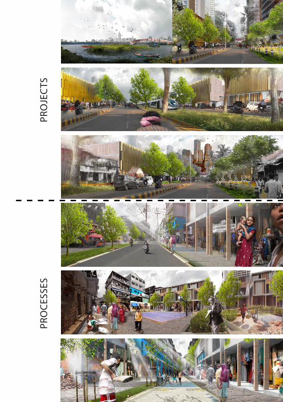
PRO
CES
SES
PRO
JEC
TS

1. TURN EXTERNAL FORCES INTO QUALITIES
plan-making process to enlarge Mithi river bed implementation
plan-makinglarge scale
developmentsimplementation
implementation
2. MAKE DHARAVI PART OF MUMBAI
2015
3. CREATE AN URBAN BACKBONE
implementation constructionplan-making process
5. INDICATE SQUARES AS NAGAR CENTERSplan-making process
implementation construction
plan-making process implementation
construction
4. ESTABLISH A LOCAL STREET NETWORKplan-making process
implementation construction
6. REDEVELOPMENT OF THE NAGARSplan-making process
implementation construction
2016
construction
plan-making process 60 ft Road
PRO
CES
SES
PRO
JEC
TS

2018
construction
construction
2017
2020
5. INDICATE SQUARES AS NAGAR CENTERSplan-making process
implementation construction
plan-making process implementation
construction
4. ESTABLISH A LOCAL STREET NETWORKplan-making process
implementation construction
plan-making process implementation
construction
6. REDEVELOPMENT OF THE NAGARSplan-making process
implementation construction
plan-making process implementation
construction
construction
2025

6.2 PROJECT MANAGEMENT OFFICEA project management office (PMO) will be opened in Dharavi. This is where all the involved parties will come together to make plans, to dicuss and negotiate.
The project management office brings together all stakeholders: government, inhabitants of Dharavi, entrepreneurs of Dharavi, developers and investors. The aim is to fill the gap between the different parties that has emerged in recent years and turn the opposite interests into common ambitions. The office is an open-house. It is the place where the meetings, as part of the participatory processes within the different phases, take place. It is accessible for all inhabitants and entrepreneurs to get updated about ongoing projects and plans. It offers a platform for commenting, protest or support. People can apply for a micro credit to upgrade their businesses or renovate their houses.
The project management office will be located along the new backbone of Dharavi, at 90ft Road.

DEVELOPERGOVERNMENT
DHARAVI INHABITANTS
PROJECT MANAGEMENT
OFFICESTREET-LED GAME
Responsibilities for the projects:• Managing the projects• Leading the projects• Bringing together all involved
parties and expertise• Updating the multi-stakeholder
institute• Managing the financing• Implementation of the project• Regulation and legalization• Relocation
Other responsibilities of the PMO:• PR of the project• Communication with inhabitants• Communication with external
parties• Update website + social media MIS
(Management Information System) about the project and make all information accessible

Felixx landscape architect & planners:Deborah Lambert, Michiel Van Driessche, Marnix Vink, Carlijn Klomp, Willemijn van
Manen, Laura Spenkelink, Steven Broekhof, Paul van Kerkoerle Studio OXL:
Wouter Oostendorp, Joop SteenkampIHS International Institute of Urban Management, Erasmus University Rotterdam:
Maartje van Eerd, Somesh sharmaNASVI:
Arbind Singh
Colofon;


![The%20 effects%20of%20second%20step%20on%20student%20behavior[1]](https://static.documents.pub/doc/80x56/58f1902c1a28abdc378b4653/the20-effects20of20second20step20on20student20behavior1.jpg)


