70
March 2009 Malitao Cu–Au PROJECT

March 2009
Malitao
Cu–Au
PROJECT


1
CONFIDENTIAL PROPERTY VISIT REPORT
MALITAO PROJECT, NORTH LUZON, PHILIPPINES, SOUTH EAST ASIA
Map of Philippines with Manila and Malitao location
Municipality of Calanasan, Kalinga-Apayao Province, Northern Luzon, Philippines
by
Bill Dynes, P. Geo., APPEGA
August 27, 2007

2
TABLE OF CONTENTS INTRODUCTION 3 DISTRICT GEOLOGY 6 GEOLOGY OF THE MALITAO PROJECT 13 PREVIOUS WORK 16 POTENTIAL RESOURCE 18 RECENT SAMPLING 18 COMMUNITY RELATIONS 22 ACCESS 23 CERTIFICATE 29
3
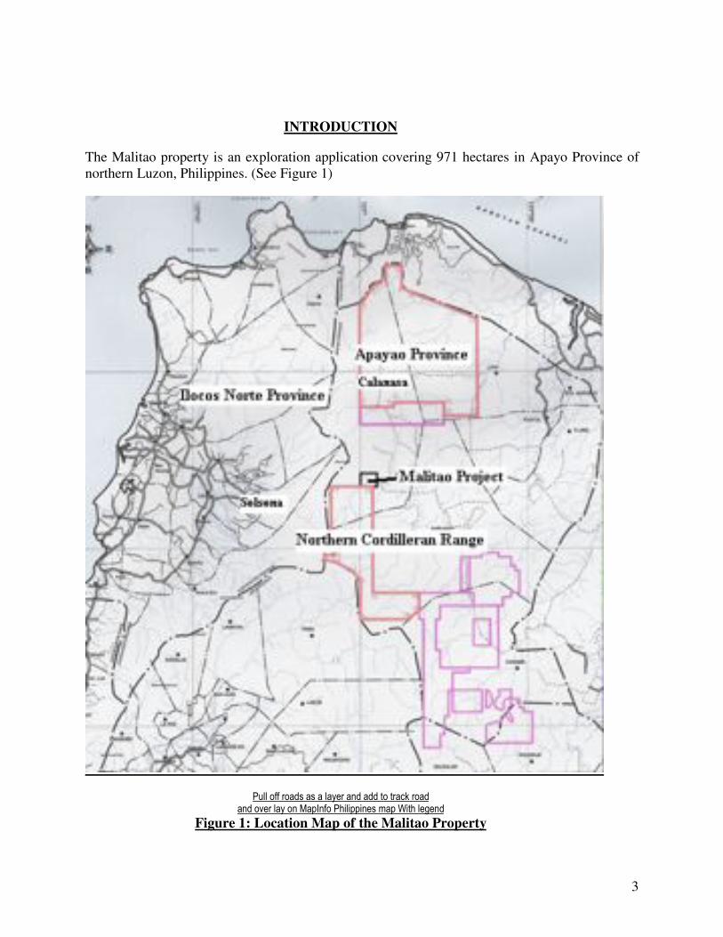
INTRODUCTION
The Malitao property is an exploration application covering 971 hectares in Apayo Province of northern Luzon, Philippines. (See Figure 1)
!"##$%&&$'%()*$(*$($#(+,'$(-)$())$.%$.'(/0$'%()$$(-)$%1,'$#(+$%-$2(34-&%$!56#6336-,*$7(3$86.5$#,9,-)$$
Figure 1: Location Map of the Malitao Property

4
A report by Philex (Philex, 1960) described the occurrence of copper mineralization within the area of the Malitao property. Grab samples of outcropping sulphide were reported to contain up to 32.74% Cu, 8.84% Zn and 2 g/t Au. Continuous chip sampling of outcropping massive sulphide by Philex in 2 separate samplings returned:
Expedition Total Sampling Width g Au/t % Cu
1st 32.32 m 0.593 3.96
2nd 93.29 m 0.566 3.5
Based on this historic report , Brian Lueck, P Geol, took the initiative of locating these occurrences in 2006 and 2007 ( B. Lueck, 2007). Lueck successfully located the occurrences and confirmed (B. Lueck, 2007) the significant nature of these copper massive suphide occurrences. This current report describes the results of a property visit to these occurrences and their further independent sampling and verification.
The Malitao occurrences are impressive. The two occurrences are almost identical in there mode of occurrence. They are both 2.5 m wide vertical lenses of massive sulphides comprised of massive chalcopyrite, boronite and chalcocite flanked to the west by semi to massive pyrite. The North and South occurrences are separated by 277 m of dense jungle vegetation.
The North and South massive sulphides occurrences host very similar mineralization and grades (____ to 47% Cu and___ % Zn) . A 1.5 m chip in the southern occurrence and 1.5 m chip in the northern returned.
This report describes the independent sampling of the Malitao occurrences and confirms results the earlier relatively spectacular results described by B. Lueck, 2007. Every effort should be made to secure and advance the exploration of the Malitao project. A $500,000 initial exploration budget is outlined which includes community relations, geophysics, geochem, geology and diamond drilling.
Numerous gossans and alteration zones were noticed to the north and north east of the property while accessing the project. Long term serious consideration should be given to expanding the exploration permit area application or to joint venturing with current application holders in these areas.
MINERAL TENURE
The mineral rights over Malitao are covered by an exploration application in the name of Al Magan Mining Exploration Corporation (AMMEC). The application covers an area of 971 hectares within a rugged and sparsely populated area. AMMEC is a 100% owned Philippine Corporation. AMMEC has signed a Memorandum of Agreement with Metex Mineral Resources Corporation (Metex) which allows for Metex to earn a 100% interest in the property, subject to a retained royalty.

5
.

6
Access
The application covers an area of 971 hectares within a rugged and sparsely populated area of northern Luzon. A good road accesses Calanasan from the coast highway emanating from Claveria. The road south from Calanasan is currently being extended to the Namaltugan Village which is within five (5) km of the Malitao project.
FIGURE with Road access and show distances.
Regional Geology
Regional geology is taken from Lueck, B., 2007.
FIGURE : TRACE GEOLOGY
Malitao property, situated in Calanasan Municipality in Apayao Province, is situated within an area of predominately basinal sediments and volcanoclastics of shallow marine origin. These rocks are intruded by a mixed group of intrusive rocks varying from quartz eye porphyry to gabbro. Late crosscutting andesite dykes strike generally north-south and dip moderately to the east (Lueck, B. 2007).
The basinal marine sediment and volcanic agglomerate are overlain unconformably by the massive limestone unit. This unit is possibly correlated with the Kennon Limestone to the south in the Baguio District. This limestone unit caps the entire area in the form of a high altitude plateau.
Below the limestone, the volcanoclastic sediments are bedded with an attitude of 050/35 NW.
GEOLOGY OF THE MALITAO PROJECT The host rock is a pyroclasitic andesite. The area between the two showings is obscured by dense vegetation. The large plateau above the occurrences is the remnant of a large limestone reef.
PREVIOUS WORK
Please refer to Lueck, B., 2007 for a review of Philex’s 1960’s program on the property.

7
CURRENT SAMPLING
SAMPLE Cu % Zn% Ag, opt Au, gm/T
004601 0.15 0.01 0.356 0.152
004602 0.19 0.24 1.385 0.102
004603 0.17 0.83 0.381 0.044
004604 0.63 8.35 1.760 0.112
004605 0.34 2.36 0.881 0.098
004606 0.32 0.65 1.897 0.170
004607 0.17 0.01 0.205 0.089
004608 0.01 0.01 0.016 0.009
004609 0.05 0.10 0.054 0.038
004610 0.02 0.01 0.112 0.019
004611 0.08 0.02 0.176 0.079
004612 0.04 0.01 0.077 0.034
004613 0.30 2.61 0.337 0.109
004614 32.59 1.21 22.494 0.984
004615 27.09 3.95 2.311 1.268
004616 36.44 1.82 28.010 0.539
004617 24.31 1.14 15.843 2.140
004618 0.33 0.20 1.481 0.315
004619 47.50 1.07 24.410 0.971
004620 33.98 2.21 20.920 1.409
004621 39.98 5.03 20.667 1.324
004622 37.10 10.38 20.449 1.425
004623 2.15 0.09 6.051 0.772
004624 25.37 0.94 2.734 0.761

8
Map of Sample locations with grades

9
COMMUNITY RELATIONS
It is of great importance to begin community relations with proper consultation so as to define the expectations and desires of the affected community for any project in the Philippines.
Initial discussions with local officials including the governor, congressman and mayor of Calanasan are extremely favorable. The community is in a very remote location and they are desperate for investment, jobs and infrastructure development.
Certification
1. I am a member in good standing of the Association of Professional Engineers and Geoscientists of Alberta, Canada.
2. I am a graduate of the University of British Columbia with a Bachelor of Science Degree
(Honors) received in 1994.
3. I have practiced my profession continually for the past 13 years.
4. I was enrolled in and completed coursework in a Master of Science program at UBC from 1994 to 1997.
5. I have been employed as an independent consulting geologist, to write this report.
6. I do not have any personal interest in the Malitao Tenement.
7. I have been on site at the Malitao Prospect during the recent exploration and personally
collected all of the samples which were assayed for this report. I have reviewed the previous data and literature written on the area. I hereby confirm that to the best of my knowledge and ability that the data contained in this report is accurate.
I hereby sign and swear the above to be true this 27th day of August, in the year of our Lord 2007. ___________________________________ William James Dynes , P.Geo. APEGGA

1
Satellite View of the Malitao Area with Indicated Foot and River Traverse from
Solsona, Ilocos Norte to Calanasan, Apayao; 65 km over the Cordilleran Divide
SUMMARY REPORT ON THE GEOLOGY OF THE
MALITAO MASSIVE SULPHIDE PROSPECT
Municipality of Calanasan, Kalinga-Apayao Province,
Northern Luzon, Philippines
by
Brian Lueck, P. Geo., APEGBC

2
TABLE OF CONTENTS
INTRODUCTION 3
DISTRICT GEOLOGY 6
GEOLOGY OF THE MALITAO PROJECT 13
PREVIOUS WORK 16
POTENTIAL RESOURCE 18
RECENT SAMPLING 18
COMMUNITY RELATIONS 22
ACCESS 23
CERTIFICATE 29

3
Figure 1: Location Map of the Malitao Property
INTRODUCTION
The mineral rights over Malitao are covered by an EP application in the name of Al
Magan Mining Exploration Corporation (AMMEC). The EP application covers an area of
971 hectares (conversion of APSA-47) within a rugged and sparsely populated area.
AMMEC is a 100% owned Philippine Corporation. AMMEC has signed a Memorandum
of Agreement with Metex Mineral Resources Corporation (Metex) which allows for
Metex to earn a 100% interest in the property, subject to a retained royalty.

4
The project was originally explored by Philex in the 1960’s but the project’s remoteness
was problematic and Philex withdrew from the prospect. Although the area has been
visited several times by geologists since the work of Philex, no significant exploration
of any kind has been undertaken at Malitao in over 35 years.

5
Two separate visits to the property (October 18th
to 22nd
, 2006 and February 10th
to 15th
,
2007) have been undertaken by the author, both to examine the larger regional geology
and access of the area, and to examine and sample the exposed mineralization.
Malitao is a multi element but predominantly copper-gold massive sulfide deposit
associated with a large granitic batholith and prominent dyke swarm that intersects
heterolithic shallow marine volcanoclastics and massive limestone near and within the
Malitao property. The mineralization outcrops at or near the unconformable contact
between the units and occupies a section of the stratigraphy known to host coal seams.
The deposit is interpreted as a ‘Manto Replacement Deposit’. The most common copper
minerals are chalcocite, covellite, bornite, and chalcopyrite which occur in massive and
silicified pyritic volcanoclastic sediments.
Grab samples of outcropping sulphide beds taken by Philex contain up to 32.74% Cu,
8.84% Zn and 2 g/t Au. Continuous chip sampling of outcropping massive sulphide by
Philex showed 2 separate samplings with the following results:
Expedition Total Sampling Width g Au/t % Cu
1st 32.32 m 0.593 3.96
2nd 93.29 m 0.566 3.5
The thickness of intersected massive sulfides indicated in drilling by Philex in 1969 is
between 6 meters and 20 meters.
A copper in soil anomaly measuring 800 meters by 400 meters in extent had been
delineated (Philex) over marine clastic sediments below the contact with the capping
limestone. Drilling has tested only a very small part of this large anomaly. Only a small
part of the project area has been explored and the soil anomaly remains open.
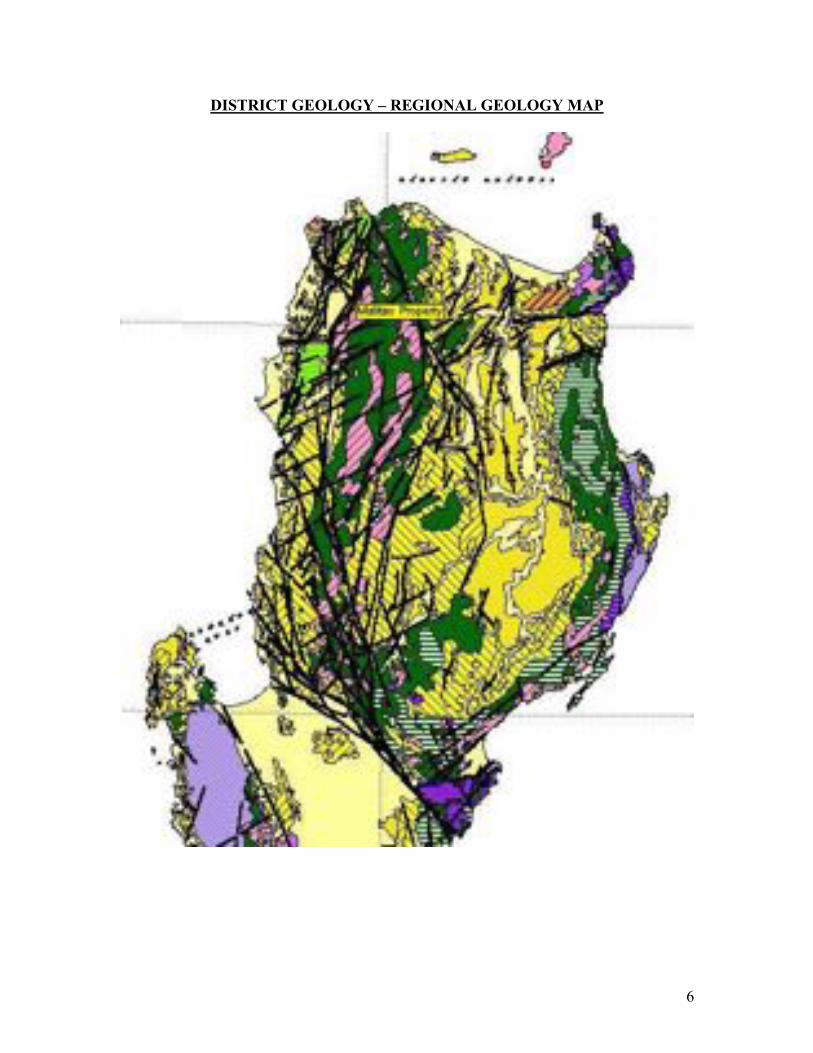
6
DISTRICT GEOLOGY – REGIONAL GEOLOGY MAP
7
MAP LEGEND

8
Photo 1: This view shows the massive limestone unit, possibly correlated with the
Kennon Limestone, capping the backbone of the Cordilleran Divide between Ilocos
Norte Province and Apayao Province. Coralline fossils of assumed Miocene age are
found within the formation.
The Malitao property, situated in Calanasan Municipality in Apayao Province, is situated
within an area of predominately basinal sediments and volcanoclastics of shallow marine
origin. In traversing from the Solsona area in Ilocos Norte up to the divide with Apayao,
the rocks are composed of a mixed group of intrusive rocks varying from quartz eye
porphyry to gabbro, which in places borders on pyroxenite. Late crosscutting andesite
dykes strike generally north-south and dip moderately to the east.
These intrusive rocks are in contact to the east with basinal marine sediment and volcanic
agglomerate, which is overlain unconformably by the massive limestone unit pictured
above. This unit is possibly correlated with the Kennon Limestone to the south in the
Baguio District. This limestone unit is a continuous cap over the entire area and extends
to the Malitao Property.
The nature of the contact between the intrusive rocks and the sediments to the east is
unknown, but no skarn or replacement sulphide mineralization is seen in this area of the
section. It appears that the intrusive rocks found in Ilocos Norte pre date the sediments,
and this is currently the author’s interpretation.

9
Photo 2: This photo shows the inside of an extensive limestone cave area situated on
the Malitao property. This cave appears to occur as a result of underground stream
action dissolving the limestone near its’ basal contact with the underlying sediments
and volcanoclastics. The Malitao deposit occurs 2 km east of these caves at or just
below the same elevation and this horizon appears to be particularly favorable for
fluid flow.
There is good exposure of the contact between the flat lying limestone cap and the
moderately dipping sandstone and volcanoclastic which underlies it. At or near this
unconformable contact the author found discontinuous coal seams within the sandstone
indicating a shallow marine coastal environment during the deposition of the sediments.
Further down in the section, the sediments are well bedded, ripple marked and dip
uniformly with an attitude of 050/35 NW.

10
Photo 3: This photo shows the underside of a slab of sandstone showing excellent
ripple mark features indicating a shallow marine environment for deposition of this
unit.
11
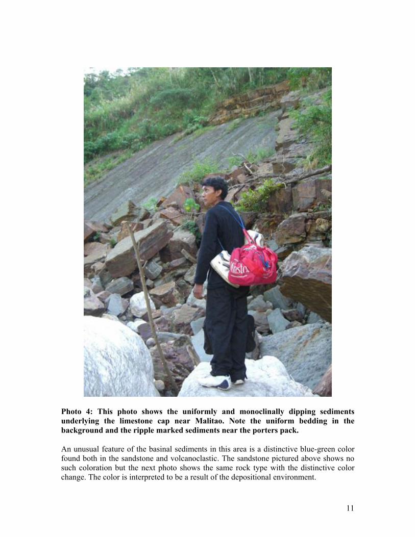
Photo 4: This photo shows the uniformly and monoclinally dipping sediments
underlying the limestone cap near Malitao. Note the uniform bedding in the
background and the ripple marked sediments near the porters pack.
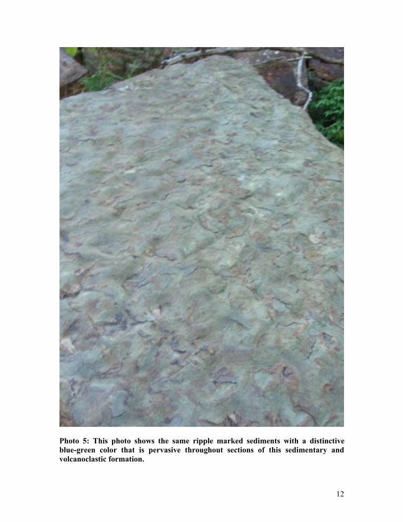
An unusual feature of the basinal sediments in this area is a distinctive blue-green color
found both in the sandstone and volcanoclastic. The sandstone pictured above shows no
such coloration but the next photo shows the same rock type with the distinctive color
change. The color is interpreted to be a result of the depositional environment.
12
!
Photo 5: This photo shows the same ripple marked sediments with a distinctive
blue-green color that is pervasive throughout sections of this sedimentary and
volcanoclastic formation.

13
Photo 6: This photo shows a typical boulder of volcanoclastic agglomerate which is a
major part of the sedimentary formation near and on the Malitao Property.
The most obvious feature of the rock units and formations between Ilocos Norte Province
and the Malitao Property is that they are completely devoid of any kind of sulphide
mineralization. Not a single outcrop or a single piece of sulphide bearing float can be
seen in any of the drainages flowing from the divide towards Apayao. There is also a
complete lack of any form of intrusive rock in the area, including dykes or sills. As with
the lack of sulphide mineralization, not a single outcrop or piece of intrusive or andesite
rock is present or can be found in these same drainages.
GEOLOGY OF THE MALITAO PROJECT
The above described lack of mineralization and magmatism changes abruptly upon
arrival to the Malitao Property. A prominent and extensive andesite and micro-diorite
dyke swarm cuts strongly and steeply through the thick sedimentary package. Intense
areas of sulphide alteration and replacement measuring tens of meters wide occur at the
contacts of these dykes within the sediments. These sulphide replacement zones appear to
dip steeply and follow the contacts of the dykes. Flat columnar jointing and chilled
margins within the dykes show that they are emplaced as magma into the sediments and
are oriented almost vertically.

14
It is obvious to the author that the mineralization at Malitao is related to this intrusive
activity, although the Malitao Massive Sulphide Deposit is different in character to the
sulphide replacement zones seem in the sediments adjacent to the dykes.
Photo 6: This photo shows outcropping volcanoclastic sediment which underlies the
Malitao Deposit and the massive limestone unit.

15
Photo 7: This photo shows a massive sulphide breccia boulder in the river just
below the Malitao deposit. It is texturally similar to the volcanoclastic sediment and
it appears that the sulphides have replaced the matrix within the sediment.
Photo 8: This photo is taken from the same location as photo 7 and shows a narrow
andesite dyke cutting the sedimentary formation underlying the Malitao Property.
Pyritic altered sediments are visible in the upper right of the photo.

16
Photo 9: This photo is taken downstream from the Malitao Deposit but still within
the Malitao Property. Note the wide sulphide alteration zone adjacent to the dyke in
the right of the photo.
PREVIOUS WORK
The project was originally explored by Philex in the 1960’s but the project’s remoteness
was problematic and Philex withdrew from the prospect. Although the area has been
visited several times by geologists since the work of Philex, no significant exploration
of any kind has been undertaken at Malitao in over 35 years. Grab samples of
outcropping sulphide beds contain up to 32.74% Cu, 8.84% Zn and 2 g/t Au.
Continuous chip sampling of outcropping massive sulphide by Philex showed 2 separate
samplings with the following results:
Expedition Total Sampling Width g Au/t % Cu
1st 32.32 m 0.593 3.96
2nd 93.29 m 0.566 3.5
The thickness of intersected massive sulfides indicated in drilling by Philex in 1969 is
between 6 meters and 20 meters.

17
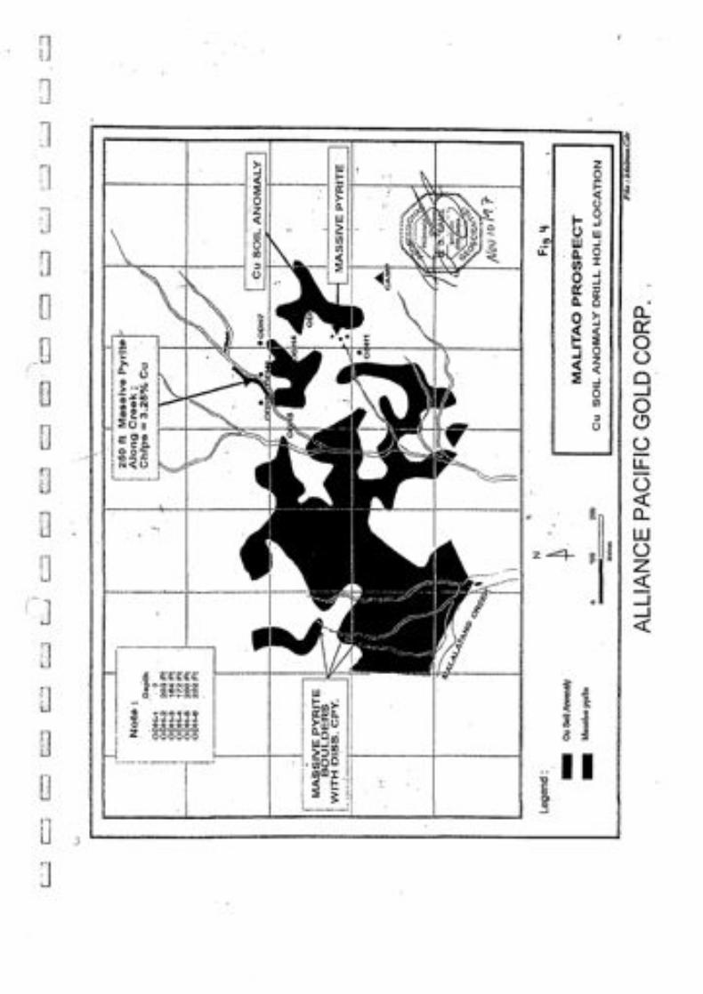
Figure 2: Copper in soil geochemical anomaly map with locations of massive
sulphide outcrops and boulders and old Philex drill holes.
In DDH-1, the first of 7 very poor recovery small-diameter holes drilled by Philex
Mining Corporation in 1969 (refer to Figure 2), a massive sulfide intersection, was
reportedly 6 meters thick underlain by slightly pyritic conglomerate and sandstone. In
DDH-3, a massive sulfide intersection of pyrite, chalcopyrite, bornite and covellite was
23.5 meters thick underlain by 9.1 meters of altered pyritic rock with chalcopyrite
disseminations, followed by 4.8 meters of pyritic volcanic, followed by 2.4 meters of red
shale at the drill hole bottom.
Historical data from the Philex exploration is sparse and the extremely poor recovery was
so disappointing that Philex neglected to assay the drill core intervals, or the data was
lost. Only drill log descriptive data of a cursory nature is available. Soil sampling by
Philex was over a limited area but showed a strong copper in soil anomaly down slope
from the outcropping massive sulphides. It is this author’s opinion, from reviewing the

18
old data and talking directly to the people involved in the exploration 37 years ago, that
the program was logistically difficult due to the absence of man portable drilling
equipment, the remoteness of the location, and former poor relations with the locals.
POTENTIAL RESOURCE
No potential resource has been estimated for the Malitao massive sulfide deposit. In view
of the extent of the soil copper anomaly, large prominent high grade outcrops and the
inferred ‘Manto Type’ origin of the deposit, a large tonnage (>10 Mt) massive sulphide
copper-gold deposit target is found to exist at Malitao.
RECENT SAMPLING
The author traveled to Malitao to view, photograph and sample the outcropping massive
sulphide material. The area was accessed by a 2 hour motorized Banka boat ride from
Calanasan and then a 4 hour hike to the Sitio of Malitao. A large granitic intrusion occurs
to the east of the Malitao mineralization and may be the source of the fluids which caused
the mineralization at Malitao.
From Malitao, the mineralization is accessed by foot trail and it takes approximately 1
hour to hike up to the outcrops. Since the exploration by Philex over 35 years ago, there
is a lot of growth in the area and some of the outcrop areas were completely overgrown.
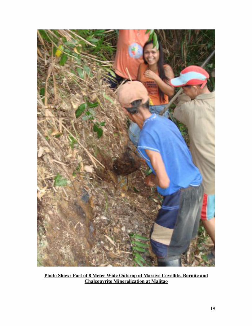
One large outcrop located near the previous DDH-1, at least 8 meters in exposure, was
chip sampled and consisted of almost massive covellite, with lesser quantities of bornite,
sphalerite and chalcopyrite. Results range between 14.8% to 34% copper, 1.4% to
26.4% zinc, 1.18 to 1.57 g/T Au and 303 to 534 g/T Ag.
Below the outcrop area, the hillside is covered with massive sulphide rubble, and the soil
is composed predominately of sulphide fragments. The overall impression is that the
deposit is extensive, as the other areas of overgrown outcrop previously sampled by
Philex are several hundred meters north from this site.
19
Photo Shows Part of 8 Meter Wide Outcrop of Massive Covellite, Bornite and
Chalcopyrite Mineralization at Malitao

20
Photo Shows the Author Examining the Talus Apron of Massive Sulphide Material
below the Sampled Outcrop
Photo is Looking North from the Sampled Outcrop toward the Area Sampled by
Philex Previously which Occurs in the Gulley behind the Hill in the Foreground.

21
Photo Shows Massive Sulphide Boulder from Outcrop consisting of Massive
Covellite with lesser Bornite and Chalcopyrite

22
COMMUNITY RELATIONS
Photo 11: This photo shows a picture of the author with the local residents of
Malitao Sitio. Several of the individuals pictured were hired for the expedition and
it is this author’s opinion that the residents are friendly and openly endorse
exploration and development for their community.
It is of great importance to begin community relations with proper consultation so as to
define the expectations and desires of the affected community for any project in the
Philippines.
Initial discussions with local officials including the governor, congressman and mayor of
Calanasan are extremely favorable. The community is in a very remote location and they
are desperate for investment, jobs and infrastructure development.

23
Photo 12: This photo shows a group of local people including the Barangay captain,
situated far left, enjoying a friendly singing and drinking session.
ACCESS
Access to the project area has always been problematic and that is one of the main
reasons why this highly prospective property has not yet been extensively explored. The
author traveled from Solsona in Ilocos Norte on foot with porters and guides. It was a two
day, sunup to sundown hike to the project area. An old road or cat trail, pushed in perhaps
during the 1960’s to 1970’s is followed by much of the current foot trail in. There are
numerous landslides which have destroyed parts of the trail.
It is this author’s opinion that it would be a very difficult proposition to upgrade this road
to 4 wheel drive passable, and an impossibility to maintain it through the rainy season
without massive expenditures for slope stabilization.

24
Photo 13: This photo shows part of the old road at the pass between Ilocos Norte
and Apayao. Although 95% of the trail needs only slight work to rehabilitate, the
other 5% which is eroded by landslides makes the rehabilitation of the road from
Ilocos Norte a prohibitive cost to the company.
The other method of access to the property is currently by boat from Calanasan in
Apayao. Motorized river boat or jet boat can provide adequate access during most
seasons to or near to the Malitao Sitio from Calanasan. An all season road links
Calanasan to Claveria, Cagayan on the north coast. Vehicle access to bring in drill rigs is
therefore adequate up to Calanasan.
From Calanasan, the government is currently constructing a gravel road to Malitao. The
road is not yet completed but from what the author saw on the way out, the road appears
to be relatively easy to upgrade to 4 wheel drive passable to within a few kilometers of
Malitao, and perhaps all the way to the project area if current road work progresses. The
topography is not extreme and this is definitely the preferred access route. For initial
exploration, motorboat access is acceptable. For advanced exploration and drilling, it is
recommended that a thorough cost study be looked at to upgrade the road from
Calanasan, including discussions with the local government to share expenses.

25
The above photo shows the route taken to Malitao from Calanasan. Although the area
was traversed by motorized Banka, the road under construction (red line) was visible
from the river and is currently being bulldozed. The road is pushed to the start of the foot
trail into Malitao.
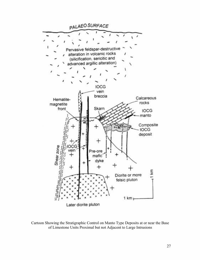
Prominent northeast striking structures at Malitao follow through to the contact of the
granite batholith which occurs approximately 2 km to the east of Malitao. A large copper
bearing sulphide zone occurs at the river, northeast of Malitao, adjacent to the contact of
the limestone with the underlying prominently volcanoclastic sediments.
This stratigraphic control on sulphide mineralization is the same as that seen at the
Malitao Deposit, and it appears that a favorable manto replacement horizon occurs at the
unconformable contact between the underlying volcanoclastics and shallow marine
sediments, and the overlying massive limestone and marble. This horizon is known to
contain coal seams, and current theories on the formation of pyrobitumen associated

26
copper manto deposits1, may make this an important element in the stratigraphic control
on mineralization.
Photo 14: This photo shows local entrepreneurs hauling the author and party up the
river to Calanasan by manpower alone. Motorized boats can be rented from the
Calanasan side to transport clients into the Malitao area. Note the rolling nature of
the hills and moderate topography this side of Malitao.
1 Wilson and Zintilli, 2006. Association of pyrobitumen with copper mineralization at Uchumi and Talcuna
districts, central Chile. International Journal of Coal Geology 65 (2006) 158-169.
27
Cartoon Showing the Stratigraphic Control on Manto Type Deposits at or near the Base
of Limestone Units Proximal but not Adjacent to Large Intrusions
28
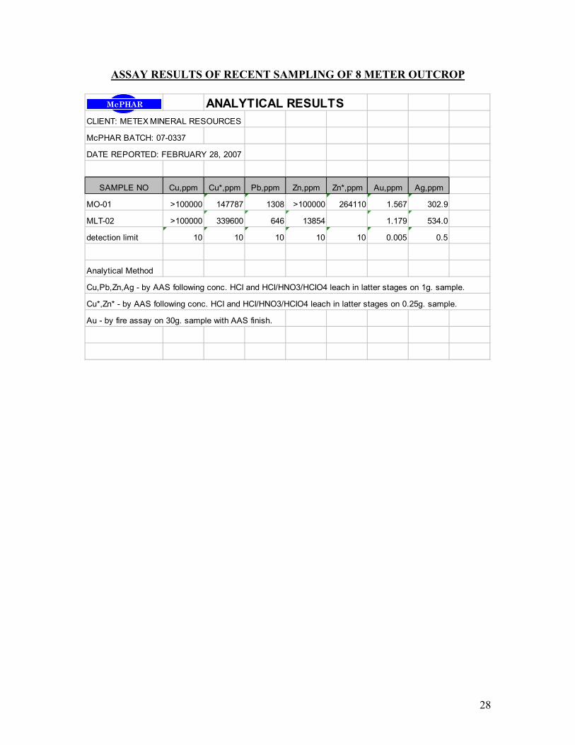
ASSAY RESULTS OF RECENT SAMPLING OF 8 METER OUTCROP
ANALYTICAL RESULTS
CLIENT: METEX MINERAL RESOURCES
McPHAR BATCH: 07-0337
DATE REPORTED: FEBRUARY 28, 2007
SAMPLE NO Cu,ppm Cu*,ppm Pb,ppm Zn,ppm Zn*,ppm Au,ppm Ag,ppm
MO-01 >100000 147787 1308 >100000 264110 1.567 302.9
MLT-02 >100000 339600 646 13854 1.179 534.0
detection limit 10 10 10 10 10 0.005 0.5
Analytical Method
Cu,Pb,Zn,Ag - by AAS following conc. HCI and HCI/HNO3/HCIO4 leach in latter stages on 1g. sample.
Cu*,Zn* - by AAS following conc. HCI and HCI/HNO3/HCIO4 leach in latter stages on 0.25g. sample.
Au - by fire assay on 30g. sample with AAS finish.
!"#$%&

29
Certification
1. I, Brian A. Lueck am a member in good standing of the Association of Professional
Engineers and Geoscientists of British Columbia, Canada.
2. I am a graduate of the University of British Columbia with a Bachelor of Science
Degree (Honors) received in 1985.
3. I have practiced my profession continually for the past 20 years.
4. I was enrolled in and completed coursework in a Master of Science program at
UBC from 1991 to 1994.
5. I have been employed by Metex Mineral Resources Corporation as an independent
consulting geologist, to write this report.
6. I do not have any personal interest in the Malitao Tenement.
7. I have been on site at the Malitao Prospect during the recent exploration and
personally collected all of the samples which were assayed for this report. I have
reviewed the previous data and literature written on the area. I hereby confirm that
to the best of my knowledge and ability the data contained in this report is accurate.
I hereby sign and swear the above to be true this 26th
day of March, 2007:
___________________________________
Brian A. Lueck, P.Geo. APEGBC
BRIAN A. LUECK, P. GEO.


Southern Outcrop
Central Outcrop

North Outcrop


