EXECUTIVE SUMMARY This Hook Creek Preliminary HDD Feasibility Assessment Report (this report) was prepared by WorleyParsons Canada Services Ltd. (WorleyParsons) for Northern Gateway Pipelines Inc. (Northern Gateway) in support of a regulatory application for approval to construct and operate the Enbridge Northern Gateway Project (the Project).
This report discusses the feasibility of using a horizontal directional drilling (HDD) construction technique to cross Hook Creek. Based on a review of the available geological and / or geotechnical information, site visits, site photos and ground profiles, an HDD technique appears to be a feasible crossing method. This crossing will require a detailed survey and geotechnical investigations during detailed engineering to further assess the feasibility of an HDD and to prepare the detailed designs. The contingency plan is to cross Hook Creek using an isolated crossing method during July to August.
TABLE OF CONTENTS EXECUTIVE SUMMARY.......................................................................................................................... III
3. HOOK CREEK (SITE NO. 390) PRELIMINARY DESIGN........................................................6 3.1 Site Location and Access Details..............................................................................................6 3.2 Route Revision R Centreline Alignment....................................................................................6 3.3 Design Profile and Parameters .................................................................................................7 3.4 Design Considerations for the 914 mm (NPS 36) and 508 mm (NPS 20) Pipe........................7 3.5 Drilling Schedule .......................................................................................................................9 3.6 Contingency Plans ....................................................................................................................9
1. INTRODUCTION This Hook Creek Preliminary HDD Feasibility Assessment Report (this report) was prepared by WorleyParsons Canada Services Ltd. (WorleyParsons) for Northern Gateway Pipelines Inc. (Northern Gateway) under the Enbridge Northern Gateway Project (the Project).
The pipelines will cross approximately 773 identified watercourses having defined bed and banks. An initial screening process identified 83 of these crossings requiring more detailed review to determine the preferred crossing method. Currently, the horizontal directional drilling (HDD) method is the preferred crossing method for Hook Creek.
This report has been prepared to comply with the National Energy Board (NEB) filing requirements regarding proposed HDD crossings, specifically to provide a preliminary feasibility report detailing the assessment that was done to determine that HDD could be successfully completed and a description of the contingency plan to be used if the HDD is not successful.
1.1 Purpose
This report discusses the feasibility of using a HDD trenchless construction technique to cross Hook Creek. Based on a review of existing geological and / or geotechnical information where available, site visits, site photos and ground profiles, an HDD technique appears to be a feasible crossing method. This crossing will require a detailed survey and geotechnical investigations to further assess the feasibility of an HDD and to prepare the detailed designs.
The location of the crossing with respect to the pipeline alignment is shown in Table 1.
Northern Gateway Pipelines Inc. (Northern Gateway), a subsidiary of Enbridge Pipelines Inc., initiated the regulatory phase of the Enbridge Northern Gateway Project (the Project) to obtain regulatory approvals to construct and operate the Project. The Project is being developed to provide pipelines and associated facilities for the transportation of approximately 83,400 m3/d (525,000 bbl/d) of oil from Bruderheim, Alberta to Kitimat, British Columbia and the transportation of approximately 30,700 m3/d (193,000 bbl/d) of condensate from Kitimat to Bruderheim.
The Project includes the following major components:
an oil pipeline, 914 mm OD (NPS 36), approximately 1172 km long extending from the outlet of the Bruderheim station to the Kitimat Terminal
a condensate pipeline, 508 mm OD (NPS 20), approximately 1172 km long, located in the same right-of-way as the oil pipeline, extending from the Kitimat Terminal to the Bruderheim Station
the Bruderheim Station, consisting of the oil initiating pump station and the condensate receiving facilities
eight intermediate pump stations located at intervals along the pipelines
two tunnels, approximately 6.5 km and 6.6 km long, to route the oil and condensate pipelines between the Clore River and Hoult Creek valleys
the Kitimat Terminal which will comprise the following:
o a tank terminal including oil tanks, condensate tanks and associated infrastructure
o a marine terminal including two tanker berths and one utility berth
o an initiating condensate pump station
o oil receiving facilities
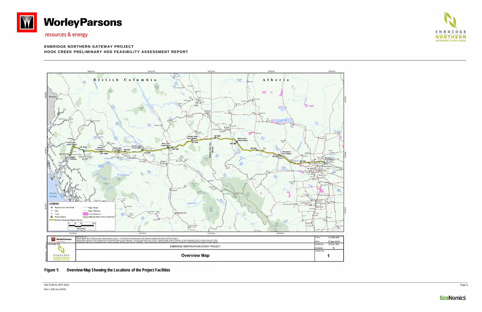
For an overview map showing the locations of these project facilities, see Figure 1.
Horizontal Directional Drilling (HDD) is a trenchless crossing technique widely used for the installation of pipelines below watercourses, as well as below other infrastructure such as railways, highways and foreign pipelines. Under appropriate conditions, the HDD technique is practical for installations up to about 2000 m long for the pipeline diameter ranges under consideration on the Project.
The Hook Creek crossing, at a horizontal length of 672 metres and with pipe diameters of 914 mm OD (NPS 36) and 508 mm OD (NPS 20), falls within current practical length limits. The feasibility of HDD rests primarily upon the geotechnical conditions encountered at a particular site. Other critical factors are suitable topography and availability of temporary workspace for laydown of the makeup section of pipeline.
The HDD design for a 914 mm OD (NPS 36) steel heavy wall pipe requires a preliminary design bend radius of at least 1,100 m. The entry and exit angles range from 12° to 16° and minimum entry and exit tangent lengths are 50 m. This basic limiting geometry, site topography, the no-drill zone (NDZ) established by the geotechnical engineer and other drilling and construction requirements will determine, in most cases, the overall length of the HDD. For this Project, the minimum practical length will be about 500 m (depending on topography and the results of the final geotechnical investigations).
The geotechnical engineer’s report will typically specify the extent and shape of a NDZ as a guide for the HDD design engineer. The NDZ includes an assessment of the drill profile required both to prevent release of drilling fluids to the ground surface during drilling and to avoid potential zones of slope instability. An HDD profile will be a minimum of 10 m below a watercourse and could be substantially deeper. The minimum drill depth below surface to prevent release of drilling fluid to the surface is dependent on hydrostatic mud pressures and the permeability and strength of overlying soil and rock. Generally, most HDD crossings are drilled with the entry point on the low elevation side to minimize the fluid pressure in the pilot hole while maximizing fluid return to the drill rig. Drilling fluid, typically made up of bentonite and water, is cleaned of drill cuttings at the drill rig and then reused in the drilling process.
Since full circulation of drilling fluids is not possible in permeable soils such as coarse sand and gravel, steel pipe ‘casing’ driven through the surficial sand and gravel materials is used to isolate and seal the drill bore profile from these porous materials. Typically, casing is sealed into a lower competent soil or rock.
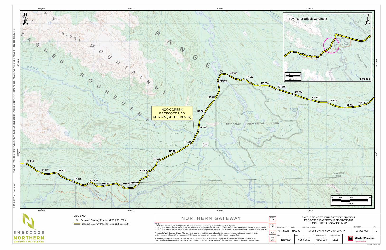
The Hook Creek crossing is located at KP 602.5, (see Attachment 1 in Appendix B), on the eastern flanks of the Rocky Mountains northwest of Monkman Provincial Park. The crossing is located approximately 250 m upstream of the confluence of Hook Creek with Imperial Creek approximately 1.6 km west of where Imperial Creek joins the Murray River. Hook Creek flows southeast in an irregular meandering channel that is typically narrow, steep-sided and incised approximately 15 to 30 m into the bottom of a larger U-shaped glacial valley. In the vicinity of the proposed crossing, the Hook Creek floodplain ranges from about 75 to 150 m wide. The approach slopes are gentle to the west, steep to the east, and about 15 to 20 m high. Approach slopes along the proposed HDD path are typically steeper, although these steep slopes have minimal influence on this crossing method. The east and west valley slopes become much higher and steeper upstream of the crossing where the stream is confined in an incised canyon.
The Hook Creek area has been previously logged and access from upland areas southwest of the crossing to the nearby Monkman Provincial Park is via the Murray Forest Service Road. Old forestry spur roads are located near the crossing; however, the bridge across Imperial Creek to access areas east of the crossing has been removed. There are no presently useable roads that access valley bottom areas near the crossing.
3.2 Route Revision R Centreline Alignment
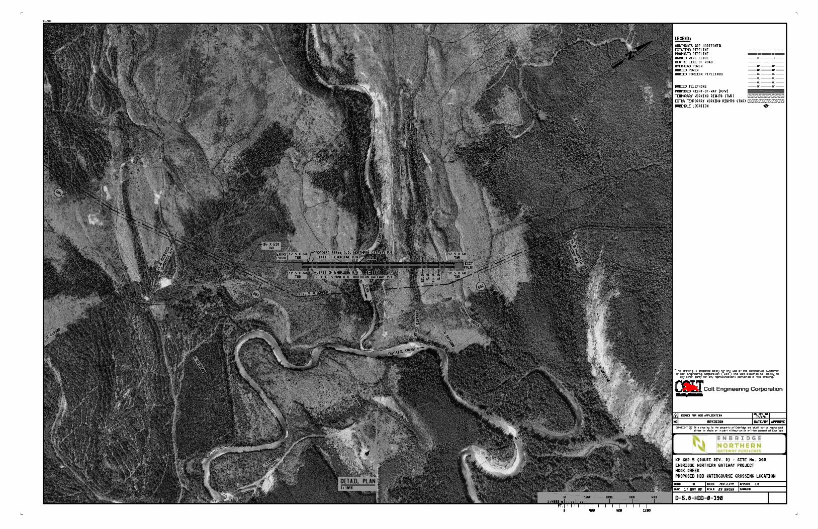
The proposed HDD alignment is shown in Attachment 2 (see Appendix B) and is not coincident with the Route Rev. R centreline. The HDD has a horizontal crossing length of 672 m. A route revision is recommended to align with the HDD alignment.
In the vicinity of the proposed crossing, the Hook Creek floodplain ranges from about 75 to 150 m wide.
One preliminary HDD design drawing has been prepared (see Attachment 3 in Appendix B) for both the 914 mm OD (NPS 36) and the 508 mm OD (NPS 20) watercourse crossings. The preliminary radius of curvature used on the HDD design drawing for both pipes is 1,100 m, the industry standard for 914 mm OD (NPS 36) pipe. The design of the 508 mm OD (NPS 20) pipe crossing will be reviewed during detailed engineering, when site-specific geotechnical and survey information is available. A smaller design radius, in the range of about 600 m is feasible for the 508 mm OD (NPS 20) pipe which can potentially result in a shorter HDD drill length, depending on the detailed subsurface conditions and the joint design considerations of the two pipelines. The entry and exit angles for the 508 mm OD (NPS 20) HDD can be increased compared to the 914 mm OD (NPS 36) pipe, providing additional flexibility in the final design of the drill profile.
The two crossings are proposed to be within a common 25 m wide right-of-way (ROW). Within the ROW, the current plan proposes that the HDDs for the two parallel pipelines will have a horizontal separation distance of 15 m. Additional workspace is needed on the entry and exit sides of the drill. The drawings show a 50 m by 60 m combined temporary working rights (TWR) space and ROW area at both the entry and exit sites. This space is required for the rig setup and for the required work at the entry and exit sites. Additional workspace may be required for various construction and topographic considerations.
This HDD assessment is preliminary, pending more detailed site survey and geotechnical information.
3.4 Design Considerations for the 914 mm (NPS 36) and 508 mm (NPS 20) Pipe
The crossing location has been visited on a number of occasions for route selection purposes. Geotechnical information for the Hook Creek crossing is contained in the report Preliminary Geotechnical HDD Feasibility Assessment Hook Creek (Crossing #390). This report contains results of a review of the existing geological information as well as observations made during the site visits. The report also provides preliminary NDZ recommendations.
Based on the centreline Route Rev. R alignment and the geotechnical recommendations, including the proposed no-drill zone, a preliminary crossing design has been carried out. Three drawings have been prepared for the crossing:
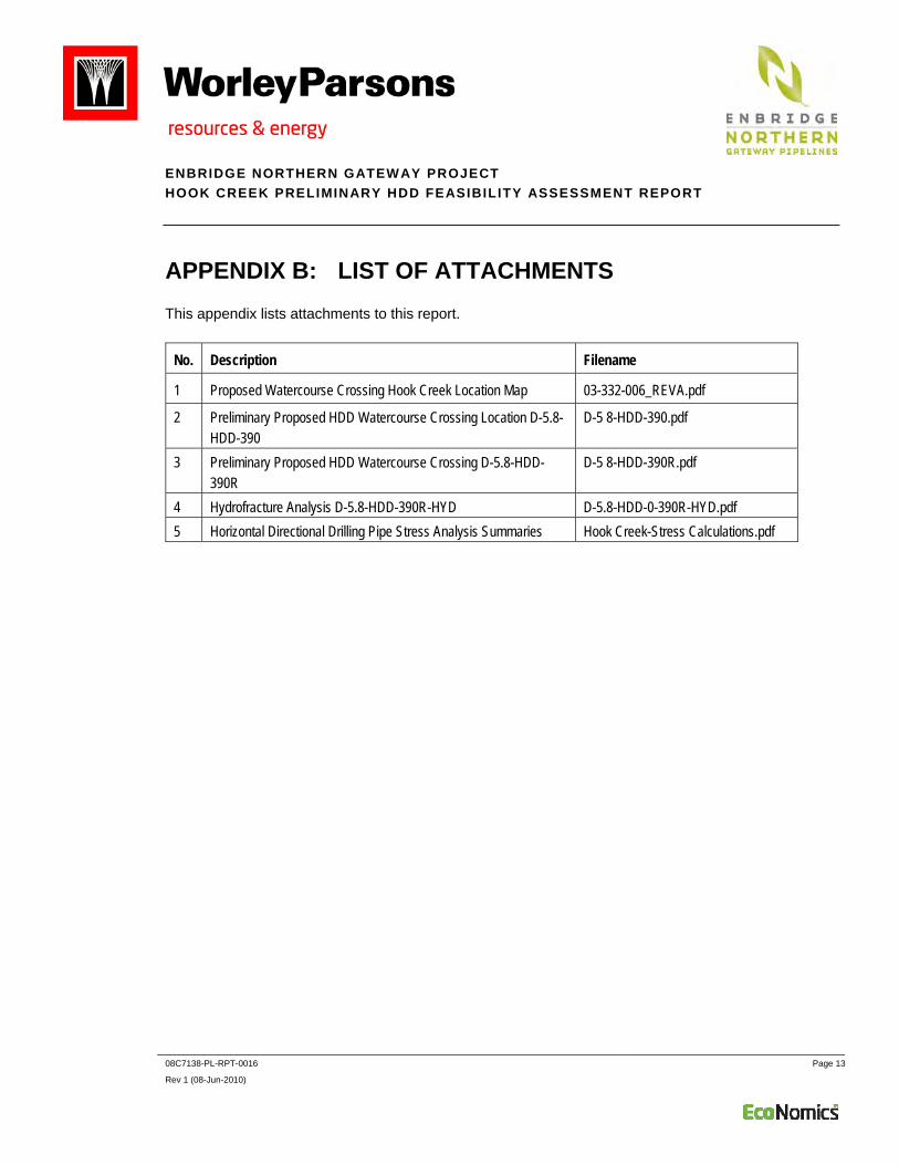
Preliminary Proposed HDD Crossing Location D-5.8-HDD-390 (see Attachment 2 in Appendix B)
Preliminary Proposed HDD Crossing D-5.8-HDD-390R (see Attachment 3 in Appendix B)
Hydrofracture Analysis D-5.8-HDD-390R-HYD (see Attachment 4 in Appendix B)
Due to the proposed crossing location and alignment a change in the Route R alignment will be required, at both entry and exit sides. The Rev. R alignment across the river would not be the most suitable for an HDD. The HDD will cross both Hook Creek and an unnamed creek about 300 m to the north.
As shown on the proposed HDD crossing drawing, the preliminary proposed drill path will be about 678 m long. The total heavy wall pipe length will be 711 m, including an additional 33 m to allow for the tie-ins. The pipe will cross Hook Creek at a depth of about 41 m below the higher ground surface elevation on the northwest side of the crossing. The deepest point below the riverbed will be 21.2 m. The pipe will enter and exit the ground at an angle of 12°. The entry and exit locations are setback from the centre of Hook Creek by approximately 245 m and 427 m respectively. The northwest side has been selected as the entry side as it is more or less 2 m lower in elevation than the southwest side. The makeup section will be strung out on the entry side, or southwest side. This may necessitate moving the rig to the exit side for the pull through. Additional TWR will be required to lay out the makeup section in a relatively straight line. Because of the route realignment proposed in the pipeline ROW, it will not be possible to place the makeup area entirely along the existing Route Rev. R alignment. Existing road ROWs and clear-cuts will be used where possible.
The hydrofracture calculation curve is shown on the drawing in Attachment 4 (see Appendix B). This drawing demonstrates that the drill profile provides sufficient depth to minimize the risk of fluid release to the surface based on the preliminary parameters chosen for the design. It is typical for this drawing to be used by the drilling contractor in conjunction with a required annular pressure monitoring tool to control the potential for drilling fluid release and loss of drill fluid circulation.
Casing may be planned for the entry side. The requirement for casing on the exit side will be reviewed during detailed design when subsurface information is available. If casing is required on both sides of the crossing to penetrate sand and gravel, then a drill intersect will most likely be required. Casing size is anticipated to be a minimum of 1372 mm (NPS 54) in diameter with a minimum of 19 mm wall thickness for the NPS 36 pipeline. If telescoping of the casing is required, then the initial casing size may be 1524 mm (NPS 60) or greater with a wall thickness of about 25.4 mm. Casing will be suitably sized for the NPS 20 pipeline.
Construction of the 914 mm OD (NPS 36) crossing may require a schedule of four months of drilling excluding time to install casing. The 508 mm OD (NPS 20) pipe may require a drilling schedule of up to three months. A total time of, approximately seven months will be required to complete back-to-back drills. Consideration may be given to drilling the two crossings simultaneously, within the timeframe required for the larger drill. HDD construction activities will include clearing, grading, mobilization, casing installation, pilot hole drilling, reaming, product pipe pull, demobilization and site restoration.
The calculations in Attachment 5 (see Appendix B) show that the pull loads are estimated to be 444,000 lb. (excluding buoyancy control). The pull force for the 914 mm OD (NPS 36) pipe with buoyancy water reduces to about 171,000 lb. Assuming the same drill length the pull force calculated for the 508 mm OD (NPS 20) pipe is 193,000 lb. without buoyancy control and 100,000 lb. with buoyancy control. Buoyancy control should be considered for the two drills to minimize the pull loads and drill rig size requirements.
The location of the proposed HDD crossing should allow for drilling to occur in either winter or summer. Year round access is preferable and would eliminate the need to drill the 508 mm OD (NPS 20) and 914 mm OD (NPS 36) simultaneously, although this could be an option for the HDD contractor. If drilling is only possible in a single season then the crossings would need to be drilled simultaneously. Detailed design will include a review of the temporary working rights at entry to ensure that sufficient room is available for two drill rigs to be working on site simultaneously. The elevation difference between entry and exit dictates the two HDDs do not need to be drilled from the same side. However, it is anticipated that the 508 mm OD (NPS 20) drill path can be designed to allow the entry points to be staggered. Additional workspace will be required for a simultaneous drill.
3.6 Contingency Plans
If, during detailed engineering, the HDD crossing method is determined to be not feasible, or if the attempted HDD installation fails, the contingency method of pipeline installation at Hook Creek is an isolated crossing method during July to August.
4. CONCLUSIONS Based on the available data and information, the preliminary assessment indicates that an HDD crossing of Hook Creek is feasible at this location for both the 508 mm OD (NPS 20) and 914 mm OD (NPS 36) pipelines. A separation of pipeline crossings of 15 metres is considered acceptable; however, this will need to be reviewed once more detailed geotechnical information is obtained. Additional survey and geotechnical investigation and laboratory testing will be required to further assess the feasibility of an HDD and for preparation of the detailed designs. Final design will consider drill profiles for both the 508 mm OD (NPS 20) and 914 mm OD (NPS 36) pipeline crossings.
The contingency plan is to cross Hook Creek using an isolated crossing method during July to August.
APPENDIX A: ABBREVIATIONS This appendix lists abbreviations used in this report.
Term Spelled Out
° degree(s) bbl/d barrels per day HDD horizontal directional drilling km kilometre(s) KP kilometre post m metre(s) m3/d cubic metres per day mm millimetre(s) NDZ no-drill zone Northern Gateway Northern Gateway Pipelines Inc. NPS nominal pipe size OD outside diameter ROW right-of-way the Project the Enbridge Northern Gateway Project this report this Hook Creek Preliminary HDD Feasibility Assessment Report TWR temporary work right WorleyParsons WorleyParsons Canada Services Ltd.
Produced by WorleyParsons Calgary. The information used to create this product is based on the most current data available on the date of issue,and is considered reliable only at the scale at which the data was created and the scale at which the map was published.
This drawing is prepared solely for the use of the contractual customer of WorleyParsons Calgary and WorleyParsons assumes no liability to anyother party for any representations contained in these drawings. This map must be printed at full scale (100%) in order for the scale to remain correct.