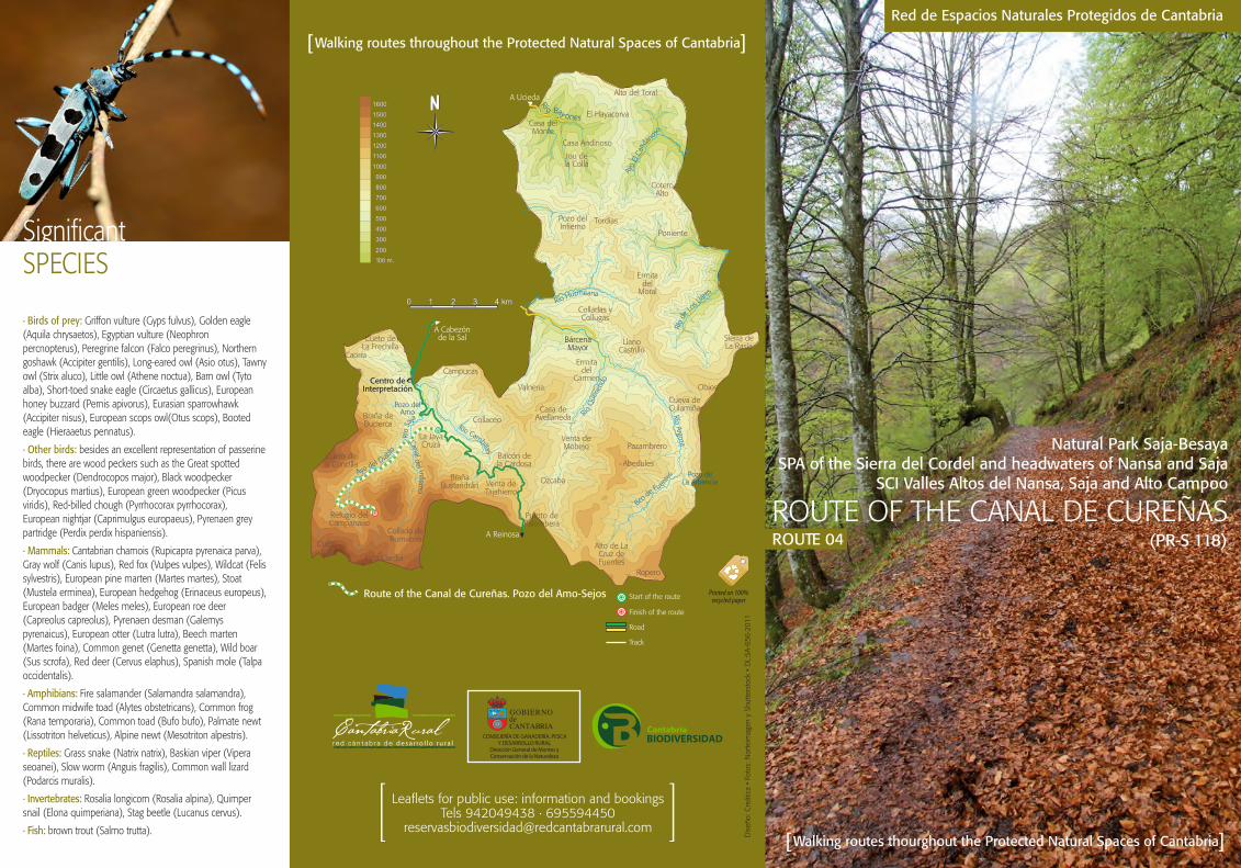
2
The recommended itinerary travels through the Reserve “Cureñas-Canal del Infierno” , and it stays inside Campoo-Cabuérniga. The route starts at Km 25 of road CA-280, Cabezón de la Sal-Reinosa, in the area known as “Jaya Cruzá” . The first part of the route nears the confluence of the rivers Bijoz and Cureñas, which is called “Tramburríos” . Following the large river Cureñas, we can see a large sessile oak (Quercus petraea) on its east bank. On the hill opposite, the rocky profiles over red sandstone of Los Molinucos del Diablo, at the foot of the Cueto La Concilla, are one of the geological attractions of the route. In the north of the beech forest, a stunted birch is faithful evidence of the adaptive capabilities of this species in the roof of the Cantabrian forest. The access to Puertos de Sejos through Sel del Abedul affords a wide panoramic view of the North face of the Sierra del Cordel, and its pastures with a wide spectrum of heather, peat, broom and fens. In this habitat amphibians are often seen in ponds and creeks as well as every once in a while brown bears (Ursus arctos), which travel to the forests looking for food. Over the top of the broom, which replaces the subalpine forest, appears the prairie, generated by man through several centuries of farming. It is known that at least since the first Medieval Age the farmers from the Cabuérniga area would use each other’s pastures in a system of transterminance. The visit includes a final walk around the pastures of Cantos de la Borrica, and the pass of Sejos, which separates the pastures from the valley of Polaciones. Furthermore a group of engraved menhirs, which are a fantastic example of the megalithic phenomenom dating back to the end of the calcolithic period (2500-1800 a. C), which is the oldest evidence of human presence in the Saja-Besaya Natural Park. Itinerary DESCRIPTION Route of the CANAL DE CUREÑAS 1 2 3 4 5 6 7 8 1.] Tramburríos 2.] Puente de la Robleda 3.] Golden eagle (Aquila chrysaetos) 4.] Canal de Cureñas 5.] Path way in the surroundings of Pozo del Amo 6.] Beech sprout (Fagus sylvatica) 7.] Stag beetle (Lucanus cervus) 8.] Sprint scene in the beech forest CARTOGRAPHY Cartography: Mapa Topográfico Nacional (IGN) Escala 1:25.000 Hojas 82-II Los Tojos y 82-III Valdeprado . Proyección UTM, Huso 30N Longitudinal profile of the route: 0.00 1.00 1.00 2.00 3.00 4.00 5.00 6.00 7.00 8.00 9.00 1600 1500 1400 1300 1200 1100 1000 900 800 700 600 Jaya Cruzá Tramburríos Molinucos del Diablo Menhires de Sejos Duration 7 h (return trip) Height gained 864 m Height lost 864 m Cumulative gain (+) 920 m FACT SHEET Canal de Cureñas Place names Start and finish point: Jaya Cruzá car park Tramburríos Molinucos del Diablo Puente de la Robleda Menhires de Sejos 30 T 395548 4774366 30 T 394400 4772930 30 T 393200 4771690 30 T 391797 4771037 30 T 390004 4771354 Cumulative loss (-) 920 m Horizontal distance 18 km (return trip) Type of route linear (return trip) Type of ground path UTM Coordinates Altitude 638 m 808 m 1.149 m 1.238 m 1.534 m HABITATS 9120 4030 9380 4020* 6430 8220 8230 Atlantic acidophilous beech forests with Ilex and sometimes also Taxus in the shrublayer (Quercion roboripetraeae or Ilici-Fagenion). Dry European heaths. Forests of Ilex aquifolium. Temperate Atlantic wet heaths with Erica ciliaris and Erica tetralix. Hydrophilous tall herb fringe communities of plains and of the montane to alpine levels. Siliceous rocky slopes with chasmophytic vegetation. Siliceous rock with pioneer vegetation of the Sedo-Scleranthion or of the Sedo albi-Veronicion dillenii. Puente de la Robleda (*) Priority habitat: habitats in the European Union which the European Council has a special responsibility, due to their delicate state. Council Directive 92/43/EEC of 21 May 1992 on the conservation of natural habitats and of wild fauna and flora. ALTITUDE (m) DISTANCE (Km)