75
1
| Date post: | 21-Dec-2015 |
| Category: |
Documents |
| View: | 224 times |
| Download: | 1 times |

1

2
Semantic Sensor Web
ARC Research Network on Intelligent Sensors, Sensor Networks andInformation Processing – ISSNIP talk
Melbourne, August 1, 2008
Amit Sheth LexisNexis Ohio Eminent Scholar
Kno.e.sis Center, Wright State University
Thanks: Cory Henson and Kno.e.sis Semantic Sensor Web team

1. Motivating scenario
2. Sensor Web Enablement
3. Metadata in the domain of Sensors
4. Semantic Sensor Web
5. Prototyping the Semantic Sensor Web
Presentation Outline
4
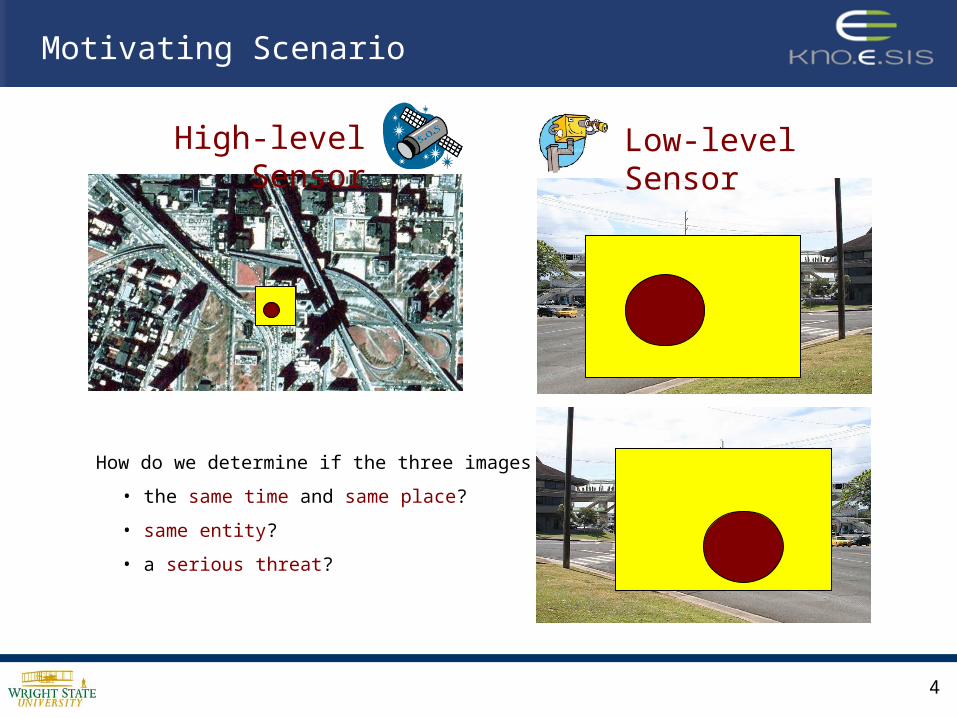
High-level Sensor
Low-level Sensor
How do we determine if the three images depict …
• the same time and same place?
• same entity?
• a serious threat?
Motivating Scenario

5
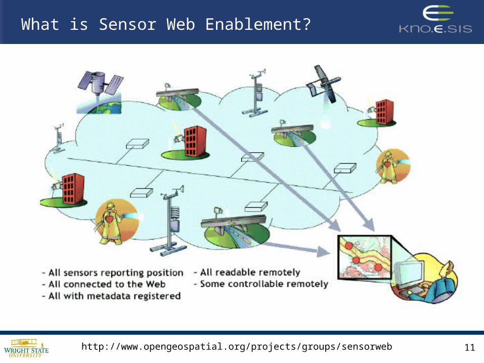
Collection and analysis of information from heterogeneous multi-layer sensor nodes
The Challenge

6
• There is a lack of uniform operations and standard representation for sensor data.
• There exists no means for resource reallocation and resource sharing.
• Deployment and usage of resources is usually tightly coupled with the specific location, application, and devices employed.
• Resulting in a lack of interoperability.
Why is this a Challenge?

Interoperability
• The ability of two or more autonomous, heterogeneous, distributed digital entities to communicate and cooperate among themselves despite differences in language, context, format or content.
• These entities should be able to interact with one another in meaningful ways without special effort by the user – the data producer or consumer – be it human or machine.

8
Survey
• GSN (Global Sensor Network, Digital Enterprise Research Institute (DERI), http://gsn.sourceforge.net/
• Hourglass (Harvard, http://www.eecs.harvard.edu/~syrah/hourglass/ )
• An Infrastructure for Connecting Sensor Networks and Applications
• IrisNet (Intel & Carnegie Mellon University, http://www.intel-iris.net/ )
• Internet-Scale Resource-Intensive Sensor Network Service
Many diverse sensor data management application frameworks were compared, such as:
These application frameworks provided only localized interoperability and that a standards-based framework was necessary.
Recent work that does follow key standard (SWE/OGC framework/standards)• SensorWeb project at University of Melbourne (http://www.gridbus.org/sensorweb/)
• 52°North's Sensor Web Community
• NASA JPL/GSFC SersorWeb, Northrop Grumman's PULSENet

The Open Geospatial ConsortiumSensor Web Enablement Framework

10
OGC MissionOGC Mission
To lead in the To lead in the development, development,
promotion and promotion and harmonization of harmonization of
open spatial open spatial standardsstandards
Open Geospatial Consortium
• Consortium of 330+ companies, government agencies, and academic institutes
• Open Standards development by consensus process
• Interoperability Programs provide end-to-end implementation and testing before spec approval
• Develop standard encodings and Web service interfaces
• Sensor Web Enablement
11
What is Sensor Web Enablement?
http://www.opengeospatial.org/projects/groups/sensorweb
12
• An interoperability framework for accessing and utilizing sensors and sensor systems in a space-time context via Internet and Web protocols
• A set of web-based services may be used to maintain a registry of available sensors and observation queries
• The same web technology standard for describing the sensors’ outputs, platforms, locations, and control parameters should be used across applications
• This standard encompasses specifications for interfaces, protocols, and encodings that enable the use of sensor data and services
What is Sensor Web Enablement?
http://www.opengeospatial.org/projects/groups/sensorweb

• Quickly discover sensors (secure or public) that can meet my needs – location, observables, quality, ability to task
• Obtain sensor information in a standard encoding that is understandable by me and my software
• Readily access sensor observations in a common manner, and in a form specific to my needs
• Subscribe to and receive alerts when a sensor measures a particular phenomenon
Sensor Web Enablement Desires

Network ServicesNetwork Services
Vast set of users and applicationsConstellations of heterogeneous sensors
Weather
ChemicalDetectors
BiologicalDetectors
Sea State
Surveillance
Airborne
Satellite
• Distributed self-describing sensors and related services
• Link sensors to network and network-centric services
• Common XML encodings, information models, and metadata for sensors and observations
• Access observation data for value added processing and decision support applications
Sensor Web Enablement
OGC Sensor Web Enablement
http://www.opengeospatial.org/projects/groups/sensorweb

GeographyML (GML)
TransducerML (TML)
Observations &
Measurements (O&M)
Information Model for Observations and Sensing
Sensor and Processing Description Language
Multiplexed, Real Time Streaming Protocol
Common Model for
Geographical Information
SensorML (SML)
Sam Bacharach, “GML by OGC to AIXM 5 UGM,” OGC, Feb. 27, 2007.
SWE Components - Languages

• Sensor Model Language (SensorML) – Standard models and XML Schema for describing sensors systems and processes; provides information needed for discovery of sensors, location of sensor observations, processing of low-level sensor observations, and listing of taskable properties
• Transducer Model Language (TransducerML) – The conceptual model and XML Schema for describing transducers and supporting real-time streaming of data to and from sensor systems
• Observations and Measurements (O&M) – Standard models and XML Schema for encoding observations and measurements from a sensor, both archived and real-time
SWE Components - Languages

CatalogService
SOS
SAS
SPS
Clients
Access Sensor Description and
Data
Command and Task Sensor
Systems
Dispatch Sensor Alerts to
registered Users
Discover Services, Sensors,
Providers, Data
Accessible from various types of
clients from PDAs and Cell Phones to
high end Workstations
Sam Bacharach, “GML by OGC to AIXM 5 UGM,” OGC, Feb. 27, 2007.
SWE Components – Web Services

• Sensor Observation Service (SOS) – Standard Web service interface for requesting, filtering, and retrieving observations and sensor system information. This is the intermediary between a client and an observation repository or near real-time sensor channel
• Sensor Alert Service (SAS) – Standard Web service interface for publishing and subscribing to alerts from sensors
• Sensor Planning Service (SPS) – Standard Web service interface for requesting user-driven acquisitions and observations. This is the intermediary between a client and a sensor collection management environment
• Web Notification Service (WNS) – Standard Web service interface for asynchronous delivery of messages or alerts from SAS and SPS web services and other elements of service workflows
SWE Components – Web Services

Applications
Sensor TypesRegistryService
Units of Measure
Phenomena
OGC Catalog Service for the Web (CSW)
SWE Components - Dictionaries
Sam Bacharach, “GML by OGC to AIXM 5 UGM,” OGC, Feb. 27, 2007.

20
Sensor Model Language(SensorML)

• SensorML is an XML schema for defining the geometric, dynamic, and observational characteristics of a sensor
• The purpose of the sensor description: 1. provide general sensor information in support of data discovery2. support the processing and analysis of the sensor measurements3. support the geolocation of the measured data. 4. provide performance characteristics (e.g. accuracy, threshold, etc.)5. archive fundamental properties and assumptions regarding sensor
• SensorML provides functional model for sensor, not detail description of hardware
• SensorML separates the sensor from its associated platform(s) and target(s)
SensorML Overview

22
• Designed to support a wide range of sensors– Including both dynamic and stationary platforms– Including both in-situ and remote sensors
• Examples:– Stationary, in-situ – chemical “sniffer”, thermometer, gravity meter– Stationary, remote – stream velocity profiler, atmospheric profiler,
Doppler radar– Dynamic, in-situ – aircraft mounted ozone “sniffer”, GPS unit,
dropsonde– Dynamic, remote – satellite radiometer, airborne camera, soldier-
mounted video
Scope of SensorML Support

23
Information provided by SensorML
• Observation characteristics– Physical properties measured (e.g. radiometry, temperature, concentration,
etc.)– Quality characteristics (e.g. accuracy, precision)– Response characteristics (e.g. spectral curve, temporal response, etc.)
• Geometry Characteristics– Size, shape, spatial weight function (e.g. point spread function) of individual
samples– Geometric and temporal characteristics of sample collections (e.g. scans or
arrays)
• Description and Documentation– Overall information about the sensor– History and reference information supporting the SensorML document

Mike Botts, "SensorML and Sensor Web Enablement," Earth System Science Center, UAB Huntsville
SML Concepts – Sensor

Mike Botts, "SensorML and Sensor Web Enablement," Earth System Science Center, UAB Huntsville
SML Concepts – Sensor Description

SML Concepts –Accuracy and Range
Mike Botts, "SensorML and Sensor Web Enablement," Earth System Science Center, UAB Huntsville

Mike Botts, "SensorML and Sensor Web Enablement," Earth System Science Center, UAB Huntsville
SML Concepts –Platform

SML Concepts – Process Model
• In SensorML, everything is modeled as a Process
• ProcessModel – defines atomic process modules
(detector being one)– has five sections
• metadata • inputs, outputs,
parameters • method
– Inputs, outputs, and parameters defined using SWE Common data definitions
Mike Botts, "SensorML and Sensor Web Enablement," Earth System Science Center, UAB Huntsville

SML Concepts – Process
• Process– defines a process chain– includes:
• metadata• inputs, outputs, and
parameters• processes (ProcessModel,
Process)• data sources• connections between
processes and between processes and data
• System– defines a collection of related
processes along with positional information
Mike Botts, "SensorML and Sensor Web Enablement," Earth System Science Center, UAB Huntsville

SML Concepts –Metadata Group
• Metadata is primarily for discovery and assistance, and not typically used within process execution
• Includes– Identification, classification,
description– Security, legal, and time
constraints– Capabilities and characteristics– Contacts and documentation– History
Mike Botts, "SensorML and Sensor Web Enablement," Earth System Science Center, UAB Huntsville

SML Concepts – Event
Mike Botts, "SensorML and Sensor Web Enablement," Earth System Science Center, UAB Huntsville

«FeatureType»Observ ation
+ quality: DQ_Element [0..1]+ responsible: CI_ResponsibleParty [0..1]+ result: Any
«FeatureType»Event
+ eventParameter: TypedValue [0..*]+ time: TM_Object
«DataType»TypedValue
+ property: ScopedName+ value: Any
«Union»Procedure
+ procedureType: ProcedureSystem+ procedureUse: ProcedureEvent
AnyIdentifiableObject
«FeatureType»AnyIdentifiableFeature
AnyDefinition
«ObjectType»Phenomenon
+followingEvent 0..*+precedingEvent 0..*
+generatedObservation
0..*
+procedure 1
+observedProperty1{Definition must be of aphenomenon that is a propertyof the featureOfInterest}
+propertyValueProvider
0..*
+featureOfInterest
1
An Observation is an Event whose result is an estimate of the value of some Property of the Feature-of-interest, obtained using a specified Procedure
The Feature-of-interest concept reconciles remote and in-situ observations
Example: Observation
Mike Botts, "SensorML and Sensor Web Enablement," Earth System Science Center, UAB Huntsville

1. Motivating scenario
2. Sensor Web Enablement
3. Metadata in the domain of Sensors
4. Semantic Sensor Web
5. Prototyping the Semantic Sensor Web
Presentation Outline
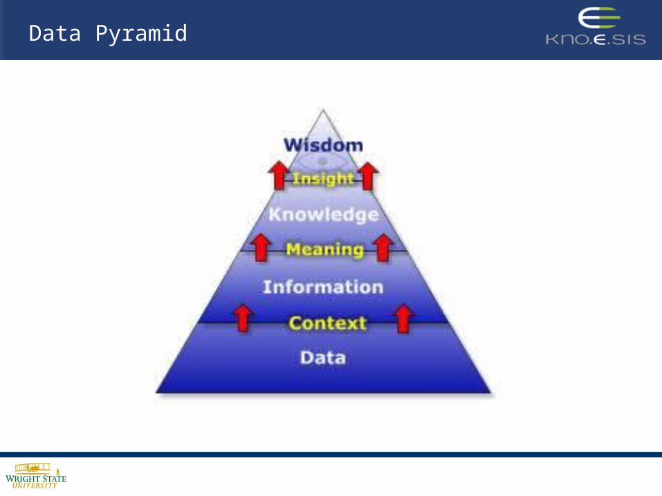
Data Pyramid

Sensor Data Pyramid
Raw Sensor (Phenomenological) Data
Feature Metadata
Entity Metadata
Ontology Metadata
Expr
essi
vene
ss
Data
Information
Knowledge
Data Pyramid

Sensor Data Pyramid
Raw Sensor Raw Sensor DataData
Ontology Metadata
Entity Metadata
Feature Metadata
• Avalanche of data
• Streaming data
• Multi-modal/level data fusion
• Lack of interoperability
(e.g., binary images, streaming video, etc.)

Sensor Data Pyramid
Raw Sensor Data
Ontology Metadata
Entity Metadata
Feature MetadataFeature Metadata
• Extract features from data
• Annotate data with feature metadata
• Store and query feature metadata
(e.g., lines, color, texture, etc.)

Sensor Data Pyramid
Raw Sensor Data
Ontology Metadata
Entity MetadataEntity Metadata
Feature Metadata
• Detect objects-events from features
• Annotate data with objects-event metadata
• Store and query objects-events
(e.g., objects and events such as cars driving)

Sensor Data Pyramid
Raw Sensor Data
Ontology Ontology MetadataMetadata
Entity Metadata
Feature Metadata
Discover and reason over associations:
• objects and events
• space and time
• provenance/context
(e.g., situations such as cars speeding dangerously)

1. Motivating scenario
2. Sensor Web Enablement
3. Metadata in the domain of Sensors
4. Semantic Sensor Web
5. Prototyping the Semantic Sensor Web
Presentation Outline

41
Semantic Sensor Web
What is the Semantic Sensor Web? • Adding semantic annotations to existing standard
Sensor Web languages in order to provide semantic descriptions and enhanced access to sensor data
• This is accomplished with model-references to ontology concepts that provide more expressive concept descriptions

42
Semantic Sensor Web
What is the Semantic Sensor Web?
• For example, – using model-references to link O&M annotated sensor
data with concepts within an OWL-Time ontology allows one to provide temporal semantics of sensor data
– using a model reference to annotate sensor device ontology enables uniform/interoperable characterization/descriptions of sensor parameters regardless of different manufactures of the same type of sensor and their respective proprietary data representations/formats

Standards Organizations
OGC Sensor Web Enablement• SensorML
• O&M
• TransducerML
• GeographyML
Web Services• Web Services Description Language
• REST
National Institute for Standards and Technology
• Semantic Interoperability Community of Practice
• Sensor Standards Harmonization
W3C Semantic Web• Resource Description Framework
• RDF Schema
• Web Ontology Language
• Semantic Web Rule Language
• SAWSDL*
• SA-REST
• SML-S
• O&M-S
• TML-S
Sensor Ontology
Sensor Ontology
* SAWSDL - now a W3C Recommendation is based on our work.

44
Semantic Sensor Web

45
Semantic Annotation
RDFa
• Used for semantically annotating XML documents. • Several important attributes within RDFa include:
– about: describes subject of the RDF triple– rel: describes the predicate of the RDF triple– resource: describes the object of the RDF triple– instanceof: describes the object of the RDF triple with the
predicate as “rdf:type”
Other used Model Reference in Semantic Annotations• SAWSDL: Defines mechanisms to add semantic
annotations to WSDL and XML-Schema components (W3C Recommendation)
• SA-REST: Defines mechanisms to add semantic annotations to REST-based Web services.
W3C, RDFa, http://www.w3.org/TR/rdfa-syntax/

46
Semantically Annotated O&M
<swe:component name="time"><swe:Time definition="urn:ogc:def:phenomenon:time" uom="urn:ogc:def:unit:date-
time"><sa:swe rdfa:about="?time" rdfa:instanceof="time:Instant">
<sa:sml rdfa:property="xs:date-time"/></sa:swe>
</swe:Time></swe:component><swe:component name="measured_air_temperature">
<swe:Quantity definition="urn:ogc:def:phenomenon:temperature“ uom="urn:ogc:def:unit:fahrenheit">
<sa:swe rdfa:about="?measured_air_temperature“ rdfa:instanceof=“senso:TemperatureObservation">
<sa:swe rdfa:property="weather:fahrenheit"/><sa:swe rdfa:rel="senso:occurred_when" resource="?time"/><sa:swe rdfa:rel="senso:observed_by"
resource="senso:buckeye_sensor"/></sa:sml>
</swe:Quantity></swe:component>
<swe:value name=“weather-data">2008-03-08T05:00:00,29.1
</swe:value>

47
Semantically Annotated O&M
<swe:component name="time"><swe:Time definition="urn:ogc:def:phenomenon:time" uom="urn:ogc:def:unit:date-
time"><sa:swe rdfa:about="?time" rdfa:instanceof="time:Instant">
<sa:sml rdfa:property="xs:date-time"/></sa:swe>
</swe:Time></swe:component><swe:component name="measured_air_temperature">
<swe:Quantity definition="urn:ogc:def:phenomenon:temperature“ uom="urn:ogc:def:unit:fahrenheit">
<sa:swe rdfa:about="?measured_air_temperature“ rdfa:instanceof=“senso:TemperatureObservation">
<sa:swe rdfa:property="weather:fahrenheit"/><sa:swe rdfa:rel="senso:occurred_when" resource="?time"/><sa:swe rdfa:rel="senso:observed_by"
resource="senso:buckeye_sensor"/></sa:sml>
</swe:Quantity></swe:component>
<swe:value name=“weather-data">2008-03-08T05:00:00,29.1
</swe:value>

48
Semantically Annotated O&M
<swe:component name="time"><swe:Time definition="urn:ogc:def:phenomenon:time" uom="urn:ogc:def:unit:date-
time"><sa:swe rdfa:about="?time" rdfa:instanceof="time:Instant">
<sa:sml rdfa:property="xs:date-time"/></sa:swe>
</swe:Time></swe:component><swe:component name="measured_air_temperature">
<swe:Quantity definition="urn:ogc:def:phenomenon:temperature“ uom="urn:ogc:def:unit:fahrenheit">
<sa:swe rdfa:about="?measured_air_temperature“ rdfa:instanceof=“senso:TemperatureObservation">
<sa:swe rdfa:property="weather:fahrenheit"/><sa:swe rdfa:rel="senso:occurred_when" resource="?time"/><sa:swe rdfa:rel="senso:observed_by"
resource="senso:buckeye_sensor"/></sa:sml>
</swe:Quantity></swe:component>
<swe:value name=“weather-data">2008-03-08T05:00:00,29.1
</swe:value>
?time rdf:type time:Instant?time xs:date-time "2008-03-08T05:00:00"
?measured_air_temperature rdf:type senso:TemperatureObservation?measured_air_temperature weather:fahrenheit "29.1"?measured_air_temperature senso:occurred_when ?time?measured_air_temperature senso:observed_by senso:buckeye_sensor

49
Semantic Query
Semantic Temporal Query
• Model-references from SML to OWL-Time ontology concepts provides the ability to perform semantic temporal queries
• Supported semantic query operators include:– contains: user-specified interval falls wholly within a sensor
reading interval (also called inside)– within: sensor reading interval falls wholly within the user-
specified interval (inverse of contains or inside)– overlaps: user-specified interval overlaps the sensor reading
interval• Example SPARQL query defining the temporal operator ‘within’

50
Data
• Raw Phenomenological Data
Semantic Sensor Data-to-Knowledge Architecture
Information
• Entity Metadata
• Feature Metadata
Knowledge
• Object-Event Relations
• Spatiotemporal Associations
• Provenance/Context
Feature Extraction and Entity Detection
Data Storage(Raw Data, XML, RDF)
Semantic Analysis and Query
Sensor Data Collection
Ontologies• Space Ontology
• Time Ontology
• Situation Theory Ontology
• Domain Ontology
SemanticAnnotation

1. Motivating scenario
2. Sensor Web Enablement
3. Metadata in the domain of Sensors
4. Semantic Sensor Web
5. Prototyping the Semantic Sensor Web
Presentation Outline

52
Application 1: Temporal Semantics for Video Sensor Data
• Semantically annotated police cruiser videos collected from YouTube with model references to an OWL-Time ontology
• Enables time-interval based queries, such as contains, within, overlaps
Prototyping the Semantic Sensor Web

5353
Storage Query
Extraction & Metadata Creation
VideoConversion
Filtering& OCR
SML AnnotationGeneration
Time & Dateinformation
ConvertedVideos
SML(XML-DB)
Ontology(OWL/RDF-DB)
UI
SML Interface
OntologyInterface
AVI
OWL-Time AnnotationGeneration
Google Maps
GWT(Java to Ajax)
Temporal Semantics for Video Sensor Data
Data Collection
Data Source(e.g., YouTube)

5454
Temporal Semantics for Video Sensor Data
Optical Character Recognition (OCR)– Feature Extraction– Temporal Entity Recognition– Metadata Generation & Semantic annotation

5555
Demo: Temporal Semantics for Video Sensor Data
Demo: http://knoesis.wright.edu/library/demos/ssw/prototype.htm

56
Application 2: Semantic Sensor Observation Service
• Semantically annotated weather data collected from BuckeyeTraffic.org with model references to an OWL-Time ontology, geospatial ontology, and weather ontology
• Capable of multi-level weather queries and inferences on a network of multi-modal sensors
Prototyping the Semantic Sensor Web

57
Ontology & Rules
• Weather
• Time
• Space
OracleSensorDB
Get Observation
Describe Sensor
Semantic Sensor Observation Service
Collect Sensor Data
BuckeyeTraffic.org
Get Capabilities
SA-SML Annotation Service
S-SOS Client
SWE Annotated SWE
HTTP-GET Request
O&M-S or SML-S Response
SOS-S Architecture
58
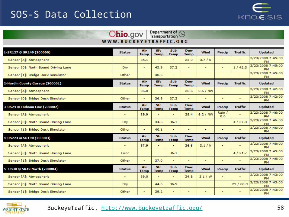
SOS-S Data Collection
BuckeyeTraffic, http://www.buckeyetraffic.org/
59
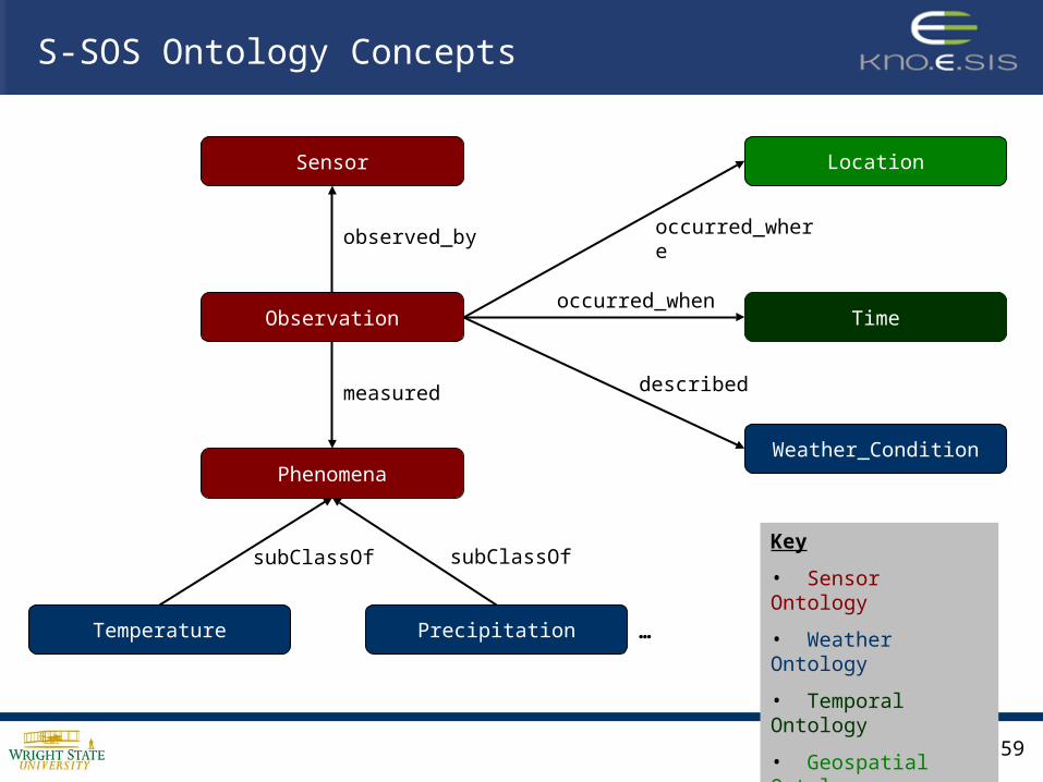
Observation
Sensor
Phenomena
Time
Location
Weather_Condition
Temperature Precipitation
observed_by
measured
occurred_when
occurred_where
described
subClassOf subClassOfKey
• Sensor Ontology
• Weather Ontology
• Temporal Ontology
• Geospatial Ontology
S-SOS Ontology Concepts
…

60
Icy
Blizzard
Weather_Condition
Wet
S-SOS Ontology Concepts
Freezing
Potentially Icy
subClassOf
Instances of simple weather conditions created directly from BuckeyeTraffic data
Instances of complex weather conditions inferred through rules

61
S-SOS Rules for Weather Conditions
Example Potential_Ice_with_Rain_and_Celcius_Temp
Observation(?obs) ^measured(?obs, ?precip) ^Rain(?precip) ^measured(?obs, ?temp) ^Temperature(?temp) ^temperature_value(?temp, ?tval) ^lessThanOrEqual(?tval, 0) ^unit_of_measurement(?temp, “celcius") → described(?obs, Potential_Ice)
• Blizzard
• Potential Ice
• Freezing
• etc.
• Rules allow inferred knowledge from the sensor data• For example: Based on temperature, wind speed,
precipitation, etc., we can infer the “potential” road condition the type of storm being observed

62
SOS-S Client
Get Observation
Describe Sensor
Semantic Sensor Observation Service
Get Capabilities
HTTP-GET Request
http://knoesis1.wright.edu/weather/weather?service=SOS&version=1.0&request=GetObservation&offering=WEATHER_DATA&format=application/com-xml&time=2008-03-08T05:00:00Z/2008-03-08T06:00:00Z &interval_type=within&weather_condition=potentially_icy
O&M-S Response
<swe:Time definition="urn:ogc:def:phenomenon:time" uom="urn:ogc:def:unit:date-time">
<sa:swe rdfa:about="?time“rdfa:instanceof="time:Instant">
<sa:sml rdfa:property="xs:date-time"/></sa:swe>
</swe:Time><swe:value name=“weather-data">
2008-03-08T05:00:00,29.1</swe:value>

63
SOS-S Client
Get Observation
Describe Sensor
Semantic Sensor Observation Service
Get Capabilities
HTTP-GET Request
http://knoesis1.wright.edu/weather/weather?service=SOS&version=1.0&request=GetObservation&offering=WEATHER_DATA&format=application/com-xml&time=2008-03-08T05:00:00Z/2008-03-08T06:00:00Z &interval_type=within&weather_condition=potentially_icy
O&M-S Response
<swe:Time definition="urn:ogc:def:phenomenon:time" uom="urn:ogc:def:unit:date-time">
<sa:swe rdfa:about="?time“rdfa:instanceof="time:Instant">
<sa:sml rdfa:property="xs:date-time"/></sa:swe>
</swe:Time><swe:value name=“weather-data">
2008-03-08T05:00:00,29.1</swe:value>

64
Demo: Semantic Sensor Observation Service
Demo: http://knoesis.wright.edu/research/semsci/application_domain/sem_sensor/afrl/demo/ssw.html

Spatial, Temporal, Thematic Analyticswithin the Semantic Sensor Web

66
Value to Sensor Networks
• Simple (Analyze Infrastructure):– What types of sensors are available?– What sensors can observe a particular phenomenon at a given
geolocation?– Get all observations for a particular geolocation during a
given time interval.
• Complex (More background thematic information):– How do I detect weather events from observation data?– What do I know about the buildings (georeferenced) in this
image?– Which sensors cover an area which intersects with a planned
event?

67
Challenges
• Data Modeling and Querying:– Thematic relationships can be directly stated
but many spatial and temporal relationships (e.g. distance) are implicit and require additional computation
– Temporal properties of paths aren’t known until query execution time … hard to index
• RDFS Inferencing:– If statements have an associated valid time this
must be taken into account when performing inferencing
– (x, rdfs:subClassOf, y) : [1, 4] AND (y, rdfs:subClassOf, z) : [3, 5] (x, rdfs:subClassOf, z) : [3, 4]

68
Work to Date
• Ontology-based model for spatiotemporal data using temporal RDF 1
– Illustrated benefits in flexibility, extensibility and expressiveness as compared with existing spatiotemporal models used in GIS
• Definition, implementation and evaluation of corresponding query operators using an extensible DBMS (Oracle) 2
– Created SQL Table Functions which allow SPARQL graph patterns in combination with Spatial and Temporal predicates over Temporal RDF graphs
1. Matthew Perry, Farshad Hakimpour, Amit Sheth. "Analyzing Theme, Space and Time: An Ontology-based Approach", Fourteenth International Symposium on Advances in Geographic Information Systems (ACM-GIS '06), Arlington, VA, November 10 - 11, 2006
2. Matthew Perry, Amit Sheth, Farshad Hakimpour, Prateek Jain. "What, Where and When: Supporting Semantic, Spatial and Temporal Queries in a DBMS", Kno.e.sis Center Technical Report. KNOESIS-TR-2007-01, April 22, 2007

69
Sample STT Query
Scenario (Blizzard Detection): Find all sensors that have observed a Blizzard within a 100 mile radius of a given location.
Query specifies
(1) a relationship between a sensor, observation, blizzard, and location
(2) a spatial filtering condition based on the proximity of the sensor and the defined point
select * from table (spatial_find(‘(?sensor :location ?loc) (?sensor :generatedObservation ?obs) (?obs :featureOfInterest :Blizzard)', ‘loc',
'POINT(-149.40572 61.29302)','GEO_DISTANCE(distance=100 unit=mile)‘);

70
Current Work & Future Demo
• MesoWest Dataset– 20,000 Sensor Systems predominately within United States– Archive observation data since April 2002– Building dataset of ~1 billion triples
• Trusted Sensors– Reputation based framework to detect trustworthiness of
sensors– Model-based diagnosis to detect abnormal and/or malicious
sensor behavior
• Abductive Perception– Generating explanations for sensor observations through
abductive inference and ranking– Validating explanations through deductive inference
prediction and comparison with subsequent observation data
71
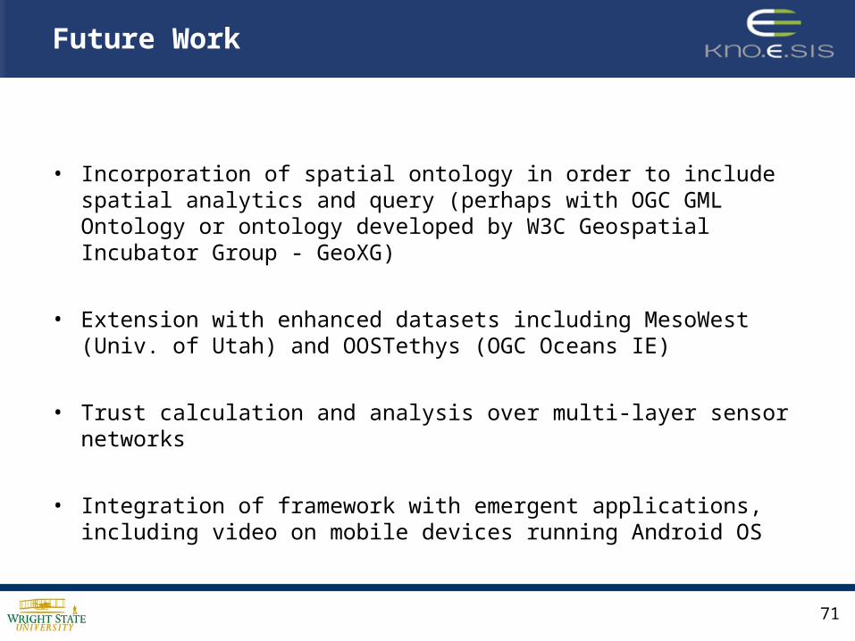
Future Work
• Incorporation of spatial ontology in order to include spatial analytics and query (perhaps with OGC GML Ontology or ontology developed by W3C Geospatial Incubator Group - GeoXG)
• Extension with enhanced datasets including MesoWest (Univ. of Utah) and OOSTethys (OGC Oceans IE)
• Trust calculation and analysis over multi-layer sensor networks
• Integration of framework with emergent applications, including video on mobile devices running Android OS

72
• Cory Henson, Amit Sheth, Prateek Jain, Josh Pschorr, Terry Rapoch, “Video on the Semantic Sensor Web,” W3C Video on the Web Workshop, December 12-13, 2007, San Jose, CA, and Brussels, Belgium
• Matthew Perry, Amit Sheth, Farshad Hakimpour, Prateek Jain. “Supporting Complex Thematic, Spatial and Temporal Queries over Semantic Web Data,” Second International Conference on Geospatial Semantics (GEOS ’07), Mexico City, MX, November 29-30, 2007
• Matthew Perry, Farshad Hakimpour, Amit Sheth. “Analyzing Theme, Space and Time: An Ontology-based Approach,” Fourteenth International Symposium on Advances in Geographic Information Systems (ACM-GIS ’06), Arlington, VA, November 10-11, 2006
• Farshad Hakimpour, Boanerges Aleman-Meza, Matthew Perry, Amit Sheth. “Data Processing in Space, Time, and Semantic Dimensions,” Terra Cognita 2006 – Directions to Geospatial Semantic Web, in conjunction with the Fifth International Semantic Web Conference (ISWC ’06), Athens, GA, November 6, 2006
• Mike Botts, George Percivall, Carl Reed, John Davidson, “OGC Sensor Web Enablement: Overview and High Level Architecture (OGC 07-165),” Open Geospatial Consortium White Paper, December 28, 2007.
• Open Geospatial Consortium, Sensor Web Enablement WG, http://www.opengeospatial.org/projects/groups/sensorweb
References
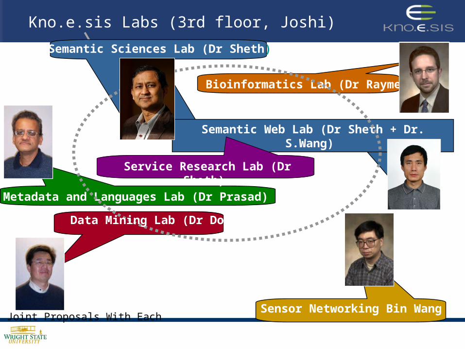
Kno.e.sis Labs (3rd floor, Joshi)
Bioinformatics Lab (Dr Raymer)
Semantic Sciences Lab (Dr Sheth)
Metadata and Languages Lab (Dr Prasad)
Semantic Web Lab (Dr Sheth + Dr. S.Wang)
Joint Proposals With Each
Data Mining Lab (Dr Dong)
Service Research Lab (Dr Sheth)
Sensor Networking Bin Wang
Kno.e.sis Members – a subset

References
Semantic Sensor Web projects: http://knoesis.org/research/semsci/application_domain/sem_sensor/
Spatio-temporal-thematic Query Processing & Reasoning: http://knoesis.org/research/semweb/projects/stt/
Demos at: http://knoesis.wright.edu/library/demos/
Publications: http://knoesis.wright.edu/library
Rest: http://knoesis.org


![S(axrtt0cq2qjpfte3tkj3ll2c))/Downloads/NNM/... · Project (ISSNIP) under World Bank Loan credit No[Credit 5150-IN] which comprise the statement of Sources and Application of Funds](https://static.documents.pub/doc/80x56/5c82f8a409d3f2e31c8cbda9/saxrtt0cq2qjpfte3tkj3ll2cdownloadsnnm-project-issnip-under-world.jpg)


![ICDS Systems Strengthening & Nutrition Improvement Project ... SIDE TABS/… · ICDS Systems Strengthening & Nutrition Improvement Project (ISSNIP) [Credit 5150-IN] Procurement Plan](https://static.documents.pub/doc/80x56/5e99bbcd7c0824755c7c4771/icds-systems-strengthening-nutrition-improvement-project-side-tabs.jpg)
