1. EVOLUTION OF THE NORWEGIAN CONTINENTAL MARGIN: BACKGROUND AND OBJECTIVES 1 Olav Eldholm, Department of Geology, University of Oslo, Oslo, Norway 2 Jorn Thiede, Geologisch-Palaontologisches Institut und Museum, Christian-Albrechts Universitat, Kiel, Federal Republic of Germany 2 and Elliott Taylor, Ocean Drilling Program, Texas A&M University, College Station, Texas 2 INTRODUCTION In a global perspective, the Norwegian-Greenland Sea offers unique opportunities to study some of the most important geo- logical phenomena of the world ocean: 1. The Norwegian-Greenland Sea is a relatively young ocean basin, formed during the past 56 m.y. by seafloor spreading and surrounded by passive continental margins. The basin is an ex- cellent laboratory for studying many features created in the ear- ly stages of passive continental margin formation. Thus, studies of these margins provide information about the processes and evolutionary history related to the transitional region between oceanic and continental crust, one of the world's most impor- tant geological boundaries. 2. The Norwegian-Greenland Sea represents the northern- most extension of the zonal Atlantic Ocean, which today per- mits the exchange of cold bottom water from both the northern and the southern polar deep-sea basins with the tropical Atlan- tic and the adjacent Indian and Pacific oceans. This process of Atlantic bottom-water formation developed during the Cenozo- ic and its evolution in the Northern Hemisphere can be studied using pelagic sediments from the Norwegian-Greenland Sea. 3. Relatively warm Atlantic water masses entered the young Norwegian-Greenland Sea after the subsidence of the Green- land-Scotland Ridge. Today, as the Norwegian Current, they trail the Norwegian continental margin until they enter the Arc- tic Ocean. The Norwegian Current has repeatedly appeared and disappeared in response to the climatic fluctuations that led to the development of the late Cenozoic inter glacials and glacials. Interglacial conditions in northwestern Europe could only de- velop during times when the Norwegian Current carried rela- tively warm water into the Norwegian Sea. The early history and variability of this current has not yet been resolved in detail, but can be studied only in the eastern Norwegian Sea. Leg 104 of the Ocean Drilling Program (ODP) set out to in- vestigate some of these problems by drilling holes at a sequence of sites along a traverse across the Voring Plateau in the eastern Norwegian Sea (Fig. 1). The drill sites have, in particular, been selected to investigate the following scientific problems: 1. Age and nature of a sequence of dipping reflectors, a for- mation of probable volcanic origin that has been observed along many different passive continental margins. This type of se- quence appears to be intimately related to the evolution of mar- ginal highs during the early stages of passive-margin formation. 1 Eldholm, O., Thiede, J., and Taylor, E., et al., 1987. Proc, Init. Repts. (Pt. A), ODP, 104. 2 Addresses: (Eldholm) Department of Geology, University of Oslo, P.O. Box 1047, Blindern, Oslo 3, N-0316, Norway; (Thiede) Geologisch-Palaontologisches Institut und Museum, Christian-Albrechts-Universitat, Olshausenstr. 40, D-2300 Kiel, Federal Republic of Germany; (Taylor) Ocean Drilling Program, Texas A&M University, College Station, TX 77840. 2. Age and nature of the basement below the dipping-reflec- tor sequence. Coring at this level might provide means to resolve the question of whether the dipping-reflector sequence is overly- ing an oceanic or continental type of basement. 3. Subsidence and depositional history of a passive conti- nental margin exhibiting a marginal high (in the polar/subpolar realm). 4. Paleoceanographic history of the Norwegian-Greenland Sea, in particular of the Norwegian Current as a continuation of the Gulf Stream system into the northern polar deep-sea ba- sins. 5. Cenozoic paleoclimatic history of the Northern Hemi- sphere, with particular emphasis on the initiation and variabili- ty of Northern Hemisphere glaciation. 6. Cenozoic evolution of pelagic floras and faunas in re- sponse to the paleoclimatic and paleoceanographic processes in the Norwegian-Greenland Sea, including comparison with Southern Hemisphere pelagic fossil records. CONTINENTAL MARGIN OFF NORWAY In terms of bathymetry, morphology, and structural elements, the Norwegian continental margin between 62° and 70°N (Fig. 1) may be considered as consisting of three main units, the Mdre, Wring, and Lofoten-Vesteralen margin provinces (Figs. 2 and 3). As seen from Figure 2 these provinces are recognized mor- phologically by the varying width of the shelf and the slope gra- dient. Off central Norway, the bulbous marginal Wring Plateau breaks the slope bathymetry at a depth of 1000 to 1500 m. This spectacular feature, covering an area of about 35,000 km 2 , is bounded by an outer slope toward the Lofoten Basin in the north and the Norway Basin in the southwest defined by the 1500- and 2500-m contours. The oldest part of the East Jan Mayen Frac- ture Zone constitutes the southwestern flank of the plateau. Buried basement highs exist beneath the outer parts of the Mrire and Wring margins. These marginal highs mark the sea- ward extension of major regional sedimentary basins at the con- tinental shelf and slope off Norway. The Faeroe-Shetland and the Wring marginal highs terminate the Mdre and Wring ba- sins, respectively. The highs and basins are offset about 200 km along the East Jan Mayen Fracture Zone. In the north, the Wr- ing Basin rises toward the structurally elevated Lofoten-Vestera- len shelf. Many structures at, or in the vicinity of, marginal highs on passive margins are related to the breakup of the continental crust during the latest rift or earliest seafloor-spreading stage associated with the development of a deep ocean. The nature of such features is not fully understood, however. Because the Wr- ing marginal high underlying the outer Wring Plateau is buried at a relatively shallow depth, and therefore accessible by drill- ing, it was chosen as a target area to study problems related to the early formation of a passive continental margin. 5
Transcript
1. EVOLUTION OF THE NORWEGIAN CONTINENTAL MARGIN: BACKGROUND AND OBJECTIVES1
Olav Eldholm, Department of Geology, University of Oslo, Oslo, Norway2
Jorn Thiede, Geologisch-Palaontologisches Institut und Museum, Christian-Albrechts Universitat, Kiel, Federal Republic of Germany2
and Elliott Taylor, Ocean Drilling Program, Texas A&M University, College Station, Texas2
INTRODUCTION
In a global perspective, the Norwegian-Greenland Sea offers unique opportunities to study some of the most important geological phenomena of the world ocean:
1. The Norwegian-Greenland Sea is a relatively young ocean basin, formed during the past 56 m.y. by seafloor spreading and surrounded by passive continental margins. The basin is an excellent laboratory for studying many features created in the early stages of passive continental margin formation. Thus, studies of these margins provide information about the processes and evolutionary history related to the transitional region between oceanic and continental crust, one of the world's most important geological boundaries.
2. The Norwegian-Greenland Sea represents the northernmost extension of the zonal Atlantic Ocean, which today permits the exchange of cold bottom water from both the northern and the southern polar deep-sea basins with the tropical Atlantic and the adjacent Indian and Pacific oceans. This process of Atlantic bottom-water formation developed during the Cenozo-ic and its evolution in the Northern Hemisphere can be studied using pelagic sediments from the Norwegian-Greenland Sea.
3. Relatively warm Atlantic water masses entered the young Norwegian-Greenland Sea after the subsidence of the Greenland-Scotland Ridge. Today, as the Norwegian Current, they trail the Norwegian continental margin until they enter the Arctic Ocean. The Norwegian Current has repeatedly appeared and disappeared in response to the climatic fluctuations that led to the development of the late Cenozoic inter glacials and glacials. Interglacial conditions in northwestern Europe could only develop during times when the Norwegian Current carried relatively warm water into the Norwegian Sea. The early history and variability of this current has not yet been resolved in detail, but can be studied only in the eastern Norwegian Sea.
Leg 104 of the Ocean Drilling Program (ODP) set out to investigate some of these problems by drilling holes at a sequence of sites along a traverse across the Voring Plateau in the eastern Norwegian Sea (Fig. 1). The drill sites have, in particular, been selected to investigate the following scientific problems:
1. Age and nature of a sequence of dipping reflectors, a formation of probable volcanic origin that has been observed along many different passive continental margins. This type of sequence appears to be intimately related to the evolution of marginal highs during the early stages of passive-margin formation.
1 Eldholm, O., Thiede, J., and Taylor, E., et al., 1987. Proc, Init. Repts. (Pt. A), ODP, 104.
2 Addresses: (Eldholm) Department of Geology, University of Oslo, P.O. Box 1047, Blindern, Oslo 3, N-0316, Norway; (Thiede) Geologisch-Palaontologisches Institut und Museum, Christian-Albrechts-Universitat, Olshausenstr. 40, D-2300 Kiel, Federal Republic of Germany; (Taylor) Ocean Drilling Program, Texas A&M University, College Station, TX 77840.
2. Age and nature of the basement below the dipping-reflector sequence. Coring at this level might provide means to resolve the question of whether the dipping-reflector sequence is overlying an oceanic or continental type of basement.
3. Subsidence and depositional history of a passive continental margin exhibiting a marginal high (in the polar/subpolar realm).
4. Paleoceanographic history of the Norwegian-Greenland Sea, in particular of the Norwegian Current as a continuation of the Gulf Stream system into the northern polar deep-sea basins.
5. Cenozoic paleoclimatic history of the Northern Hemisphere, with particular emphasis on the initiation and variability of Northern Hemisphere glaciation.
6. Cenozoic evolution of pelagic floras and faunas in response to the paleoclimatic and paleoceanographic processes in the Norwegian-Greenland Sea, including comparison with Southern Hemisphere pelagic fossil records.
CONTINENTAL MARGIN OFF NORWAY In terms of bathymetry, morphology, and structural elements,
the Norwegian continental margin between 62° and 70°N (Fig. 1) may be considered as consisting of three main units, the Mdre, Wring, and Lofoten-Vesteralen margin provinces (Figs. 2 and 3).
As seen from Figure 2 these provinces are recognized morphologically by the varying width of the shelf and the slope gradient. Off central Norway, the bulbous marginal Wring Plateau breaks the slope bathymetry at a depth of 1000 to 1500 m. This spectacular feature, covering an area of about 35,000 km2, is bounded by an outer slope toward the Lofoten Basin in the north and the Norway Basin in the southwest defined by the 1500- and 2500-m contours. The oldest part of the East Jan Mayen Fracture Zone constitutes the southwestern flank of the plateau.
Buried basement highs exist beneath the outer parts of the Mrire and Wring margins. These marginal highs mark the seaward extension of major regional sedimentary basins at the continental shelf and slope off Norway. The Faeroe-Shetland and the Wring marginal highs terminate the Mdre and Wring basins, respectively. The highs and basins are offset about 200 km along the East Jan Mayen Fracture Zone. In the north, the Wring Basin rises toward the structurally elevated Lofoten-Vesteralen shelf.
Many structures at, or in the vicinity of, marginal highs on passive margins are related to the breakup of the continental crust during the latest rift or earliest seafloor-spreading stage associated with the development of a deep ocean. The nature of such features is not fully understood, however. Because the Wring marginal high underlying the outer Wring Plateau is buried at a relatively shallow depth, and therefore accessible by drilling, it was chosen as a target area to study problems related to the early formation of a passive continental margin.
5
O. ELDHOLM, J. THIEDE, E. TAYLOR
30°W 30°E
Figure 1. Regional bathymetry (contour interval, 500 fm) and main structural features of the Norwegian-Greenland Sea, based on Talwani and Eldholm (1977). GE, JMR, VP, I-FR, and NB refer to Greenland Escarpment, Jan May-en Ridge, Vriring Plateau, Iceland-Faeroe Ridge, and Norway Basin, respectively.
Plate-Tectonic Summary
Since the Carboniferous, the structural history of the margin has been dominated by several rifting events until crustal separation between Norway and Greenland was achieved close to the Paleocene/Eocene boundary. Seismic data tied to drill-site information indicate that the region between Norway and Greenland has been a depositional area at least since the Carboniferous (Remnevik et al., 1983). Sedimentation started on an epeiro-genic subsiding post-Caledonian surface. In late Paleozoic time a tectonic phase created a system of rotated fault blocks with sedimentation filling in the fault-bounded basins. From late Paleozoic to early Mesozoic time sedimentation gradually smoothed the relief, forming a large regional basin in Early Jurassic time. A new main phase of extensional tectonics, Kimmerian, which started in Middle and culminated in Late Jurassic time, formed a system of basins and ridges (Fig. 3). During Cretaceous and into Paleocene time the relief was again smoothed by marine
sedimentation and regional subsidence in large epicontinental basins.
In earliest Tertiary time, seafloor spreading occurred along a plate boundary in the North Atlantic, continuing into the Labrador Sea. The crust between Norway and Greenland, which had been subjected to several tensional phases in Mesozoic time without complete crustal breakup, was again being thinned with generation of oceanic crust commencing during the negative polarity interval between anomalies 24B and 25 (Talwani and Eldholm, 1977).
Subsequent to the start of seafloor spreading the incipient ocean between Norway and Greenland gradually widened and deepened. However, the present distribution of oceanic ridges and fracture zones in the Norwegian-Greenland Sea reflects a rather complex plate-tectonic history (Talwani and Eldholm, 1977; Nunns and Peacock, 1982; Myhre et al., 1982). The Ceno-zoic history of the continental margin is closely related to the plate-tectonic development, characterized by two major evolu-
6
BACKGROUND AND OBJECTIVES
63°N
Marginal escarpment
1°W 0° 1°E 5° 10° 14°E
Figure 2. Bathymetry of the Norwegian continental margin, 60°-70°N (contour interval, 100 fm). Map modified from Mutter et al. (1984).
tionary phases and by local migration of the plate boundary (Fig. 4).
During the first main evolutionary phase, between anomalies 25/24B and 13, Greenland moved in a north-northwest direction relative to Eurasia. A major change in the pole of rotation at about the time of anomaly 13 caused the movement of Greenland relative to Eurasia to become almost west-northwest. These
directions are clearly expressed in the azimuths of the fracture zones. The change is associated with the cessation of spreading in the Labrador Sea when Greenland became part of the North American Plate (Kristoffersen and Talwani, 1977; Srivastava, 1978).
The two major fracture zone systems, Jan Mayen and Green-land-Senja (Fig. 1) transecting the Norwegian-Greenland Sea,
7
O. ELDHOLM, J. THIEDE, E. TAYLOR
1 Location of type section ■■■■■■■■mi Landward boundary of flows . . . . . . Shelf edge — — Magnetic lineation ■m-—■- Major faults ~
o o o Axis of Oligocene uplift HP Horda Platform VG Viking Graben SP Shetland Platform SH SmolaHigh
5°W 0° 5°E 10° 15° Figure 3. Main regional features of the Norwegian continental margin (Eldholm et al., 1984).
20°E
separate regions that have evolved differently in terms of plate tectonics. A complex history of evolution characterizes the regions in the north and south, whereas the central region between the Jan Mayen and Greenland-Senja fracture zones, related to the Wring margin, is easier to decipher. Here, the original plate boundary was subjected to minor offsets along its strike. At anomaly 23 time it was straightened out (Hagevang et al., 1983) and has subsequently been quite stable, with largely symmetrical generation of oceanic crust along the Mohns Ridge.
The early Tertiary instability of the plate boundary has caused a duplication of anomalies 24A,B at the southern Wring Plateau south of the Wring Fracture Zone. Skogseid (1983) discovered a similar sequence east of the northernmost Jan Mayen Ridge. This implies that the original main transform was to the south of the plateau, migrating to the East Jan Mayen Fracture Zone at about anomaly 23 time (Figs. 5 and 6). Since then, the seafloor-spreading history in the Norway Basin has been complex, with westward migration of the spreading axis and complete separation of the Jan Mayen Ridge from Greenland just prior to anomaly 6 time.
With the exception of the first few million years, when there was a rapid generation of oceanic crust (2.5 cm/yr), the rate of seafloor spreading has been relatively slow through Cenozoic time, followed by a somewhat increased rate since anomaly 5 time (0.95 cm/yr).
Marginal Highs
The Wring and Faeroe-Shetland marginal highs were first recognized as buried acoustic basement highs in single-channel seismic profiles (Talwani and Eldholm, 1972). The basement surface appeared to be continuous with the irregular typical oceanic basement observed in the adjacent basins, but was exceptionally smooth and acoustically opaque. Subsequently, marginal highs have been described elsewhere in the Norwegian-Greenland Sea, in particular south of the Greenland Fracture Zone (Eldholm and Windisch, 1974) and southwest of Svalbard (Myhre et al., 1982). The marginal highs are bounded landward by escarpmentlike features, which were originally thought to demarcate the continent/ocean boundary (Talwani and Eldholm, 1972, 1973).
The escarpments, considered a first-order geological boundary, separate regions having distinctly different geophysical properties. In addition to the changing character in seismic reflection profiles, these features, which lie at a gradient in the isostatic gravity anomaly, also give rise to prominent changes in the vertical seismic velocity distribution and mark the seaward boundary of a magnetic quiet zone. The Deep Sea Drilling Project (DSDP) Leg 38 drilling proved that the acoustic basement reflector (EE in Fig. 7) at the outer Wring Plateau was related to basalts of early Eocene age (Talwani, Udintsev, et al., 1976).
BACKGROUND AND OBJECTIVES
60°N 80°
60°N 0°
Spreading axis
" ' " " Fracture zone/transform
Continental crust
Oceanic crust
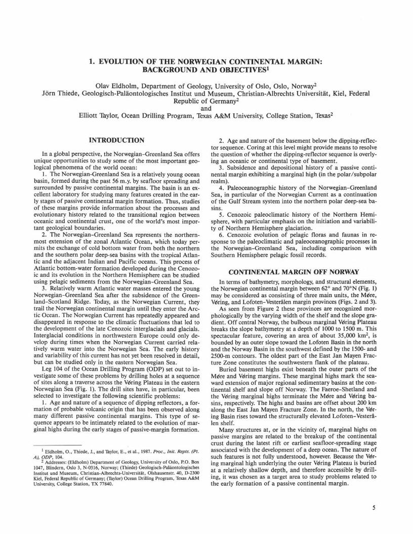
Figure 4. Simplified model of principal events in the plate-tectonic evolution of the Norwegian-Greenland Sea, based mainly on Talwani and Eldholm (1977) and Myhre et al. (1982). In three panels, anomaly number is followed by time (m.y.).
Results from multichannel seismic surveys have, however, shown complex structures at the highs and in their environs. One of the principal observations is the existence of zones of seaward-dipping reflectors beneath the sediment-basalt interface (Fig. 7). These zones exist beneath the Faeroe-Shetland and Wring basement highs and near the base of the slope in the Lofoten Basin (Hinz and Weber, 1976; Hinz and Schluter, 1978; Talwani, 1978; Eldholm et al., 1979; Talwani et al., 1981). Eldholm and Sundvor (1980) noted that the dipping reflectors always occurred landward of anomaly 23, beneath the smooth reflector earlier identified as acoustic basement. These observations have made it necessary to reexamine the idea that the escarpments form the continent/ocean boundary.
Off Norway the zone of seaward-dipping reflectors has been most thoroughly investigated in the vicinity of the Vdring Plateau Escarpment. On the basis of subsurface seismic data, Hinz et al. (1982) and Talwani et al. (1983) divided the area into the zones shown schematically in Figure 8. Zone III is underlain by
normal oceanic crust formed by seafloor spreading. Zone II, between the escarpment and the oceanic crust, consists of an outer part (Ha) characterized ay a dipping-reflector sequence below the early Eocene basalt and an inner part (lib), where the sub-basalt reflectors are horizontal or subhorizontal and rest on an underlying base reflector, K. The width of the two subzones varies along the margin. Zones Ha and lib are separated by a structural high that appears to subcrop at the level of reflector EE, thus indicating that the dipping sequence in Zone Ha is also underlain by K. Zone I marks the extent of a distinct seismic horizon believed to represent flows of the same age as the smooth volcanic reflector in Zone II. The landward limit of Zone I is also shown in Figure 3.
The series of dipping reflectors appears to be composed of individual seaward-dipping divergent beds which are slightly convex upward. In this zone, Mutter et al. (1984) found a seismic velocity distribution yielding an approximately normal oceanic layer-3 sequence, whereas the thickness of the layer-2 sequence
9
O. ELDHOLM, J. THIEDE, E. TAYLOR
63°N 10°W
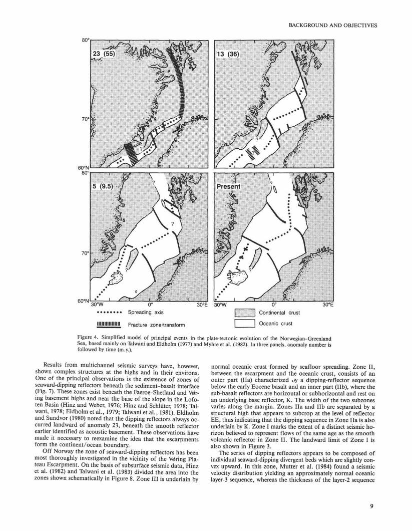
Figure 5. Early Cenozoic plate-tectonic development of the Vriring Plateau and environs, showing the magnetic anomaly pattern in the adjacent basins. Fracture Zones (FZ) and magnetic lineations (numbers) are indicated. Based on unpublished data of J. Skogseid and O. Eldholm.
10
BACKGROUND AND OBJECTIVES
70°N -
70°N
Figure 6. Early Cenozoic plate-tectonic development of the Vdring Plateau and environs. Plate reconstructions show various stages of evolution. Based on unpublished data of J. Skogseid and O. Eldholm.
is greatly expanded relative to normal oceanic crust. A possible low-velocity layer is indicated near the base of the dipping reflectors in Zone lib (Fig. 9). Finally, Mutter et al. (1984) noted that this velocity structure is similar to that of eastern Iceland.
Similar seaward-dipping sequences as well as marginal highs have been observed along many of the world's rifted passive margins (Hinz, 1981), indicating that these features may have
originated from an event that is common to their history. Their origin is not yet resolved, however. Several modes of emplacement have been suggested for the Wring Plateau dipping sequence:
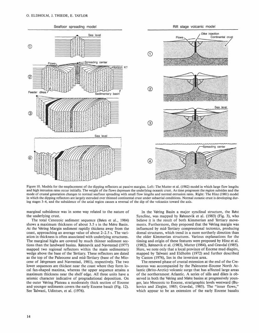
1. An Icelandic type in which generation of oceanic crust occurred subaerially during the early phase of seafloor spreading (Fig. 10). See Mutter et al. (1982).
11
O. ELDHOLM, J. THIEDE, E. TAYLOR
Site 642
Figure 7. Example of the Vetoing Plateau dipping-reflector sequence. Top: Profile BGR-1 migrated: depth section (km). Bottom: time section (STWT). Proposed Leg 104 sites are shown. Note that the location of the drilled Site 642 lies 23 shotpoints west of proposed Site V0R 1. M = middle/upper Miocene unconformity; A' = middle Oligocene; EE = top of lower Eocene basaltic flows; K = base of seaward-dipping reflector sequence. Seismic interpretation by Karl Hinz.
2. An event of intense volcanic activity during early seafloor spreading (just prior to anomaly 23 time) associated with a seaward shift of the plate boundary (Eldholm et al., 1979), overprinting the existing oceanic crust as well as the adjacent part of the continental crust.
3. Volcanic material extruded over highly thinned, contaminated continental crust in a subaerial to shallow-marine environment during the last phase of rifting (Fig. 10). See Hinz (1981).
4. Sedimentary layers filled into a half graben by a conti-nentward-dipping listric fault (Bally, 1983).
According to the first two models the continent/ocean transition lies in the vicinity of the escarpment, whereas the latter models imply a crustal boundary farther west near the seaward edge of the dipping reflectors. Mutter et al. (1982) suggest that reflector K represents the dike-lava interface, whereas Hinz et
al. (1984) suggest that it forms a Late Cretaceous surface that existed before the onset of seafloor spreading. Any models of the mode of emplacement of dipping reflectors and underlying crust must consider, however, that magnetic lineations 24A and 24B (Fig. 11) underlie parts of the dipping reflectors (Hagevang et al., 1983), and that magnetic signatures of the inner basalt flows in Zone I are absent (Eldholm et al., 1979).
Evolution of the Vriring Margin The inner part of the margin is characterized by a number of
structural elements formed before mid-Cretaceous time, whereas features relating to the Cenozoic passive-margin formation dominate the outer part (Fig. 3). The Mdre Basin, making up the main part of the Mdre margin, is a relatively unstructured basin except for the flank toward the coastline. It has been a
12
BACKGROUND AND OBJECTIVES
CD
? 3 o
:$8&$::::r' Dipping reflectors
E . „ „ n g Basin
Top Jurassic?
-X-Zone
-X-
Figure 8. Schematic geological section across the Vriring Plateau Escarpment. Zone III shows normal oceanic crust. Zone II shows sub-basalt reflections (a: dipping, b: horizontal or subhorizontal). Zone I shows inner flows (Eldholm et al., 1984).
major depocenter since Late Jurassic time, with as much as 9-10 km of post-Jurassic sediments (Hamar and Hjelle, 1984). The pre-Upper Jurassic strata are thin, reflecting uplift and erosion of a late Paleozoic depocenter during early Mesozoic time. The main phase of basin subsidence was initiated at mid-Cretaceous time (Gravdal, 1985).
The Wring (Nordland) margin consists of two main provinces separated by a structurally complex transition zone (Kris-tiansund-Bodo7 Fault Complex). To the east is a platformlike region on the central shelf bounded by the structural lineaments along the western flank of the Nordland Ridge and the outer Smrila high (Figs. 3 and 12). This area comprises the Nordland Ridge, Helgeland Basin, and Vega high. It was structured by the Kimmerian movements, but had developed as a depocenter in the late Triassic-Early Jurassic time. Except in local sub-basins, the cover of younger sediments is relatively thin. The Wring Basin to the west was formed by block faulting and rapid subsidence in Late Jurassic and Early Cretaceous times and comprises thick Upper Cretaceous sequences (Fig. 12). Remnevik et al. (1983) mapped a pre-Tertiary rift zone, the Smrila Rift, close
to the Wring Plateau escarpment. To the north the Wring Margin extends into the Traen and Vestfjord basins, the latter containing predominantly pre-Cretaceous sediments.
On the main part of the Lofoten-Vesteralen Shelf, the Ceno-zoic section is absent and the region appears to have been a positive area for long periods prior to Cenozoic time (Eldholm et al., 1979). The main shelf is underlain by a relatively thin sedimentary cover, forming a small block-faulted basin on the central shelf off Lofoten (Jrirgensen and Navrestad, 1981). A narrow Cenozoic wedge crops out just landward of the shelf edge and progrades over the lower Eocene flows, which here extend almost to the shelf edge.
In early Paleocene time the incipient margin had become part of a regionally subsiding broad basin with smoothed relief, but the southern part of the Nordland Ridge was not buried before Paleocene or early Eocene time (Jrirgensen and Navrestad, 1981). During that time, the underlying crust was gradually thinned and weakened. The process of rifting of continental crust prior to formation of a deep ocean is normally associated with up-doming, block-faulting, and subsidence prior to spreading (Bally and Snelson, 1980). A rift unconformity has been reported from many margins. On the Norwegian Margin there is little evidence of either a phase of regional crustal doming or of a rift unconformity. It appears rather that the marginal subsidence related to the initiation of seafloor spreading is in general flexural in character. Although there is clear evidence of an earlier Mesozoic rift phase, the region experienced tectonically quiet conditions lasting for about 50 m.y. in Late Cretaceous time. There are some indications, however, of Tertiary faulting on the shelf, caused most often by the reactivation of older lineaments. No evidence is seen for the typical structural pattern that would be predicted prior to the rift phase.
The mode of margin subsidence changes north of the Wring Margin. The continental slope off Lofoten-Vesteralen reveals major block faulting of the lower Eocene flows at the continental slope. Eldholm et al. (1979) noted that the new plate boundary crossed the pre-opening basin diagonally and approached the adjacent craton near Lofoten. Thus, the rifting took place at the very flank of the basin where relatively little sediment had accumulated. Eldholm et al. (1979) suggested that the mode of
km 0-
2 -
4 -
10-
12-
NW
SB300 Velocity (km/s) 3 4 5 6 7~
Outer Voting Plateau
SB331 SB283
Figure 9. Seismic velocity distribution below the lower Eocene basalt horizon at the outer Wring Plateau based on digitally recorded sonobuoys (SB) and a two-ship expanded spread profile (ESP). See Mutter et al. (1984). The stippled area denotes the region where seaward-dipping reflectors have been recognized on multichannel seismic profiles.
13
O. ELDHOLM, J. THIEDE, E. TAYLOR
Seafloor spreading model Rift stage volcanic model
Figure 10. Models for the emplacement of the dipping reflectors at passive margins. Left: The Mutter et al. (1982) model in which large flow lengths and high intrusion rates occur initially. The weight of the flows depresses the underlying oceanic crust. As time progresses the region subsides and the mode of crustal generation changes to normal seafloor spreading with small flow lengths and normal extrusion rates. Right: The Hinz (1981) model in which the dipping reflectors are largely extruded over thinned continental crust under subaerial conditions. Normal oceanic crust is developing during stages 3-4, and the subsidence of the axial region causes a reversal of the dip of the volcanics toward the axis.
marginal subsidence was in some way related to the nature of the underlying crust.
The total Cenozoic sediment sequence (Brien et al., 1984) shows a maximum thickness of about 3.5 s in the Mrire Basin. At the Wring Margin sediment rapidly thickens away from the coast, approaching an average value of about 2-2.5 s. The variation in thickness is often associated with underlying structures. The marginal highs are covered by much thinner sediment sections than the landward basins. Refnnevik and Navrestad (1977) mapped two regional reflectors within the main sedimentary wedge above the base of the Tertiary. These reflectors are dated as the top of the Paleocene and mid-Tertiary (base of the Miocene of Jdrgensen and Navrestad, 1981), respectively. The two lower sequences are thickest near the coast where they form local fan-shaped maxima, whereas the upper sequence attains a maximum thickness near the shelf edge. All three units have a seismic character indicative of progradational deposition. On the outer Wring Plateau a moderately thick section of Eocene and younger sediments covers the early Eocene basalt (Fig. 12). See Talwani, Udintsev, et al. (1976).
In the Wring Basin a major synclinal structure, the Rrist Syncline, was mapped by Remnevik et al. (1983) (Fig. 3), who believe it is the result of both Kimmerian and Tertiary movements. Furthermore, they proposed that the Wring margin was influenced by mid-Tertiary compressional tectonics, producing domal structures, which trend in a more northerly direction than the older Kimmerian structures. Various explanations for the timing and origin of these features were proposed by Hinz et al. (1982), Rrfnnevik et al. (1983), Mutter (1984), and Gravdal (1985). Here, we note only that a local province of Eocene mud diapirs, mapped by Talwani and Eldholm (1972) and further described by Caston (1976), lies in the inversion area.
The renewed phase of crustal extension at the end of the Cretaceous was accompanied by the Paleocene-Eocene North Atlantic (Brito-Arctic) volcanic surge that has affected large areas of the northernmost Atlantic. A series of sills and dikes is observed in both the Wring and Mrire basins at progressively younger, late Mesozoic to Eocene, stratigraphic levels westward (Bu-kovics and Ziegler, 1985; Gravdal, 1985). The "inner flows," which appear to be an extension of the early Eocene basalts
14
Figure 11. Magnetic anomaly pattern at the outer Wring Plateau and Lofoten Basin (Hagevang et al., 1983).
Figure 12. Interpreted seismic section across the Wring margin, showing the main geological provinces and structural elements (Skogseid, 1983).
BACKGROUND AND OBJECTIVES
drilled at the outer Vdring Plateau, are observed along the entire margin (Fig. 3). There may be a relationship between the emplacement of these flows and an event of widespread volcanic activity in the North Sea dated at 52.5-55 m.y. (Jacque and Thouvenin, 1975).
CENOZOIC PALEOENVIRONMENTS OF THE NORWEGIAN-GREENLAND SEA
Investigation of the Cenozoic paleoenvironment of the Norwegian-Greenland Sea, which developed after the ocean basin opened in late Paleocene time, is one of the aims of the transect of drill sites across the Vriring Plateau. The transect crosses the Norwegian Current in an area where the current is relatively narrow and well defined (Fig. 1). Steep hydrologic gradients separate the Norwegian Current water masses from the polar water masses of the open Norwegian-Greenland Sea and the Norwegian Coastal Current in the area of this transect. It is known from satellite- and ship-based observations that the water-mass boundaries show rapid seasonal fluctuations, often complicated by the presence of gyres. A detailed understanding of the nature and temporal changes of the Vriring Plateau Cenozoic paleoenvironment is believed to be important because of several unique features in the oceanographic history of this polar to subpolar deep-sea basin (Vogt et al., 1981).
The Norwegian-Greenland Sea and the Arctic Ocean are parts of a contiguous deep-sea basin reaching from the Antarctic to the Arctic regions. It is transected by one major sill area, the Greenland-Scotland Ridge (Bott et al., 1983) at the southern end of the Norwegian-Greenland Sea. Presently, the Norwegian-Greenland Sea provides pathways for climatically important elements of the oceanic surface-water current regimes (Fig. 13). These pathways control the advection of relatively warm water masses from the North Atlantic to the Arctic region (Norwegian Current along the Norwegian continental margin). The warm-water masses are balanced by a cold and partly ice-covered current along the East Greenland continental margin (East Greenland Current). The asymmetry of Norwegian-Greenland Sea oceanography is of great importance for the northwestern European climate, which would be fully "glacial" to "periglacial" in the absence of this relatively warm current.
Today the surface water in the Greenland Sea is cold and dense, and the area is characterized by downwelling, renewing rapidly the bottom water in the Norwegian-Greenland Sea and the Eurasian-Arctic Basin. At present, Arctic Bottom Water fills this entire deep-sea basin; it overflows the Greenland-Scotland Ridge to enter the Atlantic (Meincke, 1983), from where it can be traced into the Indian and Pacific oceans. Thus, the properties of these bottom waters have an impact on the hydrography of a large part of the water column of the world ocean.
This scenario, however, has a relatively short geological history that developed in response to both the plate-tectonic processes forming the Norwegian-Greenland Sea and the evolution of the Northern Hemisphere Cenozoic paleoclimate. The origin and evolution of the Norwegian-Greenland Sea by seafloor spreading, forming several deep-sea basins, are well known (Tal-wani and Eldholm, 1977), and reasonable assumptions about changes in size and shape of the deep-sea basins during the Cenozoic can be made (Eldholm and Thiede, 1980). However, the width, depth, and precise opening time of the deep-water passages into the adjacent ocean basins have not been determined with sufficient accuracy. Width, location, and paleodepth of the straits across the Greenland-Scotland Ridge are disputed (Thiede and Eldholm, 1983), but seem to have had modest influence until Miocene, possibly even Pliocene, time. The passage between the Greenland Sea and the Eurasian Basin (Fram Strait) started opening only after anomaly 13 time, but deep-water exchange with the Arctic Ocean might have intensified even later (Kristof-
fersen, in press) owing to the construction of the aseismic volcanic marginal Yermak Plateau and Morris Jessup Rise.
The subsequent discussion of relevant aspects of the Norwegian-Greenland Sea paleoenvironments is subdivided into a Tertiary and a Quaternary section. The evidence that is available for this discussion comes mostly from locations crowded into the ice-free part of the Norwegian Sea (Thiede, Diesen, et al., 1986). The nature of the sediment cover and depositional environment over vast areas, mainly in the Greenland Sea, remains virtually unknown because of the ice cover. Much new sample material will have to be collected over the years to document conclusively the paleoceanography of this region.
Tertiary Paleoenvironments Evidence for Norwegian-Greenland Sea Tertiary paleoenvi
ronments comes mostly from deep-sea drilling (Talwani, Udint-sev, et al., 1976), although sediment cores with pre-Quaternary pelagic deposits have been collected occasionally (Bjrirklund and Kellogg, 1972). The oldest sediments sampled during DSDP Leg 38 are of early Eocene age (Schrader et al., 1976), documenting fully pelagic and relatively warm environments during that time. It is difficult to imagine that the once high (mostly subaerial) Greenland-Scotland Ridge (Thiede and Eldholm, 1983) did not have an important impact on the water exchange between the main North Atlantic Ocean and the Norwegian-Greenland Sea. However, the apparent fully marine pelagic fossil assemblages do not seem to have been affected by this sill (Berggren and Schnitker, 1983), suggesting that it was discontinuous (possibly interrupted by the Faeroe-Shetland Channel as early as Paleo-gene time).
Reconstruction of Tertiary sediment source regions based on patterns of sedimentation rates (Thiede, et al., 1986) reveals that the dominant share of the Paleogene, possibly also lowermost Neogene, deposits were delivered from few and regionally very limited source regions on the adjacent shelves (Fig. 14). The most important area lies east of the Senja Fracture Zone in the emerged Barents Sea (Eldholm et al., 1984). Extraordinarily high sedimentation rates in areas which are today north of Iceland and in the Denmark Strait, originated at least partly from source regions along the East Greenland continental margin, where thick lower Tertiary sediment sections have been found (Larsen, 1983).
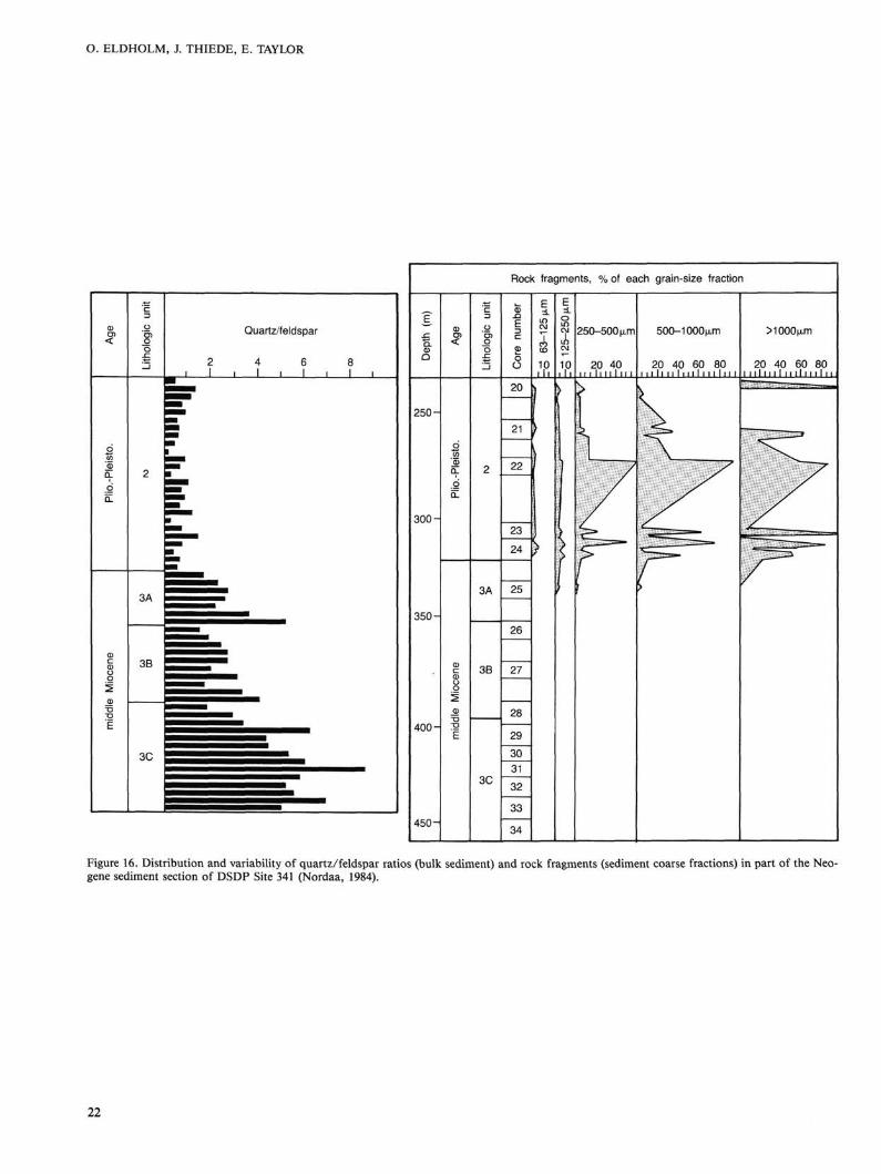
The mid-Tertiary Norwegian-Greenland Sea depositional environments are poorly known because of the development of an important, lower Neogene hiatus (Schrader et al., 1976) that separates "pre-glacial" from "glacial"-type deposits. Incomplete data for this interval, however, were obtained from DSDP Site 341 (Nordaa, 1984; Smalley et al., 1986) at the Wring Plateau (Figs. 15 and 16). Here, a major change in the proportion of quartz, rock fragments, and quartz/feldspar ratios was found in the upper Miocene-Pliocene deposits. The onset of glacially influenced sedimentation south of the Greenland-Scotland Ridge has been dated to 2.3-2.4 m.y. (Shackleton, Backman, et al., 1984). However, it is known from DSDP Site 344 (Schrader et al., 1976) and central Arctic cores (Clark et al., 1980; Thiede et al., in press) that glacial-type depositional environments in the Northern Hemisphere evolved as early as late Miocene-early Pliocene time.
Quaternary Paleoenvironments With the onset of glacial-type depositional environments in
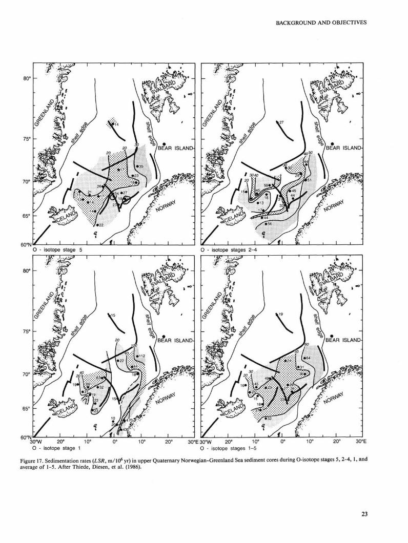
the Norwegian-Greenland Sea, the regional patterns of sediment flux to the deep-sea floors changed considerably. Isopachs of sediment with ice-rafted, coarse terrigenous components (Warnke and Hansen, 1977; Warnke, 1982) and isopleths of Quaternary sedimentation rates (Fig. 17) seem to trail the eastern continental margin, having been controlled by the major patterns of sur-
17
O. ELDHOLM, J. THIEDE, E. TAYLOR
NORWAY
30°E
Figure 13. Present-day surface-current patterns in the Norwegian-Greenland Sea (Kellogg, 1975, 1976). Heavy black bar marks approximate position of Leg 104 paleoenvironment transect.
face-water circulation. This applies to glacial as well as to inter-glacial time slices.
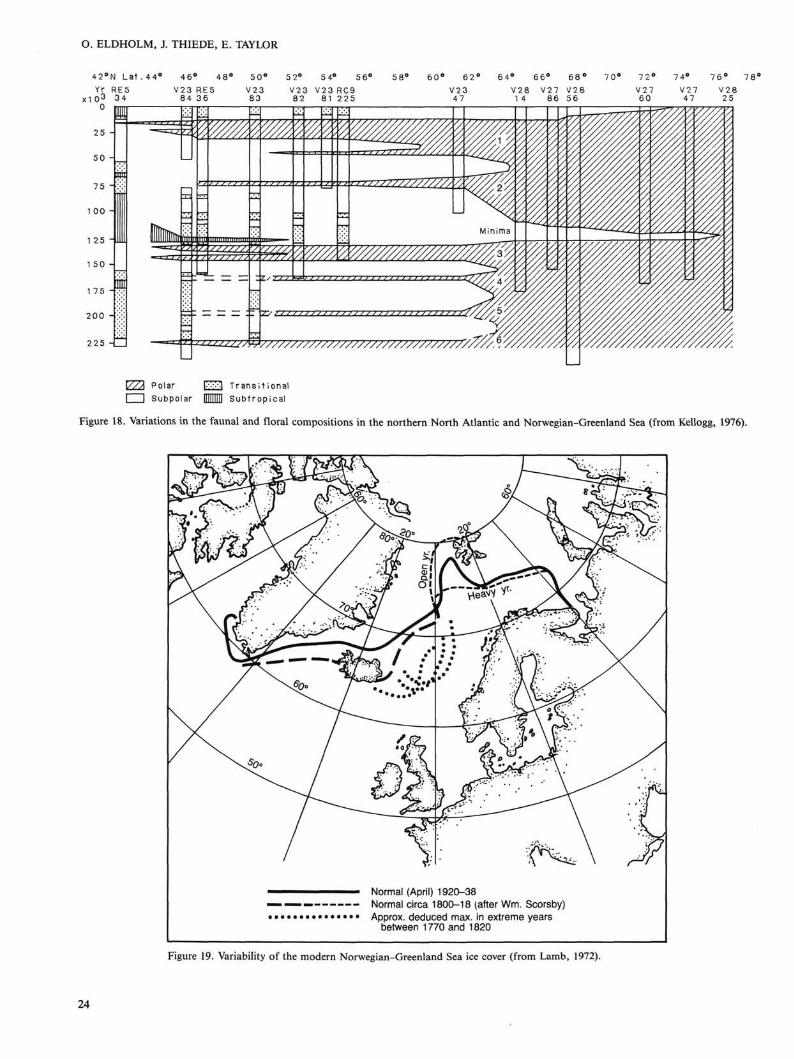
The Norwegian-Greenland Sea depositional environment has also responded intensively to the glacial-interglacial paleoclimatic fluctuations in the Quaternary. This area of the world ocean has experienced the fastest and the most drastic oceanographic changes in response to climatic variability (CLIMAP, 1976). These changes apply to parameters that have been generated in the surface waters (Fig. 18) as well as those from the bottom waters. Detailed stratigraphic studies (Kellogg, 1975, 1976; Bjrirklund and Goll, 1979) show that a relatively warm Norwegian Current reached the Norwegian Sea only during few and selected peak interglacials, such as part of O-Isotope stage 5e. Generally, the Norwegian Sea surface waters remained polar or even ice covered for most of the Quaternary. The nature, variability, and completeness of these ice covers remain poorly known, but the
presence of late glacial iceberg plow marks along the Norwegian continental shelf suggests that the surface waters were covered by pack ice mixed with icebergs, at least during times of ice-shield breakup.
The history of bottom-water properties and bottom-water formation is still the subject of much discussion (Jansen and Erlen-keuser, 1985). O- and C-stable isotope data from outer Norwegian continental-margin sediment cores (Sejrup et al., 1984) suggest that the glacial bottom water prior to Termination IA in the deep Norwegian Sea was slightly warmer than today, but lower in oxygen. Between Termination IA (13,000 years ago) and IB (10,000 years ago) a seasonal ice cover is thought to have existed during which time oxygen-enriched waters filled the deep basin. After Termination IB a situation analogous to the present may have been established. The two-tier, step wise transition from the last glacial maximum to the Holocene (Jansen et al., 1983) has
18
BACKGROUND AND OBJECTIVES
60°N 30°W 30°E
Figure 14. Distribution of linear sedimentation rates (LSR) in the Norwegian-Greenland Sea. The rates (expressed in m/106 yr) have been calculated by dividing sediment thicknesses by age of basement. The values within a grid of sample points at each 1° intersection of longitude and latitude have been used for contouring (Thiede, Diesen, et al., 1986).
also been observed in the region west of the Norway Basin, but the Greenland Sea Quaternary depositional environments seem to require further refinement through future studies.
Sedimentary data suggest rather stable Holocene conditions in the Norwegian-Greenland Sea. However, historical reconstructions based on proxy data (Fig. 19) suggest that this deep-sea area has reacted in a highly sensitive way to the minor climatic fluctuations of the youngest geologic past. Historic pack-ice margins have been reported to have extended almost to the Faeroe Islands and into the eastern parts of the Norwegian Sea, thus documenting a highly unstable oceanographic situation.
Vdring Plateau Paleoenvironments The Wring Plateau area is well suited for studying the histo
ry of depositional environments of surface-water current systems as well as of bottom water. As a marginal plateau it is elevated above the adjacent abyssal basins and is therefore expected to accumulate pelagic and hemipelagic sediment sequences not interrupted by turbidites. However, parts of the Norwegian
continental margin are known to have experienced numerous slides which might have generated hiatuses and slide deposits. The drill sites of DSDP Leg 38 in the Wring Plateau area have documented the presence of slides (Talwani, Udintsev, et al., 1976). During the selection of the ODP Leg 104 sites an effort was made to avoid disturbed regions. The placing of drill sites across the Wring Plateau is also expected to provide enough lateral spacing to establish the horizontal gradients between different surface-water masses and the vertical gradients between different layers of the water column, which once filled the Norwegian-Greenland Sea.
During DSDP Leg 38 (Talwani, Udintsev, et al., 1976), several holes were drilled at the Wring Plateau (Sites 338-343, Figs. 2 and 3). The information on the sequence of Tertiary and Quaternary sediments, however, is incomplete or poorly suited for detailed paleoceanographic studies. None of the sites was cored continuously, and only cores obtained through simple drill-pipe advance or rotary coring have been collected; hence much of the stratigraphic detail needed for modern paleoceanograph-
Figure 15. Interpreted seismic-reflection profile across the Vriring Plateau, showing locations of DSDP Sites 338 through 343 (Talwani, Udintsev, et al., 1976) and stratigraphic sections (Nordaa, 1984).
ic reconstructions has been lost. Sedimentation and accumulation rates of the bulk sediments at D S D P Site 338 have been calculated (Fig. 20) to illustrate the depositional history of the W r ing Plateau pelagic deposits (Thiede, Diesen, et al . , 1986). It is clear that the history of sediment accumulat ion on the W r i n g Plateau is highly variable, with intervals of high accumulation rates alternating with times of very low sediment fluxes. The upper par t of the Miocene and most of the Pliocene are missing completely because of the presence of a hiatus covering a 10-m.y.-long interval. The Leg 38 site positions were in areas which have been subject to current or slide erosion and only limited stratigraphic and paleoceanographic evidence can be deduced from the recovered sediments.
REFERENCES Bally, A. W., 1983. Seismic expression of structural styles. AAPG Stud.
Geol., 15:2. Bally, A. W., and Snelson, S., 1980. Facts and principles of world petro
Berggren, W. A., and Schnitker, D., 1983. Cenozoic marine environments in the North Atlantic and Norwegian-Greenland Sea. In Bott, M. H. P., Saxov, S., Talwani, M., and Thiede, J. (Eds.), Structure and Development of the Greenland-Scotland Ridge—new methods and concepts: New York (Plenum Press), 495-548.
Bjrirklund, K. R., and Goll, R. M., 1979. Ice age climates of the Norwegian-Greenland Sea. GeoJournal, 3:273-283.
Bjrirklund, K. R., and Kellogg, D. E., 1972. Five new radiolarian species from the Norwegian Sea. Micropaleontology, 18:386-396.
Beten, F., Eggen, S., and Vollset, J., 1984, Structures and basins of the margin from 62-69°N and their development. In Spencer, A. M., et
al. (Eds.), Petroleum Geology of the North European Margin: London (Graham and Trotman), 3-28.
Bott, M. H. P., Saxov, S., Talwani, M., and Thiede, J., 1983. Structure and Development of the Greenland-Scotland Ridge—new methods and concepts: New York (Plenum Press).
Bukovics, C., and Ziegler, P. A., 1985. Tectonic development of the Mid-Norway continental margin. Mar. Pet. Geol., 2:2-22.
Caston, V. N. D., 1976. Tertiary sediments of the Wring Plateau, Norwegian Sea, recovered by Leg 38 of the Deep Sea Drilling Project. In Talwani, M., Udintsev, G., et al., Init. Repts. DSDP, 38: Washington (U.S. Govt. Printing Office), 761-782.
Clark, D. L., Whitman, R. R., Morgan, K. A., and Mackey, S. D., 1980. Stratigraphy and glacial marine sediments of the Amerasian Basin, central Arctic ocean. Geol. Soc. Am. Spec. Pap., 181.
CLIMAP Project Members, 1976. The surface of the ice-age earth. Science, 191:1131-1137.
Eldholm, O., and Sundvor, E., 1980. The continental margins of the Norwegian-Greenland Sea: recent results and outstanding problems. Phil. Trans. R. Soc. Lond., A294:77-86.
Eldholm, O., Sundvor, E., and Myhre, A. M., 1979. Continental margin off Lofoten-Vesteralen, northern Norway. Mar. Geophys. Res., 4:3-35.
Eldholm, O., Sundvor, E., Myhre, A. M., and Faleide, J. I., 1984. Cenozoic evolution of the continental margin off Norway and western Svalbard. North European Margin Symp. Proc. Norw. Pet. Soc: London (Graham and Trotman), 3-18.
Eldholm, O., and Thiede, J., 1980. Cenozoic continental separation between Europe and Greenland. Palaeogeogr., Palaeoclimatol., Palae-oecol, 30:243-259.
Eldholm, O., and Windisch, C. C , 1974. Sediment distribution in the Norwegian-Greenland Sea. Geol. Soc. Am. Bull., 85:1661-1676.
Gravdal, N., 1985. The Mdre Basin, [Cand. Scient. thesis], University of Oslo, Norway.
20
BACKGROUND AND OBJECTIVES
Hagevang, T., Eldholm, O., and Aalstad, I., 1983. Pre-23 magnetic anomalies between Jan Mayen and Greenland-Senja Fracture Zones in the Norwegian Sea. Mar. Geophys. Res., 5:345-363.
Hamar, G. P., and Hjelle, K., 1984. Tectonic framework of the More Basin and the northern North Sea. In Spencer, A. M., et al. (Eds.). Petroleum Geology of the North European Margin: London (Graham and Trotman), 349-358.
Hinz, K., 1981. A hypothesis on terrestrial catastrophes: Wedges of very thick oceanward dipping layers beneath passive margins—their origin and paleoenvironmental significance. Geol. Jahrb., E22:3-28.
Hinz, K., Dostman, H. J., and Hanisch, J., 1982. Structural Framework of the Norwegian Sea. Norwegian Petroleum Society, ONS-82.
, 1984. Structural elements of the Norwegian Sea Continental Margin Geol. Jahrb., A75:193-211.
Hinz, K., and Schluter, H.-U., 1978. The geological structure of the western Barents Sea. Mar. Geology, 26:199-230.
Hinz, K., and Weber, J., 1976. Zum geologischen Aufbau des Norwegis-chen Kontinentalrandes und der Barents-See nach reflexionsseismis-chen Messungen. Erdol Kohle, Erdgas, Petrochem.. 3-29.
Jacque, M., and Thouvenin, J., 1975. Lower Tertiary tuffs and volcanic activity in the North Sea. In Woodland, A. W. (Ed.), Petroleum and the Continental Shelf of North-west Europe (Vol. 1): London (Applied Science Publishers), 455-465.
Jansen, E., and Erlenkeuser, H., 1985. Ocean circulation in the Norwegian Sea during the last deglaciation: Isotopic evidence. Palaeogeogr., Palaeoclimatol., Palaeoecol., 49:189-206.
Jansen, E., Sejrup, H. P., Fjaeran, T., Hald, M., Holtedahl, H., and Skarbd, O., 1983. Late Weichselian paleoceanography of the southeastern Norwegian Sea. Norsk Geol. Tidsskr., 63:117-146.
Jdrgensen, E , and Navrestad, T., 1981. The geology of the Norwegian Shelf between 62°N and the Lofoten Islands. In Illing, L. V , and Hobson, G. D. (Eds.), Petroleum Geology of the Continental Shelf of NW Europe: London (Institute of Petroleum), 407-413.
Kellogg, T. B., 1975. Late Quaternary climatic changes in the Norwegian and Greenland Seas. In Weller, G., and Bowling, J. A., (Eds.), Climate of the Arctic. Proc. 24th Alaska Sci. Conf., Geophys. Inst. Univ. Alaska, 3-36.
, 1976. Late Quaternary climatic changes: Evidence from deep-sea cores of Norwegian and Greenland Seas. Geol. Soc. Am. Mem., 145:77-110.
Kristoffersen, Y., 1985. The Arctic ocean: Outline of the submarine geology and geologic evolution of a polar region. Geofys. Publ. Det Norske Vitenskapsakademi, Oslo.
Kristoffersen, Y., and Talwani, M., 1977. Extinct triple junction south of Greenland and the Tertiary motion of Greenland relative to North America. Geol. Soc. Am. Bull, 88:1037-1049.
Lamb, H. H., 1972. Climate: present, past and future. Vol. 1. Fundamentals and climate now: London (Methuen & Co. Ltd.).
Larsen, B., 1983. Geology of the Greenland-Scotland Ridge in the Denmark Strait. In Bott, M. H. P., Saxov, S., Talwani, M., and Thiede, J. (Eds.), Structure and development of the Greenland-Scotland Ridge—new methods and concepts: New York (Plenum Press), 425-444.
Meincke, J., 1983. The modern current regime across the Greenland-Scotland Ridge. In Bott, M. H. P., Saxov, S., Talwani, M., and Thiede, J. (Eds.), Structure and Development of the Greenland-Scotland Ridge—new methods and concepts: New York (Plenum Press), 637-650.
Mutter, J. C , 1984. Cenozoic and late Mesozoic stratigraphy and subsidence history of the Norwegian margin. Geol. Soc. Am. Bull., 95: 1135-1149.
Mutter, J. C , Talwani, M., and Stoffa, P. L., 1982. Origin of seaward-dipping reflectors in oceanic crust off the Norwegian margin by "sub-aerial sea-floor spreading." Geology, 10:353-357.
, 1984. Evidence for a thick oceanic crust adjacent to the Norwegian margin. J. Geophys. Res., 89:483-502.
Myhre, A. M., Eldholm, O., and Sundvor, E., 1982. The margin between Senja and Spitsbergen Fracture Zones: implications from plate tectonics. Tectonophysics, 89:33-50.
Nordaa, A., 1984. Neogen Stratigrafi og sedimentasionsmiljd fra DSDP hull 341 Vriring plataet, Norkehavet (Cand. Scient. thesis). University of Oslo, Norway.
Nunns, A. G., and Peacock, J. H., 1982. Correlation, identification and inversion of magnetic anomalies in the Norway Basin. Earth Evol. Sen 2:130-138.
Rdnnevik, H., and Navrestad, T , 1977. Geology of the Norwegian shelf between 62°N and 69°N. GeoJournal, 1:33-46.
Remnevik, H. C , Eggen, S., and Vollset, J., 1983. Exploration of the Norwegian shelf. Petroleum Geochemistry and Exploration of Europe: Oxford (Blackwell Scientific Press), 71-94.
Schrader, H.-J., Bjdrklund, K. R., Manum, S., Martini, E., and van Hinte, J., 1976. Cenozoic biostratigraphy, physical stratigraphy and paleoceanography in the Norwegian-Greenland Sea, DSDP Leg 38 paleontological synthesis. In Talwani, M., Udintsev, G., et al., Init. Repts. DSDP, 38: Washington (U.S. Govt. Printing Office), 1197-1211.
Sejrup, H. P., Jansen, E., Erlenkeuser, H., and Holtedahl, H., 1984. New faunal and isotopic evidence on the Late Weichselian-Holocene oceanographic changes in the Norwegian Sea. Quatern. Res., 7: 74-84.
Shackleton, N. J., and Opdyke, N. D., 1976. Oxygen-isotope and pa-leomagnetic stratigraphy of Pacific core V28-239, late Pliocene to latest Pleistocene. Mem. Geol. Soc. Am., 145:449-464.
Shackleton, N. J., Backman, J., et al., 1984. Oxygen isotopic calibration of the onset of ice-rafting and the history of glaciation in the North Atlantic region. Nature, 307:620-623.
Skogseid, J., 1983. A marine geophysical study of profiles between the Vriring Plateau margin and the Jan Mayen Ridge. [Cand. Scient. thesis], University of Oslo, Norway.
Smalley, P. C , Nordaa, A., and Raheim, A., 1986. Geochronology and paleothermometry of Neogene sediments from the VeJring Plateau using Sr, C and O isotopes. Earth Planet. Sci. Lett., 78:368-378.
Srivastava, S. P., 1978. Evolution of the Labrador Sea and its bearing on the early evolution of the North Atlantic. Geophys. J. R. Astron. Soc, 52:313-357.
Talwani, M., 1978. Distribution of basement under the eastern North Atlantic Ocean and the Norwegian Sea. Geol. J. Spec. Iss., 5: 347-376.
Talwani, M., and Eldholm, O., 1972. The continental margin off Norway: A geophysical study. Geol. Soc. Am. Bull., 83:3375-3608.
, 1973. The boundary between continental and oceanic crust at the margin of rifted continents. Nature, 241:325-330.
, 1977. Evolution of the Norwegian-Greenland Sea: recent results and outstanding problems. Geol. Soc. Am. Bull., 88:969-999.
Talwani, M., and Udintsev, G., 1976. Tectonic synthesis. In Talwani, M., Udintsev, G., et al., Init. Repts. DSDP, 38: Washington (U.S. Govt. Printing Office), 1213-1242.
Talwani, M., and Udintsev, G., et al., 1976. Init. Repts. DSDP, 38: Washington (U.S. Govt. Printing Office).
Talwani, M., Mutter, J., and Eldholm, O., 1981. The initiation of opening of the Norwegian Sea. Oceanologica Acta, No. SP:23-30.
Talwani, M., Mutter, J., Hinz, K., 1983. Ocean continent boundary under the Norwegian continental margin. In Bott, M. H. P., Saxov, S., Talwani, M., and Thiede, J. (Eds.), Structure and Development of the Greenland-Scotland Ridge—new methods and concepts: New York (Plenum Press), 121-131.
Thiede, J., and Eldholm, O., 1983. Speculations about the paleodepth of the Greenland-Scotland Ridge during Late Mesozoic and Cenozoic times. In Bott, M. H. P., Saxov, S., Talwani, M., and Thiede, J. (Eds.), Structure and Development of the Greenland-Scotland Ridge—new methods and concepts: New York (Plenum Press), 445-456.
Thiede, J., Diesen, G. W , Knudsen, B. E., and Snaare, T. W , 1986. Patterns of Cenozoic sedimentation in the Norwegian-Greenland Sea. Mar. Geol., 69:323-352.
Thiede, J., Clark, D. L., and Herman, Y, (in press). Late Mesozoic and Cenozoic paleoceanography of northern polar oceans. In Grantz, A., Johnson, L., and Sweeney, J. F. (Eds.), The Arctic Region. Geol. Soc. Am. DNAG.
Vogt, P. R., Perry, R. K., Feden, R. H., Fleming, H. S., and Cherkis, N. Z., 1981. The Greenland-Norwegian Sea and Iceland environment: Geology and geophysics. In Nairn, A. E. M., Churkin, M., and Stehli, F. G., (Eds.), The Ocean Basins and Margins. Vol. 5. The Arctic Ocean: New York (Plenum Press), 493-598.
Warnke, D. A., 1982. Pre-middle Pliocene sediments of glacial and peri-glacial origin in the Norwegian-Greenland Sea: Results of DSDP Leg 38. Earth Evolution Sciences 2:69-78.
Warnke, D. A., and Hansen, M. E., 1977. Sediments of glacial origin in the area of operations D.S.D.P. Leg 38 (Norwegian-Greenland Seas): Preliminary results from Sites 336-344. Ber. Naturforsch. Ges. Freiburg iBr., 67:371-392.
21
O. ELDHOLM, J. THIEDE, E. TAYLOR
Age
Plio
.-Ple
isto
. m
iddl
e M
ioce
ne
Lith
olog
ic u
nit
2
3A
3B
3C
Quartz/feldspar
2 4 6 8 i 1 i 1 i 1 i 1 i illllilh
.ll.lllll.lll.il
Figure 16. Distribution and variability of quartz/feldspar ratios (bulk sediment) and rock fragments (sediment coarse fractions) in part of the Neo-gene sediment section of DSDP Site 341 (Nordaa, 1984).
Figure 17. Sedimentation rates (LSR, m/106 yr) in upper Quaternary Norwegian-Greenland Sea sediment cores during O-isotope stages 5, 2-4, 1, and average of 1-5. After Thiede, Diesen, et al. (1986).
23
O. ELDHOLM, J. THIEDE, E. TAYLOR
42°N L a t . 4 4 ° 46° 48° 50° 5 2° 5 4° 56° 58° 60° 62° 64° 66 76° 78*
V/A Polar l-x^l Transi t ional I I Subpolar HMD Subtropical
Figure 18. Variations in the faunal and floral compositions in the northern North Atlantic and Norwegian-Greenland Sea (from Kellogg, 1976).
Figure 19. Variability of the modern Norwegian-Greenland Sea ice cover (from Lamb, 1972).
24
BACKGROUND AND OBJECTIVES
15 20 25 30 35 40
LSR in m/106yr BAR in 102g cm"2/103yr
Figure 20. Bulk accumulation and linear sedimentation rates (BAR and LSR, respectively) at DSDP Site 338 on the Wring Plateau (from Thiede, Diesen, et al., 1986).