9 1. Forests of the Congo Basin Overview F ollowing the Amazonian forests, the forests of the Congo Basin constitute the second larg- est area of dense tropical rainforest in the world. ey stretch from the coast of the Gulf of Guinea in the west to the mountains of the Albertine Rift in the east 1 and cover about seven degrees of latitude on either side of the equator. ey are mostly within the Guinea-Congo forest structure, of which they constitute over 80% of the total area. In the west of Cameroon and the east of the Democratic Republic of Congo, they also include the Afromontane forests. is report focuses on the forests of the countries forming part of the CBFP partnership - Cameroon, Equatorial Guinea, Gabon, the Central African Republic (CAR), the Republic of Congo and the Democratic Republic of Congo (DRC). e area of these forests nears 200 mil- lion hectares (Figure 1.1); however estimates of their area vary considerably. Certain estimates are at the least surprising 2 , but even the weakest esti- mates vary depending on what one considers to be forests. According to the FAO, which uses a wide definition, the area of the forests was 227.61 million hectares in 2005. According to MODIS and GLC2000 maps, the area was 180.46 million hectares in 2000 (page 82). Relief and altitude Unlike the tropical forests of Southeast Asia or West Africa, but similar to those of Amazonia, the forests of Central Africa still form a vast and more or less continuous block. However, whereas the Amazonian forests are largely situated just above sea level, 80% of the forests of Central Africa are located between 300 and 1000 m of al- titude (Figure 1.2). Only the forests in the coastal sedimentary basin, which represent 7% of the to- tal area of the forests and are located mainly in Cameroon and Gabon, are at a height of less than 300m (page 82). e submontane forests, at an altitude of between 1,000 and 1,600 m, cover 2.8% of the forest area and the montane forests, above 1,600 m, cover only 0.8% of the area. ese forests are spread over two fragmented blocks separated by over 2,000 km. Comparable forests in South America form an almost uninterrupted strip all along the Andes Chain. Forests showing clear submontane influences cling to the mid-altitude features (650-1,200 m) which run parallel to the gulf coast of Guinea 100-200 km inland and capture the Atlantic clouds, especially in the dry season. Along with continual climatic variations that have affected and continue to affect Central Africa, this spatial configuration of the forests has played an important role in the evolution of its flora and fauna 3 . Climate Precipitation is the main factor determining vegetation in a tropical environment. Overall, pre- cipitation varies between 1,600 and 2,000 mm a year on average. However, three areas with notice- ably higher rainfall can be identified: the eastern edge and the center of the Congo Basin, with pre- cipitation of around 2,000 to 2,500 mm per year on average, and the coastal area from Libreville in Gabon to the foot of Mount Cameroon, with pre- cipitation averaging 3,000 to 11,000 mm a year (Figure 1.3). 1 e forest relics of western Uganda and Kenya are also part of the Guinea- Congo forest structure. 2 e State of Africa 2006 suggests a total area of 520 million hectares (Maury, 2006). 3 With changes in climate, species in the Andean forests have shifted both in an altitudinal and north-south direction, while African species have only shifted in an altitudinal direction. Even the Albertine Rift is not extensive enough for significant latitudinal shifts to appear. Figure 1.3. Precipitation in Cenral Africa (Sources : ESRI, Worldclim data, University of California, Berkeley, USA). Figure 1.2. Relative abundance of the principal types of vegetation (Source: JRC).
Transcript
9
1. Forests of the Congo BasinOverview
Following the Amazonian forests, the forests of the Congo Basin constitute the second larg-
est area of dense tropical rainforest in the world. Th ey stretch from the coast of the Gulf of Guinea in the west to the mountains of the Albertine Rift in the east1 and cover about seven degrees of latitude on either side of the equator. Th ey are mostly within the Guinea-Congo forest structure, of which they constitute over 80% of the total area. In the west of Cameroon and the east of the Democratic Republic of Congo, they also include the Afromontane forests.
Th is report focuses on the forests of the countries forming part of the CBFP partnership - Cameroon, Equatorial Guinea, Gabon, the Central African Republic (CAR), the Republic of Congo and the Democratic Republic of Congo (DRC). Th e area of these forests nears 200 mil-lion hectares (Figure 1.1); however estimates of their area vary considerably. Certain estimates are at the least surprising2, but even the weakest esti-mates vary depending on what one considers to be forests. According to the FAO, which uses a wide defi nition, the area of the forests was 227.61 million hectares in 2005. According to MODIS and GLC2000 maps, the area was 180.46 million hectares in 2000 (page 82).
Relief and altitude
Unlike the tropical forests of Southeast Asia or West Africa, but similar to those of Amazonia, the forests of Central Africa still form a vast and more or less continuous block. However, whereas the Amazonian forests are largely situated just above sea level, 80% of the forests of Central
Africa are located between 300 and 1000 m of al-titude (Figure 1.2). Only the forests in the coastal sedimentary basin, which represent 7% of the to-tal area of the forests and are located mainly in Cameroon and Gabon, are at a height of less than 300m (page 82).
Th e submontane forests, at an altitude of between 1,000 and 1,600 m, cover 2.8% of the forest area and the montane forests, above 1,600 m, cover only 0.8% of the area. Th ese forests are spread over two fragmented blocks separated by over 2,000 km. Comparable forests in South America form an almost uninterrupted strip all along the Andes Chain. Forests showing clear submontane infl uences cling to the mid-altitude features (650-1,200 m) which run parallel to the gulf coast of Guinea 100-200 km inland and capture the Atlantic clouds, especially in the dry season. Along with continual climatic variations that have aff ected and continue to aff ect Central Africa, this spatial confi guration of the forests has played an important role in the evolution of its fl ora and fauna3.
Climate
Precipitation is the main factor determining vegetation in a tropical environment. Overall, pre-cipitation varies between 1,600 and 2,000 mm a year on average. However, three areas with notice-ably higher rainfall can be identifi ed: the eastern edge and the center of the Congo Basin, with pre-cipitation of around 2,000 to 2,500 mm per year on average, and the coastal area from Libreville in Gabon to the foot of Mount Cameroon, with pre-cipitation averaging 3,000 to 11,000 mm a year (Figure 1.3).
1 Th e forest relics of western Uganda and Kenya are also part of the Guinea-Congo forest structure. 2 Th e State of Africa 2006 suggests a total area of 520 million hectares (Maury, 2006).3 With changes in climate, species in the Andean forests have shifted both in an altitudinal and north-south direction, while African species have only shifted in an altitudinal direction. Even the Albertine Rift is not extensive enough for signifi cant latitudinal shifts to appear.
Figure 1.3. Precipitation in Cenral Africa (Sources : ESRI, Worldclim data, University of California, Berkeley, USA).
Figure 1.2. Relative abundance of the principal types of vegetation (Source: JRC).
10
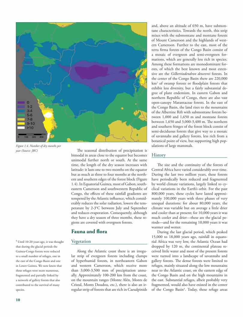
Th e seasonal distribution of precipitation is bimodal in areas close to the equator but becomes unimodal further north or south. At the same time, the length of the dry season increases with latitude: it lasts one to two months on the equator but as much as three to four months at the north-ern and southern edges of the forest block (Figure 1.4). In Equatorial Guinea, most of Gabon, south-eastern Cameroon and southwestern Republic of Congo, the eff ects of these rainfall gradients are tempered by the Atlantic infl uence, which consid-erably reduces the solar radiation, lowers the tem-perature by 2-3°C between July and September and reduces evaporation. Consequently, although they have a dry season of three months, these re-gions are covered with evergreen forests.
Fauna and fl ora
Vegetation
Along the Atlantic coast there is an irregu-lar strip of evergreen forests including clumps of hyperhumid forests, in northeastern Gabon and western Cameroon, which receive more than 3,000-3,500 mm of precipitation annu-ally. Approximately 100-200 km from the coast, on the mountain ranges (Monte Alén, Monts de Cristal, Monts Doudou, etc.), there is also an ir-regular strip of forests that are rich in Caesalpinids
and, above an altitude of 650 m, have submon-tane characteristics. Towards the north, this strip mixes with the submontane and montane forests of Mount Cameroon and the highlands of west-ern Cameroon. Further to the east, most of the terra fi rma forests of the Congo Basin consist of a mosaic of evergreen and semi-evergreen for-mations, which are generally less rich in species. Among these formations are monodominant for-ests, of which the best known and most exten-sive are the Gilbertiodendron dewevrei forests. In the center of the Congo Basin there are 220,000 km2 of swamp forests or fl oodplain forests that exhibit less diversity, but a fairly substantial de-gree of plant endemism. In eastern Gabon and northern Republic of Congo, there are also vast open-canopy Marantaceae forests. In the east of the Congo Basin, the land rises to the mountains of the Albertine Rift with submontane forests be-tween 1,000 and 1,650 m and montane forests between 1,650 and 3,000-3,400 m. Th e northern and southern fringes of the forest block consist of semi-deciduous forests that give way to a mosaic of savannahs and gallery forests, less rich from a botanical point of view, but supporting high pop-ulations of large mammals.
History
Th e size and the continuity of the forests of Central Africa have varied considerably over time. During the last two million years, these forests have periodically been reduced and fragmented by world climate variations, largely linked to cy-clical variations in the Earth’s orbit. For the past 800,000 years, these cycles have lasted approxi-mately 100,000 years with three phases of very unequal durations: for about 80,000 years, the climate was variable but on average a little drier and cooler than at present; for 10,000 years it was much cooler and drier—these are the glacial pe-riods—and for the remaining 10,000 years it was warmer and wetter.
During the last glacial period, which peaked 15,000 to 18,000 years ago, rainfall in equato-rial Africa was very low, the Atlantic Ocean had dropped by 120 m, the continental plateau re-ceived little water and most of the present forests were turned into a landscape of savannahs and gallery forests. Th e dense forests were limited to refuges, mainly situated along the low mountains near to the Atlantic coast, on the eastern edge of the Congo Basin and on the high mountains in the east. Substantial refuges, albeit probably very fragmented, would also have existed in the center of the Congo Basin4. Today, these refuge areas
4 Until 10-20 years ago, it was thought that during the glacial periods the Guinea-Congo forests were reduced to a small number of refuges, one in the east of the Congo Basin and one in Lower Guinea. We now know that these refuges were more numerous, fragmented and partially linked by a network of gallery forests that also contributed to the survival of many species.
Figure 1.4. Number of dry months per year (Source: JRC)
11
still have a higher degree of endemism and greater diversity of species relative to other areas of the Congo Basin forests.
Climatic fl uctuations are not limited to these great glaciation cycles. More localized variations, of the El Niño-La Niña type, appear depending on the distribution of the surface temperatures of the oceanic waters. Th e most recent natural re-cession of the forest formations dates back only 2,000 to 2,500 years. At that time, the forests un-derwent extreme fragmentation due to the spread of grasslands and even now they are still in the process of recolonizing areas where forests were lost. Due to this process, a large portion of the forests of Gabon are pioneer okoume (Aucoumea klaineana) forests in various stages of evolution. Okoume, a very important commercial timber species in Gabon, is one of the main species that colonizes savannahs, but it has diffi culty regener-ating in mature forests and is therefore eventu-ally replaced by other species. In many other re-gions of Central Africa (Cameroon, Republic of Congo), rapid reforestation of the savannahs can also be observed.
Th is continual succession of expansion and re-gression of the forest, combined with the changes brought about by man, mean that the overall picture of the forests in the Congo Basin is very complex. Unfortunately, the implications of these processes for forest management and the conser-vation of biodiversity are still poorly understood.
Species richness and endemism
Overall, the forests of Central Africa have fewer species than those of America or Asia. Th is can be partially explained by their smaller size and the extreme contractions that they have un-dergone during the cold, dry spells of the Tertiary and, most signifi cantly, the Quaternary periods. Nevertheless, the biodiversity of these forests is of worldwide importance because the fauna and fl ora in the forests of the Congo Basin do not exist anywhere else on earth. Th is uniqueness is found at the species and genus levels, as well as, to a lesser extent, the family level.
Th e fl ora in the low-altitude forests is com-prised of over 10,000 species of higher plants, of which 3,000 are endemic. Some families are sparse or almost absent, particularly Dipterocarpaceae, Cactaceae, Bromeliaceae and Humiriaceae, but others, such as Euphorbiaceae, Leguminaceae, Meliaceae, Sapotaceae and Moraceae, are highly diversifi ed. Nine families are endemic: Dioncophyllaceae, Huaceae, Hoplestigmataceae, Lepidobotryaceae, Medusandraceae, Octokne-
maceae, Pandaceae, Pentadiplandraceae and Scytopetalaceae (Figure 1.5). Th e fl ora of the Afromontane forests is comprised of only 4,000 species, but at least 70% of them are endemic. Th ere are two endemic families—Barbeyaceae and Oliniaceae—and also conifer species of the Podocarpus genus.
With respect to fauna, these forests house for-est forms of the African elephant and the buff alo, together with endemic species such as the okapi, the bongo (Figure 1.6), the bonobo and the goril-la. Th e Anomaluridae, most of the Cephalophinae and Colobinae and many Cercopithecidae are confi ned to these forests. Th eir avifauna includes the Congo peacock and several families endemic to Africa, notably the guineafowl (Numididae), the turacos (Musophagidae) (Figure 1.7), the puff -back and wattle-eyed fl ycatchers (Platysteiridae), the bush-shrikes (Malaconotidae) and the hel-met-shrikes (Prionopidae).
Distribution and biogeography
Th e fl ora and fauna of the Congo Basin are very unequally distributed over the forests as a whole. Th us, the specifi c richness, as well as the composition of the associations and communities, varies enormously from one region to another.
Overall two areas with particularly high spe-cies richness can be identifi ed: (1) the forests of Lower Guinea in the west (Cameroon, Equatorial Guinea, Gabon) and (2) those on the piedmont of the Albertine Rift in eastern DRC. Th ese ar-eas are separated by a vast, less rich area that cov-ers the entire central region of the Congo Basin. Th e Guinea-Congo forests comprise three bio-geographical entities of which two are in Central Africa: (1) the forests of Lower Guinea, which stretch from Nigeria to the eastern border of Gabon—this coincides with the separation of the Congo and Ogooué basins; (2) the Congolese forests, which are confi ned to the hydrographical basin of the Congo; and (3) the forests of Upper Guinea, which run from Ghana to Guinea and are separated from the other entities by the Togo and Benin savannah strip. Although the Lower Guinea and the Congolese forests are now con-tiguous, in the past they were often separated by a corridor of open countryside and swamp or fl ood-plain forests.
Recognizing that care must be taken when assessing the richness of species—it all depends on the scale on which one is working5—it would appear that the forests of Lower Guinea are the richest on the continent (Th omas, 2004). As for the relatively lower species richness of the Central
5 Th e number of species in a given zone is proportional to its area. Th e larger the area, the greater the potential for a more diverse set of habitats. One can therefore only compare zones with the same surface area.
Figure 1.5. Scytopetalum klaineanum.
Figure 1.6. Th e bongo Tragelaphus euryceros.
Figure 1.7. Th e giant turaco Corythaeola cristata.
12
Basin, it is possible that this is partly the result of insuffi cient knowledge (Figure 1.8).
Going beyond these two main biogeographi-cal entities, the distribution of species is much more complex and northeast and eastern distri-bution patterns vary from one taxonomic group to another. In the case of birds, over 90% of the species exist throughout the forest block. With mammals, on the other hand, the distribution of species is highly compartmentalized because large watercourses have proven to be insurmountable obstacles to dispersion6. In the case of plants, some species are very widely distributed while others are highly localized7. Furthermore, the relative abundance of species varies greatly from one place to another. Despite the very fl at relief, the forests of the Congo Basin are divided up into a fi ne mosaic of formations based on their domi-
nant species. Some formations contain a large number of species while others are dominated by a single species, generally a Leguminacea from the subfamily Caesalpinioidea. Th e best known are the Gilbertiodendron dewevrei forests which occur from Cameroon to eastern DRC, and which also cover very large areas on the edges of the Central Basin.
Th e biogeography of the forests of Central Africa is extremely complex. It refl ects not only the ecological requirements of the various groups of organisms and their responses to environmen-tal parameters, but also the history of the region over the last few million years.
Terrestrial ecoregions
Eff orts for the conservation and sustainable logging of the forests of Central Africa face a ma-jor problem: on the one hand, knowledge is still incomplete and for many groups of organisms we do not know exact distributions. On the other hand, the knowledge that we do have shows that the biogeography of this region is very complex. In order to simplify the situation, primarily for practical purposes, the whole area has been sub-divided into 14 ecoregions8 (Figure 1.9). Th is concept is widely used by conservation NGOs, especially WWF. However, for certain scientists this classifi cation system is unsatisfactory because the boundaries between some of the ecoregions do not correspond to the reality on the ground9. In truth, ecoregions are more of a tool for plan-ning than research.
Aquatic ecoregions
In Central Africa, the aquatic ecosystems and forest ecosystems are intimately linked, not only from the point of view of the fauna and fl ora but also through human activities and the economy. It is important to remember that the entire center of the Central Basin of the Congo River is taken up by the second largest marsh in the world, covered by various types of swamp or fl oodplain forests. From the hydrological point of view, the forests of Central Africa are drained by the Congo River
Figure 1.8. State of knowledge (Sources : ESRI, WWF-US).
6 Th is phenomenon has been clearly demonstrated for species and subspecies of primates, particularly through the work of Colyn (1987, 1991). 7 Th e work of Sosef (1994) showed that for begonias of the subgenera Loasibegonia and Scutobegonia, 21 centers of endemism are evident in Central Africa: 5 in the Congo region, 17 in Lower Guinea.8 An ecoregion is a relatively large area of land that contains an assemblage of habitats and species that is distinct from those of neighboring ecoregions.
13
Basin and a series of coastal rivers which empty into the Gulf of Guinea. Th e largest of these riv-ers are the Sanaga, Ntem, Ogooué, Nyanga, Niari and Kouilou. Th e basin of the Congo River covers an area of 3.4 to 4.1 million km2 — estimates vary — and can be subdivided into several sub-basins according to the quality of the water, the sur-rounding vegetation, the particular characteristics of the fauna and the seasonal fl ooding and reced-ing of the waters. As is the case with the terrestrial environments, insuffi cient information is avail-able on the aquatic ecoregions and vast portions of the Congo Basin have been barely explored. Th is is particularly regrettable in light of the fact that aquatic resources play an important role in the lives of the region’s inhabitants. Similar to the terrestrial ecoregions it is possible to distinguish a number of diff erent aquatic ecoregions, 16 of which lie within the forest block (Figure 1.10).
Ecological services
In addition to its species richness and endemic species, the Congo Basin also represents one of the last regions in the world where vast interconnect-ed expanses of tropical rainforest permit biologi-cal processes to continue undisturbed. It is a rare example of a place where an animal the size of the forest elephant can still act freely on its ecosystem, like an ‘engineer’ transforming the landscape by infl uencing the distribution of species and main-taining natural ecological systems. Furthermore, because of their size, the forests of the Congo Basin constitute a carbon reserve of global signifi -cance for regulating the primary greenhouse gas, carbon dioxide. Finally, these forests also help to regulate the regional and local climates. In par-ticular, they ensure that water is recycled as over 50% of the rainfall on the Congo Basin comes from local evaporation and evapotranspiration.
9 Th e Gabonese forests change very gradually and evenly from west to east. At the very most one could possibly identify a separating line between the forests of the coastal sedimentary basin and those of the inland plateaus and mountains (and this only to the north of the Ogooué), but the current dividing line between the ecoregion of the equatorial forests on the Atlantic coast and the ecoregion of the Congolese forests in the northwest is totally arbitrary. It would perhaps have been wiser to draw two or three demarcation lines: the fi rst at the edge of the coastal basin; the second (optional) at the junction of the mountain chains and the central plateau; and the third more or less at the watershed between the Congo and the Ogooué basins. On the other hand, the ecoregion of the montane forests of Itombwe only represents a subregion of the Albertine Rift region. Its fl ora and fauna are slightly richer, but overall very similar to other forests of this ecoregion. In particular, it shares several endemic species with the Nyungwe forest of Rwanda.
Approximately 30 million people, from over 150 ethnic groups, currently live in the for-
ests of Central Africa. Their presence in these forests can be dated back to different periods. Traces of human occupation from several hun-dreds of thousands of years ago have been found in multiple places within the forests1. However, it is probable that for a very long time these popu-lations lived in patches of savannah, at the edge of dense forests or along major watercourses. It remains very diffi cult to determine exactly when humans began to live in the heart of the forests. We do know that the Pygmies, who represent populations particularly well adapted to the forest environment, have existed for 20,000 to 25,000 years. The originally Neolithic and later metal-lurgist Bantu populations penetrated the forest from the northwest. In approximately 4,000 BP, they crossed the Sanaga and by 2,500 BP they occupied almost all of Lower Guinea. By around 1,000 BP, the whole forest block was colonized. In the north and the east, Ubangi and Sudanic populations intermixed with the Bantu migra-tions and infl uenced local cultures. Unlike the situation in Amazonia, the majority of the human populations still living in the Congo Basin forests are indigenous (Box 2.1).
Interrelations
For 15,000 years, the Pygmies likely repre-sented the only human populations living in the Congo forests. With the arrival of Bantu farmers, complex relations developed between the hunter-gatherers and farmers. The former were more fa-miliar with the forest, but suffered from a scarcity of carbohydrates. They started to exchange labor and forest products such as meat, fi sh or honey for items rich in carbohydrates and, more recent-ly, for manufactured products. The widely dis-persed groups found today are distinguished by their degree of nomadism and their dependence on farmers.
Traditional agriculture in African forests was based on a cycle of forest clearance, cultivation, fal-low periods and secondary reforestation followed once again by forest clearance. In the Neolithic age, the oil palm Elaeis and yams Dioscorea sp. played an essential agricultural role. Between 2,000 and 2,500 years ago, a banana from Asia was introduced and between 400 and 500 years ago plants of American origin, mainly manioc, beans, peanuts, maize and sweet potatoes, began to be cultivated.
This diversifi cation altered the agricultural landscape, transformed habits and led to an overall increase in human population. The poor fertility of the soils found in the dense rainfor-ests in Africa and the overall low productivity of tropical forests meant that the majority of the forest-dwelling populations in the Congo Basin continued to depend on the forests’ natural re-sources. Furthermore the traditional lifestyle of hunter-gatherers and farmers is sustainable only in situations characterized by low human popula-tion density — probably less than 4 inhabitants/km2 — and where the sole use of natural resources is local consumption. It was only in the high alti-tude regions of Cameroon and eastern DRC that more productive agriculture, often complimented by stock farming, was able to expand, resulting in higher human population densities.
Distribution
Human populations in the Congo Basin for-ests are very unevenly distributed (Figure 2.3). In the low-altitude regions, the largest human popu-lations are found along the forests’ edges in close proximity to adjoining savannahs. Additional populations are concentrated along the major
2.1. Indigenous populations
In Amazonia, the indigenous Amerindian population represents less than 1% of forest dwellers. Th e remaining 99% originated from Europe, Africa or Asia. Th is situation led to the development of socio-political and environmental movements which for several decades have been working to protect these native populations. Similar movements also developed in certain parts of southeast Asia and in Africa. However in Central Africa the situation is diff erent: populations originating out-side Africa represent only a tiny fraction of the total population. All forest dwellers have been living in the forest and its immediate surroundings for more than 1000 years. Despite this, the term ‘indigenous population’ is used to describe nomadic (or semi-nomadic) hunter-gatherers in Central Africa. Th e term includes certain groups of Pygmies (Figures 2.1 and 2.2) even though some Pygmies have aban-doned their hunter-gatherer livelihoods and become sedentary. Some Pygmies groups are also now mixed with Bantus, and certain Bantu groups have integrated Pygmies.
Figure 2.2. Pygmy woman from the northeast of the Democratic Republic of Congo.
Figure 2.1. Pygmy hunter in Gabon.
14
1 Near Lopé National Park in Gabon, sharpened stone tools dated at least 480,000 years have been found (Oslisly, 1994, 1998 and 2001).
2. Human Populations in the Forest
15
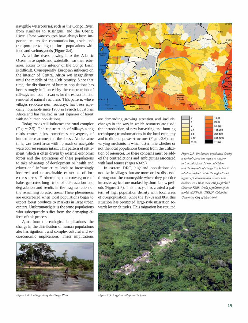
navigable watercourses, such as the Congo River, from Kinshasa to Kisangani, and the Ubangi River. These watercourses have always been im-portant routes for communication, trade and transport, providing the local populations with food and various goods (Figure 2.4).
As all the rivers fl owing into the Atlantic Ocean have rapids and waterfalls near their estu-aries, access to the interior of the Congo Basin is diffi cult. Consequently, European infl uence on the interior of Central Africa was insignifi cant until the middle of the 19th century. Since that time, the distribution of human populations has been strongly infl uenced by the construction of railways and road networks for the extraction and removal of natural resources. This pattern, where villages re-locate near roadways, has been espe-cially noticeable since 1930 in French Equatorial Africa and has resulted in vast expanses of forest with no human populations.
Today, roads still infl uence the rural complex (Figure 2.5). The construction of villages along roads creates halos, sometimes convergent, of human encroachment in the forest. At the same time, vast forest areas with no roads or navigable watercourses remain intact. This pattern of settle-ment, which is often driven by external economic forces and the aspirations of these populations to take advantage of development or health and educational infrastructure, leads to increasingly localized and unsustainable extraction of for-est resources. Furthermore, the convergence of halos generates long strips of deforestation and degradation and results in the fragmentation of the remaining forested areas. These phenomena are exacerbated when local populations begin to export forest products to markets in large urban centers. Unfortunately, it is the same populations who subsequently suffer from the damaging ef-fects of this process.
Apart from the ecological implications, the change in the distribution of human populations also has signifi cant and complex cultural and so-cioeconomic implications. These implications
are demanding growing attention and include: changes in the way in which resources are used; the introduction of new harvesting and hunting techniques; transformations in the local economy and traditional power structures (Figure 2.6); and varying mechanisms which determine whether or not the local populations benefi t from the utiliza-tion of resources. To these concerns must be add-ed the contradictions and ambiguities associated with land tenure (pages 63-69).
In eastern DRC, highland populations do not live in villages, but are more or less dispersed throughout the countryside where they practice intensive agriculture marked by short fallow peri-ods (Figure 2.7). This lifestyle has created a pat-tern of high population density with local areas of overpopulation. Since the 1970s and 80s, this situation has prompted large-scale migration to-wards lower altitudes. This migration has resulted
Figure 2.3. Th e human population density is variable from one region to another in Central Africa. In most of Gabon and the Republic of Congo it is below 2 inhabitants/km², while the high altitude regions of Cameroon and eastern DRC harbor over 150 or even 250 people/km² (Sources: ESRI, Gridd population of the worlds (GPWv3), CIESIN, Columbia University, City of New York).
Figure 2.4. A village along the Congo River. Figure 2.5. A typical village in the forest.
in confl icts between resident populations and im-migrants, mainly due to the fact that the social habits and agricultural methods of the latter are different from those of the resident populations and may be poorly suited to the new conditions.
Current Situation
Traditional cultures in Central Africa have been signifi cantly impacted by historical develop-ments associated with the rise of the Atlantic slave trade in the 16th century, the growth of the Arab slave trade in the 19th century, and the colonial period (Vansina, 1990). Diverse ethnic groups have been impacted in different ways, but over-all there has been a collapse of many social and political structures. While many urban popula-tions continue to rely on forest resources, an ever widening gap has developed between the forest and town dwelling populations. This gap is not only apparent when comparing material aspects of the two populations; it is formalized by existing legislation, which was largely inherited from the colonial era and is often in direct contradiction to forest traditions (pages 63-69).
In Central Africa today, industrial harvesting of timber, the production of palm oil, immigra-tion, natural population growth, commercial hunting, road construction and growing access to distant markets have driven traditional systems of natural resource management to the breaking point. Very few populations retain control over the resources on which they traditionally depend.
These same resources are being rapidly depleted. In a world of growing wealth and consump-
tion, one of the main challenges for natural re-source management in the Congo Basin is the re-establishment of systems where local popula-tions retain control over land use on an ethical self-regulating basis. Such systems make it possi-ble to preserve the resources on which local popu-lations depend and prevent the unregulated com-mercial offtake of these resources. In several areas, experiments on local management of the forests’ natural resources are being conducted, however, refraining from marketing forest products raises an additional problem: how are local populations going to generate the necessary fi nancial means to meet their basic needs, for example healthcare and education? Only increased production from agriculture and/or local stock farming can provide a solution. This solution still requires that prod-ucts be taken away and marketed: a fact that ne-cessitates development beyond the scope of local communities.
Another important factor affecting popula-tions in the Congo Basin is the persistence or recurrence of confl icts in the Republic of Congo and, most notably, DRC. Since 1994, with the wars in the Great Lakes region, these confl icts have taken on an international dimension. They have driven human populations away from the roads and into interior forests and protected ar-eas where they are less likely to encounter soldiers and armed gangs. Agriculture has been largely abandoned for a new style of gathering. These confl ict generated movements have profound eco-logical and social effects. The mass movements of refugees, such as those seen since 1994 in eastern DRC, pose a major challenge. Despite aid from the United Nations, the environmental and social impact of such situations is extremely serious and in some cases irreversible.
Figure 2.7. Th e high mountains of the Albertine Rift, where forests have been replaced by intensive permanent agriculture, are a demographic time bomb that day after day sends people into the lowland forests to the west.
Figure 2.6. A village chief in the Democratic Republic of Congo.
16
3. Conservation
Conservation began in Central Africa towards the end of the 19th century. Th e fi rst el-
ephant reserve was established in 1889 and the mountain gorilla has been fully protected since 1912. National parks began being established as of 1925, but until the 1970s they remained cen-tered around savannahs and their mega fauna1. Forest protected areas were only established from 1970 onwards, beginning with the creation of Salonga National Park in the DRC. Th eir number increased during the 1980s, at the same time as industrial logging activities, which until then had been limited to the coastal regions and along the major watercourses, started to spread across the whole of the interior of the continent. Currently, approximately 18.5 million hectares of forest are found within national parks or other protected areas (Table 3.1, Annex D).
Shifting approaches
Taking ecosystems into account
Conservation based solely on large charis-matic species and the creation of national parks has proved inadequate in forest environments. On the one hand, the experience acquired shows that most national parks, except for the largest and most well protected, are too small to con-serve over the long term their full range of spe-cies and ecological processes2. Maintaining the function, structure and viability of ecosystems
means thinking and acting on the scale of entire ecosystems. On the other hand, it has been re-alized that the large dense forests, including the most remote and the most intact, are all inhabited by human populations to whom they provide es-sential subsistence resources. Successful conserva-tion requires both sustainability at the ecological level and acceptance at the social level. Strategies must incorporate very diverse objectives related to protection, commercial exploitation, subsistence, agriculture, industry and urban development across a complex matrix of land and resource use. Focusing on charismatic species (Figure 3.1) has therefore given way to a more global vision of eco-systems: human populations have to be taken into account and conservation has to be envisaged on a scale going well beyond that of protected areas, no matter how large they may be.
Th e development of regional programs
Th is process required a pooling of eff orts that only a regional vision could guarantee. Th us re-gional programs appeared, encompassing con-servation, protected areas, extraction zones, production areas and development. In 1992, the ECOFAC program was launched under the fi nancing of the European Development Fund (EDF). Initially, it intervened in six countries and in 2007 it will enter its fourth stage, incorporating the DRC. In 1995 USAID launched a planned 20 year initiative, the Central African Regional Program for the Environment (CARPE).
17
1 Even the national parks that used to contain vast expanses of forest, such as Lopé-Okanda in Gabon, Odzala in the Republic of Congo or Virunga in the DRC, were created around their nuclei of savannah.2 Studies in the United States (Soulé, 1987) have shown that to have a good chance of survival in the long term animal populations must comprise a suffi cient number of individuals, generally in the thousands. Th e density of many species in tropical forests is very low, which means that vast areas must be conserved in order to maintain suffi ciently large populations.
Figure 3.1. Th e Western Lowland gorilla Gorilla gorilla.
Table 3.1. Th e protected areas of Central Africa.
Central Africa 18,510 10.2 13,263 7.3 5,245 2.9 15,648 84 360
1) Relative to country’s total forest area 2) Relative to country’s total protected forest area3) Zones set aside for conservation within exploitation concessions
18
Simultaneously, the States of Central Africa have been intensifying their regional coordina-tion eff orts with a view to ensuring the conserva-tion of biodiversity and the sustainable manage-ment of forests throughout the Congo Basin. Th is desire for cooperation resulted in the signing of the Yaoundé Declaration of 1999 by the Heads of State of six forest countries in the region, the creation of the Central Africa Forest Commission (COMIFAC), the formulation of the ‘Plan de Convergence’ (Joint Plan) and the launch of the Congo Basin Forest Partnership (CBFP). Th e de-sire for cooperation was confi rmed at the second meeting of the Heads of State held in Brazzaville in February 2005 (Box 3.1).
Defi ning priorities
In practice, the lessons learned from the ECOFAC program, CARPE activities and the initiatives of some major NGOs involved in con-servation and sustainable management of forests in Central Africa quickly revealed that it was necessary to defi ne conservation priorities. Th e Congo Basin forests are too vast and the avail-able funds too limited. Urbanization, as well as the natural loss and degradation of habitats, has also created vast areas where ecosystems no longer function or function very poorly and where the fauna has disappeared or the biodiversity has been impoverished. Moreover, with population growth at around 3% in the Congo Basin, and with tim-ber and mineral reserves among the richest in the world, the Central African nations are obliged to reconcile the integrity of ecosystems with human use. Unfortunately, the forest block is very com-plex and too poorly known for the priority con-servation areas to be easily identifi ed. In order to address this problem WWF organized a workshop in Libreville in March-April 2000 in which over 160 national and international experts in natu-ral and human sciences participated (Kamdem Toham et al., 2006). Th is gathering of formal and informal knowledge made it possible to identify and map the most important sites for biodiversity conservation in Central Africa (Figure 3.2). Some priority sites cover or harbor existing protected areas; others are located entirely outside of the protected area network.
Th e Landscape concept
On the initiative of the CARPE program, the priority sites were grouped into large relatively in-tact areas, termed ‘Landscapes’, based on their rep-resentativeness, the viability of their populations, the sustainability of their ecological processes, their integrity and the resilience of their ecosys-tems (Figure 3.3). Th e CARPE program chose 11 of the Landscapes to serve as their basic units for conservation planning and implementation. Th ese Landscapes form a vast network, often crossing national borders. COMIFAC has since adopted this strategy in its ‘Plan de Convergence’.
Th e Libreville meeting focused on low-al-titude forest ecoregions, while the region of the Albertine Rift with its Afromontane forests was addressed within the framework of the ARCOS initiative, whose conclusions were not taken into consideration in the choice of the Landscapes. However, it is well known that this mountain re-gion, situated at the transition between Central
Box 3.1. Th e Congo Basin Forest Partnership (CBFP)
Th e CBFP is a Type II partnership. As such, it represents a voluntary and free association of multiple stakeholders working to accomplish common objectives. Evidence of its success is apparent in the following achievements: • In February 2005, it organized the Second Central African Heads of State
Summit in Brazzaville.• It has successfully obtained the involvement of the private sector in conserva-
tion.• It has catalyzed a real collaboration between Central Africa, Europe, and North
America.• It provides support for the majority of national parks.• It has established real transnational collaboration.
Figure 3.2. Priority areas for conservation and the Landscapes (Sources: ESRI, WWF-US, MODIS, UMD/SDSU).
19
3 Th e region between the Cross and Sanaga rivers harbors many endemic species, including several endangeredprimates: : Cross River gorilla Gorilla gorilla diehli, Preuss’s monkey Cercopithecus preussi, the red-eared monkey Cercopithecus erythrotis, the drill Mandrillus leucophaeus, the northern needle-clawed galago Euoticus pallidus and the Calabar antigwabo Arctocebus calabarensis.
Africa and East Africa, contains environments of great conservation interest. Various partners of the CBFP are active in this Landscape, notably the European Union and multiple NGOs. For these reasons, a twelfth Landscape was added to the original 11: the Virunga Landscape, centered around Virunga National Park in DRC.
West Cameroon, probably the richest re-gion of Central Africa3, with Mount Cameroon, Korup and Campo-Ma’an national parks and nu-merous forest reserves of great biological interest (Takamanda, Ejagham, etc.) has also not been in-cluded in the Landscape network. Whatever the reasons for its non-inclusion in the current net-work of Landscapes, it is likely that in the future these regions will also have to be included in the SoF process, especially as several CBFP partners are active in West Cameroon.
Similarly, in DRC it will one day be necessary to address the region with the richest mountain forests of the Albertine Rift: Itombwe, southwest of Bukavu (Figure 3.4).
Overall, the CBFP Landscapes cover about 685,400 km2, covering approximately 38% of the forests in the Congo Basin, and contain around 30 important protected areas (national parks and wildlife reserves). Th e Landscape network is therefore approaching the threshold of 50% ‘pro-tected’ land considered necessary to stop extinc-tions due to human actions. Every Landscape is centered on one or more core zones—generally protected areas—where biodiversity conservation takes priority over other forms of land use. If pos-sible, these zones are linked by corridors so as to combat fragmentation, which is considered to be one of the main threats to biodiversity in tropical forests. Around the core zones, most Landscapes include industrial extraction areas—forest conces-sions and/or oil concessions—and rural areas with community forests.
With an average area of 62,314 km2 (ranging from 26,746 to 141,096 km2), these Landscapes are suffi ciently large to cover the territories used by species such as the forest elephant, large horn-bills or the giant tigerfi sh and to conserve viable populations of rare species or species needing large spaces. In eff ect, each Landscape corre-sponds to a vast ‘ecosystem’ consisting of intact core zones, comprised of priority areas for conser-vation, with extraction and human impact zones increasing towards the edge. Th e threats to the core zones, which mainly come from the periph-eral areas around the Landscapes, can be system-atically identifi ed and mitigative measures can be planned. A good understanding of the biologi-cal and human components of the Landscapes,
obtained through discussions with governments and local populations, as well as research and on the ground experience, can help stakeholders de-velop and negotiate land use plans that incorpo-rate both zones used for subsistence and zones for commercial exploitation, all the while protecting renewable natural resources.
Th e value of the Landscape concept is not only the fact that it incorporates protected areas into a wider context, but also and above all that it in-volves the communities that act in these protected areas, directly or indirectly, in conservation proc-esses (Figure 3.5). In an increasingly democratic world, successful conservation relies on the crea-tion of strong human relations among the main players within the Landscape. Th ese relations
Figure 3.4. Th e Itombwe mountains have the richest forests of the Albertine Rift region.
must be based on mutual respect, trust and com-mon interests. Inside well-defi ned Landscapes, all stakeholders can be identifi ed and involved. Th ey can participate in negotiations as primary crea-tors and implementers of land management plans designed around a sustainable common future in both ecological and social terms. Th is approach aims to gain not only acceptance of conservation, but also to promote the appropriation of conser-vation principles by local communities.
Unfortunately, within the CBFP, some voices are advocating transferring the focus of conserva-tion eff orts away from the management of nation-al parks and other protected areas to management of the Landscapes in their entirety. Th is trend ig-nores the basic need for the Landscape approach, which aims to improve the preservation of the biodiversity inside of protected areas by incorpo-rating these core zones in a matrix where threats decrease gradually as the boundaries of core zones are approached. Th e fi rst step towards sound management at the Landscape level remains the establishment of adequate management for its core zones: national parks or other protected areas. Support for this management should include:
• establishing good relations with local popula-tions, local and regional authorities, as well as the private sector, including logging compa-nies
• improving the understanding of the context of conservation activities, including major threats and opportunities at diff erent spatial and temporal scales
Figure 3.5. An NGO agent organizing a meeting with the local community around Salonga National Park in DRC.
Box 3.2. Lessons from the Megatransect (1999-2000)
Th e Megatransect covered a 2000 km swathe of forest from northern Republic of Congo to the Gabonese coast, passing through protected areas and non-protected forest alike. Th e fi gure shows clearly the highly signifi cant diff erence of over two-fold between elephant density inside versus outside protected areas (Z = 3.24, P < 0.0001). Furthermore, the size of protected areas and distance from the nearest road was strongly correlated with mean elephant abundance.
21
• putting in place management systems capa-ble of coping with the increasing demand of Landscape level management
• developing activities that are realistic and fea-sible about the context in which activities are being implemented
Protected areas remain the only areas where relatively intact ecosystems survive amid an ocean of more or less modifi ed habitats; national parks remain the only areas where conservation is the top priority. Th eir importance is clearly illustrated in the case of the forest elephant, a species which refl ect a reality of conservation because of its ex-treme sensitivity to human threats. Two studies at the regional scale illustrate this case (Boxes 3.2 and 16.1). Th ese studies demonstrate that wher-ever forest elephants still exist in Central Africa this species is being pushed into the most isolated forests and systematically eliminated from areas where environmental regulations are not respect-ed. For this species and many others national parks represent their last stronghold and, as such, must remain the focus of conservation. When national parks are truly secure, have suffi cient funding and when strong ties have been established between all stakeholders in the Landscapes–NGOs, popu-lations, the private sector and local and national authorities–then it will be possible and necessary to address the many threats and opportunities associated with assuring that development is sus-tainable from both an ecological and socio-eco-nomic perspective over the long term.
Th e Landscape concept remains a strategic ap-proach to conservation and not an end in itself. Th e conservation of protected areas, chosen for their biological value and their representativity, remains the priority objective, even if succeeding requires undertaking activities in the peripheral zones. Th e fi nancial resources available for con-servation in Central Africa, as substantial as they may be, are insuffi cient and can not replace the resources that should be made available for devel-opment in general. From this point of view, the immense size of some Landscapes is a challenge in itself and raises the question as to whether it would not be more realistic, in some cases, to re-duce these areas to a more realistic size.
Sustainable management of the Landscapes
Planning
Th e ambitious conservation objectives and the enormous area covered by the Landscapes, combined with the lack of technical or fi nancial means, the isolation of the sites and weak human capacity, constitute a challenge whose scale and implications have not yet been fully appreciated. In each Landscape there are a host of players whose actions are not always coordinated and are sometimes even confl icting (pages 48-62). In this complex human context, eff ective management to optimize the use of available funds requires rigorous planning based on: (1) the identifi cation of specifi c objectives, (2) the identifi cation of pri-orities, (3) the defi nition of strategies and actions and (4) the establishment of permanent or peri-odic monitoring.
Th e conceptual model
All of these management stages must be ap-proached at multiple levels, ranging from the in-dividual management unit to the Landscape and the region. Th ey constitute a logical series of fun-damental processes that must result in the intro-duction of sustainable management, as well as the preparation of the State of the Forest report. Th ere are few systems more complex than the interre-lations between humans and their environment or the implementation of sustainable natural re-source management. All management planning must therefore include the development of a clear conceptual model of what we wish to achieve and how we want to achieve it. Th is exercise must be carried out in a transparent manner and involve a representative selection of interested parties from the management team, local partners, other stake-holders and funding agencies. Th e construction of a conceptual model also improves team spirit and motivation because everyone’s experiences and points of view are represented.
Th e construction of conceptual models is the best way in which to begin planning and identify-ing the priorities of a new program; unfortunately this technique has not always been applied in the Congo Basin forests4. Th ese models can however be introduced at any time, even in long stand-ing programs. Within the CBFP framework, the management history of the Landscapes varies from 20 years of large-scale planning in the Sangha Tri-national to a few months in Landscapes such as Maringa-Lopori-Wamba. Th e CARPE
4 An initiative pertaining to this subject that warrants special mention is the planning exercise carried out each year by CNPN to defi ne in a collective manner the annual working plans for the national parks of Gabon.
22
Figure 3.6. Within the context of the CBFP Landscape approach, conceptual models at the Landscape scale can be derived directly from the overall aim set out in the logical framework of the CARPE program. Th e example included here is based on a more comprehensive conceptual model developed for the Sangha Tri-national Landscape during the strategic planning stage of the CBFP. In this example, the managers decided that the overall aim of CARPE would be partly met once the conservation objectives, focused on habitats and key species, had been attained. In the fi rst stage, the conservation objectives were defi ned. In the second stage, a meeting was held to bring together the project management team and certain key players to assess and identify priority threats to conservation objectives on the basis of imminence, degree of impact and reversibility. Th e latter factor took into account both the ability of managers to infl uence threats and the resilience of the systems involved. Th e threats over which the project could have no infl uence, such as global warming, were not included although they were raised in the discussions.
Figure 3.7. To each level of the conceptual model of the program (on the left) is attached a corresponding monitoring component (on the right). Th e monitoring component begins with a target (a quantitative description of the desired state and the necessary stages to demonstrate quantitatively if the targets are being met). It also includes the data required for the evaluation of trends, activities on the ground and indicators.
>
>
>
>
>
> > >
> >
> >
T a b l e a u - P a y s - W R I _ 0 1 . i n d d 1 4 0 7 / 0 8 / 2 0 0 6 1 5 : 4 1 : 2 8
Conservation Target
The Nouabalé-NdokiNational Park remains
intact and is not touched by exploitation or roads
Threats (Direct)
Timber offtake
Intervention
Lobby policy
Conceptual Model Monitoring Framework
Trend Data
Hectaresof each veg. type. Roads, logging, or
agriculture in park.
Target Veg. types
remainat 2001
surface areas.Existing park boundaries unviolated.
ActivitiyInterpretation
of remote sensing data.Continuousfoot patrols and aerial surveys.
IndicatorNo. of hec-
tares of each veg. type. Number of
incidents and surface area of
roads, logging oragriculture.
TargetNo change in current laws forbidding
timber extraction in national parks
TargetZero logging
inside theNouabalé-Ndoki
National Park
TrendData
Number of trees extracted
ActivityCounts of
stumpsfrom ground
patrols
IndicatorNumber of
trees extracted per hectare
Trend Data
Change in laws
ActivityCount number
andseriousness of law changes
IndicatorNumber of
laws changed
>
>
>
>
>
> > >
> >
> >
InterventionEnvironmental education
Conservation TargetThe Nouabalé-Ndoki National Park remains intact
and is not touched by exploitation or roads
Conservation TargetMaintain or increase abundance of landscape species
at 2004 levels within the TNS landscape
GoalReduce the rate of forest degradation and loss of biodiversity in the Congo Basin
Threat (Indirect)Weak enforcement
capacity
Threat (Direct) Unsustainable village and commercial hunting
InterventionLobby policy for improved
courts system
Threat (Indirect)Weak environmental
impact mitigation policy
InterventionGuard training
Threat (Direct)Timber offtake
Threat (Direct)Canopy Loss
InterventionReduced impact log-
ging and road planning
InterventionLobby policy
InterventionHarvest planning
Threat (Indirect)Urban demand for
bushmeat
Threat (Indirect)Lack of awareness of laws
and value of wildlife
InterventionDevelop community hunting schemes
InterventionDevelop alternative protein sources
in urban areas
T a b l e a u - P a y s - W R I _ e n g . i n d d 1 5 1 1 / 0 8 / 2 0 0 6 1 6 : 3 5 : 3 6
23
Operational Plan, which requires the production of periodic reports, is a starting point. Th e ulti-mate objective of CARPE and the CBFP partners is already clearly defi ned: reduce forest degrada-tion and the loss of biodiversity through an en-hanced capacity to manage natural resources at a local, national and regional level. Th is objective corresponds to one of the Agenda 21 objectives5.
Whether it is simple or complex, a conceptual model must comprise four components levels:
• the overall aim• the objectives of natural resources manage-
ment (a clear description of the conditions desired)
• the threats (practices and policies directly or indirectly aff ecting attainment of these objec-tives)
• the interventions (direct actions aimed at stopping or reducing threats)
A conceptual model off ers not only a logical and transparent basis for the management of a project, but it also serves as the basis for the de-velopment of a monitoring process (Figure 3.6). Th e construction of a conceptual model for plan-ning, management and monitoring is therefore not an abstract theoretical exercise, but represents a pragmatic way of demonstrating the links be-tween causes and eff ects in order to plan logically the activities to be undertaken and to test which interventions have positive eff ects, which do not and why. Management strategies and actions can then be adapted accordingly.
Inventories and monitoring
Given the fact that knowledge of biological and human components in the Congo Basin is still rudimentary, the development of realistic conceptual models requires two basic elements:
• an inventory of the biological and human systems, essential for establishing quantitative bases for evaluating factors considered to be a priority6
• monitoring the trends for a series of these fac-tors or appropriate indicators
Th e durability of management rests on both the capacity to react to challenging circumstances and the capacity for self-evaluation. It is therefore imperative to closely monitor activities and results. To accomplish this task it is important to know:
• the rate of achievement of conservation tar-gets and positive impacts (if they exist)
• management activities that work or do not work and why
• guidelines suitable for adaptive management to ensure that the positive impacts will be maintained and/or improved
Th e challenge posed by Landscape manage-ment, as refl ected in the process of preparing the State of the Forest report, consists of determining how and where to invest time, money and eff ort to compile these inventories and monitoring pro-grams over an area as vast as the Congo Basin, which is so important in terms of global biodi-versity, while at the same time working within the constraints imposed by funding, human capacity, security and technical feasibility.
Inventories and monitoring programs have to be based on a rigorous scientifi c approach and quantitative data. However, the collection and interpretation of appropriate scientifi c data for monitoring purposes is a major challenge for three reasons:
• Natural systems are dynamic at very diff erent temporal and spatial levels, which makes it impossible to diff erentiate between abnormal changes and normal fl uctuations.
• Human political, social and economic systems are also dynamic at both spatial and temporal levels.
• Interactions between human and biological systems are complex and unpredictable and therefore hide causal relationships.
In Central Africa, these diffi culties are exacer-bated for the following reasons:
• the size of the forest• the ecological, cultural and socioeconomic
complexity of the region• war, confl icts and insecurity• the lack of fi nancial means and capacity• the confl icts and competition among players,
which generate ineffi ciency rather than syn-ergy
At present, there is no common strategy for carrying out conservation inventories and moni-toring in the Congo Basin and one of the objec-tives of this fi rst State of the Forest report is to begin to lay the foundations for this strategy. For the purposes of this fi rst report, a very broad ap-proach was followed in order to try to compile and understand the extent and depth of the existing information as a fi rst step towards the develop-ment of a monitoring strategy. A large number of indicators were selected from existing lists (Annex A-C). Th ey include legislative and socioeconomic indicators as well as indicators for industrial ex-ploitation, land use and biodiversity. Th e infor-
5 Th e Agenda 21 is an action program for the 21st Century aiming at supporting sustainable development. It was adopted by the countries that signed the Rio Convention in June 1992. Its primary objectives are: fi ghting poverty and social exclusion, the sustainable production of goods and services, and the protection of the environment.6 Th e identifi cation of quantitative bases is a delicate problem; too often there is a tendency to dismiss old data and restart with new criteria. Th is constant or periodic ‘resetting of baselines’ serves to mask the real amplitude of processes, notably the degradation of the forests.
24
mation selected comprises very diff erent spatial scales, ranging for example from that of the entire Congo Basin for assessment of the forest cover to that of the Landscapes, segments of Landscapes or individual management units. A variety of sources were used, including government archives, the ar-chives of private companies, the public domain, such as the Internet, the scientifi c community and other organizations or institutions involved in natural resource management in the Congo Basin. Th e information also includes sound quan-titative data obtained through remote sensing or fi eld programs, qualitative assessments and, in the absence of anything better, estimates.
Implementation of this State of the Forest process has revealed, for the fi rst time, the enor-mity of the task ahead for developing a coordi-nated monitoring process for the whole of the forests of the Congo Basin. Not only has this task proved to be enormous and the resources avail-able limited, but also it has become clear that the results are of critical importance in view of the expectations of the numerous partners and other players. In the future, the planning and rigorous implementation of inventories and monitoring will therefore be of utmost importance. An ap-propriate framework for the development of these inventories and monitoring programs cannot be determined in a logical manner if the specifi c ob-jectives of the programs, the threats, the actions and the targets are not clearly defi ned. CARPE off ers a useful framework that has already defi ned strategic objectives, anticipated results, major actions and critical indicators, as well as requir-ing the identifi cation and defi nition of threats. Ideally, monitoring should take three aspects into consideration: (1) management, (2) threats and (3) achievement of conservation targets.
Indicators
As it is unthinkable to monitor in detail the entire conservation process, defi ning a system for monitoring at multiple levels requires the careful defi nition of appropriate indicators, as well as col-lection and analysis methods that are statistically valid, while also taking into account budgetary constraints. In general, the easiest and least ex-pensive is the monitoring of conservation actions. Th is is followed by the monitoring of threats. Finally, the most demanding is the monitoring of the level of achievement of the conservation targets. Likewise, the monitoring of actions pro-duces results very quickly, whereas monitoring the level of achievement of targets takes a great deal of time. However, confi dence limits are highest
when the conservation targets are measured di-rectly and lowest when monitoring interventions. For example, it is very easy to count the number of anti-poaching patrols in a national park (an ac-tion), but this does not reveal anything about the state of elephant conservation (an objective).
Measuring indicators inevitably requires sam-pling because complete measurements in socioe-conomic or biological systems are rarely possible. Th ree qualities are vital in the use of management indicators: high precision, low bias and the exist-ence of a causal relationship.
(1) PrecisionTh is represents the degree of reliability of an
estimate. Th is is an important issue in monitoring because of the variability in ecological and human systems. It signifi es, for instance, that two sam-ples taken from the same population can produce diff erent estimates of the size of this population, even if the two samples were taken at exactly the same time, using the same methodology and on the basis of the same sampling eff ort. Th e diff er-ence between the two estimates will depend on the size of the samples: the larger they are, the more precise the estimates will be. Th us, a moni-toring system must use effi cient indicators and methodologies, that is to say those which produce the largest possible sample for a given level of ef-fort. Adequate detection of trends on a temporal scale requires a high degree of precision. If, in a series of household surveys, the estimate of pro-tein consumption has a margin of error of 50%, it will probably not be feasible to detect anything more than a catastrophic decline in protein con-sumption over a 5-year period, making it impos-sible to alert managers and the government about a downward trend before the trend has negative eff ects on public health.
(2) BiasResults are considered biased when they are
not representative of the study population. Th is problem generally results from poorly designed monitoring. Ideally, monitoring indicators should not be biased and the change in the value of the indicator should be directly proportional to the change in the true value of the factor evaluated. Th e exact relationship between the two variables must be known.
Box 3.3. Monitoring law enforcement in Nouabalé-Ndoki National Park
In Nouabalé-Ndoki National Park (PNNN) in the Republic of Congo, managers are monitor-ing both anti-poaching patrol eff orts (interventions) and the number of registered infractions (representing the level of threat for target species). Th e anti-poaching eff ort indicator is calculated as the product of the number of patrols and the number of teams patrolling. Th reat indicators include arrest rates, numbers of elephant carcasses, numbers of seized guns, and the number of hunting camps discovered per 1000 patrol days. Since August 2003, patrolling eff ort has increased dramatically in reaction to growing evidence of elephant poaching. From 2003 to 2005, threat in-dicators (number of seized guns and number of arrests) were negatively correlated with patrolling eff ort. Th e objective indicator (number of carcasses) was also negatively correlated with patrolling eff ort, however not signifi cantly. Th ese results do not necessarily mean that a causal relationship exists between anti-poaching eff orts and threat reduction or that progress is being made towards conservation objectives. Additional factors could explain these observations. For instance, patrol teams could have lost their motivation and consciously avoided known poaching zones or am-munition supplies for hunting guns could have become more diffi cult to procure. Nevertheless, it is probable that patrolling eff orts are at least partially responsible for the decrease in poaching. Monitoring of law enforcement in PNNN provides a good example of conservation monitoring, but it also demonstrates some of the complexities associated with developing a technically strong monitoring program, even in what appear to be relatively simple cases. In all cases, it is necessary to monitor and include in the analyses as many factors that could be infl uencing responses to interventions as possible.
25
Num
ber o
f day
s pat
rolli
ng x
num
ber o
f pat
rol t
eam
s
retu
rn ra
te (n
o./1
000
patro
l day
s)
Eff ort (patrol days)
Arms confi scations
Arrests
Poachers camps
Elephant carcasses
26
(3) Causal relationshipsTh is is essential to understand why a trend in
an indicator can change and how to adapt man-agement in an appropriate manner. In reality, a monitoring program is not based on experimental manipulation, but on sampling and the deduction of conclusions is based on correlations rather than recognized causal relationships. Generally a high correlation is often suffi cient for management re-quirements (Box 3.3). Once the requirements of unbiased sampling and the sampling eff ort itself have been satisfi ed, cause and eff ect conclusions with respect to biodiversity can generally be de-duced from a spatial analysis. A high and well-documented correlation between the density of elephants and the distance from roads is a good indication that roads represent a threat for this spe-cies (because hunting starts from roads).
Apart from having these three essential quali-ties, an indicator must also:
• refl ect changes at both a spatial and temporal level that are useful for management
• be simple to measure and respect the con-straints imposed by human and fi nancial re-sources
• be suitable for the collection, analysis and pro-duction of regular reports
Many of the indicators selected for this fi rst report (Annex A-C) do not meet these criteria. Furthermore, there are too many of them7 and collection of all the necessary data would require resources that are not available. Much work re-mains to be accomplished in order to defi ne an adequate assortment of indicators that will be rec-ognized by the majority of actors.
Problems of scale
Th e objectives pursued in conservation, by CARPE for example, are on a regional scale. Yet interventions are made at a local, Landscape or national level.
Th is diversity of scales leads to several compli-cations. First, it is obvious that not all the indica-tors are valid at all levels, and thus the choice is bound to be limited. Second, the way in which data from diff erent sites (faced with diff erent threats and diff erent levels of threats) are incorpo-rated into a global system for analysis is of crucial importance if real trends at the regional scale are to be identifi ed.
To incorporate the data in this way, there are three main options:
• Th e fi rst involves allowing projects to collect quantitative or qualitative data at diff erent
sites using methods which are diff erent but which are considered to be the most appro-priate. When these data are centralized and analyzed together, a multivariate analysis can pinpoint trends for interventions, threats and conservation objectives. Th e advances made in analysis processes, particularly Bayesian and spatial modeling, allow valid comparisons on the basis of apparently disparate informa-tion.
• Th e second option consists of designing and implementing a monitoring program on the scale of the entire Congo Basin. Th is may seem surprising, but economies of scale favor such an approach in many cases, as illustrat-ed by the monitoring of elephants, apes and human activities (Box 3.4). Th e data are col-lected, managed and analyzed in a program designed to meet the specifi c monitoring re-quirements.
• Th e third option consists of a combination of the fi rst two, because there will always be specifi c monitoring requirements for sites and problems that will have to be tackled on a re-gional scale. Th e conservation partners will have to coordinate their eff orts to fi nd a happy medium between these diff erent options and any coordinated monitoring eff ort will need appropriate technical personnel.
Data quality
A monitoring program can be no better than the data collected. Quality depends in particular on the design of the monitoring plan, the meth-odology used for collecting data and the com-petence of the personnel involved in collection, analysis and interpretation. For instance, diff erent remote-sensing methods used to calculate the area of forest cover are technically valid and justifi able, but can produce diff erent estimates. Choosing the best and most consistent method is not easy. Another problem that is rarely talked about is the fact that the funding agencies, the partners and the pride of some of those involved often put considerable pressure on individuals, projects and organizations to obtain positive conservation re-sults. Consequently, there is a great temptation to manipulate the monitoring data or to inter-pret them ‘erroneously’ when they indicate that the targets have not been reached, especially as verifi cation of the quality of data is rarely carried out and is diffi cult to apply. Overcoming these problems of quality will require considerable in-vestments in training and unbiased independent audits on monitoring practices.
7 Th e preliminary list of indicators proposed at the Kinshasa meeting in November 2005 should have been reduced to a small number of essential indicators. Instead, the participants made it longer. In addition, for a good many indicators the data should be easily accessible and the fact that they could not be obtained illustrates the extent to which government archives are badly kept or otherwise rendered inaccessible.
27
Box 3.4. Th e cost of monitoring elephant populations in the Congo Basin
Th e objective of the CITES Monitoring of the Illegal Killing of Elephants (MIKE) program is to provide information to all the States where elephants exist in order to help them make appropriate decisions as concerns management, law enforcement and institutional capacity building for the long term management of their elephant populations. In 2003-2004, MIKE surveyed elephant populations in 6 Central African sites that were distributed over 5 countries and 3 landscapes. Th e surveys were based on dung counts along linear transects.
Based on these surveys, it is possible to estimate the total cost and eff ort required to carry out an el-ephant and great apes monitoring program across the Congo Basin. A reasonable objective for the SoF would include being able to detect a 10% change in population over a 10-year period with an 80% probability of detecting change and a 10% probability of not detecting change even if change exists. To achieve this degree of certainty, the TRENDS program calculates that the variation coef-fi cient of each population estimate should not exceed 0.3. Given dung frequency (0-15/km), 833 transects would be necessary with a stratifi cation of eff ort in correlation with the expected density. During the MIKE surveys, the mean cost of a transect was US $500. Logistical improvements and greater effi ciency could bring the cost down to approximately US $350. Excluding training, equipment and a means of centralized coordination, the total cost of the proposed program would be US $1,200,000. Th is could be a wise investment given the fact that these types of surveys do not only produce information on living elephants, but also on the illegal killing of elephants, the distribution of legal and illegal human activities, the abundance of great apes, forest structure and composition, and land use and land cover. In addition, such surveys would provide a means to ‘ground truth’ remotely sensed data. It should be noted, however, that that type of program would be able to detect change across the entire region, but not inside management units or within separate landscapes. Survey eff orts carried out in each individual site would be insuffi cient to detect change at that scale, especially in sites where elephant density is low. Th erefore, it remains important that the SoF process establish links with other on-going programs, like MIKE, in order to optimize budget resources and reinforce the political implications and the power of analysis in key conservation zones.
28
Data processing and analysis
Data are only useful when they have been suitably processed and analyzed. At the level of projects and programs, this activity is the respon-sibility of the project (Figure 3.8). However, data that are expensive to obtain and store, in terms of both time and fi nancial resources, should be avail-able for analysis on a regional scale. Th is would increase the value of the data sets. It is also, above all, a prerequisite for understanding regional plans and processes. Th e size of the task, in terms
of personnel and technical capacity, represented by the collection, collating, organization, analysis, checking and publication of data is considerable and will require suitable personnel with an ap-propriate mandate. Testing the links of causality between interventions, threats and conservation targets in a system as complex as the Congo Basin is a real challenge on a statistical level. It is there-fore essential that the development of monitoring programs should be overseen by statisticians as well as biologists, socioeconomists and managers.
Figure 3.8. Th e movements of four elephants as watched by radio-tracking in Ivindo National Park in Gabon (scale: 1 cm = 7.8 km).
29
Industrial logging began during the second half of the 19th century, but it was not until after
World War II, with the appearance of bulldoz-ers, front loaders and logging trucks that it really took hold. Initially it was localized in the coastal regions and along the major watercourses, but to-day it reaches most of the forests of Central Africa, of which about 60% of the total area is consid-ered to be industrially exploitable. Logging thus represents a very important economic sector for the countries concerned: it accounts for between 0.7% (DRC) to 10-13% (CAR) of gross national product and accounts for approximately 20% of jobs, second to mining and/or oil extraction (pages 235-237). Industrial logging also gener-ates a large number of indirect jobs and economic activities in both urban centers and rural areas, particularly in connection with various forms of transport, equipment maintenance, services and small scale agricultural or pastoral projects. Finally, the forest sector largely contributes towards socio-economic development through the construction and upkeep of roads and the creation of health and education infrastructure directly associated with forest concessions. Looking beyond the fi g-ures, which highlight its overall development, the industrial sector is undergoing profound changes, not only in terms of its image and people’s overall conception of the sector, but also with respect to its management practices.
Surface area, production andexport
Th e area allocated to logging has increased signifi cantly over the last few decades. For the region as a whole, it amounted to 49,400,000 ha in 2004, equivalent to 36% of the total area of production forests and 27% of the total area of dense rainforests. In Equatorial Guinea, Gabon, CAR and the Republic of Congo, 77-93% of the production forests have been allocated (Table 4.1). In DRC, allocations only cover 18% of the production forests due to the fact that many log-ging permits were cancelled in 2003. At the same time, production has also risen considerably: it reached 8.5 million m3 for the region as a whole in 2004. In terms of production, Gabon has the highest, followed by Cameroon and the Republic of Congo. In DRC, production remains propor-tionately very low.
On average, 35% of production is exported as logs. In Equatorial Guinea this proportion rises to 85%, but in Cameroon it is only 6% follow-ing the severe legal restrictions on export logs. In terms of absolute volume, Gabon remains the main exporter of logs. On average, 19% of pro-duction is exported after undergoing fi rst-stage processing. Th is percentage is lowest in Equatorial Guinea (5%) and highest in Cameroon (32%).
4. Industrial Logging: Current Status and Trends
Country Total area of forests
Area of production forests Areas allocated in 2004 Production Log exports Transborder exports
Central Africa 180,460,999 137,000,000 76 49,400,000 36 8,548,000 3,007,293 35 1,656,000 19
Table 4.1. Statistics on industrial logging in Central Africa (for further details, see pages 91-105). Total surface areas are derived from MODIS and GLC2000 maps (page 82).
30
Th e evolution of forestry concepts and the image of the forestry sector
Until 10-20 years ago, the forest was regarded solely as timber-producing capital and a source of revenue and foreign exchange. Meanwhile, within the global context of a growing awareness of en-vironmental problems, the forest is now seen as a complex and multifunctional environment whose ecological, economic, social and cultural func-tions must be conserved by maintaining its overall equilibrium, avoiding irreversible measures and applying the precautionary principle.
At the same time, the image of the sector has also changed. Until recently, industrial logging had a very negative image: it was the source of the destruction of forests and the disappearance of fauna. It has certainly always had a number of negative impacts on the environment (pages 108-111), but more and more of its potentially positive aspects are also being acknowledged. Not only can it make a lasting contribution towards socioeconomic development, but it can also be-come a powerful ally of conservation. Examples in the Republic of Congo (CIB), Gabon (CEB) and Cameroon (Pallisco) show that well managed logging is a vital complement to the creation of protected areas, especially as forestry companies generally have more technical and fi nancial re-sources than the national parks in the region and the latter will never cover much more than 10% of the forest block.
Th e evolution of managementpractices
Th e evolution of forestry concepts has led to the adoption of certain measures aimed at better ensuring the sustainability of the sector.
Management
Over the last decade, the industrial forestry sector has oriented itself more and more towards planning and management, replacing the ‘min-ing’ approach to exploitation. Th e forestry laws in force in the six forest countries of Central Africa also explicitly provide for the formulation and im-plementation of management plans. Th is requires a great deal of time and requires the mobilization of substantial human and fi nancial resources. Furthermore, the areas under approved manage-ment remain proportionally small: 15 million hectares in 2003 (pages 235-237). Th e signifi cant
improvement in the management abilities of sev-eral large companies is nevertheless a positive step towards more rational and ecologically sound ex-ploitation of the forests.
Recognizing the rights of local populations
In recent years, the right of access to natural resources for local populations has received more and more attention in the forest sector. Th e forestry laws include measures to increase participation by local populations in the planning and implemen-tation of logging activities. Th ey also provide for the sharing of profi ts generated. Although much eff ort is still needed to achieve greater equity in this sector, clear progress is being made: several management plans explicitly recognize the right of local populations to use the forests’ natural re-sources and tax redistribution systems have been introduced for the benefi t of these populations. In Cameroon, Equatorial Guinea, Gabon and DRC, the forestry laws also provide for the creation of areas managed and logged by village communities —community forests—but so far these have only been implemented in Cameroon and Equatorial Guinea (pages 235-237).
Low-impact logging (LIL)
Approximately ten years ago, a number of tech-niques and measures, well known for many years but rarely applied, were put forward as a means of considerably improving the sustainability of logging. At the same time, it was also recognized that these measures were insuffi cient and did not in themselves guarantee sustainability. Large-scale studies show, however, that rational logging prac-tices can increase productivity per hectare while reducing damage to the forest (page 111).
Certifi cation
Many companies are trying to obtain certifi -cation, another important step towards improv-ing the sustainability of logging. Several systems exist but the certifi cation process remains com-plex and slow—taking an average of 4-5 years. A number of major companies, grouped together within the IFIA association and in partnership with the WRI’s GFW program, governments and civil society, have initiated the creation of an independent and voluntary monitoring system; FORCOMS. Nevertheless, certifi cation remains a market instrument, directed towards a sector of the American and European markets. It therefore
31
concerns only a small part of tropical timber con-sumption and has no eff ect on the growing Asian market.
Th e evolution of legislation
Transparency
Improved transparency in the allocation of logging permits is another positive development in Cameroon (Box 4.1), where closed negotiations have given way to public invitations to tender. In other countries, contrary to the law in force, lack of transparency persists. Th is is clearly apparent in DRC where new concessions have been allocated despite a moratorium (Box 4.2).
Forest taxation
Tax burdens have increased, while few if any incentives have been introduced to encourage the legal obligation of sustainable logging (pages 70-72).
Small-scale logging
Th e legislation still does not provide a clear and secure structure for establishing small-scale logging and processing, even though these meet real needs that cannot be satisfi ed by industrial companies (page 75).
Application of the laws
Governments can be extremely overly fastidi-ous in the application of certain regulations that have little infl uence on the sustainability of log-ging. Meanwhile, they sometimes appear to be very lax when it comes to compliance with laws as fundamental as those making sustainable man-agement compulsory, but which could have major political implications (page 76).
Box 4.1. Interactive atlas of forests in Cameroon: the creation of adecision-making tool for the forest sector through partnerships
Within the context of a number of eff orts aimed at improving the monitoring of forests, the Ministry of Forests and the Environment in Cameroon (MINEF) and the Global Forest Watch (GFW) initiative of the World Resources Institute (WRI) formalized a partnership to create an interactive forest atlas of Cameroon (Version 1.0). Th is MINEF-GFW collaboration is aimed at enhancing decision-making by improving the quality and accessibility of geographical information related to the forestry sector. Th is atlas contains the most recent verifi ed infor-mation on the forest sector, including the limits of concessions and useful data on concessions, such as the state of progress on management plans, the year of allocation and annual timber production. A digital map of roads has been spe-cially developed for this atlas through satellite images. Th e atlas is accessible on the Internet at the addresses http://www.globalforestwatch.org and http://www.minef.com, and in the form of a CD-ROM.
Box 4.2. Moratorium on the forestry sector in the Democratic Republic of Congo
In 1999, as part of an eff ort to clean up the forest sector, an inter-ministerial com-mission recommended the cancellation of all logging contracts that had not been inventoried or were not being actively pursued. Following this recommendation the contracts for 25 of the 41 million hectares allocated were cancelled in 2002. At the same time, a national moratorium was imposed on the allocation of new logging contracts. Despite these restrictions, 3 million hectares were allocated, bringing the total area allocated up to 19 million hectares in September 2005. In 2005, however, all existing logging contracts were due to be reviewed with a view to turning them into forestry concessions. Th is exercise would have led to further cancellations, reducing the total surface area allocated to about 10 million hectares.
32
Future trends
Improving processing
Not only is it necessary to increase the rate of processing and raise the output of fi rst-stage processing units, but the quality of processed products must also be improved (pages 90-91).
Diversifi cation of species
Within the context of sustainable logging, more species must be promoted (pages 90-91).
Improved economic and fi scal conditions
To achieve sustainability in logging, compa-nies must have a secure framework in which to operate (pages 77-78).
Giving greater consideration to biodiversity
Although a great deal of progress has been made, much remains to be done in this fi eld:
• Low-impact techniques are still based too heavily on purely technical considerations.
• Knowledge of the behavior of species must be improved and integrated.
• Minimum felling diameters must be re-viewed.
• Opening up of the canopy must be optimized to ensure that fl oristic diversity is main-tained.
• Sustainability of hunting associated with log-ging must be taken into account in a more realistic and pragmatic manner.
Taking artisanal logging into account
Only legal recognition of these activities can make them sustainable.
Harmonization of legislation
In the COMIFAC ‘Plan de Convergence’, harmonization of forestry legislation is seen as de-sirable, but this should not lead to ‘blind’ stand-ardization. Th e diff erent countries have widely diff ering situations which must be taken into account, particularly with respect to land status (pages 76-77). Harmonization of policies or the ‘compatibility’ of standards is still ambiguous in so far as the meaning of these terms has not been politically and technically explained. As concerns tax redistribution mechanisms, convergence is running up against institutional diff erences which go beyond the framework of the forest sector. To these diff erences must be added specifi c local po-litical agendas and diff erent types of governance. As far as taxation is concerned, the beginnings of convergence can be seen in the direction reforms introduced over the last ten years in this fi eld have taken, often under the infl uence of the World Bank. However, important diff erences remain and the question of taxation remains a sensitive issue in the national political debate. As regards policies on exports and imports of forest prod-ucts, these too have moved closer together, but the methods diff er. Harmonization of legislation should be an opportunity for simplifi cation of the laws and regulations, accenting key rules from the point of view of sustainable management of forest resources and the associated social aspects.
Figure 4.1. Logging in the central parts of the Congo Basin is limited by transportation problems, and is only possible in the vicinity of rivers.
33
The next ten years will be critical for conser-vation and development in Central Africa.
Population growth, immigration, the aspiration for higher standards of living and increasing de-mand at the global level, particularly with the rapid development that China is experiencing, will inevitably increase the pressures on natural resources. At the same time, eff orts to strength-en capacities, develop monitoring, and improve governance will off er new opportunities to the inhabitants of Central Africa in their search for solutions. In many cases, the threats to the biodi-versity and resources of the forests of the Congo Basin are closely linked to the region’s economic development. With a comprehensive understand-ing of these threats and the forces underlying these threats, as well as greater attention to the develop-ment of mitigation strategies and compensation systems, a sustainable future for the forests of the Congo Basin could become a reality.
In practice, the loss of resources and biodiver-sity in the forests of Central Africa is due to three processes, which are not necessarily linked but whose eff ects often accumulate:
(1) A reduction in the area of the forest, or deforestation, can by itself lead to the dis-appearance of certain species based on the concept that the total number of species in an ecosystem or region is proportional to the area of that ecosystem or region. Of course, there are many other factors that infl uence the number of species, but it is true that any major reduction in area is generally accom-panied by a loss of species.
(2) Fragmentation of the forests can also cause a loss of species due to the fact that popula-tions may be divided into unviable subpopu-lations. It also exacerbates edge eff ects and increases the vulnerability of forests.
(3) Degradation of the remaining forest forma-tions.
Th e impact of a reduction in surface area and fragmentation is very variable and diffi cult to pre-dict. Examples in East Africa (Rwanda, Uganda) suggest that these two processes alone must reach an advanced stage before they produce measurable eff ects1. Degradation of the forest formations is therefore the most harmful process that does not directly involve loss of biodiversity, but it is much harder to evaluate and monitor than a reduction in surface area and fragmentation because it is less visible and more diffi cult to quantify.
Whatever the nature of their real impact, these three processes are themselves the result of various vectors of change that constitute immedi-ate or remote direct and indirect threats. Some of these vectors can simultaneously have direct and indirect eff ects and certain vectors can produce both harmful and positive eff ects. Th erefore, the overall impact of specifi c threats partly depends on the context and the presence of other threats. Th e evaluation of threats remains a delicate exer-cise with many uncertainties.
Direct threats
Poaching and the trade in bushmeat
In all the Landscapes, with the exception of certain Landscapes in eastern DRC (Ituri), hunt-ing for the bushmeat trade is considered to be the most immediate factor in the degradation of bio-diversity (Table 5.1). It leads to the extreme rar-efaction or even local disappearance of the hunted species. Th e bushmeat trade has taken on such di-mensions that almost all species of large and me-dium-sized mammals and birds are threatened.
In many regions, animal populations have al-ready been reduced to such an extent that they will probably not be able to recover and some have become economically uninteresting to hunt-ers (Bennett & Robinson, 2000). In a large part of Central Africa, including certain Landscapes in the center and the east of DRC, the fauna has virtually disappeared from vast areas and only survives in ‘pockets’. As many tree species are dispersed by animals (birds, primates, ungulates, rodents, etc.), the disappearance or rarefaction of this fauna can seriously disturb the re-growth of forest formations. However, given the slow reac-tion time of these formations, these disturbances are diffi cult to detect and have been little docu-mented thus far. Unsustainable hunting is there-fore a multifaceted threat not only to the fauna, but also to the forest and the livelihoods of tradi-tional forest peoples2.
5. Th reats or the Vectors of Change
1 At present, Kibale National Park in Uganda covers only 700 km2, but it still has a virtually intact fauna and the primate density in Kibale is far higher than those found in the parks of Central Africa. Kibale’s forests are largely secondary forests which only developed after the cattle plague at the end of the 19th century. Th e Nyungwe forest in Rwanda currently covers 900 km2 and has lost several large mammals over the last 25 years (elephant, buff alo, giant forest pig and panther), not because of the reduction in the size of the forest - by the beginning of the 20th century it only covered 1,200 km2 - but because of intensive hunting by gold panners.2 By way of example, 15 years ago, and therefore well before the war, malnutrition aff ected a substantial proportion of children in the forest villages of Kivu and Maniema in DRC, a result of the fact that the fauna had been decimated and transported on a large scale to the urban centers of Kisangani, Goma and Bukavu since the beginning of the 1980s (Vande weghe, 2004). A similar situation was observed in Bandundu province (Steel, pers. com.).
34
Th e eff ects of excessive hunting are especially diffi cult to assess objectively as observations in sev-eral Landscapes show that they represent a relative-ly recent phenomenon that have only emerged or started to spread over the last 20-25 years:
• Community techniques like the use of nets have given way to new, more eff ective and more individualistic techniques, including guns and wire snares (Figure 5.1 and 5.2).
• Hunters are going much further from their base to hunt and practically no forest remains out of their reach (especially in DRC).
• Neither laws nor traditions are respected.
• Modern means of transport allow the prod-ucts of hunting to be more easily transported to market — including by bicycle if necessary. Many of the roads and track used were created by logging activities.
Moreover, what was once a subsistence activi-ty has now become a commercial activity generat-ing monetary income. Th is development emerged in parallel with the deterioration of the economic situation. In DRC, it began during the 1970s and reached catastrophic proportions with the instability and war in the 1990s. Even in Gabon (Gamba-Mayumba-Conkouati Landscape, Lopé-Chaillu-Louesse Landscape) and Cameroon (Tridom Landscape), many observations show that the development of hunting is linked to economic recession and urban unemployment. Hunting is therefore not only a traditional activ-ity of forest peoples; for many, it has become a last resort.
Th e ivory trade
In many areas, the ivory trade (Figure 5.3) has already led to the local extinction of elephants. Recent CITES studies under the MIKE program reveal that most elephant populations in national parks are declining3. In vast regions of DRC, par-ticularly in the Maiko-Tayna-Kahuzi-Biega and Salonga-Lukenie-Sankuru Landscapes, elephants have become very rare. Elephant hunters are in-creasingly using the meat of the animals that they kill4. Th ese hunters are often specialists, armed and supplied with ammunition by a complex net-work of dealers and civil servants, the ‘heads’ of which are located in the urban centers. Elephant hunters supply markets outside of Central Africa, including in West Africa and Asia5.
3 Th e only national park under the MIKE program where the elephant population appears stable is that of Nouabalé-Ndoki in the Republic of Congo.4 In Bangui in CAR, elephant meat, especially smoked trunk, is highly appreciated and sells at 200,000 CFA a sack.5 Th e two main markets are China and Japan. In 2000, Japan bought 60% of all the ivory marketed; in 2005, China became the leading purchaser of ivory.
Direct threats
Poaching ● ● ● ● ● ● ● ● ● ● ● ●
Ivory trade ● ● ● ● ● ● ●
Live animal trade ●
Shifting cultivation ● ● ● ● ● ● ● ● ●
Intensive agriculture ● ● ●
Industrial logging ● ● ● ● ● ● ● ●
Informal logging ● ● ●
Industrial mining ● ●
Artisanal mining ● ● ● ● ● ● ● ●
Oil drilling ●
Pollution ●
Illegal armed groups ● ● ●
Inland fi shing ● ● ● ● ● ●
Fire ● ● ●
VolcanoesExotic invasive species ● ● ●
Diseases ● ● ● ●
Collecting of turtle eggs ●
Inderect threats
Weak management capacity ● ● ● ● ● ● ● ● ● ● ● ●
Climate change ●
Marine fi shing ●
Confl icts ● ● ● ● ● ●
Illegal trade of weapon ●
Demographics ● ● ● ● ● ● ● ● ● ● ● ●
Human-wildlife confl icts ●
Lack of information ● ● ● ● ● ● ● ● ● ● ● ●
Poor transborder cooperation ● ●
Poor inter-ministerial cooperation ● ●
Poor accessibility ●
Table 5.1. Th e most important threats to the forests of Central Africa.
Alén
-Cris
tal
Gamba
Lopé
-Cha
illu
Trid
omTN
SBat
éké-
Léfi n
iTé
lé-Tu
mba
Mar
inga
Maik
oItu
riViru
nga
Salo
nga
35
Shifting cultivation or swidden agriculture
Shifting cultivation on burned land, as tradi-tionally practiced in low-altitude forest regions in Central Africa, is not in itself a threat to the for-ests, even in a relatively populated country such as Cameroon (De Wachter, 2001). Th is practice has been part of the ecosystem for many centuries and contributes to its diversifi cation and rejuvenation by maintaining a mosaic of crops and forests of diff erent ages6.
Th is form of agriculture only becomes a prob-lem when the fallow period becomes shorter and shorter and more and more ‘primary’ forests are cleared. Th is generally occurs along main roads and on the outskirts of urban centers (Figure 5.4). Given the low human population density in the forests of the Congo Basin, the overall impact of this predictable and legitimate development is not yet perceived as a major threat, but strips of deforestation are starting to occur along the main roads, particularly in DRC, Cameroon and Equatorial Guinea. In these areas, fragmentation of the forest is visible on satellite images (Figure 1.1). In Gabon, deforestation is still limited to the extreme north (province of Woleu-Ntem) and to the southwest in the Republic of Congo (Mayombe).
Permanent or intensive agriculture
In the densely populated mountainous regions and high plateaus of western Cameroon and the east of DRC, a form of virtually permanent agri-culture is developing with very short (1-2 years) or even non-existent fallow periods. In these same regions, there is also local stock farming (particu-larly cattle), which exacerbates the impact of agri-culture on the forest formations: abandoned fi elds are turned into pasture and any secondary refor-estation is prevented. Th e inhabitants of these re-gions make very little use of the natural resources from the forest and often only regard the forest as land awaiting ‘development’. Th e paradox of this situation is that the remaining forests are often in a fairly good state with relatively abundant fauna, due to the fact that hunting plays only a marginal role. Given the high population densities in these regions, deforestation nevertheless reaches dra-matic levels: about 0.3% per year in the Maiko-Tayna-Kahuzi-Biega Landscape (page 86). Th ese mountainous areas are considered ‘hot spots’ of biodiversity, in particular the high altitude forests of western Cameroon and those of the Albertine Rift, not so much for their species richness, but because they contain many endemic species.
Unsustainable industrial logging
Industrial logging in the forests of the Congo Basin currently aff ects about half of the forest block (pages 241-252). It is generally of low inten-sity, the number of trees being felled for sale being around 0.5 to 3 per hectare, with a maximum of 4 per hectare. However this process is very selective, with the degree of selectivity being much higher inland (DRC, northern Republic of Congo) than in the coastal regions (Gabon, Cameroon) be-cause companies can only harvest species whose commercial value exceeds the cost of transport to the ocean. In many regions, this exploitation is still of the ‘mining’ type, in which only the very highest value specimens are taken (écrémage – lit-erally creaming off the best specimens), and is not ecologically sustainable. Despite laws and regula-tions, this practice continues because of current political and social uncertainties and fl uctuations on the international market.
From a social point of view, many believe that timber exploitation results in the inequita-ble redistribution of profi ts to local populations and national governments. However, this is a very complex problem, because ultimately it is the in-ternational timber market that determines what is feasible and what is not. Recently a number of
6 In most of the Congo Basin, farmers burning forests clear a small plot every year (0.5 to 1.5 ha), usually at the expense of secondary forests aged between 15 and 20 years. Few primary forests are cleared due to the fact that it requires considerably more eff ort.
Figure 5.1. Only Pygmies still hunt with nets, an activity which requires the collaboration of the whole social unit.
Figure 5.2. A blue duiker in a trap.
Figure 5.3. Confi scated ivory in eastern DRC.
36
companies, some of them leaders in sustainable management, have tried to pull out because of in-creased tax pressure.
From the environmental point of view, indus-trial logging has both inevitable direct impacts (Figure 5.6), including damage to the remaining forests (5-20% of the surface area) and various kinds of other disturbances (noise), and avoid-able direct impacts, including soil erosion, water pollution, reduction in regenerative capacity and loss of genetic diversity (pages 108-111). Logging also increases human populations in the forest, removes nutrients and escalates forest fragmenta-tion. However, many of the indirect impacts of logging can be avoided, including: increasing ac-cess to forests, hunting, deforestation, fi res and the introduction of exotic species.
In practice, the use of low felling rates reduces the relative threat posed by the direct impacts of logging and makes increased hunting the most immediate threat posed by industrial logging. Th e threat posed by hunting is the result of increased access to forests, a growth in human populations and better means of transporting the meat to markets. Using their wages, the employees of log-ging companies can buy arms and ammunition or wire for snares. Th ey can also hire the services of members of their families or outsiders to hunt on their behalf. In some places industrial logging of the forest also facilitates the installation of ag-riculture.
Th e departure of companies can also present a problem: a portion of the personnel emigrate in search of work elsewhere, but a portion also remain on site and rely on forest resources while waiting for another logging activity to start up. Th is scenario has been witnessed in Conkouati in
the Republic of Congo and Bayanga in CAR.However, it would be a mistake to assume that
the dramatic increase in hunting is only the con-sequence of industrial logging. In eastern DRC, there is little or no industrial logging, but hunting is nevertheless highly developed—in areas where there is still some wildlife left—and hunters will travel 100 or 200 km from their village of origin to hunt.
Informal logging
Outside the industrial sector there are infor-mal, or artisanal, forms of logging. Th ese forms supply local markets with construction timber and fi rewood. Surveys carried out in Cameroon suggest that these forms of logging involve larger volumes of timber than those from industrial log-ging. Th ey have been little studied and statistics are scarce. Th eir impact could be more serious than that of industrial logging, especially as they are not subject any kind of regulation. In the Kinshasa region, the destruction of forest galleries on the Batéké plateau, up to 150 km away from the city, has reached alarming proportions. In es-tern DRC, substantial but unknown volumes of hand sawn timber are exported to East Africa and the Arab Emirates. In Cameroon, charcoal from terra fi rma forests and mangroves is exported to Chad and Nigeria. It is therefore urgent to pay more attention to this sector, especially as it plays a fundamental socioeconomic role.
Mining
A large part of gold and diamond mining is conducted by small scale artisanal operators in small rivers and streams. In recent years the min-ing of coltan (a vital mineral for manufacturing cell phones and other electronic appliances) has increased signifi cantly and has attracted interna-tional attention due to the severe environmental degradation caused by current practices. Working in small watercourses destroys these fragile ecosys-tems. Direct impacts, in situ, are generally fairly localized, but sedimentation and pollution can spread a long way from the mining sites. Th e indi-rect impacts are also considerable: agricultural ac-tivities tend to be abandoned and poaching tends to increase. Diamond mining is the main eco-nomic activity in CAR and some regions of DRC. Open-cast mining is rare. However, one of the largest iron ore deposits in the world is in Gabon, around Monts Minkébé and Monts Bélinga in the Tridom Landscape, and the mining of these deposits is now being considered. Mineral pros-
Figure 5.4. When population density increases, cleared areas increase and fallow periods become shorter. Primary forests give way to secondary forests and, fi nally, to scrub land.
37
pecting also started in Monts de Cristal National Park (Monte Alén-Monts de Cristal Landscape) in 2005. Failure to apply better practices for ap-propriate attenuation of environmental impacts and a lack of compensatory measures are clearly a threat to forests and biodiversity in the Congo Basin.
Apart from direct threats, small-scale mining also has signifi cant indirect consequences. In the mining regions, men give up agriculture, but as they obtain monetary resources they create mar-kets for forest products (including bushmeat) from neighboring regions. In the south of the Salonga-Lukenie-Sankuru Landscape, bushmeat and fi sh are transported to the diamond-bearing regions of Kasai (page 187).
Oil extraction
Th e oil industry is important in the Gulf of Guinea and in the forests of the coastal sedimen-tary basin. Th e economies of Equatorial Guinea, Gabon and the Republic of Congo are heav-ily dependent on this industry. In the Gamba-Mayumba-Conkouati Landscape (page 130), this industry is a vital player and, despite the eff orts of the big companies to mitigate them, substantial negative impacts on the environment have been observed. Pollution and the eff ects of seismic sur-veys remain worrying problems7. A major cause of damage seems to be or to have been the inappro-priate abandonment of boreholes and pipelines. Th e oil industry also has indirect impacts, in par-ticular an increase in local poaching as a result of the increased access to forests, despite mitigation eff orts at the social level. In the long term, major problems are also to be expected when reserves are exhausted and the populations settled there by the oil industry, including within some protected areas, are abandoned and left to their own devic-es. Some populations will probably emigrate, but others will again turn to the natural resources at hand. Overall, the impact of oil companies var-ies considerably from one company to another and it would be unfair not to mention the enor-mous fi nancial support off ered by some large oil companies for conservation (Shell Gabon, Total Gabon).
Inland fi shing
In the Congo Basin, aquatic environments and forest environments are intimately linked: more than 7% of forests are temporarily or per-manently fl ooded. Although in both DRC and the Republic of Congo war has caused an over-
all reduction in fi shing, what fi shing remains has become concentrated in safe areas, where it has become unsustainable due to the excessive con-centration of fi shermen and the use of destructive techniques (nets with a smaller and smaller mesh, poison and explosives).
Elsewhere in Central Africa, fi shing eff ort has increased in recent years and fi shing remains the primary source of protein for a considerable pro-portion of the populations throughout the region (Figure 5.5). Very few impact studies have been carried out. However, and the suggestion that a slow degradation of the aquatic resource may ag-gravate the already precarious food security situa-tion of the populations involved remains a cause for concern. It appears that several species of fi sh have already disappeared from Lake Tumba in DRC (page 181) and another species from the Nkomi Lagoon in Gabon (page 132). In a large part of the Ogooué Basin, fi shermen complain of a serious reduction in their catch and the exist-ence of territorial confl icts among groups of fi sh-ermen, especially in Cameroon, clearly shows that there are problems with access to fi sh resources. Only close cooperation among fi shermen, scien-tifi c partners and administrations responsible for fi sheries or conservation can ensure the sustaina-ble management of fi shing and aquatic resources. With the exception of the attempts made in the Lake Télé- Lake Tumba Landscape, there are vir-tually no known examples of such cooperation.
Finally, the introduction of exotic fi sh also constitutes a threat, not only for biodiversity but also for production. Fisheries in the center of Cameroon, for instance, are suff ering from the introduction of Nile perch Lates niloticus.
7 Pollution is concerned not only with major visible forms of pollution – black tides – but also constant pollution in small doses which could have more insidious eff ects that are more diffi cult to control, particularly on cetaceans. As for seismic surveys, they have the potential to disturb cetaceans during the reproductive season (mating, birth, suckling of calves) (Rosenbaum & Collins, 2006).
Figure 5.5. Fishing has been a primary activity for a long time, but during periods of confl icts, such as in DRC for the last 10 years, many people abandon other activities to concentrate on fi shing.
38
Diseases
Animal health, human health and biodiver-sity are closely linked. Th e best examples of this relationship are provided by malaria, HIV/AIDS and Ebola, all of which are having devastating eff ects on local human capacity in forest man-agement, conservation and the environment. In addition to its occasional eff ects on humans, the Ebola virus has been exterminating great apes and other species of fauna in great swathes of forest for thirty years. Th e Landscape most aff ected is Tridom (page 153). Th e Sangha Tri-national Landscape could follow. Th ese two Landscapes contain or used to contain the largest populations of Western gorillas -Gorilla gorilla- in the world. Insuffi cient knowledge of the links between hu-man health and animal health, combined with a lack of infrastructure capable of minimizing the eff ects of epidemics, constitute major threats to sustainability in the region. Diseases could also have impacts even when they are not present. Th e halt on imports of poultry into Gabon, because of a fear of the bird fl u epidemic spreading, could have unexpected eff ects on the bushmeat market.
Invasive species
In many places, invasion by exotic species, plant or animal, is an important factor in deg-radation and the loss of biodiversity. In tropical humid forests this phenomenon is generally not very prevalent and is rarely taken into consid-eration, with the exception perhaps of the plant Chromolaena odorata (page 111) and the ant Wassmannia auropunctata. As it has been such a long time since an invasive species has caused real problems, nobody is really paying attention to the issue, so it is likely that when a problem does sur-face it will be too late to take eff ectual measures. Th e case of the water hyacinth Eichhornia crassipes on the Congo River is a good example.
Indirect threats
Population growth
In most Landscapes, hunting is identifi ed as the most immediate threat, but in the Landscapes of eastern DRC—Ituri, Maiko-Tayna-Kahuzi-Biega and Virunga—the most urgent problems are related to demography. Th ese Landscapes are seeing an infl ux of people from the densely popu-lated regions of the Albertine Rift. Th is is not a new phenomenon8, but it has accelerated sub-stantially over the last few decades and could be-
come totally uncontrollable in the years to come with the return of security and the rehabilitation of roads.
Th roughout Central Africa the human pop-ulation is expected to grow from 76 million in 2005 to over 185 million in 2050 (Table 5.2). In the least populated countries, this may not cause any fundamental problems, but in Cameroon, Equatorial Guinea and DRC demographic pres-sures will become very intense. Th is is signifi cant since human pressure is at the root of many of the above-mentioned threats.
In the least populated regions, particularly Gabon, an increase in immigration from West Africa will be virtually inevitable. Th is will exacer-bate the pressure on natural resources, especially as immigrant populations are unfamiliar with the environments that they colonize and are gener-ally more ‘destructive’ than the original resident populations9. Th is immigration could well give rise to social tensions.
Road construction
Roads are absolutely essential for develop-ment, but they fragment the forests, favor the advance of agriculture and facilitate hunting and trade in bushmeat (Figure 5.6). Th e damage that they cause is usually the result of a lack of plan-ning and non-compliance with the laws in force. In certain cases, roads have positive eff ects and attract populations away from the forests, some-times even out of protected areas. In eff ect, they allow these populations to develop activities other than hunting and gathering10. Th e construction or rehabilitation of roads is therefore a very am-biguous problem that, more than any other prob-lem, requires an objective, rational and multidis-ciplinary approach (Wilkie et al., 2000).
Lack of development of national parks
Other regions of Africa that tourism in na-tional parks constitutes not only a way of de-veloping parks, but also an important means of attenuating confl icts between conservation and local populations. However, tourism in the na-tional parks of Central Africa is very poorly de-veloped (or non-existent) at present and for many local populations the reasons for protected areas are poorly understood. In several countries in the region, the lack of development of national parks is due to unfavorable political and/or economic situations, but in other countries tourism could be developed.
8 Already by the end of the colonial era, Rwandan populations were emigrating to regions immediately to the west of the Rift, particularly Walikale. In the 1970s and 1980s, Shi from the Bukavu region emigrated to the low regions west of the Rift, and in the 1990s Rwandans moved to the Walunga region and further west in the direction of Shabunda. Th e wide cultural diff erences between the immigrants and the resident populations, from both the social point of view and from the point of view of agricultural practices, generated permanent confl icts.9 For example, Nigerian populations who are moving into the mangroves of Gabon have begun to cut down mangroves for fi rewood, including within national parks.10 In eastern DRC, the reconstruction of the Bukavu-Walikale road at the beginning of the 1990s attracted populations away from Kahuzi-Biega National Park.
39
Climate change
Although our knowledge of the eff ects of cli-mate change in the Congo Basin is very limited, various studies suggest that in the long term they could be severe. Many localized endemic spe-cies could succumb to even slight changes in the climate. Montane species will see their habitat shrink and perhaps even disappear. An increase in seasonal and inter-annual variations and the more frequent occurrence of extreme climatic events could aff ect the forest formations, especially frag-mented formations. In turn this could increase the pressures on human communities whose live-lihoods depend on these resources.
Pollution
At present, soil pollution does not appear to constitute a major problem in the region. It remains localized and linked to urban areas and industrial activities. However, capacities for mon-itoring and protecting the environment from pol-lution are extremely low in the region and could be masking the true extent of the problem. For in-stance, mining and the growing urbanization and industrialization of certain regions considerably increase the risk of negative impacts. Th e storage of chemical residues by foreign companies has been noted as a worrying problem. In addition, pollution from the mining industry, which has become totally anarchic in DRC (Kasai, Katanga, etc.), could be even more serious and constitute a major threat for portions of aquatic ecosystems. Pollution of the oceans, independent of that caused by hydrocarbons, should not be underesti-mated either: the beaches of Gabon, particularly in the Gamba-Mayumba-Conkouati Landscape, are covered with waste from the Pointe-Noire region, Kinshasa, Brazzaville and Angola (page 133).
Marine fi shing
Th e marine environments are far removed from the forest ecosystems, but industrial fi sh-ing could have consequences for terrestrial bio-diversity. Industrial fi shing started to develop af-ter World War II and has increased considerably along the coasts of the Gulf of Guinea over the last few decades. In many cases, current regula-tions are ignored. Monitoring capacities are also minimal or non-existent. Th e agreements on coastal fi shing are often not very transparent and are disadvantageous for the national governments. Finally, some parts of the Atlantic coast of Central
Africa are being invaded by fi shermen from West Africa. Certain communities have even moved into protected areas and fi sh intensively in spawn-ing grounds and nurseries11.
Artisanal fi shing and industrial fi shing have complementary eff ects and together are leading to the overexploitation of fi shery resources. Even in inland areas, sea fi sh, often salted, represent an important source of proteins for local popu-lations, supplementing fi sh from the rivers, lakes and lagoons12. In the long term, the reduction in maritime production will inevitably step up the pressures on other resources, mainly those in the forest ecosystems.
Table 5.2. Human population in Central Africa: state in 2005 and predictions for 2050 according to the UNFPA.
Country 2005 2050
Cameroon 15,456,000 37,290,000
Equatorial Guinea 465,756 1,122,000
Gabon 1,225,853 2,682,000
CAR 3,562,367 7,689,000
Republic of Congo 2,716,814 8,597,000
Democratic Republic of Congo 53,277,195 (131,475,000)
Total 76,701,000 188,000,000
Figure 5.6. Road construction.
11 In Akanda National Park in Gabon, there are approximately 500 Nigerians and other West Africans who live essentially on fi shing. Th e men fi sh far away from the coasts using longlines, while the women comb the banks in the national park, which serve as nurseries for ‘shrimp’ fi shing (Vande weghe, 2005).12 In Makokou in eastern Gabon, about 400 km from the sea as the crow fl ies, small restaurants serve as much or more sea fi sh than freshwater fi sh, depending on the season.
40
Urbanization
In general, human populations in Central Africa are highly urbanized (up to 80% in Gabon). Th is urbanization has led to an exodus from the forests to the urban centers, reducing the rural populations and their impacts on the forests. However, urban populations continue to depend on available forest resources. All towns and cities have large game markets and consume enormous quantities of fi rewood.
In addition, waste treatment, sewage and pollution have become major problems. Urban services are unable to keep up with the dramatic growth rate and the environmental problems that urbanization generates. Finally, urbanization also draws the most skilled labor and the ‘brains’ to the towns and cities, leaving the rural world to fend for itself13.
Displaced populations and confl icts
Some countries in the region (CAR, Republic of Congo, DRC) or neighboring regions (Angola, Uganda, Rwanda, Burundi) have been ravaged by wars and/or civil disturbances that have led to large numbers of refugees and displaced persons. Despite United Nations assistance, these popula-tions have been forced to depend on the country’s natural resources and live in places where their impact has been very severe, both on natural eco-systems and on local populations. Th is problem is particularly acute in eastern DRC, in the Virunga Landscape and the Maiko-Tayna-Kahuzi-Biega Landscape. Furthermore, the confl icts have been fi nanced to a large degree by logging, the ivory trade or diamond, gold and coltan mining.
World energy requirements
Th e problems of the post-petroleum period are manifest within the Landscapes, as is the case with the Gamba-Mayumba-Conkouati Landscape where oil extraction currently occurs. In the long term, they also risk aff ecting the whole forest block. Th e production of bio-fuels (plant-based fuels), a technology that could assume a scale of unknown proportions in the future, could aff ect enormous areas in the tropical regions.
Th e underlying causes
Corruption and the lack of good governance
Th ese two problems are undermining progress towards conservation and sustainable management of forest resources in Central Africa. Corruption and bad business practices are causing or main-taining a lack of transparency and good govern-ance in the awarding of forest concessions, often in contravention of the laws and regulations in force. Th is situation, along with growing tax pres-sure on companies, is perhaps discouraging long term investments vital to improving the sustain-ability of the forestry sector. Poor governance also diverts part of the profi ts from the exploitation of natural resources and reduces equitable distribu-tion among the populations in the region.
Lack of institutional capacity
Th e limited allocation of government budg-ets to conservation means that many departments responsible for forests and fauna are understaff ed and suff er from poor morale. Th is leaves these departments extremely weak. Knowledge and technical know-how to monitor the state of bio-diversity are lacking and local populations are incapable of eff ectively safeguarding the natural resources on which they largely depend. In some countries, however, a growing national commit-ment to conservation is resulting in an increase in support from funding agencies for these depart-ments, enabling more training and career oppor-tunities. Despite insuffi cient funds and weak ca-pacities, the commitment to conservation is con-siderable in some regions. In DRC, for example, the national park guards remained on duty during the war, endangering their own lives.
Insuffi cient long term funding
Conservation is a long term objective that re-quires long term investments. However, the prin-cipal funding agencies currently operate on short term planning cycles, generating the cyclical ap-pearance and disappearance of projects. For the whole of Central Africa, 19 protected areas have short term fi nancing, 11 medium term fi nancing and only 4 long term fi nancing (Annex C). Many newly created protected areas, or protected areas that have been neglected for many years, only ex-ist on paper. Turning them into functional entities requires a sustained commitment, lasting decades and supported by substantial funding and capac-
13 For many university graduates, or holders of higher technical diplomas, assignment to a post far from town is too often regarded as a sort of administrative punishment.
41
ity building. Th e fi nancing of conservation must be both long lasting and continuous. Too many programs suff er periods of interruption during which the personnel become less eff ective and poachers redouble their activities.
Lack of understanding of problems of scale
Th e understanding of the fundamentals of conservation must be strengthened in the Congo Basin at all levels. Many people living in or out-side the region think that the forest is infi nite and its resources inexhaustible. Even if the political commitment in the region is strong, eff orts must be made to ensure that the value and vulnerability of these forests are understood by both the gen-eral public and government agents, so that the latter can make decisions more soundly based in conservation and the sustainable management of natural resources.
Lack of capacity among NGOs and community based organizations
Community based organizations must be strengthened and given the power to make a real contribution to the sustainable management of natural resources, but in most of the forest regions of Central Africa traditions in this direction are poorly developed. Societies are of an acephalous nature and the traditional decision-making proc-esses at the level of the villages or communities are very complex. In addition, decisions taken at local level often confl ict with those taken at the national level. Th e knowledge, traditional val-ues and know-how of the local populations can contribute to the sustainable management of cer-tain natural resources, but not all of them. For instance, there is no traditional knowledge of log-ging, an activity introduced by foreigners. In ad-dition, community management runs up against a number of serious socio-cultural problems: tra-ditional management of community forests does not correspond to traditional political practices and community forests risk becoming a political issue (Delvingt, 2002).
Lack of data, monitoring and evaluation
Lack of knowledge about the distribution and state of biodiversity is a major obstacle for conservation and sustainable development in the Congo Basin. Not only are the exact distribution and current size of the populations of most spe-cies unknown, but also very few reliable historical data exist. Furthermore, the few existing histori-cal data are often either ignored or called into question. It is therefore virtually impossible to set realistic baselines for monitoring and evaluation. Yet the rapid decline of animal populations in the forests of Central Africa is a process that began a long time ago. Management at the Landscape level, however, is a new concept in Africa and the creation of baseline datasets is only just beginning. Improving tools and capacity is therefore essential so that decision-makers can have permanent ac-cess to the information in order to make the best possible decisions. Th e lack of available data is also partly a result of the slow-down in research since the end of the 1970s. Th is is largely due to the reduction in funding allocated to research and insecurity in certain regions. To some extent it is also a result of the administrative diffi culties cre-ated by some actors in the region.
42
The ultimate objective of CARPE and the CBFP is to reduce the rate at which bio-
diversity is being lost in the forests of Central Africa. As we have seen (page 33), this loss is due to deforestation, fragmentation and degradation. Reducing biodiversity loss comes down to com-bating these three processes. However, simply re-ducing the rate of loss would only postpone the problem and in the long term the end result may be the same. Consequently, we should go further and, wherever possible, ‘totally’ stop the loss of biodiversity at a time and a level that are consid-ered acceptable. It is with this objective in mind, that the concept of ‘priority actions’ should be considered.
Th is is a very ambitious objective and clearly it can only be attained—if it ever really can be—in the long term. Th erefore, action to combat de-forestation, fragmentation and degradation must comprise multiple strategies:
• short term actions aimed at combating the most pressing threats so as to preserve the ex-isting resource pool by preventing irreversible damage
• long term actions aimed at stabilizing a situ-ation, which otherwise could deteriorate irre-versibly
In addition, the planning and implementation of conservation measures must remain focused on protected areas. Th e Landscape approach only makes sense within this context and the objec-tive of Landscape management should remain the conservation of priority areas for biodiversity, which most likely means focusing on protected areas.
Actions in the short term
Management of hunting
In all the Landscapes, with the exception of the Ituri and Maiko-Tayna-Kahuzi-Biega Landscapes, hunting is the primary or most vis-ible threat. In many regions of Central Africa hunting has already caused serious and perhaps irreversible damage. Species that are particularly vulnerable are in real danger. In DRC, the ele-phant and several primates, particularly red colo-bus monkeys Piliocolobus sp., have become rare, highly localized and some isolated populations are probably no longer viable in the long term. In Cameroon, several species of primates with a limited distribution, notably the drill Mandrillus
leucophaeus and the Preuss’s guenon Cercopithecus preussi, are species of concern in conservation. Th e primary reason for this situation is the fact that over the past 25 years, in parallel with eco-nomic collapse or recession, hunting has become a highly commercial activity. Whatever the causes of this development, it is important to curb it, at least in key areas (protected areas and large concessions) where there are still suffi ciently large animal populations and where there is a reason-able possibility of successful intervention. Action must be undertaken at two levels.
(1) Actions to combat poachingActions to combat poaching must be stepped
up both in the protected areas and in select for-estry concessions in order to preserve suffi ciently large populations of target species. Both oil and forestry concessions play an important role due to the fact that they encompass very large areas, the extraction companies control access to their concessions and they often have more technical and fi nancial resources than national parks. On the ground, this action must be based on the technical means available: mobile patrols, fi xed posts, checks on roads, trains and national air-lines and, above all, informants. Indeed, in several Landscapes, infi ltration of villages by informants has shown itself to be one of the most eff ective methods of combating poaching. Within forestry concessions, controlled access or track closures, through passive or preventive methods, have been shown to be eff ective1. However, implementing such proven techniques requires long term fi nan-cial support, trained personnel and political sup-port at all levels.
(2) Monitoring and controlling tradeIn urban and village markets, it is necessary
to ensure that the existing laws concerning both bushmeat and ivory are applied. To accomplish this, the agents involved in this activity (police, gendarmerie, water and forests agents, customs offi cers, etc.) must be trained and made aware of the situation. In other regions of Africa, the laws governing hunting and the trade in wild-life are more respected and this should also be possible in Central Africa. Off enders should be prosecuted and, where applicable, sentences need to be enforced. Th is will require improved aware-ness among high level offi cials in administration and the courts. A few rare examples, particularly in the Gamba-Mayumba-Conkouati Landscape, demonstrate that the eff ective application of pen-
1 It has also emerged that it is easier to prevent poaching from increasing than to stop it once it is well established and has garnered support in urban areas.
6. Priority Actions
43
alties can reduce off ences considerably. However, for this strategy to have lasting eff ects it may be necessary to review and adapt certain laws in or-der to bring them more into line with regional traditions. In forestry concessions in particular, the main bases and camps must be guarded, ac-cess to these areas must be controlled and mar-keting of wildlife outside the concessions must be prevented. Such measures are all part of low impact logging practices already being carried out in certain concessions; it is essential that these standards be extended.
Logging
Th e environmental impacts of logging are nu-merous and, in addition to controlling hunting and the marketing of bushmeat, it is imperative to apply low impact logging techniques and act against illicit logging by enforcing regulations and laws. To accomplish these tasks, it is essential to encourage management of concessions that in-corporates biodiversity considerations and local populations in the following:
• providing legal protection to companies• applying laws• creating tax incentives• developing partnerships between logging
companies and conservation NGOs
Forest management objectives and actions undertaken need to be tailored to the type of for-est and the nature of logging. For instance, the young okoume forests on the central plateau of Gabon, particularly in the Lopé-Chaillu-Louesse Landscape, are much less ‘fragile’ than the old forests of the Monte Alén-Monts de Cristal Landscape. Each partnership between a logging company and conservation NGO must also re-fl ect these considerations. In particular, the con-servation zones within logging concessions must be chosen according to their value for biodiversity and not their lack of value for logging. Going be-yond conventional conservation actions, this type of partnership can help make logging and the ap-propriate manipulation of forests, a tool for the management of biodiversity.
In several countries, most notably Cameroon, Gabon and the Republic of Congo, there are al-ready a number of partnerships with large compa-nies. Eff ort must also be made to involve smaller companies; their impact is often more insidious, but also more detrimental, than large companies. In the Lopé-Chaillu-Louesse and Monte Alén-Monts de Cristal Landscapes in Gabon, numer-ous small companies play a preponderant role
(page 117). Engaging small companies is a chal-lenge that should not be underestimated as these companies often have limited technical and fi nan-cial resources, a short term vision and are man-aged or owned by politically important persons who generally do not want anyone intervening in their business.
Specifi c or local actions
(1) Industrial miningIn several Landscapes there are potential but
imminent threats from industrial mineral extrac-tion. In such cases, it is important that the agencies in charge of conservation, both governments and NGOs, are involved from the beginning in con-ducting impact studies to minimize these threats by appropriately adjusting certain developments. It is also essential that these impact studies are not reduced to simple rituals for which there is no fol-low up. Th ey must result in the introduction of monitoring systems.
(2) Oil extractionIn the Gamba-Mayumba-Conkouati Land-
scape, large oil companies (Shell Gabon, Total Gabon) have made a substantial contribution to conservation and research through partnerships with NGOs. Th ese partnerships must be strength-ened and extended to include smaller companies less concerned with environmental problems. In particular, it is necessary to introduce maritime pollution detection or monitoring systems as well as strict standards to ensure conservation of criti-cal marine species and habitats during the explo-ration and extraction phases. At present, the nec-essary process for assessing environmental impacts is applied on a case-by-case basis with little or no independent scientifi c supervision (Rosenbaum & Collins, 2006).
(3) Nature tourismTh e development of tourism in national parks
should be supported because not only does it con-tribute to the national economy, but it also can improve the perception of these protected areas and attenuate certain confl icts with neighboring populations. Th is is currently the case in Gabon, where the establishment of tourism companies must be encouraged.
However, in the development process it is im-portant to bear in mind that:
• Not all national parks have the same tour-ism development potential—biodiversity and tourist value are two very diff erent things—
44
and during the start-up stage this industry should concentrate fi rst and foremost on the parks with the highest tourism potential, so as to minimize the risks associated with in-vestment in this fi eld. All facilities must be planned to protect nature and investors alike.
• Although ecotourism—a form of tourism de-veloped as much as possible with, and to the benefi t of, local populations—should be pro-moted, it does not constitute an alternative to the development of conventional tourism and generally can only be successfully devel-oped on a sustainable basis in conjunction with conventional tourism (King & Stewart, 1996).
• As in the case of logging, tourism must be de-veloped by tourism professionals, preferably in association with the conservation move-ment, but not by the conservation movement alone2.
(4) Public health problemsIn certain regions of Central Africa, human
health problems have emerged in conjunction with wildlife disease outbreaks, most notably the formidable Ebola virus. Th e risk of such out-breaks and their negative impacts will increase as forests are opened up. In the countries aff ected, it is important to launch national information cam-paigns to teach populations how to minimize the risks of animal-human transmission.
(5) FishingBoth inland and at sea it is vital to enforce
laws and regulations concerning fi shing. Th ese need to be applied at the industrial and small-scale to curb illegal fi shing and the use of destruc-tive fi shing methods.
(6) CommunicationsIt is essential to develop communications via
the national media so as to obtain the support of the populations through national NGOs and civil society.
Actions in the long term
Planning and zoning
It is inevitable that substantial areas of natu-ral forests will be lost and/or fragmented in order to free land for agriculture, agro-forestry, indus-trial plantations, mining and the creation of in-frastructure, such as roads. Neither deforestation, nor fragmentation, can be stopped, but it must be planned to preserve suffi ciently intact areas of forest to be able to maintain biodiversity and forest resources. Th e intent of this report is not to decide what percentage of the forests should be conserved, but to stress the absolute necessity of identifying and respecting a permanent for-est domain in each country and each Landscape, comprised of all the forests that are intended for conservation or sustainable logging.
In practice, zoning should include the iden-tifi cation of the following categories of zones: protection zones (protected areas); permanent forest domain zones, with production forests and their associated conservation areas; mining zones; important hydrological zones; urban zones; and rural development zones for village-scale hunt-ing, agriculture, community forestry and forest or agro-industrial plantations. Th e preparation of zoning plans requires multiple stages of work or the implementation of numerous actions that are not necessarily linked, but are often complemen-tary.
Zoning is also essential to protect investments, for example in the fi eld of tourism. Zoning is par-ticularly important in regions subject to high de-mographic pressures, such as the Ituri and Maiko-Tayna-Kahuzi-Biega Landscapes, which have seen an infl ux of populations from the Albertine Rift.
(1)Designing the network of protected areasCentral Africa already has a substantial net-
work of protected areas, but some regions or eco-systems are either under or poorly represented. In each country, an evaluation of the protected areas system should be carried out and adapted if neces-sary so as to maximize the protection of biodiver-sity, the resilience to climate change and the tour-ism potential. Th is network should aim to cover 15% of the surface area of natural habitats and consist of a combination of large blocks capable of preserving all the functions of the ecosystems and species with large home ranges, and smaller blocks intended for the protection of species or habitats with a localized distribution3. In certain countries, the networks of protected areas are rela-tively new and were designed based on numerous
2 Tourism is a complex economic activity that involves several types of professions and is subject to commercial rules and constraints that only professionals in the sector can handle. Too often, however, tourism development programs are initiated by conservation experts—and also these days by social scientists—without calling on tourism professionals.3 ‘Montane’ habitats in particular are well suited for this type of protected area: isolated mountain peaks and inselbergs, for example, often contain very important species even though these features have never covered vast areas.
45
factors (Box 6.1). Elsewhere, protected area net-works are more established, but through a lack of means or knowledge, some protected areas were demarcated in a somewhat opportunistic manner. In other cases, specifi c protected areas may be too large or poorly designed. In these countries, the networks need to be revised. In Cameroon and DRC, for example, several protected areas still ex-ist on paper, but no longer exist on the ground. Finally, some habitats are still under represented in the existing protected areas
(2) Demarcation of LandscapesAs with many protected areas, the Landscapes,
whose limits were drawn at the beginning of the present millennium, must be reassessed and possi-bly modifi ed. Certain regions and protected areas where CBFP partners are active should be incor-porated in new Landscapes in order to include currently under-represented ecosystems. For in-stance, the fact that the protected areas of western Cameroon have not been included in one or more Landscapes should be rectifi ed. Th ese montane or submontane forests have never covered very large areas and are now surrounded by large human populations, but this should not be a deterrent to conservation. After all, many of the national parks in East Africa are surrounded by more dense human populations and they are still successful. Conservation of smaller forests is probably more diffi cult, but it can also demonstrate that conser-vation ‘by the people, for the people’ is more than a slogan. Examples in Uganda and Rwanda sug-gest that this can become a reality.
Adaptation of laws
For zoning to be recognized and respected, it is essential to resolve the mismatches and contra-dictions that exist between the laws promulgated by States and land rights claimed by local popula-tions. In particular, villagers’ rights must be recog-nized, including for example, the right to prevent outsiders from hunting in their territories. Open access and the fact that game is common property are major obstacles to establishing the sustainable management of hunting4.
Establishment of genuinely sustainable logging
Even when applying low impact logging practices and following management plans, it is unlikely that logging will be able to satisfy the demands of our growing population. Numerous studies on diff erent continents have shown that the natural regeneration of nature’s renewable re-sources is rarely if ever suffi cient to off set logging, except in marginal cases of little used resources. Revision of the forest codes, actions to combat illegal logging and various forms of support for management plans are important steps towards sustainability in the short term, however, these actions will be insuffi cient to guarantee long term sustainability5. For this, it is vital to develop a vi-sion in which the planning process integrates sil-viculture techniques and biological knowledge of the forests, particularly forest dynamics and the ecological behavior of the species harvested.
Unfortunately, very little research has been carried out in this fi eld over the past 40 years, de-spite the fact that basic scientifi c knowledge has developed considerably. Too many CBFP partners are preoccupied with short term emergencies and ignore the fact that decisions taken before logging begins infl uence everything that follows, includ-ing future timber production. As a result, indus-trial logging in Central Africa is in a vicious circle of repeated logging cycles in which every 20 to 30 years —if not less—the baseline data are reset to zero, masking the inexorable impoverishment and degradation of the production forests.
Box 6.1. Th e national parks network in Gabon
In Gabon, the national parks network created in 2002 was the result of a na-tional evaluation of priorities in the fi eld of biodiversity, including the most recent knowledge of forest refuges, predictions in the rise in sea levels, resilience in the face of climate change, botanical diversity measured in real terms, the presence of substantial concentrations of large mammals, the diversity of birds, reptiles, amphibians and fi sh, potential for logging or mining activities and human activi-ties (socioeconomic studies mapped the areas used by villagers around all the sites selected). A second phase, involving a new evaluation, is currently under way to identify sites of smaller surface area, particularly cultural sites, in order to increase the area of the network from 3 to 4 million hectares or from 11% to 17% of the area of the country. Marine reserves will also be created.
4 In Europe too, there are countries where hunting rights are not linked to property law or land use. It is in these countries that protection of fauna poses the most problems. 5 Th is is a complicated problem due to the confusion that exists between logging and forestry. Th e former is an industrial activity that consists of harvesting the naturally occurring forest resources and relies solely on natural regeneration. Th e latter is an applied science that relies on appropriate manipulation of the forest cover to guarantee sustained and lasting production; it is practiced by highly qualifi ed professionals.
46
Th is future vision of forests and forestry must entail diff erent approaches in diff erent places. In areas immediately surrounding protected areas, the emphasis must be placed on the ‘light’ har-vesting of natural forests that are subject to little manipulation; elsewhere, more ‘aggressive’, but also more productive forestry must be developed in order to meet the demand for timber.
Establishment of systematic monitoring
It is important for conservation to be based on activity and results monitoring, so as to be able to adapt management to each new set of cir-cumstances. Th is requires increasing capacity and research.
Capacity building
In all fi elds, including protected area manage-ment and logging, it is necessary to train tech-nicians at all levels to implement the actions envisaged6.
In the fi eld of protected areas:• skilled personnel for management of national
parks (Figure 6.1)• personnel capable of carrying out biological
monitoring• good guides, a prerequisite for the develop-
ment of tourism in the forest environment
In the fi eld of logging:• technicians at all levels, especially in DRC,
provide the most eff ective means for on the ground implementation of the forest code
In the general fi eld of the environment:• experts capable of carrying out environmental
impact studies
In addition to this, general environmental education should be promoted to assure suffi cient support from civil society to pass on conservation and sustainable management concepts to more infl uential national and/or local NGOs.
Research
Although most funding agencies are not cur-rently interested in fi nancing research, it is clear that research is still essential. Indeed it is the key to all progress.
In the fi eld of logging:• Knowledge on the distribution of species must
be improved, in order to be able to evaluate logging potential more precisely and formu-late realistic management plans.
• Th e ecological niche and dynamics of com-mercial species must be much better under-stood so that appropriate silvicultural tech-niques can be developed.
• Known, but often neglected, silvicultural techniques must be adapted to regional and local conditions and opportunities.
In the fi eld of biology:• Knowledge on the distribution of plants and
animals must be improved in order to evalu-ate more objectively the networks of protected areas7, this research must be approached in terms of ‘gaps’ in knowledge both at the spa-tial level and at the level of the choice of spe-cies; in particular, it is necessary to go beyond the classic fl agship species8.
• Baseline data must be collected to develop es-sential biological monitoring systems for the evaluation of conservation activities and the impacts of logging.
• Poaching and the bushmeat trade must be the subject of socioeconomic studies so as to gain a better understanding of the unknowns that govern these illegal and widespread activities, which are constantly adapting to the con-straints and opportunities that present them-selves.
• Freshwater and marine ecosystems, so impor-tant for human populations, must be studied so as to be able to determine their sustainable utilization; in many regions, it is not even known what species are present and virtually nothing is known of their biology.
• It is necessary to study pollution from the large towns and cities in the region in order to identify means of control.
6 In the DRC, no technician has emerged from the forestry colleges for over 15 years. Th is highlights the lack of trained staff available to formulate concession management plans. 7 Certain biodiversity ‘hotspots’ are not included in protected areas merely because they are not suffi ciently known.8 Flagship species often have a fairly vast distribution and are subject to substantial hunting pressure. It is necessary to add ‘control’ species that are not subject to pressure from hunting and can provide clearer information on the impacts of changes in the Landscapes.
47
In the fi eld of climatology:• It is necessary to study at the regional level
what are, or could be, the real consequences of climate change, what can be used to limit greenhouse gas emissions and what means ex-ist to improve or preserve carbon storage.
• It is necessary to study how to preserve the resistance of the forests to expected chang-es—the problem of climate change must be included in planning and zoning.
• Initiatives should be based on the recognition of carbon storage in natural forests, via the Kyoto protocol, through the establishment of an ad hoc lobby.
To encourage research, it is not only necessary to have suffi cient funding, but it also necessary for States in the region to facilitate the develop-ment of research. In addition, national institu-tions and researchers must take a real interest in fi eld research, which is often diffi cult and seen as being of little benefi t. It is important to ensure that the overall quality of research does not suff er in the process.
Development of sustainable funding
All the activities mentioned above will require substantial fi nancial resources and it is essential to develop sustainable funding mechanisms in order to avoid initiatives with no long term future.
Figure 6.1. In many regions of Central Africa, like here in Virunga National Park, training of rangers remains an essential component of conservation activities.
Figure 6.2. Very large old trees will only survive in national parks. Here an okoume or Gabon mahogany Aucoumea klaineana in Ivindo National Park.