41
1 La Pata Avenue Gap Closure and Camino Del Rio Extension American Society of Civil Engineers March 15, 2011 Harry Persaud, AICP, PMP
| Date post: | 14-Dec-2015 |
| Category: |
Documents |
| Upload: | joaquin-dawkins |
| View: | 214 times |
| Download: | 0 times |

1
La Pata Avenue Gap Closure and Camino Del Rio Extension
American Society of Civil EngineersMarch 15, 2011
Harry Persaud, AICP, PMP
2
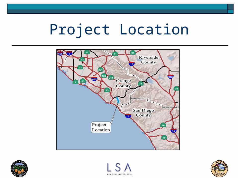
Project Location

3
Project Location

4
Project Background
La Pata Avenue included on Orange County Master Plan of Arterial Highways (MPAH) since 1963
La Pata and Camino Del Rio shown on City of San Clemente General Plan since 1982 and Talega and Forster Ranch Specific Plans
The existing La Pata Avenue built in the 1970s as a "dead-end" landfill access road
Project initiated in 2005. Three years of coordination with City and resident groups resulted in an alignment responding to concerns of proximity, light and glare, and aesthetics.

5
Project Location

6
Project Purpose and Objectives
Implement Orange County MPAH, Circulation Elements of San Clemente and San Juan Capistrano, and Specific Plans for Talega and Forster Ranch
Provide north/south access for local traffic
Improve access to schools, commercial areas, and recreational amenities
Improve emergency access
Reduce Vehicle Miles Traveled (VMT) and greenhouse gas emissions

7
Project Purpose and Objectives(continued)
Facilitate local inter-community circulation
Provide increased network capacity to support the forecast travel demand for the 2035 design year
Minimize impacts to utility transmission infrastructure
Minimize impacts to existing residential land uses
Minimize impacts to the natural environment

8
Proposed Project Alignment
9
Proposed Project
Widen La Pata Avenue from three to five lanes from Ortega Highway to the existing road terminus at the Prima Deshecha Landfill (PDL) – a distance of 9,600 feet
Construct four new lanes from the existing PDL terminus to Calle Saluda – a distance of 10,100 feet
Extend Camino Del Rio, as a four-lane roadway, from its existing terminus to the proposed Avenida La Pata – a distance of 1,700 feet
Estimated Total Cost: $77,368,000

10
Proposed Project Lighting will be provided along Camino Del Rio, on La Pata between
Calle Saluda and Camino Del Rio, and on La Pata north of the landfill entrance to the project limits.
Sidewalks will extend along Camino Del Rio to La Pata and on the west side of La Pata from Calle Saluda to Camino Del Rio and from Vista Montana north to the project limits.
Bike lanes will be provided along both La Pata and Camino Del Rio. San Clemente’s off-road bike path east of La Pata will be extended north to the city limits.
The roadway project requires grading of 9 million cubic yards. 3 million cubic yards are required to balance the roadway. The remaining 6 million cubic yards are required to stabilize a large landslide complex. All earthmoving is balanced on site.

11
Alternatives

12
Environmental Issues Addressed Aesthetics
(Views) Air Quality
(including Green House Gases)
Biological Resources Cultural Resources Geology and Soils
(landslides)
Hydrology and Water Quality
Hazards and Hazardous Materials
Land Use and Planning Noise Public Services and
Utilities Recreation
(Multi-use Trails)
Traffic and Circulation

13
Engineering Challenges and Solutions Community Impacts Electric Transmission Facilities Prima Deshecha Landfill Geology Water Quality

14
Design Challenges & Solutions Talega Community Workshops Horizontal & Vertical Alignment Refinements 7% Grade Design Deviation Berms to reduce visual impacts Forster Ranch Trailhead parking La Pata Trail Over-crossing Rubberized Asphalt to Reduce Noise Impacts

15
Electric Transmission Facilities Solution Early Coordination Workshops with SDG&E
and SCE 7% Grade Design Deviation Tower relocation Plan Coordinated with
SDG&E Facility Access Plans Incorporated into
Design
16
Prima Deshecha Landfill Solution Design Addresses Existing Access Requirements to
Zone 1 Design Addresses Future Access Requirements to
Zone 4 Three Bridge Structures eliminate need for
signalized intersection access Grade separations will maintain access to and
between Zone 1 and Zone 4

17
Landslides in Project Area

18
Landslide C Remediation Concept
9 million c.y. removal 2 million c.y. buttress fill 3 million c.y. to balance
roadway grading 4 million c.y.
recompaction consistent with landfill general development plan
9 million c.y. Excavation
2 million c.y.Buttress Fill

19
Geotechnical Solutions Identified Remediation Concepts to assure
construction feasibility Remediation Plan to accommodate roadway
construction and landfill operations Remediation Concept to balance earthwork on
site.

20
Water Quality Solutions Six water quality basins to provide load
reductions and detain runoff Bio-retention planter boxes proposed in
constrained right of way areas

21
Significant Unavoidable Impacts Traffic:
2016 – I-5 Northbound ramps/Avenida Pico and I-5 Northbound direct on-ramp from Crown Valley Parkway
2035 Without SR-241 Scenario – I-5 Northbound ramps/Avenida Pico Improvements currently being planned and funded by M2 will reduce
impacts.
Air Quality: Construction Emissions – CO, ROC, NOX, PM10, and PM2.5
Contributions to regional air quality thresholds Localized Impacts – Worst Case Assumptions
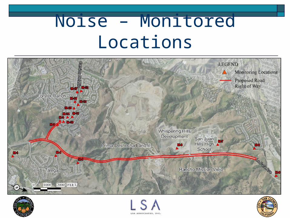
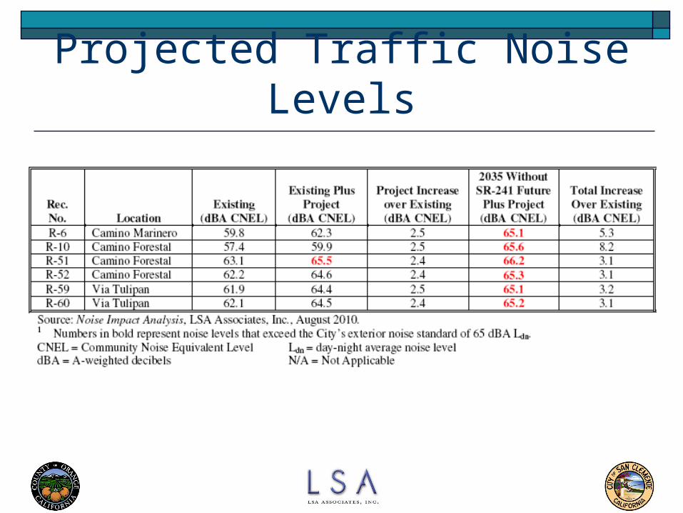
Noise: Increased traffic on Camino Del Rio forecast to exceed 65 dBA at 6 modeled locations Several 4-foot noise walls are recommended and will reduce
significant impacts.
22
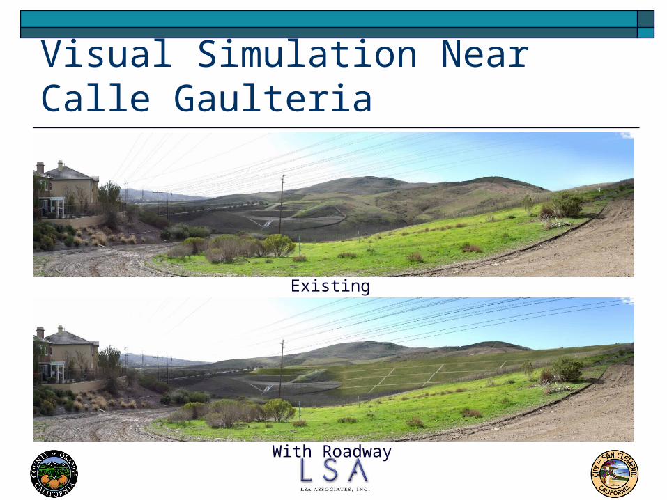
Visual Simulation Near Calle Gaulteria
Existing
With Roadway

23
Visual Simulation onForster Ranch Ridgeline Trail
Existing
With Roadway
24
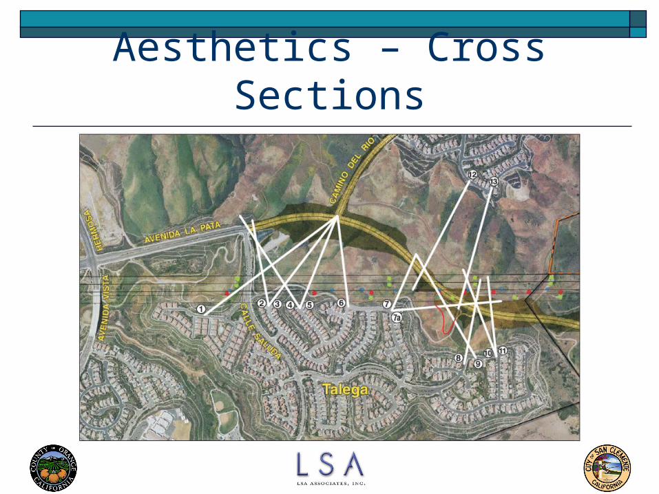
Aesthetics – Cross Sections

25

26

27

28

29
Traffic - Study Area

30
2016 Daily Traffic Volume
Without Project With Project
4
3353
282
39
136
5133
38
274

31
2035 Daily Traffic VolumeWithout SR-241
Without Project With Project
59
38
278
41
3135
64
38
54
336

32
2035 Daily Traffic VolumeWith SR-241
Without Project With Project
294
43
2851
5
5129
8 15291
41

33
Vehicle Miles of Travel A Comparison of daily vehicle miles travelled
(VMT) within the study area shows the following reductions as a result of the project.
Scenario VMT
2016 - 30,758
2035 Without SR-241 - 71,531
2035 With SR-241 - 29,115
34
Noise – Monitored Locations

35
Proposed Noise Mitigation (Del Rio)
36
Projected Traffic Noise Levels

37
Recreation
38
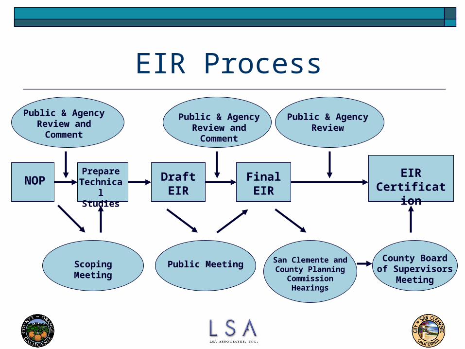
EIR Process
NOP
Public & Agency Review and Comment
Public & Agency Review and Comment
Public & Agency Review
Draft EIR
Final EIR
EIR Certification
Scoping Meeting Public Meeting San Clemente and County Planning
Commission Hearings
County Board of Supervisors
Meeting
Prepare Technical Studies
39
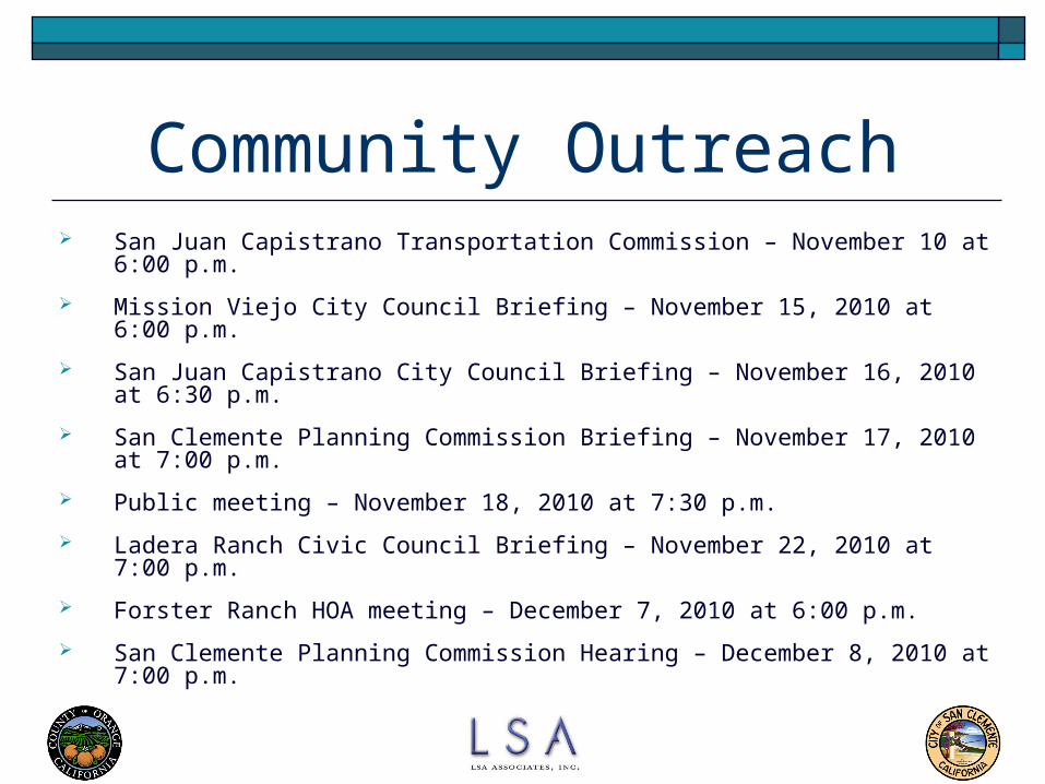
Community Outreach San Juan Capistrano Transportation Commission – November 10 at 6:00 p.m.
Mission Viejo City Council Briefing – November 15, 2010 at 6:00 p.m.
San Juan Capistrano City Council Briefing – November 16, 2010 at 6:30 p.m.
San Clemente Planning Commission Briefing – November 17, 2010 at 7:00 p.m.
Public meeting – November 18, 2010 at 7:30 p.m.
Ladera Ranch Civic Council Briefing – November 22, 2010 at 7:00 p.m.
Forster Ranch HOA meeting – December 7, 2010 at 6:00 p.m.
San Clemente Planning Commission Hearing – December 8, 2010 at 7:00 p.m.
40
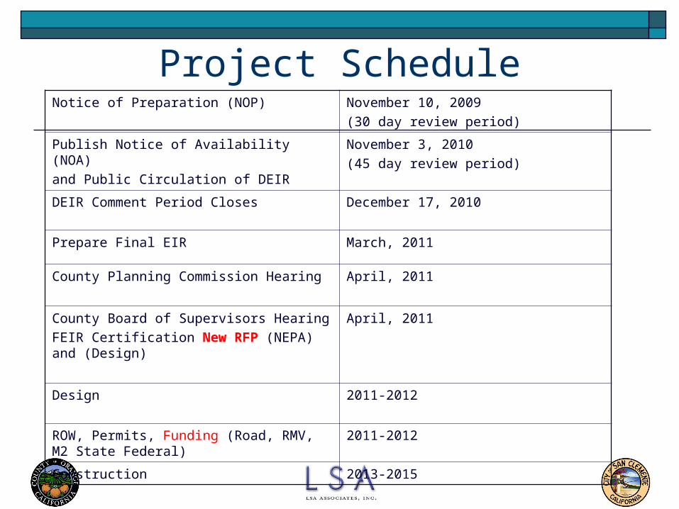
Project ScheduleNotice of Preparation (NOP) November 10, 2009
(30 day review period)
Publish Notice of Availability (NOA)
and Public Circulation of DEIR
November 3, 2010
(45 day review period)
DEIR Comment Period Closes December 17, 2010
Prepare Final EIR March, 2011
County Planning Commission Hearing April, 2011
County Board of Supervisors Hearing
FEIR Certification New RFP (NEPA) and (Design)
April, 2011
Design 2011-2012
ROW, Permits, Funding (Road, RMV, M2 State Federal)
2011-2012
Construction 2013-2015
41
Questions?


