www.abiresearch.com THE FUTURE OF MAPS: TECHNOLOGIES, PROCESSES, AND ECOSYSTEM Vice President: Dominique Bonte, Senior Analyst: James Hodgson 1. MAPS: BACKGROUND AND MARKET TRENDS 1.1 INTRODUCTION Maps remain critical elements across all consumer, mobility, and Internet of Things (IoT) use cases, powering a range of transformational paradigms, including location-based search, social networking, end-to-end freight tracking, and autonomous driving. Maps are at the heart of the smartphone, driverless vehicle, and IoT revolution. Maps are ubiquitous and taken for granted. However, new demands in terms of accuracy, attributes, functional safety, freshness and continuous updates, and quality requirements are turning map making into increasingly complex, high-tech, and expensive processes. While a growing ecosystem of new entrants and mapping startups are emerging, longstanding expertise and deep insight into data formats and local requirements remains critical. 1.2 KEY TRENDS The main trends in the role and use cases of maps are outlined below. 1.2.1. NEW MAPPING USE CASES Maps have traditionally mainly been used for outdoor road-based turn-by-turn navigation as part of automotive infotainment systems. A range of new use cases is now emerging: TABLE OF CONTENTS 1. MAPS: BACKGROUND AND MARKET TRENDS...................................................1 1.1 Introduction ......................................................1 1.2 Key Trends ........................................................1 1.2.1. New Mapping Use Cases...........................1 1.2.2. New Mapping Content..............................2 1.2.3. Globalization Trend...................................3 1.2.4. Developing Mapping Ecosystem................3 1.2.5. New Business Models...............................3 1.2.6. Open (source) Location and Mapping Platforms..................................................3 2. Building Maps: Data Sources, Technologies, Standards, and Processes....3 2.1 Technology Trends............................................3 2.1.1. Sensor Data Crowdsourcing......................3 2.1.2. Maps as a Sensor......................................4 2.1.3. Streaming Maps........................................4 2.1.4. Self-healing Maps......................................4 2.1.5. AI and Deep Learning.................................4 2.1.6. Cloud-based Storage and Processing.........4 2.1.7. HD Maps and Simultaneous Localization and Mapping.............................................4 2.1.8. Incremental Over-the-Air Updates of Maps......5 2.1.9. Vector and Tile-based Map Formats...........5 2.1.10. Integration of Location and Mapping into Chipsets.....................................................5
Transcript
www.abiresearch.com
THE FUTURE OF MAPS: TECHNOLOGIES, PROCESSES, AND ECOSYSTEM
Vice President: Dominique Bonte, Senior Analyst: James Hodgson
1. MAPS: BACKGROUND AND MARKET TRENDS1.1 INTRODUCTION Maps remain critical elements across all consumer, mobility, and Internet of Things (IoT) use
cases, powering a range of transformational paradigms, including location-based search,
social networking, end-to-end freight tracking, and autonomous driving. Maps are at the
heart of the smartphone, driverless vehicle, and IoT revolution. Maps are ubiquitous and
taken for granted. However, new demands in terms of accuracy, attributes, functional safety,
freshness and continuous updates, and quality requirements are turning map making into
increasingly complex, high-tech, and expensive processes. While a growing ecosystem of
new entrants and mapping startups are emerging, longstanding expertise and deep insight
into data formats and local requirements remains critical.
1.2 KEY TRENDS The main trends in the role and use cases of maps are outlined below.
1.2.1. NEW MAPPING USE CASESMaps have traditionally mainly been used for outdoor road-based turn-by-turn navigation
as part of automotive infotainment systems. A range of new use cases is now emerging:
1.2.1. New Mapping Use Cases...........................11.2.2. New Mapping Content..............................21.2.3. Globalization Trend...................................31.2.4. Developing Mapping Ecosystem................31.2.5. New Business Models...............................31.2.6. Open (source) Location and Mapping
2. Building Maps: Data Sources, Technologies, Standards, and Processes....32.1 Technology Trends............................................3
2.1.1. Sensor Data Crowdsourcing......................32.1.2. Maps as a Sensor......................................42.1.3. Streaming Maps........................................42.1.4. Self-healing Maps......................................42.1.5. AI and Deep Learning.................................42.1.6. Cloud-based Storage and Processing.........42.1.7. HD Maps and Simultaneous Localization
and Mapping.............................................42.1.8. Incremental Over-the-Air Updates of Maps......52.1.9. Vector and Tile-based Map Formats...........52.1.10. Integration of Location and Mapping into
2www.abiresearch.com THE FUTURE OF MAPS: TECHNOLOGIES, PROCESSES, AND ECOSYSTEM
• Safety and Mission-Critical Autonomous Vehicle (AV) Use Cases: The use of maps will be extended to more mission-critical applications like informational safety (Electronic Horizon), active safety, and Advanced Driver Assistance Systems (ADAS) (Level 2+, semi-autonomous driving, and lower levels of automation), as well as advanced levels of automation (Level 4 to 5), from positioning to humanized driving, providing visibility to vehicles beyond the reach of their onboard sensors in order to make autonomous driving more comfortable and reliable, based on advanced path planning and information redundancy, and the use of maps in driverless simulation and training.
• Pedestrian Navigation and Guidance: Key mapping use case for smartphones and wearables.
• Indoor Navigation: Emergence of indoor maps for in-building human and robotic navigation, guidance, delivery, and tracking in venues, airports, manufacturing plants, and warehouses.
• Non-Automotive IoT Use Cases: Non-automotive IoT use cases are also on the rise across segments like supply chain (goods location tracking), government, and smart cities (urban planning and management).
Figure 1: HD Maps for Autonomous Vehicles (Source: HERE)
1.2.2. NEW MAPPING CONTENT Closely linked to the new use cases described above, a range of new map content categories is added through
separate map layers and attributes:
• 3D Maps: The addition of 3D representations of building and various types of landmarks and content caters to a more intuitive and user-friendly navigation and guidance for both vehicles and pedestrians. This is culminating in the concept of High-Definition (HD) maps for driverless vehicles, including an accurate Three-Dimensional (3D) representation of the entire environment.
• Imagery: Street level, aerial, and satellite imagery are fast becoming essential components of maps, providing additional visual information for improved confidence and convenience. One of the major drawbacks of image-based content is the very low update frequency, which can be offset, to some extent, through community-based crowdsourcing of images. Imagery is also increasingly used for the (automated) generation of traditional maps and/or the addition of new map content categories like 3D buildings (see Figure 1), green spaces, and lane boundaries.
2.2 Mapping Standards.....................52.2.1. Navigation Data Standard....52.2.2. Sensoris...............................52.2.3. Adasis..................................52.2.4. Vector Tile 3.........................52.2.5. Open AutoDrive Forum........5
2.3 Requirements..............................62.4 Challenges...................................72.5 The Mapping Production Process.8
2.5.1. Map Data Sources...............82.5.2. Production Process..............82.5.3. Closed Loop Map Update
Processes.............................8
3.HERE: Strategy and Approach 93.1 HERE Profile and History..............93.2 Here Approach and Strategy........9
4www.abiresearch.com THE FUTURE OF MAPS: TECHNOLOGIES, PROCESSES, AND ECOSYSTEM
2.1.2. MAPS AS A SENSORMaps are becoming integrated into the wider sensor fusion concept, complementing and enhancing
onboard vehicle sensors and allowing off-loading on the fly computing to maps for lane keeping, traffic sign
recognition, and other functionalities.
2.1.3. STREAMING MAPSMaps are evolving from static-based maps to dynamic content repositories based on real-time sensor data
streamed in real time to devices and vehicles.
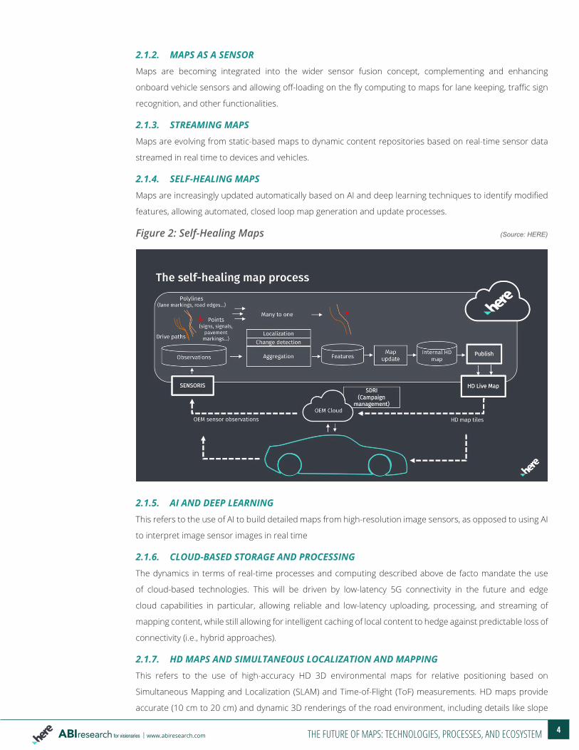
2.1.4. SELF-HEALING MAPSMaps are increasingly updated automatically based on AI and deep learning techniques to identify modified
features, allowing automated, closed loop map generation and update processes.
Figure 2: Self-Healing Maps (Source: HERE)
2.1.5. AI AND DEEP LEARNINGThis refers to the use of AI to build detailed maps from high-resolution image sensors, as opposed to using AI
to interpret image sensor images in real time
2.1.6. CLOUD-BASED STORAGE AND PROCESSINGThe dynamics in terms of real-time processes and computing described above de facto mandate the use
of cloud-based technologies. This will be driven by low-latency 5G connectivity in the future and edge
cloud capabilities in particular, allowing reliable and low-latency uploading, processing, and streaming of
mapping content, while still allowing for intelligent caching of local content to hedge against predictable loss of
connectivity (i.e., hybrid approaches).
2.1.7. HD MAPS AND SIMULTANEOUS LOCALIZATION AND MAPPINGThis refers to the use of high-accuracy HD 3D environmental maps for relative positioning based on
Simultaneous Mapping and Localization (SLAM) and Time-of-Flight (ToF) measurements. HD maps provide
accurate (10 cm to 20 cm) and dynamic 3D renderings of the road environment, including details like slope
5www.abiresearch.com THE FUTURE OF MAPS: TECHNOLOGIES, PROCESSES, AND ECOSYSTEM
and curvature of roads, lane markings, and roadside objects, such as sign posts, obtained using
Lidar-equipped data capture vehicles. While the need for maps is still questioned by some technology
vendors, touting the universal operation benefit of map-less systems, they represent a huge burden on
onboard computing power and have a lack of redundancy of information, which is relevant for highly
reliable operation.
2.1.8. INCREMENTAL OVER-THE-AIR UPDATES OF MAPSAs described above, streaming map updates are becoming a key requirement for keeping critical onboard
vehicle maps up-to-date. This is increasingly challenged by the cloud-based maps-as-a-service paradigm,
continuously streaming content from the cloud, as opposed to updated maps stored locally in vehicles.
2.1.9. VECTOR AND TILE-BASED MAP FORMATSNew map coding standards based on vectors and tiles are instrumental in reducing file sizes and enable
incremental updates.
2.1.10. INTEGRATION OF LOCATION AND MAPPING INTO CHIPSETS Location and mapping will be embedded at a chipset hardware level, enabling additional efficiencies and
seamless integration.
2.2 MAPPING STANDARDS2.2.1. NAVIGATION DATA STANDARDThe Navigation Data Standard (NDS) is a standardized binary database map format for automotive-grade
navigation databases, co-developed by car OEMs and suppliers. NDS supports compatibility and
interoperability, separation of application software and map data, and incremental updates. The
not-for-profit NDS Consortium is headquartered in Germany. Members include automotive OEMs, map data
providers, and navigation device and application providers (Daimler, BMW, VW, Hyundai, Nissan, Renault,
7www.abiresearch.com THE FUTURE OF MAPS: TECHNOLOGIES, PROCESSES, AND ECOSYSTEM
procedures will be critical. Building maps through vehicle data crowdsourcing and the inherent redundancy
that multiple, mutually independent sources provide contributes largely to the reliability of map-based
positioning in AVs.
2.4 CHALLENGES The mapping ecosystem currently experiences a range of changes, including:
• Lack of Standards: Despite ongoing standardization efforts, such as NDS, ADASIS, SENSORIS, TISA, etc., maps are still essentially proprietary datasets lacking interoperability between mapping suppliers. The lack of standards is also resulting in a need for hosting, development, and consulting services.
• Quality Control: It continues to prove very difficult to produce error-free maps. This is due to the high complexity of the environment and its dynamic nature, as well as quality management complexities when combining and matching huge datasets from a large number of sources.
• Cost: The complexity, the need for manual verification, and new requirements for fresh maps and global coverage result in high production costs. Higher efficiencies and improved productivity in map making remains hard to achieve.
• Business Models and Monetization: With a large number of mostly cloud-based free maps and navigation solutions now available, it is increasingly challenging to monetize standalone map datasets.
• Regulatory Limitations: In many countries, map making is highly regulated, with foreign suppliers often banned from operating locally, resulting in the need for setting up local alliances or joint ventures.
• Limitations of AI Tools: Despite advances in AI, automating the generation of maps remains problematic with manual verification based on local expertise and specialist knowledge acquired over many years. This makes it hard for startups to enter the mapping ecosystem. New entrants, as well as large tech vendors like Apple, have attempted to explore shortcuts in the map production process in terms of only using limited datasets (vehicle sensor data, satellite imagery) and the level of automation (heavily or uniquely relying on AI to extract features from either sensor data or satellite imagery) to build commercial maps. The evidence strongly suggests this is not sufficient to build high accuracy, near-error-free maps. A maximum number of complementary and verification data sources need to be used, combined with sophisticated semi-automated and manual verification tools.
• Size of Map Data Files: The size of maps has increased exponentially with higher accuracy requirements, especially in relation to HD 3D maps for driverless vehicles. This complicates sending map updates Over-the-Air (OTA) in terms of time, bandwidth usage, and cost requirements. But it also increases onboard storage and processing requirements (both in terms of computation and power consumption). This results in a need for light(er)weight 3D maps based on simplified models of the environment.
8www.abiresearch.com THE FUTURE OF MAPS: TECHNOLOGIES, PROCESSES, AND ECOSYSTEM
2.5 THE MAPPING PRODUCTION PROCESSProducing high-accuracy maps should be seen as a highly complex manufacturing process in terms of data
collection, data cleaning and verification, layer creation, quality control, and publication.
2.5.1. MAP DATA SOURCESThe following data sources are typically used to generate maps:
• Mapping Vehicles: Highly specialized vehicles with high-quality Lidar, imaging sensors, and high-precision Global Navigation Satellite System (GNSS); critical for generating high-quality base maps.
• Satellite Imagery: Important additional data source for automated feature extraction.
• Vehicle Sensor Data: Critical data source for real-time, self-healing maps; this includes data captured from both embedded systems and community-based aftermarket solutions.
• Government Data: Data obtained from national, state, county, and city governments. This is important for base maps data and is a source of planned road modifications.
• Community Feedback: Input provided manually by mapping community members.
• Other Data: Data obtained from utilities.
Sources vary in terms of freshness (varying from real time for sensor data to several years old for satellite
imagery), granularity and accuracy, geographical coverage, reliability, features and detail, and relevance.
Combined, they allow map makers to build (and update) high-accuracy maps.
2.5.2. PRODUCTION PROCESS The mapping production process involves a large number of sequential steps in what can be described as a
highly specialized manufacturing workflow:
• Data Capture: Aggregation of content from a large number of sources.
• Data Cleaning and Harmonization: Matching/comparing/consolidating various datasets and global and local formats; harmonization of incoming data. Increasing number of automated database validations.
• Map Layer Creation: Various map layers supporting existing and new use cases like driverless vehicles.
• Quality Assurance and Control: Critical step, especially as it relates to functional safety requirements for mission-critical applications; in the future, new technologies like blockchain can be used to ensure origin, authenticity, and accuracy of map data sources and organized trusted data flow management.
• Testing: Navigable map testing programs.
• Publication: Maps need to be made available in file formats that can installed and/or downloaded OTA to vehicles or made available as cloud-based maps in real time.
2.5.3. CLOSED LOOP MAP UPDATE PROCESSESWith the emergence of real-time self-healing maps, the production and update processes increasingly overlap
in what can be called a closed loop process of frequent incremental updates via OTA or continuous updates
via cloud-based maps. This is turning map creation into a 24-hour ongoing process, requiring production and
Information Technology (IT) infrastructure, not unlike advanced manufacturing plants.
9www.abiresearch.com THE FUTURE OF MAPS: TECHNOLOGIES, PROCESSES, AND ECOSYSTEM
3. HERE: STRATEGY AND APPROACHThis section takes a closer look at HERE’s position and strategies in the fast-changing mapping ecosystem.
3.1 HERE PROFILE AND HISTORY HERE’s history stretches back to the pioneering days of map making (NAVTEQ was created in 1985), and
subsequently being successively owned by Philips Electronics and Nokia. HERE is currently owned by a
consortium consisting of founding members Audi, Daimler, and BMW, with Intel, Bosch, and Continental
recently having joined as investors and taking stakes of 15%, 5%, and 5%, respectively. As the de facto
mapping leader, HERE commands and controls large parts of the automotive, enterprise, and, to a lesser
extent, consumer mapping environment.
3.2 HERE APPROACH AND STRATEGYHERE’s leadership is based on a combination of expertise acquired and tools developed over more than 30
years. It played a pioneering role in adopting and standardizing AI-based vehicle sensor data crowdsourcing
for map generation, self-healing maps, real-time maps (HD Live Map), and maps-a- a-sensor for AV operation.
Key strengths include:
• Mapping Expertise: HERE combines a wide range of assets, including map format conversion expertise, map making tools, local geographical knowledge, such as for street name coding, global training sets for feature recognition, etc., into a streamlined, efficient map “factory” infrastructure and processes. It employs a large number of cartography analysts and a global production staff.
• Access to Map Data Sources: HERE has access to and uses more than 80,000 different validated sources of data. Data on more than 2 million kilometers of roads per year are captured with hundreds of HERE TRUE mapping vehicles.
• Map Updates: HERE applies millions of map updates on a daily basis. Map release frequency has increased to bi-weekly, and for parts of the HD Live Map service, updates are already published multiple times per day.
• Map Layers: HERE offers a wide range of map content types, with increasing coverage of indoor maps (venues) in more than 60 countries, 3D landmarks allowing humanized navigation through Natural Guidance, transit layers in cities, street-level imagery, and HD maps for driverless vehicle testing. More than 400 attributes are coded per road segment.
10www.abiresearch.com THE FUTURE OF MAPS: TECHNOLOGIES, PROCESSES, AND ECOSYSTEM
Figure 5: HERE 3D Maps (Source: HERE)
• Scale: HERE’s operational capabilities allow building maps at scale on an industrial level. Map making far exceeds the narrow software engineering challenge, as is often uniquely focused on by new entrants. The really critical part is the “data maintenance factory” allowing the building maps at an industrial scale and at a consistent high quality.
• Global Coverage: Extensive coverage in terms of automotive-grade maps, in particular, achieved through decade-long efforts in traditional map making, community crowdsourcing, and partnerships. In this respect, the recently formed One Map Alliance with NavInfo of China, Increment P (IPC)/Pioneer of Japan, and SK Telecom of Korea is aiming for a single consistent HD map for driverless cars by 2020 for the Asian market. HERE’s maps allow routing algorithms to work globally.
• Vehicle Sensor Data: HERE has privileged access to real-time vehicle sensor data from consortium members Audi, BMW, and Daimler, combined with probe data from OEM clients and partners, resulting in the number of probes exceeding 20 billion per month.
• Partnerships: Next to a growing number of partners within the consortium, HERE has set up technology and a commercial partnership with NVIDIA, NavInfo, and IPC, a mapping subsidiary of Pioneer Corporation to enable global mapping solutions for the autonomous driving era.
• Open Location Platform (OLP): This is a single environment for location-centric development, including storage of and access to built-in HERE map data.
As explained above, the fleet of HERE TRUE high-end industrial-capture vehicles remains critical in producing
high-quality maps. These vehicles include state-of-the-art mapping technology, four 96-megapixel cameras, a
32-beam spinning Velodyne LiDAR camera, and an Inertial Measurement Unit (IMU) sensor unit. HERE TRUE
vehicles collect 700,000 3D data points at a time, accumulating more than 140 gigabytes of location data
ABI Research provides strategic guidance for visionaries needing market foresight on the most compelling transformative technologies, which reshape workforces,
identify holes in a market, create new business models and drive new revenue streams. ABI’s own research visionaries take stances early on those technologies,
publishing groundbreaking studies often years ahead of other technology advisory firms. ABI analysts deliver their conclusions and recommendations in easily and
quickly absorbed formats to ensure proper context. Our analysts strategically guide visionaries to take action now and inspire their business to realize a bigger picture.
For more information about ABI Research’s forecasting, consulting and teardown services, visionaries can contact us at +1.516.624.2500 in the Americas, +44.203.326.0140
in Europe, +65.6592.0290 in Asia-Pacific or visit www.abiresearch.com.
any kind for any company, product, or strategy. ABI Research is an independent producer of market analysis and insight and this ABI Research product is the result of
objective research by ABI Research staff at the time of data collection. ABI Research was not compensated in any way to produce this information and the opinions of ABI
Research or its analysts on any subject are continually revised based on the most current data available. The information contained herein has been obtained from sources
believed to be reliable. ABI Research disclaims all warranties, express or implied, with respect to this research, including any warranties of merchantability or fitness for a