BOARD OF DIRECTORS SAN JACINTO RIVER AUTHORITY MINUTES OF REGULAR MEETING MAY24, 2018 1 A regular meeting of the Board of Directors of the San Jacinto River Authority was held at 8:00 a.m., May 24, 2018, at the San Jacinto River Authority General and Administration Building, a notice of said meeting was posted as required by law. President Lloyd Tisdale, Secretary Mark Micheletti, Assistant Secretary Jim Alexander, Treasurer Ronnie Anderson, and Board Member Ed Boulware were present. Board Member Kaaren Cambio was not present. General Manager Jace Houston, Deputy General Manager Ron Kelling, Director of Financial and Administrative Services Tom Michel, Director of Raw Water Enterise David Parkhill, Public Relations Manager Ronda Trow, Woodlands Division Manager Chris Meeks, GRP Division Manager Mark Smith, Lake Conroe Division Manager Bret Raley, Highlands Division Manager Kim Wright, Administrative Services Manager Cynthia Bowman, Financial Advisor Ryan Nesmith, and General Counsel Mitchell Page were in attendance. 1. CALL TO ORDER The meeting was called to order at 8:02 a.m. Mr. Tisdale asked r a moment of silence in remembrance of the victims of recent tragedies on Lake Conroe. 2. PLEDGES OF ALLEGIANCE The Pledges of Allegiance were led by Mr. Tisdale. 3. PUBLIC COMMENTS Mr. Mike Bleier of Montgomery, Texas, Mr. Dennis Albrecht of Kingwood, Texas, Mr. Max Tezano, of Montgomery, Texas, Mr. Willard Morton of Montgomery, Texas, Ms. Amy Slaughter of Kingwood, Texas, Mr. Guy Sconzo of Kingwood, Texas, and Mr. Dan Krueger of Houston, Texas, spoke in reference to agenda item 6d2; Mr. Robert Westover of Kingwood, Texas, spoke about flooding associated with Hurricane Harvey. Without objection, the agenda was llowed out of order. 6. d. FLOOD MANAGEMENT 2. Update Regarding Proposed Seasonal Lowering of Lake Conroe on a Temporary Basis Mr. Houston reported that as of May 24, 2018, neither the Texas Commission on Environmental Quality nor the City of Houston had responded to the San Jacinto River Authority Board of Director's proposal of a temporary seasonal lowering of Lake Conroe. 4. DIVISION UPDATES a. G&A: Mr. Houston provided an update under agenda item 6d2.
Transcript
BOARD OF DIRECTORS
SAN JACINTO RIVER AUTHORITY
MINUTES OF REGULAR MEETING
MAY24, 2018
1
A regular meeting of the Board of Directors of the San Jacinto River Authority was held at 8:00 a.m., May 24, 2018, at the San Jacinto River Authority General and Administration Building, a notice of said meeting was posted as required by law. President Lloyd Tisdale, Secretary Mark Micheletti, Assistant Secretary Jim Alexander, Treasurer Ronnie Anderson, and Board Member Ed Boulware were present. Board Member Kaaren Cambio was not present. General Manager Jace Houston, Deputy General Manager Ron Kelling, Director of Financial and Administrative Services Tom Michel, Director of Raw Water Enterprise David Parkhill, Public Relations Manager Ronda Trow, Woodlands Division Manager Chris Meeks, GRP Division Manager Mark Smith, Lake Conroe Division Manager Bret Raley, Highlands Division Manager Kim Wright, Administrative Services Manager Cynthia Bowman, Financial Advisor Ryan Nesmith, and General Counsel Mitchell Page were in attendance.
1. CALL TO ORDER
The meeting was called to order at 8:02 a.m. Mr. Tisdale asked for a moment of silence in remembrance of the victims of recent tragedies on Lake Conroe.
2. PLEDGES OF ALLEGIANCE
The Pledges of Allegiance were led by Mr. Tisdale.
3. PUBLIC COMMENTS
Mr. Mike Bleier of Montgomery, Texas, Mr. Dennis Albrecht of Kingwood, Texas, Mr. Max Tezano, of Montgomery, Texas, Mr. Willard Morton of Montgomery, Texas, Ms. Amy Slaughter of Kingwood, Texas, Mr. Guy Sconzo of Kingwood, Texas, and Mr. Dan Krueger of Houston, Texas, spoke in reference to agenda item 6d2; Mr. Robert Westover of Kingwood, Texas, spoke about flooding associated with Hurricane Harvey.
Without objection, the agenda was followed out of order.
6. d. FLOOD MANAGEMENT
2. Update Regarding Proposed Seasonal Lowering of Lake Conroe on a Temporary Basis
Mr. Houston reported that as of May 24, 2018, neither the Texas Commission on Environmental Quality nor the City of Houston had responded to the San Jacinto River Authority Board of Director's proposal of a temporary seasonal lowering of Lake Conroe.
4. DIVISION UPDATES
a. G&A:
Mr. Houston provided an update under agenda item 6d2.
2
b. G & A:
Ms. Trow provided no update relative to the Public Relations Department.
c. G & A:
Mr. Michel provided no update relative to Finance and Administrative Services.
d. Woodlands:
Mr. Meeks provided no update relative to the Woodlands Division.
e. GRP:
Mr. Smith reported that the GRP Review Committee met on Monday, May 21, 2018, and unanimously recommended approval of the proposed Fiscal Year 2019 GRP Rate Order. He provided information relative to a proposed road-widening project and detention pond that impacted one of the GRP Division's water lines. Mr. Page provided a litigation update relative to the water line break on Segment W2B.
f. Raw Water:
Mr. Parkhill provided no update relative to the Raw Water Enterprise.
g. Lake Conroe:
Mr. Raley provided information and a brief overview of the administrative fees for the Lake Conroe licensing and permitting program as well as a rate schedule for fees related to the Lake Conroe Reservoir.
h. Highlands:
Ms. Wright provided no update relative to the Highlands Division.
i. Flood Management:
Mr. Gilman provided an update related to the Corps of Engineers' West Fork San Jacinto River emergency dredging activities.
5. CONSENT AGENDA
Mr. Alexander made a motion to approve the consent agenda as recommended. The motion was seconded by Mr. Micheletti and carried unanimously.
G&A
a. Approval of Minutes
Approve the minutes of the San Jacinto River Authority Regular meetings of March 22, 2018, and April 26, 2018.
b. Unaudited Financials for the Month of April, 2018
Approve the unaudited financials for the month of April, 2018.
WOODLANDS
c. Work Order No. 3 for Land Acquisition Support Services
3
Authorize the General Manager to execute Work Order No. 3 with Property Acquisition Services, LLC, in an amount not to exceed $48,000, for land acquisition support services for various utility line easements in The Woodlands.
6. REGULAR AGENDA
a. G&A
1. Annual Agreement for Financial Audit Services
Mr. Michel explained the selection process as well as the terms of the contract for financial auditing services. Mr. Anderson, Chair of the Finance Committee, stated that they met on May 11, 2018, to review the policies and procedures for selecting the firm. On behalf of the Finance Committee, Mr. Anderson stated that they agreed with staffs recommendation to select Knox Cox & Company, LLP, to provide said services. Mr. Anderson made a motion to authorize the General Manager to execute a contract with Knox Cox & Company, LLP, in the amount of $66,500, per year for annual financial audit services. The motion was seconded by Mr. Boulware and carried unanimously.
b. GRP
1. Amended Rate Order for GRP Participants
Mr. Smith stated that the GRP Review Committee met on Monday, May 21, 2018, and recommended approval of the amended rate order for Fiscal Year 2019, which proposed that rates remain unchanged from Fiscal Year 2018 (pumpage fee and import fee - $2.64 per 1,000 gallons, and surface water fee - $2.83 per 1,000 gallons). Mr. Alexander made a motion to adopt Order No. 2018-0-01, attached hereto as "Exhibit A", of the San Jacinto River Authority Board of Directors, adopting an amended Rate Order for GRP Participants, effective September 1, 2018. The motion was seconded by Mr. Anderson and carried unanimously.
c. RAW WATER ENTERPRISE
1. Assumption of Rights and Payment Obligations under the Option for Raw Water Supply Contract with the Trinity River Authority
Mr. Parkhill provided an overview of the rights and payment obligations related to the Trinity River Authority ("TRA") option for raw water supply contract. He stated that in 2013, the ultimate goal of this contract was to meet long term surface water demands in Montgomery County beyond the current available water supplies. He explained the contract granted the San Jacinto River Authority ("SJRA") the option to purchase 50,000 afpy of raw water from Lake Livingston with an option fee of 5%. Mr. Parkhill stated that since 2013, the GRP Division has paid the annual TRA option fee amount of $234,500, and that in February, 2018, the GRP Review Committee voted to no longer pay the fee with the understanding that SJRA could
4
either terminate the TRA option agreement and release any rights to the raw water, or SJRA could decide to retain the TRA option agreement and pay for the annual option fee through the SJRA Raw Water Enterprise and retain the contracted rights to the water. Mr. Parkhill explained that, if approved, the Raw Water Enterprise will assume the cost of the contracts and said funds will be included in the Raw Water Enterprise Fiscal Year 2019 budget. Mr. Anderson made a motion to approve the assumption of rights and payment obligations under the Option for Raw Water Supply Contract between the Trinity River Authority and the San Jacinto River Authority by the Raw Water Enterprise, effective September 1, 2018. The motion was seconded by Mr. Micheletti and carried unanimously.
d. FLOOD MANAGEMENT
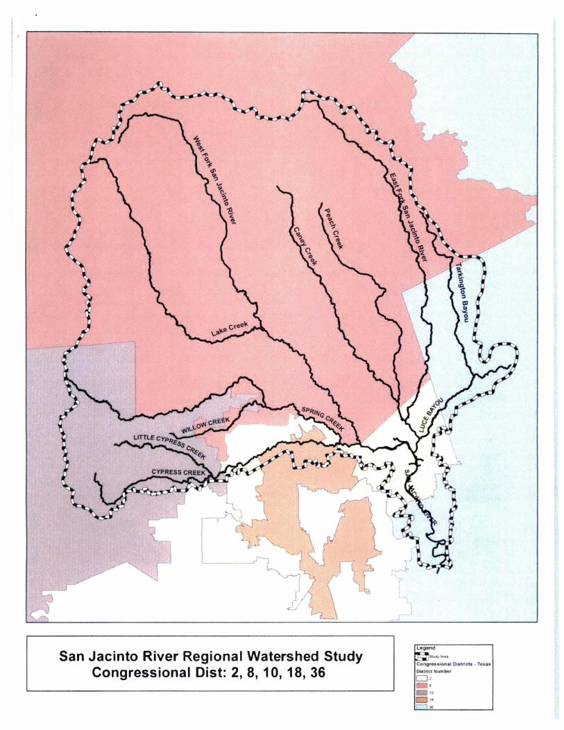
1. Resolution Authorizing Participation in San Jacinto River Regional Watershed Study
Mr. Gilman presented information related to the San Jacinto River Regional Watershed Study, stating that in January, 2018, the intent was to seek grants from the Texas Water Development Board to assist with the cost of the study. Further, he stated that since that time, Harris County Flood Control District ("HCFCD") submitted a grant application to the Texas Department of Emergency Management ("TDEM") pursuant to the Hazard Mitigation Grant Program to provide funding for the project. He stated that TDEM's grant provided for a higher match and reiterated that the project scope and SJRA's participation remained unchanged from the terms approved in January. Mr. Boulware made a motion to adopt Resolution No. 2018-R-09, attached hereto as "Exhibit B'', of the Board of Directors of the San Jacinto River Authority authorizing participation in San Jacinto River Regional Watershed Study and the execution of agreements in connection therewith. The motion was seconded by Mr. Alexander and carried unanimously.
7. BRIEFINGS AND PRESENTATIONS
a. Presentation regarding the Woodlands Division 10-Year Project Plan
Woodlands Division Engineer, Aaron Schindewolf, presented an overview of the Woodlands Di vision 10-Y ear Project Plan. He provided information for each project, detailing the funding source and fiscal year in which the projects would be funded. Mr. Schindewolf summarized that the total cost of all Woodlands projects through Fiscal Year 2028 is $207 ,398,000.
8. EXECUTIVE SESSION
The Board of Directors did not convene in executive session.
9. RECONVENE IN OPEN SESSION FOR ACTION FOLLOWING EXECUTIVE SESSION
No executive session was conducted.
10. ANNOUNCEMENTS I FUTURE AGENDA
Mr. Tisdale announced that the next San Jacinto River Authority Board of Directors meeting will take place on June 28, 2018.
5
11. ADJOURN
Without objection, the meeting was adjourned at 10:32 a.m.
Secretary, Board of Directors
Exhibit A
487873.1
SAN JACINTO RIVER AUTHORITY
RATE ORDER
(GRP PARTICIPANTS)
OrderNo. 2.D lB -Q -0 (
ADOPTED MAY 24, 2018 EFFECTIVE SEPTEMBER 1, 2018
TABLE OF CONTENTS
ARTICLE I FINDINGS; EFFECTIVE DATE; PRIOR RATE ORDER
WHEREAS, the San Jacinto River Authority (the "Authority"), is a conservation and reclamation district, body politic and corporate and a governmental agency of the State of Texas created and operating under the provisions of Chapter 426, Acts of the 45th Texas Legislature, Regular Session, 1937, as amended, enacted pursuant to the provisions of Section 59 of Article XVI of the Texas Constitution (the "Act"); and
WHEREAS, the Authority is authorized by the Act, and the general laws of the State to purchase, construct, acquire, own, operate, maintain, repair, improve, or extend, inside and outside its boundaries, any and all works, improvements, facilities, plants, equipment and appliances necessary to provide a water supply system for serving its needs and/or the needs of its customers; and
WHEREAS, the Authority has entered into certain contracts (the "Customer Contracts") for the financing, construction and operation of the Woodlands Water Supply System (as defined in the Customer Contracts) to serve the conservation and reclamation district customers of the Woodlands Division of the Authority; and
WHEREAS, each of the Customer Contracts has been amended and supplemented by a written addendum, dated as of November 10, 2009 (the "Addenda"), in order to address compliance with groundwater reduction requirements imposed by the Lone Star Groundwater Conservation District (the "Conservation District") and that are applicable to the Authority and the Woodlands Water Supply System; and
WHEREAS, the Authority has entered into contracts (the "GRP Contracts") with certain Large Volume Groundwater Users (as defined in the District Regulatory Plan of the Conservation District) in order to address compliance with groundwater reduction requirements imposed by the Conservation District that are also applicable to the water supply systems of such Large Volume Groundwater Users; and
WHEREAS, the Addenda and the GRP Contracts provide, in pertinent part, that the Authority will: (a) develop, implement, administer and enforce a groundwater reduction plan ("GRP") for the Woodlands Water Supply System and the water supply systems of such other participating Large Volume Groundwater Users (collectively, and inclusive of the Authority, the "Participants"); (b) plan, design, permit, construct, operate, maintain and administer a surface water treatment and transmission system, including all related facilities, improvements, appurtenances, property and interests in property and contract rights needed therefor, and administrative facilities needed in connection therewith (the "Project"); (c) furnish and sell treated surface water from the Project to certain of the Participants, as
- 1 -
feasible and necessary to implement the GRP; (d) assess fees on the pumpage of groundwater wells operated by the Participants; and ( e) utilize revenues derived from such treated surface water sales and pumpage fees to finance the Project and the GRP, including the pledge of such revenues to the payment
of, and as security for, the bonds or other obligations of the Authority issued or incurred to finance or refinance the Project and the GRP; and
WHEREAS, the Board of Directors of the Authority deems it necessary and proper at this time to establish certain fees, rates and charges applicable to the Participants, as authorized and required
under the Addenda and the GRP Contracts, in order to: (a) achieve and maintain compliance with the rules of the Conservation District and the GRP; (b) develop, implement, administer and enforce the GRP; (c) accomplish the purposes of the Addenda and the GRP Contracts, including making available alternative water supplies; ( d) recoup certain losses, damages, costs, interest or expenses; ( e) purchase, lease, reserve, option or contract for alternative water supplies, by, through or with third parties or the Authority; (t) meet operation and maintenance expenses related to the Project and the GRP; (g) pay certain capital costs, as well as the principal of and interest on certain notes, bonds and/or other obligations issued or incurred, or to be issued or incurred, in connection with the Project, the GRP or the Authority's obligations under the Addenda or the GRP Contracts; (h) satisfy all rate covenants relating to any of such notes, bonds and/or other obligations of the Authority; and (i) establish, accumulate, maintain or replenish one or more operating, debt service, contingency or emergency reserve funds, as deemed reasonably necessary by the Authority;
NOW THEREFORE, BE IT ORDERED BY THE BOARD OF DIRECTORS OF THE SAN JACINTO RIVER AUTHORITY THAT:
ARTICLE I
FINDINGS; EFFECTIVE DATE; PRIOR RATE ORDER
Section 1.01: Findings . Each of the recitals stated in this Rate Order are hereby adopted as findings of fact of the Board of Directors. All statutory and contractual requirements and conditions have been met for the establishment of fees, rates, and charges under this Rate Order.
Section 1 .02: Effective Date; Prior Rate Order. This Order shall be effective as of September 1, 2018 (the "Effective Date") . That certain prior Rate Order adopted by the Authority on May 25, 2017, designated as Order No. 2017-0-02, shall be repealed and superseded hereby in all respects as of the Effective Date.
ARTICLE II
DEFINITIONS; INTERPRET A TIO NS; REFERENCES
Section 2 .01: Definitions. In addition to terms defined elsewhere in this Rate Order, and unless the context requires otherwise, the following terms used in this Rate Order shall have the following meanings and, to the extent applicable, shall serve to supplement terms defined elsewhere in this Rate Order:
"Act" is defined in the recitals hereto and means and includes any amendments to the Act.
- 2 -
"Addenda" is defined in the recitals hereto and means and includes any amendments or supplements to the Addenda.
"Authority" is defined in the recitals hereto and means and includes the legal successors or assigns of the Authority.
"Authority Meters" has the meaning ascribed to such term in the GRP Contracts.
"AWS Well" means any groundwater well operated by any Participant, whether currently in operation or placed into operation hereafter, that produces water qualifying as an "Alternative Water Source" under the Rules .
"A WS Wells" means each and every A WS Well, collectively, whether one or more.
"Conservation District" is defined in the recitals hereto and means and includes the legal successors or assigns of the Conservation District.
"Contract Quantity" has the meaning ascribed to such term in the GRP Contracts.
"Conversion Date" means the date upon a Converted Participant shall begin making payment for Surface Water.
"Converted Participant" means a Participant receiving Surface Water from the Project.
"Converted Participant's Receiving Facilities" means the water plant or other water system facilities at the Point of Delivery where a Converted Participant receives Surface Water from the Project .
"Customer Contracts" is defined in the recitals hereto and means and includes any amendments or supplements to the Customer Contracts.
"Effective Date" is defined in Section 1.02 hereof.
"Fees" means the Pumpage Fee, the Import Fee and the Surface Water Fee, collectively.
"GRP" is defined in the recitals hereto and means and includes any amendments or supplements to the GRP.
"GRP Administrator" has the meaning ascribed to such term in the GRP Contracts .
"GRP Contracts" is defined in the recitals hereto and means and includes any amendments or supplements to the GRP Contracts .
"GRP Drought Contingency Plan" means the Drought Contingency Plan for San Jacinto River Authority GRP Division, adopted by the Board of Directors of the Authority on March 27, 2014, and any amendments or supplements thereto.
- 3 -
"GRP Water Conservation Plan" means the Water Conservation Plan for San Jacinto River Authority GRP Division, adopted by the Board of Directors of the Authority on March 27, 2014, and any amendments or supplements thereto.
"Import Fee" means the fee imposed under Section 3.02(a) hereof.
"Initial-Conversion-Obligation-Adjusted Total Qualifying Demand" or "!CO-Adjusted Total Qualifying Demand" has the meaning ascribed to such term under the Plan and generally means (a) for Total Qualifying Demand of 10 million gallons or greater, 70 percent of the Total Qualifying Demand or 10 million gallons, whichever amount is greater, and (b) for Total Qualifying Demand of less than 10 million gallons, the original Total Qualifying Demand.
"ORS" means the online reporting system offered and maintained by or on behalf of the
Authority, currently the "TrueBill" system or any successor system.
"Participant" means any of the Participants, without distinction.
"Participant Meters" has the meaning ascribed to such term in the GRP Contracts.
"Participants" is defined in the recitals hereto and means and includes the Authority, and any Large Volume Groundwater User that executes a GRP Contract with the Authority.
"Payment Commencement Date" has the meaning ascribed to such term in a Participant's GRP Contract with respect to such Participant, or August 1, 2010, with respect to the Authority, if applicable.
"Plan" means the District Regulatory Plan adopted by the Conservation District and includes any amendments, revisions or supplements thereto as may be adopted by the Conservation District on or after the Effective Date.
"Point of Delivery" has the meaning ascribed to such term in the GRP Contracts.
"Project" is defined in the recitals hereto and means and includes any and all extensions, modifications, enlargements or improvements to the Project permitted under the Addenda and the GRP Contracts.
"Pumpage Fee" means the fee imposed under Section 3.0l(a) hereof.
"Surface Water Fee" means the fee imposed under Section 3.03 hereof applicable to Surface Water delivered by and through the Project to a Converted Participant.
"Surface Water" means treated surface water delivered by and through the Project (i .e. , "Water" as defined under the GRP Contracts) .
"Total Qualifying Demand" has the meaning ascribed to such term under the Plan and generally means the final volume of groundwater that a permit holder is authorized under the terms of a permit issued by the Conservation District to produce from Wells in the Gulf Coast Aquifer (Chico, Evangeline and Jasper Aquifers) in calendar year 2009, as determined by the Conservation District in accordance with the Plan.
- 4 -
"Well" means any groundwater well operated by any Participant, whether currently in operation or placed into operation hereafter, that is subject to the groundwater reduction requirements set forth in the Plan. Accordingly, such term does not include any AWS Well.
"Wells" means each and every Well, collectively, whether one or more.
Section 2.02: Interpretations . The article, section, subsection and paragraph headings of this Rate Order are included herein for convenience of reference purposes only and shall not constitute a
part of this Rate Order or affect its interpretation in any respect . Except where the context otherwise requires, words imparting the singular number shall include the plural and vice versa. References to an entity refer to the legal successors of such entity, and to the board of directors, officers, or other officials of such entity where appropriate.
Section 2.03: References. For the avoidance of doubt, any reference in this Rate Order to a document shall mean such document and all exhibits thereto, as amended or supplemented from time
to time.
ARTICLE III
FEES AND RA TES
Section 3.01 : Pumpage Fee.
(a) General. Each Participant shall pay a Pumpage Fee of $2.64 per 1,000 gallons of groundwater pumped from its Wells during each whole or partial calendar month, beginning on the
later of the Effective Date or the Payment Commencement Date stated in such Participant's GRP Contract. Such pumpage of groundwater shall be metered by Participant in accordance with Article
VIII hereof and reported to the Authority in accordance with Article IV hereof. Payment of the Pumpage Fee shall be remitted to the Authority in accordance with Article V hereof.
(b) Exception. Notwithstanding paragraph (a) above, no Pumpage Fee shall be due with respect to Wells acquired by Participant that is a municipality if such Wells were formerly owned or operated by a conservation and reclamation district or entity that functioned under a groundwater reduction plan separate from the GRP, and such Participant has notified the Authority in writing that the Wells owned or operated by the district or entity will remain part of the groundwater reduction plan that is separate from the GRP. If a Participant is exempt, in whole or in part, from paying a Pumpage Fee pursuant to the above, then Participant shall submit a statement describing with reasonable detail the basis on such exemption in place of, or along with, payment to the Authority under Article V hereof.
Section 3.02: Import Fee.
(a) General. Each Participant shall pay an Import Fee of $2.64 per 1,000 gallons of water imported by Participant from any person or entity, during each whole or partial calendar month, beginning on the later of the Effective Date or the Payment Commencement Date stated in such Participant's GRP Contract. Such importation of water shall be metered by Participant as in accordance with Article VIII hereof and reported to the Authority in accordance with Article IV hereof. Payment of the Import Fee shall be remitted to the Authority in accordance with Article V hereof.
- 5 -
(b) Exceptions. Notwithstanding paragraph (b) above, no Import Fee shall be due if-
(1) such imported water was supplied to a Participant from another Participant;
(2) such imported water was derived from the re-use of water (from any source) or wastewater effluent;
or
(3) such imported water was derived from water withdrawn from an A WS Well;
(4) such importation is necessary due to an emergency impacting the ability of Participant to meet its water demands, the period of importation lasts for less than fifteen (15) consecutive days, and Participant has not imported water during more than thirty (30) days during the current calendar year.
If a Participant is exempt, in whole or in part, from paying an Import Fee pursuant to the above, then Participant shall submit a statement describing with reasonable detail the basis for the exemption along with, or in place of, payment to the Authority under Article V hereof.
Section 3.03: Surface Water Fee. Each Converted Participant shall pay a Surface Water Fee of $2.83 per 1,000 gallons of Surface Water delivered by and through the Project to the_Converted Participant's Receiving Facilities during each whole or partial calendar month, beginning on the later of the Effective Date or the Conversion Date. Such delivery of Surface Water shall be metered at the Point(s) of Delivery by Authority in accordance with Article VIII hereof and reported to the Converted Participant in accordance with Article IV hereof. Payment of the Surface Water Fee shall be remitted to the Authority in accordance with Article V hereof.
ARTICLE IV
REPORTING
Section 4.01: Self-Reporting .
(a) Measurement of Groundwater. Each Participant shall be responsible for measuring the amount of groundwater pumped from each of its Wells and/or A WS Wells by reading the Participant Meters on the Payment Commencement Date and on the first day of every month thereafter.
(b) Measurement of Imported Water. Each Participant shall be responsible for measuring the amount of water imported from any non-Participant by reading the Participant Meters on the Payment Commencement Date and on the first day of every month thereafter. A Participant shall not be responsible for measuring the amount of water imported from another Participant.
(c) Measurement of Surface Water. The Authority shall be responsible for measuring the amount of Surface Water supplied to each Converted Participant by reading the Authority Meters on the Conversion Date and on the first day of every month thereafter. Such reading shall generally be conducted remotely but from time to time may be conducted by direct reading by the Authority or its agents .
- 6 -
( d) Other Measurement. In order to monitor Participant water demands, the GRP Administrator may implement reasonable procedures to directly or indirectly measure (1) water imported from another Participant, and (2) water demands met by a Participant with water derived from the re-use of water (from any source) or wastewater effluent. Such procedures shall not require the installation of meters unless such installation is at the cost and expense of the Authority.
(e) Reporting. Water usage measured by the Participant (even if zero) shall be reported to the Authority by submitting readings through ORS or, if applicable, by submitting readings on a completed reporting form provided by the Authority. Reports must be received by the Authority on or before the 10th day of the first calendar month for which water usage is required to be measured incurred (e.g. , water usage measured during September, 2018, must be reported by October 10, 2018, and payment of any associated Fees will be due on November 18, 2018; water usage measured during October, 2018, must be reported by November 10, 2018, and payment of any associated Fees will be due on December 18, 2018; etc.). Surface Water usage measured by the Authority Meters shall be made available by the Authority to the Converted Participant through ORS. The GRP Administrator may provide a form to be submitted to the Authority in writing to supplement reporting through ORS with respect to any category of water usage that is not then supported through the ORS reporting system. In addition, the GRP Administrator will provide a form that may be submitted to the Authority in writing to report usage as an alternative to reporting same through ORS but only upon the request of Participant.
Section 4.02: Failure to Report . In the event a Participant fails or refuses to read its Participant Meters, the Authority shall have the right, but not the obligation, to read the Participant Meters. In the event that a Participant fails or refuses to read its Participant Meters on the Payment Commencement Date, the Authority shall have the right to read the Participant Meters on two or more occasions in order to calculate Participant's average daily usage and, based upon such calculation of average daily usage, to estimate the reading of the Participant Meters as of the Payment Commencement Date. If the Authority is required to read the Participant Meters, such Participant will be charged an inspection fee of $250, and any Fees due under Article III hereof shall be calculated based upon the Authority's readings or average daily usage, if necessary, regardless of when the Authority reads the Participant Meters.
Section 4.03 : Direct Reading . As provided in the GRP Contracts, the Authority may, by amendment, revision or restatement of this Rate Order, modify or repeal self-reporting procedures applicable to the Participant Meters and require readings by the Authority or its agents.
ARTICLE V
PAYMENT OF FEES
Section 5 .01 : Payment of Fees .
(a) ORS Reporting. Once all Participant Meter readings have been entered into ORS pursuant to Section 4.01 hereof, each Participant shall print its statement of Fees from the ORS and deliver the statement to the Authority with full payment, on or before the due date specified in Section 5.03 hereof.
- 7 -
(b) Form Reporting. If a Participant does not report through ORS, or must supplement reporting through ORS, then such Participant shall calculate Fees due the Authority for a given calendar month on the form provided by the GRP Administrator and deliver the completed form to the Authority with full payment, on or before the due date specified in Section 5 .03 hereof.
Section 5.02: Manner and Method of Payment.
(a) All Fees due the Authority under Sections 5.01 hereof, and any other fees, rates or charges payable to the Authority under this Rate Order, shall be paid in money which is legal tender in the United States of America. Payments will be accepted only by check or money order made payable to the " San Jacinto River Authority" , or by wire transfer according to written wiring instructions provided by the Authority. No cash will be accepted. Written wire instructions are available upon request.
(b) For purposes of submitting payments, ORS fee statements, reporting forms, or other documents pursuant to this Rate Order, the address of the Authority shall be as set forth below.
San Jacinto River Authority Attn: GRP Administrator GRP Division P.O. Box 329 Conroe, TX 77305
Section 5.03: Due Date. A ORS fee statement or a completed reporting form, and payment of all Fees due under Article III hereof, must be received by the Authority on or before the 18th day of the second calendar month following the whole or partial calendar month for during which such Fees were incurred (e.g. , water usage measured during September, 2018, must be reported by October 10, 2018, and payment of any associated Fees will be due on November 18, 2018; water usage measured during October, 2018, must be reported by November 10, 2018, and payment of any associated Fees will be due on December 18, 2018; etc .).
Section 5 .04: Self-Remission. Each Participant shall be responsible for remitting payment to the Authority for Fees on or before the due date specified under Section 5.03 hereof. The Authority will not and shall not be obligated to send an invoice or bill to a Participant for Fees unless the Authority, except to the extent that the Authority reads the Participant Meters under Sections 4 .02 or 4 .03 hereof. In such case, the Fees and any related charges owed by a Participant hereunder shall be specified in a written invoice promptly delivered to such Participant by the Authority. Such invoice shall specify thereon a due date for payment, which due date shall not be less than ten (10) days after the date of the invoice.
ARTICLE VI
CONSERVATION DISTRICT PERMITTING; OTHER INFORMATION
Section 6.01: Applicability of Conservation District Permitting Requirements . The GRP provides that the Authority will reduce groundwater production from the Gulf Coast Aquifer (Chico, Evangeline and Jasper Aquifers) by certain Participants so that, collectively, all Participants achieve and maintain compliance with the Plan. This will be achieved primarily through the Authority's
- 8 -
delivery of Surface Water to the Converted Participants and the consequent reduction in groundwater production from the Wells owned and operated by such Converted Participants. The development of other alternative water supplies (such as groundwater production from A WS Wells and water supplies developed from re-use projects) and the impacts of water conservation may further reduce groundwater production by Participants. Based upon the foregoing, the GRP is a "Joint GRP" as defined in and for all purposes of Phase II(B) of the Plan. The Authority, as administrator of the GRP, and all Participants are subject to the permitting requirements applicable to Joint GRPs under Phase II(B) of the Plan.
Section 6.02: Summarv of Permitting Reguirements; A WS Wells Excluded. (a) The Conservation District is to provide notice of Well permit renewals to the Authority and to all Participants included in the GRP on an annual basis. Under Phase II(B) of the Plan, the GRP Administrator is obligated to then prepare and provide to the Conservation District, not later than September 1, a schedule (the "Production Schedule") of the amount of groundwater each Participant will be authorized to produce from its Well(s) during the following calendar year. The Production Schedule must demonstrate that the Participants, collectively, will achieve the Initial Conversion Obligation for the aggregated Total Qualifying Demand of all Participants and otherwise meet the Conservation District's groundwater reduction requirements under the Plan. The Conservation District is to review and take action on the Well renewal permit application(s) and the accompanying Production Schedule in accordance with the Plan and the Conservation District's Rules.
(b) Under Phase II(B) of the Plan, the Authority has no right or obligation to process renewal permits for AWS Wells owned, operated or maintained by Participants . Accordingly, each Participant shall be responsible for securing, renewing, and otherwise maintaining permits for the Participant's A WS Wells.
Section 6 .03 : Implementation of Permitting Reguirements by GRP Administrator.
(a) Production Schedule. In order to timely process permit renewals for all Participant Wells included in the GRP, develop the Production Schedule, and otherwise comply with applicable permitting requirements under Phase Il(B) of the Plan, the Authority hereby adopts the following procedures.
(1) On an annual basis, the GRP Administrator shall determine, in his or her reasonable discretion, the proposed amount of groundwater each Participant will be authorized to produce from its Well(s) during the following calendar year. In making such determination, the GRP Administrator shall for each Participant (i) estimate the Participant's projected water demands for the following calendar year based upon the Participant's historical water demands and projected water demands, as reflected in the Participant's GRP Contract, and based upon the Participant's actual reported production from its Well(s), and (ii) estimate the sources of supply necessary to meet the Participant's projected water demand for the following calendar year, including but not limited to the Participant's !CO-Adjusted Total Qualifying Demand, Surface Water to be delivered to the Participant, if any, and any other alternative water supplies that may be used to supplement or supplant groundwater production from the Participant's Well(s) . To the extent that a Participant's projected water demands exceed the Participant's sources of supply, the GRP Administrator shall allocate additional groundwater production from the Gulf Coast Aquifer made available through the GRP to such Participant.
(2) Not later than July 1, the GRP Administrator shall provide each Participant with written notice of the proposed amount of groundwater each Participant will be authorized
- 9 -
to produce from its Well(s) during the following calendar year. Each Participant shall have the opportunity to submit written comments to same to the GRP Administrator at the address specified in the notice or, if no address is so specified, at the address set forth in Section 5 .02(b) hereof. Any comments must be received by the GRP Administrator on or before August 15.
(3) The GRP Administrator shall reasonably consider all comments received from the Participant and, in connection therewith, prepare a final Production Schedule for the GRP and all Participants.
(4) On or before September 1, the GRP Administrator shall submit the final Production Schedule to the Conservation District for review and approval .
(b) Renewal Filings. The GRP Administrator shall sign renewal application(s) on behalf
of all the Participants and their Wells included in the GRP, and take all other actions necessary to secure the annual renewal of permits for such Wells by the Conservation District. To the extent required by the Conservation District, each Participant shall execute any necessary permit renewal application materials reasonably requested by the GRP Administrator. Unless otherwise extended by the GRP Administrator, such materials shall be provided to the GRP Administrator no later than thirty
(30) days following receipt of a written request for same.
( c) Notice of Renewal. If not otherwise provided by the Conservation District, the GRP Administrator shall provide each Participant with a copy of the renewed permit(s) for the Participant's Wells within thirty (30) days following receipt of same by the Authority.
Section 6 .04 : Amendments to Production Schedule and Conservation District Permits; Total Qualifying Demand.
(a) Request for Amendment of Production Schedule and/or Permit Amount. A Participant
may from time to time submit a written request to the GRP Administrator for an increase, or a decrease, of the annual amount of groundwater authorized to be produced from the Participant's Well(s) under the Production Schedule and/or under the Participant's Conservation District permit(s) . The GRP Administrator shall consider the request and approve of same if, after giving effect to such request, the GRP Administrator determines that the Participants will achieve the Initial Conversation Obligation for the aggregate Total Qualifying Demand of all Participants . If the request is approved, the GRP Administrator shall notify the Participant in writing and prepare an amendment to the Production Schedule to reflect the approved request . Further, the GRP Administrator shall file and prosecute an application with the Conservation District to reflect the approved request, as and if required by the Conservation District. Each Participant shall execute any necessary amendment application materials reasonably requested by the GRP Administrator to file and prosecute such an amendment. Unless otherwise extended by the GRP Administrator, such materials shall be provided to the GRP Administrator no later than thirty (30) days following receipt of a written request for same. If the request is denied or conditioned, the GRP Administrator shall notify the Participant in writing of the reasons therefor.
(b) Approval of Production Schedule and/or Permit Amendment by Conservation District. The GRP Administrator shall provide the Participant requesting an amendment to the Production Schedule with written notice of the approval or denial of such request within thirty (30) calendar days thereafter. Notice of approval of a request shall be accompanied by a revised Production Schedule reflecting approved request. Further, if a permit amendment must be approved by the Conservation
- 10 -
District to reflect an amendment pursuant to subsection (a), above, the GRP Administrator shall notify the Participant of same within thirty (30) calendar days of approval by the Conservation District and provide the Participant with a copy of the Conservation District approval and the amended permit.
(c) Adjustment of Permitting Fees. If a request for a permit increase or decrease is approved pursuant to a request made under subsection (a), above, the GRP Administrator shall issue an invoice or credit to the Participant for associated Conservation District perming fees in accordance with Section 6.06 hereof.
(d) Total Qualifying Demand. In order to ensure that the Total Qualifying Demand of the Participants, collectively, is available for allocation in accordance with the GRP and the Production Schedule, no Participant shall sell, transfer, or otherwise dispose of Total Qualifying Demand without the prior written consent of GRP Administrator, which consent must receive prior approval by the
Review Committee and the Authority's Board of Directors .
Section 6 .05: Permits Binding; Penalties and Disincentive Fees. (a) Under Phase Il(B) of the Plan, the Conservation District's approval of a Participant's Well permit application and the applicable information in the Production Schedule shall be a condition of the renewed permit and shall be binding upon the Authority, as administrator of the GRP, and upon the Participant.
(b) If a Participant produces groundwater from its Well(s) in excess of the total authorized production reflected under the Conversation District permit for the Well(s), the Participant shall pay the Authority for any Conservation District disincentive fees or penalties assessed against the GRP as a result. The GRP Administrator shall provide a written invoice to the Participant for any disincentive fees or penalties due hereunder. Such invoice shall specify thereon a due date for payment, which due date shall not be less than ten ( 10) days from the date of the invoice. All disincentive fees or penalties invoiced hereunder shall be in addition to, and not in substitution for, any other Fees or amounts owed the Authority.
Section 6.06: Pass-Through of Permitting Fees. (a) Under Phase II(B) of the Plan, the Authority is responsible for payment of all Conservation District permitting fees (including, but not limited to, water use fees, groundwater transport fees, and administrative fees) associated with all Participant Well permits in the GRP. Accordingly, the GRP Administrator shall pass-through such fees to the Participants by providing a written invoice to each Participant, on a quarterly basis, for Conservation District permitting fees due in respect of the Participant's Well permit(s) . Such invoice shall specify thereon a due date for payment, which due date shall not be less than sixty (60) calendar days from the date of the invoice.
(b) If a request for an increase of the annual amount of groundwater authorized to be produced from a Participant's Well(s) is approved pursuant to Section 6.04 hereof, the GRP Administrator shall pass-through any resulting Conservation District permitting fees to the Participant by providing a written invoice for same to the Participant. Such invoice shall specify thereon a due date for payment, which due date shall not be less than sixty (60) days from the date of the invoice, or the date that is ten (10) calendar days before payment is due from the Authority to the Conservation District, whichever occurs first in time. As an alternative to the foregoing, at the option and discretion of the GRP Administrator, the GRP Administrator may add any such Conservation District permitting fees to the next ensuing quarterly invoice provided to the Participant under subsection (a), above.
- 11 -
(c) If a request for a decrease of the annual amount of groundwater authorized to be produced from a Participant's Well(s) is approved pursuant to Section 6 .04 hereof, the GRP Administrator may pass-through a credit for Conservation District fees paid or due with respect to the reduction, subject to the ability of the GRP Administrator to allocate the reduction in pumpage to other Participants requesting an increase in pumpage and to collect additional permitting fees from such other Participants to pass-through the credit. As and if approved, such credit shall be due from and paid by the Authority within sixty (60) days from the date of receipt of such credit from the Conservation District. As an alternative to foregoing, at the option and discretion of the GRP Administrator, the GRP Administrator may apply any such Conservation District credit to the next ensuing quarterly invoice provided to the Participant under subsection (a), above.
( d) In the event that the amount of groundwater actually produced from the Participants' Wells in a given year is less than the annual amount of groundwater projected to be produced from the Participants' Wells in such year, as shown on the current Production Schedule for such year, the GRP Administrator shall file an application with the Conservation District for a credit of permit fees paid by the GRP. Any credit approved by the Conservation District shall be passed through to the Participants on a pro-rata basis (based on amount of under production) and shall be applied to the next ensuing quarterly invoice provided to the Participant under subsection (a), above; provided, however, a Participant must have actually produced 75% or more of the groundwater authorized to be produced in such year in order to be eligible to receive such credit unless such requirement is waived by the GRP Administrator in his or her sole discretion.
Section 6.07 : Notice of Permit Filings . A Participant shall provide the GRP Administrator with a copy of any permit application filed with the Conservation District within ten ( 10) business days after filing, but only if such filing (1) requests a permit for the installation of a new Well or A WS Well, (2) relates to the removal, abandonment or closure of an existing Well or AWS Well, (3) requests an increase or decrease in annual groundwater pumpage, or (4) relates to the transfer, assignment or termination of a Conservation District permit held by Participant.
Section 6 .08 : Other Documents or Information. A Participant shall provide the GRP Administrator with copies of documents or other reasonably available or ascertainable information, data or materials date that, as determined by GRP Administrator, is necessary in connection with the implementation of the GRP. Unless otherwise extended by the GRP Administrator, such documents, information, data or materials shall be submitted to the GRP Administrator no later than thirty (30) days following receipt of a written request for same.
ARTICLE VII
LATE FEES; INTEREST CHARGES; COLLECTIONS
Section 7.0 1 : Late Fees . Fees due under Article III hereof shall be increased by 5% if not paid on or before the due date specified under Section 5 .03 hereof. Amounts due under Article VI hereof shall be increased by 5% if not paid on or before the due date specified on an invoice therefor. Any other amounts due under this Rate Order shall be increased by 5% if not paid on or before the due date specified on an invoice therefor.
- 12 -
Section 7 .02: Interest Charges. Overdue amounts (including applicable late fees) shall accrue interest at 12% per annum (i .e . , 1 % per month) for each whole or partial calendar month such payment is past due.
Section 7 .03 : Invoice for Late Fees and Interest Charges . The Authority will provide a written
invoice to a Participant for any late fees or interest charges due under Section 7 .01 and/or 7 .02 hereof. Such invoice shall specify thereon a due date for payment, which due date shall not be less than ten (10) days from the date of the invoice.
Section 7 .04 : Collection Costs . If the Authority is required to incur costs to collect an overdue account, all such costs, including reasonable attorney's fees, court costs and expenses, shall be paid by the delinquent Participant, and the Authority shall be entitled to collect such costs in any suit for collection of a delinquent account.
ARTICLE VIII
METERING AND CALIBRATION
Section 8 .01 : Maintenance and Testing of Meters. The provisions of Section 5 .03 of the GRP Contracts, relative to the maintenance, testing and calibration of Participant Meters and Authority Meters, are incorporated herein for all purposes . The provisions of Section 5 .05 of the GRP Contracts, relative to the resolution of disputes concerning tests of Participant Meters and/or Authority Meters, are incorporated herein for all purposes .
In the event that Participant fails or refuses to test and calibrate the Participant Meters in accordance with such provisions of the GRP Contracts, the Authority shall have the right, but not the obligation, to test and calibrate the Participant Meters. If the Authority so tests and calibrates the Participant Meters, such Participant will be charged a fee of $250 plus the Authority's actual and direct expenses for such testing and calibration. Such fee shall be specified in a written invoice promptly delivered to such Participant by the Authority, and the invoice shall specify thereon a due date for payment, which due date shall be less than then (10) days after the date of the invoice.
Section 8 .02 : Audits . The Authority shall have the right to audit the readings from Participant Meters by examining the books and records of a Participant, reading such Participant Meters, or by any other means and methods prescribed by the Authority.
Section 8 .03 : Right to Enter Land. The Authority and its representatives shall have the right to enter upon the land of a Participant, at any reasonable time in order to audit the readings of the Participant Meters, to read Participant Meters in the event a Participant has failed or refused to do so, to directly read any Authority Meters, or to perform testing and calibration of the Participant Meters in the event Participant has failed or refused to do so.
Section 8.04: Adjustments. The provisions of Section 5.04 of the GRP Contract, relative to the adjustment of pumpage measured by inaccurate Participant Meters and/or Authority Meters, are incorporated herein for all purposes.
- 13 -
ARTICLE IX
CONVERSION TO SURFACE WATER
Section 9 .01 : Terms of Service. Surface Water shall be provided by the Authority and received and used by a Converted Participant in accordance with the terms and conditions set forth in the GRP Contract. Without limiting the foregoing, the Authority specifically incorporates by reference the following provisions of the GRP Contracts : Section 4.09 (Contract Quantity, relating to force majeure, penalties for failure to take the Contract Quantity, and use of groundwater wells and other sources of supply to meet demands); Section 4 .10 (Warranties Regarding Water) ; Section 4 .12 (Passing of Title to Water; Re-use); Section 10.02 (Delivery Limitations); and Section 12.03 (Continuation of Service) .
Section 9.02: Failure to Take Contract Quantity . If a Participant fails or refuses to timely connect to the Project in accordance with Section 4.07 of the GRP Contracts, or if a Converted
Participant has connected to the Project and fails or refuses to at least take the Contract Quantity designated by the GRP Administrator, the GRP Administrator may impose penalties under Section 11 .03 hereof.
ARTICLE X
DROUGHT CONTINGENCY AND WATER CONSERVATION
Section 10.01: Updating and Submittal of Plans. In accordance with Section 3.05 of the GRP Contracts, all Participants must adopt and enforce a water conservation plan (see 30 T .A. C . § § 28 8 .1-288 . 7), as well as a drought contingency plan (see 30 T.A.C. §§ 288 .20-288 .22), that meets the minimum requirements adopted by the Authority under the GRP Water Conservation Plan and the GRP Drought Contingency Plan. Unless otherwise extended by the GRP Administrator, such plans shall be submitted to the GRP Administrator no later than thirty (30) days following receipt of a written request for same.
Section 10.02: Drought Management Surcharge. The goal of the GRP Drought Contingency Plan is to reduce the total water demand of all Participants by targeted percentages in response to various stages of drought or due to emergency conditions. Accordingly, the GRP Administrator may impose a surcharge on water usage to enforce the GRP Drought Contingency Plan during any whole or partial calendar month in which Stages 2 through 4 of the GRP Drought Contingency Plan has been triggered, or during any Emergency Water Supply Condition under the GRP Drought Contingency Plan. The surcharge on Fees shall only apply to the extent that Participant's actual water usage (as determined by the Authority based upon reporting information submitted pursuant to Article IV hereof) exceeds targeted water usage (as calculated pursuant to Section 3 .6 of Drought Contingency Plan and reduced by the applicable percentage). The surcharge on Fees shall be calculated based upon the maximum civil penalty rate that may be imposed by the Conservation District on Large Volume Groundwater Users that are not part of a GRP under the Plan (currently $4 .00 per 1,000, which is subject to increase hereafter) unless a lesser rate is determined to be sufficient to achieve compliance by the GRP Administrator. The surcharge shall be in addition to any other Fees or other amounts due to the Authority.
- 14 -
ARTICLE XI
PENALTIES; RECOVERY; VIOLATION OF RATE ORDER
Section 11 .01: Generally Applicable Penalties.
(a) Reporting. A Participant shall be subject to penalties for failure or refusal to report water usage to the Authority in accordance with Section 4 .01 hereof.
(b) Calibration. A Participant shall be subject to penalties for failure or refusal to timely calibrate its Participant Meters in accordance with Section 8.01 hereof and/or the GRP Contracts .
(c) Access to Meters. A Participant shall be subject to penalties for failure or refusal to provide timely access to any Participant Meters or Authority Meters in accordance with Section 8.03 hereof and/or the GRP Contracts.
(d) Documents. A Participant shall be subject to penalties for failure or refusal to timely provide the GRP Administrator with documents, information, data or materials requested under this Rate Order.
(e) Water Conservation and Drought Contingency Plans. A Participant shall be subject to penalties for failure or refusal to -
(1) timely submit the Participant's water conservation plan or drought contingency plan to the Authority in accordance with Section 10 .01 hereof and/or the GRP Contracts;
(2) include provisions in the Participant's water conservation plan or drought contingency plan that meet minimum criteria established by the Authority in accordance with the GRP Contract; or
(3) implement or enforce the Participant's water conservation plan or drought contingency plan.
(t) Bond Sale Documents. If the Authority provides Participant with a written request that certain documentation be executed and returned to the Authority pursuant to Section 8.02 and/or Section 8.03 of the GRP Contracts, then Participant shall be subject to penalties when -
(1) the written request was delivered to Participant in accordance with the notice provisions of Section 13 .03 of the GRP Contracts;
(2) the documentation was provided simultaneously with the written request; and
(3) the Participant does not execute and return the documentation to the Authority on or before the later of (i) the deadline specified in the written request, or (ii) the 30th day following receipt of the written request by Participant.
Section 11 .02: Imposition of Penalty; Penalty Amount. The GRP Administrator shall be authorized to impose a penalty if permitted under Section 11 .01 hereof or any other provision of this Rate Order. The penalty amount shall be determined at the discretion of the GRP Administrator, taking
- 15 -
into consideration the relative water demands of such Participant compared to the demands of all Participants; provided, however, the penalty shall not exceed $2,500 per day per violation.
Section 11.03 : Additional Penalties Related to Conversion to Surface Water.
(a) Connection to Project. A Participant shall be subject to penalties for failure or refusal to timely connect to the Project as and if required under Section 4.04 of the GRP Contract.
(b) Contract Quantity. A Converted Participant shall be subject to penalties for failure or refusal to at least take the applicable Contract Quantity of Surface Water from the Project on a monthly basis.
( c) Imposition of Penalty; Penalty Amount. The GRP Administrator shall be authorized to impose a penalty if permitted under subsection (a) or (b ), above. The penalty amount shall be determined on a monthly or other periodic basis by multiplying the Contract Quantity of Surface Water that was not taken from the Project (whether through a failure to connect to the Project under subsection (a) or as a result of a failure to at least take the Contract Quantity) by the maximum civil penalty rate that may be imposed by the Conservation District on Large Volume Groundwater Users that are not part of a GRP under the Plan (currently $4 .00 per 1,000, which is subject to increase hereafter) unless a lesser rate is determined to be sufficient to achieve compliance by the GRP Administrator.
Section 11 .04 : Invoice for Penalties. The GRP Administrator shall provide a written invoice to the Participant for any penalty imposed under this Article. Such invoice shall specify thereon a due date for payment, which due date shall not be less than ten ( 10) days from the date of the invoice. All penalties imposed under this Article shall be in addition to, and not in substitution for, any other Fees or amounts owed the Authority.
Section 11 .05 : Appeal of Penalty. A Participant that has been invoiced a penalty under this Article may appeal the penalty to the GRP Administrator. The final decision of the GRP Administrator shall be subject to further review by the Board of Directors of the Authority as specified in Section 9.03(f) of the GRP Contracts.
Section 11.06 : Recoverv. In addition to the payment of any Fees, penalties, surcharges or other amounts under this Rate Order, the Authority has and reserves the right under Section 4.11 of the GRP Contracts the right to recover from a Participant by any lawful means, including intervention in legal proceedings of a Participant, for any losses, damages, claims, expenses, costs, or judgments, including reasonable attorneys fees and court costs incurred by the Authority, and interest not to exceed the interest rate permitted by Section 2251 .025, Texas Government Code, as amended.
Section 11.07 : Violation of Rate Order. The adoption of this Rate Order is authorized by the Addenda and by the GRP Contracts and, therefore, any violation of this Rate Order shall be deemed a breach of such contracts. This Rate Order is also intended to set forth, in part, the rules and regulations of the Authority applicable to the GRP and the Project. The Authority is authorized to adopt rules and regulations under Section 1 Of of the Act and, therefore, any violation of this Rate Order shall be deemed a violation of such rules and regulations. The Authority may exercise any remedy specified under the Addenda or the GRP Contracts, or otherwise available in law or equity to the Authority, where a violation of this Rate Order occurs or is threatened to occur. The right to exercise any such remedy under the Addenda or the GRP Contracts shall not be deemed to be waived by the exercise of any
- 16 -
remedies specified herein, specifically including but not limited to the imposition of penalties, which remedies shall be cumulative.
ARTICLE XII
MISCELLANEOUS
Section 12 .0 1 : Conflict with Addenda or GRP Contracts . In the event that any provision of this Rate Order is in conflict with any provision of the Addenda or the GRP Contracts, the terms and provisions of this Rate Order shall control unless the Addenda or GRP Contracts specifically provide otherwise.
Section 12 .02 : Future Amendments. As determined necessary by the Authority, the Authority reserves the right to amend from time to time: ( 1 ) the rates, charges and fees contained in this Rate Order; and (2) any other terms and provisions of this Rate Order.
[SIGNATURES COMMENCE ON FOLLOWING PAGE]
- 1 7 -
PASSED AND APPROVED on M ay 24, 20 1 8 .
ATTEST:
·-'''""' ... --() R I Vi:''' ,�� � • • • • • • • • • L:'1 ,,,
I . n • • ' , t U " •• •• '-.. 11 ' •• e• \....._Y""
' * ·· ······ ,-� ,, * * -.... , --,,,,, __
- 1 8 -
Presi d ent, Board of Director'S ""
CERTIFICATE
THE STATE OF TEXAS § §
COUNTY OF M ONTGOMERY §
I, the un dersigne d General Manager of the San Jacinto River Authority (the "Authority"), hereby cert ify as fol lows:
1 . That I am the duly qua l ifie d an d acting General Manager of the Authority, an d that as such, I have custo dy of the minutes an d record s of the Authority.
2 . That the Board of Directors of the Authority convene d in Regular Session on May 24, 20 1 8 , at the regular meeting p lace thereof, an d the roll was cal le d of the du ly constitute d officers an d members of the Board of Directors, to-wit :
Lloy d B. Tis d ale Fre drick D. Koetting Mark M icheletti James C. Alexan der Ronal d W. An derson Charles Boulw are Kaaren Cambio
Presi dent Vice Presi dent Secretary Assistant Secretary Treasurer Director Director
an d a l l of sai d persons were present , except Director(s) _._� ....... .i....;_�-=-=-=...__,,.c.=:....:...__b_l_O __ const ituting a quorum, whereupon, among other business, meeting: a written
RATE ORDER
(GRP PART ICIPANTS)
Order No. V>lB- 0 - 0 \
was duly intro duce d for the consi deration of the Board of Directors . It was then duly move d an d secon de d that such Order be a dopte d an d , after due d iscussion, such motion, carrying with it the a dopt ion of such Order, prevai le d an d carrie d by the fol lowing vote :
AYES: sNOES: -0'"
3 . That a true an d correct copy of such Or der a dopte d at such meet ing is attache d to an d fol lows this cert ificate; that such Or der has been duly recorde d in the minutes of the Board of Directors for such meeting; that the persons name d in the above an d foregoing Paragraph 2 . were the duly chosen, qua l ifie d an d act ing officers an d members of the Boar d of Directors as in d icate d therein, that each was duly an d sufficient ly not i fie d officially an d personal ly, in a dvance, of the t ime, place an d purpose of
487873.1
such meeti ng, an d that such Order woul d be intro duce d an d consi dere d for a dopt ion at such meeting, an d that each consente d in a dvance, to the hol d ing of such meeting for such purpose; that the canvassing of the officers an d members of the Board of D irectors present at an d absent from such meeting an d of the votes of each on such mot ion, as set forth in the above an d foregoing Paragraph 2 . , i s true an d correct; that such meeting was open to the publ ic as require d by law; an d that sufficient an d t imely notice of the hour, d ate, place an d subject of such meeting was given an d poste d as require d by Chapter 55 1 , Texas Government Co de, as amen de d .
RESOLUTION NO. Q.Df0 .. :f(-Cff A RESOLUTION OF THE BOARD OF DIRECTORS OF THE SAN JACINTO RIVER
AUTHORITY AUTHORIZING PARTICIPATION IN SAN JACINTO RIVER REGIONAL
WATERSHED STUDY AND THE EXECUTION OF AGREEMENTS IN CONNECTION
THEREWITH
WHEREAS, the San Jacinto River Authority ("SJRA" or "Authority") has coordinated with regional governmental entities, including Montgomery County, Harris County, and the City of Houston (the "City"), regarding a proposed regional flood protection planning study known as the San Jacinto River Regional Watershed Study (the "Project"); and
WHEREAS, Harris County, acting by and through the Harris County Flood Control District ("HCFCD"), has submitted an application (the "Grant Application") to the Texas Department of Emergency Management ("TDEM") pursuant to T DE M's Hazard Mitigation Grant Program for grant funding to undertake the Project, a copy of the Grant Application being attached hereto as Exhibit A; and
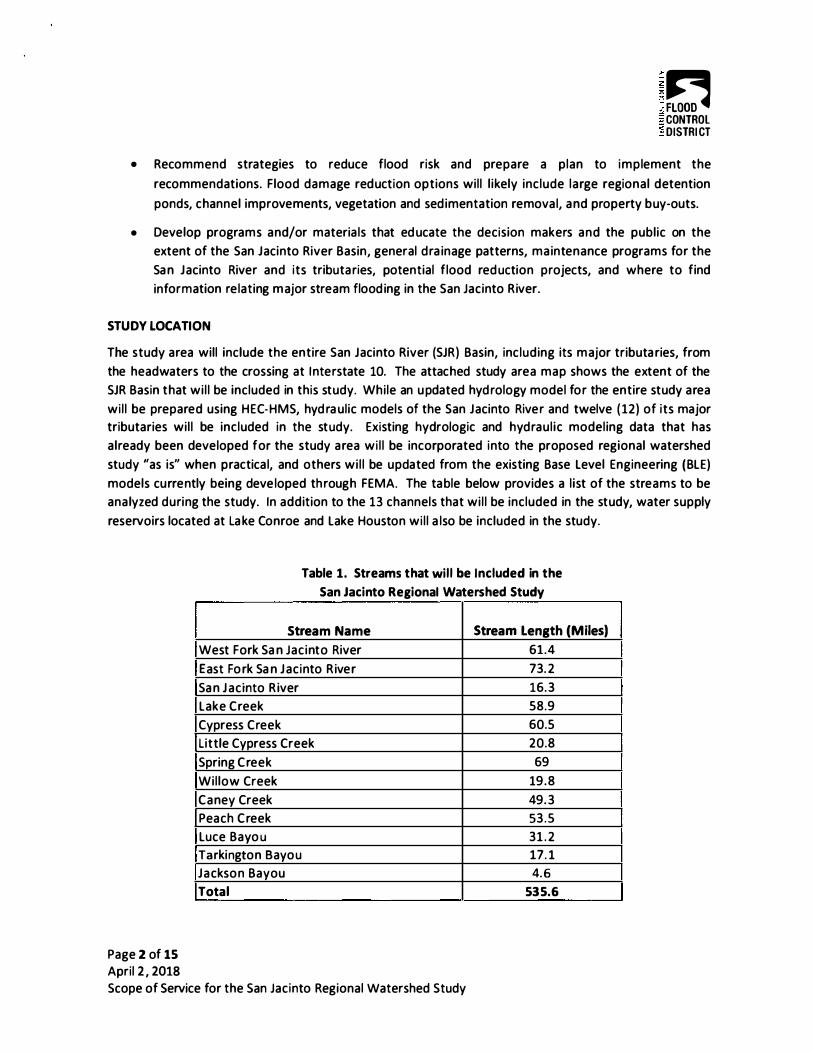
WHEREAS, the Project will improve the flood management capabilities of the Authority and other regional governmental entities, in that the scope of the Project will include, among other things, (i) review of existing studies, plans, modeling, data, and information, (ii) development of additional survey and sedimentation data, (iii) development of updated hydrologic and hydraulic models, (iv) identification and evaluation of flood mitigation measures, (v) suggestions for vegetation and sediment maintenance, (vi) opportunities for expansion of flood warning systems, (vii) flood response planning, (viii) community outreach and education; and
WHEREAS, the Authority wishes to participate with the District and other regional governmental entities in the Project, and to contribute funds towards the Project, if, as and when the Grant Application is approved by T DEM;
NOW THEREFORE, BE IT RESOLVED BY THE BOARD OF DIRECTORS OF THE SAN
JACINTO RIVER AUTHORITY THAT:
Section 1: The Board of Directors of the Authority hereby finds and declares that the Project will be necessary and beneficial to the citizens of the upper San Jacinto River watershed, that the Authority is eligible and willing to participate in the Project, and that the Authority shall contribute funds towards the Project, if, as and when the Grant Application is approved by T DEM, as set forth hereinafter.
Section 2: The Board of Directors authorizes the General Manager to negotiate and enter into one or more agreements with Montgomery County, Harris County and/or HCFCD, and/or the City, to participate in the Project. The Board of Directors further authorizes the General Manager, under such agreement(s), to commit the Authority to contribute up to twenty percent (20%) of the local cost share set forth in the Grant Application and required by the terms and conditions of the TDEM grant, not to exceed a total of $125,000.00.
Section 3: The Board of Directors authorizes the General Manager to amend the Lake Conroe Division annual budget to provide funding for study participation, as required, but subject to the expenditure limit set forth in Section 2 hereof.
Section 4: The Board of Directors authorizes the General Manager to utilize funds from the financial reserves of the Lake Conroe Division to provide funding for study participation, as required, but subject to the expenditure limit set forth in Section 2 hereof.
Section 5: This Resolution is intended to supersede Resolution No. 20 18-R-04, approved and adopted by the Board of Directors on January 25, 20 18. Resolution No. 20 18-R-04 shall be rescinded, and shall be of no further force and effect, immediately upon the approval and adoption of this Resolution.
APPROVED AND ADOPTED by the Board of Directors of the San Jacinto River Authority, at a regular meeting on the 24tl1 day of May, 20 18.
ATTEST:
__ ............ ,, ----o R i v'',, (SEAL) .. --''\ ••••••• • S°-6'' :" ,,� ... ··.'r '
: CJ ... *·.-,:r'• : "'<: : •• c:. •, ,-,• • _. I I • • -1, • • I I -7 • • .::r: I l tt&- • • I 1,a_� : o , ' . . ,
Texas Division of Emergency Management Recovery, Mitigation and Standards
Section 404 Hazard Mitigation Grant Program (HMGP)
Application Introduction, Instruction, and Information
The Hazard Mitigation Grant Program (HMGP) assists states and local communities in implementing long-term hazard mitigation measures following a major disaster. The funding for this program is based on a 75/% federal and 25% local cost share. Further information concerning Texas' involvement in the HMGP can be found in the current Texas Division of Emergency Management (TDEM) Hazard M itigation Grant Administrative Plan.
If you require technical assistance with this appl ication, or to request a copy of the current TDEM Hazard Mitigation Grant Program Administrative Plan please contact Texas Division of Emergency Management, Recovery, Mitigation and Standards (TDEM/RMS), Mitigation Section at (512) 377-0023 or [email protected].
INSTRUCTIONS
The application and attachments can be found on the fo llowing websites:
Please complete ALL sections and provide the documents requested. All questions must be answered completely and accurately. TDEM and the Federal Emergency Management Administration (FEMA) staff reviewing the application will not be familiar with your community, the specific project area , and the need for the proposed project. Therefore, it is the responsibil ity of the applicants to ensure the application addresses all of the questions and requirements. This is particularly important g iven the competitive nature of the grant program. If you are unsure as to the meaning of a particular question, contact TDEM for clarification.
ELIGIBILTY
TOEM, as the grantee, is responsible for ensuring appl icants meet the el igibi l ity requirements and projects are eligible for HMGP funding.
Applicant Eligibility: 1. HMGP projects must be from an elig ible appl icant. ( i .e . , Municipality, City, County, Special District, Tribe, Eligible
Nonprofit Agency, or Organization).
2. Applicant must have an approved hazard mitigation plan. For private non-profit organizations, the community where the project is located must have an adopted plan.
Project Eligibility:
1. Projects cannot be retroactively fu nded through HMGP. Therefore. projects already in progress or completed will not be considered.
2. HMGP projects must comply with the FEMA approved state and applicable local hazard m itigation plan.
3. HMGP projects must meet al l applicable codes and standards for the project locale (i .e., construction, public notifications, etc.) .
4 . HMGP projects must have a direct beneficial impact upon the designated disaster area, whether or not the project is located in the designated area.
5. HMGP projects must comply with 44 Code of Federal Regulations (CFR) part 9, F loodplain Management and Protection of Wetlands and 44 CFR. part 10, Environmental Considerations.
6. HMGP projects must solve a problem independently or constitute a functional portion of a solution where there is assurance that the project as a whole will be completed. Projects that merely identify or analyze hazards or problems are not eligible.
Paqe 1 of 12
Project Eligibility - Continued
7. HMGP projects must be cost effective and substantially reduce the risk of future damage, hardship, loss, or suffering resulting from a major disaster.
8. HMGP projects must provide the best solution. Sub-applicants must demonstrate that after consideration of a range of options for the mitigation measure, it has been determined that the proposed project is the most practical, effective, and environmentally sound solution.
9. HMGP projects must contribute to a long-term solution that is the most practicable. Ideally, i t should integrate hazard mitigation principles with existing programs and overall community planning.
10. HMGP projects must consider long-term effects. Projects should address, when applicable, long-term changes to the areas and entities it protects, and ensure manageable future maintenance and modification requirements.
11. HMGP projects must address a problem that has been repetitive or that possesses a significant risk if left unsolved. 12 . HMGP projects must cost less than the anticipated value of the reduction in both d irect damage and subsequent
negative impacts to the area if future disasters occur.
ATTACHMENTS
Below are the attachments related to this appl ication . You can access the attachments by clicking the paper clip symbol on the left side of the form (see image below).
Homo Tools
Attachment List
1. Budget Worksheet 2. Budget Worksheet Instructions 3. Designation of Subrecipient Agent (DSA) Form (Note: See Grant Management System for additional information below)
4. Environmental Historical Preservation (EHP) Checkl ist 5. FEMA Benefit Cost Analysis (BCA)Toolkit Instructions to Insta ll 6. Property Site Inventory Worksheet (Required for Acquisition, Elevation, and Mitigation Reconstruction projects)
7. Three SF424 Forms (SF424-Application for Federal Assistance, SF424B-Non-Construction Assurances and SF4240-Construction Assurances)
REQUIRED DOCUMENTATION Below is the minimum required documentation that must be submitted with the application. Note: This is not an al l inclusive list since requirements may vary depending on project type and the sub-applicant.
1 . Application (with supporting documents used for additional space or to clarify answers) 2. Map(s), Photo(s), Drawing(s) , etc. as required in the application 3. EHP Checklist 4 . FEMA Insurance Rate Map (FIRM) per the EHP Checklist 5. Supporting Documentation per EHP Checklist 6. Budget Worksheet 7. Property Site Inventory Worksheet (Required for Acquisition, Elevation and Mitigation Reconstruction projects)
8. BCA zip file 9. Certification and Signature of Authorized Agent (page 1 O of the appl ication) 10. Floodplain Manager Authorization Form (page 1 1 of the appl ication) 1 1 . DSA Form 12. All three SF424 forms (SF424, SF424B and SF424D)
GRANT MANAGEMENT SYSTEM (GMS) The D ivision of Emergency Management uses the GMS on-l ine system to manage the HMGP and other FEMA grant programs. For more information and to register for access please visit https://grants.dps.texas.gov/index.cfm.
Note: The DSA Form provides the information needed to set up the contact information in the system.
���T�p�-----------------------------------------------------------------------. 'la� Texas Division of Emergency Management 1 .. :1 \,�!! 1�1 ... Recovery, Mitigation and Standards
�����·======================::::::::::::::::::::::::::::::::::::::::::::::::::::::::::::::::::::::::::::::::::::::::::::::I � Section 404 Hazard Mitigation Grant Program (HMGP)
Application Form
Disaster Declaration#: FEMA-4332-DR-TX Declaration Date: August 25, 2017
SUB-APPLICANT INFORMATION
Name of Sub-applicant Organization/Agency: _H_a_rr_is_C_o_u_n_.ty_F_lo_o_d_C_o_n_tr_o_I _D_i s_tr_ic_t ------------
State Legislative House District(s): 3, 15, 16, 18, 23, 127 State Legislative Senate District(s): 3, 4, 6, 11, 15
Congressional House District(s): 2, 8, 18, 29, 36
National Flood Insurance Program (NFIP) Community Identification #: 480296, 480297, 480287 (This number can be obtained from the FIRM map for your area)
NFIP Community Rating System Class # (if available): _4_8_02_ 9_6 __________________ _
PROJECT INFORMATION
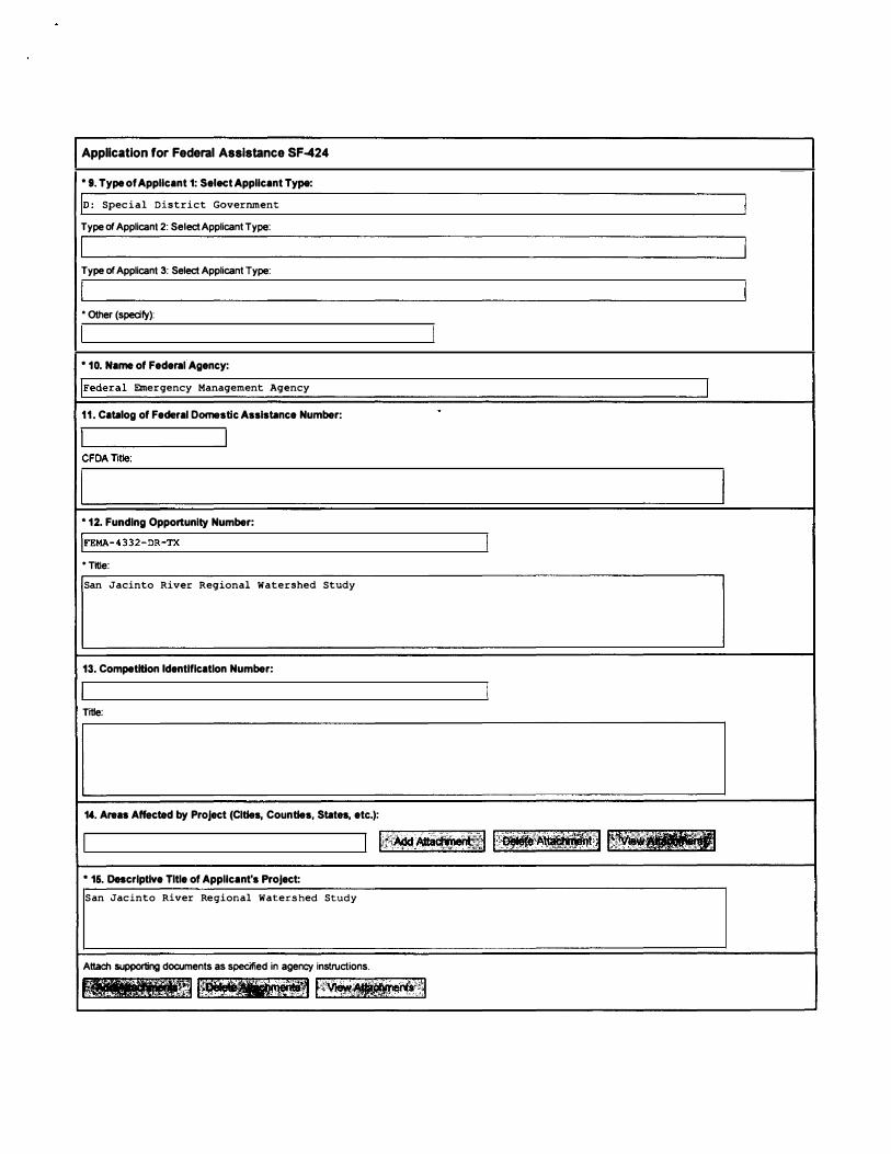
Project Title: San Jacinto River Regional Watershed Study
Application Type: (select from the following)
D Standard HMGP [ll 5% Initiative D Planning D Phased Project
Project Type: (select from the following) 0 Acquisition D Elevation 0 Residential Saferoom 0 Drainage D Generator D Wildfire 0 Other: ____________ _
Hazards to be Mitigated: (select from the following)
D Community Saferoom D Structural Retrofit
Ill Flood D Wind O Wildfire 0 Subsidence D Storm Surge
0 Other: ____________ _
Note A Property Site Inventory Worksheet (see attached) ts reqwred for Acaws1tion Elevation. and Mitigation Reconstruction projects)
PaJe 3of12
SCOPE OF WORK Project Description: Description must include: what hazard(s) the project will address, type of project (drainage, safe room, fuel reduction, buyout, etc., and/or infrastructure), step by step description of the major elements of the project (contracting, construction elements, close-out, etc.), and how the project will be accomplished by the end of the 36 month oeriod of oerformance (PoPJ. Attach extra pages as necessary.
The proposed regional study of the San Jacinto River watershed will address flooding and the response to flooding in the San Jacinto River watershed. The watershed covers portions of Harris, Montgomery, Liberty, San Jacinto, Walker, Grimes and Waller counties in eastern Texas, and includes more than 13 major streams including the San Jacinto River, that span more than 500 stream miles. The study area also includes two water supply reservoirs, one at Lake Conroe and one at Lake Houston. The Harris County Flood Control District (HCFCD) will serve as the lead agency for the study. It is anticipated that the San Jacinto River Authority, Montgomery County, and the City of Houston will partner with the HCFCD to conduct the study. Major components of the study include:
Task 1: Project Management, Coordination and Document Control - Extensive coordination with multiple study partners and stakeholders will be required through projects meetings, written and verbal correspondence and status reports.
Task 2: Review and assess existing data, obtain additional data as needed - Gather, receive, review and analyze existing studies, plans, models GIS data, gage information for the study area, as well as sedimentation data for the San Jacinto River. Perform field visits in addition to desktop assessments and review of gathered data. Obtain additional survey data as needed.
Task 3: Existing Conditions Hydrologic and Hydraulic Model Development - develop existing condition hydrologic and hydraulic models that will be used to identify flood risk along the San Jacinto River and its major tributaries.
Task 4: Analyze Historical Storm Events and Calibrate Models - Calibration will be performed for the existing condition models developed in Task 3 utilizing precipitation data, gauge records, high water mark data, flood records, and other information based on historical storm events.
Task 5: Future Conditions Hydrologic and Hydraulic Models - Update the existing conditions models developed in Task 3 to simulate future conditions within the watershed if no new flood mitigation measures are implemented. Future conditions will be estimated using population growth projections, regional growth/development patterns, drainage criteria adopted by regulatory agencies within the study area, and other available data.
Task 6: Flood Mitigation Planning - Identify feasible flood mitigation measures to reduce flood risks within the San Jacinto River watershed. Flood mitigation measures will likely include recommendations for detention, channel conveyance improvements, and buyouts. When selecting the most feasible alternatives, consideration for right-of-way acquisition, cost effectiveness, constructability, environmental constraints, design life, and public benefit will be considered along with other factors. Flood mitigation effectiveness, right-of-way requirements, environmental constraints, utility conflicts, other possible challenges that would impact implementation will be identified as part Task 6.
Task 7: Vegetation and Sediment Control Plan - Coordinate with appropriate agencies and to discuss previous vegetation and/or sedimentation evaluations. Research, collect, and review necessary information to develop a maintenance plan to help address sedimentation and vegetative growth along the West Fork of the San Jacinto River.
Task 8: Flood Warning System - Coordinate with appropriate agencies to discuss expanding the Harris County Flood Warning System gauge locations in the San Jacinto River watershed and identify locations where additional gauges would be beneficial, and document the steps that must be taken to ensure the gauges can be installed.
Task 9: Flood Response Planning - Meet with appropriate agencies responsible for flood response within the study area and discuss existing plans and protocols, and identify potential measures that could be used to improve flood response activities. With input from the responsible agencies, an updated communications plan will be developed to facilitate sharing information between agencies and with the public.
Task 10: Community Outreach and Education - Develop educational materials suitable to convey information to the public about the study purpose, findings, recommendations and conclusions.
PJg2 4 of 12
Project Objectives - Problem Solutions/Hazard Reduction: Description must include: how the project will independently solve the problem, the level of protection provided by the project, how the project will increase the level of protection to the citizens and/or properties, the number of people and properties that will directly benefit from the project, and how the project will ultimately reduce the costs associated with recovery from future disasters. Attach extra pages as necessary.
The proposed study will address flood risk throughout the San Jacinto River watershed in several ways:
* The study will develop a comprehensive set of models for the San Jacinto River and its major tributaries using consistent. cohesive methodology regardless of the county in which those channel are located. This information can be used to establish the existing flood risks along the studied streams and develop important information for communities within the study are to utilize for hazard mitigation planning purposes, as well as planning for future growth within the study area. Information to be developed includes inundation maps for the studied streams that show the extent and depth of riverine floodplains for an array of storm events to be simulated. Additionally, information will be gathered about the number of structures, acres of land, parcels, and miles of roadway are located within the modeled floodplains.
* The study will evaluate flood mitigation measures to address the flood risks that are identified during the study. For each flood mitigation measure that is identified, an implementation plan will be developed that provides information regarding the order in which projects should be pursued, the amount of additional right-of-way needed to complete the project, critical constraints such as utility or environmental conflicts, and general cost estimates. This information will help communities within the San Jacinto River watershed understand the major components for the recommended mitigation measures so that the necessary planning to complete the projects can be performed.
*The San Jacinto River watershed spans multiple counties, and multiple jurisdictions, and includes numerous large streams, as well as two water supply reservoirs. Due to the large size of the contributing drainage area, when the San Jacinto River floods, the water can remain at flood stages for prolonged periods and impact the numerous communities along the river. It is essential that emergency responders within the San Jacinto River watershed are able to coordinate with each other and share information in a consistent, constructive manner. As part of the proposed study, a communications protocol and action plan will be developed. This plan should help facilitate a consistent approach across all agencies to locate and protect critical facilities, deploy emergency services, and communicate evacuation routes and shelters to the public.
Project Objectives - Outcome, Level of Effort and Milestones: Description must include: major milestones for the project (contracting complete, final engineering/design complete, mobilization for construction, construction phase(s), activities associated with these steps, percentage of total project budget or dollar amounts associated with these steps. Attach extra pages as necessary.
The major tasks, and associated percentage of the total project budget, is as follows:
1. Project management - 5% of the budget 2. Data collection --- 10% of the budget 3. Existing condition model development - 20% of the budget 4. Historical storm simulation and calibration --- 6% of the budget 5. Future conditions without flood mitigation measures model development --- 5% of the budget 6. Flood warning system-- 12% of the budget 7. Flood response planning -- 20% of the budget 8. Flood mitigation planning --- 17% of the budget 9. Community outreach and education -- 4% of the budget 10. Preparation of final deliverables -- 1 % of the budget
Page 5 of 12
Milestones/Tlmeline: List the major milestones (e.g. designing, engineering, permitting, etc.) for the project by providing an estimated timeline for the critical activities not to exceed a 36 months. These milestones should correspond with the Project Objective description above and budget. For the Starting Month column below, please enter the month (1 through 24) you will begin this milestone once once you receive your award (i.e. Month 1 would be the same month as your performance period start date, Month 36 is the last month of your performance period.) For the Mos. to Complete column, please enter the number of months it will take to complete the milestone. (See examples below)
1. 2. 3. 4. 5. 6. 7. 8. 9. 10.
Miiestone
Project Management and Coordination
Data Collection and Review
Existing Conditions Model Development
Model Calibration
Future Condition without Flood Mitigation Measures Model Development
Flood Warning System
Flood Response Planning
Flood Mitigation Planning
Community Outreach and Education
Final Deliverable
Starting Est Mos. to Month Complete
Month 1 18 months
Month 1 2 1/2 months
Month 3 3 months
Month 6 3 months
Month 9 1 1/2 month
Month 4 3 months
Month 6 6 months
Month 11 4 1/2 months
Month 3 15 months
Month 14 4 months
Project Objectives - Project Staff and Management: Description must include: how the sub-applicant will organize and manage the project to ensure successful completion within the project period of perfonnance, a brief description of all staff associated with the project by position and what their role and responsibilities are for completing the project within the period of perfonnance. Attach extra pages as necessary.
The HCFCD will be supported by a team of consultants in order to complete the study. To ensure that high quality of work is performed, and that the study is completed on time, close coordination with the consultants working on the study, as well as with the other study partners (City of Houston, Montgomery County, San Jacinto River Authority) will be conducted. A project manager from the HCFCD will be assigned to work on the study and help support the consultant team. At a minimum. weekly conference calls between the HCFCD project manager and the project manager representing the consultants will be conducted. Monthly progress meetings will be conducted in person - at the progress meetings the consultants will provide an overview of the work that was accomplished since the previous progress meeting, and discuss what they will be working on over the next month. Additionally, briefings with executive management at HCFCD and the other study partners will be conducted during milestones in the study progress.
In addition assigning a dedicated project manager from HCFCD staff to assist with the study, the following staff will also participate:
Matt Zeve, Director of Operations. Matt will provide high level guidance to HCFCD staff and consultants carrying out the study. He will serve as the point of contact for the participating agencies (SJRA, COH, Montgomery County, etc.). He will make resources available and re-prioritize other work efforts in order to keep the study on schedule.
Dena Green, Feasibility Studies Department Manager. Dena will provide guidance and oversight for the study in general throughout the study process, and provide assistance for the project manager when needed.
Jonathan Holley, Regulatory Compliance Department Manager. Jonathan Holley will provide guidance and insight related to environmental regulatory compliance for flood mitigation measures identified during the study.
Damage History - Overview of Past Damage: Provide a detailed past history of damages in the project area including approximate costs. Include information for Presidential or Federal level disasters as well as State or local level declarations. Attach any supporting documents. Costs should include damages to structures and infrastructure in the project area as a result of the hazard. Additional costs should include the cost to the local government to respond to victims of the hazard in the project area, any interruption to local businesses, losses of public services, and costs for temporary housing of the affected population, etc. This section helps demonstrate the need for the project.
Note: Acquisition, Relocation, Elevation, or Demolition Project: Complete a listing of specific damages to each property on a separate spreadsheet and include as an attachment.
Date Level of Event Type or Extent of Damage Total Cost of Damage 06/05/01 Tropical Storm Allison 2,881 structures (Harris Cnty)
1 0/15/94 October 1994 Flood 1 ,381 (Harris County)
05/25/15 Memorial Day Flood - 500 year flooding event 6 structures (Harris County)
10/31/1 5 Halloween Day Flood - 400 year event 1 structure (Harris County)
04/17/16 Tax Day Flood - 600 year event 16 structures (Harris County)
05/28/16 Memorial Day Flood - 700 year event 48 structures (Harris County)
Historical flooding in Montgomery County To be researched with study
Historical flooding throughout the study area To be researched with study
Project Location: Fully describe the location of the proposed project. Describe the area and/or population affected or protected by this project. Include the location if possible (street address with numbers or neighborhood, city, county with zip codes, Lot, Block or Survey). Provide GPS reading (Lat/Long) of the project site in degrees decimal minutes to 5 places if possible (i.e.: 30.326958 / -97.724750). Attach a separate spreadsheet for multiple latitude/longitude coordinates and descriptions as needed.
Latitude: 29 44' 56.59" Longitude: 95 17' 24.01 "
Description:
The proposed project area is the San Jacinto River watershed, from its headwaters down to its crossing at Interstate 1 0. The watershed covers portions of Harris, Montgomery, Liberty, San Jacinto, Walker, Grimes and Waller counties in eastern Texas, and includes more than 12 major streams, in addition to the San Jacinto River, that span more than 500 stream miles. The project area also includes two water supply reservoirs, one at Lake Conroe and one at Lake Houston.
Population and Structures Affected by Project: Indicate the approximate number of people affected by this project to include residents, customers, commuters, or visitors, etc. Provide the number of each type of structure (listed below) in the project area. Include all structures directly affected in project area.
500,000! Number of people affected ';===:::!!;-! Number of residential properties
:===�Number of businesses I commercial properties
�==�Number of public buildings
::===�Number of schools
::====-Number of hospitals I medical clinics 8,000! Other (List): learcels with structures on them (within Harris County only)
F'aJc ; of 12
MAPS
Two maps must be provided with your application. One must show the general location of the project site and the other must show the specific project site. In certain cases when there are no maps available, substitute with an overview photo, drawing or sketch. Ensure it is legible, shows magnetic north, and has major landmarks noted for orientation.
Map Depicting Project Site: (check the boxes to indicate what type of maps are attached)
[Z] City, County, or District scale map showing the entire project area with the project site and structures marked on the map.
D USGS 1 :24 ,000 topographical map with project site marked on the map.(Map depicting relationship to existing features - natural and otherwise)
For acquisition or elevation projects, include a copy of the Parcel Map (Tax Map, Property Identification Map, etc). with each property in the project clearly marked on the map. Use SAME ID number as in the Property Site Inventory Worksheet.
NOTE: On one or both of the maps and depending on the type of project, you may depict multiple requirements that are listed below, instead of a separate map for each.
These help clarify the project setting and the potential impacts of the project on the environment (soils, vegetation, hydrology, wildlife) and they assist in understanding the written description of the project, especially if contours and elevations are provided. The photographs should be representative of the project area, including any relevant streams, creeks, rivers, drainage areas, etc; which affect the project site or will be affected by the project. If photos are provided, then FEMA may not need to conduct a site visit, thereby, reducing the review time. Include ALL engineering calculations and quantity determinations for this project. These are in addition to any map substitutions. Please check the box below for the items you are attaching to your applicaiton, if any:
D Photographs
D Sketches/Drawings
D Engineering Designs (including calculation and quantity determinations)
D Other
ENVIRONMENTAL HISTORICAL PRESERVATION (EHPJ COMPLIANCE Please complete the EHP Checklist (see attachment} and include in the application submission.
As a Federal agency, the Department of Homeland Security (OHS) I Federal Emergency Management Agency (FEMA} is required to consider the effects of its actions on the environment and/or historic properties to ensure that all activities and programs funded by the agency, including grants-funded projects, comply with Federal EHP regulations, laws, and Executive Orders, as applicable. Grant recipients proposing projects that have the potential to impact the environment, including but not limited to construction of communication towers, modification or renovation of existing buildings, structures and facilities (including installation of equipment), or new construction including replacement of facilities, must participate in the DHS/FEMA EHP review process. More information about the EHP requirement can be found at the following links:
Maps will also be required for this portion of the application. If you have photos, sketches, drawings, engineer designs, etc. that will help clarify the project location and structures, please be sure to include them with your application.
BUDGET INFORMATION Please complete the Budget Worksheet attachment by following the attached "Budget Worksheet Instructions". You can access the attachment by clicking on the paper clip on the left side of the form.
Once the budget has been completed, provide the following information from the worksheet:
(Note Enter numbers only (no $or comma 'sl as tt1e f1elcfs 1s automatically formatecl)
Total Project Costs: $ 2,500,000.00
Applicants Cost Share: $ 625,000.00
Federal Amount: $ 1,875,000.00
Reminder: Applicant must include the Budget Worksheet when submitting the application
BENEFIT COST ANAL YS/S Applicants must demonstrate mitigation projects are cost effective. The Benefit Cost Tool Version 5.3 is used to perform benefit cost analysis for applications submitted under FEMA's Hazard Mitigation Assistance Grant Programs. To use this tool, you must first download the file from the website (see link below). If you have any questions about the new BCA software program, please contact the BC Helpline at [email protected] or at 1-855-540-6744.
https ://www.fema. gov/med ia-1 i brary /assets/documents/ 1283 34
Once the SCA has been completed, provide following information from the BCA:
(Note Enter numbers only (no$ or comma s) as the fields rs automatrcally formated)
Total Project Cost:
Total Value of Project Benefits:
Benefit Cost Ratio:
Reminder: Applicant must include a zip file of the BCA when submitting the application
BCA Exceptions
• Acquisition Projects - The acquisition of structures that are declared Substantially Damaged (from any origin) and located in a riverine Special Flood Hazard Area (SFHA) on a preliminary or effective FIRM is considered cost effective.
• Residential Safe Room Projects - The pre-calculated benefit provides standardized Benefit-Cost Analysis (BCA) benefit values associated with residential safe rooms so that individual BCAs are not required, as long as the project costs do not exceed $5,421.32 (in Texas).
• Acquisition and Elevation Projects - The national average for benefits for acquisition and elevation projects is $276,000 for acquisition projects and $175,000 for elevation projects. FEMA determined the acquisition or elevation of a structure located in the 1 00-year floodplain for which costs are equal to or less than the amount of benefits noted above is cost effective. For projects that contain multiple structures, the average cost of all structures in the project must meet this criterion. There is no need for recipients to conduct a separate BCA for a structure that meets this criterion.
• A wind retrofit project is considered cost effective as long as the total project costs are less than the costs listed below:
CERTIFICATION AND SIGNATURE OF AUTHORIZED AGENT FORM
The Chief Elected Official Ourisdiction) or Executive Director (non-jursidiction) must certify the following statements before the project listed below will be considered for Hazard Mitigation Grant Program (HMGP) funding.
Name of Sub-Applicant (jurisdiction/non-jurisdiction) Identified in the Application: (auto-populated from the first page of the application)
!Harris County Flood Control District
Project Titles Identified in the Application: (auto-populated from the first page of the application)
jsan Jacinto River Regional Watershed Study
To certify, please check the boxes and sign below:
It/ I The undersigned will ensure all State and Federal requirements related to the HMGP funding are fulfilled.
It/ I The undersigned understands that the jurisdiction/non-jursdiction applying for this grant is liable for the required matching funds (local share) related to the project listed above.
It/ I The undersigned has reviewed and approved the project and information contained in the application.
In August 2017, H urricane Harvey struck the Texas coast, bringing a historic amount of ra infa l l to the
Houston region. The storm produced never-before-seen precipitation depths in Harris and Montgomery
Count ies, as wel l as severa l surround ing counties. As was the case with most of the watersheds in the
region, the San Jac into River basin experienced widespread flooding, which resulted in significant
damage. In the wake of the storm, the Harris County Flood Control District (HCFCD), San Jacinto River
Authority (SJRA), Montgomery County (MCO), and City of Houston (COH) recognized that steps needed
to improve coord ination, communication, and response among the responsible agencies along the San
Jacinto River during major flood ing events. In add it ion, a comprehensive plan of i m provements a imed
at reducing flood risk in the basin was a lso recognized as a key piece of the overal l recovery p lan. The
scope provided below is intended to be the first step in addressing each of these e lements for the San
Jacinto River Basin .
GOALS AND OBJECTIVES
The overa l l goa l of the San Jac into River Regiona l Watershed Study is to:
Perform a hydrologic and hydraulic analysis of the San Jacinto River Basin's major streams during
extreme rainfall events, develop approaches to enhance the flood warning and flood response
planning capabilities during a disaster, and evaluate flood mitigation strategies that can be
implemented both near-term and over the long-term to reduce the flood risk to people and property.
As such, the study specific objectives include the fo l lowing:
• Coord inate with flood responders including Harris County Office of Emergency Management
(OEM), Montgomery County OEM, SJRA, City of Houston, and potentia l ly others, such as the
Harris County Flood Contro l District's Hydrologic Operations Depa rtment, to develop a
consistent com munications protocol and action plan. This p lan should help faci l itate a
consistent approach across a l l agencies to locate and protect critica l fac i l ities, deploy emergency
services, and communicate evacuation routes and shelters to the pub l ic.
• Work with HCFCD, SJRA, MCO, and COH to develop strategy to gather and shared flood warning
information that can be ut i l ized by a l l parties to make informed decisions. This strategy wi l l a lso
include recommendations for add ing to the existing Harris County Flood Warning System gage
network and recommendations for addit ion additiona l gages at recommended locations
throughout the San Jacinto River Basin.
Page 1 of 1 5 April 2, 2018
Scope of Service for the San Jacinto Regional Watershed Study
E� CONTROL DISTRI CT
• Recommend strategies to reduce flood risk and prepare a p lan to imp lement the
recommendations. F lood damage reduction options wi l l l ikely inc lude large regional detention
ponds, channel improvements, vegetation and sed imentation remova l, and property buy-outs.
• Develop programs and/or materia ls that ed ucate the decision makers and the publ ic on the
extent of the San Jacinto River Basin, general d ra inage patterns, ma intenance programs for the
Sa n Jacinto River and its tributa ries, potential f lood red uction projects, and where to find
information re lating major stream flood ing in the San Jacinto R iver.
STUDY LOCATION
The study area wil l include the entire San Jacinto River (SJR) Basin, inc lud ing its major tributa ries, from
the headwaters to the crossing at Interstate 10. The attached study area map shows the extent of the
SJR Basin that wi l l be included in this study. Whi le an updated hyd rology model fo r the entire study area
wi l l be prepared using HEC-HMS, hyd ra ul ic models of the San Jacinto Rive r and twelve ( 12) of its major
tributaries wi l l be inc luded in the study. Existing hydrologic and hydrau l ic model ing data that has
a l ready been developed for the study area wi l l be incorporated into the proposed regional watershed
study "as is" when practica l, and others wi l l be updated from the existing Base Level Engineering (BLE)
models currently being deve loped th rough FEMA. The table below provides a l ist of the streams to be
ana lyzed during the study. In add ition to the 13 channels that wi l l be inc luded in the study, water supply
reservoirs located at La ke Conroe and Lake Houston wi l l a lso be included in the study.
Page 2of 15 Apri l 2, 2018
Table 1 . Streams that wil l be Included in the
San Jacinto Regional Watershed Study
Stream Name Stream Length (Miles) West Fork Sa n Jac into River 61 .4
East Fo rk Sa n Jac into R iver 73. 2
Sa n Jacinto R iver 16.3
Lake Creek 58.9
Cypress Creek 60.5
Little Cypress Creek 20 .8
Spring C reek 69
Wi l low Creek 19.8
Caney Creek 49.3
Peach C reek 53.5
Luce Bayo u 31.2
Tarkington Bayou 17.1
Jackson Bayou 4.6
Total 535.6
Scope of Service for the San Jac into Regional Watershed Study
STUDY PARTNERS
f j CONTROL DISTRICT
There are severa l partners that wi l l contribute to the study in a variety of ways. The primary fund ing
partners are anticipated to be:
• Harris County Flood Control District (Lead Agency)
• Montgomery County
• San Jacinto River Authority
• City of Houston
Other potential partners may provide support during the grant study process. These partners may
include:
• Texas Department of Transportation (TXDOT)
• City of Conroe
• Woodlands Township
• The community of Kingwood
• Liberty County ( Luce Bayou)
• San Jacinto County (East Fork SJR)
• Walker County (Upper West Fork SJR)
• Un ited States Geological Survey (USGS)
• Nationa l Weather Service (NWS) River Fo recast Center (RFC)
• Other communities i n the study watershed
Page 3 of 15 April 2, 2018 Scope of Service for the San Jacinto Regiona l Watershed Study
SCOPE OF SERVICES
I. PROJECT MANAGEMENT AND COORDI NATION
fooo1 CONTROL D ISTR ICT
A. Project Management and Admin istration - Based on ari estimated schedule of 12 - 18
months, the Project Manager wi l l be responsible for project management and coordination
services consisting of interna l team management and subconsultant management, as wel l as
regular communication with the Harris County Flood Control D istrict {HCFCD) and the other
study partners. Specific tasks include:
1. Interna l project management includ ing task leadership, interna l communication, and
data management as specified in the Project Management Plan (PM P).
2 . Subconsultant management and coord ination includ ing contracting, invoicing, review of
de l ivera bles, and commun ication .
3. Admin istration of the contract, inc lud ing preparation of invoices and progress reports
on monthly basis and requests for a uthorization as needed . Authorizations wi l l be
based on the scope of services and justification wi l l be provided as needed.
4. Provide a project schedule ind icating tasks, critica l dates, and de l iverab les, and prepare
regular updates.
B. Study Kickoff Meeting - Attend the in itia l study kickoff meeting to d iscuss study goa ls and
objectives, review the project schedu le, and d iscuss de l iverab les and other relevant items.
Meeting wi l l be attended by the Project Manager and a Project Engineer at a min imum.
C . Weekly Conference Calls -Participate in weekly coord ination ca l l s with HCFCD.
D. Monthly Project Coord ination Meetings - Prepare for and attend a monthly project progress
meeting with the project team (18 meetings) . This includes preparation of the meeting
agenda and any necessary meeting materia ls (maps, documents, etc.). Minutes
documenting the discussion will be provided summarizing the d iscussion and action items.
Al l meetings wi l l be attended by the Project Ma nager and one {1) add it ional team member
at a m in imum.
E . HCFCD Executive Briefings - Prepare for and attend up to two ( 2) executive briefings for
HCFCD. The a ppropriate time for these briefings wi l l be determ ined by the project team .
1 . Attend two ( 2 ) Executive Briefings t o present study findings (to date) as we l l as the steps
moving forward.
2 . Prepa re a PowerPoint presentation a s well a s necessa ry exh ib its fo r the meetings. Draft
versions of both the presentations and materia ls wi l l be provided to HCFCD for review
and comments. Make adjustments to the materials based on comments.
3. Participate in up to two (2) pre-meetings for each Execut ive Briefing. These meetings
a re intended to d iscuss the presentation and exhibit content as we l l as to vet the study
findings to be presented .
Page 4 of 15
April 2, 2018 Scope of Service for the San Jacinto Regional Watershed Study
Foo� CONTROL DISTRICT
F. Sa n Jacinto River Authority (SJRA), City of Houston (COH) and Montgomery County (MCO)
Briefings - Prepare for and present at up to two additional meetings for SJRA, COH and MCO
in addition to the HCFCD executive briefings. These meetings wi l l sha re the same
information as the HCFCD executive briefings a nd should be conducted after the HCFCD
meetings have been held.
G . Coord ination Meetings with Supporting Partners - Attend up to five (S) meetings with
supporting partners as l isted in the STUDY PARTN ERS section on Page 2 of th is scope.
Provide general information re lating to the study. Materia ls to be provided wi l l be at the
d iscretion of HCFCD but it is assumed they would not vary significantly from the materials
developed for the Executive Briefings or SJRA/MCO/COH meetings.
I I . DATA COLLECTION AND REVIEW
A. Data Col lection - Collect relevant items to be reviewed and uti l ized in the study. Data
inc ludes, but is not l im ited to, exist ing stud ies, plans, models, G IS data, gage information,
etc.
• Terra i n I nformation (Updated Li DAR, avai lab le survey data, l imited fie ld survey including
bridges and cu lverts)
• Gage Information (HCFWS, USGS, SJ RA, MC Gages, etc.) to inc lude ra infa l l, WSE L, and
Discharge ( if appl icable)
• Historical H igh-Water Marks (HWM)
• Exist ing Hydrologic and Hydrau l ic models for San Jacinto River and tributa ries wi l l a lso
be gathered. Models and Sources for this information may include:
o HCFCD M3 Models for the Sa n Jacinto River, Spring Creek, Wi l low Creek, Cypress
Creek, Little Cypress Creek, Luce Bayou, and Jackson Bayou
o SJRA Models for the dra i nage area upstream of Lake Conroe, as well as a HEC
RAS dam breach model of the West Fork San Jaci nto River downstream of Lake
Conroe.
o Base Leve l Engineering (BLE) FEMA Models for East Fork San Jacinto, Peach
Creek, and Caney Creek (Bridges may need to be added to these mode ls)
o Avai lab le FEMA Effective mode ls including Lake Creek and others
• Precipitation Data - Multi-sensor Prec ipitation Estimate (M PE) ra infa l l from the NWS for
Hurricane Harvey, TS All ison, 2016 storm, and historica l ra infa l l information for October
1994 from ava i lab le gages
• H istorica l flood complaints that can be provided by the study partners • Sedimentation data and reports for the SJR Watershed
• Ava i lable reports deta i l ing previous model development efforts and m itigat ion planning.
Page 5 of 15 April 2, 2018 Scope of Service for the San Jacinto Regional Watershed Study
Fu.� CONTROL DISTR I CT
• Existing flood response communication protocols from Harris County, Montgomery
County, City of Houston, CWA, and SJRA.
B. Field Reconna issance Visits -Conduct site visits along each of the major streams at to
fami l iarize the project team with the cond itions. These site visits wi l l focus on viewing the
channel at major roadway crossings to view the conditions at the crossing as well as the
channel conditions upstream and downstrea m. Visits to Lake Conroe a nd Lake Houston wi l l
a l so be inc luded to verify the dam configuration is consistent with the model ing. Site visits
will be documented in a field observation report that includes photographs and notes
deta i l ing our find ings.
C. Model Eva luation and Data Review -Review the col lected data and leverage the information
provided for model updates, potentia l flood reduction project recommendations, identifying
locations for potent ia l flood gages, updating flood response protoco ls, and d eveloping
educational materials. Specific tasks include the fol lowing:
1. Review a l l reports provided and determine additional data needs.
2 . Evaluate gage information fo r completeness a n d period o f record as wel l a s comparison
to the h istorical HWM and flood complaint information to determ ine consistency.
3. Evaluate avai la ble H&H models to determine addit ional model construction needs.
4. Evaluate avai lab le terra in information for modeling and mapping purposes.
5 . Provide a comprehensive summary of the review of ava i lab le reports and data.
D. F ie ld Survey Data (as needed) -Determine the locations needed for field survey based on
the data col lected in previous tasks. Survey may inc lude h igh water marks after storm
events, up to (25} stream crossings and up to (15} channel cross sections.
E . Task Del iverables
1 . Catalog of Data Col lected includ ing name, date, and source of information
2 . Field O bservation Reports for site visits
3. Comprehensive Summary of reports and data
4. Field survey text files and fie ld notes
I l l . EXISTING CONDITIONS H&H MODEL DEVELOPMENT
A. Hydrologic Model ing -Update the ava i lable hydrologic model ing to provide an improved
base l ine condition and verify calcu lated flows for frequency storms. The avai lab le HEC-HMS
model wil l be updated to incorporate al l the stream watersheds into a si ngle, cons istent
model . The model wi l l be updated to uti l ize consistent p recipitation, loss parameters, and
hydrograph transform pa rameters. Existing detailed H EC-HMS models provided by HCFCD
wi l l not be updated. Specific tasks inc lude:
1. Hydrologic Model for Steady Ana lysis -Prepare a compre hensive hydrologic model to be
ut i l ized in conjunction with unsteady HEC-RAS model ing.
Page 6 of 15
April 2, 2018
a . Convert existing HEC-HMS model to the most current version (v. 4.2 . 1 or later)
b. Confirm and/or update reserv9ir info rmation fo r Lake Conroe and Lake Houston
Scope of Service for the San Jacinto Regional Watershed Study
--� z
�FLOOD � CONTROL � DI STRICT
c. Subdivide o r combine d ra inage areas to ensure adequate computationa l points and
consistency with the existing gage network. Dra inage a reas for HCFCD models wi l l
not be a ltered . Drainage a reas for other a reas wi l l be del ineated such that major
changes in discharges are captured at tributa ry confluence as wel l as significant
hydrologic features such as b ridges, culverts, detention basins, major outfa l ls, a nd
other features. Future potentia l gage locations wi l l a lso be considered as break
points for the d rainage a rea del ineation .
d . Develop hydrologic toss and transform parameters using a consistent methodology.
The new hydro logy wi l l uti l ize the I n itia l and Constant loss method and the Clark UH
transform method. Hydrologic parameters for HCFCD models (Spring, Cypress,
Luce, Jackson) wi l l not be altered and wi l l maintain the HCFCD specific para meters.
e . Update or develop hydrotogic loss ( I n itial & Constant) and tra nsform (Clark UH)
parameters fo r the watershed using appropriate hydrologic methodology.
f. If needed, develop storage routing using avai lab le hydrau l ic models ( uti l ize
Muskingum-Cunge in a reas where no HEC-RAS model ing exists). Unsteady state
HEC-RAS will be util ized for the study and it is a nticipated that hydrographs
generated in HEC-HMS wilt be routed with the unsteady state HEC-RAS model .
However, certa in instances may arise when some routing wi l l be requ ired in H EC
H MS. Hydra ul ic models wi l l be d iscussed in subsequent sections.
g. Update, if appropriate, the HEC-HMS model to include a ny regiona l detention
ponds, d iversions, or other flood control structure that is not in the current model .
h. Execute model for a range of storms including the 2-, 5-, 10-, 25-, SO-, 100-, a nd 500-
year storm and review/compare the data to the effective model ing (where
ava i lable)
B . Hydraul ic Model ing -Update the avai lab le hyd rau lic (HEC-RAS) models to reflect the desired
level of deta i l . The models are intended to be used for p lann ing purposes and will not meet
standards, specifica lly with respect to survey of cross sections and hydra u lic structures, for a
FEMA Letter of Map Revision (LOMR) or Physica l Map Revision (PMR) . However, they wil l
provide sufficient information to identify flood risks along the streams inc luded in the study,
and to develop inundation data sufficient for local communities to uti l ize when updating
their Hazard Mitigation Plans, as wel l as information that can be uti l ized for communities in
the study area to refer to when plann ing for future capita l projects or the location of critical
facil ities. Models wi l l be developed or updated using multiple sources including: existing
effective steady state models, base level engineeri ng (BLE) models, and existing planning
level unsteady model ing. Existing model ing wil t be leveraged as m uch as is deemed
appropriate . Table 1 shows the streams to be stud ied.
1. Unsteady State Hyd ra u l ic Analysis - Develop unsteady state model ing for the tributa ries
l isted in Tab lel .
Page 7 of lS
April 2, 2018
a. Convert a l l HEC-RAS models to the most current version (v 5 .0 .3 or later)
b . Update H EC- RAS models to reflect most current terra in data and fie ld survey
Scope of Service for the San Jacinto Regional Watershed Study
Foo� CONTROL DISTRICT
i. Adjust cross section a l ignments and update elevations from the terra in data.
The hydrau l ic models wi l l be updated using the most recent terra in with the
exception of the effective HCFCD mode ls, which will not be a ltered
i i . Add bridge and cu lvert crossings as needed to the HEC-RAS models. These wil l
be based on field survey data where it is ava i lable or field observation and
measurements i f survey data is unava i l able.
c. Review and update model parameters, includ ing roughness val ues, obstructions, and
ineffective flow areas, as needed based on site visits and/or aerial imagery.
d . Update flow data and apply inflow hydrogra phs. Consideration for flow change
locat ions wi l l include (at a min imum) roadway crossings where there a re currently gages
or future potential gage locations, confluences of tributa ries, or other locations where
there are sign ificant changes in stormwater d ischarge when inflow hydrographs are
a ppl ied.
e . Execute the model for an a rray of storms inc luding the 2-, 5-, 10-, 25-, 50-, 100-, and
500-yea r storm and review/compare the data to the effective model ing (where
avai lab le) . It is understood that the development of the combined unsteady HEC-RAS
model wi l l requ i re mu ltiple run iterations for each of the streams at va rious stages of
completion to construct a stable model .
f . I nundation mapping wi l l be provided once the models are ca l ibrated and the existing
conditions fina l ized (Task IV.C. 3 ) . The inundation mapping wi l l be used to i l lustrate the
extent and depth of the floodplain along the stud ied streams for the analyzed storm
events. Add itiona l ly, this information wil l a l so be used to estimate the number of
structures located within the analyzed floodpla ins, as we l l as the acres of land and m iles
of roadway that become inundated by the flood plain generated by the ana lyzed storm
events .
C. Task Deliverables
1 . Technica l memorandum deta i l ing the methodology, development, a nd results of the
exist ing conditions model ing effort inc lud ing related exhibits and results tables
2. Hydrologic Models in HEC-HMS
3 . Hydrau l ic Models fo r steady state and combined unsteady state model in H EC-RAS
4. GIS data supporting model ing efforts in geodatabase fo rmat
5. Supporting parameter ca lculation spreadsheets or other related files
IV. ANALYSIS OF HISTORICAL STORMS AND MODEL CALIBRATION
A. Ana lysis of Historical Storms -Cond uct an ana lysis that includes the evaluation of several
historica l storms. Precipitation data gathered from mu ltiple sources wi l l be entered in the
existing conditions models to compare modeled resu lts to observed data .
1 . Apply the M u lti-sensor Prec ipitation Estimate (MPE ) ra infa l l data for Hurricane Harvey
(2017), T.S. Al l ison (2001), and the Tax Day Flood (2016) to the updated existing
cond itions HEC-HMS model.
Page 8 of 15 Apri l 2, 2018 Scope of Service for the San Jacinto Regional Watershed Study
�Foo� � CONTROL � D ISTRICT
2 . For the October 1994 storm, the ra infa l l data for each subbasin wi l l b e developed using
the l sohyeta l contours and the avai lab le gage data from the San Jacinto River Basin and
contributing tributaries. Gages outside the basin wi l l be used to ensure the most
accurate ra infa l l d istribution possible. Apply the ra infa l l to the updated existing H EC
HMS model .
3 . Execute HEC-HMS mode l for each of the historica l storm (s) l i sted and review results
compared to ava i lab le d ischarge gages. Compare estimated e levations and d ischarges
for La ke Conroe and Lake Houston .
4. Apply h istorical storm(s) discharges to avai lab le HEC-RAS models and evaluate
calculated WSELs to ava i lable gage data and H igh-Water Marks (HWM) data.
B. Model Ca l ibration - Uti l ize the gage data, HWMs, and modeled historica l storms to eva l uate
the valid ity of the existing conditions models and adjust the models to provide a more
consistent result between the modeled and observed results.
1 . Document and compare tota l volume, peak d ischarges, hydrograph shape, and
calcu lated WSEL for each of the h istorica l storms in the H EC-HMS model vs . the
observed gage data at gages and other HWM locations.
2. Adjust R/TC+R and Mod ified-Puls (MP) subreaches as necessary to reasona bly a pproach
observed gage data . If there is a sign ificant volume d ifference some of the infi ltration
loss parameters may requ ire adjustment.
C. Final Existing Conditions Model - Execute the cal ibrated H EC-HMS and H EC-RAS models for
the range of flows
1 . Execute HEC-HMS model with adjusted pa ra meters; Interpolate discharges from H EC
HMS using HCFCD criteria and enter steady flow data into H EC-RAS models.
2 . Execute HEC-RAS model for an array of storms inc lud ing the 2-, 5-, 10-, 25-, 50-, 100-,
and 500-yea r storm with adjusted pa rameters and review model results
3 . Prepare inundation ma pping for the 100- a n d 500-year events on a l l modeled streams.
Mapping wil l be based on RAS Mapper; no addit ional editing or cleanup wi l l be
performed on the mapping. Depth grids may a lso be provided if requested .
4. Prepare water surface profi les for the 2-, 5-, 10-, 25-, 50-, 100-, and 500-year storms
5 . Provide comparison tables of the calculated WSEL to the effective model ing (if
appl icable) to show the changes and provide a d iscussion of any significant changes.
Task Del iverables
1 . Technical memorandum deta i l ing the col lection a n d application o f h istorica l ra infa l l and
the ca l ibration effort and resu lts
2 . Gage information for h istorica l storms
3 . Fina l Hydrologic Model in H EC-HMS
4. Fina l Hydrau l ic Model for steady state and com bined unsteady state model i n H EC-RAS
5 . Inundation Mapping for historical storms and ( if requested ) depth grids
6. GIS data supporting ca l i bration efforts in geodatabase fo rmat
7. Supporting parameter calculation spreadsheets or other related fi les
Page 9 of 15 April 2, 2018
Scope of Service for the San Jacinto Regiona l Watershed Study
V. Future Condition Without Flood Mitigation Measures Hydrologic and Hydraulic Model
Development
Eo� CONTROL DISTRICT
A. Development of future condit ion hyd rologic and hyd rau l ic models - Update the existing
conditions hydro logic and hydraul ic models developed in Task I l l to estimate a future
condition within the watershed if no new flood m itigation measures were pursued. Future
conditions wi l l be estimated by uti l iz ing avai lab le population growth projections, and
regional growth/development patterns, drainage criteria that has been a dopted by
appropriate re levant agencies within the watershed, among other information .
Consideration of the future conditions analysis w i l l a id in the eva luation of long-term flood
m itigation measures.
B. Task Del iverables
1 . Technical memorandum deta i l ing the methodology, development, and results of the
future cond itions model ing effort including related exhibits and results tables.
2 . Hydrologic Models
3. Hydrau l ic Models
4. GIS data supporting model ing efforts in geodatabase format.
5 . Supporting parameter calculation spreadsheets or other related fi les.
VI. FLOOD WARNING SYSTEM
A. Flood Wa rning Coord ination - Coordinate with responsible agencies within the study area,
inc luding HCFCD, MCO, SJRA and TxDOT, to d iscuss the cu rrent Harris County Flood Warning
System ( FWS) and a potential expansion to be identified as part of this study.
Recommended locations for additional ALERT 2 Rain and WSE L gages within the Sa n Jacinto
River Basin wil l be identified . This includes potential gages a long major tributaries. It is
expected that at least 5 gages wi l l be i nsta l led during this effort .
8. Task Del iverab les
1. Agenda and meeting minutes deta i l ing the d iscussion, decisions and action items for the
meetings with Ha rris County Hyd rologic Operations Division, HCFCD Plann ing,
Montgomery County, and SJRA
2 . Memorandum deta i l ing the specific gage improvements inc lud ing gages previously
identified for instal lation, additional gages to be considered, and associated budget and
schedule for implementation
Page 10 of 15
April 2, 2018 Scope of Service for the San Jacinto Regional Watershed Study
VII. FLOOD RESPONSE PLANNING
>� � z
�FLOOD �CONTROL :§ DISTRICT
A. Flood Response Coordination -Meet with responsible agencies to d iscuss existing
plans/protocols and strategies to improve flood response. Agencies include but are not
l im ited to the Ha rris County Hydrologic Operations Division, Harris County Office of
Emergency Management (O EM), Montgomery County OEM, SJRA, City of Houston, and
TxDOT
B. Communications Plan/Protocol Update - Deve lop a communications plan/protocol for the
responsible agencies ( l isted a bove in Task VI .A) that will faci l itate information sharing in a
t imely manner. This includes a review of existing protocols, discussion about the pros/cons
of the current protocols, and recommendations for future response coord ination.
C. Locate Critical Infrastructure - Provide an exhibit and related GIS shapefi le that locates
critica l faci l ities a long the modeled streams. This could include government bui ld ings, water
a nd wastewater treatment faci l ities, police and fire stations, major uti l ity crossings, and
others. The level of risk for each of the faci l ities wi l l a lso be esta bl ished based on the
frequency of inundation as determ ined by the updated existing condit ions model ing and
mapping.
D. Identify Evacuation Routes - Determine major roadway (TXDOT) accessib i l ity during flood
events and eva luate potential evacuation routes.
1. Identify roadways that overtop for a range of ra infa l l frequencies
2 . Using the mode l ing a n d gage information, set target gage e levations where inundation
at nea rby road crossings is l ikely
3. Identify evacuation routes a long major roads based on frequency of inundation and
traffic capacity.
4. Consider potentia l improvements to major roadways that could reduce the risk of
inundation and provide a more re l iable evacuation route. Recommendations for this
task wi l l be l im ited to identifying crossings that should be ra ised. Recommendations for
flood reduction projects wil l be add ressed in Task V I I .A.
E . Task Del iverables
1. Agenda and meeti ng minutes deta i l ing the discussion, decisions and act ion items for the
meetings with Ha rris County Hydrologic Operations Division, HCFCD Plann ing,
Montgomery County, and SJ RA, or other orga n izations that coord ination with is
necessary to perform the flood response planning.
2 . Memora ndum detai l ing the updated communications plan/protocol. This includes
specific exhibits, tables, etc. that cla rify the communications process to be fol lowed in
the event of a flood event. Expl icit information about responsible parties and updated
contact info rmation wil l be incl uded in the revised protocol .
3 . Exhibit and G I S Shapefi le for critical fac i l it ies a nd i nfrastructure
Page 11 of 15
April 2, 2018
Scope of Service for the San Jacinto Regional Watershed Study
IE� § CONTROL �D ISTRICT
4. Memorandum deta i l ing the evacuation routes on major h ighways a nd potential
improvements to reduce inundation frequency. Include related exhibits and tables
identifying evacuation routes for mu ltiple rainfa l l frequencies.
VII I . FLOOD MITIGATION PLAN NING
A. Primary Flood Mitigation Alternatives
1 . Review previous studies across the SJR watershed and deve lop a comprehensive l ist of
major projects that were previously proposed as we l l as any publ ic feedback related to
the proposed projects.
2. Develop screening criteria and rank the previously proposed major projects with
consideration to metrics such as project cost, design l ife, ma intenance, feasibi l ity,
constructabi l ity, publ ic benefit, and publ ic safety.
3 . Score the projects and identify the top four (4) for detai led H & H eva luation and benefit
cost eva luat ion.
4. Proposed Alternatives H&H Ana lysis
a. Update the relevant hydrologic and hydraul ic model based on the proposed
improvements.
b. Eva luate the effectiveness of the proposed improvements by compari ng flows,
WSELs, and inundation l im its. Cha nges in peak flows and WSEL wi l l be evaluated
throughout the entire model to ensure no negative impacts.
c. Identify project right-of-way needs, environmental constra ints, uti l ity chal lenges,
and other potentia l issues that may hinder implementation
B. Secondary Flood Mitigation Alternatives
1 . Deve lop add it ional a lternative projects that were not previously identified . P rojects may
inc lude la rge regional detention faci l ities, channel mod ifications, sedimentation
remova l, and home buyouts.
2 . Rank a lternatives based o n the screening criteria developed in Task V l l .A.2
3 . Score the projects and identify the top five (5 ) for deta i led H&H eva luation and benefit
cost eva luation
4. Proposed Alte rnatives H&H Analysis
Page 12 of 15 April 2, 2018
a. Update the relevant hydrologic and hydrau l ic model based on the proposed
improvements. If the proposed project is a long the West Fork SJR, Spring Creek, or
Lake Creek, the unsteady models wi l l be uti l ized . If the proposed improvement is
a long one of the other mode led strea ms, the steady state models will be used .
b. Evaluate the effectiveness of the proposed improvements by com paring flows,
WSEls, and inundation l im its. Changes in peak flows and WSE L wi l l be eva luated
throughout the entire model to ensure no negative impacts.
c . Identify project ROW needs, environmental constraints, uti l ity cha l lenges, and other
potential issues that may hinder implementation
Scope of Service for the San Jacinto Regional Watershed Study
C. Benefit Cost Ana lvsis
1. Estimate expected annual flood damages using HEC-FDA for the existing conditions as
wel l as the proposed alternative scena rios; the analysis wi l l focus on the studied streams
only and depth-da mage information wil l be based on USACE curves.
2. Prepare a conceptual level cost estimate for each of the flood reduction projects
modeled.
3. Determ ine estimated costs associated with buyout areas; util ize avai lable County
Appraisal District information .
4. Identify potential benefits by su btracting the alternative flood damages from the
existing (without project) damages. The difference between the two wil l be considered
the benefit .
D. Alternative Funding Opportunities - Identify potentia l a lternative fu nding opportu nities
using grant or loan programs (H MGP, COBG, CWA-SRF, etc.), evaluate the fu nding source
requirements and appl ica bil ity to specific projects, and provide recommendations for
funding can didates
E. Project Implementation - Provide HCFCO, SJRA, a nd MCO with a list of recommended flood
reduction projects and/or strategies and specific information related to i mplementation.
1. Provide project description, costs, Right-of-way needs, potential project const rai nts
(envi ron mental, uti l ity, etc. ), and a timefra me for implementation.
2. Develop a plan to i m plement recom mended projects and/or buyout progra ms within
the basin.
3. Identify the highest priority project and develop a p rel iminary scope of work for a
Prel iminary E ngineering Report; Cite critical tasks such as environmental assessment
and permitting, right-of-way acquisition, util ity relocation, and additional deta iled H&H
ana lysis that wil l be required to imple ment the project in a timely fashion.
F. Vegetation a nd Sediment Control - One of the key strategies that will be evaluated to help
reduce flood risk is the development and implementation of a maintenance plan to help
control sedimentation and vegetative growth a long the major strea ms included in this
study, particula rly a long the West Fork of the San Jacinto.
1. Coordi nate with SJ RA a n d HCFCD Facilities Maintena nce Depa rtment.
2. Review and u pdate the lake Houston Watershed Flood Program report prepared by
Brown & Root Services (June 2000) . 3. Review previous sed imentation reports and u pdate as necessary.
4. Leverage the Lake Houston report and others to develop a sediment management
strategy for during and after flood events for West Fork San J acinto River and Spring
Creek.
5. Determine the agency or agencies that are responsi ble for desilting and vegetative
debris removal efforts in the West Fork San Jacinto River. Develop a d raft
memorandu m of understa nding for the agencies to consider.
6. Develop a docu ment d iscuss ing the h istory of sand mining o perations in the basin.
Page 13 of 15 April 2, 2018 Scope of Service for the Sa n Jacinto Regional Watershed Study
,..� z
�FLOOD ;,; CONTROL � DISTRICT
a . Review aeria l photography and ava i lable topogra phy to observe changes in the
stream a l ignments for the West Fork San Jacinto River and Spring Creek.
b. Identify potentia l sources of sedimentation in Spring Creek and West Fork San
Jacinto River.
c. Review changes in sand min ing operations a long the West Fork San Jacinto River,
inc lud ing changes in regulations that the sand min ing operations a re required to
fol low.
d . Submit technical report deta i l ing the process and find ings.
7. Determine the floodplain im pacts of desilting and debris remova l .
G . Task Del iverables
1. Technica l memorandum deta i l ing the a lternatives identified for evaluat ion.
2 . Technica l memorandum deta il ing the a lternatives evaluated; inc lude project type and
configuration, comparison to existing model, expected red uction i n damages, expected
im plementation costs, ROW needs, and constra ints.
3 . Inundation maps wil l be prepared to i l l ustrate the extent a nd d epth of the flood pla in a long
the studied streams for the ana lyzed storm events with the proposed a lternatives in place.
4. Add it ional ly, estimates of the number of structures located with i n the ana lyzed floodpla ins,
as we l l as the acres of land a nd mi les of roadway that become inundated by the flood plain
generated by the ana lyzed storm events with the recommended flood mitigation measures
in place.
5. Memorandum discussing potential a lternative funding sources.
6. Memorandum deta i l i ng the proposed implementation plan for recommended projects and
identification of the h ighest prio rity project with a prelim inary scope of work.
7. Document d iscussing history of min ing operat ions a long the West Fork San Jacinto R iver.
8 . Document deta i l ing the proposed sed iment management strategy.
IX. COMMU NITY OUTREACH AND EDUCATION
A. Publ ic Education -Assist with the development of educationa l materia ls specifica l ly re lated
to the San Jacinto River Basin inc luding, but not l im ited to, the fol lowing:
1 . Preparing basic exhib its showing the contributing dra inage area a n d streams, inundation
mapping based on the effort completed in Tasks I l l and IV, roadway crossings, etc.
2 . Prepare narratives for educational materia ls which provide a genera l description o f the
watershed characteristics, area, history of flood ing, intent of the study, etc.
3 . Provide graph ics for websites, socia l media, and video preparation .
4. It is understood that HCFCD, SJRA, and MCO wi l l provide guidance and the ult imate
decision about what material is presented in the educational materia ls .
B. Task Del ivera b les
1. Exhibits, graph ics, na rratives and other materia ls generated as part of the pub l ic
education effort
Page 14 of 15 April 2, 2018 Scope of Service fo r the San Jacinto Regional Watershed Study
X. FI NAL DELIVERABLES
A. Draft Report - Three copies (3) of a draft report detai l ing each of the tasks included in the
scope wi l l be provided and wil l include the fol lowing components:
1. Executive S u m mary providing an overview of the study tasks, findings and
recommendations
2. Study na rrative deta il ing each of the tasks l isted i n the scope including ass u m ptions,
procedu res, findings, and recommendations. A section including preliminary
recommendations for implementation of projects and tasks will be provided
3. Figu res and Tables within the na rrative providing graphic information relevant to the
associated na rrative section
4. Exhibits showing necessary information including, but not l imited to project location,
FEMA ma pping, existing and revised drainage a reas, land uses, para meter development,
existing inu ndation for frequency and h istorica l storms, potential flood m itigation
projects, critica l facilities and evacuation routes, and other information
5. Each of the technical memorandums provided will be included as a n Appendix a nd
referenced throughout the narrative. These include information a bout the data
collection and review, model development, model calibration, flood warning system
enhancements, flood response planning, lake operations, vegetation and sediment
control, and publ ic education efforts
B. Final Report - Three (3) copies of the final report wil l be submitted fol lowing a review and
comm e nt period by HCFCD, SJRA, and MCO. Com ments on the draft report wi l l be
addressed and incorporated into the f inal report before submitta l .
C. Supporting Data - The following data wi l l be provided with the Final Report del ivery
1. Provide a com plete PDF copy of the final report with bookmarks
2. Provide i ndividual PDF versions of a l l exh ibits and append ices
3. Provide spreadsheets used for para meter calcu lation, resu lts tables, cost estimates, etc.
in M icrosoft Excel 2016 4. Provide final versions of the H EC-H MS and H EC-RAS models in the most cu rrent versions
5. Provide su pporting GIS data in geodata base format
6. Provide photographs in a digita l format converted to JPEG. I mages shal l have a
resolution not lower than 1024 X 768.
Page 15 of 15
April 2, 2018 Scope of Service for the San Jacinto Regiona l Watershed Study
ENVIRONMENTAL AND HISTORICAL PRESERVATION CHECKLIST
Please provide the following information as it appears on your appl ication.
Disaster Declaration #: FEMA-4332-DR-TX
Name of Sub-Applicant Organization/Agency: _H_a_rr_is_c_o_u_n_ty_F_lo_o_d_C_o_n_tr_o_I D_is_tr_ic_t ----------
--
Project Title: San Jacinto River Regional Watershed Study
MAINTENANCE ASSURANCE DESCRIPTION: 1. Identify any maintenance activities required to preserve the long-term mitigation effectiveness of the project. Below
provide the annual cost of maintenance before mitigation and what the maintenance wil l include. Not needed if project is not tied to an existing capital improvement. (Either describe in 1 ,500 characters or less or attach a separate Word document).
2. Attach a maintenance schedule, estimated costs, and a signed maintenance commitment letter, if req uired, to the application submission. (See sample Maintenance letter on page 8 of this document).
The proposed project consists of a planning study. As part of the study objectives, flood mitigation projects for the study area will be identified. Appropriate maintenance activities, as well as environmental and h istorical investigations will be identified and pursued when the projects that are identified during the San Jacinto River Regional Watershed Study are pursued at a later date.
NATIONAL FLOOD INSURANCE PROGRAM (NFIP)
1. Is the commun ity where the project is located participating in the NFIP?
lf "YES", are they in good standing? Ill YES D NO
NFIP Community ID Number: _4_8_02_8_7_, _4_8_02_9_6 _______ _
0 YES O NO
Ill YES O NO 2. Is this project located in a floodplain/floodway designated on a FEMA Flood Insurance Rate Map (FIRM)?
(Note: Maps can be obtained from the Map Service Center at https:llmsc. fema. govlportal.)
If "YES", please mark the project location(s) and structure(s) on the FIRM and attach with the application and provide the following information :
A. FIRM Panel Number(s) : _n_u_m
_e_ro_
u_s_
p_a_n_e_ls _______ _
B. FIRM Zone Designations:
Special Flood Hazard Area (SFHA): D A D AO D AH 0 A1 -30 [l] AE 0 A99 O AR D ARIAE
D AR/AO D ARIA 1 -30 D AR/A D v
Moderate Flood Hazard Area (shaded) : DB D X Minimal Flood Hazard Area (unshaded) : D C D X
Floodway: D Coastal Barrier Resource Act (CBRA) Zone: D
D VE D V1 -30
(Federal regulations strictly limit Federal funding for projects in this Zone. Coordinate check with your state agency before submitting an application for a CBRA Zone project)
C. If a FIRM map is not available, please check the box: D
Page 1 uf 9
Harris County Flood Control District San Jaci nto River Regional Watershed Study
ENVIRONMENTAL QUESTIONNAIRE
SECTION I - REGULATIONS
The Council on Environmental Quality (CEO) has developed regulations to implement the National Environmental Pol icy Act (NEPA). These reg ulations, as set forth in Title 40, Code of Federal Regulations (CFR), Parts 1500-1508, require an investigation of the potential environmental impacts of a proposed federal action and an evaluation of alternatives as part of the environmental assessment process. The FEMA regulations that establish the agency-specific process for implementing NEPA are set forth in 44 CFR, Part 10. FEMA will assist in obtaining NEPA clearance.
Environmental data is required for project applications when submitting a project to the Texas Division of Emergency Management for the FEMA Hazard M itigation Grant Program.
Please Note: Environmental review is typically the most time consuming aspect of project funding approval.
SECTION II - ENVIRONMENTAL CHECKLIST
Environmental Checklist Instructions
Select appropriate answer by clicking the appropriate box (an X should appear in the box).
Provide a detailed response to each question and attach supporting documentation in order to comply with FEMA's front loading requirements discussed in Hazard M itigation Assistance Unified Guidance 2015.
YES NO NIA NATIONAL HISTORIC PRESERVATION ACT
D [lJ D Are any structures involved in the project? If yes , provide construction dates of all structures
Dates : ________________________________ _
D [l] D Was consultation with the State Historic Preservation Officer (SHPO) conducted?
If yes, provide date and attach all formal correspondence with application.
D [l] D Was consultation with the Tribal Historic Preservation Officer (THPO) conducted?
If yes, provide date and attach all formal correspondence with application.
Coordinating Agency: The SHPO and/or THPO
YES NO
D 0 D [ZJ D [lJ
N/A ARCHEOLOGICAL RESOU RCES PRESERVATION ACT
D Will there be any ground disturbance?
D Will there be any potential distu rbance to cultural resources?
D Was consultation with SH POfTHPO conducted?
If yes, provide date and attach all formal correspondence with application.
Coordinating Agency: The SHPO and/or THPO
YES NO N/A ENDANGERED SPECIES ACT
D [ZJ D Will there be any d isturbance to the physical environment?
D [l] D Are any threatened or endangered species present in the project area?
D Has critical habitat been identified in the project area? D [l] D llJ D Was consultation with U.S. Fish and Wi ldl ife Service (USFWS) and Texas Parks and Wildl ife
Department (TPWD) conducted?
If yes, provide date _____ and attach all formal correspondence with application.
Coordinating Agency: The USFWS and TPWD
PaJc' 2 of 9
Harris County Flood Control District San Jacinto River Regional Watershed Study
YES NO N/A FISH AND WILDLIFE COORDINATION ACT
D Ill D Is the project located in or near a waterway or body of water?
D Ill D Wil l the project cause any modification to the waterway or body of water?
D Ill D Was consultation with USFWS, National Marine Fisheries Service (NMFS), and TPWD conducted?
If yes, provide date ____ and attach all formal correspondence with application .
Coordinating Agency: USFWS, TPWD and NMFS
YES NO NIA FARMLANDS PROTECTION POLICY ACT D Ill D Is the project located in or near designated prime and unique farmlands?
D Ill D Wil l the project convert any designated prime and or unique farmlands?
D Ill D Was consultation with Natural Resources Conservation Service (NRCS) conducted?
If yes, provide date ____ and attach all formal correspondence with appl ication .
Coordinating Agency: U. S. Dept. of Agriculture 's NRCS, Dept. of Conservation (Division of Land Resource Protection)
YES NO N/A CLEAN AIR ACT
D IZI D Will the project result in temporary or permanent air emissions?
D [i] D Was consultation Texas Commission on Environmental Qual ity (TCEQ) conducted?
If yes, provide date and attach all formal correspondence with appl ication . Coordinating
Agency: Environmental Protection Agency (EPA) and TCEQ
YES NO NIA CLEAN WATER ACT (Section 404)1 RIVERS AND HARBORS ACT (S!ction 1 0)
D Ill D Wil l the project involve dredging or disposal of dredged material , excavation, adding fi l l material or
result in any modification to waters* of the U .S .?
D IZI D Will the project involve bank stabilization or install ing transmission i n waters* of the U .S .?
D Ill D Wil l the project be near or in navigable waters*?
D 0 D Was consultation with the U .S . Army Corps of Engineers (USAGE) conducted?
If yes, provide date and attach all formal correspondence with appl ication .
D Ill D Will a permit be required?
D 0 D Have you submitted an application to the USACE?
If yes , attach al l formal correspondence with application.
D Ill D Does a nationwide permit apply?
0 Ill D Does a general permit apply?
* "waters" includes waters subject to ebb and flow of tide, wetlands, lakes, rivers, streams, mudflats, sloughs, prairie potholes, wet
meadows, playa lakes, natural ponds, impoundments, tributaries, territorial seas, and wetlands adjacent to waters previously identified.
Coordinating Agency: USAGE
Pagt• 3 of 9
Harris County Flood Control Distrrct San Jacinto River Regional Watershed Study
YES NO
D 0 D IZl
NIA WILD AND SCENIC RIVERS ACT
D Is the project located near or in a designated wild or scenic river?
0 Was consultations TPWD ro USFWS conducted?
If yes, provide date ____ and attach all formal correspondence with application.
Coordinating Agency: USFWS and the U. S. Forest Service within their jurisdiction and TPWD.
YES NO NIA WILDERNESS ACT
D [i] D Is the project located near or in a designated wilderness or coastal wi ldlife area?
D [i] O Was consultations with TPWD or USFWS conducted?
If yes , provide date ____ and attach all formal correspondence with appl ication.
Coordinating Agency: USFWS, National Parle Service and the Bureau of Land Management (BLM), General Land Office
and TPWD.
YES NO NIA OTHER RELEVANT LAWS AND ENVIRONMENTAL REGULATIONS
D IZJ 0 Do any other laws and/or regulations apply to the project?
If yes, please reference the regulation below and attach proper documentation to appl ication.
Regulation : ____________________________ _
Coordinating Agency: Applicable State Statutory Requirements, Executive and Administrative Orders and any local environmental requirements.
EXECUTIVE ORDERS
YES NO N/A E.O. 1 1 988 - FLOODPLAINS
D [i] D Is the project located in a FEMA-identified 1 00-year or 500-year floodplain?
D IZl D Is the project located in a FEMA-identified floodway?
D [i] D Is the project depicted on a FEMA Flood Insurance Rate Map (FIRM)?
If yes, attach the map with appl ication
D IZl D Was consultation with local floodplain administrator and state water control agency conducted?
If yes, provide date and attach all formal correspondence with application.
Comments: A letter is required from the State Community Assistance Program Coordinator indicating the community is in good
standing with the NFIP.
Coordinating Agency: Local community floodplain administrator and the Texas Water Development Board.
YES NO NIA E.O. 1 1 990 - WETLAN DS
D [i] D Is the project in an area that is inundated or saturated by surface or g round water (e.g. swamps,
marshes, bogs, etc . ) or in or near identified wetlands*?
D Ill D Is the project depicted on a National Wetlands I nventory (NWI) map?
If yes, attach the map and all formal correspondence with appl ication
* "Wetlands # are identified by obtaining a National Wetlands Inventory (NW/) map from the USFWS, the USAGE, or their websites. The
Natural Resource Conservation Service a/so has wetland maps for agricultural land.
Coordinating Agency: USFWS, USA CE and NRCS
Page 4 of 9
Harris County Flood Control District San Jacinto River Regional Watershed Study
YES NO NIA E.O. 1 2898 - ENVIRONMENTAL JUSTICE
D [l] D Is the project in an area of low income or minority populations?
D [l] D Will the project disproportionately impact any low income or m inority populations?
D Ill D Is any socio-economic data attached?
Comments: If the project would disproportionately adversely affect low income or minority populations, or would disproportionately assist higher income populations at the exclusion of lower income or minority populations, then E. O. 12898 must be addressed.
If Extraordinary Circumstances exist within an area affected by an action, such that an action that is categorically excluded from NEPA compliance may have a significant adverse environmental impact, an environmental assessment shall be prepared. Please answer "Yes" or "No" to the questions below:
YES NO
D Ill D Ill D Ill D Ill
D Ill
D Ill
D IZl
D Ill D IZl
D IZl
Greater scope or size than normally experienced for a particular category of action ;
Actions with a h igh level of public controversy;
Potential for degradation, even though slight, of already existing poor environmental conditions;
Employment of unproven technology with the potential adverse effects or actions involving unique or unknown environmental risks;
Presence of endangered or threatened species or their critical habitat, or archaeological cultural, historical or other protected resources;
Presence of hazardous or toxic substances at levels which exceed Federal, State, or local regulations or standards requiring action or attention;
Actions with the potential to affect special status areas adversely or other critical resources such as wetlands, coastal zones, wildl ife refuge and wilderness areas, wild and scenic rivers, sole or principal drinking water aquifers;
Potential for adverse effects on health or safety; and
Potential to violate a Federal , State, local , or tribal law or requirement imposed for the protection of the environment.
Potential for significant cumulative impact when the proposed action is combined with other past, present and reasonably foreseeable future actions, even though the impacts of the proposed action may not be significant by themselves .
Paa:o· 5 of 9
Harris County Flood Control District San Jacinto River Regional Watershed Study
SECTION Ill - ALTERNATIVES NARRATIVE
Alternative #1 - No Action Alternative - evaluates the consequences of taking no action and leaving conditions as they currently exist. Please describe the benefits of this action and the shortfalls or gaps associated with this action. (Either describe in 1, 500 characters or less or attach a separate Microsoft Word document)
ALTERNATIVE #2 - Proposed Action - this is the sub-applicant's proposed project. Explain why the proposed action is the preferred alternative. Identify how the preferred alternative would solve a problem, why the preferred alternative is the best solution and benefits the community, why and how the alternative is environmentally preferred and why the project is the economically preferred alternative. Also include the shortfalls or gaps associated with the proposed action. (Either describe
in 1, 500 characters or less or attach a separate Microsoft Word document)
ALTERNATIVE #3 - Second Alternative - is the second alternative to the Proposed Project above and would also solve the problem. It would be a viable project that could be substituted in the event the proposed project is not chosen. Identify how this project would solve the problem, the community benefits and why it is an environmental and economical alternative. Also include the shortfal ls or gaps associated with this action. (Either describe in 3, 500 characters or less or attach a separate Microsoft Word document.)
Page 6 of 9
Harris County Flood Control District San Jacinto River Regional Watershed Study
SECTION IV - PUBLIC NOTICE PROCEDURES
NEPA is a planning and disclosure process. Therefore both NEPA and EO 1 1988 require notification of the public
A. when a project and its alternatives are in itially being developed and scoped ; and 8. after the completion of the final draft environmental assessment, and before the signing of the Finding of No
Significant Impacts (FONSI) and any action taken.
The requirements of (A) , which is referred to as a NOTICE OF INTENT, can usually be met by one of the following:
1. Publishing at the beginn ing of a disaster FEMA's General Notice for a Presidential Declaration , which issues notification that funds will be provided under the Stafford Act to undertake projects.
2. Publishing a NOTICE OF INTENT in a local newspaper to undertake a project, providing the alternatives, and then giving the public 1 5 days to respond.
3. Holding one or more public meetings on the project to solicit public comments.
Exactly which of the above vehicles is used to meet the requirements of (A) will usually be determined by the scope of the proposed project, agency coordination, and previous notification and scoping work performed by the applicant. Any comments received during this phase of notification should be addressed in the Environmental Assessment (EA).
The requirements of (8), which is referred to as a FINAL NOTICE, can usually be met by the following:
1 . Publishing a FINAL NOTICE in a local newspaper and g iving the public 15 days to respond. 2. If no comments are received , the FONSI can be signed and the project can proceed. 3. If comments are received they can be addressed ind ividually and/or in a rewrite of the EA. 4. If significant negative comments are received , the project should be put on hold unti l the issues are resolved .
An example of a Final Publ ic Notice can be found on page 9.
Note: The above requirements are also to be applied to a project deemed to be a categorical exclusion (CA TEX) from the preparation
of an EA, buf involves EO 1 1988 (floodplains) and/or EO 1 1 990 (wetlands) and/or potentially or existing contentious issues.
SECTION V - PROJECT CONDITIONS AND CERIFICATIONS
Indicate by checking each box below that you will adhere to these l isted project conditions.
If during implementation of the project, ground-disturbing activities occur and artifacts or human remains are uncovered , al l work wi l l cease and FEMA, TDEM, and the State H istoric Preservation Officer (SHPO) will be notified.
If deviations from the approved scope of work result in design changes, the need for additional ground disturbance, additional removal of vegetation, or will result in any other unanticipated changes to the physical environment, FEMA will be contacted and a re-evaluation under NEPA and other applicable environmental laws will be conducted .
If wetlands or waters of the U .S . are encountered during implementation of the project, not previously identified during project review, all work will cease and FEMA will be notified .
Organization/employer: Harris County Flood Control District Cell Number:
· + · .. ·
Emai l* [email protected] The Primary F inance Contact wi l l have ful l GMS access .. ...... ... .
...
...
Certifying Official
. • Serves as the officia l representative of the organiza,tion • .. ;. • •Ft• Must possess the authority to obligate funds & enter into contradS for the organization. Name: Honorable Judge Ed Emmett Office Nu mber: (71 3) 274-7000
Position/Job Title: Harris County Judge Fax Number: (71 3) 755-8379
Orga nization/employer: Harris County Ce l l N u mber:
Emai l * [email protected] GMS Access ( pick 1) Fu l l 0 Read Only D
.
None iii The abo11ePrimary and Secondary Agents are hereby authorized tO execute and file the application on behalf of this organization for the purpose of obtaining certain state and federal financial assistance under the Robert T. Stafford Disaster-Relief & Emergency Assistance Act, (Public Law 93-288 as amended} or otherwise available. Primary Financial Agent and the Certifying ()f/idal are authorized to represent and act for this organization in all financial operations pertaining to this grant with the State of Texas.
*Note: Al l emai l addresses must be un ique to user
. .
l
Honorable Judge Ed Emmett APR 1 0 2018 Signature of Certifying Officia l (M ust be a M ayor, Judge, or Executive Director with the autho rity
to obligate funds & enter into contracts for the organization)
Print Name Date
Desig�ation of Subrecipient Agent - Additional Contacts (Optional) ·
Texas Department .of Public Safety -Texas Division of Emergency Management
Subrecipient: Harris County Flood Control District
Disaster N u m ber(s): DR-4332-TX I G ra nt Progra m : HMGP
Additional Contact List any additional contact here
Name: Office N u mber:
Position/Job Title: Fax N u m ber:
Organization/employer: Cel l Number:
Email* GMS Access ( pick 1) Full 0 Read O n ly D None D If this contact replaces an existing contact, write their name below. Otherwise, leave bla n k or mark N/A
Additional CO:ntact ;
List any additional contact here Name: Office N u mber:
Position/Job Title: Fax N u m ber:
Organization/employer: Cel l N u m ber:
Email* GMS Access (pick 1) F u l l D Read Only D None D If this contact replaces an existing contact, write their name below. Otherwise, leave blank or mark N/A
Name:
' . ' ,
. ' •
Position/Job Title :
•w'
Organization/employer:
Emai l*
. · . Additional Contact
List any ad.ditiona l contact here Office N umber:
Fax N u m ber:
Ce l l Number:
GMS Access ( pick 1) F u l l 0 Read Only D None 0 If this contact replaces an existing contact, write their name below. Otherwise, leave bla nk or mark N/A
Additional Contact list any additional contact here
Name: Office N umber:
Position/Job Title: Fax N u m ber:
Organization/employer: Ce l l N umber:
Email * GMS Access (pick 1) Ful l 0 Read Only D None D If this contact replaces an existi ng contact, write their name below. Otherwise, leave blank or mark N/A
Additional Contacts are authorized to represent and act/or this organization in all operations pertaining to this grant with the state of Texas.
* Note : All e m a i l addresses m ust be u n ique to user
.•..
.
. . .
r. .
Honorable Judge Ed Emmett APR 1 0 2018
Signature of Certifying Official (M ust be a Mayor, Judge, or Executive Director with the authority
to obligate funds & enter into contracts for the o rgan ization)
Print Name Date
Application for Federal Assistance SF-424
• 1. Type of Submission: • 2. Type of Application: • If Revision, select appropriate letter{s): O Preapplication 0 New I [!] Application O Continuation • Other (Specify): O Changed/Corrected Application 0 Revision I
• 3. Date Received: 4. Applicant Identifier.
10 3 / 1 6/2018 I !Ha r r i s County Flood Control
5a. Federal Entity Identifier. 5b. Federal Award Identifier:
I I I Stlta Use Only:
6. Date Received by State: I I j 1. State Application Identifier. I 8. APPLICANT INFORMATION: • a. Legal Name: !Harris County Flood Control D i s t r i c t
• b . EmployerfTaxpayer Identification Number (EINITIN): • c. Organizational DUNS:
17 4-6019452 I 11 7 4 0797560000 I d. Addren:
* Street1 : 1 9900 Northwe s t Freeway
Street2: I • City: !Hous ton I
County/Parish: I I ' State: I TX : Texas
Province: I • Country: I USA : UN I T E D STATES
• Zip I Postal Code: 17 7 092-8601 I e. OrganlUtlonal U nit:
Department Name: Division Name:
I I I f. Name and contlct Information of person to be contlcted on matters Involving this application:
Prefix: IMs . I • First Name: !Dena
Middle Name: I I • Last Name: !Green
SufliX: I I nue: !Fea s i b i l i t y Studies Department Mana g e r
Organizational Affiliation: !Harris County Flood Cont r o l D i s t r i c t
• Telephone Number: 17 1 3-684-4252 I Fax Number: I ' Email: loena . Green@hcfcd . org
I I
I
I
OMB Number: 4040-0004 Expiration Date: 10/3112019
I
I
I
I I
I
I
I
I I
I I
I
Application for Federal Assistance SF-424
• 9. Type of Applicant 1: Select Applicant Type: lo : Spec i a l D i s t r i c t Government
Type of Applicant 2: Select Applicant Type:
Type of Applicant 3: Select Applicant Type:
• Other (specify):
• 10. Name of Federal Agency:
!Federal Emergency Management Agency
1 1 . Catalog of Federal Domestic Assistance Number:
• 12. Funding Opportunity Number:
IFEMA- 4 3 3 2 - DR-TX
* Tiiie: San Jacinto River Regional Watershed Study
13. Competition Identification Number:
Title:
14'. Areas Affected by Project (Cities, Counties, States, etc.):
* 15. Descriptive Title of Applicant's Project:
San Jac into River Re gional Waters hed Study
Attach supporting documents as specified in agency instructions.
Application for Federal Assistance SF-424
16. Congressional Dlstrlctw Of: • a. Applicant 13 6 , 2 I • b. Program/Project J2 8 3 6 I Attach an additional list of Program/Project Congressional Districts if needed.
!congres s ional D i s t r i ct
17. Proposed Project:
• a. Start Date: Jo61011201a 18. Estimated Funding ($):
• a. Federal
• b. Applicant
• c. State
• d. Local
• e. 01her
1 · • f. Program Income ·
• g. TOTAL I
,• } : ; '. S ' c,
Map . pdf I l;� �t�''' I
1 , 8 75 , ooo . o oJ 625 , o o o . oo J
I I
' ·< : · . . ;.']: : I
. . -,, .,
2 , s o o , 000 . o oJ
l�'I
� · , · · : . ' :"!<".��· " - '
- '><' '
' ' . .... .... _
• b. End Date:
�.1Us APPlfC8tlon S�t0� By S .. Under ExecutlveOrdtr 12372 Pr0cessi1
rw�1 J12 / 3 1 /2 0 1 9 I
D a. This application was made available to the State under the Executive Order 1 2372 Process for review on I D b. Program is subject to E.O. 1 2372 but has not been selected by the State for review.
0 c. Program is not covered by E.O. 1 2372 .
• 20. Is the Applicant Delinquent On Any Federal Debt? (If "Yes," provide explanation In attachment.)
21. •ey signing this application, I certify (1) to the statements contained In the list of certifications•• and (2) that the statements herein are true, complete and accurate to the best of my knowledge. I also provide the required assurances .. and agree to comply with any resulting terms If I accept an award. I am aware that any false, fictitious, or fraudulent statements or claims may subject me to criminal, civil, or administrative penalties. (U.S. Code, Title 218, Section 1001)
(!] ** I AGREE •• The list of certifications and assurances. or an internet site where you may obtain this list, is contained in the announcement or agency specific instructions.
Authorized Representative:
Pref1X: IM r . I • First Name: JEct I Middle Name: I I • Last Name: JEmmett I Suffix: I I • Title: JHarris County Judge I • Telephone Number: 17 13-274-7000 I Fax Number: 17 1 3-755-83 79 • Email: icj ograntsnot ificat ion@hctx . net
• Signature of Authorized Representative: O Q £� _d;f14(}-• Date Signed: I . , APR - -c.... . -
I I
I l 0 2018
San Jacinto River Regional Watershed Study Congressional D ist : 2 , 8, 1 0 , 1 8 , 36
TEXAS DEPARTMENT OF PUBLIC SAFETY 5805 N LAMAR BLVD • BOX 4087 • AUSTIN, TEXAS 78773-0001
51 2/424-2000
STEVEN C. McGRAW DIRECTOR
DAVID G. SAKER ROBERT J. BODISCH. SR.
SKYLOR HEARN DEPUTY DIRECTORS
Mr. Russell Poppe P . E . Executive Director Harris County Flood Control Di strict 9900 Northwest Freeway Houston, TX 77095 Russell . Poppe@hcfcd .org
www. dps .texas.gov
March 1 6 , 201 8
COMMISSION STEVEN P. MACH, CHAIRMAN
MANNY FLORES A. CYNTHIA LEON
JASON K PULLIAM RANDY WATSON
Re: D R-4332 Notice of Intent DR-4332-58 - Harris County Flood C ontrol District ( HCFCD)
Dear Mr. Poppe:
This letter is in response to the N otice of I ntent (NOi) for D R-4332 H u rricane Harvey Hazard Mitigation G rant Progra m (HMGP) funding, dated March 1 3, 201 8, for the San Jacinto River Watershed Study.
The Texas Division of Emergency Management (TDEM), i n coord ination with the Federal Emergency Ma nagement Agency (FEMA) , reviewed the NOi . The project has been identified as meeting funding priorities, and we support the submission of an application for funding under the H M G P for DR-4332. Please submit a com pleted H M G P application at your earl iest convenience. TDEM and FEMA mitigation staff are available to answer any questions you may have or provide technical assistance to assist in the development of the application.
When the completed application is received , it wil l be reviewed jointly by TDEM and FEMA to verify that al l essential aspects of the project have been addressed , and to ensure compliance with the HMGP prog ram guidel ines relevant to the project.
Please contact TDEM M itigation staff at 5 1 2-377-0023 or by email at TDEM-M itiqati on@dps . texas. gov.
Respectfully,
�# W. Nim Kidd, CEM ® Governor's Authorized Representative, DR-4332-TX Chief, Texas Division of Emergency Management Division Director, Texas Department of Public Safety
cc: Ed Emmett, Harris County Judge Dena Green, HCFCD Feasibility Studies Dept.
EQUAL OPPORTUNITY EMPLO YER COURTESY • SERVICE • PROTECTION
Public reporting burden for this collection of information is estimated to average 15 minutes per response, including time for reviewing instructions, searching existing data sources, gatheri ng and maintaining the data needed, and completing and reviewing the collection of information. Send comments regarding the burden estimate or any other aspect of this collection of information, including suggestions for reducing this burden, to the Office of Management and Budget, Paperwork Reduction Project (0348-0042), Washington, DC 20503.
PLEASE DO N OT R ETURN YOU R COMPLETED FORM TO THE OFFICE OF MANAGEMENT
AND BUDGET. SEND IT TO THE ADDRESS PROVI DED BY THE SPONSORI N G AGENCY.
NOTE: Certain of these assurances may not be applicable to your project or program . If you have questions, please contact the Awarding Agency. Further, certain Federal assistance awarding agencies may require applicants to certify to additional assurances. If such is the case, you will be notified.
As the duly authorized representative of the applicant: , I certify that the appl icant:
1 . Has the legal authority to apply for Federal assistance, and the institutional, managerial and financial capabil ity (including funds sufficient to pay the non-Federal share of project costs) to ensure proper planning, management and completion of project described in this application.
2. Will give the awarding agency, the Comptroller General of the United States and, if appropriate, the State, the right to examine all records, books, papers, or documents related to the assistance; and will establish a proper accounting system in accordance with generally accepted accounting standards or agency directives.
3. Will not dispose of, modify the use of, or change the terms of the real property title or other interest in the site and facilities without permission and instructions from the awarding agency. Wi l l record the Federal awarding agency directives and wi l l include a covenant in the title of real property acquired in whole or in part with Federal assistance funds to assure nondiscrimination during the useful life of the project.
4. Will comply with the requirements of the assistance awarding agency with regard to the drafting, review and approval of construction plans and specifications.
5. Will provide and maintain competent and adequate engineering supervision at the construction site to ensure that the complete work conforms with the approved plans and specifications and will furnish progressive reports and such other information as may be required by the assistance awarding agency or State.
6. Will initiate and complete the work within the appl icable time frame after receipt of approval of the awarding agency.
7. Will establish safeguards to prohibit employees from using their positions for a purpose that constitutes or presents the appearance of personal or organizational conflict of interest, or personal gain.
B. Will comply with the Intergovernmental Personnel Act of 1 970 (42 U .S .C . §§4728-4763) relating to prescribed standards of merit systems for programs funded under one of the 1 9 statutes or regulations specified in Appendix A of OPM's Standards for a Merit System of Personnel Administration (5 C .F .R . 900, Subpart F).
9. Will comply with the Lead-Based Paint Poisoning Prevention Act (42 U.S.C. §§4801 et seq. ) which prohibits the use of lead-based paint in construction or rehabil itation of residence structures.
1 0. Wil l comply with al l Federal statutes relating to nondiscrimination. These include but are not l imited to: (a) Title VI of the Civil Rights Act of 1 964 (P.L. 88-352) which prohibits discrimination on the basis of race, color or national origin; (b) Title IX of the Education Amendments of 1 972, as amended (20 U . S.C. §§1 681 1 683, and 1 685-1 686), which prohibits discrimination on the basis of sex; (c) Section 504 of the Rehabil itation Act of 1 973, as amended (29) U.S.C. §794) , which prohibits discrimination on the basis of handicaps; (d) the Age Discrimination Act of 1 975, as amended (42 U .S .C . §§6 1 0 1 -61 07), which prohibits d iscrimination on the basis of age; (e) the Drug Abuse Office and Treatment Act of 1 972 (P.L . 92-255), as amended relating to nondiscrimination on the basis of drug abuse; (f) the Comprehensive Alcohol Abuse and Alcoholism Prevention, Treatment and Rehabilitation Act of 1 970 (P .L . 9 1 -6 1 6) , as amended, relating to nondiscrimination on the basis of alcohol abuse or alcoholism; (g) §§523 and 527 of the Public Health Service Act of 1 9 1 2 (42 U.S.C. §§290 dd-3 and 290 ee 3), as amended, relating to confidentiality of alcohol and drug abuse patient records; (h) Title VI I I of the Civil Rights Act of 1 968 (42 U .S .C . §§3601 et seq.) , as amended , relating to nondiscrimination in the sale, rental or financing of housing; (i) any other nondiscrimination provisions in the specific statue(s) under which application for Federal assistance is being made; and m the requirements of any other nondiscrimination statue(s) which may apply to the application.
Previous Edition Usable Authorized for Local Reproduction Standard Form 4240 (Rev. 7-97) Prescribed by OMB Circular A-102
•
1 1 . Will comply, or has already complied , with the requirements of Titles IJ and I l l of the Uniform Relocation Assistance and Real Property Acquisition Policies Act of 1970 (P.L. 9 1..S46) which provide for fair and equitable treatment of persons displaced or whose property is acquired as a result of Federal and federally-assisted programs. These requirements apply to all interests in real property acquired for project purposes regardless of Federal participation in purchases.
12. Will comply with the provisions of the Hatch Act (5 U .S .C . §§1 501-1 508 and 7324-7328) which l imit the pol itical activities of employees whose principal employment activities are funded in whole or in part with Federal funds.
1 3 . Will comply, as applicable, with the provisions of the DavisBacon Act (40 U.S.C. §§276a to 276a-7), the Copeland Act (40 U.S .C. §276c and 1 8 U.S.C. §874), and the Contract Work Hours and Safety Standards Act (40 U .S .C . §§327-333) regarding labor standards for federally-assisted construction subagreements.
14 . Will comply with flood insurance purchase requirements of Section 1 02(a) of the Flood Disaster Protection Act of 1 973 (P.L. 93-234) which requires recipients in a special flood hazard area to participate in the program and to purchase flood insurance if the total cost of insurable construction and acquisition is $ 1 0,000 or more.
15. Will comply with environmental standards which may be prescribed pursuant to the following: (a) institution of environmental quality control measures under the National Environmental Policy Act of 1 969 (P.L. 9 1 -1 90) and Executive Order (EO) 1 1 51 4; (b) notification of violating facilities pursuant to EO 1 1 738; (c) protection of wetlands pursuant to EO 1 1 990; (d) evaluation of flood hazards in floodplains in accordance with EO 1 1 988; (e) assurance of project consistency with the approved State management program developed under the Coastal Zone Management Act of 1 972 ( 16 U .S .C . §§1 45 1 et seq. ) ; (f) conformity of
SIGNATURE OF AUTHORIZED CERTIFYI NG OFFICIAL
,£;� y .kr APPLICANT ORGANIZATION
!Harris County Flood Control D i s t r i c t
Federal actions to State (Clean Air) implementation Plans under Section 1 76( c) of the Clean Air Act of 1 955, as amended (42 U .S .C . §§740 1 et seq.) ; (g) protection of underground sources of drinking water under the Safe Drinking Water Act of 1 974, as amended (P.L. 93-523); and, (h) protection of endangered species under the Endangered Species Act of 1 973, as amended (P.L. 93-205).
1 6. Will comply with the Wild and Scenic Rivers Act of 1 968 ( 1 6 U .S .C . §§ 1271 et seq . ) related to protecting components or potential components of the national wild and scenic rivers system.
1 7. Will assist the awarding agency in assuring compliance with Section 1 06 of the National Historic Preservation Act of 1 966, as amended ( 1 6 U.S.C. §470), EO 1 1 593 (identification and protection of historic properties), and the Archaeolog ical and Historic Preservation Act of 1 974 ( 1 6 U .S .C. §§469a-1 et seq) .
1 8. Will cause to be performed the required financial and compliance audits in accordance with the Single Audit Act Amendments of 1 996 and OMB Circular No. A-1 33, "Audits of States, Local Governments, and Non-Profit Organizations."
19 . Wil l comply with a l l appl icable requirements of a l l other Federal laws, executive orders, regulations, and policies governing this program.
20. Will comply with the requirements of Section 1 06(g) of the Trafficking Victims Protection Act (TVPA) of 2000, as amended (22 U .S .C . 7 1 04) which prohibits grant award recipients or a sub-recipient from ( 1 ) Engaging in severe forms of trafficking in persons during the period of time that the award is in effect (2) Procuring a commercial sex act during the period of time that the award is in effect or (3) Using forced labor in the performance of the award or subawards under the award.
TITLE
!Execut ive Director I
DATE SUBMll)ED
I I A / "1-, / '\.C \'6 I ( -,
SF-4240 (Rev. 7-97) Back
,
ASSURANCES - NON-CONSTRUCTION PROGRAMS
OMB Number: 4040-0007
Expiration Date: 01/311201 9
Public reporting burden for this collection o f information i s estimated to average 1 5 minutes per response, including time for reviewing instructions, searching existing data sources, gathering and maintaining the data needed. and completing and reviewing the collection of information. Send comments regarding the burden estimate or any other aspect of this collection of information, including suggestions for reducing this burden, to the Office of Management and Budget, Paperwork Reduction Project (0348-0040). Washington, DC 20503.
PLEASE DO NOT RETURN YOUR COMPLETED FORM TO THE OFFICE OF MANAGEMENT AND BUDGET. SEND IT TO THE ADDRESS PROVIDED BY THE SPONSORING AGENCY.
NOTE: Certain of these assurances may not be applicable to your project or program. If you have questions, please contact the awarding agency. Further, certain Federal awarding agencies may require applicants to certify to additional assurances. I f such is the case, you will be notified.
As the duly authorized representative of the applicant, I certify that the appl icant:
1 . Has the legal authority to apply for Federal assistance and the institutional, managerial and financial capability (including funds sufficient to pay the non-Federal share of project cost) to ensure proper planning, management and completion of the project described in this application.
2. Will give the awarding agency, the Comptroller General of the United States and, if appropriate, the State, through any authorized representative, access to and the right to examine all records, books, papers, or documents related to the award; and will establish a proper accounting system in accordance with generally accepted accounting standards or agency directives.
3. Will establish safeguards to prohibit employees from using their positions for a purpose that constitutes or presents the appearance of personal or organizational conflict of interest, or personal gain.
4. Will initiate and complete the work with in the appl icable time frame after receipt of approval of the awarding agency.
5. Will comply with the Intergovernmental Personnel Act of 1 970 (42 U.S.C. §§4728-4763) relating to prescribed standards for merit systems for programs funded under one of the 1 9 statutes or regulations specified in Appendix A of OPM's Standards for a Merit System of Personnel Adm inistration (5 C .F .R. 900, Subpart F) .
6. Will comply with a l l Federal statutes relating to nondiscrimination . These include but are not l im ited to: (a) Title VI of the Civil Rights Act of 1 964 (P.L . 88-352) which prohibits discrimination on the basis of race, color or national origin ; (b) Title IX of the Education Amendments of 1 972, as amended (20 U.S .C .§§168 1 -1 683, and 1 685- 1686), which proh ibits d iscrimination on the basis of sex; (c) Section 504 of the Rehabilitation
Previou1 Edition Uubl•
Act of 1 973, as amended (29 U.S.C. §794), which prohibits discrimination on the basis of handicaps; (d) the Age Discrimination Act of 1 975, as amended (42 U. S.C. §§6 1 0 1 -61 07), which prohibits discrimination on the basis of age; (e) the Drug Abuse Office and Treatment Act of 1 972 (P .L. 92-255), as amended, relating to nondiscrimination on the basis of drug abuse; (f) the Comprehensive Alcohol Abuse and Alcoholism Prevention , Treatment and Rehabil itation Act of 1 970 (P.L. 9 1 -6 1 6), as amended, relating to nondiscrimination on the basis of alcohol abuse or alcoholism; (g) §§523 and 527 of the Public Health Service Act of 1 9 1 2 (42 U.S .C. §§290 dd-3 and 290 ee- 3), as amended , relating to confidentiality of alcohol and drug abuse patient records; (h) Title VI I I of the Civil Rights Act of 1 968 (42 U.S .C . §§3601 et seq.) . as amended, relating to nondiscrimination in the sale, rental or financing of housing ; (i) any other nondiscrimination provisions in the specific statute(s) under which application for Federal assistance is being made; and, m the requirements of any other nondiscrimination statute(s) which may apply to the application.
7. Will comply, or has already complied, with the requirements of Titfes II and 1 1 1 of the Uniform Relocation Assistance and Real Property Acquisition Policies Act of 1 970 (P .L. 91 -646) which provide for fair and equitable treatment of persons displaced or whose property is acquired as a result of Federal or federal ly-assisted programs. These requirements apply to all interests in real property acquired for project purposes regardless of Federal participation in purchases.
8 . Will comply, as applicable, with provisions of the Hatch Act (5 U.S .C . §§ 1 50 1 - 1 508 and 7324-7328) which limit the political activities of employees whose principal employment activities are funded in whole or in part with Federal funds.
Authorized for Local Reproduction Sblndard Fonn 4248 (Rev. 7-97)
Preacr1bed by OMB Circular A-102
,
,. .
9. Will comply, as applicable, with the provisions of the DavisBacon Act (40 U.S .C. §§276a to 276a-7) , the Copeland Act (40 U .S.C. §276c and 1 8 U .S .C . §874), and the Contract Work Hours and Safety Standards Act (40 U .S .C . §§327-333), regarding labor standards for federally-assisted construction subagreements.
10 . Will comply, if applicable, with flood insurance purchase requirements of Section 1 02(a} of the Flood Disaster Protection Act of 1 973 (P.L. 93-234) which requires recipients in a special flood hazard area to participate in the program and to purchase flood insurance if the total cost of insurable construction and acquisition is $1 0,000 or more .
1 1 . Wil l comply with environmental standards which may be prescribed pursuant to the following: (a) institution of environmental qual ity control measures u nder the National Environmental Policy Act of 1 969 (P.L. 91 - 1 90) and Executive Order (EO} 1 1 514 ; (b) notification of violating facilities pursuant to EO 1 1 738; (c} protection of wetlands pursuant to EO 1 1 990; (d} evaluation of flood hazards in floodplains in accordance with EO 1 1 988; (e} assurance of project consistency with the approved State management program developed under the Coastal Zone Management Act of 1 972 ( 1 6 U.S .C . §§1451 et seq . ) ; (f) conformity of Federal actions to State (Clean Air) Implementation Plans under Section 1 76(c) of the Clean Air Act of 1 955, as amended (42 U.S .C. §§7401 et seq . }; (g) protection of underground sources of drinking water under the Safe Drinking Water Act of 1 974, as amended (P.l. 93-523); and, (h) protection of endangered species under the Endangered Species Act of 1 973, as amended (P.L. 93-205).
12 . Will comply with the Wild and Scenic Rivers Act of 1968 ( 1 6 U .S .C . §§1271 et seq.) related to protecting components or potential components of the national wild and scenic rivers system.
SIGNATURE OF AUTHORIZED CERTI FYING OFFICIAL
�y � APPLICANT ORGANIZATION
I H a r r i s County Flood Con t r o l D i s t rict
1 3 . Will assist the awarding agency in assuring compliance with Section 1 06 of the National Historic Preservation Act of 1 966, as amended ( 1 6 U .S .C . §470), EO 1 1593 (identification and protection of historic properties}, and the Archaeological and H istoric Preservation Act of 1 974 ( 1 6 U .S .C . §§469a-1 et seq . } .
14 . Wil l comply with P . L. 93-348 regarding the protection of human subjects involved in research , development, and related activities supported by this award of assistance.
1 5. Wi ll comply with the Laboratory Animal Welfare Act of 1 966 (P.L. 89-544, as amended , 7 U .S .C . §§2131 et seq . } pertaining to the care, handling, and treatment of warm blooded animals held for research, teaching, or other activities supported by this award of assistance.
16 . Will comply with the Lead-Based Paint Poisoning Prevention Act (42 U.S .C. §§4801 et seq . ) which prohibits the use of lead-based paint in construction or rehabilitation of residence structures.
1 7 . Wil l cause to be performed the required financial and compliance audits in accordance with the Single Audit Act Amendments of 1 996 and OMB Circular No. A-1 33, "Audits of States, Local Governments, and Non-Profit Organizations."
18 . Wil l comply with al l applicable requirements of all other Federal laws, executive orders, regulations, and policies governing this program.
1 9. Will comply with the requirements of Section 1 06(g) of the Trafficking Victims Protection Act (TVPA} of 2000, as amended (22 U .S .C . 7 1 04} which prohibits grant award recipients or a sub-recipient from ( 1 } Engaging in severe forms of trafficking in persons during the period of time that the award is in effect (2) Procuring a commercial sex act during the period of time that the award is in effect or (3) Using forced labor in the performance of the award or subawards under the award.
TITLE !Execut ive D i rec t o r I DATE SUBMITTED
I
1 1 /tr I "JI t • 'Y I Standard Fonn 4248 (Rev. 7-97) Back