1 RC21: Resourceful Cities Berlin, 2013 Jean-Luc Adde/AFP-Mehdi Fedouach THE NEGOTIATED URBANISM OF GRAND PARIS EXPRESS Mobility narratives and design politics in the networked metropolis Lara Belkind, Harvard University Synopsis This research is part of a larger study which examines a recent reframing of Paris as a ‘network’ and how the infrastructure that facilitates this reconceptualization – an expanding regional rail system – acts as a site both of urban conflict and of urban negotiation in a highly fragmented metropolis. It seeks to explore how a shift in urban framework and its accompanying discourses of mobility are altering the public sphere and the roles of architecture and planning in urban politics. Introduction Focusing on the shifting urban politics of infrastructure, this paper examines two aspects of the recent Grand Paris Express proposal for a rapid regional rail network serving greater Paris. First, it examines the conflict between the State and the Region’s visions for the project – and the contrasting narratives of spatial mobility (social vs. economic) that underlie this conflict. Narratives of mobility and of networks are employed both by proponents of economic development and by proponents of social justice. However, the strategies each proposes to achieve mobility goals are often directly in opposition. Second, the paper analyzes how, in the midst of this debate, the State has instrumentalized architects to more effectively promote its economic development agenda for Grand Paris Express.
Transcript
1
RC21: Resourceful Cities Berlin, 2013
Jean-Luc Adde/AFP-Mehdi Fedouach
THE NEGOTIATED URBANISM OF GRAND PARIS EXPRESS Mobility narratives and design politics in the networked metropolis Lara Belkind, Harvard University Synopsis This research is part of a larger study which examines a recent reframing of Paris as a ‘network’ and how the infrastructure that facilitates this reconceptualization – an expanding regional rail system – acts as a site both of urban conflict and of urban negotiation in a highly fragmented metropolis. It seeks to explore how a shift in urban framework and its accompanying discourses of mobility are altering the public sphere and the roles of architecture and planning in urban politics. Introduction
Focusing on the shifting urban politics of infrastructure, this paper examines two aspects of
the recent Grand Paris Express proposal for a rapid regional rail network serving greater Paris. First,
it examines the conflict between the State and the Region’s visions for the project – and the
contrasting narratives of spatial mobility (social vs. economic) that underlie this conflict. Narratives
of mobility and of networks are employed both by proponents of economic development and by
proponents of social justice. However, the strategies each proposes to achieve mobility goals are
often directly in opposition.
Second, the paper analyzes how, in the midst of this debate, the State has instrumentalized
architects to more effectively promote its economic development agenda for Grand Paris Express.
2
France’s mayors and presidents have long employed architecture as a tool of urban politics, but the
political role for architecture is changing as Paris is reframed as a networked, polycentric metropolis.
I argue that this reframing is as much an aspiration as it is a reality – the multipolar city has become
an economic development paradigm for achieving global competitiveness. At the same time
however, under globalization pressures and decentralization policies, the governance of greater
Paris has become fragmented and exceedingly complex. Meanwhile, the infrastructure that enables
this complex metropolis is increasingly a focal point of its conflicts. In this challenging metropolitan
context, the media role played by architecture is key to shaping public opinion and directing urban
development.
To provide evidence supporting this discussion, I analyze the proceedings of two interrelated
public processes that took place between 2007 and 2011. The first is the Grand Pari de
l’agglomération parisienne international design consultation to envision the future of greater Paris,
which culminated in the Grand Pari(s) exhibition at the Cite de l’Architecture in 2009. In parallel, I
filter the documentation of the Débat public sur le projet de Réseau de transport du Grand Paris, the
largest participatory planning process in France’s history, which took place in late 2010. The mission
of this process was to contrast and debate the merits of the Region’s Arc Express versus the State’s
Grand Huit regional train proposals. The former favored serving existing areas of population density,
particularly the disadvantaged communities impacted by the riots of 2005. The latter emphasized
establishing new economic poles in the far periphery linked to airports and TGV lines.
3
Node to Network
Recently, urban scholars and public officials have been engaged in rethinking the geography
of Paris. Their narratives have shifted away from a strong dichotomy of center and periphery toward
a picture of the city as a constellation of diverse, complementary centers. This new diagram is both
analytical and aspirational. On one hand, it is based upon close study of how the city actually
functions – of emerging patterns in the locations and movements of residents, workers, employment
and leisure activities, as well as new investment. On the other, this diagram reflects an increasingly
influential paradigm – the multipolar metropolis. Multipolar city-regions, consisting of networked
centers of activity that are specialized yet complementary, have been touted as tremendously
efficient engines of economic growth by such institutions as the European Union and have become a
dominant development model in Europe and in Asia.
Meanwhile, the infrastructure networks that facilitate this framework, especially
transportation, are playing an expanding role in the city’s spatial and design politics. These networks
are framing urban conflict and shaping public space. They are also changing how architecture is
employed as a tool in metropolitan and national politics. Finally, new infrastructure networks are
engendering strategies to negotiate governance and urban planning in a contested, highly
fragmented metropolis.
One result of the shift to a network discourse is a project currently underway in the Paris
region, a State initiative to finance and build a super métro. This project is an extensive regional high
speed automated train system intended to transform Paris from a highly centralized into a multi-
centered urban region. Most recently christened the Grand Paris Express, it envisions the
construction of approximately two hundred kilometers of track and seventy new stations forming
regional loops that tie into existing Metro, regional RER and long-distance high speed TGV lines and
enhance connections to the region’s three airports.
On one hand, this new diagram of Paris as constellation can be read in both visual and
empirical evidence, such as photo-documentation of the Paris region and analyses of its evolving
4
economic and demographic trends.1 On the other, re-envisioning the city as a network of flows has
become central to political rhetoric promoting the city’s economic development. Although they
have a somewhat opposite perspective, proponents of urban social justice have similarly adopted a
network discourse, focusing on physical mobility as a fundamental civil right. These contrasting
perspectives on mobility and flows were at the core of a recent debate between two proposals for
Paris’s regional transportation future: Le Grand Huit, advanced by the State, and Arc Express,
developed by the Region.
Both proposals were responses to stark shifts in the Paris agglomeration. Urban economist
Frédéric Gilli and architect Paul Chemetov collaborated in 2006 on a cartography of key trends in
land use, demographic data and travel patterns in greater Paris. What surfaces in their maps is a
view of an inter-regional metropolis whose zones of density and activity are often fluid and
discontinuous. Although the greatest cumulative concentrations of activity lie in and around Paris
and its inner suburbs, this distribution breaks down when one isolates and maps such data as
locations of new technology firms, employment sites of foreign workers, urban investment, and
leisure activities such as cinemas. Such activities appear in clusters scattered across an extended
metropolitan area. 2
Data charting the decentralization of the region’s population and employment supports
these patterns. Between 1960 and 2000, Paris intramuros steadily lost a third of its population until
it stabilized at around 2 million. Where in the late ‘60s, this represented more than a quarter of the
total regional population, today it represents less than a sixth. In the same four decades, Paris lost
300,000 jobs, while its region gained 500,000. Although 100,000 new jobs were developed in inner
1 See, for example, photo-documentation of the Paris region by Dominque Delaunay, “Points de vue,” included
in the exhibition, Le Grand Pari(s): Consultation Internationale sur l’Avenir de la Metropole Parisienne, Paris, Cité de l’Architecture et du Patrimoine, April 30 – November 22, 2009. 2 Chemetov, Paul and Gilli, Frédéric, Une région de projets: l’avenir de Paris, Paris, Diact et La Documentation
française, 2006.
5
suburban economic poles such as La Defense, these were far outpaced by job growth in the wider
region.3
In addition, maps of commuting patterns by Gilli and Chemetov reveal an archipelago of
numerous gravitational centers outside of the central zone, reflecting a city that is increasingly
shaped by flows and exchanges rather than centrality of place. Indeed, seventy percent of all trips in
the Paris region are now made from banlieue to banlieue. Very few of these trips are made using
public transportation. While from Paris, approximately three quarters of the region’s jobs are
accessible by public transport, from the near suburbs, only about half and from the far suburbs, only
around one sixth of jobs can be reached this way.4 Eighty percent of trips in the periphery are made
by car.5
This cartography demonstrates not only that significant employment, residential and leisure
activities are now located far beyond central Paris, but that the existing transportation network no
longer corresponds to metropolitan realities. This infrastructure was primarily built in the 1970s in a
hub-and-spokes formation to bring people in and out of the city center. In order to move from one
outlying destination to another, one is forced to travel to the center and back out again – and travel
times are long. The existing system is overwhelmed with ridership and untenably congested at the
core. In addition, a number of outlying station projects from the 1960s and ‘70s were never realized,
leaving communities – particularly residents of social housing estates – stranded with few
transportation options. Their mobility limitations become even more acute as jobs and other
opportunities shift to a wider range of metropolitan locations.
The preceding data provides an analytical picture of Paris’s reconfiguration as a ‘network
city,’ but the network paradigm is also aspirational. It not only describes a shift in how the
3 Frédéric Gilli, “La region parisienne entre 1975 et 1999: une mutation géographique et économique,” Economie et Statistiques, 387, 2006, p. 3-32, cited in Frédéric Gilli et Jean-Marc Offner, Paris, Metropole Hors Les Murs: Amenager et gouverner un Grand Paris, Paris, Les Presses de Sciences Po, 2009, p. 69-71. 4 Sandrine Wenglanski, “L’accessibilité au marché de l’emploi en Île-de-France: une function de la catégorie
sociale,” in Denise Pumain et Marie-Flore Mattei (ed.), Données urbaines, Paris, Economica, 2007, cited in Frédéric Gilli et Jean-Marc Offner, 2009, p.73. 5 Beltrando, Yannick, Director of the Metropolis Work Group of the Atelier Parisien d’Urbanisme (APUR), “Les
Enjeux de la Mobilité dans la Métropole Parisienne,” presentation on November 4, 2010.
6
agglomeration functions but also what many public officials and urban economists believe to be a
development model essential to strengthening Paris’s competitive position in the context of
globalization. The polycentric model – a city of multiple, complementary economic centers linked by
high speed transportation and information networks – has been promoted by such institutions as
the EU as the most efficient urban structure operating under new economic conditions of
globalization and what Manuel Castells describes as the shift from production to an informational
mode of development and a new primacy of advanced producer services.6 In addition, the
polycentric model is thought to offer a more sustainable alternative to urban sprawl, with the
possibility of focusing development density on existing centers linked by collective transportation.
Such economic and ecological hopes were the impetus of the recent EU-funded POLYNET Study led
by Peter Hall, which studied the structure and economic functions of eight agglomerations in Europe
thought to operate as multipolar regions, including among others Paris, London, the Ranstad, and
the RhineRhur.7
Findings of the POLYNET study and other network city scholarship are echoed in economic
development language, for example in this statement by Christian Blanc, former French State
Secretary for the Development of the Capital Region:
The force of the great metropolises comes from being situated where international and local networks meet, and from making these two dimensions coincide with exceptional transportation infrastructure... Links and networks [are] motors of the dynamism of agglomerations. In addition to mobility, several factors are at work in the new economic forms that are driving the organization around large metropolitan areas. Among these factors is the multiplication of externalities and the strength of networks.8
Meanwhile, Paris faces a conundrum. In the abstract, the city is confronting narratives of
decline and the apprehension that it is losing its place in a global hierarchy of cities. This hierarchy,
and the perception of Paris’s tenuous position within it, was illustrated by Saskia Sassen in The
Global City, in which she ranked Paris below London, New York and Tokyo as a global “command and
6 Manuel Castells, The Rise of the Network Society, Oxford, Blackwell, 1996. 7 Peter Hall and Kathy Pain, The Polycentric Metropolis: Learning from Mega-City Regions in Europe, London, Earthscan, 2006. 8 Christian Blanc, Le Grand Paris du XXIe Siècle, Paris, Le Cherche Midi, 2010, pp. 125-126.
7
control center” of world finance and related service industries.9 Another symbolic injury to the
city’s global brand was Paris’s loss to London in its bid to host the 2012 Olympic Games. But beyond
anxieties about narratives and symbolism, the city faces more concrete signs of trouble. Its regional
economy has been expanding more slowly than in prior decades – more slowly than other French
regions and than other world cities. In addition, it faces challenges such as rising unemployment and
living costs, a housing shortage, a strained public transport system, and growing social inequality.
Ostensibly to address these concerns about Paris’s future, President Sarkozy initiated a
sweeping design and planning consultation in 2007, Le Grand Pari de l’agglomération parisienne, of
which the results were exhibited to the public for seven months at the Cité de l’Architecture in 2009.
In his address inaugurating the exhibition, Sarkozy stated the central goals of the consultation to be
achieving a city that is globally competitive, sustainable, and socially equitable. 10 Yet, in practice,
strategies to achieve each of these goals are often directly in conflict.
Narratives of Mobility: The Global City vs. the Just City
That different advocates of each of the three central goals of the Grand Pari(s) design
exploration – competitiveness, social equity, and environmental sustainability – should all adopt the
discourse of urban mobility speaks to how important the ability to move has become in an urban
context increasingly defined by networks, flows and exchange. And yet the map of a new rail
network is drawn very differently according to which of these objectives is given precedence.
Whose mobility should come first – that of global capital or disenfranchised residents? What
approach is likely to be most sustainable ecologically, socially, or economically? Political struggles
over Paris’s priorities and its future are currently playing out in the charting of a new rail system –
and the map of this system is, in effect, a map of these politics rather than of the rational
technocratic engineering that steered such proposals in the 1960s.
9 Saskia Sassen, The Global City: New York, London, Tokyo, Princeton NJ, Princeton University Press, 1991 (Second edition published 2001). 10
Nicholas Sarkozy, “Discours de Monsieur le Président de la République a l’inauguration de l’exposition sur le Grand Pari(s)” at the Cité de l’Architecture et du Patrimoine, Wednesday April 29, 2009.
8
Coming somewhat as a surprise in his opening address at the Grand Pari(s) design exhibition
at the Cité de l’Architecture in 2009, President Sarkozy announced a plan for a regional rail network
and multipolar development scheme that had quietly been formulated under the direction of his
Secretary of State for the development of the Capital Region, Christian Blanc, while the Grand Pari(s)
design consultation was in progress. This scheme, dubbed the “le Grand Huit” or “Big Eight”
because of its double-loop configuration, was in stark contrast to an existing rail proposal, Arc
Express, already being advanced by the Regional Council and its metropolitan transportation
authority, the STIF. Where the Region’s Arc Express proposal emphasized connecting underserved
communities in north-east Paris, a zone of intense rioting during the social unrest of 2005, The
State’s Grand Huit proposal largely bypassed the near north-east and instead focused upon
connecting future economic development poles to international transport networks. In the wake of
the Grand Pari(s) design consultation, the discourse of mobility and these two conflicting
transportation proposals of the State and the Region soon became the primary focus of public action
and debate over Paris’s future.
The State’s Grand Huit rail proposal aimed to enhance Paris’s position as a global economic
capital and to create real estate development potential. It consisted of two loops that would extend
deep into the agglomeration and link the region’s airports and TGV stations to seven new economic
clusters. These specialized clusters were to be themed around research and development, film and
media, biotech, aerospace, and sustainable construction industries. A key site in this scheme was
the plateau of Saclay, currently the location of several scientific research facilities, technology firms
and a future ‘super campus’ housing a dozen of Paris’s elite technical universities that will transfer
from their present facilities in central Paris. Although referencing polycentric development models
from Europe and Asia, Secretary Blanc most frequently cited Silicon Valley as a precedent, with its
confluence of suburban high tech firms and university campuses located within the orbit of the San
Francisco metropolitan region. Indeed, a primary goal of the State is for Saclay to figure in the global
innovation economy.
9
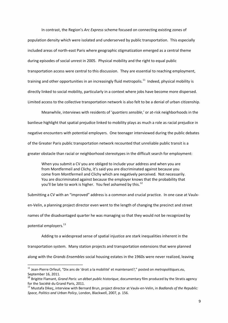
In contrast, the Region’s Arc Express scheme focused on connecting existing zones of
population density which were isolated and underserved by public transportation. This especially
included areas of north-east Paris where geographic stigmatization emerged as a central theme
during episodes of social unrest in 2005. Physical mobility and the right to equal public
transportation access were central to this discussion. They are essential to reaching employment,
training and other opportunities in an increasingly fluid metropolis.11 Indeed, physical mobility is
directly linked to social mobility, particularly in a context where jobs have become more dispersed.
Limited access to the collective transportation network is also felt to be a denial of urban citizenship.
Meanwhile, interviews with residents of ‘quartiers sensible,’ or at-risk neighborhoods in the
banlieue highlight that spatial prejudice linked to mobility plays as much a role as racial prejudice in
negative encounters with potential employers. One teenager interviewed during the public debates
of the Greater Paris public transportation network recounted that unreliable public transit is a
greater obstacle than racial or neighborhood stereotypes in the difficult search for employment:
When you submit a CV you are obliged to include your address and when you are from Montfermeil and Clichy, it’s said you are discriminated against because you come from Montfermeil and Clichy which are negatively perceived. Not necessarily. You are discriminated against because the employer knows that the probability that you’ll be late to work is higher. You feel ashamed by this.12
Submitting a CV with an “improved” address is a common and crucial practice. In one case at Vaulx-
en-Velin, a planning project director even went to the length of changing the precinct and street
names of the disadvantaged quarter he was managing so that they would not be recognized by
potential employers.13
Adding to a widespread sense of spatial injustice are stark inequalities inherent in the
transportation system. Many station projects and transportation extensions that were planned
along with the Grands Ensembles social housing estates in the 1960s were never realized, leaving
11
Jean-Pierre Orfeuil, “Dix ans de ‘droit a la mobilité’ et maintenant?,” posted on metropolitiques.eu, September 16, 2011. 12 Brigitte Flamant, Grand Paris: un débat public historique, documentary film produced by the Stratis agency for the Société du Grand Paris, 2011. 13
Mustafa Dikeç, interview with Bernard Brun, project director at Vaulx-en-Velin, in Badlands of the Republic: Space, Politics and Urban Policy, London, Blackwell, 2007, p. 156.
10
residents stranded far from work opportunities and with few travel options. This challenge becomes
acute as employment is dispersed throughout the region. And those with the least stable work must
be the most flexible and able to move to temporary opportunities around the region. Éric Le Breton
has documented this “dual fragmentation of work and territory” in the Paris region:
Our society is being subject to two major transformations: the fragmentation of territory and the fragmentation of work, that are profoundly redefining the organization of time and the spaces of daily life. In this context, the capacity of mobility is becoming a determinant factor for social integration. But low income populations have the least mobility capacity at the same time that they are confronting a pronounced disorganization of their daily life.... Today, the overlap between of zones of work and zones of residence has been disturbed. Employment is less sure, the locations of firms less perennial. Workers must seek out work wherever it may be located....The imperative of mobility is even stronger when persons are less skilled. In effect, teenagers, isolated women, immigrant workers often have access to work only through atypical employment (limited contract, interim, shift work). This fractioning of work, day and night, weekday and weekend, in one firm for a short period, then in another situated elsewhere, imposes upon them more numerous and more dispersed journeys. Yet they have limited means of transport with which to face this imperative. In the 2000s, more than half of the most modest households had no car.14 Furthermore, the fare structure and layout of the existing public rail system places the
highest cost burden on those who can least afford it. Some of Paris’s poorest suburban residents
must pay the highest rates in the Metro/RER system as the fare scale is based upon distance
traveled. In addition, the star shaped network makes traveling within the periphery even more
costly because one is forced to travel to the center and outward again through multiple fare zones.
Such trips are long and expensive.
Claims of harassment by police also contribute to a sense of unequal treatment within the
transport system and restrictions on mobility. Suburban youths are regularly stopped by police for
identity checks at major stations without specified cause.15 When police arrested a turnstile jumper
at the Gare du Nord on March 27, 2007, a simmering sense of injustice instantly flamed into a riot
involving hundreds of youths and passersby.
14 Éric Le Breton, Bouger pour s’en sortir: mobilité quotidienne et intégration sociale, Paris, Armand Colin, 2005, pp. 18, 25, 43. 15
See Fabien Jobard and René Lévy, Profiling Minorities: A Study of Stop-and-Search Practices in Paris, New York, Open Society Institute, 2009.
11
Finally, restricted access to the collective transportation network is an implied denial of
urban and even national citizenship. Hughes Lagrange and Marco Oberti discuss this link between
public service provision and collective identity in a study of the root causes of the 2005 riots in the
Paris banlieue:
French social cohesion rests on a national conception of citizenship that formally unites all individuals around one nation, one language, one State, one set of rights, independent of their social, religious, ethno-racial or territorial differences....More broadly, the welfare state constitutes a fundamental pillar of social solidarity through the strong presence of public services in the major domains of social life: education, health, family, transport, urban development and planning, housing....This posture (of a "national society") implies a guarantee of the same equality of opportunities to each individual, whatever his territorial situation. Because French society, through the State and its public services, claims to guarantee a relative homogeneity of the conditions necessary for integration and social success throughout its territory, this model has been able to have an indispensible legitimacy for maintaining strong social cohesion.16
This social compact breaks down when the provision of services such as transport becomes highly
unequal. Car burning during riots in the banlieue is a symbolic act that communicates this
breakdown in violating property, but it is also a fatalistic gesture, destroying what little means of
mobility exist in isolated zones of the metropolis.
Le Grand Huit vs. Arc Express
The Débat public sur le projet de Réseau de transport du Grand Paris, the most extensive
participatory planning effort ever undertaken in France, took place from September 2010 through
January 2011. Its fifty-five meetings were attended by approximately fifteen thousand people. The
objective of this process was to debate the merits of the Region’s Arc Express versus the State’s
Grand Huit regional train proposals. Again, the first emphasized serving current needs and areas of
population density, especially isolated communities impacted by poverty and social unrest. The
latter emphasized establishing new economic poles further into the periphery, with efficient air and
TGV connections. At the core of this debate, embodied by each proposal, are two conflicting
16 Hughes Lagrange and Marco Oberti, "Intégration, Ségrégation, et Justice Sociale," in Hughes Lagrange and Marco Oberti,eds., Émeutes Urbaines et Protestations: Une singularité française, Paris, Presses de Sciences Po, 2006, pp.19-20.
12
narratives of mobility – the “global city” versus the “just city.” And indeed, themes arising in the
debate illustrate many of the dilemmas of the network city and its difficulty reconciling economic
growth priorities and social fairness.
A remark contributed at a public meeting by Patrick Braouezec, then Deputy of Seine-Saint-
Denis, highlights this dilemma:
First, I appreciate enormously the fact that, for once, we’re hearing from everyone’s mouths that the question of the attractiveness and competitiveness of Paris and of the Ile-de-France region will come from the reduction of social and territorial inequalities, and that public transport is one of the essential threads with which to achieve this.17
In reality, the difficulty finding a nexus between global competitiveness and social justice has proved
the greatest challenge of contemporary urban development trends. Gabriel Dupuy recognizes
networked urbanism to be a condition generating both economic growth and widening inequality.18
Pierre Veltz also addresses this conundrum:
One increasingly has the impression of an ‘archipelago economy’ in which horizontal, frequently transnational, relations increasingly outmatch traditional vertical relations with the hinterland. What explanation is there for such polarization at a time when the growing fluidity of communication and the volatile – in particular, uncapitalistic – character of the most remarkable activities in modern capitalism ought to be leading towards a more footloose economy, in which places and concentrations are a matter of indifference?19
Remarks at a meeting by Claude Bartolone, then President of the General Council of Seine-
Saint-Denis, more somberly describe what Graham and Marvin would analyze to be the “splintering”
effects of Paris’s infrastructure network:
In spite of the poverty of the Seine-Saint-Denis population, this is the department with the highest dependence on individual cars, because unfortunately, public transportation is so retrograde. Transportation from banlieue to banlieue poses the greatest difficulty.
17
Patrick Braouezec, Deputy of Seine-Saint-Denis, remarks at a Débat public sur le projet de Réseau de transport du Grand Paris meeting in Saint-Denis, October 13, 2010. 18 Gabriel Dupuy, Urban Networks / Network Urbanism, (English edition), Amsterdam, Techne Press, 2008. 19
Pierre Veltz, “European cities in the world economy” in Cities in Contemporary Europe, Arnaldo Bagnasco and Patrick Le Gales (eds.), Cambridge, Cambridge University Press, 2000. pp. 33-34.
13
He also expressed concerns about potential “bypass” effects of the State’s Grand Huit
proposal, another dynamic described by Graham and Marvin20:
I would not want that under the feet of the residents of the most disadvantaged neighborhoods should run a high quality train permitting businessmen and women to travel from one airport to another but which would stir an odd feeling in those who are in so much need of transport, who would hear or even feel the metro running under their feet without having the possibility to imagine being able to take it one day.21
Bartolone’s concern was not only that a proposed super métro might bypass a low-income
area that is badly in need of transit, but that it might be priced at a level that is unaffordable to many
riders. This concern is justified, as high-speed airport express trains like the connection proposed
are frequently priced as “premium network spaces” to attract global business with an infrastructural
space that is socially exclusive.22
Anxieties about "bypass" were evident in other contributions to the debate. Residents
questioned for whom the new network was being planned and expressed a sense of being passed
over in favor of global firms. Valerie Grémont, a resident of the Plaine Saint-Denis was among them:
In the end, this district will be transversed by all sorts of transport, but I can assure you that if there are so few people in the room today, it is because they cannot get here. You do realize that we have 50,000 transportation projects proposed: Arc Express, Grand Paris, a mobilization plan... and me, from my home, I cannot get here on public transport. And the proposed transport plan will not address this. ... When we see in your document the station at La Defense, at the pole of La Defense!... Today, there are two buses [from the RER station - which in itself was only built as provisional]. And yet, when I say two buses, one is a bus that was canceled, was deviated ... so my neighborhood is not served. This is thus a bus and a half. You can already see the urgency to rethink what you're proposing, to have immediate and emblematic responses.23
20 Stephen Graham and Simon Marvin, Splintering Urbanism: networked infrastructures, technological mobilities and the urban condition, London: Routledge, 2001. 21 Claude Bartolone, President of the General Council of Seine-Saint-Denis, remarks at a Débat public sur le projet de Réseau de transport du Grand Paris meeting in Saint-Denis, October 13, 2010. 22
See Stephen Graham, "Constructing Premium Network Spaces: Reflections on Infrastructure Networks and Contemporary Urban Development," in the International Journal of Urban and Regional Research, Vol 24.1, March 2000. 23 Valerie Grémont, resident of La Plaine Saint-Denis, remarks at Débat public sur le projet de réseau de transport public du Grand Paris, "urbanisme et quartier" thematic meeting at La Plaine Saint-Denis, October 27, 2010.
14
Although many communities hoped the proposed network might draw new employment
opportunities into their own precincts, and offer isolated youth easier access to universities and
educational opportunities, they questioned the engineers’ emphasis on speed and successfully
pressed authorities to increase the number of planned stops in order to distribute service more
fairly. Others stressed the need to connect residents of isolated housing estates to wider
metropolitan opportunities and the importance of a mobile workforce to Paris's long term economic
viability.24
Many of the concerns voiced in the public debate were not only focused on social fairness,
but also upon interrogating the validity of the economic cluster concept presented by the State’s
Grand Huit proposal. This is how the project was presented to the public:
The public authorities’ goal is to encourage density and territorial polarization (and thus productivity) through a policy of structuring mobility. The Grand Paris project is, thanks to a transport scheme conceived on the principle of polarized territorialization, at the heart of a global growth strategy. The ambitious but realistic aim of the project is to double the level of tangential growth of the region to 4% and create a million jobs by 2035.25
Although certain community actors supported this vision, this global growth model of infrastructure
was also called into question. On one hand, cities including Neuilly-Sur-Seine, and the Versailles
Grand Parc regional authority, submitted statements reinforcing the State's global growth vision.
The Grand Paris has foregrounded the necessity to change scale...in envisioning metropoles of the 21st century, where these no longer are defined around a center with its peripheries but around multipolarities… The double loop of Grand Paris, thanks to its interconnections with the rest of the world and its development of major poles around the Capital will permit this "world city" to reinforce its international attractiveness and ready itself for the emergence of new competitors."26
At the same time, this vision was heavily critiqued. For example, a video presentation of the Grand
Huit rail expansion highlighted the need for Paris to catch up to cities perceived to be pulling ahead
24
See for illustration "Le droit a la mobilité, un véritable enjeu pour les habitants du territoire," Cahier d'Acteurs 60, Communauté d'agglomération Vallée de Montmorency, November 2010. 25 CNDP presentation summary, Débat public sur le projet de Réseau de transport du Grand Paris meeting in Paris-Centre Marceau, October 13, 2010. 26
Cahier d'Acteurs 46, Ville de Neuilly-Sur-Seine, submitted to the Commission Particulière du Débat Public Réseau de transport public du Grand Paris, November 2010.
15
in global rankings, such as London, New York, and Tokyo. However, Paris’s transportation
infrastructure, even under its current strain is perceived to be at par with or superior to these other
cities. Alain Meyere, Director of Mobility and Transport at the Institut d’aménagement et
d’urbanisme d’Île-de-France (IAU), was among those questioning the logic of equating
transportation and global competitiveness:
We use the example of greater London and its economic dynamism. But what London tells us is that the relationship between transport and economic dynamism must be extremely tenuous. Because London has a transit organizing authority that is unique among major world cities in that it does not cover the entire basin of travel….It …does not deal with commuter trains or a regional network. Imagine if the Paris authority were like this! The relationship is complex. It is not as simple as you would have us believe.27
While research studies were presented to support the cluster strategy, critics remarked that cluster
theories were either outdated or unobserved in France and that transportation individuation and
intermodal “weaving” rather than polarization would offer more economic gain and mobility
choice.28
For critics such as Cécile Duflot, recently appointed Minister of Territorial Equality and
Housing, the cluster concept was simply a global marketing strategy, divorced from concerns of an
existing metropolis or “costly problems of a hinterland” in the words of Pierre Veltz (2000). Duflot
offers a decidedly anti-splintering stance:
The Grand Paris cannot simply remain a transportation project...we cannot consider that it will suffice, in order to respond to the expectations of 12 million Ile-de-France residents, to link together poles of excellence simply in the name of promoting their economic attractiveness for a territorial marketing campaign...The Grand Paris won’t make sense if it is constructed for global competitors more than for its inhabitants. The Grand Paris will not become Dubai-sur-Seine.29
Yet, given the Paris region’s pressing economic concerns, and its primary importance in France’s
economy, Olivier Coutard would invite us to take into account the “other side of the coin” of the
27Alain Meyere, Director of Mobility and Transport at the Institut d’aménagement et d’urbanisme d’Île-de-France (IAU), comments at Débat public sur le projet de réseau de transport public du Grand Paris, “urbanism and neighborhood” thematic session at La Plaine Saint-Denis, October 27, 2010. 28 See for example the comments of Alain Leikine, Vice-Président du Conseil général du Val d’Oise, Débat public sur le projet de Réseau de transport du Grand Paris meeting in Paris-Centre Marceau, October 13, 2010. 29
Gilles Davoine and Jacques-Franck Degioanni, “Cécile Duflot – ‘Le Grand Paris ne sera pas Dubai-sur-Seine’,” Le Moniteur, June 26, 2012.
16
State’s globalization-oriented infrastructure proposal by taking a wider view of its potential to
socially redistribute income generated by growth:
The issue then is not whether the “archipelago” pattern of contemporary capitalism is fairer or harsher to hinterlands than previous patterns of “nationally embedded” capitalism: it is harsher (Veltz 1996)...Rather, the issue is to compare the public policies that support the new pattern with their sustainable alternatives – in terms of both the overall income generated and the redistributive effects...locally, nationally and internationally.30
Design as Politics: from Grands Projets to Grand Pari(s)
The fundamental transformation of the city into a networked territory is not only shaping
public space and mobility conflicts but it is radically altering how design is instrumentalized as a tool
in metropolitan politics. It is changing the way that politicians and other urban actors employ
architects in political maneuvers and also how architects themselves approach metropolitan
projects.
Within the fragmented political context of the Paris agglomeration, architecture is playing a
increasingly strategic role in helping politicians and other stakeholders (such as the region’s transit
authorities) create media interest and build public support for their proposed approach, even
without control of institutional mechanisms necessary to implement it. For example, the Grand
Pari(s) design consultation and exhibition allowed the State to gain control of the narrative about
greater Paris’s future, despite the fact that real institutional power had largely been transferred to
regional and local authorities under decentralization policies first initiated in the 1980s.
This strategic role of architecture marks a shift away from its more symbolic function in
politics, for example, during the era of President Francois Mitterrand’s Grands Projets. In the 1980s
and ‘90s, President Mitterrand and Mayor Jacques Chirac both employed architectural symbols in
the struggle between socialists and neo-gaullists to control national politics. While Mitterrand
sought to build great cultural monuments to the socialist collective, Chirac characterized these as
30 Olivier Coutard, “Urban Space and the Development of Networks: A Discussion of the ‘Splintering Urbanism’ Thesis” in O. Coutard, R Hanley, and R. Zimmerman, Sustaining Urban Networks: the social diffusion of large technical systems, London, Routledge, 2005, pp. 56-57.
17
products of an aloof socialist elite and countered with a building program of “populist” projects. In
the context of greater Paris, President Sarkozy’s pragmatism could be characterized as a shift from
deployment of architecture’s symbolic power to its effective power in urban politics.
The State’s initiative to direct development of the Paris agglomeration, loosely referred to as
Grand Paris, began with an address by Sarkozy at the opening of the Roissy 3 air terminal in June,
2007 and continued at his inauguration of the Cité de l’Architecture et du Patrimoine, national
architecture museum and library in September, 2007. Responding to pressure to address social
unrest in the banlieue and to accusations that he was callously disinterested in the plight of the
suburbs, Sarkozy suggested that architecture be deployed to consider both city and periphery. Also
on his mind was the upcoming mayoral election in Paris, in which he hoped a conservative party
candidate would be successful and the relationship of Paris to the suburbs was a key issue. He
further proposed that a new global plan for greater Paris to be the subject of an international design
consultation. By mid-2008, ten interdisciplinary teams led by high-profile architects were
commissioned by the Ministry of Culture to spend nine months studying the future development of
the Paris agglomeration. The results of this consultation were internationally publicized and
exhibited at the Cité from April to November of 2009.
Taking many of the architects and Regional authorities by surprise, toward the end of the
work of the teams, Christian Blanc, Sarkozy’s State Secretary for Development of the Capital Region
unveiled his Grand Huit plan for a regional “super métro” and seven new economic development
poles.31 At the close of the exhibition, the Grand Huit plan was advanced by the State, and the
architect teams complained bitterly that, after such extensive study, few if any of their
recommendations were adopted.
Whether or not this was the original intention, the Grand Pari(s) design consultation
permitted the State to retake control of planning for greater Paris from Regional authorities in order
to promote its own priorities for the capital. Where the Region’s emphasis was on rebalancing
31 Conversation with architect Bernardo Secchi, October 29, 2011.
18
mobility inequities, particularly in disadvantages communities, the State’s goal was to promote
business interests and Paris’s economic position on a global stage. The highly mediatized design
consultation, in effect, allowed the State to appear to be directing the thinking process, and it also
bought time for Secretary Blanc to formulate his own counter plan to the Region’s.
A Changing Political Context
The differences of approach between the State and Regional propositions stem partly from
the multiple roles of the Paris agglomeration and its fractured governance. Paris is at once a global
city, a national capital, and a local municipality. To many, Paris is France. It contains by far the
highest concentration of population and economic activity in the nation and is the country’s
economic and cultural engine. For this reason, the State is reluctant to cede control of the capital
and prioritizes global interests. Meanwhile, the city’s local interests are frequently in conflict with
those of the State. France’s presidents have often leaned to the political right of the Capital region,
as they are elected primarily by the more conservative provinces. Meanwhile Paris and its
concentration of workers have generally leaned left. This is particularly true of the regional
municipalities in the Paris agglomeration that are the historic home of the industrial working class.
The Regional Council has always been resistant to control by the right, putting it in direct conflict
with Sarkozy’s presidency. Such fragmented political interests make metropolitan governance a
challenge.
In addition, Paris has been subject to a national policy of decentralization since the 1980s,
which granted more autonomy to regional and local authorities and eroded the State’s centralized
technocracy. While Sarkozy made several gestures to return to centralization – such as the
appointment of a Secretary of State for the Development of the Capital Region and creation of an
autonomous authority, the Société du Grand Paris, charged with securing territory and financing for
the super métro project – in the end most implementation mechanisms remain in the hands of the
Region and local authorities.
19
In contrast to the era of Paris prefect Paul Delouvrier, when a handful of officials and
engineers controlled decisions to construct the Villes Nouvelles and the RER rail system in the 1960s,
political advocacy movements have also created requirements for extensive public participation.
Indeed, the Débat public sur le projet de Réseau de transport du Grand Paris, to debate the State and
Region’s conflicting transportation proposals, was France’s most complex participatory planning
exercise to date. Another essential shift since the Delouvrier era is the dependence on the private
sector partners to finance and construct urban projects.32 Borrowing a term from Deleuze, State
Secretary Christian Blanc appropriately described as a “rhizome” the open-ended plan and
transportation network being assembled in this context of partnered, negotiated urbanism.”33
Asked whether he views Sarkozy’s Grand Paris initiative as an attempt at recentralization,
Vincent Feltesse comments that there is a difference between a strategic semblance of
centralization and actual institutional centralization, which he feel is in any case outmoded:
First we have Nicolas Sarkozy who has borrowed the expression “Grand Paris” and launched it into the space of media and politics. His second successful step has employed an innovative methodology: an international consultation, with pluralist teams who really have carte blanche. But the mistake is to have believed that the State could advance without the regional authorities… The whole problem is to recreate a national centralized intelligence in a decentralized country. Today, it is the State who continues to give structure to things, but it no longer has the mechanisms for regional action. And the regional authorities, who have these mechanisms, don’t have the capacity to integrate things at the national level… But in this mobile world, will the solution really come by way of a single, permanently fixed frame? Looking at our European neighbors, territorial governance takes on a variable geometry34
32
For a discussion of public-private partnership in contemporary France, see Isabelle Baraud-Serfaty, “La nouvelle privatization des villes,” in Esprit No. 373, March-April 2011. 33 Christian Blanc, 2010, p. 149. 34 Interview with Vincent Feltesse, founder of Les Métropolitaines think tank, president of the Bordeaux regional authority, president of the National Federation for Urbanism Agencies, “La métropolitisation honteuse” in Esprit No. 373, March-April 2011, p. 145.
20
From Architecture to Infrastructure
Also of interest is how the complexity of greater Paris influenced the work of the Grand
Pari(s) architecture teams themselves. Stephen Graham begins a discussion of the relationship
between architecture and networked urbanism with a provocative statement from Lars Lerup:
Architecture has been pitilessly absorbed into the metropolis….The metropolis has replaced the city, and as a consequence architecture as a static enterprise has been displaced by architecture as a form of software.35
Graham surveys the work and writings of contemporary architectural theorists including Rem
Koolhaas, Keller Easterling, Alex Wall and others and concludes that in the contemporary city, flows,
infrastructure, architecture, and landscape are now considered together by designers as a single
complex or field.36
Most of the Grand Pari(s) architects indeed opted to study urban systems and infrastructure
rather than buildings, but approached these systems very differently. First, the team led by British
architect Richard Rogers, offered a techno-utopian vision of Paris’s green future with the
transformation of the city’s major rail corridors into a self-contained armature of the sustainable
city. Proposing that train rights-of-way could be layered with multimodal transport, wind
generators, water collectors, and linear parks, the Rogers scheme presented an ambitious, neo-
metabolist vision of Paris – a flexible (yet top-down) megastructure.
Antoine Grumbach was also interested in territorial-scale armature, reading the existing
landscape of the Seine River Basin as a system of infrastructure jointly engineered by man and
nature. Weaving the river into an accompanying network of express and regional transportation
lines, he de-centered Paris in its agglomeration to emphasize the city’s relationship to a larger
economic geography and represented the entire territory as a network map, appropriating the
graphics of the London underground.
35 Lars Lerup, After the City, Cambridge MA, MIT Press, 2000, p.22 quoted in Stephen Graham, Splintering Urbanism, London, Routledge, 2001, p.32. 36 Graham, 2001, p.32.
21
Grumbach’s interpretation of the regional landscape as infrastructure shares an interest of
other Grand Pari(s) architectural teams in reading the city as a complex system. Their objective is to
study this system and its internal rules, in order to appropriate them and intervene. This is related
to a parallel interest in the emergent metropolis – the city as a set of fragments and situations,
unique or typological, with the seeds of a larger metropolitan order contained within them – a sort
of metropolitan ‘DNA’ that directs a self-organizing, larger whole.
Nathalie Roseau observes this interest in complexity in her reading of how Grand Pari(s)
architects represented the idea of the metropolis:
It is also to this heterogeneous mosaïc that the AUC team addresses itself, adept, like team Lin, in a “philosophy of the discrete,” which establishes conditions of a possible mutation of the metropolis starting from situations that are at once local and specific, but which carry within them important metropolitan potentialities.37 For example, in contrast to the Rogers team’s techno-utopianism, the Jean Nouvel-Duthilleul
partnership proposed an elegant solution of extreme pragmatism. With a close study of all modes of
existing rail transportation in the region, and their existing travel times, Duthilleul (who contributed
the proposal’s subtlety through his experience as the architect of the French national railway)
devised a micro-weaving of existing lines and a unified ticket for a merged Metro, commuter rail and
TGV system that could reduce all trips across Paris to one half hour or less.
The L’AUC team’s approach meanwhile refused what Michel de Certeau would term a
“strategic” representation of greater Paris in its entirety, but depicted it rather as a matrix – an
accumulated series of “tactics” and micro-situations. One such situation, TTGL (très très grand
Louvre) looked at infrastructure as an intense generator of urban cosmopolitanism, depicting a mass
of urban cultural, commercial, and leisure program incorporated into the vertical section of a
regional metro station.
Similarly viewing the metropolis as an accumulation of specific conditions, Secchi and
Vigano, explored the “porous city” with a series of close studies of permeability – the weave of
37
Nathalie Roseau, “Le Grand Paris des infrastructures, un projet en crise?” in Dominique Rouillard, ed., L’Infraville: Futures des infrastructures, Paris, Archibooks + Sautereau, 2012, p. 59.
22
multiple scales of mobility flows into a patchwork of various urban tissues. In parallel, Studio Lin
took an approach they called the “light city.” This was a diffusion of multi-modal transport networks
into a range of samples of existing urban conditions in the Parisian periphery.
The Negotiated Network
Although the Grand Pari(s) design consultation can be interpreted as a strategy through
which the State regained control of the metropolitan narrative, this does not signal a return to the
centralized planning of the 1960s. Instead, it makes apparent new political strategies required to
operate in the fragmented, pluralist context of a complex agglomeration. Within this setting, an
infrastructure project itself can become a form of emergent governance and negotiated planning.
This appears to be the case of the Grand Paris Express regional rail proposal, the dominant project to
issue from the Grand Paris initiative.
From its inception, Grand Paris Express embodied a very different approach to regional
planning from the RER and Villes Nouvelles, which were realized during France’s most technocratic
era. The outlines of the early Grand Huit route traced a set of individual political deals struck by
State Secretary Christian Blanc with regional mayors and local authorites – a map of politics, not of
engineering.38
Its next phase incorporated the vast Débat Public, which though not its mission, coaxed a
negotiation from the State and Region. In response to an impasse between the State Secretary and
the Regional Council, the independent Commission Nationale du Débat Public launched the process
to debate the Arc Express and Grand Huit rail proposals and greater Paris’s public transportation
future. The Commission was formed in the mid-1990s to facilitate public debate of urban planning
initiatives. Among the issues discussed in public meetings held throughout the agglomeration over a
four month period were mobility inequity, station locations, and financing strategies. The sessions
were filmed, fully transcribed, summarized, and made available to the public. Towards the end of
38
Interview with Yannick Beltrando, Director of the Metropolis Work Group at the Atelier Parisien de l’Urbanisme (APUR), November 12, 2010.
23
the public process, the Region and the State, feeling pressure from the debates’ exposure of their
political paralysis, struck a compromise and issued a new plan, the Grand Paris Express.
The most significant innovation in the process has been the creation of the Contrat de
Développement Territorial (CDT) mechanism which, in effect, locally distributes development
responsibility. The law founding the Société du Grand Paris, the authority responsible for
establishing territory and financing for the project, also created CDT contracts allowing local and
regional authorities whose territory lies along the proposed route of the Grand Paris Express, to self
organize into groups and collectively propose local urban development plans. These must define a
development zone, address issues such as housing, transportation links, sustainability, public
participation, and financing and implementation strategies. In turn, many of these local plans rely
upon private sector partners, distributing development control even further. Through the CDT, local
authorities enter into an agreement with the State, who is represented by the prefect of the
Region.39 Nearly twenty of such plans are currently underway, and the local collectives have been
given 18 months to complete them.40
Although still in an experimental stage, the CDTs may create an opening for what Coutard
and Guy describe as a “politics of hope” and urban readings employing the tools of science,
technology and society studies:
Within an STS framework of analysis, therefore, a more plausible prediction might be that while in some instances both network and urban inequalities grow in a mutually-supporting process, in other instances this is not the case.41
They incorporate micro-struggles into the planning process and leave room for concepts that
Amin and Thrift term “performative improvisation” and for Georges Perec’s
“everydayness.”42
39 Décret n° 2011-724 du 24 juin 2011 relatif aux contrats de développement territorial prévus par l'article 21 de la loi n° 2010-597 du 3 juin 2010 relative au Grand Paris. 40
Le Monde, “Le Grand Paris dans les starting-blocks,” September 14, 2011. 41 Olivier Coutard and Simon Guy, “STS and the City: Politics and Practices of Hope” in Science, Technology, & Human Values, Vol. 32, No. 6, Middle-Range Theories in Science and Technology Studies (Nov., 2007, pp. 713-734. 42 Ibid.
24
Other theorists explore how infrastructure networks engender indirect forms of governance
and coordination in large, highly fragmented urban agglomerations. Sociologist Dominique Lorrain
posits that, particularly in the developing world, “rather than a scenario of catastrophe,” complex
mega-cities “find themselves governed indirectly by network services. To construct and manage
these technical systems, it is necessary, consciously or by default, to resolve institutional questions
concerning legal status, organization and financing.”43 He further analyzes how infrastructure
projects achieve this both by shaping space and by offering an opportunity that is easily recognized
as extraordinary:
Our argument is to consider how these objects (major infrastructure and networks…) represent an opening to address the problem of governing large metropoles. First, they form a backbone of the city… organizing space and avoiding a soup without hierarchy. Furthermore, these technical systems are put in place with operations that are out of the ordinary, either in their level of investment, technical feats, and irreversible consequences on the structure of cities. To realize them, urban governments are forced to resolve numerous institutional problems.44
Political scientist Paul Kantor, reads a parallel phenomenon in the New York region.
According to Kantor, recent megaprojects in the New York area represent the most extensive
infrastructure improvements since the top-down era of Robert Moses. However, these have been
realized through a more decentralized process and very little direct cooperation between local
authorities. Kantor believes that local governments prefer to “coordinate rather than cooperate”
but that they are spurred to do so when they recognize an opportunity that is out of the ordinary,
such as an infrastructure project presented to them by a public benefit corporation:
Governments often get a lot done without cooperation, and they usually don’t want to collaborate. Governments don’t need a lot of cooperation to manage problems of regional scope. Political cooperation by local government arises from the fear of being left behind by public agencies and infrastructure builders.45
43 Dominique Lorrain, “The Institutions of Urban Fabrication” in Métropoles XXL en pays émergents, Dominique Lorrain ed., Paris, Les Presses de Sciences Po, 2011, p. 14. 44
Ibid, p. 15. See also Patrick Le Galès and Dominique Lorrain, “Gouverner les Très Grandes Métropoles?” Revue Française d’administration publique, March 2003 no107, p. 305-317. 45 Paul Kantor, presentation to workshop on “Governance players,” at Paris, Metropoles, Le Defi de la Gouvernance international seminar at Paris City Hall, December 1, 2011. See also Paul Kantor, Christian Lefèvre, Asato Saito, H. V. Savitch, and Andy Thornley, Struggling Giants: Governance and Globalization in the London, New York, Paris, and Tokyo City Regions, Minneapolis MN, University of Minnesota Press, 2012.
25
Finally, sociologist philosopher Bruno Latour deploys actor-network theory to describe how
objects themselves – such as infrastructure proposals and new technologies – become powerful
actors in processes of metropolitan democracy. However, he also recounts how it is essential for
new technology to respond to specific local political culture in order to be successful. 46
In the context of greater Paris, the Grand Paris Express proposal is indeed an actor – an
agent that is forcing negotiation between disparate parties in a vast and varied agglomeration.
These parties include more than two hundred municipalities, local and regional collectives, the State,
the Regional Council, and participants in the broadest participatory process in France’s history.
Added to the mix is the private sector, which has become a dominant player in the urban
development of the Paris region as its primary source of financing. A proposed new network, a
“super metro” recognized as a singular opportunity, is coaxing an incremental plan for the
metropolis that is developing piece by piece, negotiation by negotiation. This represents an extreme
departure from the totalizing visions of technocratic regional plans of the 1960s and ‘70s.
46 Bruno Latour, Aramis, or the Love of Technology, Cambridge MA, Harvard University Press, 1996. See also Bruno Latour, Reassembling the Social, an introduction to Actor-Network-Theory, Oxford, Oxford University Press, 2005.