Council Meeting Agenda 16/11/15 10 Chandler Highway Bridge Duplication Abstract The Victorian Government confirmed the allocation of $110 million in the 2015-2016 Victorian budget for the Chandler Highway Bridge upgrade project. The VicRoads project team has developed four road and bridge alignment options west or east of the existing Chandler Highway Bridge, namely: 1. West alignment - six lanes. 2. East alignment - six lanes. 3. West alignment - four lanes. 4. East alignment - four lanes. VicRoads has publically stated that the west alignment, six lanes option is their preferred option. With all options, the existing Chandler Highway Bridge is to be retained and repurposed as a shared path. From a review of the available documentation and plans, the west alignment options provide a greater benefit to the City of Boroondara than the east alignment options in that: - No land is required in excess of the existing Crown land set aside for road purposes. - The Guide Dogs Victoria facility is not impacted in terms of land required. - Willsmere Chandler Park and associated high value vegetation is not impacted. - The location of the shared path on the east side of Chandler Highway from the Yarra River to Heidelberg Road is considered to be a safer outcome for path users. The traffic impacts of the options presented are currently unknown, but are expected to be very similar for the two proposed alignments. The traffic treatments will be the same, including the signalisation of the Yarra Boulevard/Chandler Highway/Guides Dog Victoria facility and the removal of the existing two stage pedestrian operated signals located to the south of Yarra Boulevard. Council officers consider that the west alignment six lane option is the most suitable option in that it can achieve the key objectives of reducing congestion, improving safety and reliability for all road users with the added benefit of no land impact on Willsmere Chandler Park and the Guide Dogs Centre. The City of Yarra, through a Notice of Motion, has indicated that it does not support a proposal for a six lane Chandler Highway widening or a six lane bridge. The positions of the City of Darebin and the City of Banyule are not yet known. VicRoads sought community feedback on the design options from 15 October 2015 till 15 November 2015. City of Boroondara Chandler Highway Bridge Duplication Page 1 of 22
Transcript
Council Meeting Agenda 16/11/15
10 Chandler Highway Bridge Duplication
Abstract The Victorian Government confirmed the allocation of $110 million in the 2015-2016 Victorian budget for the Chandler Highway Bridge upgrade project. The VicRoads project team has developed four road and bridge alignment options west or east of the existing Chandler Highway Bridge, namely:
1. West alignment - six lanes. 2. East alignment - six lanes. 3. West alignment - four lanes. 4. East alignment - four lanes.
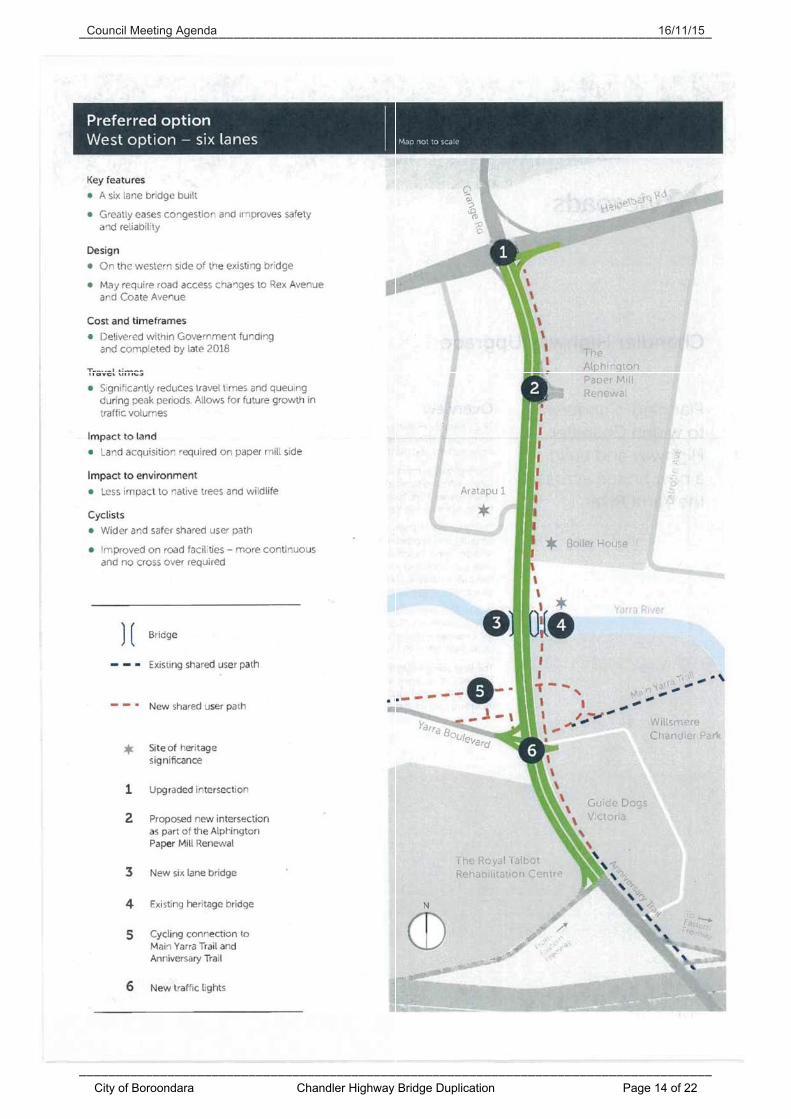
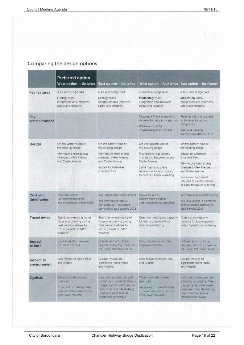
VicRoads has publically stated that the west alignment, six lanes option is their preferred option. With all options, the existing Chandler Highway Bridge is to be retained and repurposed as a shared path. From a review of the available documentation and plans, the west alignment options provide a greater benefit to the City of Boroondara than the east alignment options in that:
- No land is required in excess of the existing Crown land set aside for road purposes.
- The Guide Dogs Victoria facility is not impacted in terms of land required. - Willsmere Chandler Park and associated high value vegetation is not
impacted. - The location of the shared path on the east side of Chandler Highway from the
Yarra River to Heidelberg Road is considered to be a safer outcome for path users.
The traffic impacts of the options presented are currently unknown, but are expected to be very similar for the two proposed alignments. The traffic treatments will be the same, including the signalisation of the Yarra Boulevard/Chandler Highway/Guides Dog Victoria facility and the removal of the existing two stage pedestrian operated signals located to the south of Yarra Boulevard. Council officers consider that the west alignment six lane option is the most suitable option in that it can achieve the key objectives of reducing congestion, improving safety and reliability for all road users with the added benefit of no land impact on Willsmere Chandler Park and the Guide Dogs Centre. The City of Yarra, through a Notice of Motion, has indicated that it does not support a proposal for a six lane Chandler Highway widening or a six lane bridge. The positions of the City of Darebin and the City of Banyule are not yet known. VicRoads sought community feedback on the design options from 15 October 2015 till 15 November 2015.
City of Boroondara Chandler Highway Bridge Duplication Page 1 of 22
Council Meeting Agenda 16/11/15
Given the lead time with Council meetings, a request for an extension until 18 November 2015 was made to allow Council to consider and lodge a submission. This request was granted by VicRoads.
Officers' recommendation That Council resolve to:
1. Endorse a preference for the six lane west alignment option for the proposed Chandler Highway upgrade project.
2. Write to elected member representatives, the VicRoads Chief Executive Officer, the Chandler Highway Project Director and the Cities of Yarra, Darebin and Banyule to advise of Council’s preference for the six lane west alignment option.
3. Write to VicRoads to seek further information regarding the following for the west alignment option noting the limited detailed information available at the concept design stage:
i. The impact of the project and traffic on the wider network.
ii. Any proposals or plans for improvements to other areas of the network impacted by the project.
iii. Support for the introduction of additional on-road public transport services, specifically services to better connect Darebin, Banyule, Yarra and Boroondara.
iv. Possible noise impacts of the six lane west alignment option, specifically for the Guide Dogs Victoria facility and the Royal Talbot Rehabilitation Centre and how these will be addressed.
v. The proposed bicycle and pedestrian network upgrades, including connections to the Anniversary Trail and the Main Yarra Trail.
vi. Details of future consultation and engagement with the community and Councils.
Document information
City of Boroondara Chandler Highway Bridge Duplication Page 2 of 22
The purpose of this paper is to provide information on the Chandler Highway Bridge upgrade project currently under development by VicRoads and to seek a formal position from Council for inclusion in the community engagement on the same.
2. Policy implications and relevance to council plan
The Chandler Highway Bridge upgrade project is consistent with the following items as defined in the Council Plan 2013-17 and associated Annual Plan 2015-16:
- Theme: ‘Enhanced amenity’ - Strategic objective: ‘The character of our neighbourhood is protected and
improved’ - Strategy 11: ‘Parking, traffic and transport - we will respond effectively and
efficiently to community needs on parking, traffic and appropriate transport issues.’
3. Background
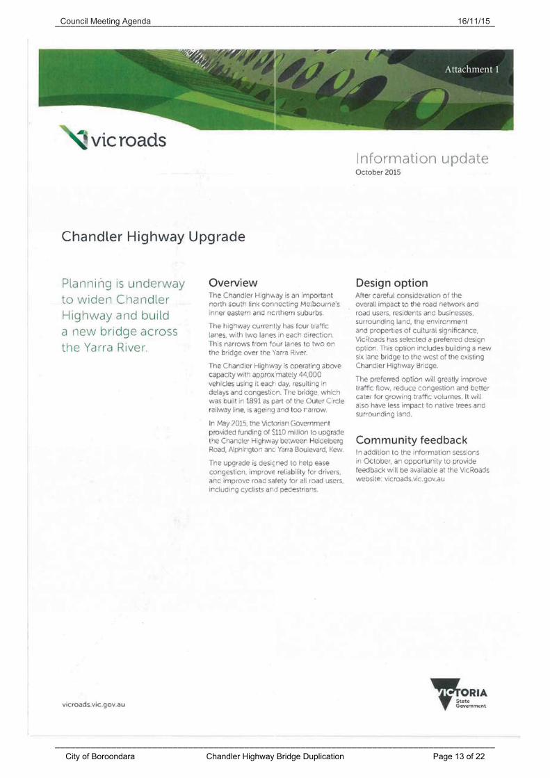
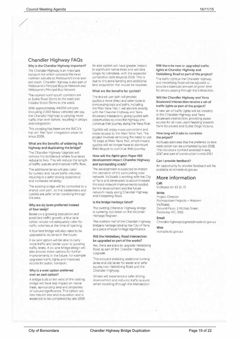
As part of an election commitment, the Victorian Government pledged to upgrade the Chandler Highway Bridge to ease high levels of traffic congestion. The 2015-2016 Victorian budget confirmed the allocation of $110 million for the design and delivery of the project. The Chandler Highway is an important north-south link from Heidelberg Road, Alphington to Princess Street, Kew East that connects Melbourne’s inner eastern and northern suburbs. Approximately 1.4 km in length, it forms part of the VicRoads SmartRoads Priority Vehicle Network, Principal Bicycle Network and Principal Bus Network. It is one of few river crossings, with the closest alternative north-south river crossings approximately 5km to the east (Burke Road) and 5km to the west (Hoddle Street). The road is subject to a 60km/h speed limit and currently has two lanes in each direction, which narrows to one lane in each direction at the bridge over the Yarra River. The separated off-road shared path on the bridge is narrow, has poor connections on the north side of the bridge and provides a sub-standard crossing of the Yarra River for cyclists and pedestrians. Chandler Highway is operating at capacity during much of the day resulting in significant delays, associated extensive queuing and congestion onto the wider network.
City of Boroondara Chandler Highway Bridge Duplication Page 3 of 22
Council Meeting Agenda 16/11/15
VicRoads estimates that 44,000 vehicles use the road each day including 2,000 heavy vehicles. It is known that 62 buses travel on the road each day and, based on information from the City of Yarra, approximately 160 cyclists use the road in the AM peak period. The Chandler Highway bridge is a bottleneck in the road network and has been rated as one of RACV’s top two ‘Red Spot’ congestion sites in the last three ‘Red Spot’ surveys (2010, 2012 and 2014). The existing Chandler Highway Bridge was constructed in 1891 as part of the Outer Circle train line. In 1930 the rail bridge was converted to a road bridge and the major original structural elements remain relatively intact and well preserved to this day. It is considered that it is not possible to retrofit additional lanes to the existing bridge structure. Additionally, VicRoads has completed an assessment of the existing bridge structure and noted that while the bridge is safe, that there are some structural issues with the continued use of the existing bridge carrying 2,000 heavy vehicles per day and that future maintenance would be likely. A number of existing problems have been identified for the Chandler Highway by VicRoads, including: - Current demand and limited river crossings causing significant delays and
network disruptions for public transport and private vehicles. These impacts are applicable to the Eastern Freeway, Chandler Highway and Heidelberg Road.
- Anticipated population growth and known future infrastructure upgrades will exacerbate delays and network congestion.
- Ageing infrastructure requires upgrades to meet current standards. The project, as developed by VicRoads, seeks to address these identified problems.
4. Outline of key issues/options
4.1 Design options VicRoads has developed four concept design options for the upgrade of the Chandler Highway. The four options are as follows: West alignment - six lanes (VicRoads preferred option). East alignment - six lanes. West alignment - four lanes. East alignment - four lanes. All four options feature the following: - Upgrade works extend from the Eastern Freeway off-ramp (at the south
end of Royal Talbot) to Heidelberg Road. - Retention of the existing bridge as an off-road shared path. - Signalisation of the Yarra Boulevard/Chandler Highway/Guide Dogs
Victoria intersection. - Removal of the existing two stage pedestrian operated signals south of the
Yarra Boulevard/Chandler Highway/Guide Dogs Victoria intersection.
City of Boroondara Chandler Highway Bridge Duplication Page 4 of 22
Council Meeting Agenda 16/11/15
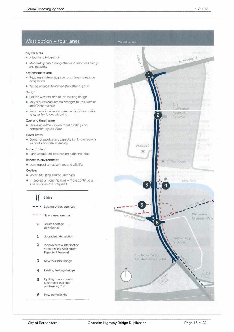
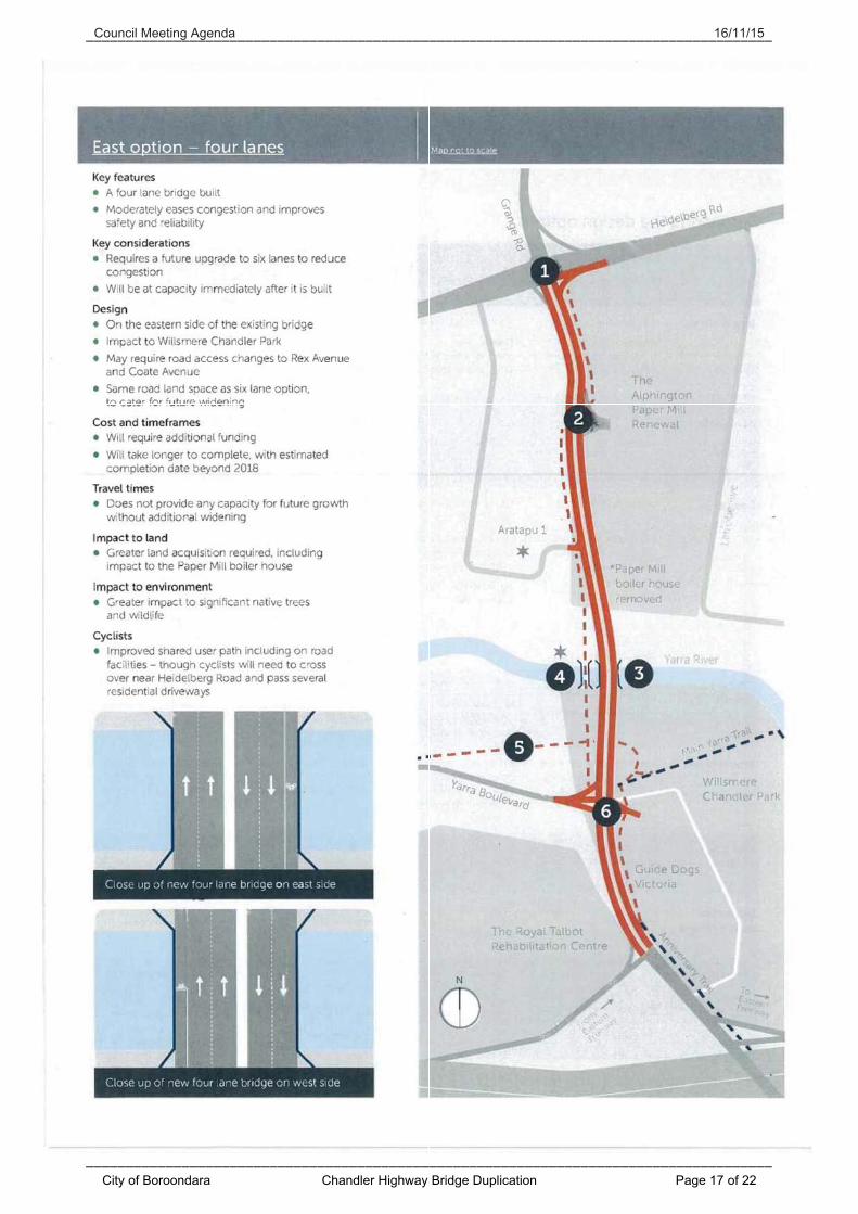
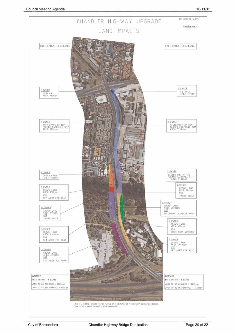
Concept designs for each of the four options are included within the VicRoads Information Update included as Attachment 1. In the October 2015 information update published on the project website and made available at the community information sessions, VicRoads stated the following: ‘Based on a growing population and predicted traffic growth, a four lane option would not adequately cater for traffic volumes at time of opening. A four lane bridge will also need to be upgraded to six lanes in the future. A six lane option will be able to carry more traffic and better cater to growing traffic levels. A six lane bridge design will also provide more options for further improvements in the future, for example upgraded traffic lights and improved access for public transport.’ With the above in mind, VicRoads has presented concept designs whereby both the six lane and four lane options on the two alignments occupy the same footprint of land. This is to allow the four lane option to be upgraded to a six lane option in the future. Discussion about the options from this point forward will focus on issues associated with the project as a whole rather than the four options. Where the issues differ for each option, this will be detailed. 4.2 Land acquisition A map detailing the land transfer and acquisition required for the project is included as Attachment 2. 4.2.1 West alignment options Nil land acquisition is required from within the City of Boroondara. The project proposes to utilise existing Crown land set aside for road. Approximately 5,700 m2 of land is required to be acquired from the AMCOR development site within the City of Yarra in accordance with their preferred design option. An additional 130 m2 of VicTrack land will also need be required from within the City of Yarra. No other land acquisition is required within the City of Yarra as the remainder of the proposed alignment is within the existing road reserve or land assigned road status within the planning scheme. The cost of the land required by the two west alignment options is included within the current project budget of $110 million, as well as the current project timeline. Construction is intended to finish by end 2018 for the west alignment options. 4.2.2 East alignment options Within the City of Boroondara, approximately 400 m2 of land currently occupied by the Guide Dogs Victoria (GDV) facility is required for the two east alignment options.
City of Boroondara Chandler Highway Bridge Duplication Page 5 of 22
Council Meeting Agenda 16/11/15
It is understood that GDV has had discussions with VicRoads to note their concerns with the east alignment options, the associated land requirement and the impact on their operations. A total of 2,000 m2 of land in Willsmere Chandler Park will be required for the project. The land is currently listed as Crown land for use of Willsmere Chandler Park. Approximately 10,100 m2 of land will need to be acquired from the AMCOR development site within the City of Yarra. This land requirement consists of two components, being:
1. 5,700 m2 associated with all four alignment options, and 2. 4,400 m2 associated with the east alignment options only.
It is understood that the cost of the second component of land is significant and is not included in the current project budget of $110 million. Significantly, as the east alignment land acquisition cost has not been factored into the project budget or plan the projected timeline for construction will likely not be met. The project team will be required to seek additional funding for the extra land acquisition from the Victorian Government. This will likely lead to a significant delay in the delivery of the project. 4.2.3 Guide Dogs Victoria The signalisation of the Yarra Boulevard/Chandler Highway/GDV intersection will improve accessibility of the GDV site. The potential of localised improvements specifically for the GDV facility associated with the west alignment has been flagged by VicRoads. Council officers are seeking details on possible noise impacts and how noise issues will be addressed, including the GDV facility. 4.2.4 Royal Talbot Rehabilitation Centre The Royal Talbot Rehabilitation Centre (the Centre) is not adversely impacted by the proposed alignment in terms of land acquisition. While the proposed alignment will be closer to the Centre than the existing roadway, it is contained within the existing road reserve. As with GDV facility, details on possible noise impacts for the Centre and how these will be addressed are also being sought. 4.2.5 Travel time savings VicRoads has advised that the travel time savings in the AM peak are in the order of 8 minutes and 13 minutes for the PM peak (northbound between Kew Junction and Heidelberg Road). These time savings are an average for all traffic within the VicRoads computer generated traffic model and include Chandler Highway and Heidelberg Road traffic.
City of Boroondara Chandler Highway Bridge Duplication Page 6 of 22
Council Meeting Agenda 16/11/15
The traffic modelling has taken into account the AMCOR development site in all four options as well as the removal of the Grange Road level crossing, given that the crossing is included in the list of 50 level crossings to be removed by 2022. 4.2.6 Wider traffic impact The impact of the project on the wider network is unknown at this point in time. All advice received to date indicates that the queues currently experienced during peak periods will significantly reduce as a direct result of the project. This is expected to include the traffic queues currently occurring on Chandler Highway and Princess Street in the City of Boroondara as a result of the bottleneck at the Chandler Highway Bridge. It can reasonably be expected that the volume of traffic using Chandler Highway will increase with the construction of extra traffic lanes. While the extra volume will be catered for on the Chandler Highway between the Eastern Freeway off-ramp and Heidelberg Road, it will be subject to the existing constraints of the unimproved wider road network. The Grange Road level crossing to the north and the Kew Junction to the south are the nearest existing and unimproved constraints within the wider network. The impact of the signalisation of the Yarra Boulevard/Chandler Highway/GDV intersection on the wider network is also unknown. While there will be significant benefits for motorists accessing the GDV facility, it can also be expected that traffic patterns on the Yarra Boulevard may alter as access from and to the Chandler Highway improves. This may result in increased traffic volumes on the Yarra Boulevard, a VicRoads maintained and managed road. The signalisation of the Yarra Boulevard/Chandler Highway/GDV intersection will greatly improve access across the Chandler Highway for pedestrians and cyclists. The removal of the existing pedestrian operated signals and associated two-stage road crossing is considered beneficial. The proposed intersection will allow for a single crossing movement at the desired crossing location. Further information about the traffic modelling is expected to be made available by the project team in December 2015. It is anticipated that this information will provide clarity around the impact on the wider traffic network, including within the City or Boroondara. 4.2.7 Parking restrictions The project has not yet addressed the need for any changes to existing parking restrictions on the wider road network. No parking is permitted on Chandler Highway, however parking is permitted on the east side of Princess Street south of Chandler Highway, located in the order of 1km from the bridge.
City of Boroondara Chandler Highway Bridge Duplication Page 7 of 22
Council Meeting Agenda 16/11/15
It is expected that VicRoads will undertake a detailed assessment to determine the need for any changes to parking restrictions. Should any proposals be identified, they will work with the impacted Councils through this process. 4.2.8 Road safety A review of the VicRoads Road Crash Information System (RCIS) for the period 1 July 2010 to 30 June 2015 for Chandler Highway between Heidelberg Road and the Eastern freeway off-ramp has indicated that 21 accidents occurred along the length of road. Of the 21 accidents, 2 resulted in ‘serious’ injury and 19 in ‘other’ injuries. No fatalities were recorded for the time period. The majority of accidents were rear end type. Of note is the fact that of the 55 persons involved in the accidents 29 were not injured, 23 received an ‘other’ injury which required medical attention and 3 suffered a ‘serious’ injury requiring hospitalisation. While a trend of rear-end accidents is clear from the available data, clusters of these types of slow speed, property damage only or ‘other’ injury accidents are not uncommon for stretches of road subject to traffic light control and heavy stop/start traffic. It is also a very difficult accident pattern to treat, with human error and frustration often the main causes. With the upgrade of the road and bridge, a smoother flow of traffic can be expected and the number of rear-end accidents may decrease. 4.2.9 Bike riding and walking The existing Chandler Highway Bridge is proposed to be retained in all four design options and it will be repurposed as a shared path. The detail of how this will be delineated is unclear at this stage. However, the retention and repurposing of the existing bridge is considered beneficial in that it has the potential to provide a good and safe off-road connection to the Main Yarra Trail. With the exception of the retention and repurposing of the existing bridge as a shared path, the interface between the Main Yarra Trail, the bridge and the Anniversary Trail is unclear. Extensive detail is not expected to be provided at a concept design stage and it is intended that Council officers work with the project team to ensure that the west alignment design options provide an excellent outcome for bike riders and walkers on the Main Yarra Trail and the Anniversary Trail.
City of Boroondara Chandler Highway Bridge Duplication Page 8 of 22
Council Meeting Agenda 16/11/15
West alignment options While details are limited, it is understood from discussions with the VicRoads project team and a review of the available concept design plans that, for the west alignment options, it is the intention of the project to: - Remove the 70 steps on the west side of the current bridge that form part
of the Main Yarra Trail. - Consider an underpass under the existing and new bridges to connect the
Main Yarra Trail. - Improve the connection to the Anniversary Trail to the south. The proposal for an underpass to address the steps issue was recommended by Council officers several years ago and formed part of a preliminary concept design developed with Parks Victoria at the time. This information was provided to VicRoads and is to be used as a base during the design stage. Additionally, in the west alignment options the shared path runs on the east side of Chandler Highway adjacent to the AMCOR development site. This results in no private driveway crossings and, pending approval of the AMCOR development plan, only one signalised intersection crossing. It is considered that these are very positive outcomes for safe walking and cycling. East alignment options As with the west alignment options, details are similarly limited for bicycle and pedestrian improvement works. The shared path will be on the west side of Chandler Highway for most of the length before switching to the east side using the proposed and yet to be approved AMCOR development site signalised intersection. The options provided will see path users crossing three driveways or road access points, a situation which is not desirable from a path user safety perspective. It is considered that this treatment will not encourage safe walking and cycling by the community and will be a barrier to use. 4.2.10 Public transport The project itself is not considering the delivery of additional on-road public transport services on the Chandler Highway. The project is expecting to improve travel times along the congested section of the road network and VicRoads is in discussions with Public Transport Victoria about the impact that this improved travel time would have on the delivery of additional services. The delivery of extra road capacity is not considered catalyst enough for the introduction of additional bus services. The extra capacity is expected to reduce travel times but not necessarily deliver extra patronage at the outset that is required to attain funding for additional services. It is anticipated that Public Transport Victoria will assess the bus routes in the area, including connections between Darebin, Banyule and Boroondara shortly after the completion of the project.
City of Boroondara Chandler Highway Bridge Duplication Page 9 of 22
Council Meeting Agenda 16/11/15
4.2.11 AMCOR Development site The AMCOR Development Plan is currently being considered by the City of Yarra, with community feedback closing on 4 November 2015. The Development Plan and associated works are being carried out by a private company and not the Victorian Government. As such and despite intrinsic links between the two projects, they must be considered as separate matters. Additionally, the Development Plan is being considered by the City of Yarra and the Chandler Highway project is being considered by VicRoads and the Victorian Government. As the project teams are different, so too are the assessors of the projects. It is known, however, that both project teams are in discussions with each other and are sharing information. 4.2.12 Doncaster Rail In June 2013 Council advised the Doncaster Rail Study Team of its preference for the Local Access option as detailed in the Doncaster Rail Study Phase One Draft Recommendations Report. This support remains unchanged. The proposal for Doncaster Rail involves the use of the Eastern Freeway median at grade and also underground in two sections, west of Yarra Bend Road and east of Bulleen Road. As the Eastern Freeway median is clear of the road widening and noting the level difference between the Chandler Highway and the Eastern Freeway median, officers are of the view that there will be no impacts for the future provision of Doncaster Rail. 4.2.13 Neighbouring Council consideration The City of Yarra, through a Notice of Motion on 20 October 2015, has indicated that it does not support a proposal for a six lane Chandler Highway widening or a six lane bridge. Rather it supports a road and bridge design that: (i) primarily provides practical options for integrated public transport and
better mobility for local residents requiring transport across the Yarra River and
(ii) builds-in future proofing design options for the construction of the Doncaster Rail.
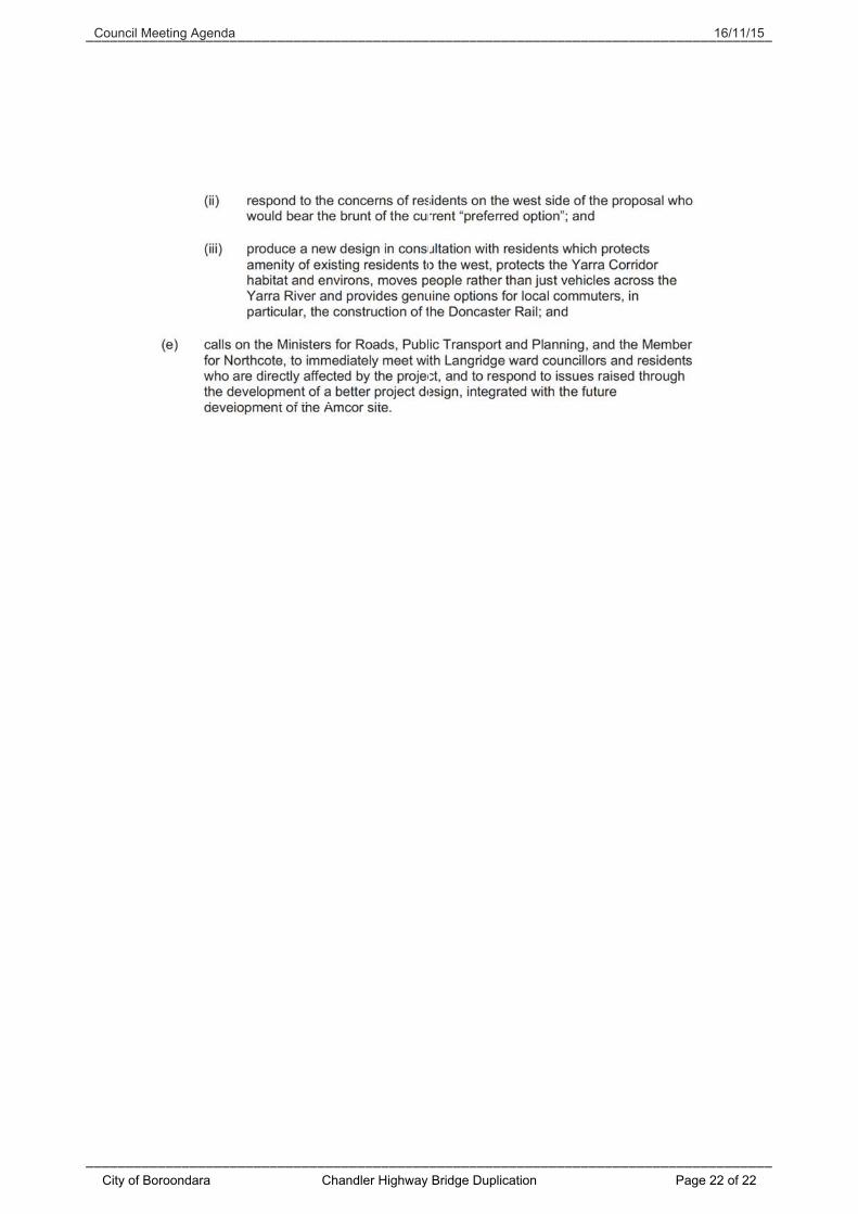
The motion also calls on VicRoads and the State Government to produce a new design in consultation with residents which protects the amenity of existing residents to the west, protects the Yarra Corridor habitat and environs and moves people rather than just vehicles across the Yarra River. The complete motion is included as Attachment 3. The positions of the City of Darebin and the City of Banyule are not yet known.
City of Boroondara Chandler Highway Bridge Duplication Page 10 of 22
Council Meeting Agenda 16/11/15
5. Consultation/communication
VicRoads has hosted two community information sessions at Northcote High School on St. Georges Road, Northcote on the following dates: - The evening of Tuesday 13 October, 2015. - The morning of Saturday 17 October, 2015.
The community information sessions consisted of: - An introduction from an external facilitator. - A project overview by the VicRoads Project Director. - Table discussion facilitated by a mix of VicRoads staff at each table and
recorded on ‘Post-It’ notes. - A facilitated Question and Answer session addressed to the project team
and the VicRoads Chief Executive Officer (CEO). - Closing statement and summary of the session and concerns raised by
attendees from the VicRoads CEO. A Council officer attended the Tuesday evening information session as an observer. VicRoads hosted an online discussion on the four options for the general public. The online forum allowed people to upload a question, reply to existing questions and agree or disagree with comments/questions posted. VicRoads are replying to some discussion threads. The online discussion was open from 15 October 2015 to midnight 15 November 2015. A summary of the community’s comments and VicRoads consideration of the same will be available online before the end of 2015. Given the lead time with Council meetings, a request for an extension till 18 November 2015 was made to allow Council to consider and lodge a submission. VicRoads granted this extension. Council officers have also had briefing sessions from the VicRoads project team on two occasions. The sessions were attended by Traffic and Transport, Environment and Sustainable Living, Strategic Planning, Statutory Planning and Parks and Gardens officers.
6. Financial and resource implications
Nil financial impacts on operating, capital works or priority works budgets. The Chandler Highway Bridge upgrade project is fully funded by the Victorian Government at an estimated cost of $110 million.
City of Boroondara Chandler Highway Bridge Duplication Page 11 of 22
Council Meeting Agenda 16/11/15
7. Governance issues
The implications of this report have been assessed in accordance with the requirements of the Victorian Charter of Human Rights and Responsibilities. The officers responsible for this report have no direct or indirect interests requiring disclosure.
8. Social and environmental issues
VicRoads have completed a Flora and Fauna Assessment, as well as an Aquatic Fauna report for the proposed options. Yarra Bend Park is located on the west side of the existing bridge and is a biological area of national significance. It forms part of the major Yarra River Biodiversity Corridor. Similarly, Willsmere Chandler Park is located on the east side of the existing bridge and is a biological area of Victorian significance. It also forms part of the major Yarra River Biodiversity Corridor. The VicRoads assessment shows that the six lane west alignment option would have less impact to native trees and wildlife, when compared to the six lane option on the east side. This is primarily due to the impact on significant native trees in Willsmere Chandler Park and on the north side of Yarra River. Based on the VicRoads assessment, from a flora and fauna viewpoint the west alignment options are the preferred options. The project will also require planning permits from the City of Boroondara and the City of Yarra to remove any indigenous vegetation from the project area.
9. Conclusion
As part of the Chandler Highway Bridge upgrade project, VicRoads has developed four road and bridge alignment options west or east of the existing Chandler Highway Bridge, namely:
1. West alignment - six lanes. 2. East alignment - six lanes. 3. West alignment - four lanes. 4. East alignment - four lanes.
VicRoads has publically stated that the west alignment, six lanes option is their preferred option. Council officers consider this preferred option to be the most suitable in that it can achieve the key objectives of reducing congestion, improving safety and reliability for all road users with the added benefit of no land impact on Willsmere Chandler Park and the Guide Dogs Centre.
Manager: Jim Hondrakis, Manager Traffic and Transport Report officer: Clare Davey, Coordinator Transport Management
City of Boroondara Chandler Highway Bridge Duplication Page 12 of 22