i 41/20736/10/446834 Draf t environmental impact statement June 2015
Volume 1 Chapter 10 Groundwater resources
10. Groundwater resources
Table of contents10. Groundwater resources ........................................................................................... i
Introduction .................................................................................................. 10-1 10.1
Overview............................................................................................... 10-1 10.1.1
Regulatory framework ............................................................................. 10-1 10.1.2
Approach and methodology ..................................................................... 10-1 10.1.3
Existing environment...................................................................................... 10-2 10.2
Geology and hydrogeology ...................................................................... 10-2 10.2.1
Alluvial aquifers ............................................................................... 10-3 10.2.1.1
Tertiary sediment aquifers................................................................. 10-3 10.2.1.2
Gogango overfold aquifers ................................................................ 10-3 10.2.1.3
Groundwater levels, flow and water quality .......................................... 10-4 10.2.1.4
Groundwater resource allocation .............................................................. 10-6 10.2.2
Groundwater dependent ecosystems....................................................... 10-11 10.2.3
Potential impacts and mitigation measures ...................................................... 10-12 10.3
Construction ........................................................................................ 10-12 10.3.1
Operations .......................................................................................... 10-15 10.3.2
Upstream impacts.......................................................................... 10-15 10.3.2.1
Downstream impacts...................................................................... 10-17 10.3.2.2
Summary ................................................................................................... 10-18 10.4
Table index Table 10-1 Groundwater chemistry zones within the Project area .................................. 10-5
Table 10-2 Registered bores within proximity to the Project footprint .............................. 10-8
Figure index Figure 10-1 Fitzroy and Highlands groundwater management areas ............................... 10-7
Figure 10-2 Eden Bann Weir - registered bores............................................................ 10-9
Figure 10-3 Rookwood Weir - registered bores .......................................................... 10-10
Figure 10-4 Eden Bann Weir groundwater dependent ecosystems................................ 10-13
Figure 10-5 Rookwood Weir groundwater dependent ecosystems ................................ 10-14
10-1 41/20736/10/446834 Draf t environmental impact statement June 2015
Volume 1 Chapter 10 Groundwater resources
Introduction 10.1
Overview 10.1.1
This chapter describes the groundwater resources in the Fitzroy Basin, focusing on the area
potentially affected by the Lower Fitzroy River Infrastructure Project (Project). The assessment
addresses how groundwater resources may be impacted by the Project and identifies methods by
which these impacts may be avoided, mitigated or otherwise managed.
Together with Chapter 11 Water quality, this assessment addresses Part B, Sections 5.93 –
5.131, and Sections 5.114 – 5.117 of the terms of reference (ToR) for the environmental impact
statement (EIS) as applicable. A table cross-referencing the ToR requirements is provided in
Appendix B. This chapter may be read in conjunction with Chapter 9 Surface water resources and
Chapter 23 Environmental management plan.
Regulatory framework 10.1.2
The legislation, policies and strategies relevant to the management of groundwater resources are
as follows.
Water Act 2000 (Qld); subordinate legislation and plans
– Water Resource (Fitzroy Basin) Plan 2011 (Fitzroy WRP)
– Fitzroy Basin Resource Operations Plan (Fitzroy ROP)
Environmental Protection Act 1994 (Qld) (EP Act) and subordinate regulation and policy
– Environmental Protection Regulation 2008
– Environmental Protection (Water) Policy 2009 (Water EPP)
Australian National Water Quality Management Strategy (NWQMS) and subordinate
guidelines
– Australian and New Zealand Guidelines for Fresh and Marine Water Quality
– Queensland Water Quality Guidelines
– Guidelines for Water Quality Protection in Australia
Central Queensland Regional Water Supply Strategy (CQRWSS).
Further detail is provided in Chapter 3 Legislation and project approvals.
Approach and methodology 10.1.3
The study area for the groundwater assessment is defined by the Fitzroy WRP Groundwater
management area (GMA). The following approach was taken to describe the groundwater
resources of the Project area and the potential impact of the Project on these resources:
Identify and describe the groundwater resources of the Project area
Identify and describe groundwater uses in the Project area
Identify Project activities and/or components with the potential to impact on groundwater
resources or uses upstream and downstream of the weirs
Assess potential impacts of identified activities
Develop measures to manage potential impacts to groundwater as necessary and applicable.
10-2 Draf t environmental impact statement June 2015
Volume 1 Chapter 10 Groundwater resources
41/20736/10/446834
Project specific groundwater monitoring has not been undertaken due to the limited impacts
predicted from the Project on groundwater. A study conducted by Raymond and McNeil (2011) to
determine the regional chemistry of groundwater in the Fitzroy Basin and the Hydrogeological
Investigation of the Fitzroy River Sub-Catchment, Central Queensland, Australia (as part of the
National Action Plan for Salinity and Water Quality) (Pearce and Hansen 2006) have been
reviewed. Surface water and groundwater data available for the region was collated to establish
groundwater chemistry zones (Chapter 11 Water quality).
Existing environment 10.2
Geology and hydrogeology 10.2.1
The existing Eden Bann Weir is situated on the Wattlebank Granodiorite intruded into the
Princhester Serpentinites on either side of the Fitzroy River. The foundation conditions at the
proposed Rookwood Weir site are relatively complex, comprising Holocene to Tertiary poorly to
well consolidated alluvial deposits, underlain by Permian sedimentary rocks on the left bank and
volcanic rocks under the river channel and right bank.
The geology at the Eden Bann and Rookwood weir sites is described further in Chapter 5 Land.
Pearce and Hansen (2006) has been reviewed to summarise the hydrogeology of the Fitzroy
River sub-catchment extending from Gogango in the south-west, to Marlborough in the northwest,
and from Raglan in the south-east, to Rossmoya and Barmoya regions in the northeast. Pearce
and Hansen (2006) is used to describe hydrogeological units within the Fitzroy River sub-basin
and relative to the Project areas. The Fitzroy River sub-catchment is defined by nine
hydrogeological units, comprising alluvial sediments, Tertiary sediments and seven fractured rock
hydrogeological units, overlain by extensive Quaternary alluvial deposits, as follows:
Yarrol Province
Wandilla Province
Connors-Auburn Province
Gogango Overfold Zone
Bowen Basin
Permo-triassic intrusives
Mulgildie Basin.
The serpentines of the Yarra Fault system, a formation within the Wandilla Province
hydrogeological unit, are mapped in the areas adjacent to the existing Eden Bann Weir and
associated impoundment. The serpentines are uniformly massive and hard with groundwater
supplies contained in unconfined fractured rock aquifers. Bores are typically shallow (on average
30 m depth) with yields ranging from 0.12 l/s to 4 l/s. Groundwater quality is reported as good
(Pearce and Hansen 2006); with total dissolved solids ranging between 350 mg/l and 650 mg/l.
Transmissivities range from 7m2/d to 70 m2/d (Pearce 1976).
The Gogango Overfold Zone and Bowen Basin hydrogeological units dominate the remaining
(existing and proposed) areas adjacent to the Eden Bann Weir impoundment area and the
proposed Rookwood Weir site and associated impoundment. While the Connors-Auburn
Province, Gogango Overfold Zone and Bowen Basin are separate tectonostratigraphic units with
regard to hydrogeology they effectively form a single hydrogeological unit. They comprise highly
10-3 41/20736/10/446834 Draf t environmental impact statement June 2015
Volume 1 Chapter 10 Groundwater resources
fractured and sheared rocks with low porosity. Groundwater resources are contained within the
fracture zones and have highly variable yields and water quality (Pearce and Hansen 2006).
These hydrogeological units are overlain by Quaternary sediments that form unconfined alluvial
aquifers.
Tertiary sediments are found in the vicinity of Glenroy Crossing (upstream within the proposed
Eden Bann Weir impoundment and south-west of the proposed Rookwood Weir in the vicinity of
Gogango.
Alluvial aquifers 10.2.1.1
Alluvial deposits are associated with the Quaternary drainage system in the Fitzroy River sub-
catchment. The deposits become more extensive across broad floodplains in the eastern part of
the sub-catchment, downstream of the Project area. The most reliable aquifers are often located
closest to the main river systems. Within the alluvial aquifer system, the majority of bores are
confined to the area between Yaamba and Rockhampton and to the southwest of Rockhampton
towards Bouldercombe and Stanwell, downstream of the Project areas. Alluvial aquifers are also
exploited locally in the Bajool - Raglan region and Gogango district in the southeast and
southwest of the sub-catchment respectively. Along the Fitzroy River and relative to the Project
areas, the depth to the base of the alluvium is typically between 20 m and 35 m.
The alluvium is composed of unconsolidated coarse clastic sand and gravel with varying amounts
of clay. The main groundwater aquifer is typically contained in a quartzes gravel layer that is up to
10 m deep although in areas where the alluvium is thickest several gravel layers are sometimes
present. Quaternary sediments associated with broad floodplains in the east of the sub-catchment
are often more clayey and contain isolated sand bodies that yield limited groundwater supplies.
The alluvial aquifers are typically unconfined.
Tertiary sediment aquifers 10.2.1.2
Extensive Tertiary sediment deposits have developed in numerous, small fault controlled basins
throughout the Fitzroy River sub-catchment. The most extensive Tertiary sediment deposits occur
in the Biloela Basin in the southwest of the subcatchment. The Biloela Formation contains
fluviolacustrine deposits that are composed of semi-consolidated to consolidated claystone,
mudstone, siltstone and minor sandstone with the occasional peat layer and gravel bed.
Groundwater resources in the Biloela Formation typically yield limited supplies and often have
poor quality. Tertiary sediments in other basins, particularly the buried Rossmoya, Yaamba and
Casuarina Basins, remain largely unexplored due to poor groundwater potential and the
availability of more accessible and reliable groundwater resources in overlying alluvial aquifers.
Gogango overfold aquifers 10.2.1.3
The Gogango Overfold Zone is composed of fractured and sheared sedimentary and volcanic
successions that are considered equivalents of the Bowen Basin. Data coverage across the
Gogango Overfold Aquifers is erratic and bores are often located in lower lying areas. The
greatest concentration of bores is in the Gogango area south of the Fitzroy River.
Groundwater supplies in the Gogango Overfold Aquifers are contained in weathered, fractured
zones that often reach depths of approximately 25 m but can be up to 50 m in depth. The most
reliable groundwater supplies occur in lower lying areas. More elevated regions typically produce
unreliable bores.
10-4 Draf t environmental impact statement June 2015
Volume 1 Chapter 10 Groundwater resources
41/20736/10/446834
Groundwater levels, flow and water quality 10.2.1.4
Publically available groundwater level data for alluvial aquifers is essentially confined to alluvium
associated with the Fitzroy River between Yaamba and Rockhampton, and Neerkol Creek
between Stanwell and Rockhampton (all downstream of the Project area) with limited data points
at Marlborough (north to north-west of the existing Eden Bann Weir impoundment), Gogango
(south of the proposed Rookwood Weir impoundment) and near Raglan (further afield, south-east
of the Project). Pearce and Hansen (2006) report that there is a relatively flat hydraulic gradient
and that, as expected, groundwater flow in alluvial aquifers essentially follows the surface
drainage gradient. Although not definitive, there are indications that groundwater level gradients in
alluvial aquifers possibly become steeper with distance from the Fitzroy River. Within the Fitzroy
River sub-catchment the depth to groundwater level is typically between 5 m and 15 m below
ground surface in the alluvium although there are a significant number of bores that have
groundwater levels that are shallower than 5 m below ground surface.
Groundwater levels are influenced by a number of factors including rainfall, groundwater
extraction from production bores and groundwater flow. Pearce and Hansen (2006) indicate that
both rainfall and groundwater extraction from private bores both have long term effects on
groundwater level behaviour. Groundwater level trends in general mimic residual rainfall trends
(Pearce and Hansen 2006). Groundwater level trends within fractured rock aquifers respond to
rainfall events within a couple of months and the magnitude of the response is up to three metres.
While not definitive, the trends also indicate that rate and magnitude of this response appears to
be faster and greater in areas where the groundwater levels are shallower. Water tables generally
follow topographic features indicating that the dominant recharge source is from direct infiltration
of rainfall.
Within the fractured rock aquifers Pearce and Hansen (2006) report that groundwater flow is
primarily towards the Fitzroy River from topographic highs and then possibly down gradient along
the Fitzroy River. Groundwater flow gradients are relatively flat in lower lying areas and become
steeper with increasing elevation. The depth to groundwater level for fractured rock aquifers is
quite variable ranging from less than 5 m to over 40 m below ground surface.
Information on groundwater levels in proximity to Eden Bann Weir and the proposed Rookwood
Weir site is limited. A review of borehole logs and associated pre-construction one off
groundwater level data for Eden Bann Weir (GHD 2011a) and for Rookwood Weir (GHD 2011b)
obtained as part of the site investigations for each weir site (undertaken within and on the banks
of the river channel), in conjunction with knowledge of the typical characteristics of the Fitzroy
River, does however indicate the following:
At both Eden Bann Weir and the proposed Rookwood Weir sites the groundwater table
typically lies at or close to the bed of the river channel, depending on the flow condition of the
river and time since last significant rainfall and river flow event, given:
– Under conditions of low/no flow in the river, depth to groundwater beneath the river channel
at Eden Bann Weir was measured between around 0.5 m and 3 m below ground surface
(elevations between around 8.5 m and 14 m AHD) during the site investigations conducted
within the river channel (GHD, 2011a).
– Under conditions of low/no flow in the river, depth to groundwater beneath the river channel
at Rookwood Weir was measured at less than 0.5 m to around 6 m below ground surface
(elevations between around 31 and 34 m AHD) during the site investigations conducted
within the river channel (GHD, 2011b)
10-5 41/20736/10/446834 Draf t environmental impact statement June 2015
Volume 1 Chapter 10 Groundwater resources
– In dry conditions (i.e. intermittent low flow/no flow in the river upstream and downstream of
any impounded reaches) the groundwater table within the river channel ‘windows’ in the
topographic lows within the river bed and expresses as surface water pools.
A downward hydraulic gradient from the river (by virtue of the pressure head of the surface
water when the river is flowing/within the impounded section of the river being higher than that
of the groundwater) to the underlying groundwater table is therefore indicated at both weir
sites. The underlying unconfined alluvial (predominantly sand and gravel with silts and clays)
and fractured rock aquifers can therefore be recharged via seepage from the river through the
river bed when the river is flowing and also beneath inundated reaches of the river. Recharge
of groundwater almost certainly occurs through the bed of the river channel upstream and
downstream of the weir structures given the similarities in the mapped geology
No significant contribution of groundwater to surface water flow is therefore anticipated.
A review of groundwater data from registered bores within 5 km of the Project areas (Queensland
Groundwater Database 2009 and 2013) reveals the following:
Vicinity of Eden Bann Weir site
– Groundwater bores within 5 km of the Eden Bann Weir Project area produce variable yields
in general (up to 6.3 litres per second), with groundwater occurrence in fractured zones in
the plutonic and volcanic rocks
– Standing water level is on average 12 m below ground level with potable water quality
(electrical conductivity (EC) range is between 700 µS/cm and 2,600 µS/cm).
Vicinity of Rookwood Weir site
– Groundwater bores in proximity to the proposed Rookwood Weir site Project area produce
variable yields in general (up to 2.4 litres per second), with groundwater occurrence in
fractured bedrock and unconsolidated sediments (alluvium)
– Standing water level is on average 10 m below ground level with potable to brackish water
quality (EC range is between 600 µS/cm and 7,200 µS/cm).
The Queensland Government study, Regional Chemistry of the Fitzroy Basin Groundwater
(Raymond and McNeil 2011) divides the Fitzroy Basin into 44 discrete chemistry zones. Three of
these zones are traversed by the Project area as summarised in Table 10-1.
Table 10-1 Groundwater chemistry zones within the Project area
No. Name Cations Anions Salinity Electrical conductivity (µS/cm)
Depth 20th
percentile
50th
percentile
80th
percentile
14 Prospect Fitzroy Na HCO3 Low -
moderate
Shallow 1,006 1,619 2,765
Deep 756 1,420 2,150
22 Fitzroy Balanced Cl Moderate Shallow 1,403 2,220 3,722
Deep 1,507 2,735 5,279
34 Isaac Daw son Na Cl Saline Shallow 498 2,150 8,910
Deep 3,419 6,100 16,000
10-6 Draf t environmental impact statement June 2015
Volume 1 Chapter 10 Groundwater resources
41/20736/10/446834
Pearce and Hansen (2006) report that groundwater quality across the Fitzroy River sub-
catchment is generally in the fresh to slightly saline range with median EC within the alluvial
aquifers of 2,380 µS/cm. Median EC within the Gogango Overfold aquifers is 4,080 µS/cm.
Pearce and Hansen (2006) conclude that poor quality groundwater occurs in specific locations
rather than specific aquifers, namely alluvial flats and adjacent flanking areas in the Barmoya -
Rossmoya district, Raglan district, between Yaamba and Rockhampton, the Ridgelands
Granodiorite, and alluvial and Tertiary sediments in the Gogango district. All districts are located
outside of the Project area. Yaamba and Rockhampton are located downstream of the existing
Eden Bann Weir; the Ridgelands district is located downstream and south-east of the Eden Bann
Weir Project area and the Gogango district is located south of the proposed Rookwood Weir site
and inundation area.
However, poor quality groundwater in the Gogango district is related to aquifer characteristics.
Poor quality, slightly to moderately saline groundwater in this area is contained in fractured rock
aquifers of the Gogango Overfold Zone, Tertiary sediments or alluvial aquifers adjacent to Tertiary
sediments. Fractured rock aquifers of the Gogango Overfold Zone in the northwest of the sub-
catchment also contains slightly to moderately saline groundwater.
Although data is limited, groundwater quality typically experiences minimal changes over time
(Pearce and Hansen 2006). Representative monitoring bores from alluvial aquifers associated
with alluvial deposits of the Fitzroy River near Yaamba (downstream of the Project and the
existing Eden Bann Weir and impoundment, and upstream of the existing Fitzroy Barrage and
impoundment) show no significant variations or fluctuations in groundwater quality. The majority
of alluvial aquifer monitoring bores near Stanwell show some fluctuations in groundwater quality
but no significant overall trends of increasing or decreasing EC and total dissolved solids.
Groundwater resource allocation 10.2.2
The Fitzroy WRP and Fitzroy ROP manage the use and allocation of water resources, including
groundwater, in the plan area. The plan area, defined in the Fitzroy WRP, comprises five
groundwater management areas (GMAs). The primary GMA relevant to the Project is the Fitzroy
GMA shown on Figure 10-1. A small section of the Highlands GMA is relevant to the upper
reaches of the inundation associated with Rookwood Weir at the junction with the Mackenzie and
Dawson rivers. No sub-areas are defined for the Fitzroy GMA. The Sandy Creek alluvium sub-
area defined for the Highlands GMA is not within the Project area.
The Fitzroy GMA comprises:
Fitzroy Groundwater Unit 1, containing the aquifers of the recent (mainly Holocene) coastal
deposits
Fitzroy Groundwater Unit 2, containing all sub-artesian aquifers within the Fitzroy GMA other
than the aquifers included in Fitzroy Groundwater Unit 1.
The Highlands GMA comprises:
Highlands Groundwater Unit 1, containing the aquifers of the Quaternary alluvium, and is
defined by the Sandy Creek Alluvium groundwater sub-area
Highlands Groundwater Unit 2, containing all subartesian aquifers within the Highlands GMA
other than the aquifers included in Highlands Groundwater Unit 1
Daws
onRiv
er
Fitzro
y Rive
r
MackenzieRiv er Fitzroy River
Fitzroy River
Rookwood
Eden Bann Weir Alliga
torCree
k
RaglanCre
ek
Springton Creek
MOUNT MORGAN
Glenroy crossing
Hanrahan crossing
Riverslea crossing
Foleyvale crossing
DUARINGA
760,000
760,000
780,000
780,000
800,000
800,000
820,000
820,000
840,000
840,000
860,000
860,000
880,000
880,000
900,000
900,000
7,380,
000
7,380,
000
7,400,
000
7,400,
000
7,420,
000
7,420,
000
7,440,
000
7,440,
000
Job NumberRevision B
41-20736
G:\41\20736\GIS\Projects\MXD\200_Report\4120736_279_Rev_B.mxd
Map Projection: Universal Transverse MercatorHorizontal Datum: Geocentric Datum of Australia (GDA94)
Grid: Map Grid of Australia 1994, Zone 55
0 5 10 15 20
Kilometres
© 2014. While GHD has taken care to ensure the accuracy of this product, GHD, DNRM, SUNWATER and GA make no representations or warranties about its accuracy, completeness or suitability for any particular purpose. GHD, DNRM, SUNWATER and GA cannot accept liability of any kind (whether in contract, tort or otherwise) for any expenses, losses, damages and/or costs (including indirect or consequential damage) which are or may be incurred as a result of the product being inaccurate, incomplete or unsuitable in any way and for any reason. *Please see Appendix for important copyright information.
Date 02 Oct 2014
Gladstone Area Water Board, SunWaterLower Fitzroy River Infrastructure Project
Fitzroy WRP groundwater management areas
Data Source: © Copyright Commonwealth of Australia (Geoscience Australia) 2007: Populated Places; Sunwater: Waterways, Weir Locations - 2008; DNRM: Railways, Roads - 2010, GMA - 2012. Created by: MG *See Appendix for disclaimers and copyrights.
Level 9, 145 Ann St Brisbane QLD 4000 T 61 7 3316 3000 F 61 7 3316 3333 E [email protected] W www.ghd.com.au
WeirLocationFitzroy Barrage
River Crossing
HighwayMajor RoadRailway
Inundation ZoneWaterwayFitzroy Basin
GroundwaterManagement Areas
Callide GMAFitzroy GMAHighlands GMA
1:525,000(at A4)
Figure 10-1Copyright: This document is and shall remain the property of GHD. The document may only be used for the purpose for which it was produced. Unauthorised use of this document in any way is prohibited. © 2014.
LEGEND
CoralSea
QueenslandQueensland
BRISBANE
MACKAY
ROCKHAMPTON
TOWNSVILLE
Based on or contains data provided by the State of Queensland (DNRM) 2013. In consideration of the State permittinguse of this data you acknowledge and agree that the State gives no warranty in relation to the data (including accuracy, reliability,completeness, currency or suitability) and accepts no liability (including without limitation, liability in negligence) for any loss,damage or costs (including consequential damage) relating to any use of the data. Data must not be used for direct marketingor be used in breach of the privacy laws.
Fitzroy Barrage
10-8 41/20736/10/446834 Draf t environmental impact statement June 2015
Volume 1 Chapter 10 Groundwater resources
Unallocated groundwater in the plan area is divided into a strategic reserve and a general reserve. The
Fitzroy WRP specifies that unallocated water held as a strategic reserve may only be granted if the water
is to be taken for a State purpose (a project of State or regional significance) or an Indigenous purpose.
Unallocated water held as a general reserve may be granted for any purpose.
As per schedule 8 of the Fitzroy WRP, the strategic reserve for groundwater that may be granted in the
Fitzroy GMA is 500 ML/a. The general reserve for groundwater that may be granted in the Fitzroy GMA
totals 22,000 ML/a comprising 20,000 ML/a for Fitzroy Groundwater Unit 1 and 2,000 ML/a for Fitzroy
Groundwater Unit 2. Schedule 8 of the Fitzroy WRP defines the strategic reserve for groundwater that
may be granted from the Highlands GMA (excluding the Sandy Creek Alluvium sub-area) as 3,000 ML/a.
Nominally 7,000 ML/a may be granted from the Highlands GMA general reserve (excluding the Sandy
Creek Alluvium groundwater sub-area.
Under the Fitzroy WRP, certain GMAs are further divided into groundwater management units,
representing aquifers with more targeted groundwater management requirements, specifically the Upper
Callide, Lower Callide and Prospect Creek groundwater sub-areas and the Callide Valley Water Supply
Scheme, all outside of the Project area. Targeted management requirements are not defined for the
Fitzroy and Highland GMAs.
Specific ecological outcomes are similarly not defined for the Fitzroy and Highland GMAs. At present, the
Fitzroy WRP sets environmental flow objectives for groundwater only in the Callide GMA. There are no
environmental flow objectives for groundwater in the Fitzroy and Highlands GMAs.
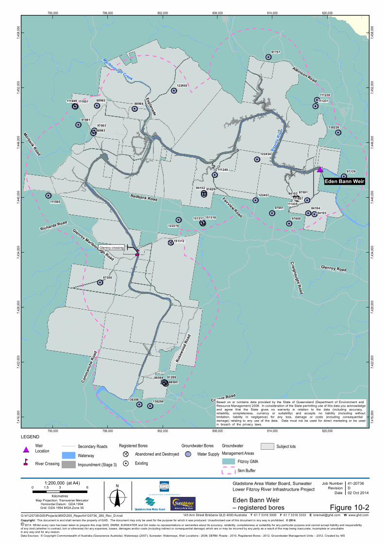
Figure 10-2 and Figure 10-3 show the location of registered groundwater bores within 5 km of the Project
footprint for the Eden Bann Weir and the Rookwood Weir sites, respectively.
The number of registered bores within 5 km of the Project footprint and distance to the nearest registered
bores is shown in Table 10-2.
Table 10-2 Registered bores within proximity to the Project footprint
Registered bores
Eden Bann Weir
5 km Project
footprint
Rookw ood Weir
5 km Project
footprint
No. of registered bores w ithin 5 km 37 66
No. of registered bores on subject lots 21 28
No. of registered bores w ithin the proposed impoundment 0 1 (RN 88940)
Distance to nearest registered bore from the proposed impoundment 400 m (RN 111248) 0 m (RN 88940)
Distance to nearest registered bore from the w eir construction area 2.5 km (RN 97129) 250 m (RN 15128)
Source: DNRM 2013
97651
97650
97591
97550
97129
9700391981
91757
91629
91299
88984
88983
88982
8859588594
84152
8410484103
84102
151318151317
151312
136308 136284
136226
122602
122457
122434
122279
111651111649
111607111585 111435
111248
111231111230
Fitzro
y Rive
r
Eden Bann Weir
Marlborough Creek
Glenroy Road
Atkinson Road
Rose
wood
Road
Comm
anch
e Roa
d
Glenroy Marlborough Road
Redbank Road
Craignaught Road
Fairview Road
Morbank Road
Richards Road
Connor Road
Esplanade
Glenroy crossing
790,000
790,000
796,000
796,000
802,000
802,000
808,000
808,000
814,000
814,000
820,000
820,000
7,416,
000
7,416,
000
7,422,
000
7,422,
000
7,428,
000
7,428,
000
7,434,
000
7,434,
000
7,440,
000
7,440,
000
7,446,
000
7,446,
000
7,452,
000
7,452,
000
7,458,
000
7,458,
000
Figure 10-2G:\41\20736\GIS\Projects\MXD\200_ Report\4120736_ 280_ Rev_ D.m xd
0 3 61.5
Kilom etres
L EGEND
© 2014. Whilst every ca re ha s been ta ken to prepa re this m a p GHD, DNRM, SU NWAT ER a nd GA m a ke no representa tions or wa rra nties a bout its a ccura cy, relia bility, com pleteness or suita bility for a ny pa rticula r purpose a nd ca nnot a ccept lia bility a nd responsibilityof a ny kind (whether in contra ct, tort or otherwise) for a ny expenses, losses, da m a ges a nd/or costs (including indirect or consequentia l da m a ge) which a re or m a y be incurred by a ny pa rty a s a result of the m a p being ina ccura te, incom plete or unsuita blein a ny wa y a nd for a ny rea son.
Job Num berRevision D
41-20736
Da te 02 Oct 2014
Gla dstone Area Wa ter Boa rd, Sunwa terL ower Fitzroy River Infra structure Project
Eden Ba nn Weir – registered bores
Da ta Sources: © Copyright Com m onwea lth of Austra lia (Geoscience Austra lia ): Wa terwa ys (2007); Sunwa ter: Wa terwa ys, Weir L oca tions - 2008; DERM: Roa ds - 2010, Registered Bores - 2012, Groundwa ter Ma na gem ent U nits - -2012. Crea ted by: MS
145 Ann Street Brisba ne QL D 4000 Austra lia T 61 7 3316 3000 F 61 7 3316 3333 E bnem a [email protected] W www.ghd.com
Ma p Projection: T ra nsverse Merca torHorizonta l Da tum : GDA 1994Grid: GDA 1994 MGA Z one 55
Weir Location
River Crossing
Secondary RoadsWaterwayImpoundment (Stage 3)
Registered BoresAbandoned and DestroyedExisting
Groundwater BoresWater Supply
GroundwaterManagement Areas
Fitzroy GMA5km Buffer
Subject lots
1:200,000(a t A4)
Ba sed on or conta ins da ta provided by the Sta te of Queensla nd (Depa rtm ent of Environm ent a nd Resource Ma na gem ent) 2009. In considera tion of the Sta te perm itting use of this da ta you a cknowledgea nd a gree tha t the Sta te gives no wa rra nty in rela tion to the da ta (including a ccura cy, relia bility, com pleteness, currency or suita bility) a nd a ccepts no lia bility (including withoutlim ita tion, lia bility in negligence) for a ny loss, da m a ge or costs (including consequentia l da m a ge) rela ting to a ny use of the da ta . Da ta m ust not be used for direct m a rketing or be usedin brea ch of the priva cy la ws.
Copyright: T his docum ent is a nd sha ll rem a in the property of GHD. T he docum ent m a y only be used for the purpose for which it wa s produced. U na uthorised use of this docum ent in a ny wa y is prohibited. © 2014.
9763397632
97573
97572
9723797236
91771
91769
91741
91736
91735
91679
91646
91639
91636
91635
91396
91395
91004
88940
88903
88902
88901
88867
88855
8871388712
88168
88167
84697
84593
8459267703
67702
67701
67426
67413
151722
151721
151576151286
136150
136144
136143
122447
122330
122302122155
111944
111943
111717
111628
111527
111521
1303043813030803
Dawso
n River
Fitzroy River
Dawson River
Mackenzie River
Enfield Road
Rookwood Road
Hanrahan Road Rosewood Road
Thirs
ty Cr
eek R
oad
Yarra Road
Weir Park Road
Smith Road
Capricorn Highway
Munn
s Roa
d
Gill R
oad
Duaringa-Apis Creek Road
Dono
van R
oad
Ha nra ha n crossing
Riverslea crossing
Foleyva le crossing
91770
67700111716
111627
111629
111520
13030805130308041303080213030801
760,000
760,000
767,500
767,500
775,000
775,000
782,500
782,500
790,000
790,000
797,500
797,500
805,000
805,000
812,500
812,500
820,000
820,000
7,372,
500
7,372,
500
7,380,
000
7,380,
000
7,387,
500
7,387,
500
7,395,
000
7,395,
000
7,402,
500
7,402,
500
Job Num berRevision B
41-20736
G:\41\20736\GIS\Projects\MXD\200_ Report\4120736_ 302_ rev_ b.m xd
Ma p Projection: U niversa l T ra nsverse Merca torHorizonta l Da tum : Geocentric Da tum of Austra lia (GDA94)
Grid: Ma p Grid of Austra lia 1994, Z one 55
0 1.5 3 4.5 6 7.5
Kilom etres
Da te 02 Oct 2014
Gla dstone Area Wa ter Boa rd, SunWa terL ower Fitzroy River Infra structure Project
Rookwood Weir – registered bores
Da ta Sources: © Copyright Com m onwea lth of Austra lia (Geoscience Austra lia ): Wa terwa ys (2007); Sunwa ter: Wa terwa ys, Weir L oca tions - 2008; DERM: Roa ds - 2010, Registered Bores - 2012, Groundwa ter Ma na gem ent U nits - -2012. Crea ted by: MS
L evel 9, 145 Ann St Brisba ne QL D 4000 T 61 7 3316 3000 F 61 7 3316 3333 E bnem a [email protected] .a u W www.ghd.com .a u
Weir Location
River CrossingHighway
Major RoadSecondary RoadsRailwayWaterwayImpoundment (Stage 2)
GroundwaterManagement Areas
Callide GMAFitzroy GMAHighlands GMA
5km BufferSubject lots
Figure 10-3
1:240,000(a t A4)
Ba sed on or conta ins da ta provided by the Sta te of Queensla nd (Depa rtm ent of Environm ent a nd Resource Ma na gem ent) 2013. In considera tion of the Sta te perm itting use of this da ta you a cknowledge a nd a gree tha t the Sta te gives no wa rra nty in rela tion to the da ta (including a ccura cy, relia bility, com pleteness, currency or suita bility) a nd a ccepts no lia bility (including without lim ita tion, lia bility in negligence) for a ny loss, da m a ge or costs (including consequentia l da m a ge) rela ting to a ny use of the da ta . Da ta m ust not be used for direct m a rketing or be used in brea ch of the priva cy la ws.
© 2014. While GHD ha s ta ken ca re to ensure the a ccura cy of this product, GHD, DNRM, SU NWAT ER a nd GA m a ke no representa tions or wa rra nties a bout its a ccura cy, com pleteness or suita bility for a ny pa rticula r purpose. GHD, DNRM, SU NWAT ER a nd GA ca nnot a ccept lia bility of a ny kind (whether in contra ct, tort or otherwise) for a ny expenses, losses, da m a ges a nd/or costs (including indirect or consequentia l da m a ge) which a re or m a y be incurred a s a result of the product being ina ccura te, incom plete or unsuita ble in a ny wa y a nd for a ny rea son.Copyright: T his docum ent is a nd sha ll rem a in the property of GHD. T he docum ent m a y only be used for the purpose for which it wa s produced. U na uthorised use of this docum ent in a ny wa y is prohibited. © 2014.
LEGEND
Registered BoresAbandoned and DestroyedExisting
Groundwater BoresUnknownWater Resources InvestigationWater Supply
Rookwood
10-11 41/20736/10/446834 Draf t environmental impact statement June 2015
Volume 1 Chapter 10 Groundwater resources
Registered bores within 5 km of the Eden Bann Weir Project area comprise the following:
Thirty-six existing bores are registered for water supply
One water supply bore is registered as ‘Abandoned and Destroyed’.
Registered bores within 5 km of the Rookwood Weir Project footprint comprise the following:
Forty-five existing bores are registered for water supply
Three existing bores do not have a defined facility role
Eleven water supply bores are registered as ‘Abandoned and Destroyed’
Six water resource investigation bores are registered as ‘Abandoned and Destroyed’.
One bore registered as ‘Abandoned and Destroyed’ does not have a defined facility role.
No registered bores are located within the proposed Eden Bann Weir impoundment. One registered bore
(RN 88940) is located within the proposed Rookwood Weir impoundment (Stage 1 and Stage 2). RN
88940 is described as a sub-artesian facility, with a water supply role and a maximum yield of 3.8 litres
per second. There is no standing water level information for this bore. The Queensland Groundwater
Database (2009 and 2013) indicates that for bores within 5 km of both the Eden Bann Weir and
Rookwood Weir Project areas groundwater water supply is for stock and domestic use.
DNRM’s groundwater level monitoring network does not include the Fitzroy sub-catchment as
groundwater use is limited. Within the Fitzroy Basin, alluvial aquifers supporting major uses of
groundwater are found in the Don, Dee and Callide Valleys, Boyne Valley, Isaac Catchment, and Sandy
Creek/Neerkol Creek (Gracemere). None of these intercept the area potentially affected by the Project.
Local salinity problems in streams are found in the Wowan area of the Don River, Bell Creek and
Prospect Creek in the Callide Valley, and creeks north of Theodore to Lonesome Creek. The salinity is
associated with groundwater migration as a result of rising water tables, attributed partly to extensive
land clearing in the surrounding areas and partly to overuse of groundwater supplies. As above, none of
these streams are located in proximity to the Project area. As discussed in Chapter 11 Water quality
salinity levels within the Fitzroy, lower Mackenzie and Dawson rivers is not considered problematic and
largely influenced by the naturally saline and alkaline geology of the region. Temporary elevated salinity
levels in rivers have been recorded in association with mine dewatering activities elsewhere in the Fitzroy
Basin.
Groundwater dependent ecosystems 10.2.3
The Atlas of Groundwater Dependent Ecosystems (BoM 2013a) maps groundwater dependent
ecosystems (GDEs) across Australia. BoM (2013b) defines GDEs as ‘natural ecosystems that require
access to groundwater to meet all or some of their water requirements on a permanent or intermittent
basis, so as to maintain their communities of plants and animals, ecosystem processes and ecosystem
services’. Eamus et al. (2006) identifies three key classes of GDEs, these include:
Aquifer and subterranean ecosystems which contain stygofauna. These include karstic, fractured
rock, alluvial aquifers and the zones of saturated sediments within floodplains and river beds
Ecosystems dependent on the surface expression of groundwater, including base flow rivers,
streams, wetlands, some floodplains, mound springs and estuarine seagrass beds
Ecosystems dependent on the subsurface presence of groundwater. These fringing terrestrial
ecosystems, such as Eucalyptus camaldulensis forests and banksia woodlands, access groundwater
resources via their roots in the non-saturated zone located above the water table. Relative
10-12 Draf t environmental impact statement June 2015
Volume 1 Chapter 10 Groundwater resources
41/20736/10/446834
dependency of these communities on groundwater is significantly reduced where depths of
groundwater exceed 10 metres (Eamus et al. 2006).
The Atlas of Groundwater Dependent Ecosystems (BoM 2013a) identifies rivers, springs and wetlands
associated with the Fitzroy, Dawson and Mackenzie rivers as GDEs reliant on the expression of
groundwater. Consistent with Pearce and Hansen (2006) indicating that groundwater flows are towards
the Fitzroy River and groundwater flow in alluvial aquifers essentially follows the surface drainage
gradients, Figure 10-4 shows that for the Eden Bann Weir Project area there is a high potential for
groundwater interaction with rivers, springs and wetlands. For the proposed Rookwood Weir Project area
Figure 10-5 shows there is a moderate potential for groundwater interaction with rivers, springs and
wetlands.
Fringing riparian and floodplain ecosystems, dominated by eucalypts can contain a number of plant
species largely dependent on the availability of groundwater resources to maintain viable populations
(Eamus et al. 2006; Hatton and Evans, 1997). Potential GDEs dependent on the subsurface presence of
groundwater identified within the Eden Bann Weir and Rookwood Weir Project areas include riparian
vegetation dominated by Eucalyptus camaldulensis, E. tereticornis and E. coolabah, consistent with
Regional Ecosystems 11.3.25, 11.3.4 and 11.3.3.
The nearest subterranean GDE recorded on Queensland Government Wetland Info GDE mapping is
approximately 35 km east of Eden Bann Weir (Queensland Government 2013).
Potential impacts and mitigation measures 10.3
Surface waters (such as rivers) commonly interact with groundwater systems. Surface water bodies,
such as rivers, may receive groundwater inflows from groundwater systems impacting on water levels
and water quality within the system. Conversely, surface water systems also have the potential to
recharge groundwater areas and influence groundwater quality.
Extraction of water from rivers can potentially reduce groundwater levels and polluted surface water
systems have the potential to pollute groundwater systems. The converse is also true; extraction of
groundwater may result in reduced surface water flows and polluted groundwater may cause pollution of
surface water systems.
Construction 10.3.1
Construction activities associated with the Project are detailed in Chapter 2 Project description. Activities
with the potential to impact on groundwater resources or uses include the following:
Dewatering of excavations
Extraction of surface water
In-stream diversion of surface water.
A number of potential construction material extraction areas have been identified in close proximity to the
weir construction areas. Subject to further sampling and investigations, separate assessment and
approval of these areas will be sought and they are not included for assessment within the EIS.
Dewatering of excavations will take place during drier periods in accordance with the construction
phases as described in Chapter 2 Project description. As described in Chapter 2 Project description,
excavations are likely to be contained within the shallower, alluvial aquifers. Groundwater in the Project
areas is considered moderate in terms of water quality (section 10.2.1), with the 50th percentile EC in the
order of 2220 µS/cm (Table 10-1) (median in the order of 2,380 µS/cm (Pearce and Hansen 2006)).
PrinchesterCreek
Fitzro
y Rive
r
Eden Bann Weir
Marlborough Creek
Glenroy Road
Atkinson Road
Rose
wood
Road
Comm
anch
e Roa
d
Glenroy Marlborough Road
Redbank Road
Craignaught Road
Fairview Road
Morbank Road
Richards Road
Connor Road
Glenroy crossing
790,000
790,000
796,000
796,000
802,000
802,000
808,000
808,000
814,000
814,000
820,000
820,000
7,416,
000
7,416,
000
7,422,
000
7,422,
000
7,428,
000
7,428,
000
7,434,
000
7,434,
000
7,440,
000
7,440,
000
7,446,
000
7,446,
000
7,452,
000
7,452,
000
7,458,
000
7,458,
000
Figure 10-4G:\41\20736\GIS\Projects\MXD\200_Report\4120736_358_rev_a.mxd
0 3 61.5
Kilometres
LEGEND
© 2014. Whilst every care has been taken to prepare this map GHD, DNRM, SUNWATER, GA and BOM make no representations or warranties about its accuracy, reliability, completeness or suitability for any particular purpose and cannot accept liability and responsibilityof any kind (whether in contract, tort or otherwise) for any expenses, losses, damages and/or costs (including indirect or consequential damage) which are or may be incurred by any party as a result of the map being inaccurate, incomplete or unsuitablein any way and for any reason.
Job NumberRevision A
41-20736
Date 30 Oct 2014
Gladstone Area Water Board, SunwaterLower Fitzroy River Infrastructure Project
Eden Bann Weir groundwater dependent ecosystems
Data Sources: © Copyright Commonwealth of Australia (Geoscience Australia): Waterways (2007); Sunwater: Waterways, Weir Locations - 2008; DERM: Roads - 2010, HES Wetlands - 2012; BOM: GDE - 2013. Created by: MS
145 Ann Street Brisbane QLD 4000 Australia T 61 7 3316 3000 F 61 7 3316 3333 E [email protected] W www.ghd.com
Map Projection: Transverse MercatorHorizontal Datum: GDA 1994Grid: GDA 1994 MGA Zone 55
Weir Location
River CrossingSecondary Roads
Impoundment (Stage 3)WaterwayHigh EcologicalSignificance Wetlands
Groundwater Dependent EcosystemsReliant on surface expression of groundwater (river, springs, wetlands)
High potential for groundwater interactionModerate potential for groundwater interactionLow potential for groundwater interaction
Reliant on subsurface groundwater (vegetation)High potential for groundwater interactionModerate potential for groundwater interactionLow potential for groundwater interaction
1:200,000 (at A4)
Based on or contains data provided by the State of Queensland (Department of Environment and Resource Management) 2009. In consideration of the State permitting use of this data you acknowledgeand agree that the State gives no warranty in relation to the data (including accuracy, reliability, completeness, currency or suitability) and accepts no liability (including withoutlimitation, liability in negligence) for any loss, damage or costs (including consequential damage) relating to any use of the data. Data must not be used for direct marketing or be usedin breach of the privacy laws.
Copyright: This document is and shall remain the property of GHD. The document may only be used for the purpose for which it was produced. Unauthorised use of this document in any way is prohibited. © 2014.
Fitzroy River
Thirs
tyCr
eekR
oad
Dawso
n River
Mackenzie River
Enfield Road
Rookwood Road
Hanrahan Road Rosewood Road
Yarra Road
Weir Park Road
Capricorn Highway
Munn
s Roa
d
Gill R
oad
Duaringa-Apis Creek Road
Dono
van R
oad
Ohio Road
Riverslea crossing
Foleyvale crossing
Hanrahan crossing
760,000
760,000
767,500
767,500
775,000
775,000
782,500
782,500
790,000
790,000
797,500
797,500
805,000
805,000
812,500
812,500
820,000
820,000
7,372,
500
7,372,
500
7,380,
000
7,380,
000
7,387,
500
7,387,
500
7,395,
000
7,395,
000
7,402,
500
7,402,
500
Job NumberRevision A
41-20736
G:\41\20736\GIS\Projects\MXD\200_Report\4120736_357_rev_a.mxd
Map Projection: Universal Transverse MercatorHorizontal Datum: Geocentric Datum of Australia (GDA94)
Grid: Map Grid of Australia 1994, Zone 55
0 1.5 3 4.5 6 7.5
Kilometres
Date 30 Oct 2014
Gladstone Area Water Board, SunWaterLower Fitzroy River Infrastructure Project
Rookwood Weir groundwater dependent ecosystems
Data Sources: © Copyright Commonwealth of Australia (Geoscience Australia): Waterways (2007); Sunwater: Waterways, Weir Locations - 2008; DERM: Roads - 2010, HES Wetlands - 2012; BOM: GDE - 2013. Created by: MS
Level 9, 145 Ann St Brisbane QLD 4000 T 61 7 3316 3000 F 61 7 3316 3333 E [email protected] W www.ghd.com.au
WeirLocation
River CrossingHighway
Major RoadSecondary RoadsRailwayWaterway
Impoundment (Stage 2)High EcologicalSignificance Wetlands Figure 10-5
1:240,000 (at A4)
Based on or contains data provided by the State of Queensland (Department of Environment and Resource Management) 2013. In consideration of the State permitting use of this data you acknowledge and agree that the State gives no warranty in relation to the data (including accuracy, reliability, completeness, currency or suitability) and accepts no liability (including without limitation, liability in negligence) for any loss, damage or costs (including consequential damage) relating to any use of the data. Data must not be used for direct marketing or be used in breach of the privacy laws.
© 2014. While GHD has taken care to ensure the accuracy of this product, GHD, DNRM, SUNWATER, GA and BOM make no representations or warranties about its accuracy, completeness or suitability for any particular purpose. GHD, DNRM, SUNWATER and GA cannot accept liability of any kind (whether in contract, tort or otherwise) for any expenses, losses, damages and/or costs (including indirect or consequential damage) which are or may be incurred as a result of the product being inaccurate, incomplete or unsuitable in any way and for any reason.Copyright: This document is and shall remain the property of GHD. The document may only be used for the purpose for which it was produced. Unauthorised use of this document in any way is prohibited. © 2014.
LEGEND
Groundwater Dependent EcosystemsReliant on surface expression of groundwater(river, springs, wetlands)
High potential for groundwater interactionModerate potential for groundwater interactionLow potential for groundwater interaction
Reliant on subsurface groundwater (vegetation)High potential for groundwater interactionModerate potential for groundwater interactionLow potential for groundwater interaction
Rookwood
10-15 41/20736/10/446834 Draf t environmental impact statement June 2015
Volume 1 Chapter 10 Groundwater resrouces
Groundwater extracted as part of this dewatering will be stored temporarily in a sediment basin and
released to the existing channel of the Fitzroy River once it is demonstrated that the water quality is
suitable for release. It is considered that recharge is likely due to the proximity of the point of release and
the point of groundwater extraction. It is not expected that drawdown as a result of dewatering will be
significant.
Water supply for the Project will be achieved through surface water extraction immediately upstream of
the construction site (Chapter 2 Project description). Surface water will be extracted in accordance with a
permit acquired under the Water Act 2000 (Qld) and will therefore be consistent with the environmental
flow objectives of the Fitzroy WRP. Groundwater extraction is not proposed for the purpose of water
supply. It is considered that drawdown as a result of the extraction of surface water will not be significant.
The construction of the Project will involve diversion of surface water within existing channels and will not
require the impoundment of water within a watercourse. As surface water will be diverted within the
existing channel, this activity is not expected to affect groundwater recharge.
Groundwater quality has the potential to be impacted by unsuitable storage and spillage of chemicals,
fuels and waste products during construction. With appropriate management measures in place and
compliance with relevant guidelines (as described in the Chapter 23 Environmental management plan), it
is considered that the potential for groundwater contamination is negligible.
Construction of the Project will not directly impact groundwater infrastructure as there are no registered
bores within the construction areas. There is low potential for groundwater drawdown as a result of
construction the Project. As such, no indirect impacts on groundwater infrastructure (reduced availability)
are expected.
The construction phase is anticipated to have very little effect on groundwater dependant ecosystems
within the area, due to the established low potential for drawdown associated with construction of the
Project.
Operations 10.3.2
Groundwater impacts during operations can be broadly divided into two categories:
Upstream impacts: Impacts caused by inundation of river bed and bank areas upstream of the
proposed weirs. Inundation has the potential to cause damage to GDEs and impact water users
through inundation of groundwater infrastructure
Downstream impacts: Impacts caused by altered river flow regimes. A reduced river flow has the
potential to reduce groundwater recharge and therefore groundwater levels which has the potential
to impact GDEs and other groundwater users.
Upstream impacts 10.3.2.1
Salinisation
There are a number of mechanisms by which groundwater salinisation could occur as a result of the
inundation. These include:
Increased recharge leading to leaching of saline soil water towards fresher groundwater
Rising water tables causing groundwater to be mixed with more saline soil water.
It is not expected that groundwater salinisation will occur for the following reasons:
10-16 Draf t environmental impact statement June 2015
Volume 1 Chapter 10 Groundwater resources
41/20736/10/446834
There are no known existing outbreaks of salinity in the Project Area. It is noted that Eden Bann Weir
was constructed in 1994 (some 20 years ago) and there is no evidence of salinisation associated
with the impoundment
There will be no vegetation clearing which could lead to salinisation
No salinity outbreaks are expected as a result of inundation of the water storage areas
Groundwater flows within the Fitzroy River-sub-catchment trends towards flows into the Fitzroy
River.
During operations, the inundation area and immediate surrounds will be monitored to detect any
instances of erosion, salinity, or other landscape instability so that any necessary remedial work can be
arranged.
Groundwater infrastructure
The operation of the proposed Rookwood Weir (Stage 1 and Stage 2) will result in the inundation of one
existing bore (Section 10.2.2). Consultation with the landholder will be undertaken to enter into an
agreement on measures to restore the loss of supply or provision of alternative compensatory measures
as agreed between the parties as relevant and applicable.
No existing groundwater bores will be directly impacted as a result of raising Eden Bann Weir.
Local groundwater levels and recharge
Inundation as a result of the Project will increase from the existing (Stage 1) 670 ha to 1,690 ha at Eden
Bann Weir (Stage 3) and will cover 1,930 ha at Rookwood Weir (Stage 2).
Given the downward gradient from surface water to groundwater and presence of the impounded water,
recharge to the underlying alluvium and fractured bedrock aquifers beneath the two inundated reaches is
anticipated to increase in comparison to existing conditions and localised groundwater levels (i.e.
beneath and in the immediate vicinity of the channel) are anticipated to rise as a result. At Eden Bann
Weir there is the potential for the localised groundwater levels to increase to around 20.2 m AHD (gated
spillway level, Stage 3) and at Rookwood Weir to increase to around 49 m AHD (gated spillway level,
Stage 2), however these levels remain well below the respective river bank elevations of between around
25 m and 30 m AHD at Eden Bann Weir and around 56 to 58 m AHD at Rookwood Weir. Such
groundwater levels are unlikely to be maintained for any significant length of time however, as the stored
water behind the weirs is gradually released throughout the year.
Groundwater dependant ecosystems
The increase in inundation and likely associated rise in the groundwater table beneath and in the
immediate vicinity of the river channel (discussed in the above paragraph) could potentially lead to
waterlogging of the root zone in the riparian area outside of the inundated zone and associated dieback.
Potential GDEs dependent on the subsurface presence of groundwater identified within the Eden Bann
Weir and Rookwood Weir Project areas include riparian vegetation dominated by Eucalyptus
camaldulensis, E. tereticornis and E. coolabah, consistent with Regional Ecosystems 11.3.25, 11.3.4 and
11.3.3.
Riparian vegetation and GDEs inundated within the bed and banks of the Fitzroy, Mackenzie and
Dawson rivers will be subject to dieback. The increase in inundation and likely associated rise in the
groundwater table beneath and in the immediate vicinity of the river channel (discussed in the above
10-17 41/20736/10/446834 Draf t environmental impact statement June 2015
Volume 1 Chapter 10 Groundwater resources
subsection) could potentially lead to waterlogging of the root zone of the riparian area outside of the
inundated zone and associated dieback.
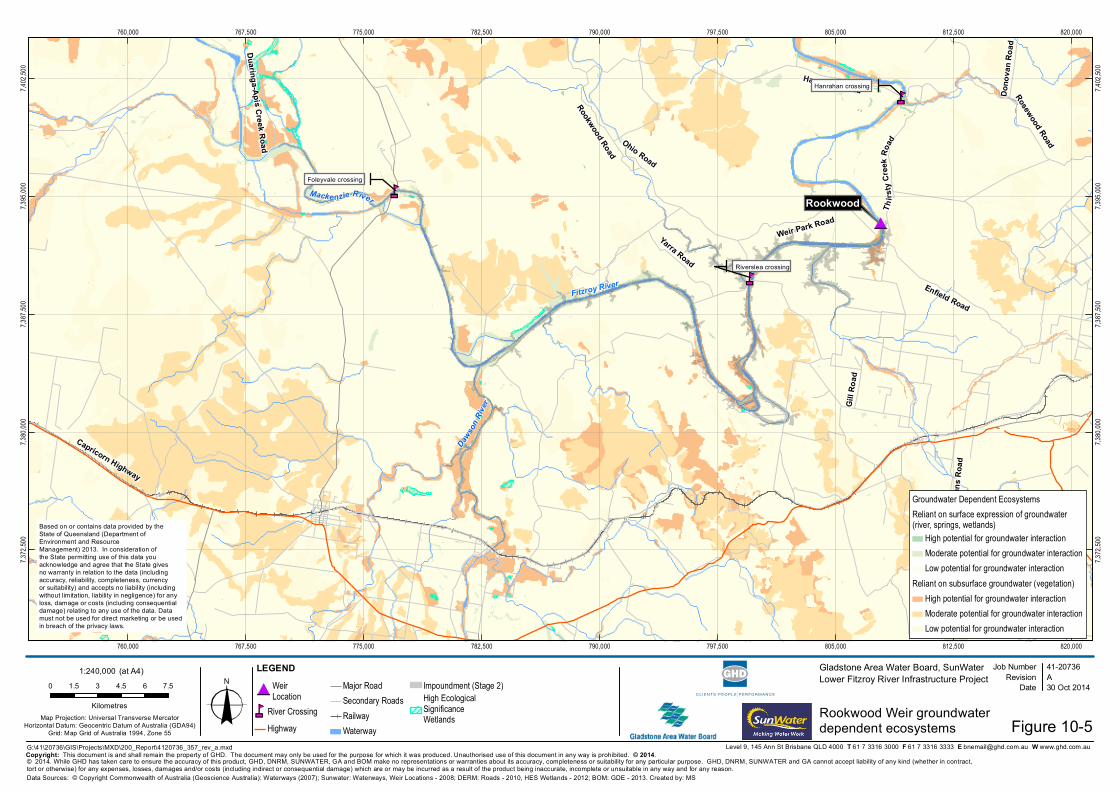
Upstream of the proposed Rookwood Weir Stage 2 impoundment (at 334 km AMTD) there is a Great
Barrier Reef wetland protection area/wetland of high ecological significance located between 100 m and
350 m from the upstream limit on the Mackenzie River (Figure 10-5). This wetland is not listed as a GDE
on the Queensland Government Wetland Info. For the proposed Rookwood Weir Project area Figure
10-5 shows there is a moderate potential for groundwater interaction with rivers, springs and wetlands.
The Stage 2 Rookwood Weir impoundment is not expected to inundate the identified wetland areas. Any
rise in the groundwater table associated with the impoundment is anticipated to be minimal at and in the
vicinity of the upstream limit of the impoundment, as the surface water level and hence hydraulic gradient
to the underlying strata should not be significantly different to pre-construction conditions. No significant
impact to the Great Barrier Reef wetland protection area is therefore anticipated.
Downstream impacts 10.3.2.2
Local groundwater levels and recharge
Flow in the river is the predominant mechanism for the recharge of groundwater and for the maintenance
of groundwater levels and flows in the immediate vicinity of the Fitzroy River. Given that no significant
differences between pre and post-development modelled flows are predicted downstream of Eden Bann
Weir and Rookwood Weir (Chapter 9 Surface water resources), no significant reduction in the existing
groundwater levels or in the existing recharge to groundwater provided by the Fitzroy River channel
downstream of the structures is anticipated. This is supported by the following:
Analysis of modelled flows for locations upstream, within and downstream of the Project (IQQM1 end
of system, IQQM2 at Wattlebank (downstream of Eden Bann Weir), IQQM3 The Gap (~1 km
upstream of Eden Bann Weir), IQQM4 (downstream of Rookwood Weir and upstream of Eden Bann
Weir impoundment) and OQQM5 at Riverslea (~11 km upstream of Rookwood Weir)) predicts no
significant differences between the current modelled flow regimes (with the existing Eden Bann Weir
(base case)) and the projected flow regimes for any of the proposed additional infrastructure (Eden
Bann Weir Stage 2 and Stage 3, Rookwood Weir Stage 1 and Stage 2). The results of the modelling
are discussed in detail in Chapter 9 Surface Water Resources and the hydrographs and flow duration
curves are presented in Appendix P. For the final development scenario (completed Eden Bann
Stage 3 and Rookwood Weir Stage 2) at IQQM4 (downstream of Rookwood Weir) and at IQQM2
(Wattlebank downstream of Eden Bann Weir):
– The hydrographs of modelled streamflow show no significant difference in the pattern of monthly
flows for the final development scenario in comparison to the existing scenario (base case).
– The flow duration curves of modelled streamflow under the final development scenario show flows
are maintained for longer in comparison to the existing (base case) scenario. The flow duration
curves for IQQM4 (downstream of Rookwood Weir) predict just under 90% of days with flows
greater than 100ML/day under the final development scenario in comparison to around 65% of
days under the existing scenario (base case). The flow duration curves for IQQM2 (Wattlebank
downstream of Eden Bann Weir) predict just over 90% of days with flows greater than 100ML/day
under the final development scenario in comparison to around 70% of days under the existing
scenario (base case).
Release of water from the Eden Bann Weir and the proposed Rookwood Weir will be made in
accordance with environmental flow objectives (EFOs) and water allocation security objectives
(WASOs) defined in the Fitzroy ROP. Environmental flow objectives will be established to maintain
10-18 Draf t environmental impact statement June 2015
Volume 1 Chapter 10 Groundwater resources
41/20736/10/446834
base flow (a daily release) and first wet season flow, among other flow characteristics. Water
releases are designed to mimic the natural system and therefore assist in maintaining recharge to
groundwater downstream. The environmental flow objectives will be set in accordance with the
Fitzroy WRP, and in consultation with the Department of Environment and Heritage Protection and
the Department of natural Resources and Mines. It is therefore considered that the Fitzroy ROP will
achieve the general ecological outcomes under Clause 14 of the Fitzroy WRP, including the
maintenance of groundwater recharge beneath the river channel.
The potential for a reduction in groundwater levels at existing registered bores located downstream of the
weirs as a result of the Project is considered negligible.
Groundwater dependant ecosystems
The nearest subterranean GDE recorded on Queensland Government Wetland Info GDE mapping is
approximately 35 km east of Eden Bann Weir (Queensland Government 2013). Figure 10-4 shows that
downstream of the Eden Bann Weir and Rookwood Weir there is a high potential for groundwater
interaction in relation to rivers, springs and wetlands and in relation to vegetation reliant on sub surface
groundwater. There are also potential GDEs associated with riparian vegetation dominated by
Eucalyptus camaldulensis, E. tereticornis and E. coolabah, consistent with Regional Ecosystems
11.3.25, 11.3.4 and 11.3.3.
It is demonstrated that environmental flows will be maintained and no significant reduction in the existing
groundwater levels or in the existing recharge to groundwater provided by the Fitzroy River channel
downstream of Eden Bann Weir or Rookwood Weir is anticipated. No significant impacts to potential
GDEs downstream of either structure are therefore anticipated.
Summary 10.4
Impacts on groundwater levels and recharge to groundwater as a result of the Project construction and
operation are considered likely to be negligible. Groundwater beneath and in the near vicinity of the
Fitzroy River will continue to be recharged via seepage through the river channel bed, as flows will be
maintained during construction and operational water releases are designed to mimic the natural system
as far as possible, whilst direct infiltration of rainfall remains the predominant recharge mechanism away
from the river. An increase in recharge and groundwater levels is possible beneath and in the immediate
vicinity of the impoundments. However, the volume of additional recharge to the system overall is not
expected to be significantly different to existing conditions given the volumes of water within the river
system are essentially remaining the same as pre-development conditions.
Groundwater quality within the Fitzroy River sub-catchment is slightly to moderately saline. It is not
expected that groundwater salinisation will occur as a result of the Project.
The potential for a reduction in groundwater levels at existing registered bores located downstream of the
weirs as a result of the Project is considered negligible due to the maintenance of environmental flow
objectives of the Fitzroy WRP and hence maintenance of aquifer recharge beneath and in the immediate
vicinity of the river as a result.
The Project will have negligible effects on groundwater dependant ecosystems outside of the bed and
banks of the Fitzroy, Mackenzie and Dawson rivers’ inundation areas.
In relation to effects on groundwater infrastructure a single bore will be inundated at Rookwood Weir
Stage 1 and Stage 2 in association with the operation of the Project.