Granite (Building Stone) Quarry owned by Mohammed.K, at Vazhzkkad Village, Kondotty Taluk & Malappuram District – Extent 2.2092 Ha` PRE-FEASIBILTY REPORT 1.0 INTRODUCTION OF THE MINING ACTIVITY Mohammed.K is proposing an existing Granite (Building Stone) Quarry with Lease at Re-Survey Nos. 36/2, 37 & 38/1 of Vazhakkad Village, Kondotty Taluk, Malappuram District, Kerala in an extent area of 2.2092 hectares. The proposed quarry area is privately owned rocky land. The proposed quarry area is located at Vazhakkad, 13 km from Feroke and 28 km from Malappuram . The topography of the surrounding lease area is an elevated terrain with quarry land covered with native trees, shrubs, herbs, grass, climbers, bushes etc. Small Part of the proposed land is already under mining and there is no vegetation in that area. The highest elevation of the lease area is 110 m MSL and lowest is 35 m MSL. As the proposed area is hillock, the drainage of the lease area is towards North-West direction. No habitants are located in the lease area. The geological resources of Granite (Building Stone) in mining lease area are estimated to be 1673474 MT. In the first five years of plan period total 3,30,000 MT Granite (Building Stone) shall be quarried/mined. The balance mineral reserves and part of blocked resources shall be quarried after modifying the bench design in next five year period.The average annual rainfall of the district is 2952 mm. Out of this, major rainfall contribution is from SW monsoon followed by the NE.The anticipated life of the quarry is 12 years expected. 1.1 LOCATION OF THE PROPOSED PROJECT The proposed quarry area is located at Vazhakkad, 13 km from Feroke and 28 km from Malappuram.The topography of the surrounding lease area is an elevated terrain with quarry land covered with native trees, shrubs, herbs, grass, climbers, bushes etc. Small Part of the proposed land is already under mining and there is no vegetation in that area.The highest elevation of the lease area is 110 m MSL and lowest is 35 m MSL. As the
Transcript
Granite (Building Stone) Quarry owned by Mohammed.K, at Vazhzkkad Village, Kondotty Taluk & Malappuram District – Extent 2.2092 Ha`
PRE-FEASIBILTY REPORT
1.0 INTRODUCTION OF THE MINING ACTIVITY
Mohammed.K is proposing an existing Granite (Building Stone) Quarry with
Lease at Re-Survey Nos. 36/2, 37 & 38/1 of Vazhakkad Village, Kondotty Taluk,
Malappuram District , Kerala in an extent area of 2.2092 hectares. The proposed
quarry area is privately owned rocky land.
The proposed quarry area is located at Vazhakkad, 13 km from Feroke
and 28 km from Malappuram . The topography of the surrounding lease area
is an elevated terrain with quarry land covered with native trees, shrubs, herbs,
grass, climbers, bushes etc . Small Part of the proposed land is already under
mining and there is no vegetation in that area. The highest elevation of the
lease area is 110 m MSL and lowest is 35 m MSL. As the proposed area is
hillock, the drainage of the lease area is towards North-West direction. No
habitants are located in the lease area.
The geological resources of G ranite (Building Stone) in mining lease area
are estimated to be 1673474 MT. In the first five years of plan period total
3,30,000 MT Granite (Building Stone) shall be quarried/mined. The balance
mineral reserves and part of blocked resources shall be quarried after
modifying the bench design in next five year period .The average annual rainfall
of the district is 2952 mm. Out of this, major rainfall contribution is from SW
monsoon followed by the NE.The anticipated life of the quarry is 12 years
expected.
1.1 LOCATION OF THE PROPOSED PROJECT
The proposed quarry area is located at Vazhakkad, 13 km from Feroke and
28 km from Malappuram.The topography of the surrounding lease area is
an elevated terrain with quarry land covered with native trees, shrubs,
herbs, grass, climbers, bushes etc . Small Part of the proposed land is
already under mining and there is no vegetation in that area .The highest
elevation of the lease area is 110 m MSL and lowest is 35 m MSL. As the
Granite (Building Stone) Quarry owned by Mohammed.K, at Vazhzkkad Village, Kondotty Taluk & Malappuram District – Extent 2.2092 Ha`
proposed area is hillock, the drainage of the lease area is towards North-
West direction. No habitants are located in the lease area.
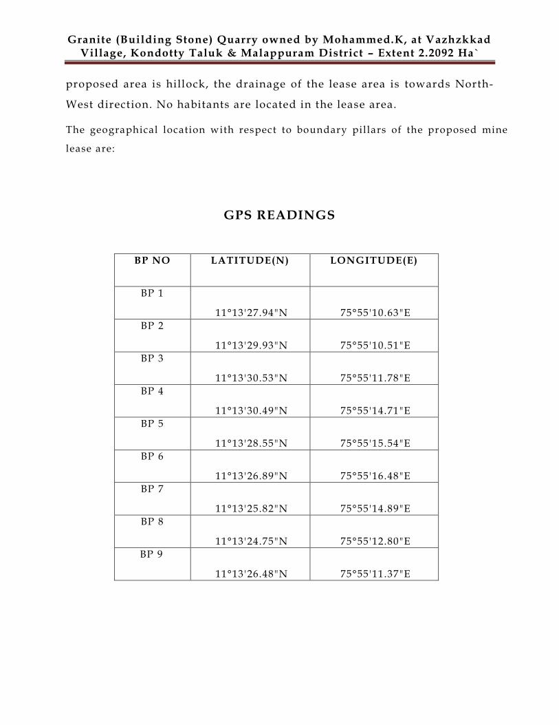
The geographical location with respect to boundary pillars of the proposed mine
lease are:
GPS READINGS
BP NO LATITUDE(N) LONGITUDE(E)
BP 1
11°13'27.94"N 75°55'10.63"E
BP 2
11°13'29.93"N 75°55'10.51"E
BP 3
11°13'30.53"N 75°55'11.78"E
BP 4
11°13'30.49"N 75°55'14.71"E
BP 5
11°13'28.55"N 75°55'15.54"E
BP 6
11°13'26.89"N 75°55'16.48"E
BP 7
11°13'25.82"N 75°55'14.89"E
BP 8
11°13'24.75"N 75°55'12.80"E
BP 9
11°13'26.48"N 75°55'11.37"E
Granite (Building Stone) Quarry owned by Mohammed.K, at Vazhzkkad Village, Kondotty Taluk & Malappuram District – Extent 2.2092 Ha`
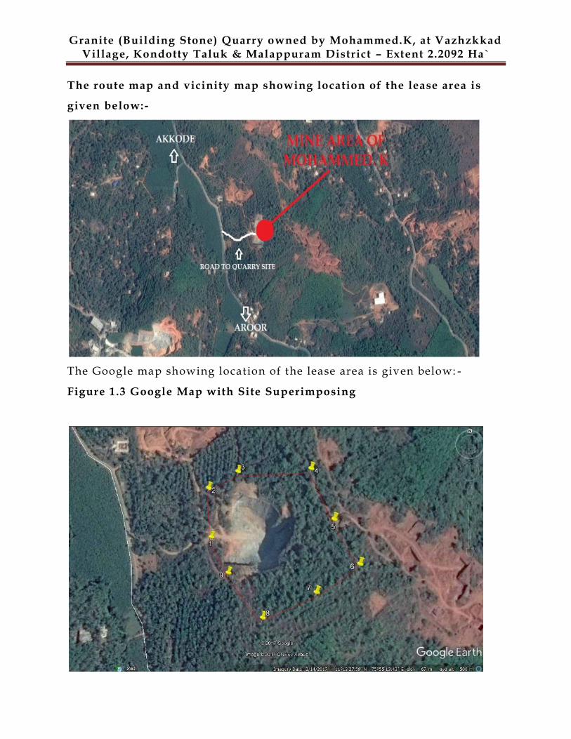
The route map and vicinity map showing location of the lease area is
given below:-
The Google map showing location of the lease area is given below: -
Figure 1.3 Google Map with Site Superimposing
Granite (Building Stone) Quarry owned by Mohammed.K, at Vazhzkkad Village, Kondotty Taluk & Malappuram District – Extent 2.2092 Ha`
1.3 NEED FOR THE PROJECT AND ITS IMPORTANCE TO THE COUNTRY OR
REGION
The major essentiality of building stone is based on its extraordinary compressive strength
and durability (among the hardest, dimensional & structural stones) and it is having high
tolerance towards the vagaries of nature. In construction activities these are being used because of
its hardness & density, durability and strength craft
The employment opportunities are being created in connecting with the quarrying activities
and the local people are being employed for the non technical activities under the direction of
mining engineers and supervisors. For the quarry operations, more than 12 employees are being
deployed which generates ample opportunities for those people directly and indirectly.
Besides,CSR activities of the project proponent will bring about improvement in infrastructure,
living conditions of local community etc.
Applicant will pay royalty for the mineral produced from the mine, direct and indirect taxes
will be paid thereby contributing to the regional revenue. The public revenue will further be put for
infrastructural development and other sectors like health, education and social welfare.
1.4 END USE (DOMESTIC/ EXPORT MARKET)
The material produced from the quarry is sold to the contractors and to
the consumers which is finally consumed locally for road (State Highway &
National Highway) & building construction works. Fine Material is also sold to
the hollow block/ solid block manufactu res. The quarry output, i .e . Granite
Granite (Building Stone) Quarry owned by Mohammed.K, at Vazhzkkad Village, Kondotty Taluk & Malappuram District – Extent 2.2092 Ha`
(Building Stone) from the proposed quarry owned by Mohammed.K will
transported to the crusher unit for the production of different sizes of granite
aggregates outside the quarry lease area and also to the consuming centers for
various needs such as construction of roads, bridges, buildings etc., in the nearby
areas.
2.0 PROJECT DESCRIPTION
2.1 SALIENT FEATURES & ENVIRONMENTAL SETTING OF THE
PROJECT
Particulars Details
Total Mine Lease area 2.2092 hectares
Total area owned by the
proponent
Privately owned and lease land
Current status of the
quarry
Operational Quarry
Local name of the project
area
(Name of the hill)
Akkode
Production The geological reserves of Granite (Building
Stone) in mining lease area are estimated to be
1673474 MT and production / mineable reserves
are 793357 MT. In the first year of plan period
total 66,000 MT Granite (Building Stone) shall be
quarried/mined. The balance mineral reserves
and part of blocked resources shall be quarried
after modifying the bench design in next five
year period
Life of Mine 12 Years
Estimated project cost Rs. 30 lakhs
Man Power 12 persons (on permanent / contract basis)
Granite (Building Stone) Quarry owned by Mohammed.K, at Vazhzkkad Village, Kondotty Taluk & Malappuram District – Extent 2.2092 Ha`
Highest and lowest
elevation
110 m MSL & 35 m MSL
Land use Private Rocky Land
Nearest habitation 112.1 m
Nearest town Akkode, 2 km
Stone Crusher & M Sand Nil
Width of access road to the
quarry site
Akkode-Aroor Road, 6 m
Nearest Airport Calicut International Airport – 20 km.
Nearest Highway Kozhikode – Palakkad (NH – 213), 10 km
Nearest Railway Station Feroke Railway Station , 12 km
Details of nearby quarry /
crusher
High Grip Granites,Vazhayoor
Power supply Nil
Water and its Source
The entire water for industrial activities such as
Dust suppression, greenbelt plantations will be
sourced from open well .
Domestic consumption : 0.5 KLD
Dust suppression : 1 KLD
Plantation : 1 KLD
TOTAL : 2.5KLD
Nearest Govt. Hospital /
dispensary
General Hospital, Vazhakkad , 6 km
Education facility Shafi College, Vazhayur , 3 km
Fire Station Meenchantha-Calicut Fire Station, 20 km
Ambulance Vazhakkad,6 km
Police Station Vazhakkad Police Station, 7 km
Granite (Building Stone) Quarry owned by Mohammed.K, at Vazhzkkad Village, Kondotty Taluk & Malappuram District – Extent 2.2092 Ha`
Church / temple / mosque
None within 500 m radius
Electrical installation like
transformer /HT l ine or
LT line
Akkode, 150 m
Mobile Towers None within 500 m radius
Defense installations None within 500 m radius
Archeological Features None within 500 m radius
Ecological sensitive zones None within 500 m radius
Nearest Forests None within 500 m radius
Nearest streams/ rivers/
water bodies (from mine
boundary)
Nil
Seismic zone Zone-III , Moderate damage risk zone as par
BMTPC, Vulnerability atlas Seismic zone of India
IS: 1893-2002.
Categorization as per
WGEEP Report
As per WGEEP classification, the project site is
not located in the vicinity of protected area
2.2 PHYSIOGRAPHY / TOPOGRAPHY / DRAINAGE PATTERN
The physiography of the quarry area is a part of elevated terrain. The
topography of the lease area is hilly terrain with Granite (Building S tone)
deposit. The highest elevation of the lease area is 110 m MSL and lowest is 35 m
MSL. The topographic / surface plan on 1:1500 scale incorporates all the
existing details like topography, surface exposures, structures etc. and is
enclosed in the Mining plan.
2.3 LEASEHOLD AREA
The quarry site covers the mining area of 2.2092 Ha which is a private rocky land.
Granite (Building Stone) Quarry owned by Mohammed.K, at Vazhzkkad Village, Kondotty Taluk & Malappuram District – Extent 2.2092 Ha`
The lease area does not comprise of any protected or reserved forest lands. Ecologically sensitive
features like national parks, biospheres, sanctuaries, elephant corridors, Tiger reserves, flight paths
of migrating fauna, etc., are also not visible in this vicinity of core zone.
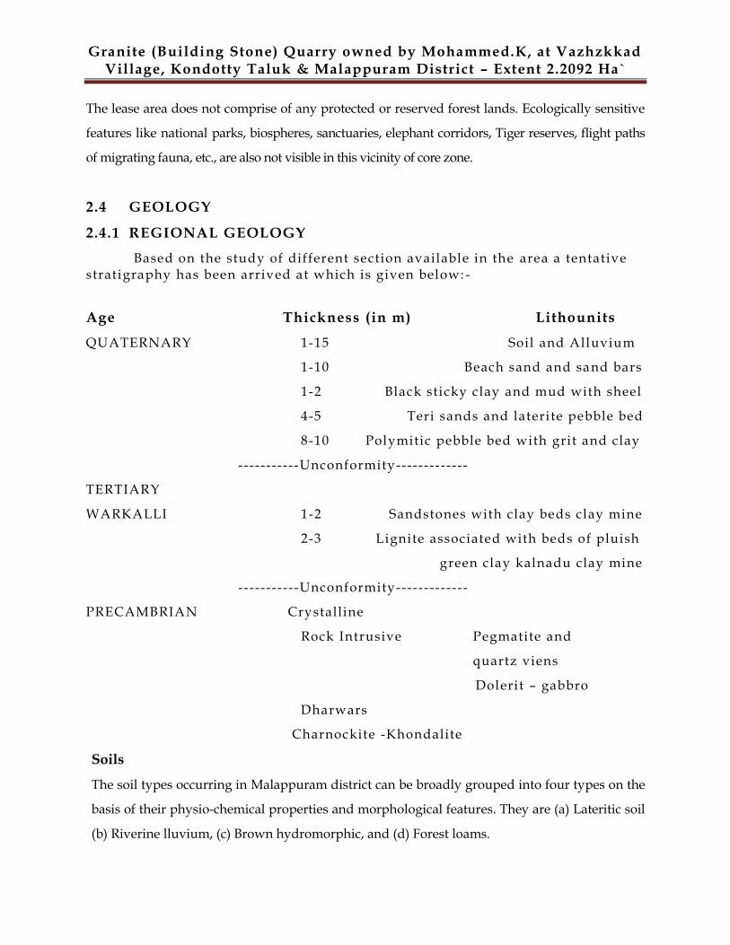
2.4 GEOLOGY
2.4.1 REGIONAL GEOLOGY
Based on the study of different section available in the area a tentative stratigraphy has been arrived at which is given below: -
Age Thickness (in m) Lithounits
QUATERNARY 1-15 Soil and Alluvium
1-10 Beach sand and sand bars
1-2 Black sticky clay and mud with sheel
4-5 Teri sands and laterite pebble bed
8-10 Polymitic pebble bed with grit and clay
-----------Unconformity-------------
TERTIARY
WARKALLI 1-2 Sandstones with clay beds clay mine
2-3 Lignite associated with beds of pluish
green clay kalnadu clay mine
-----------Unconformity-------------
PRECAMBRIAN Crystalline
Rock Intrusive Pegmatite and
quartz viens
Dolerit – gabbro
Dharwars
Charnockite -Khondalite
Soils
The soil types occurring in Malappuram district can be broadly grouped into four types on the
basis of their physio-chemical properties and morphological features. They are (a) Lateritic soil
(b) Riverine lluvium, (c) Brown hydromorphic, and (d) Forest loams.
Granite (Building Stone) Quarry owned by Mohammed.K, at Vazhzkkad Village, Kondotty Taluk & Malappuram District – Extent 2.2092 Ha`
2.4.2 LOCAL GEOLOGY
The local geology belongs to the regional geology. Main rock type in the study
area is charnockite. At places where they are exposed, the charnockite is
medium to coarse grained with dark grey quartz. The soil & over burden
thickness varies from avg. 0.9 m. to 1.2 m. topographically , the area is
undulating.
A geological plan showing the granites and soil cover and the geological
sections showing subsurface geology is prepared on 1:15 00 scale.
Local Geology
Top Soil (thickness in m) 0.9
Over Burden (thickness in m) 1.2
The local geology belongs to the regional geology. In the lease area, the granite
occurs as massive consolidated formation. The geological plan of the area is
prepared and attached. Geological cross sections have been drawn at fixed
intervals across the lease area in Plate No. 3 . The section line along which the
geological sections have been prepared which has been shown in Plate No. 3.
The Sections has been drawn across the strike of the host ro ck.
2.5 MINEABLE RESERVES
In this area the building stone exposures are bordering to the lease boundary.
The mineable reserves are arrived after deducting the reserves locked in mines
safety slope along with boundary in compliance with mineral concession rules.
The quantity of such kind of reserves is arrived as following: -
SECTION BLOCKED RESERVE (MT)
MINEABLE RESERVE (MT)
GEOLOGICAL RESERVE (MT)
A-A1 270060 171132 441192
B-B1 199677 138065 337742
C-C1 410380 484160 894540
Granite (Building Stone) Quarry owned by Mohammed.K, at Vazhzkkad Village, Kondotty Taluk & Malappuram District – Extent 2.2092 Ha`
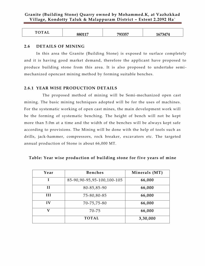
TOTAL 880117 793357 1673474
2.6 DETAILS OF MINING
In this area the Granite (Building Stone) is exposed to surface completely
and it is having good market demand, therefore the applicant have proposed to
produce building stone from this area. It is also proposed to undertake semi -
mechanized opencast mining method by forming suitable benches.
2.6.1 YEAR WISE PRODUCTION DETAILS
The proposed method of mining will be Semi -mechanized open cast
mining. The basic mining techniques adopted will be for the uses of machines.
For the systematic working of open cast mines, the main development work will
be the forming of systematic benching. The height of bench will not be kept
more than 5.0m at a time and the width of the benches will be always kept safe
according to provisions. The Mining will be done with the help of tools such as
drills, jack-hammer, compressors, rock breaker , excavators etc. The targeted
annual production of Stone is about 66,000 MT.
Table: Year wise production of building stone for five years of mine
Year Benches Minerals (MT)
I 85-90,90-95,95-100,100-105 66,000
II 80-85,85-90 66,000
III 75-80,80-85 66,000
IV 70-75,75-80 66,000
V 70-75 66,000
TOTAL 3,30,000
Granite (Building Stone) Quarry owned by Mohammed.K, at Vazhzkkad Village, Kondotty Taluk & Malappuram District – Extent 2.2092 Ha`
2.6.2 PROPOSED METHOD OF MINING
It is proposed to undertake Open Cast Semi-Mechanized Mining Method.
2.6.2.1 Open Cast mining
The mining will be done by open cast semi -mechanized method of mining. The
excavation of mineral is proposed by excavators. The mineral is fractured and
easily exploitable by rock breakers and excavators. The hard strata are
proposed to excavate after drilling and blasting. The height of bench will not be
kept more than 5.0m at a time and the width of the benches will be always kept
safe according to provisions. The Mining will be done with the help of tools
such as drills, jack-hammer, compressors, hand shovel , picks and excavators
etc. The targeted annual production of Stone is about 66,000 MT.
2.6.2.2 Salient features of mining method
The mining will be done open cast Semi mechanized. The working will be done
by forming benches of 5.0m (Average) height. The proposals of mining for the
next five year workings are given in the table. The Stone production will be
started from the first yea r the systematic working of open cast mines, the main
development work will be the forming of systematic benching. The height of
bench will not be kept more than 5.0m at a ti me and the width of the bench will
be always kept safe according to provisions. Th e Mining will be done with the
help of tools such as drills , jack-hammer, compressors, hand shovel, picks and
excavators etc.
Loading of mineral will be done with the help of excavators and will be sent to
the crusher located outside the lease area for sizing. The trucks / tippers of 10T
will be used for transportation of mineral from mine site. It is expected that 25-
27 trips will be required to transport on daily basis. For this, movement of
trucks per hour will be 3-4 only. Thus, the impact due to movement of trucks
from the mine will be marginal.
The cost of the Stone is directly dependent on the size of the material mined.
Granite (Building Stone) Quarry owned by Mohammed.K, at Vazhzkkad Village, Kondotty Taluk & Malappuram District – Extent 2.2092 Ha`
First Stone bench will be opened by removal of Soil / OB then Stone will be
mined out either by labor or with the help of Excavator.
110 m to 35 m MSL in conceptual phase.
Considering the stability of rocks the final slope or say ultimate pit slope
is proposed 45° from vertical.
Haul road will be developed up to point of loading.
Transportation of the mineral from pit -mouth to destination will be by
tippers/trucks (10T capacity) .
2.6.3 EXTENT OF MECHANIZATION
The details of equipments proposed to be used in mining operation are
l isted below:-
2.6.4 CONCEPTUAL MINING PLAN
Part of the proposed land is mostly covered with native trees, shrubs,
herbs, grass, climbers, bushes etc. Small Part of the proposed land is already
under mining and there is no vegetation in that area.The highest elevation of
the lease area is 110 m MSL and lowest is 35 m MSL. As the proposed area is
hillock, the drainage of the lease area is towards North-West direction. No
habitants are located in the lease area.
The geological resources of Granite (Building S tone) in mining lease area
are estimate to be 1673474 MT and production / mineable reserves are 793357
MT. In the first year of plan period total 66,000 MT Granite (Building Stone)
Sr.
No.
Machine Type Required No. of M/c Size/Capacity
1. Excavator 1 0.9 m3
2. Rock Breaker 1 -
3. Compressor 1 CFM/100
4. Tippers/Trucks 5 10T
5. Jack hammer 1 32 mm
Granite (Building Stone) Quarry owned by Mohammed.K, at Vazhzkkad Village, Kondotty Taluk & Malappuram District – Extent 2.2092 Ha`
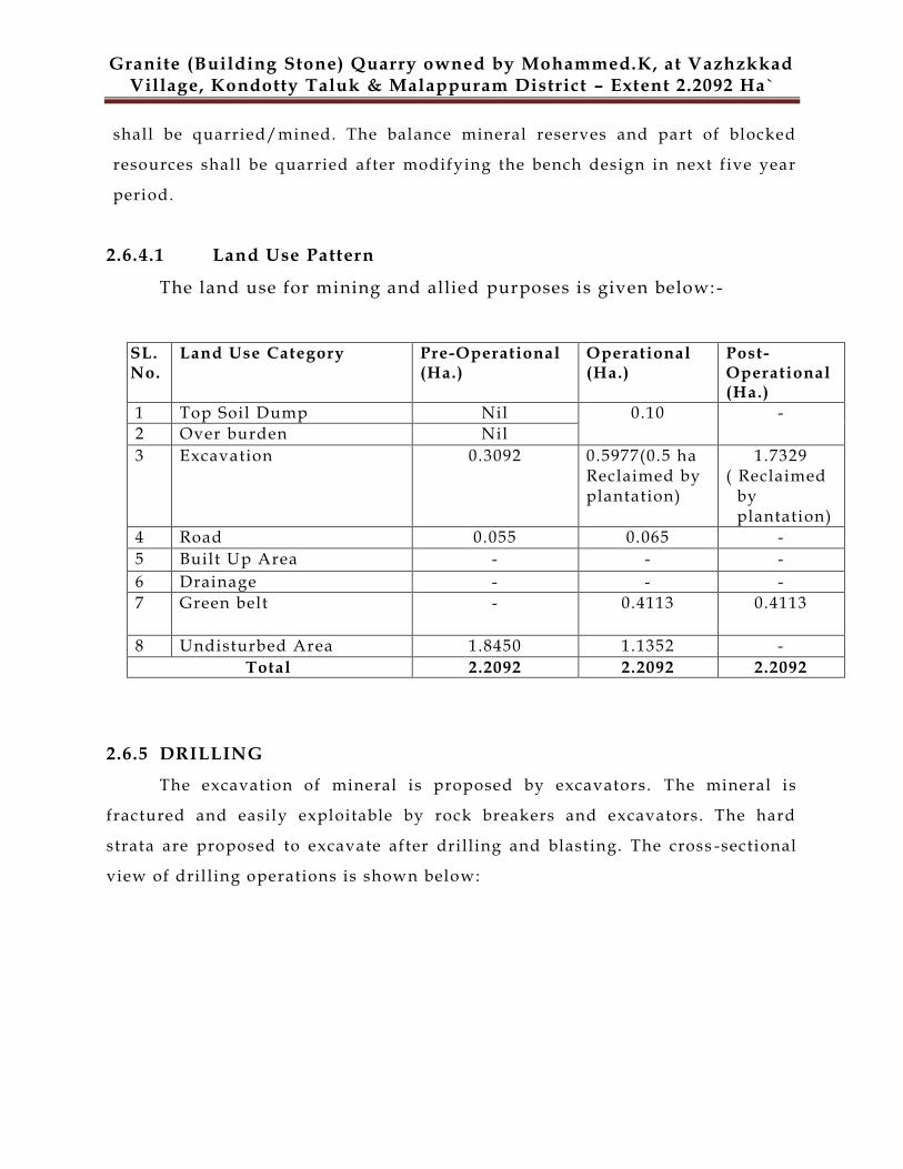
shall be quarried/mined. The balance mineral reserves and part of blocked
resources shall be quarried after modifying the bench design in next five year
period.
2.6.4.1 Land Use Pattern
The land use for mining and allied purposes is given below:-
SL. No.
Land Use Category Pre-Operational (Ha.)
Operational (Ha.)
Post-Operational (Ha.)
1 Top Soil Dump Nil 0.10
- 2 Over burden Nil 3 Excavation 0.3092 0.5977(0.5 ha
Reclaimed by plantation)
1.7329 ( Reclaimed by plantation)
4 Road 0.055 0.065 - 5 Built Up Area - - -
6 Drainage - - - 7 Green belt - 0.4113 0.4113
8 Undisturbed Area 1.8450 1.1352 -
Total 2.2092 2.2092 2.2092
2.6.5 DRILLING
The excavation of mineral is proposed by excavators. The mineral is
fractured and easily exploitable by rock breakers and excavators. The hard
strata are proposed to excavate after dri lling and blasting. The cross -sectional
view of dril ling operations is shown below:
Granite (Building Stone) Quarry owned by Mohammed.K, at Vazhzkkad Village, Kondotty Taluk & Malappuram District – Extent 2.2092 Ha`
2.6.5.1 Salient features of drilling/ blasting
The top soil shall be recovered and used for afforestation / green
belt development / safety barrier development along the periphery
of the lease area.
After exposing the granites, dril ling shall be don e by jack hammer.
The blasting shall be carried out by Cartridge Slurry explosives.
The rock breakers shall be used to break the oversize boulders left
after blasting.
The blasted material and the broken material by rock breakers shall
be loaded to the tippers by excavator and transported to the
crushing and screening plant located outside the lease area. The
crushing and screening shall be carried out by using primary a nd
secondary crushers and the screens of 20mm, 12mm, 10mm & 6mm
opening.
The finished product shall be stacked in the crushing and screening
plant area from where it shall be dispatched to the consumer
directly.
2.6.6 BLASTING
The controlled blasting is proposed by adopting all the safety measures as per “MMR
1961”and with the permission of DGMS. In this area for the fragmentation of rock, the blasting
will be conducted. Multiple blast holes of 1.0-1.5m depth will be drilled with the help of 32mm
Granite (Building Stone) Quarry owned by Mohammed.K, at Vazhzkkad Village, Kondotty Taluk & Malappuram District – Extent 2.2092 Ha`
drill rod, Jack hammer and Air compressor of 100 cfm capacity .It is estimated that about
250gm of explosives per hole is required. About 10-15 holes per blast are proposed. Therefore,
the requirement of explosives will be about 3.75 kg per blast.
The drilling and blasting parameters are as given below.
Depth of each hole : 1.0 to 1.5
Diameter of the hole : 32 mm
App. Spacing between hole : 1m
App. Burden : 0 .6 m to 1m
Hole pattern : Multi row staggered pattern
Explosives to be used : Cartridged Slurry / electric delay detonators
2.6.6.1 Blasting Safeguard
Blasting in the open cast pit will be done only during day time at designated hours as in this project the mining operations are proposed to be carried out in daytime only.
Maintaining safety distance all around the magazine as per statutory requirement.
Only competent blasters will be appoint ed to handle explosives.
Proper, safe and careful handling and use of explosives by competent blasters having Blaster's Certificate of Competency issued by DGMS. Proper security system to prevent theft/ pilferage, unauthorized entry into Magazine
area and checking authorized persons to prevent carrying of matchbox, lights, mobile phones, cigarettes etc .
Controlled blasting technique will be adopted by varying burden, spacing & charge per hole depending upon the field condition.
Holes will be located beyond the weak zone after proper inspection of the site.
The explosives of class2 will be used in their original cartridge packing and such cartridge shall not be cut to remove explosives for making cartridge of different size.
Carrying out blasting during designated time only that too day time only and displaying a board in the mine entrance specifying the blasting time. Posting guards at boundaries of the lease area and giving warning signal by way of whistle or siren blowing before blasting, to prevent unauthorized entry and to prevent mishaps.
Granite (Building Stone) Quarry owned by Mohammed.K, at Vazhzkkad Village, Kondotty Taluk & Malappuram District – Extent 2.2092 Ha`
Detonators will be conveyed in special containers .These will not be carried with other explosives.
2.6.6.2 Types of Explosives Used
Only class 2 and class 6 explosive is proposed for use as given below: -
SL.NO NAME AND
DESCRIPTION
CLASS &DIVISION SUB-DIVISION(IF
ANY)
1 Nitrate Mixture 2,0 0
2 Safety Fuse 6,1 0
3 Ordinary Detonators 6,3 0
4 Electric and/or
Ordinary Detonators
6,3 0
2.6.6.3 Storage of Explosive
Considering low consumption, a 75 kg magazine exists for storing the
explosive. The magazine is nearby 100m of the mine boundary. The controlled
blasting is proposed by adopting all the safety measures as per “MMR 1961”
and with the permission of DGMS.
Blasting will be performed as per requirement on the face. The explosive s are
supplied by authorized dealers and the blasting will be carried out under
personal supervision of DGMS approved blaster
2.7 MINERAL TRANSPORTATION
Loading of mineral will be done by excavator and will be sent to the crusher
located outside the lease area fo r sizing. Trucks / Tippers of 10T will be used
for transportation of mineral from mi ne site. It is expected that 25-27 trips will
be required to transport on daily basis. For this, move ment of truck per hour
will be 3-4 only. Thus, the impact due to movement of trucks from the mine
will be marginal and well within the capacity of the roads.
Granite (Building Stone) Quarry owned by Mohammed.K, at Vazhzkkad Village, Kondotty Taluk & Malappuram District – Extent 2.2092 Ha`
2.8 EMPLOYMENT POTENTIAL
There is no infrastructure available in the mine area.
The total number of employees including skilled and un -skilled workers is
12 which include workers for mine and ancillary unit. The details of the
employees/workers employed in the quarry are given below:-
TOTAL TEAM OF QUARRY OPERATION Sr. No. NAME OF THE POST NOS.
1 HIGHLY SKILLED 2
2 SKILLED 3
3 SEMI-SKILLED 5
4 UN-SKILLED 2
TOTAL 12
2.9 WATER REQUIREMENT & SOURCE
The total water requirement for the proposed activity is 2.5 KLD. The detailed breakup of
the same is given below:-
The water required will be sourced from the open well. Top soil excavated from the
quarry will be dumped separately and the overburden can be reutilized as soil base for
plantation.
2.10 POWER
No electricity is needed for quarry operations as only diesel operated
mining machineries are used.
***************
S. No. Particulars Quantity (KLD)
1. Domestic purpose 0.5
2. Dust Suppression / Water sprinkling 1
3. Green belt / Plantation 1
Total 2.5
Granite (Building Stone) Quarry owned by Mohammed.K, at Vazhzkkad Village, Kondotty Taluk & Malappuram District – Extent 2.2092 Ha`
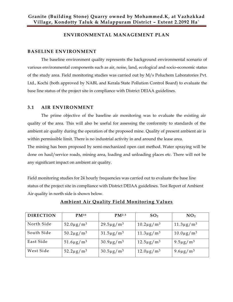
ENVIRONMENTAL MANAGEMENT PLAN
BASELINE ENVIRONMENT
The baseline environment quality represents the background environmental scenario of
various environmental components such as air, noise, land, ecological and socio-economic status
of the study area. Field monitoring studies was carried out by M/s Poluchem Laboratories Pvt.
Ltd., Kochi (both approved by NABL and Kerala State Pollution Control Board) to evaluate the
base line status of the project site in compliance with District DEIAA guidelines.
3.1 AIR ENVIRONMENT
The prime objective of the baseline air monitoring was to evaluate the existing air
quality of the area. This will also be useful for assessing the conformity to standards of the
ambient air quality during the operation of the proposed mine. Quality of present ambient air is
within permissible limit. There is no industrial activity in and around the lease area.
The mining has been proposed by semi-mechanized open cast method. Water spraying will be
done on haul/service roads, mining area, loading and unloading places etc. There will not be
any significant impact on ambient air quality.
Field monitoring studies for 24 hourly frequencies was carried out to evaluate the base line
status of the project site in compliance with District DEIAA guidelines. Test Report of Ambient
Air quality in north side is shown below.
Ambient Air Quality Field Monitoring Values
DIRECTION PM1 0 PM2 . 5 SO2 NO2
North Side 52.0µg/m3 29.5µg/m3 10.2µg/m3 11.3µg/m3
South Side 50.2µg/m3 31.5µg/m3 11.3µg/m3 10.0µg/m3
East Side 51.6µg/m3 30.9µg/m3 12.5µg/m3 9.5µg/m3
West Side 52.2µg/m3 30.5µg/m3 12.0µg/m3 9.6µg/m3
Granite (Building Stone) Quarry owned by Mohammed.K, at Vazhzkkad Village, Kondotty Taluk & Malappuram District – Extent 2.2092 Ha`
Results & Conclusions: It is seen that the ambient air monitoring results
obtained are well within the prescribed standards (NAAQS) with resp ect to
PM10, PM2.5, NO2 and SO2.
3.2 WATER ENVIRONMENT
The purpose of this study is to: -
Assess the water quality characteristics for critical parameters;
Evaluate the impacts on agricultural productivity, habitat conditions,
recreational resources and aesthetics in the vicinity; and
Predict the likely impacts on water quality due to the project and related
activities.
To analyze the suitability of water for mining purpose, water sample from open
well close to the quarry (within their own property) were collected.
The sample was collected by grab sampling technique. The sample was analyzed
as per the procedures specified in „Standard Methods for the Examination of
Water & Wastewater‟ published by American Public Health Association
(APHA).
Results & Conclusions: -
There is no water regime of any importance in the quarry area. Drinking
water is made available through bore wells. This water is being used for
drinking purpose from many years.
Detailed Report of Water Quality of the proposed site is enclosed in the Mining
Plan
3.2.1 HYDROGEOLOGY
Ground water occurs under phreatic, semi -confined and confined
conditions in the above formations. The weathered Charnockites, Granite
gneiss, schists and laterites form the major phreatic aquifers, whereas the deep
fractures in the Charnockites, Granite G neiss & schists and the granular zones
Granite (Building Stone) Quarry owned by Mohammed.K, at Vazhzkkad Village, Kondotty Taluk & Malappuram District – Extent 2.2092 Ha`
in the Tertiary sedimentary formations form the potential confined to semi
confined aquifers.
The Archaean rocks: - The shallow aquifers of the Archaean rocks are made
up of the highly decomposed weathered zone or partly weathered and fractured
rock. Thick weathered zone is seen along the midland area either beneath the
Laterites or exposed. In the hill ranges, thin wea thered zone is seen along
topographic lows, area with lesser elevation and gentle slope. In areas along the
hill ranges generally rock exposures are seen. The depth to water level in this
aquifer varies from 2 to 16 mbgl and the yield of the well ranges be tween 2 to 10
cu.m. per day.
Laterites: - The depth to water level in the formation ranges from less than a
meter to 25 mbgl. Laterite forms potential aquifers along valleys and can sustain
medium duty irrigation wells with the yields in the range of 0.5 - 6 cu.m. per
day. The occurrence and movement of ground water in the Laterites are mainly
controlled by the topography. Laterite is a highly porous rock formation, which
can form potential aquifers along topographic lows. However, due to this same
porous nature, groundwater is drained from elevated places and slopes at
shortest duration after monsoon due to which scarcity is experienced in the
elevated places and slopes.
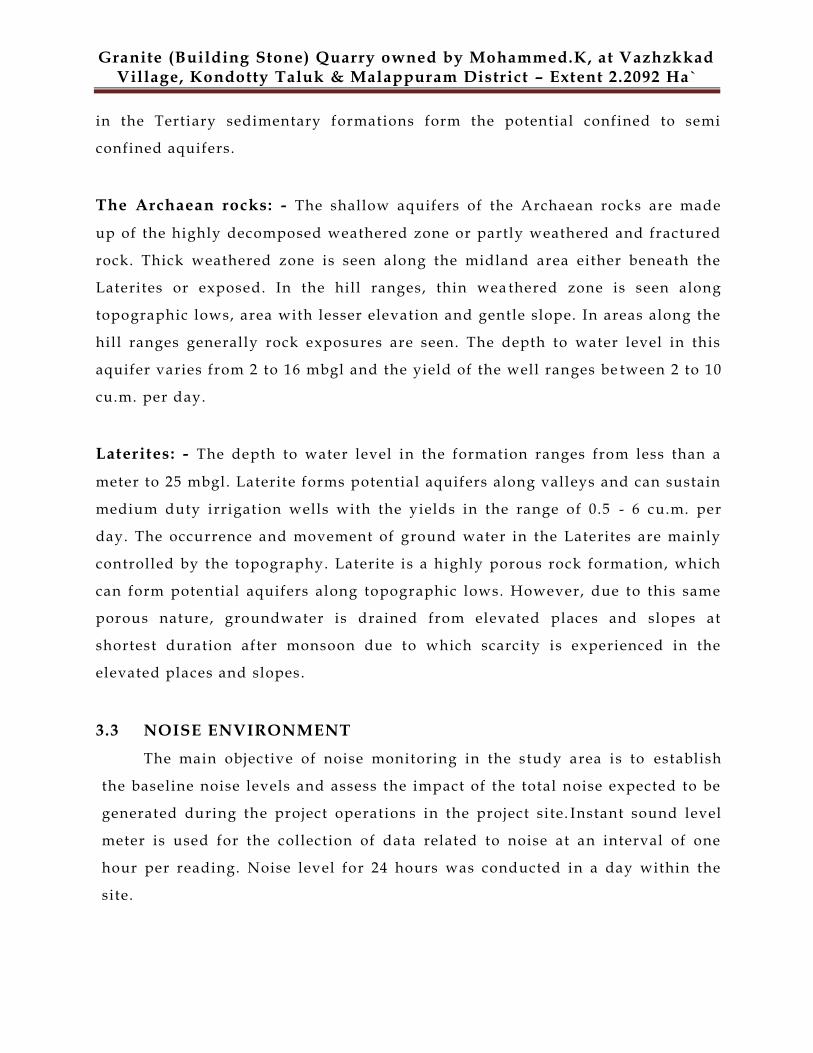
3.3 NOISE ENVIRONMENT
The main objective of noise monitoring in the study area is to establish
the baseline noise levels and assess the impact of the total noise expected to be
generated during the project operations in the project si te. Instant sound level
meter is used for the collection of data related to noise at an interval of one
hour per reading. Noise level for 24 hours was conducted in a day within the
site.
Granite (Building Stone) Quarry owned by Mohammed.K, at Vazhzkkad Village, Kondotty Taluk & Malappuram District – Extent 2.2092 Ha`
Ambient Noise Monitoring Results
MONITORING
LOCATION
AMBIENT SOUND
LEVEL IN DAY TIME
AMBIENT SOUND LEVEL
IN NIGHT TIME
North Side Boundary 50.1 dB(A) 34.2 dB(A)
South Side Boundary 48.5 dB(A) 34.0 dB(A)
East Side Boundary 49.8 dB(A) 35.2 dB(A)
West Side Boundary 49.2 dB(A) 33.0 dB(A)
Vibration levels (due to blasting) The drilling is proposed by jack hammer with 33mm dia. The blasting shall be
done individually. Due to very small diameter hole blasting the vibration in
this area shall be very minor.
Results and conclusion: -
It is seen from the obtained results that t he Noise levels are well within the
prescribed national standards is enclosed in the Mining Plan .
3.4 BIOLOGICAL ENVIRONMENT
Study of biological environment is one of the important aspects in
Environmental Impact Assessment in view of the need for conserv ation of
Environmental quality. A detailed study has been carried for enumeration of
species. Occurrences of flora at various locations were observed and typical
plant species were collected. The visual observations of plants were recorded
with a view to obtain some idea about the relative density of certain species and
their predominance.
Primary survey for flora and fauna studies has been conducted in the core zone.
Granite (Building Stone) Quarry owned by Mohammed.K, at Vazhzkkad Village, Kondotty Taluk & Malappuram District – Extent 2.2092 Ha`
3.4.1 FLORA
Existing Flora in the Project Area
TREES
Conclusion: - There is no flora species existing at site which are in the red
Granite (Building Stone) Quarry owned by Mohammed.K, at Vazhzkkad Village, Kondotty Taluk & Malappuram District – Extent 2.2092 Ha`
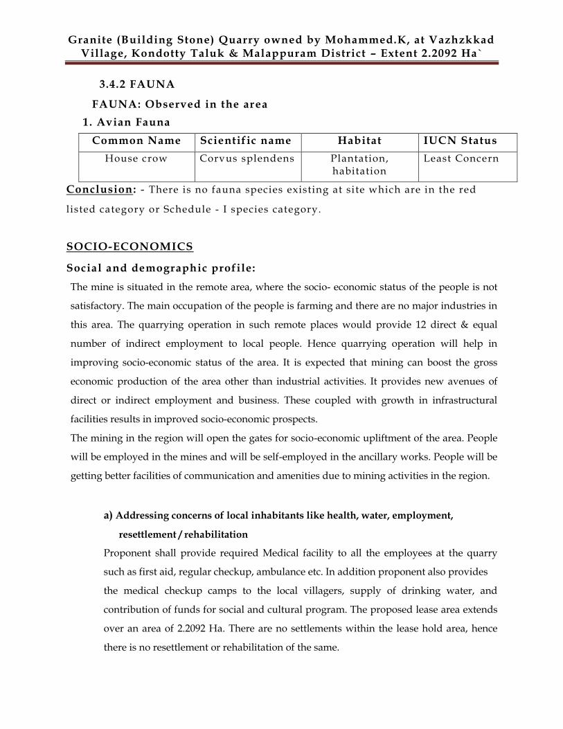
3.4.2 FAUNA
FAUNA: Observed in the area
1. Avian Fauna
Common Name Scientific name Habitat IUCN Status
House crow Corvus splendens Plantation, habitation
Least Concern
Conclusion: - There is no fauna species existing at si te which are in the red
listed category or Schedule - I species category.
SOCIO-ECONOMICS Social and demographic profile:
The mine is situated in the remote area, where the socio- economic status of the people is not
satisfactory. The main occupation of the people is farming and there are no major industries in
this area. The quarrying operation in such remote places would provide 12 direct & equal
number of indirect employment to local people. Hence quarrying operation will help in
improving socio-economic status of the area. It is expected that mining can boost the gross
economic production of the area other than industrial activities. It provides new avenues of
direct or indirect employment and business. These coupled with growth in infrastructural
facilities results in improved socio-economic prospects.
The mining in the region will open the gates for socio-economic upliftment of the area. People
will be employed in the mines and will be self-employed in the ancillary works. People will be
getting better facilities of communication and amenities due to mining activities in the region.
a) Addressing concerns of local inhabitants like health, water, employment,
resettlement / rehabilitation
Proponent shall provide required Medical facility to all the employees at the quarry
such as first aid, regular checkup, ambulance etc. In addition proponent also provides
the medical checkup camps to the local villagers, supply of drinking water, and
contribution of funds for social and cultural program. The proposed lease area extends
over an area of 2.2092 Ha. There are no settlements within the lease hold area, hence
there is no resettlement or rehabilitation of the same.
Granite (Building Stone) Quarry owned by Mohammed.K, at Vazhzkkad Village, Kondotty Taluk & Malappuram District – Extent 2.2092 Ha`
b) Compensation for loss of land, crops and other adverse impacts on account of Mining
Entire lease area belongs to lessee hence there is no compensation for loss of land. Due
to the quarry activities, if any crop/s are damaged to the adjacent land, the lessee will
pay the compensation for the said crop which will be decided by the agriculture /
concerned department.
Occupational health and safety hazards : The main areas of concern for ensuring adequate occupational health and
safety are:
All working places will have safe means of access: safe working platform and
exist.
Persons working in hazardous dust prone area will be provided with dusk mask.
Personal protective equipments like respirators, ear plug noise muff, helmet etc
will be provided to workers.
Adequate arrangement of drinking water will be done.
Education & training will be provided to the workforce about facilities,
protective equipment, risk associated, potential health effects, etc.
Display board will be provided showing the hazards associated and
recommended precautionary measures.
Historical monuments etc. There are no historical monuments in the core or buffer zone.
Topsoil & Overburden Management: A total quantity of 10,011 cu.m of topsoil is proposed to be removed during the mining
operations. The topsoil excavated from the quarry will be dumped separately at pre-
determined place and subsequently will be utilized in spreading over reclaimed areas for
plantation. Precautions will be taken to limit the height of the topsoil dump to 5 to 6 meters
in order to preserve its fertility. It will be suitably protected from soil erosion and infertility
by planting fodder grass and leguminous plants during temporary storage.
About 13,348 cu.m of overburden will be generated throughout the mine life.
This waste will be utilized within the pit for lying of haul roads. At the end use, overburden
can be re utilized as soil base for plantation.
Granite (Building Stone) Quarry owned by Mohammed.K, at Vazhzkkad Village, Kondotty Taluk & Malappuram District – Extent 2.2092 Ha`
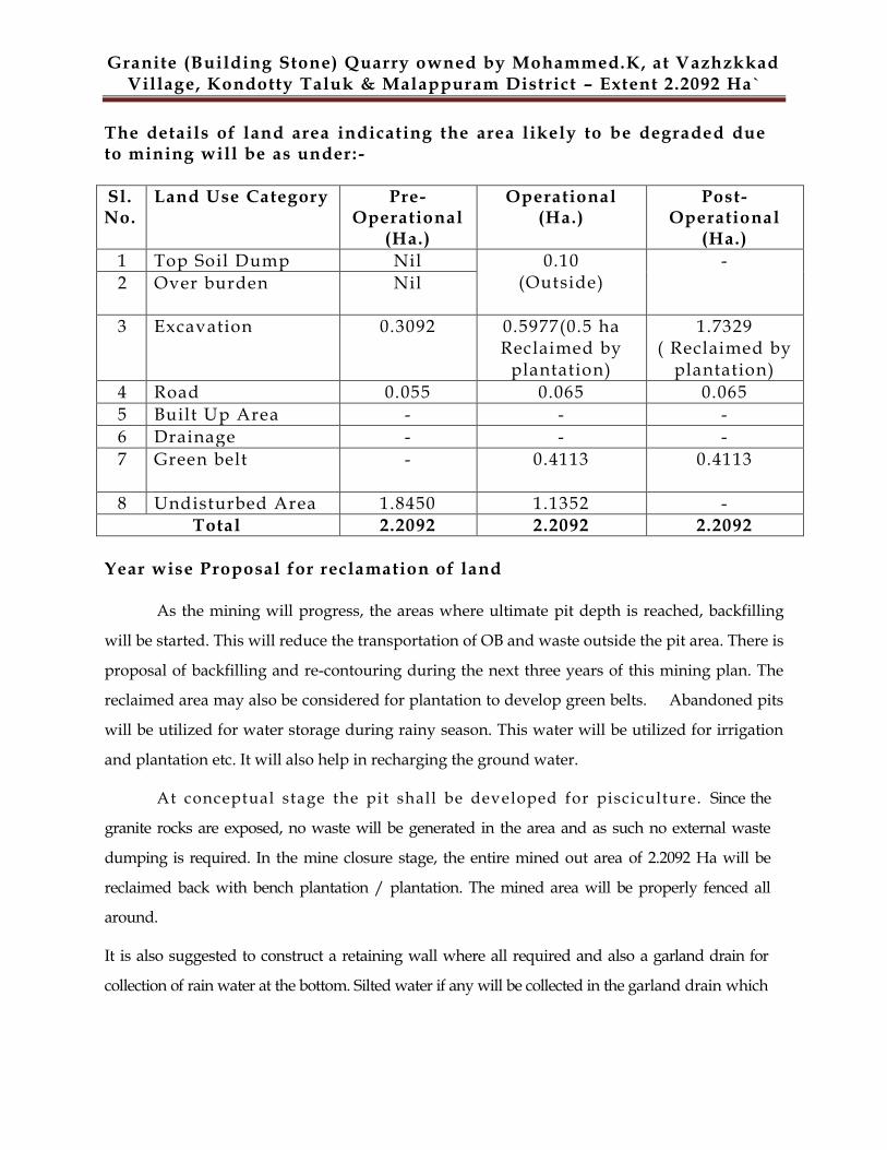
The details of land area indicating the area likely to be degraded due to mining will be as under: -
Sl. No.
Land Use Category Pre-Operational
(Ha.)
Operational (Ha.)
Post-Operational
(Ha.)
1 Top Soil Dump Nil 0.10 (Outside)
-
2 Over burden Nil
3 Excavation 0.3092 0.5977(0.5 ha Reclaimed by
plantation)
1.7329 ( Reclaimed by
plantation)
4 Road 0.055 0.065 0.065
5 Built Up Area - - -
6 Drainage - - -
7 Green belt - 0.4113 0.4113
8 Undisturbed Area 1.8450 1.1352 - Total 2.2092 2.2092 2.2092
Year wise Proposal for reclamation of land
As the mining will progress, the areas where ultimate pit depth is reached, backfilling
will be started. This will reduce the transportation of OB and waste outside the pit area. There is
proposal of backfilling and re-contouring during the next three years of this mining plan. The
reclaimed area may also be considered for plantation to develop green belts. Abandoned pits
will be utilized for water storage during rainy season. This water will be utilized for irrigation
and plantation etc. It will also help in recharging the ground water.
At conceptual stage the pit shall be developed for pisciculture. Since the
granite rocks are exposed, no waste will be generated in the area and as such no external waste
dumping is required. In the mine closure stage, the entire mined out area of 2.2092 Ha will be
reclaimed back with bench plantation / plantation. The mined area will be properly fenced all
around.
It is also suggested to construct a retaining wall where all required and also a garland drain for
collection of rain water at the bottom. Silted water if any will be collected in the garland drain which
Granite (Building Stone) Quarry owned by Mohammed.K, at Vazhzkkad Village, Kondotty Taluk & Malappuram District – Extent 2.2092 Ha`
in turn will flow into settling pond. Supernatant clear water will be let out of the area after passing
through silt traps.
Afforestation Programme
The year wise programme of eco-restoration for the life of mine, about
1000 trees will be planted in an area of 0.4113 ha.
Biological reclamation / ecological restoration for the mined area by
plantation of the species as per the time schedule suggested b elow: -
First Six months -- Herbs & grass
Next Six months -- Shrubs
Next Six months onwards -- Trees
Selection of species is based on High Dust Capturing, Soil Holding Capacity,
ground water recharge capacity etc. More focus is given for medicinal plants.
Plantation along the boundary of the lease area i .e . within 7.5 m barrier of the
lease area boundary has been proposed which will help to improve the
environment and ecology. Plantation will be done around offices, road side
and fencing boundary etc.
Treatment and disposal of water from mine:
Except during monsoon months, no water shall be discharged from mine. A
garland drain shall be made all around the quarry to divert the water away
from the pit through silt settling tank. The rain water shall be diverted to its
natural course.
Measures for minimizing adverse effects on water regime:
The water that would be encountered in the project is rainwater. A
garland drain shall be made all around the periphery of quarry to divert the
water away from the pit. The water shall be collected at silt settling tank
before diverting that to its natural course. However granite (building stone) is
not a toxic and hence there shall not be any chemical hazardous effect.
Granite (Building Stone) Quarry owned by Mohammed.K, at Vazhzkkad Village, Kondotty Taluk & Malappuram District – Extent 2.2092 Ha`
Protective measures for ground vibrations/air blast caused by blasting:
The drilling is proposed by jack hammer with 33mm dia. Due to small diameter
hole blasting the vibration in this zone shall not be even noticeable. The nearest
village Vazhakkad is situated at about 6kms away from the mine. However the
measures like monitoring every blast and use of minimum explosives shall be
taken.
Measures for protecting historical monuments and for rehabilitation of Habitat, settlements, disturbed due to mining activity: There are no historical monuments in the core or buffer zone.
Socio-economic benefits arising out of mining: It is expected that mining can boost the gross economic production of the area
other than the industrial activities. It provides new avenues of direct/indirect
employment and business. These coupled with growth in infrastructural
facilities results in improving socio-economic prospects.
The mining in the region will open the gates for Socio -economic upliftment of
the area. People will be getting better facilities of communicati on and amenities
due to mining activit ies in the region .
Monitoring schedules for different environmental components after the commencement of mining operations and related activities For this quarrying project a quarterly monitoring mechanism f or various
environmental parameters shall be evolved .
Waste Management About 13,348 cum of overburden will be generated throughout the mine life.
This waste will be utilized within the pit for lying of haul roads.
Top Soil Management
A total quantity of 10,011 cu.m. of topsoil is proposed to be removed during the
mining operations. The topsoil excavated from the quarry will be dumped
separately at pre-determined place and subsequently will be utilized in spreading
Granite (Building Stone) Quarry owned by Mohammed.K, at Vazhzkkad Village, Kondotty Taluk & Malappuram District – Extent 2.2092 Ha`
over reclaimed areas for plantation. Precautions will be taken to limit the height
of the topsoil dump to 5 to 6 meters in order to preserve its fertility and shelf life.
It will be suitably protected from soil erosion and infertility by planting fodder
grass and leguminous plants during temporary storage.
Safety & Security:
For safety the lease hold areas shall be fenced with proper gates which shall
be guarded by security personals.
Disaster Management & Risk Assessment: Risk assessment is a process whereby risks are analyzed, assessed and
risk management priorities are evaluated. It is defined as the
characterization of the potential adverse effect to human health &
environment due to environmental hazards.
Objectives of risk assessment are: -
Identifying hazardous activities
Assessment of risk level and severity in different operations
Identification of control measures
Setting monitoring process
Reduce the impact of mishaps of all kinds
Factors of risks involved due to human induced activities in connection
with this quarry operations are 1) removal of O.B, waste material and side
burden 2) drilling 3) blasting 4) excavation and 5) transportation
Other risk factors due to natural activities are 1) fire 2) water inundation
3) electricity and 4) natural calamities.
No disaster is expected in this small scale of quarrying; however as an
emergency the location of the hospital, police station and fire bri gade is given
Granite (Building Stone) Quarry owned by Mohammed.K, at Vazhzkkad Village, Kondotty Taluk & Malappuram District – Extent 2.2092 Ha`
in the Table shown below.
Table No. 12.3: Location of Stations during Emergency from Quarry In case of any eventuality the following person will be available for contact .
Mohammed. K
Koorikkattil House,
Kannamvettikkavu P.O,
Pulikkal (via),
Malappuram District – 673 637, Kerala.
Mobile no: 9847157538
Care and maintenance during temporary discontinuance: The following specif ic measures shall be taken during temporary discontinuance,
a. The pit shall be fenced.
b. Proper and adequate security at the entrance to the mine to prevent entry of
unauthorized person with proper gates under lock.
c. All the above will be examined by manager once in a week to ensure that they are in
order.
Stations Location of Station Distance
Hospital
General Hospital, Vazhakkad
6 km
Police Station Vazhakkad Police Station 7 km
Fire Brigade Meenchantha-Calicut Fire Station
20 km
Granite (Building Stone) Quarry owned by Mohammed.K, at Vazhzkkad Village, Kondotty Taluk & Malappuram District – Extent 2.2092 Ha`
4.0 ENVIRONMENT MONITORING PROGRAM
Environmental monitoring program is a vital process of any management plan
of the development project. This helps in signaling the potential problems
resulting from the proposed project and will allow for prompt implementation
of effective corrective measures. Environmental monitoring will be required for
the operation and closure of mining operations.
The main objectives of environmental monitoring are
To assess the changes in environmental conditions,
To monitor the effective implementation of mitigation measures,
Warn significant deteriorations in environmental quality for further Prevention action.
a) AIR ENVIRONMENT
Apart from the mining operations of drilling & blasting, movement of vehicles like
dumpers, trucks, tankers etc. will generate dust.
Mitigation Measures:
Mining activities will generate certain quantities of dust during drilling, blasting,
loading and transportation operations. The following measures will be taken to
mitigate the fugitive dust from these operations.
Lying of haul road as per the standards, black topping of permanent haul road
and service road to avoid or eliminate air – borne dust.
To avoid the dust generation from the drilling operations, wet drilling method
will be adopted.
Drill machines will be equipped with dust collectors.
Use of appropriate explosives for blasting and avoiding overcharging of blast
holes.
Controlled blasting techniques will be adopted.
Watering of haul road and other road at regular intervals.
Provision of dust filters/ mask to workers for highly dust prone and affected
areas.
Provision of green belt all along the periphery of the lease area.
• Periodical monitoring of ambient air quality in and around the lease area
Granite (Building Stone) Quarry owned by Mohammed.K, at Vazhzkkad Village, Kondotty Taluk & Malappuram District – Extent 2.2092 Ha`
b) NOISE ENVIRONMENT
The Noise is the environment attribute associated with the quarrying activity and operation of
heavy machinery operation which causes vibration and noise. The quarrying operation will be
restricted to only day time. To attenuate noise, various measures shall be taken up from the
source point. The activity such as drilling shall be updated to latest technology which involves
wet drilling technology and blasting will be carried out with controlled mechanism. Persons
who are exposed to critical operation like drilling and operation of excavators are being
provided with personal protective equipment‟s (PPEs) as Occupational Safety Measures.
Greenbelt will be developed, which will act as an acoustic barrier for noise transmission.
Mitigation Measures:
The following noise control measures are undertaken to bring down the noise levels:-
Proper maintenance of machinery, equipment‟s and improvement on design of
machines.
Use of personal protective devices i.e., earmuffs and earplugs by workers, who
are working in high noise generating areas.
Regular medical check-up related health problems.
Proper training to personnel to create awareness about adverse noise level
effects.
Planned noise monitoring at suitable locations in the plant and outside location
for proper effective remedial actions.
c) LAND ENVIRONMENT
Mitigation Measures
In order to minimize the adverse effects, the following suggestions have been made.
Concurrent eco restoration will be carried out.
Green belt development along the boundary of the lease area.
Most part of the proposed land is already under mining and thus is no topsoil to
be removed in this area.
Granite (Building Stone) Quarry owned by Mohammed.K, at Vazhzkkad Village, Kondotty Taluk & Malappuram District – Extent 2.2092 Ha`
Since the proposed land is already under mining, there is no overburden in this
area.
4.1 REPORTING & DOCUMENTATION
All the necessary reports and documents shall be prepared to comply with the statutory rules &
regulations. Proper and due care shall be taken to adhere to the laid down rules and regulations by
the government.
Regular and periodic record shall be kept in order to ensure easier, comparable and brisk review
and projection of past, present and future performances. Also, the management shall ensure to
prepare separate records for water, wastewater, solid waste, air, emission, soil & manure
regularly and periodically in order to provide better and smooth vigilance.
The management shall look into the fact that as soon as the report is prepared, it shall be
forwarded to the concerned authority with due care for the purpose of reviewing.
Adhering to the rules and regulations the management shall ensure that the outcome of the reports
and the conclusions drawn shall be prepared as per the laid down regulations and procedures. No
breach of any convention shall be availed.
These reports/documents shall be regularly and periodically reviewed and any
changes/discrepancies found in mitigation measures/ operation/ management/ shall be brought
into notice instantaneously and all possible corrective actions shall be taken.
1.0 CONCLUSION
It is anticipated that socio-economic impact due to this project will positively
enhance the raw materials for the developmental conce rns and also may provide
ample chances of more employment opportunities for local inhabitants. There
are no Resettlement and Rehabilitation issues and li tigations in any courts of
law pending involved in this project. The project infrastructures can be uti lized
for the benefit of the local people of the area. The revenue of the State Govt.
will be definitely increasing due to the proposed activity by means of CRP as
well as the processing fee for appropriate statutory clearances involved in the
procedures. The entire project area is devoid of any endangered flora and fauna
Granite (Building Stone) Quarry owned by Mohammed.K, at Vazhzkkad Village, Kondotty Taluk & Malappuram District – Extent 2.2092 Ha`
as specified in the IUCN records and the area is totally far from any other
protected areas under the Wildlife Protection Act as well as the Forest Act. It is
proposed to reclaim the land and develop green cover for eco-restoration with
native species to a maximum extent as far as possible. Thus the proposed project
is not having any possibility in generating untoward changes which is capable
for altering the equilibrium status of the environment or adjacent ecosystem


![Welcome [unisonfgpartners.com.au]unisonfgpartners.com.au/pdf/FINDEX-FMGMT.pdf4.0 1.0 1.0 1.0 1.0 1.0 1.0 50.0 43.5 34.5 25.5 12.5 5.5 9.0 9.0 8.0 7.0 5.0 2.0 5.0 5.0 5.0 5.0 5.0 14.0](https://static.documents.pub/doc/80x56/5f9881d4934d305cce543099/welcome-40-10-10-10-10-10-10-500-435-345-255-125-55-90-90-80.jpg)


