43 10.0 EXTENSION TO THE CONSERVATION AREA BOUNDARY 10.1 The original Conservation Area boundary was drawn tightly around the edges of the buildings within the settlement. One of the most distinctive features of Monyash, however, is the uniquely well-preserved pattern of medieval strip fields, defined by later drystone boundary walls, which surround the settlement, extending out from the crofts within the centre of the village. 10.2 The piecemeal enclosure of these irregular, narrow strip fields pre-dated the Parliamentary enclosures of the 1770s and the Authority’s Historic Landscape Characterisation (1996) classifies the whole field system surrounding Monyash as ‘Ancient Enclosures’. 10.3 There is no clear visual or physical separation between the historic settlement and its fossilised medieval field system. This close integration between built environment and landscape is one of the most distinctive features of Monyash and is of key significance to the historic character and appearance of the Conservation Area. 10.4 As part of this Appraisal, the Conservation Area boundary was extended to include part of the surviving medieval strip fields that surround the settlement and provide its context, as shown in Figure 14. P10.1 Monyash village surrounded by its fossilised medieval field system
Transcript
43
100 EXTENSION TO THE CONSERVATION AREA BOUNDARY
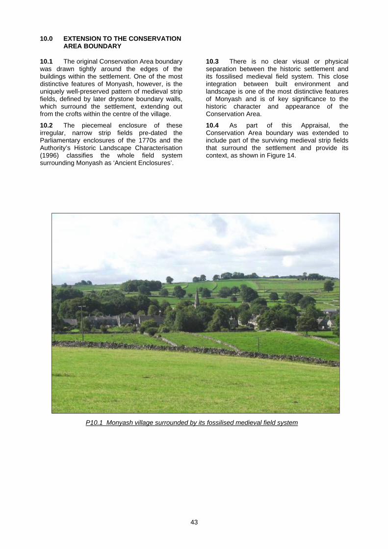
101 The original Conservation Area boundary was drawn tightly around the edges of the buildings within the settlement One of the most distinctive features of Monyash however is the uniquely well-preserved pattern of medieval strip fields defined by later drystone boundary walls which surround the settlement extending out from the crofts within the centre of the village
102 The piecemeal enclosure of these irregular narrow strip fields pre-dated the Parliamentary enclosures of the 1770s and the Authorityrsquos Historic Landscape Characterisation (1996) classifies the whole field system surrounding Monyash as lsquoAncient Enclosuresrsquo
103 There is no clear visual or physical separation between the historic settlement and its fossilised medieval field system This close integration between built environment and landscape is one of the most distinctive features of Monyash and is of key significance to the historic character and appearance of the Conservation Area
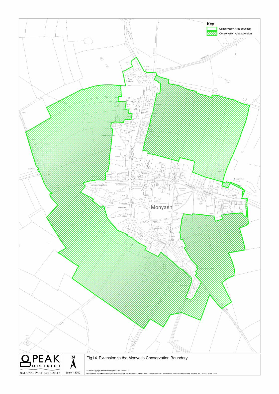
104 As part of this Appraisal the Conservation Area boundary was extended to include part of the surviving medieval strip fields that surround the settlement and provide its context as shown in Figure 14
P101 Monyash village surrounded by its fossilised medieval field system
110 POTENTIAL FOR IMPROVEMENT
111 The purpose of this Section is to examine the special character and appearance of the Conservation Area and identify opportunities for improvements
112 Monyash village was revitalised in 1981 when the Integrated Rural Development scheme injected new investment and created new opportunities in the village As a result the village hall was built a childrenrsquos play area constructed the school extended buildings restored and businesses helped Grants were provided to maintain the many miles of drystone walls provide water supplies to fields develop flower-rich fields and plant new woodland areas
113 The Conservation Area is in comparatively good condition with few neutral or negative areas or elements requiring enhancement However there are some improvements which could be made if the opportunity were to arise Some of the issues mentioned below could be addressed by the Peak District National Park Authority andor Derbyshire County Council Other items would need to be addressed by private individuals and in some cases enhancement may not be achievable It should be noted that the character of Monyash Conservation Area could easily be spoiled if it were to become over-manicured
Improving modern development
114 In general the small areas of twentieth century housing within Monyash Conservation Area have been constructed relatively sympathetically having a mostly neutral impact on the character of the Conservation Area Any new development needs to be designed with care to ensure that it does not detract from the character of the Conservation Area
Repairing historic buildings and structures
115 Buildings within Monyash Conservation Area are in relatively good condition However buildings need continual maintenance and repairs Listed and other historic properties in the Conservation Area may be entitled to grant-aid from the Authority subject to the eligibility of the proposed work and the availability of resources For further information on grants contact the Authorityrsquos Cultural Heritage team (on 01629 816200) or refer to the Peak District National Park Authorityrsquos website (wwwpeakdistrictgovuk)
116 Traditional stone boundary walls both within the village itself and defining the medieval strip fields surrounding it are of particular importance in the Monyash Conservation Area These should be retained and where necessary repaired 67 of the area covered by the proposed Conservation Area boundary extension
currently falls within agri-environment schemes which afford the walls a degree of protection Some of the field boundary walls may require attention and agri-environment scheme agreements could be one way of improving their condition A general condition survey of these walls could be beneficial in identifying where work is needed
Avoiding unsympathetic repairs and replacement of traditional features
117 Unsympathetic alterations and repairs can have a detrimental impact on a propertyrsquos aesthetic and structural qualities Minor works such as the installation of windows and doors that are inappropriate in design andor materials (eg upvc) or the use of cement-based mortars and strap pointing soon accumulate and erode the special character of a place Within the Monyash Conservation Area many traditional windows and doors have been replaced with upvc and this significantly detracts from the character and integrity of the settlementrsquos historic properties Any owner wishing to replace any type of window should contact the Authorityrsquos Cultural Heritage Team for further advice
118 The use of non-traditional materials such as concrete render and imported andor artificial materials such as concrete roofing tiles and upvc should be avoided as this detracts from the historic character and architectural quality of the buildings The use of modern materials in new developments within the Conservation Area will only be considered in exceptional circumstances In these instances the materials and detailing should be of a high quality
119 Modern boundary types such as timber post and rail or concrete post and timber boarded fences would have a detrimental impact on the character of the Conservation Area and should be avoided
1110 Unsympathetic extensions and additions to a traditional building may not only have a negative impact on the historic quality of the building but can also detract from the character of the Conservation Area at that point
1111 The Authorityrsquos Design Guide has further information on materials alterations extensions and enhancement to unsympathetic developments See the Authorityrsquos website (wwwpeakdistrictgovuk) for further details
1112 Unsympathetically located modern fixtures on prominent elevations and roofs such as satellite dishes roof-lights solar panels and wind turbines can quickly accumulate and have a detrimental impact on the character of the Conservation Area Please check with the Authorityrsquos Planning Service (on 01629 816200) before installing any such item
45
Sustainability
1113 Conservation Areas are inherently supportive of sustainability as they promote the re-use of traditional buildings encourage the use of local materials and repair over replacement and ensure the protection of trees There is always potential to improve sustainability within a Conservation Area This can be achieved by improving the energy efficiency of buildings and reducing their energy consumption and carbon footprint These issues shall be considered in more detail in any future Conservation Area Management Plan
Protecting trees and shrubs
1114 Trees and shrubs make an essential contribution to the character of Monyash and their removal would have a negative impact on the Conservation Area Some hedgerows are protected from destruction or damage under the Hedgerows Regulation 1997 The Town and Country Planning Act 1990 makes special provision for trees in Conservation Areas which are not the subject of Tree Preservation Orders anyone proposing to cut down or carry out work to a tree is required by legislation to give the Planning Authority six weeks notice of their intention to do so The Authorityrsquos Tree Conservation Officer should be contacted (on 01629 816200) before any lopping or felling of trees shrubs or hedges takes place and before carrying out any other work to hedges
Maintaining spaces and streetscape
1115 To the western edge of the car park on Chapel Street is a small dilapidated building the repair of which would enhance this busy public area
1116 Overhead telephone wires have a detrimental impact at various points and the Conservation Area would benefit if these were laid underground
Conserving traditional paving
1117 There is a variety of floor surfaces old and new in the Conservation Area Traditional treatments such as stone kerbs flags steps and stone squeezer stiles survive in some areas but the floor treatment to a majority of the public realm comprises tarmac Wherever possible traditional stone surfaces should be retained and the reinstatement of stone kerbs should be encouraged
Improving lighting
1118 The standard of street lighting in Monyash could be improved Some of the existing lights are in prominent positions in the street
scene and their utilitarian design therefore has a detrimental impact on significant views in a number of places (see P74 P76 and P711) In addition all lighting including street lighting and exterior lighting on residential and business properties should minimise where possible the impact of light pollution as this can detract from the Conservation Area
46
120 PLANNING POLICY
121 The planning policy outlined below was applicable at the date of adoption of the Conservation Area Appraisal Always check to ensure that it is still current
122 The development plan policies affecting the Conservation Area include those in the East Midlands Regional Plan 2009 the adopted Peak District National Park Local Development Framework Core Strategy and the remaining policies of the Peak District National Park Local Plan 2001 as shown in Appendix 2 (Schedule of Policies) in the Local Development Framework Core Strategy
123 When drawing up policies for Conservation Areas the Authority is informed by the Planning (Listed Buildings and Conservation Areas) Act 1990 and Planning Policy Statement 5 (PPS 5) Planning for the Historic Environment The Authority aims to preserve and where possible enhance the character or appearance of Conservation Areas by the prevention of harmful development under East Midlands Regional Plan Policies 26 and 27 and Local Plan Policy LC5
124 Development within Conservation Areas is controlled by the Planning (Listed Buildings and Conservation Areas) Act 1990 the Town and Country Planning (General Permitted Development) Order 1995 and the Town and Country Planning (General Permitted Development) (Amendment) (No2) (England) Order 2008 There are currently no Article 4 Directions removing certain permitted development rights in Monyash Conservation Area Assessment of any development proposals will take place within the context of approved development plan policies and this Conservation Area Appraisal
125 PPS 5 sets out the Governmentrsquos objectives for the historic environment and the reasons for its conservation PPS 5 is dominant in plan making and individual planning decisions Through this planning process we can identify and define the interest and character that the historic environment brings to the area and conserve that value An arearsquos heritage can also provide a reference point for the design of new development Assessment of any development proposal will take place in the context of PPS 5 policies and the developerrsquos assessment statement on the effect on the historic asset
126 The Local Plan has identified Monyash as a Local Plan Settlement (LC2) and in the Core Strategy DS1 as a settlement where there is a presumption in favour of residential development necessary for relocation of non-conforming uses or which would enhance the valued characteristics of the National Park
127 The Core Strategy policy RT1 explains the scope for development proposed for recreational environmental education and interpretation Policy RT1 replaces the Recreation zoning policy of the Local Plan and more emphasis will be placed on the Landscape Strategy to determine whether proposals for development for recreation are appropriate With regard to car parks LT14 Parking Strategy and Parking Charges will also apply 128 The Core Strategy will be supplemented in 2013 by a Development Management Policies document This will replace the remaining policies of the 2001 Local Plan Where any conflict exists between the Core Strategy and any remaining Local Plan policies the Core Strategy will take precedence
129 There are 14 listed buildings and structures in Monyash Conservation Area Development that affects the character of these historic assets shall be assessed against national guidance and policies LC6 and LC7 Additionally the proposed conversion of any building of historic or vernacular merit within a Conservation Area will have to take into consideration the points set out in policy LC8
1210 10 sites in Monyash Conservation Area appear on Derbyshire County Councilrsquos Historic Environment Record (HER) with a further HER included within the proposed extension to the Conservation Area Boundary (see Section 31) Development affecting these sites or any other area of archaeological potential will only be permitted if in line with policies LC15 LC16 and C10 Where development has been permitted the developer will be required to minimise its impact and as appropriate to record safeguard and enhance the sites or features of special importance Appropriate schemes for archaeological investigation prior to and during development will also normally be required
1211 A number of sites around Monyash Conservation Area are of regional importance for their biological and wildlife interest Local Plan Policy LC17 states that development which would detrimentally affect the value to wildlife will not be permitted other than in exceptional circumstances
1212 It is possible that protected species as identified in the Wildlife and Countryside Act 1981 (as amended) may be found Development proposals may therefore require specialised surveys such as bat surveys as part of a planning application Trees particularly mature trees may include features suitable for roosting bats and developments leading to the loss of mature trees may also require a bat survey Water voles should be considered when completing any works in the vicinity of watercourses within the Conservation Area
47
1213 Development proposals for areas where protected species exist should also include and implement a scheme for safeguarding the future survival of the protected species and their habitat This will be a requisite condition of any relevant planning permission For further information see the Authorityrsquos Planning Practice Note Protected Species and Development in the Peak District National Park or see the Authorityrsquos website (wwwpeakdistrictgovuk)
1214 In the Conservation Area trees with a trunk over 75cm in diameter are protected and the felling lopping or topping of these trees may not be permitted without prior agreement Some hedgerows are protected from destruction or damage under the Hedgerows Regulation 1997 Anyone considering work of this nature should contact the National Park Authority for advice
1215 All wild birds with the exception of those defined as game or pest species are also protected under the Wildlife and Countryside Act 1981 (as amended) Natural England therefore recommends that lsquoNo tree or shrub clearance works shall be undertaken during the main bird breeding season (mid March to July inclusive)rsquo This condition will normally be attached to planning permissions that require tree shrub and hedgerow removal Development proposals for areas where protected bird species exist must include and implement a scheme for safeguarding the future survival of the protected bird species and their habitat as a requisite condition of any planning permission Development proposals affecting habitats of importance are covered by East Midlands Regional Plan policies 26 29 and 30 and Local Plan policies LC17 and LC20
1216 Monyash is situated on the B5055 which is part of the Secondary Road Network Local Plan policies LT1 and LT2 state that the Authority will discourage the use of the lowest category of roads in favour of strategic and secondary routes East Midlands Regional Plan Policies 43 and 44 will also apply
1217 Although not classified as Policy the Authority has published a number of documents that recommend directly or indirectly actions to safeguard the character of the Monyash Conservation Area These include the Cultural Heritage Strategy (2005) and the Landscape Strategy and Action Plan (2009) The Peak District National Parkrsquos Climate Change Action Plan 2009-2011 which addresses energy conservation and climate change within the Park is also of relevance (wwwpeakdistrictgovukclimatechange)
48
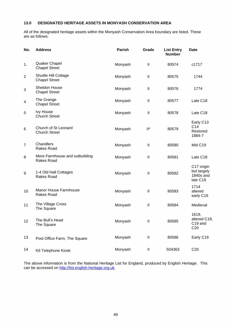
130 DESIGNATED HERITAGE ASSETS IN MONYASH CONSERVATION AREA All of the designated heritage assets within the Monyash Conservation Area boundary are listed These are as follows No Address Parish Grade List Entry
Number Date
1 Quaker Chapel Chapel Street
Monyash II 80574 c1717
2 Shuttle Hill Cottage Chapel Street
Monyash II 80575 1744
3 Sheldon House Chapel Street
Monyash II 80576 1774
4 The Grange Chapel Street
Monyash II 80577 Late C18
5 Ivy House Church Street
Monyash II 80578 Late C18
6 Church of St Leonard Church Street
Monyash II 80579
Early C13 C14
Restored 1884-7
7 Chandlers Rakes Road
Monyash II 80580 Mid C19
8 Mere Farmhouse and outbuilding Rakes Road
Monyash II 80581 Late C18
9 1-4 Old Hall Cottages Rakes Road
Monyash II 80582
C17 origin but largely 1840s and late C19
10 Manor House Farmhouse Rakes Road
Monyash II 80583 1714 altered early C19
11 The Village Cross The Square
Monyash II 80584 Medieval
12 The Bullrsquos Head The Square
Monyash II 80585
1619 altered C18 C19 and C20
13 Post Office Farm The Square Monyash II 80586 Early C19
14 K6 Telephone Kiosk Monyash II 504363 C20
The above information is from the National Heritage List for England produced by English Heritage This can be accessed on httplistenglish-heritageorguk
49
140 GLOSSARY
Agrarian Of the land or its cultivation
Ancillary In architectural terms this usually refers to a secondary structure for instance stables or outbuilding
Ancient Monument Ancient monuments are legally protected archaeological sites and buildings designated under the Ancient Monuments and Archaeological Areas Act 1979 It is an offence to carry out works to them without the written consent of the Secretary of State
Ashlar Masonry that has been carefully cut dressed and squared to be employed as facing stone in finely jointed level courses
Berewick Outlying manorial dependencies belonging to the Lord of the Manor
Coped gables Gable walls that have a course of flat stone laid on top
Chapel-of-ease A place of Christian worship subordinate to or dependent on and distant from a parish church provided for the convenience of parishioners who might not otherwise be able by reason of distance to attend divine service
Chapelry A subdivision of an ecclesiastical parish in England up to the mid-19th century It had a similar status to a township but was so named as it had a chapel which acted as a subsidiary place of worship to the main Parish Church Such chapelries were common in northern England where the Parishes had been established in medieval times when the area was sparsely populated thus obliging parishioners to travel long distances to the parish church A chapelry also had a role in civil government being a subdivision of a parish which was used as a basis for the Poor Law until the establishment of Poor Law Unions in the 19th century
Cruck Frame Constructed primarily in the north and west of England from the medieval period through to the 19th century (Brunskill 2000) This method of timber-framing is based upon two curved timbers known as blades positioned in an A shape These paired timbers are usually cut from a single tree The blades are joined at the apex and roof loads are transferred along roof purlins then directly to the ground via the blades A tie beam and collar assist the restraining of the structure whilst the base of the cruck sits on a soleplate padstones or on a plinth
Curtilage Area attached to a house and forming one enclosure with it
Dormer window Window placed vertically in the sloping plane of a roof (Pevsner 2002)
Double pile plan The building is entirely two rooms in depth (Brunskill 2000)
Drip moulds A horizontal moulding for throwing water off and so protecting the windows immediately below Drip moulds are also used on chimneys
Enclosure Award Between the mid-18th and late-19th centuries a large amount of waste and common land was enclosed in England and Wales This enclosure movement was undertaken under the strong belief in the need for agricultural improvement amongst landowners at the time To enclose land the distribution of the newly enclosed fields had to be approved This approval could be via an Act of Parliament the central courts or private agreement between local landowners In all legally ratified cases and some privately agreed examples an enclosure award setting down the agreed extent and layout of the enclosure in writing and a corresponding plan was drawn up The level of accuracy and detail that allotment boundaries were planned to is usually good but in many cases the subdivisions into individual fields were not shown Their coverage therefore varies from one area to another In the case of Parliamentary Awards these were often done on a parish by parish basis
HER Historic Environment Record (HER) Holloway A sunken track worn down over time with slightly raised sides
Hood mouldings Projecting moulding above an arch or a lintel to throw-off water (Pevsner 2002)
Kirkgate Route or way to the church
Kneeler Horizontal decorative projection at the base of a gable (Pevsner 2002)
Lintel Horizontal beam or stone bridging an opening (Pevsner 2002)
50
Mullion Vertical posts or uprights dividing a window into lsquolightsrsquo (Pevsner 2002) Mullions can be shaped or chamfered which can give an indication as to age
Neolithic The prehistoric period which comes between the Mesolithic (Middle Stone Age) and the Bronze Age dating roughly from 4000 to 2000 BC This was the time of the adoption of the first agricultural practices including cereal cultivation but more importantly the rearing of domesticated animals including herds of cattle and flocks of sheep In the beginning farmers moved around the landscape with their herds much as they had in the Mesolithic (except they took animals with them rather than following wild game) It was only after more than a thousand years that they settled in more lsquopermanentrsquo farms which they surrounded by hedged fields They built impressive ceremonial monuments often used to establish traditional right to the use of land by burying the bones of the ancestors to overlook pastures
Parish The smallest unit of local government is the civil parish In some areas this covers the same area as an ecclesiastical parish which is the area of jurisdiction covered by the parish church Ecclesiastical parishes are almost always the remains of Medieval manors especially in rural areas and many have remained unaltered in their boundaries since the Medieval period However in the Peak District many parishes became defined by the boundaries of Townships
Pediment The classical equivalent of a gable often used without any relation to a roof Often used over an opening particularly doorways
Pinch point A visual effect which suggests a narrowing of the street scene It is typically caused by a bend in a road and the proximity of buildings on either side
Quoins Dressed stones at the (exterior) angles of a building
SBI Site of Biological Importance (SBI) is the name given to the most important non-statutory sites for nature conservation and provides a means of protecting sites that are of local interest and importance
SSSI Site of special scientific interest Sites of national importance for their wildlife or geological interest protected under the Wildlife amp Countryside Act 1981 (and subsequent amendments) Ownersoccupiers must consult Natural England if they wish to carry out operations which might damage the interest of the site and public bodies have a duty to take reasonable steps to further the conservation and enhancement of SSSIs (eg when considering planning issues)
Strip field In the Medieval period from at least as early as 1100 AD Peak District villages were surrounded by large strip fields (often referred to as lsquoopen fieldsrsquo ndash in upland areas it is debatable whether some parts of them remained open for long and thus the term strip field is preferred) While often bounded at their edges by banks and ditches internally they were initially divided into a large number of unfenced cultivation strips The use of strips allowed a fair distribution of different grades of land between lord and villagers This system was designed to favour the needs of arable cultivation It seems to have been introduced into the area from the lowlands of the Midlands In the Peak District pastoral farming was of equal or greater importance and individual strips or parcels of strips were enclosed from an early date Others in less favourable locations in what are known as lsquooutfieldsrsquo may have only been used in an intermittent way
Tithe map Shows the boundaries of land and property within the Tithe area A tithe was a tenth of a personrsquos produce or income given voluntarily or as a tax to the church
Vernacular An indigenous building constructed of locally available materials to local detail without the benefit of an architect Vernacular architecture can be defined as dwellings and lsquoall other buildings of the peoplersquo (Oliver 2003)
51
150 REFERENCES
Bagshawe S (1846) History Gazeteer and Directory of Derbyshire Sheffield
Banks F R (1975) The Peak District Robert Hale amp Co London
Barnatt J amp Smith K (2004) The Peak District Landscapes Through Time Windgather Press Ltd Cheshire
Brunskill R W (2000) Vernacular Architecture Faber and Faber Limited London
Cameron K (1959) The Place Names of Derbyshire Cambridge University Press
Christian R (1980) The Village of Monyash Derbyshire Life August 1980
Derbyshire Record Society (1982) Derbyshire Hearth Tax Assessments 1662-70 Vol VII
Dodd A E and Dodd E M (1990) Peakland Roads and Trackways Ashbourne Moorland Publishing Co Ltd
Hart C R (1981) The North Derbyshire Archaeological Survey to AD 1500 The North Derbyshire Archaeological Trust Chesterfield
Hey D (2001) Packmen Carriers and Packhorse Roads Landmark Publishing Ltd Derbyshire
Johnston R and Johnston S (2010) Monyash The Making of a Derbyshire Village Horizon Editions Ltd Ashbourne
Kelly (1891) Kellyrsquos Directory of Derbyshire
McMeeken LG (1991) A Companion to the Peak Villageshellipand beyond Louis McMeeken Buxton
Mercer E (1975) English Vernacular Houses Royal Commission on Historic Monuments 21
Morris J (1987) Domesday Book - Derbyshire Philip Morgan (ed) Philimore (27) Chichester
Oliver P (2003) Dwellings The Vernacular House World Wide Phaidon London
Pevsner N (2002) The Buildings of England Derbyshire Revised by Elizabeth Williamson Yale University Press
Spray M (1989) Peak District Names JNM Publication
Tarn J N (1971) The Peak District and its Architecture RB Macmillan Ltd Derby
Other Sources Derbyshire County Council () Heritage Environment Record for Derbyshire
Department of the Environment List of Buildings of Special Architectural or Historic Interest Vol 356 District of West Derbyshire Peak District National Park 1985
English Heritage Brock D Architectural Glossary 1984
Peak District National Park Authority Local Plan 2001 Peak District National Park Authority Design Guide 2007 Peak District National Park Authority Historic Landscape Characterisation 1996 Peak District National Park Authority Landscape Strategy and Action Plan 2009
Maps 1776 Map of the Manor of Monyash 1840 Ordnance Survey Map 1848 Tithe Award Plan for Monyash
52
1879 First Edition Ordnance Survey Map 1898 Second Edition Ordnance Survey Map 1994 Ordnance Survey Outdoor Leisure 24 The Peak District Dark Peak Area 125 000
111 The purpose of this Section is to examine the special character and appearance of the Conservation Area and identify opportunities for improvements
112 Monyash village was revitalised in 1981 when the Integrated Rural Development scheme injected new investment and created new opportunities in the village As a result the village hall was built a childrenrsquos play area constructed the school extended buildings restored and businesses helped Grants were provided to maintain the many miles of drystone walls provide water supplies to fields develop flower-rich fields and plant new woodland areas
113 The Conservation Area is in comparatively good condition with few neutral or negative areas or elements requiring enhancement However there are some improvements which could be made if the opportunity were to arise Some of the issues mentioned below could be addressed by the Peak District National Park Authority andor Derbyshire County Council Other items would need to be addressed by private individuals and in some cases enhancement may not be achievable It should be noted that the character of Monyash Conservation Area could easily be spoiled if it were to become over-manicured
Improving modern development
114 In general the small areas of twentieth century housing within Monyash Conservation Area have been constructed relatively sympathetically having a mostly neutral impact on the character of the Conservation Area Any new development needs to be designed with care to ensure that it does not detract from the character of the Conservation Area
Repairing historic buildings and structures
115 Buildings within Monyash Conservation Area are in relatively good condition However buildings need continual maintenance and repairs Listed and other historic properties in the Conservation Area may be entitled to grant-aid from the Authority subject to the eligibility of the proposed work and the availability of resources For further information on grants contact the Authorityrsquos Cultural Heritage team (on 01629 816200) or refer to the Peak District National Park Authorityrsquos website (wwwpeakdistrictgovuk)
116 Traditional stone boundary walls both within the village itself and defining the medieval strip fields surrounding it are of particular importance in the Monyash Conservation Area These should be retained and where necessary repaired 67 of the area covered by the proposed Conservation Area boundary extension
currently falls within agri-environment schemes which afford the walls a degree of protection Some of the field boundary walls may require attention and agri-environment scheme agreements could be one way of improving their condition A general condition survey of these walls could be beneficial in identifying where work is needed
Avoiding unsympathetic repairs and replacement of traditional features
117 Unsympathetic alterations and repairs can have a detrimental impact on a propertyrsquos aesthetic and structural qualities Minor works such as the installation of windows and doors that are inappropriate in design andor materials (eg upvc) or the use of cement-based mortars and strap pointing soon accumulate and erode the special character of a place Within the Monyash Conservation Area many traditional windows and doors have been replaced with upvc and this significantly detracts from the character and integrity of the settlementrsquos historic properties Any owner wishing to replace any type of window should contact the Authorityrsquos Cultural Heritage Team for further advice
118 The use of non-traditional materials such as concrete render and imported andor artificial materials such as concrete roofing tiles and upvc should be avoided as this detracts from the historic character and architectural quality of the buildings The use of modern materials in new developments within the Conservation Area will only be considered in exceptional circumstances In these instances the materials and detailing should be of a high quality
119 Modern boundary types such as timber post and rail or concrete post and timber boarded fences would have a detrimental impact on the character of the Conservation Area and should be avoided
1110 Unsympathetic extensions and additions to a traditional building may not only have a negative impact on the historic quality of the building but can also detract from the character of the Conservation Area at that point
1111 The Authorityrsquos Design Guide has further information on materials alterations extensions and enhancement to unsympathetic developments See the Authorityrsquos website (wwwpeakdistrictgovuk) for further details
1112 Unsympathetically located modern fixtures on prominent elevations and roofs such as satellite dishes roof-lights solar panels and wind turbines can quickly accumulate and have a detrimental impact on the character of the Conservation Area Please check with the Authorityrsquos Planning Service (on 01629 816200) before installing any such item
45
Sustainability
1113 Conservation Areas are inherently supportive of sustainability as they promote the re-use of traditional buildings encourage the use of local materials and repair over replacement and ensure the protection of trees There is always potential to improve sustainability within a Conservation Area This can be achieved by improving the energy efficiency of buildings and reducing their energy consumption and carbon footprint These issues shall be considered in more detail in any future Conservation Area Management Plan
Protecting trees and shrubs
1114 Trees and shrubs make an essential contribution to the character of Monyash and their removal would have a negative impact on the Conservation Area Some hedgerows are protected from destruction or damage under the Hedgerows Regulation 1997 The Town and Country Planning Act 1990 makes special provision for trees in Conservation Areas which are not the subject of Tree Preservation Orders anyone proposing to cut down or carry out work to a tree is required by legislation to give the Planning Authority six weeks notice of their intention to do so The Authorityrsquos Tree Conservation Officer should be contacted (on 01629 816200) before any lopping or felling of trees shrubs or hedges takes place and before carrying out any other work to hedges
Maintaining spaces and streetscape
1115 To the western edge of the car park on Chapel Street is a small dilapidated building the repair of which would enhance this busy public area
1116 Overhead telephone wires have a detrimental impact at various points and the Conservation Area would benefit if these were laid underground
Conserving traditional paving
1117 There is a variety of floor surfaces old and new in the Conservation Area Traditional treatments such as stone kerbs flags steps and stone squeezer stiles survive in some areas but the floor treatment to a majority of the public realm comprises tarmac Wherever possible traditional stone surfaces should be retained and the reinstatement of stone kerbs should be encouraged
Improving lighting
1118 The standard of street lighting in Monyash could be improved Some of the existing lights are in prominent positions in the street
scene and their utilitarian design therefore has a detrimental impact on significant views in a number of places (see P74 P76 and P711) In addition all lighting including street lighting and exterior lighting on residential and business properties should minimise where possible the impact of light pollution as this can detract from the Conservation Area
46
120 PLANNING POLICY
121 The planning policy outlined below was applicable at the date of adoption of the Conservation Area Appraisal Always check to ensure that it is still current
122 The development plan policies affecting the Conservation Area include those in the East Midlands Regional Plan 2009 the adopted Peak District National Park Local Development Framework Core Strategy and the remaining policies of the Peak District National Park Local Plan 2001 as shown in Appendix 2 (Schedule of Policies) in the Local Development Framework Core Strategy
123 When drawing up policies for Conservation Areas the Authority is informed by the Planning (Listed Buildings and Conservation Areas) Act 1990 and Planning Policy Statement 5 (PPS 5) Planning for the Historic Environment The Authority aims to preserve and where possible enhance the character or appearance of Conservation Areas by the prevention of harmful development under East Midlands Regional Plan Policies 26 and 27 and Local Plan Policy LC5
124 Development within Conservation Areas is controlled by the Planning (Listed Buildings and Conservation Areas) Act 1990 the Town and Country Planning (General Permitted Development) Order 1995 and the Town and Country Planning (General Permitted Development) (Amendment) (No2) (England) Order 2008 There are currently no Article 4 Directions removing certain permitted development rights in Monyash Conservation Area Assessment of any development proposals will take place within the context of approved development plan policies and this Conservation Area Appraisal
125 PPS 5 sets out the Governmentrsquos objectives for the historic environment and the reasons for its conservation PPS 5 is dominant in plan making and individual planning decisions Through this planning process we can identify and define the interest and character that the historic environment brings to the area and conserve that value An arearsquos heritage can also provide a reference point for the design of new development Assessment of any development proposal will take place in the context of PPS 5 policies and the developerrsquos assessment statement on the effect on the historic asset
126 The Local Plan has identified Monyash as a Local Plan Settlement (LC2) and in the Core Strategy DS1 as a settlement where there is a presumption in favour of residential development necessary for relocation of non-conforming uses or which would enhance the valued characteristics of the National Park
127 The Core Strategy policy RT1 explains the scope for development proposed for recreational environmental education and interpretation Policy RT1 replaces the Recreation zoning policy of the Local Plan and more emphasis will be placed on the Landscape Strategy to determine whether proposals for development for recreation are appropriate With regard to car parks LT14 Parking Strategy and Parking Charges will also apply 128 The Core Strategy will be supplemented in 2013 by a Development Management Policies document This will replace the remaining policies of the 2001 Local Plan Where any conflict exists between the Core Strategy and any remaining Local Plan policies the Core Strategy will take precedence
129 There are 14 listed buildings and structures in Monyash Conservation Area Development that affects the character of these historic assets shall be assessed against national guidance and policies LC6 and LC7 Additionally the proposed conversion of any building of historic or vernacular merit within a Conservation Area will have to take into consideration the points set out in policy LC8
1210 10 sites in Monyash Conservation Area appear on Derbyshire County Councilrsquos Historic Environment Record (HER) with a further HER included within the proposed extension to the Conservation Area Boundary (see Section 31) Development affecting these sites or any other area of archaeological potential will only be permitted if in line with policies LC15 LC16 and C10 Where development has been permitted the developer will be required to minimise its impact and as appropriate to record safeguard and enhance the sites or features of special importance Appropriate schemes for archaeological investigation prior to and during development will also normally be required
1211 A number of sites around Monyash Conservation Area are of regional importance for their biological and wildlife interest Local Plan Policy LC17 states that development which would detrimentally affect the value to wildlife will not be permitted other than in exceptional circumstances
1212 It is possible that protected species as identified in the Wildlife and Countryside Act 1981 (as amended) may be found Development proposals may therefore require specialised surveys such as bat surveys as part of a planning application Trees particularly mature trees may include features suitable for roosting bats and developments leading to the loss of mature trees may also require a bat survey Water voles should be considered when completing any works in the vicinity of watercourses within the Conservation Area
47
1213 Development proposals for areas where protected species exist should also include and implement a scheme for safeguarding the future survival of the protected species and their habitat This will be a requisite condition of any relevant planning permission For further information see the Authorityrsquos Planning Practice Note Protected Species and Development in the Peak District National Park or see the Authorityrsquos website (wwwpeakdistrictgovuk)
1214 In the Conservation Area trees with a trunk over 75cm in diameter are protected and the felling lopping or topping of these trees may not be permitted without prior agreement Some hedgerows are protected from destruction or damage under the Hedgerows Regulation 1997 Anyone considering work of this nature should contact the National Park Authority for advice
1215 All wild birds with the exception of those defined as game or pest species are also protected under the Wildlife and Countryside Act 1981 (as amended) Natural England therefore recommends that lsquoNo tree or shrub clearance works shall be undertaken during the main bird breeding season (mid March to July inclusive)rsquo This condition will normally be attached to planning permissions that require tree shrub and hedgerow removal Development proposals for areas where protected bird species exist must include and implement a scheme for safeguarding the future survival of the protected bird species and their habitat as a requisite condition of any planning permission Development proposals affecting habitats of importance are covered by East Midlands Regional Plan policies 26 29 and 30 and Local Plan policies LC17 and LC20
1216 Monyash is situated on the B5055 which is part of the Secondary Road Network Local Plan policies LT1 and LT2 state that the Authority will discourage the use of the lowest category of roads in favour of strategic and secondary routes East Midlands Regional Plan Policies 43 and 44 will also apply
1217 Although not classified as Policy the Authority has published a number of documents that recommend directly or indirectly actions to safeguard the character of the Monyash Conservation Area These include the Cultural Heritage Strategy (2005) and the Landscape Strategy and Action Plan (2009) The Peak District National Parkrsquos Climate Change Action Plan 2009-2011 which addresses energy conservation and climate change within the Park is also of relevance (wwwpeakdistrictgovukclimatechange)
48
130 DESIGNATED HERITAGE ASSETS IN MONYASH CONSERVATION AREA All of the designated heritage assets within the Monyash Conservation Area boundary are listed These are as follows No Address Parish Grade List Entry
Number Date
1 Quaker Chapel Chapel Street
Monyash II 80574 c1717
2 Shuttle Hill Cottage Chapel Street
Monyash II 80575 1744
3 Sheldon House Chapel Street
Monyash II 80576 1774
4 The Grange Chapel Street
Monyash II 80577 Late C18
5 Ivy House Church Street
Monyash II 80578 Late C18
6 Church of St Leonard Church Street
Monyash II 80579
Early C13 C14
Restored 1884-7
7 Chandlers Rakes Road
Monyash II 80580 Mid C19
8 Mere Farmhouse and outbuilding Rakes Road
Monyash II 80581 Late C18
9 1-4 Old Hall Cottages Rakes Road
Monyash II 80582
C17 origin but largely 1840s and late C19
10 Manor House Farmhouse Rakes Road
Monyash II 80583 1714 altered early C19
11 The Village Cross The Square
Monyash II 80584 Medieval
12 The Bullrsquos Head The Square
Monyash II 80585
1619 altered C18 C19 and C20
13 Post Office Farm The Square Monyash II 80586 Early C19
14 K6 Telephone Kiosk Monyash II 504363 C20
The above information is from the National Heritage List for England produced by English Heritage This can be accessed on httplistenglish-heritageorguk
49
140 GLOSSARY
Agrarian Of the land or its cultivation
Ancillary In architectural terms this usually refers to a secondary structure for instance stables or outbuilding
Ancient Monument Ancient monuments are legally protected archaeological sites and buildings designated under the Ancient Monuments and Archaeological Areas Act 1979 It is an offence to carry out works to them without the written consent of the Secretary of State
Ashlar Masonry that has been carefully cut dressed and squared to be employed as facing stone in finely jointed level courses
Berewick Outlying manorial dependencies belonging to the Lord of the Manor
Coped gables Gable walls that have a course of flat stone laid on top
Chapel-of-ease A place of Christian worship subordinate to or dependent on and distant from a parish church provided for the convenience of parishioners who might not otherwise be able by reason of distance to attend divine service
Chapelry A subdivision of an ecclesiastical parish in England up to the mid-19th century It had a similar status to a township but was so named as it had a chapel which acted as a subsidiary place of worship to the main Parish Church Such chapelries were common in northern England where the Parishes had been established in medieval times when the area was sparsely populated thus obliging parishioners to travel long distances to the parish church A chapelry also had a role in civil government being a subdivision of a parish which was used as a basis for the Poor Law until the establishment of Poor Law Unions in the 19th century
Cruck Frame Constructed primarily in the north and west of England from the medieval period through to the 19th century (Brunskill 2000) This method of timber-framing is based upon two curved timbers known as blades positioned in an A shape These paired timbers are usually cut from a single tree The blades are joined at the apex and roof loads are transferred along roof purlins then directly to the ground via the blades A tie beam and collar assist the restraining of the structure whilst the base of the cruck sits on a soleplate padstones or on a plinth
Curtilage Area attached to a house and forming one enclosure with it
Dormer window Window placed vertically in the sloping plane of a roof (Pevsner 2002)
Double pile plan The building is entirely two rooms in depth (Brunskill 2000)
Drip moulds A horizontal moulding for throwing water off and so protecting the windows immediately below Drip moulds are also used on chimneys
Enclosure Award Between the mid-18th and late-19th centuries a large amount of waste and common land was enclosed in England and Wales This enclosure movement was undertaken under the strong belief in the need for agricultural improvement amongst landowners at the time To enclose land the distribution of the newly enclosed fields had to be approved This approval could be via an Act of Parliament the central courts or private agreement between local landowners In all legally ratified cases and some privately agreed examples an enclosure award setting down the agreed extent and layout of the enclosure in writing and a corresponding plan was drawn up The level of accuracy and detail that allotment boundaries were planned to is usually good but in many cases the subdivisions into individual fields were not shown Their coverage therefore varies from one area to another In the case of Parliamentary Awards these were often done on a parish by parish basis
HER Historic Environment Record (HER) Holloway A sunken track worn down over time with slightly raised sides
Hood mouldings Projecting moulding above an arch or a lintel to throw-off water (Pevsner 2002)
Kirkgate Route or way to the church
Kneeler Horizontal decorative projection at the base of a gable (Pevsner 2002)
Lintel Horizontal beam or stone bridging an opening (Pevsner 2002)
50
Mullion Vertical posts or uprights dividing a window into lsquolightsrsquo (Pevsner 2002) Mullions can be shaped or chamfered which can give an indication as to age
Neolithic The prehistoric period which comes between the Mesolithic (Middle Stone Age) and the Bronze Age dating roughly from 4000 to 2000 BC This was the time of the adoption of the first agricultural practices including cereal cultivation but more importantly the rearing of domesticated animals including herds of cattle and flocks of sheep In the beginning farmers moved around the landscape with their herds much as they had in the Mesolithic (except they took animals with them rather than following wild game) It was only after more than a thousand years that they settled in more lsquopermanentrsquo farms which they surrounded by hedged fields They built impressive ceremonial monuments often used to establish traditional right to the use of land by burying the bones of the ancestors to overlook pastures
Parish The smallest unit of local government is the civil parish In some areas this covers the same area as an ecclesiastical parish which is the area of jurisdiction covered by the parish church Ecclesiastical parishes are almost always the remains of Medieval manors especially in rural areas and many have remained unaltered in their boundaries since the Medieval period However in the Peak District many parishes became defined by the boundaries of Townships
Pediment The classical equivalent of a gable often used without any relation to a roof Often used over an opening particularly doorways
Pinch point A visual effect which suggests a narrowing of the street scene It is typically caused by a bend in a road and the proximity of buildings on either side
Quoins Dressed stones at the (exterior) angles of a building
SBI Site of Biological Importance (SBI) is the name given to the most important non-statutory sites for nature conservation and provides a means of protecting sites that are of local interest and importance
SSSI Site of special scientific interest Sites of national importance for their wildlife or geological interest protected under the Wildlife amp Countryside Act 1981 (and subsequent amendments) Ownersoccupiers must consult Natural England if they wish to carry out operations which might damage the interest of the site and public bodies have a duty to take reasonable steps to further the conservation and enhancement of SSSIs (eg when considering planning issues)
Strip field In the Medieval period from at least as early as 1100 AD Peak District villages were surrounded by large strip fields (often referred to as lsquoopen fieldsrsquo ndash in upland areas it is debatable whether some parts of them remained open for long and thus the term strip field is preferred) While often bounded at their edges by banks and ditches internally they were initially divided into a large number of unfenced cultivation strips The use of strips allowed a fair distribution of different grades of land between lord and villagers This system was designed to favour the needs of arable cultivation It seems to have been introduced into the area from the lowlands of the Midlands In the Peak District pastoral farming was of equal or greater importance and individual strips or parcels of strips were enclosed from an early date Others in less favourable locations in what are known as lsquooutfieldsrsquo may have only been used in an intermittent way
Tithe map Shows the boundaries of land and property within the Tithe area A tithe was a tenth of a personrsquos produce or income given voluntarily or as a tax to the church
Vernacular An indigenous building constructed of locally available materials to local detail without the benefit of an architect Vernacular architecture can be defined as dwellings and lsquoall other buildings of the peoplersquo (Oliver 2003)
51
150 REFERENCES
Bagshawe S (1846) History Gazeteer and Directory of Derbyshire Sheffield
Banks F R (1975) The Peak District Robert Hale amp Co London
Barnatt J amp Smith K (2004) The Peak District Landscapes Through Time Windgather Press Ltd Cheshire
Brunskill R W (2000) Vernacular Architecture Faber and Faber Limited London
Cameron K (1959) The Place Names of Derbyshire Cambridge University Press
Christian R (1980) The Village of Monyash Derbyshire Life August 1980
Derbyshire Record Society (1982) Derbyshire Hearth Tax Assessments 1662-70 Vol VII
Dodd A E and Dodd E M (1990) Peakland Roads and Trackways Ashbourne Moorland Publishing Co Ltd
Hart C R (1981) The North Derbyshire Archaeological Survey to AD 1500 The North Derbyshire Archaeological Trust Chesterfield
Hey D (2001) Packmen Carriers and Packhorse Roads Landmark Publishing Ltd Derbyshire
Johnston R and Johnston S (2010) Monyash The Making of a Derbyshire Village Horizon Editions Ltd Ashbourne
Kelly (1891) Kellyrsquos Directory of Derbyshire
McMeeken LG (1991) A Companion to the Peak Villageshellipand beyond Louis McMeeken Buxton
Mercer E (1975) English Vernacular Houses Royal Commission on Historic Monuments 21
Morris J (1987) Domesday Book - Derbyshire Philip Morgan (ed) Philimore (27) Chichester
Oliver P (2003) Dwellings The Vernacular House World Wide Phaidon London
Pevsner N (2002) The Buildings of England Derbyshire Revised by Elizabeth Williamson Yale University Press
Spray M (1989) Peak District Names JNM Publication
Tarn J N (1971) The Peak District and its Architecture RB Macmillan Ltd Derby
Other Sources Derbyshire County Council () Heritage Environment Record for Derbyshire
Department of the Environment List of Buildings of Special Architectural or Historic Interest Vol 356 District of West Derbyshire Peak District National Park 1985
English Heritage Brock D Architectural Glossary 1984
Peak District National Park Authority Local Plan 2001 Peak District National Park Authority Design Guide 2007 Peak District National Park Authority Historic Landscape Characterisation 1996 Peak District National Park Authority Landscape Strategy and Action Plan 2009
Maps 1776 Map of the Manor of Monyash 1840 Ordnance Survey Map 1848 Tithe Award Plan for Monyash
52
1879 First Edition Ordnance Survey Map 1898 Second Edition Ordnance Survey Map 1994 Ordnance Survey Outdoor Leisure 24 The Peak District Dark Peak Area 125 000
1879 First Edition Ordnance Survey Map 1898 Second Edition Ordnance Survey Map 1994 Ordnance Survey Outdoor Leisure 24 The Peak District Dark Peak Area 125 000