2021 Merced County Hazard Mitigation Plan Annex E: City of Los Banos Merced County Hazard Mitigation Plan Update | 2021 – 2026 Page 1 1 CITY OF LOS BANOS 1.1 Community Profile 1.1.1 Mitigation Planning History and 2021 Process This annex was updated during the development of the 2021 Merced County Hazard Mitigation Plan update. This Jurisdictional Annex builds upon the previous version of Los Banos Annex as part of the 2014 Merced County Multi-Jurisdictional Plan. A review of jurisdictional priorities found no significant changes in priorities since the last update. The City’s Local Planning Team (LPT) held the responsibility for implementation and maintenance of the plan. Members are listed in Appendix A. More details on the planning process follow and how the jurisdictions, service districts and stakeholders participated can be found in Section 3 Planning Process of the Base Plan, along with how the public was involved during the 2021 update. 1.1.2 Geography and Climate The City of Los Banos in Merced County is situated 12 miles southwest of the City of Merced, the county seat. Los Banos is one of the larger cities in the County of Merced and is in the heart of the San Joaquin Valley, 70 miles northwest of Fresno. Los Banos is in the center of California, about two hours from the cities of San Francisco, Oakland, Sacramento, and Yosemite National Park. Monterey and San Jose are accessible in one and a half hours and within one hour of San Joaquin’s Valley’s major cities of Stockton and Fresno. The City is located in the western portion of the County west of Highway 165 and just north of Highway 152. Some have called Los Banos "The Crossroads" because State Highways 33, 152, and 165 pass through the City; Interstate 5 skirts its western boundaries and it’s an easy 30 minute drive to Highway 99. According to the United States Census Bureau, Los Banos has a total area of 10.12 square miles – 98.78% of it is land and 1.22% is water with an elevation of 118 feet above sea level. The climate in the City of Los Banos is characterized by summers which are hot and dry and cool, wet winters, with most of the year’s rain falling from late December through March. The annual average precipitation for the City of Los Banos is 9.1 inches with the most precipitation, on average, occurring in January. The warmest month of the year on average is July. The highest recorded temperature was 112°F in 2006. On average, the coolest month of the year is January. The lowest recorded temperature was 13°F in 2007. 1.1.3 History The name “Los Banos” came from a Franciscan monk’s missionary trips to the valley from Mission San Juan Bautista back in the early 1800’s. On the route from San Juan Bautista, Padre Felipe Arroyo de la Cuesta discovered pools of water in the rocks at the summit of the mountains in a little creek bed that flowed down into the San Joaquin Valley. At these baths or pools he camped overnight with his band of friendly Indians from the Mission. Reports of these baths led to the local ranchers naming the creek "El Arroyo de Los Banos del Padre Arroyo." The name of those spring baths became "Los Banos Crick." In 1873 a pioneer to the area named Gus Kreyenhagen ran a trading post near Los Banos Creek. The Post Office Department decided to establish a Post Office at the trading post and named it after the creek, hence the name “Los Banos.” Henry Miller arrived in San Francisco in 1850 with $6.00 in his pocket. After working as a butcher, he became aware of the need for a better grade of cattle than that which was available at that time in California. He came to the San Joaquin Valley and began his land acquisitions and
Transcript
2021 Merced County Hazard Mitigation Plan Annex E: City of Los Banos
Merced County Hazard Mitigation Plan Update | 2021 – 2026 Page 1
1 CITY OF LOS BANOS
1.1 Community Profile
1.1.1 Mitigation Planning History and 2021 Process This annex was updated during the development of the 2021 Merced County Hazard Mitigation Plan update. This Jurisdictional Annex builds upon the previous version of Los Banos Annex as part of the 2014 Merced County Multi-Jurisdictional Plan. A review of jurisdictional priorities found no significant changes in priorities since the last update.
The City’s Local Planning Team (LPT) held the responsibility for implementation and maintenance of the plan. Members are listed in Appendix A. More details on the planning process follow and how the jurisdictions, service districts and stakeholders participated can be found in Section 3 Planning Process of the Base Plan, along with how the public was involved during the 2021 update.
1.1.2 Geography and Climate The City of Los Banos in Merced County is situated 12 miles southwest of the City of Merced, the county seat. Los Banos is one of the larger cities in the County of Merced and is in the heart of the San Joaquin Valley, 70 miles northwest of Fresno. Los Banos is in the center of California, about two hours from the cities of San Francisco, Oakland, Sacramento, and Yosemite National Park. Monterey and San Jose are accessible in one and a half hours and within one hour of San Joaquin’s Valley’s major cities of Stockton and Fresno. The City is located in the western portion of the County west of Highway 165 and just north of Highway 152. Some have called Los Banos "The Crossroads" because State Highways 33, 152, and 165 pass through the City; Interstate 5 skirts its western boundaries and it’s an easy 30 minute drive to Highway 99. According to the United States Census Bureau, Los Banos has a total area of 10.12 square miles – 98.78% of it is land and 1.22% is water with an elevation of 118 feet above sea level.
The climate in the City of Los Banos is characterized by summers which are hot and dry and cool, wet winters, with most of the year’s rain falling from late December through March.
The annual average precipitation for the City of Los Banos is 9.1 inches with the most precipitation, on average, occurring in January. The warmest month of the year on average is July. The highest recorded temperature was 112°F in 2006. On average, the coolest month of the year is January. The lowest recorded temperature was 13°F in 2007.
1.1.3 History The name “Los Banos” came from a Franciscan monk’s missionary trips to the valley from Mission San Juan Bautista back in the early 1800’s. On the route from San Juan Bautista, Padre Felipe Arroyo de la Cuesta discovered pools of water in the rocks at the summit of the mountains in a little creek bed that flowed down into the San Joaquin Valley. At these baths or pools he camped overnight with his band of friendly Indians from the Mission. Reports of these baths led to the local ranchers naming the creek "El Arroyo de Los Banos del Padre Arroyo." The name of those spring baths became "Los Banos Crick."
In 1873 a pioneer to the area named Gus Kreyenhagen ran a trading post near Los Banos Creek. The Post Office Department decided to establish a Post Office at the trading post and named it after the creek, hence the name “Los Banos.” Henry Miller arrived in San Francisco in 1850 with $6.00 in his pocket. After working as a butcher, he became aware of the need for a better grade of cattle than that which was available at that time in California. He came to the San Joaquin Valley and began his land acquisitions and
2021 Merced County Hazard Mitigation Plan Annex E: City of Los Banos
Merced County Hazard Mitigation Plan Update | 2021 – 2026 Page 2
cattle empire. He acquired land on both sides of the San Joaquin River ultimately owning that land for a distance of 120 miles. In 1871 he formed the San Joaquin and Kings River Canal and Irrigation Company. He is credited with being the first to introduce the crops of cotton, rice and alfalfa to the valley. Agriculture remains the number one industry in and around Los Banos and this is due mainly to the early success of Henry Miller. He owned over 3,000,000 acres of land, stretching through Idaho, Oregon, Nevada and California. In Los Banos, Miller brought the railroad to town, constructed a bank, company store and many other building improvements. In addition, he planned and developed housing areas for local citizens and enhanced the quality of life in many ways. Miller created the May Day celebration, which still is observed in Los Banos, as a way of thanking his employees for their hard work and dedication. By the age of 89, when Henry Miller died in 1916, he had given millions of dollars to numerous worthy causes. Today the City of Los Banos is proud to honor his vision and legacy.
1.1.4 Economy The City of Los Banos’ vision is to be a family-oriented community that maintains its small-town atmosphere while accommodating growth. Traditionally, the City of Los Banos has attracted agricultural‐based industries and has relied on these types of industries for employment.
Through a collaborative effort of the County of Merced, cities of Atwater, Dos Palos, Gustine, Livingston, Los Banos, Merced, and Merced County, the Merced County Economic Development Team, prepared a Comprehensive Economic Development Strategy (CEDS) adopted in May 2014. The Merced County Economic Development Team developed a strategic plan which engaged the county, cities, and other organizations in Merced County in developing an economic development strategic action plan with priority activities and projects. The adopted CEDS met the requirements of the Economic Development Administration (EDA) requirements and aligned with the goals and objectives adopted in the City of Los Banos General Plan.
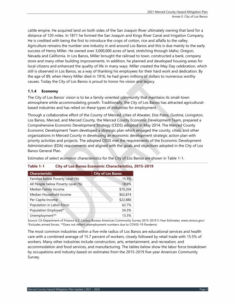
Estimates of select economic characteristics for the City of Los Banos are shown in Table 1-1.
Table 1‐1 City of Los Banos Economic Characteristics, 2015‐2019
Characteristic City of Los Banos Families below Poverty Level (%) 15.3% All People below Poverty Level (%) 18.0% Median Family Income $70,204 Median Household Income $62,874 Per Capita Income $22,880 Population in Labor Force 62.7% Population Employed* 54.3% Unemployment** 13.3%
Source: CA Department of Finance U.S. Census Bureau American Community Survey 2015-2019 5-Year Estimates, www.census.gov/ *Excludes armed forces. **Does not reflect unemployment numbers due to COVID-19 Pandemic
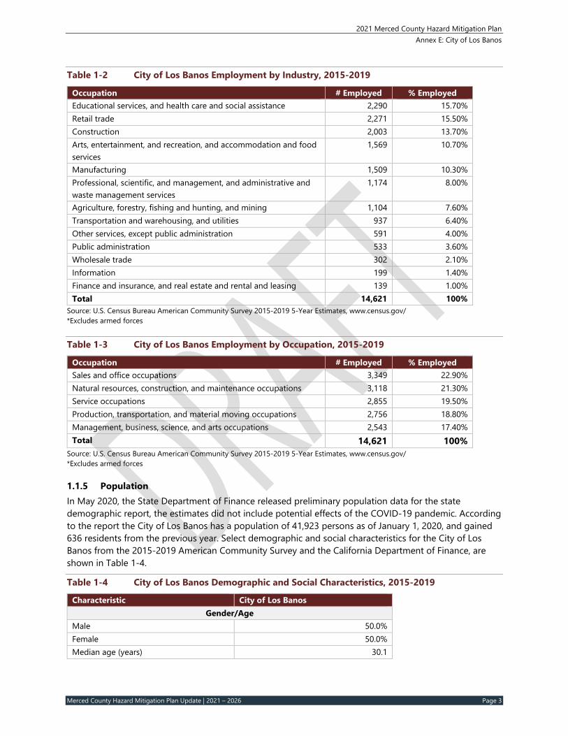
The most common industries within a five-mile radius of Los Banos are educational services and health care with a combined average of 15.7 percent of workers, closely followed by retail trade with 15.5% of workers. Many other industries include construction, arts, entertainment, and recreation, and accommodation and food services, and manufacturing. The tables below show the labor force breakdown by occupations and industry based on estimates from the 2015-2019 five-year American Community Survey.
2021 Merced County Hazard Mitigation Plan Annex E: City of Los Banos
Merced County Hazard Mitigation Plan Update | 2021 – 2026 Page 3
Table 1‐2 City of Los Banos Employment by Industry, 2015‐2019
Occupation # Employed % Employed Educational services, and health care and social assistance 2,290 15.70% Retail trade 2,271 15.50% Construction 2,003 13.70% Arts, entertainment, and recreation, and accommodation and food services
1,569 10.70%
Manufacturing 1,509 10.30% Professional, scientific, and management, and administrative and waste management services
1,174 8.00%
Agriculture, forestry, fishing and hunting, and mining 1,104 7.60% Transportation and warehousing, and utilities 937 6.40% Other services, except public administration 591 4.00% Public administration 533 3.60% Wholesale trade 302 2.10% Information 199 1.40% Finance and insurance, and real estate and rental and leasing 139 1.00% Total 14,621 100%
Source: U.S. Census Bureau American Community Survey 2015-2019 5-Year Estimates, www.census.gov/ *Excludes armed forces
Table 1‐3 City of Los Banos Employment by Occupation, 2015‐2019
Occupation # Employed % Employed Sales and office occupations 3,349 22.90% Natural resources, construction, and maintenance occupations 3,118 21.30% Service occupations 2,855 19.50% Production, transportation, and material moving occupations 2,756 18.80% Management, business, science, and arts occupations 2,543 17.40% Total 14,621 100%
Source: U.S. Census Bureau American Community Survey 2015-2019 5-Year Estimates, www.census.gov/ *Excludes armed forces
1.1.5 Population In May 2020, the State Department of Finance released preliminary population data for the state demographic report, the estimates did not include potential effects of the COVID-19 pandemic. According to the report the City of Los Banos has a population of 41,923 persons as of January 1, 2020, and gained 636 residents from the previous year. Select demographic and social characteristics for the City of Los Banos from the 2015-2019 American Community Survey and the California Department of Finance, are shown in Table 1-4.
Table 1‐4 City of Los Banos Demographic and Social Characteristics, 2015‐2019
Characteristic City of Los Banos Gender/Age
Male 50.0% Female 50.0% Median age (years) 30.1
2021 Merced County Hazard Mitigation Plan Annex E: City of Los Banos
Merced County Hazard Mitigation Plan Update | 2021 – 2026 Page 4
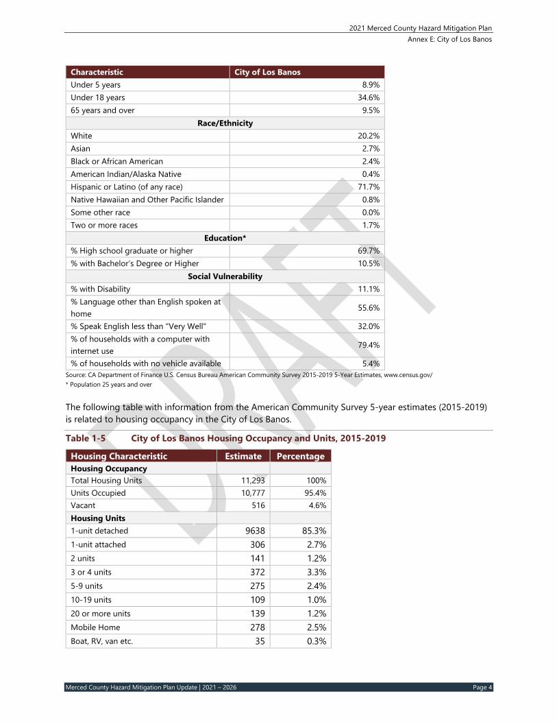
Characteristic City of Los Banos Under 5 years 8.9% Under 18 years 34.6% 65 years and over 9.5%
Race/Ethnicity White 20.2% Asian 2.7% Black or African American 2.4% American Indian/Alaska Native 0.4% Hispanic or Latino (of any race) 71.7% Native Hawaiian and Other Pacific Islander 0.8% Some other race 0.0% Two or more races 1.7%
Education* % High school graduate or higher 69.7% % with Bachelor’s Degree or Higher 10.5%
Social Vulnerability % with Disability 11.1% % Language other than English spoken at home
55.6%
% Speak English less than "Very Well" 32.0% % of households with a computer with internet use
79.4%
% of households with no vehicle available 5.4% Source: CA Department of Finance U.S. Census Bureau American Community Survey 2015-2019 5-Year Estimates, www.census.gov/ * Population 25 years and over
The following table with information from the American Community Survey 5-year estimates (2015-2019) is related to housing occupancy in the City of Los Banos.
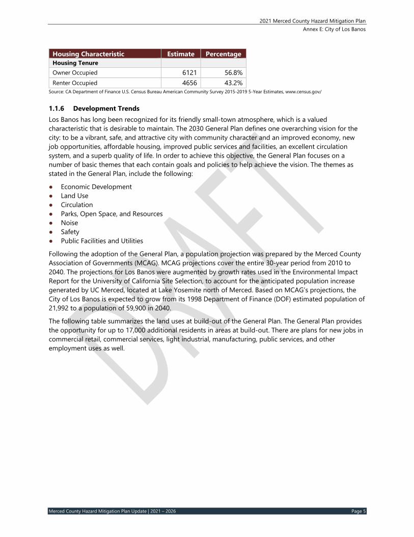
Table 1‐5 City of Los Banos Housing Occupancy and Units, 2015‐2019
Housing Characteristic Estimate Percentage Housing Occupancy Total Housing Units 11,293 100% Units Occupied 10,777 95.4% Vacant 516 4.6% Housing Units 1-unit detached 9638 85.3% 1-unit attached 306 2.7% 2 units 141 1.2% 3 or 4 units 372 3.3% 5-9 units 275 2.4% 10-19 units 109 1.0% 20 or more units 139 1.2% Mobile Home 278 2.5% Boat, RV, van etc. 35 0.3%
2021 Merced County Hazard Mitigation Plan Annex E: City of Los Banos
Merced County Hazard Mitigation Plan Update | 2021 – 2026 Page 5
Source: CA Department of Finance U.S. Census Bureau American Community Survey 2015-2019 5-Year Estimates, www.census.gov/
1.1.6 Development Trends Los Banos has long been recognized for its friendly small-town atmosphere, which is a valued characteristic that is desirable to maintain. The 2030 General Plan defines one overarching vision for the city: to be a vibrant, safe, and attractive city with community character and an improved economy, new job opportunities, affordable housing, improved public services and facilities, an excellent circulation system, and a superb quality of life. In order to achieve this objective, the General Plan focuses on a number of basic themes that each contain goals and policies to help achieve the vision. The themes as stated in the General Plan, include the following:
● Economic Development ● Land Use ● Circulation ● Parks, Open Space, and Resources ● Noise ● Safety ● Public Facilities and Utilities
Following the adoption of the General Plan, a population projection was prepared by the Merced County Association of Governments (MCAG). MCAG projections cover the entire 30-year period from 2010 to 2040. The projections for Los Banos were augmented by growth rates used in the Environmental Impact Report for the University of California Site Selection, to account for the anticipated population increase generated by UC Merced, located at Lake Yosemite north of Merced. Based on MCAG’s projections, the City of Los Banos is expected to grow from its 1998 Department of Finance (DOF) estimated population of 21,992 to a population of 59,900 in 2040.
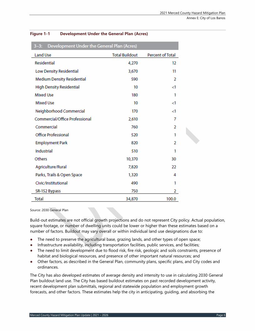
The following table summarizes the land uses at build-out of the General Plan. The General Plan provides the opportunity for up to 17,000 additional residents in areas at build-out. There are plans for new jobs in commercial retail, commercial services, light industrial, manufacturing, public services, and other employment uses as well.
2021 Merced County Hazard Mitigation Plan Annex E: City of Los Banos
Merced County Hazard Mitigation Plan Update | 2021 – 2026 Page 6
Figure 1‐1 Development Under the General Plan (Acres)
Source: 2030 General Plan
Build-out estimates are not official growth projections and do not represent City policy. Actual population, square footage, or number of dwelling units could be lower or higher than these estimates based on a number of factors. Buildout may vary overall or within individual land use designations due to:
● The need to preserve the agricultural base, grazing lands, and other types of open space; ● Infrastructure availability, including transportation facilities, public services, and facilities; ● The need to limit development due to flood risk, fire risk, geologic and soils constraints, presence of
habitat and biological resources, and presence of other important natural resources; and ● Other factors, as described in the General Plan, community plans, specific plans, and City codes and
ordinances.
The City has also developed estimates of average density and intensity to use in calculating 2030 General Plan buildout land use. The City has based buildout estimates on past recorded development activity, recent development plan submittals, regional and statewide population and employment growth forecasts, and other factors. These estimates help the city in anticipating, guiding, and absorbing the
2021 Merced County Hazard Mitigation Plan Annex E: City of Los Banos
Merced County Hazard Mitigation Plan Update | 2021 – 2026 Page 7
pressures of future growth in the coming decades. The city is currently in the process of an update to the General Plan looking out to 2040, with a target of plan adoption in 2021.
2 HAZARD IDENTIFICATION AND SUMMARY
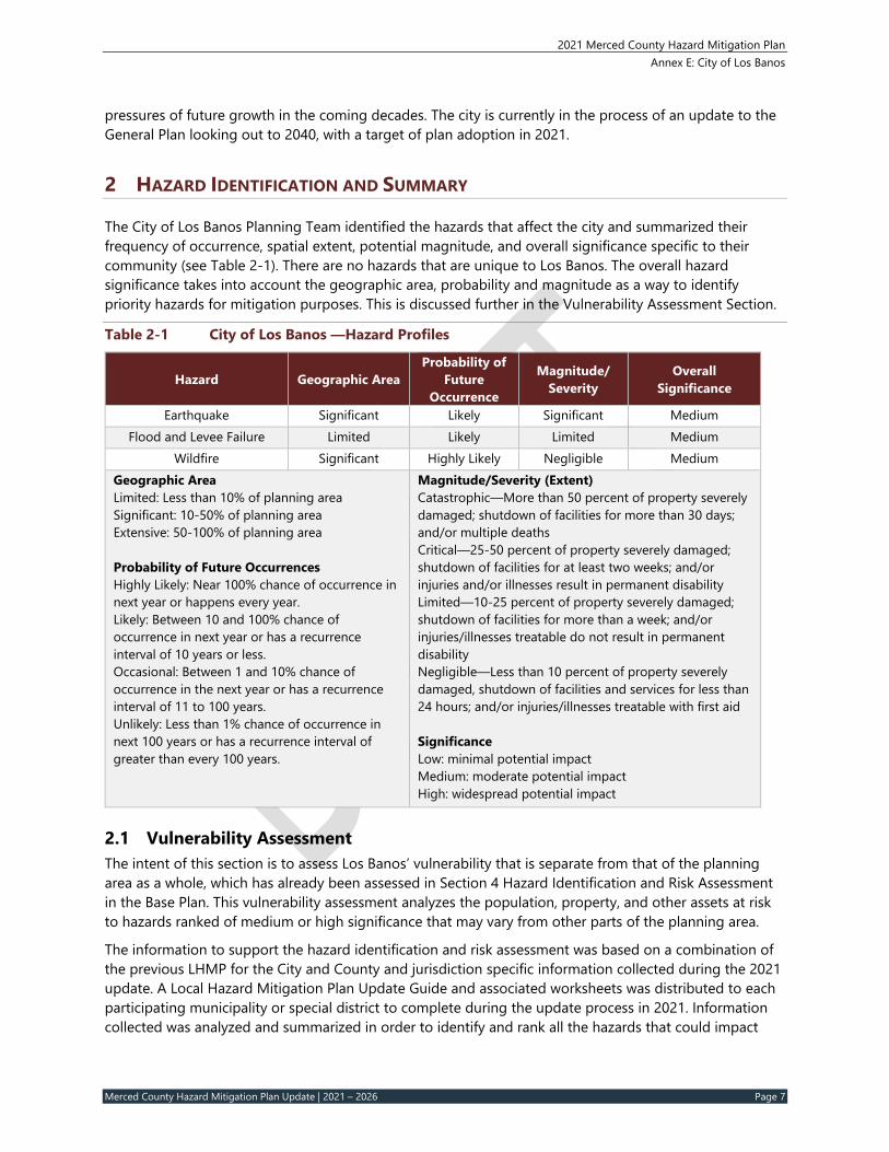
The City of Los Banos Planning Team identified the hazards that affect the city and summarized their frequency of occurrence, spatial extent, potential magnitude, and overall significance specific to their community (see Table 2-1). There are no hazards that are unique to Los Banos. The overall hazard significance takes into account the geographic area, probability and magnitude as a way to identify priority hazards for mitigation purposes. This is discussed further in the Vulnerability Assessment Section.
Table 2‐1 City of Los Banos —Hazard Profiles
Hazard Geographic Area Probability of
Future Occurrence
Magnitude/ Severity
Overall Significance
Earthquake Significant Likely Significant Medium Flood and Levee Failure Limited Likely Limited Medium
Wildfire Significant Highly Likely Negligible Medium Geographic Area Limited: Less than 10% of planning area Significant: 10-50% of planning area Extensive: 50-100% of planning area Probability of Future Occurrences Highly Likely: Near 100% chance of occurrence in next year or happens every year. Likely: Between 10 and 100% chance of occurrence in next year or has a recurrence interval of 10 years or less. Occasional: Between 1 and 10% chance of occurrence in the next year or has a recurrence interval of 11 to 100 years. Unlikely: Less than 1% chance of occurrence in next 100 years or has a recurrence interval of greater than every 100 years.
Magnitude/Severity (Extent) Catastrophic—More than 50 percent of property severely damaged; shutdown of facilities for more than 30 days; and/or multiple deaths Critical—25-50 percent of property severely damaged; shutdown of facilities for at least two weeks; and/or injuries and/or illnesses result in permanent disability Limited—10-25 percent of property severely damaged; shutdown of facilities for more than a week; and/or injuries/illnesses treatable do not result in permanent disability Negligible—Less than 10 percent of property severely damaged, shutdown of facilities and services for less than 24 hours; and/or injuries/illnesses treatable with first aid Significance Low: minimal potential impact Medium: moderate potential impact High: widespread potential impact
2.1 Vulnerability Assessment The intent of this section is to assess Los Banos’ vulnerability that is separate from that of the planning area as a whole, which has already been assessed in Section 4 Hazard Identification and Risk Assessment in the Base Plan. This vulnerability assessment analyzes the population, property, and other assets at risk to hazards ranked of medium or high significance that may vary from other parts of the planning area.
The information to support the hazard identification and risk assessment was based on a combination of the previous LHMP for the City and County and jurisdiction specific information collected during the 2021 update. A Local Hazard Mitigation Plan Update Guide and associated worksheets was distributed to each participating municipality or special district to complete during the update process in 2021. Information collected was analyzed and summarized in order to identify and rank all the hazards that could impact
2021 Merced County Hazard Mitigation Plan Annex E: City of Los Banos
Merced County Hazard Mitigation Plan Update | 2021 – 2026 Page 8
anywhere within the County, as well as to rank the hazards and identify the related vulnerabilities unique to each jurisdiction.
Each participating jurisdiction was in support of the main hazard summary identified in the Base Plan (see Table 4-2). However, the hazard summary rankings for each jurisdictional annex may vary due to specific hazard risk and vulnerabilities unique to that jurisdiction. The information in this annex helps differentiate the jurisdiction’s risk and vulnerabilities from that of the overall County.
Note: The hazard “Significance” reflects overall ranking for each hazard and is based on the City of Los Banos Planning Team member input from the Data Collection Guide and the risk assessment developed during the planning process (see Section 4 of the Base Plan), which included a more detailed qualitative and quantitative analysis with best available data.
The hazard summaries in Table 2-1 above reflect significant hazards that could potentially affect City. The discussion of vulnerability for each of the following hazards is located in Section 2.3 Estimating Potential Losses. Hazards for which jurisdictionally specific analysis was available for the City of Los Banos are identified below.
● Earthquake ● Flood and Levee Failure ● Wildfire
Other Hazards Hazards assigned a significance rating of Low and those which do not differ significantly from the County ranking (e.g., Low vs. High) are not addressed further in this plan and are not assessed individually for specific vulnerabilities in this section. In the City of Los Banos, those hazards include: dam failure, drought, severe weather (extreme heat, dense fog, heavy rain, high wind/tornado), subsidence, hazardous materials incidents, cyber-attacks, agricultural pests and disease, and pandemics.
Additionally, the City’s committee members decided to rate landslides as Not Applicable (N/A) to the planning area due to a lack of exposure, vulnerability, and no probability of occurrence.
2.2 Assets at Risk This section considers Los Banos’ assets at risk, including values at risk, critical facilities and infrastructure, historic assets, economic assets and growth and development trends.
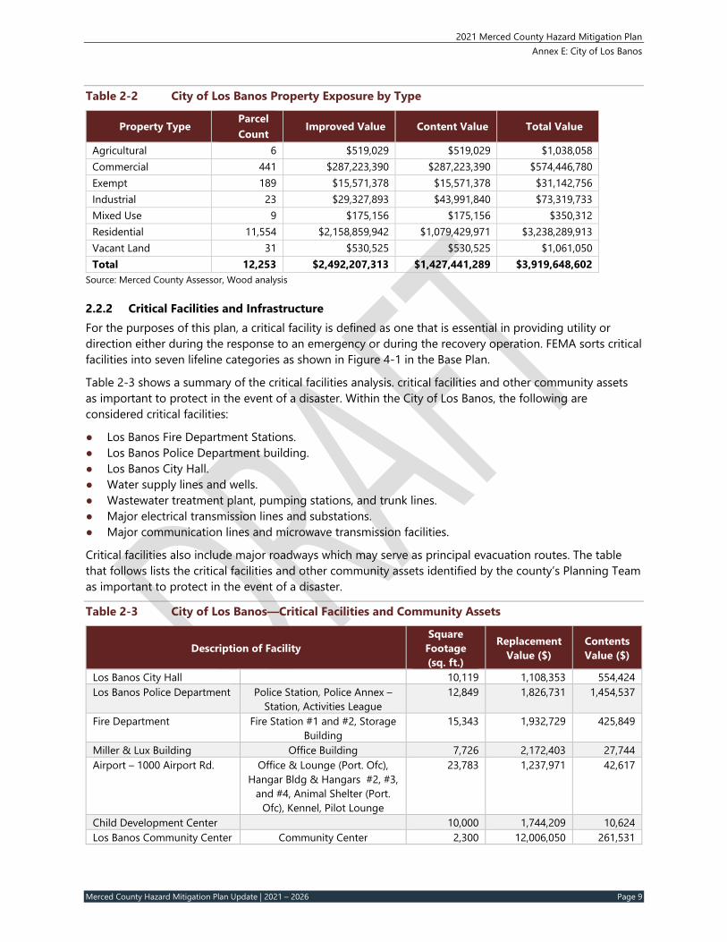
2.2.1 Values at Risk The following data on property exposure is derived from the Merced County 2020 Parcel and Assessor data. This data should only be used as a guideline to overall values in the city as the information has some limitations. The most significant limitation is created by Proposition 13. Instead of adjusting property values annually, the values are not adjusted or assessed at fair market value until a property transfer occurs. As a result, overall value information is likely low and does not reflect current market value of properties. It is also important to note that in the event of a disaster, it is generally the value of the infrastructure or improvements to the land that is of concern or at risk. Generally, the land itself is not a loss and is not included in the values below. Table 2-2 shows the exposure of properties (e.g., the values at risk) broken down by property type for the City of Los Banos.
2021 Merced County Hazard Mitigation Plan Annex E: City of Los Banos
Merced County Hazard Mitigation Plan Update | 2021 – 2026 Page 9
Table 2‐2 City of Los Banos Property Exposure by Type
2.2.2 Critical Facilities and Infrastructure For the purposes of this plan, a critical facility is defined as one that is essential in providing utility or direction either during the response to an emergency or during the recovery operation. FEMA sorts critical facilities into seven lifeline categories as shown in Figure 4-1 in the Base Plan.
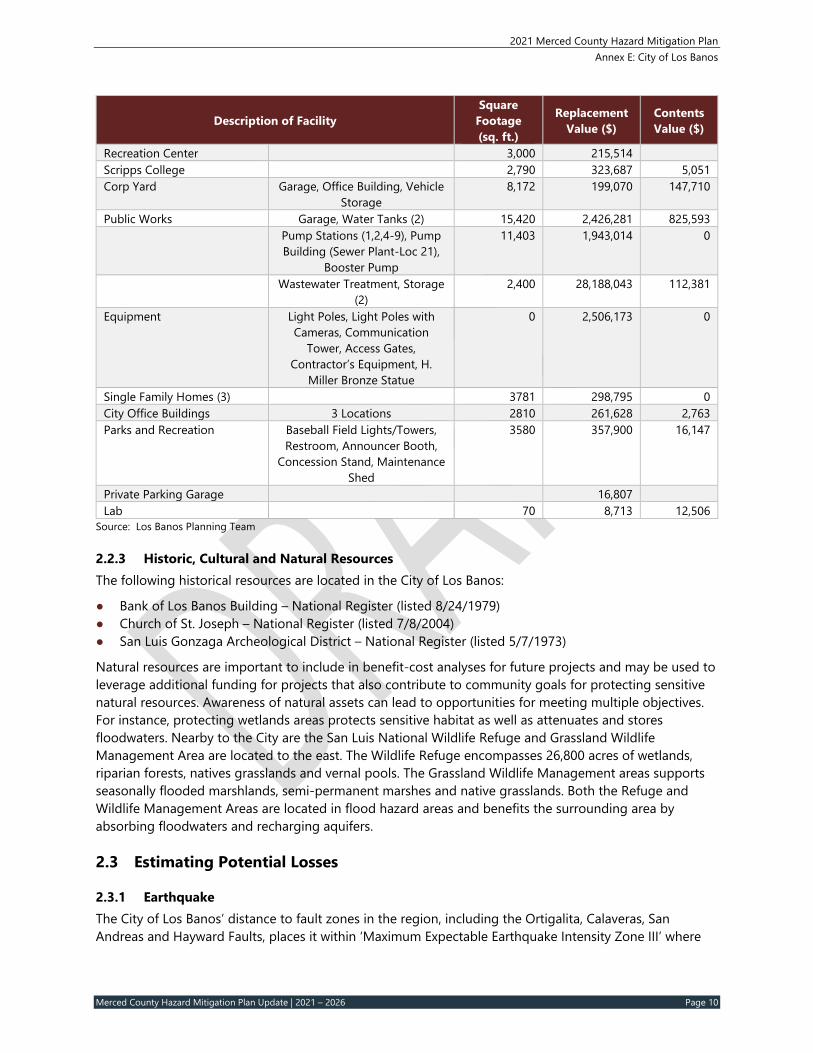
Table 2-3 shows a summary of the critical facilities analysis. critical facilities and other community assets as important to protect in the event of a disaster. Within the City of Los Banos, the following are considered critical facilities:
● Los Banos Fire Department Stations. ● Los Banos Police Department building. ● Los Banos City Hall. ● Water supply lines and wells. ● Wastewater treatment plant, pumping stations, and trunk lines. ● Major electrical transmission lines and substations. ● Major communication lines and microwave transmission facilities.
Critical facilities also include major roadways which may serve as principal evacuation routes. The table that follows lists the critical facilities and other community assets identified by the county’s Planning Team as important to protect in the event of a disaster.
Table 2‐3 City of Los Banos—Critical Facilities and Community Assets
Description of Facility Square
Footage (sq. ft.)
Replacement Value ($)
Contents Value ($)
Los Banos City Hall 10,119 1,108,353 554,424 Los Banos Police Department Police Station, Police Annex –
Station, Activities League 12,849 1,826,731 1,454,537
Fire Department Fire Station #1 and #2, Storage Building
15,343 1,932,729 425,849
Miller & Lux Building Office Building 7,726 2,172,403 27,744 Airport – 1000 Airport Rd. Office & Lounge (Port. Ofc),
2.2.3 Historic, Cultural and Natural Resources The following historical resources are located in the City of Los Banos:
● Bank of Los Banos Building – National Register (listed 8/24/1979) ● Church of St. Joseph – National Register (listed 7/8/2004) ● San Luis Gonzaga Archeological District – National Register (listed 5/7/1973)
Natural resources are important to include in benefit-cost analyses for future projects and may be used to leverage additional funding for projects that also contribute to community goals for protecting sensitive natural resources. Awareness of natural assets can lead to opportunities for meeting multiple objectives. For instance, protecting wetlands areas protects sensitive habitat as well as attenuates and stores floodwaters. Nearby to the City are the San Luis National Wildlife Refuge and Grassland Wildlife Management Area are located to the east. The Wildlife Refuge encompasses 26,800 acres of wetlands, riparian forests, natives grasslands and vernal pools. The Grassland Wildlife Management areas supports seasonally flooded marshlands, semi-permanent marshes and native grasslands. Both the Refuge and Wildlife Management Areas are located in flood hazard areas and benefits the surrounding area by absorbing floodwaters and recharging aquifers.
2.3 Estimating Potential Losses
2.3.1 Earthquake The City of Los Banos’ distance to fault zones in the region, including the Ortigalita, Calaveras, San Andreas and Hayward Faults, places it within ‘Maximum Expectable Earthquake Intensity Zone III’ where
2021 Merced County Hazard Mitigation Plan Annex E: City of Los Banos
Merced County Hazard Mitigation Plan Update | 2021 – 2026 Page 11
‘High Severity, Most Probable Damage’ could result should an earthquake occur in the region. There is no record of any seismic activity originating within the City; however, the Los Banos area has been shaken by earthquakes originating elsewhere. There is documented evidence of six earthquakes that shook the area, those of 1872, 1906, 1952, 1966, 1984, and 1989. Major damage occurred in Los Banos in 1906, with minor damage recorded throughout the county from other occurrences.
No damaging earthquakes greater than M6.0 have been recorded in the City of Los Banos or Merced County in over 200 years, though several have been very close. The most recent large earthquake near Merced County, and the City of Los Banos, was 16 miles east north-east of King City with a magnitude of 5.3 on October 20, 2012. Several aftershocks followed the main earthquake, including a M3.1 aftershock. This quake was preceded by two earthquakes located approximately 100 miles from Merced County, the 1982 New Idria earthquake (M5.4) and the 1983 Coalinga quake (M6.5). There was low level ground shaking and low local magnitude reported.
Based on the earthquake shaking potential mapped for the City of Los Banos, the proximity to the San Andreas Fault and the history of shaking but no surface rupture, the probability of damaging seismic ground shaking in the City of Los Banos is considered as likely. Other hazards associated with earthquake activity, such as lateral spreading, surface cracking, or differential setting, are considered unlikely to occur, although no studies have been conducted to determine the likelihood of these hazards.
2.3.2 Flood and Levee Failure The primary types of flood events in Merced County that may impact the City of Los Banos are riverine and urban. Regardless of the type of flood, the cause is often the result of severe weather and excessive rainfall, either in the flood area, upstream, or from winter snowmelt. Failed dams can create floods that are catastrophic to life and property as a result of the tremendous energy of the released water.
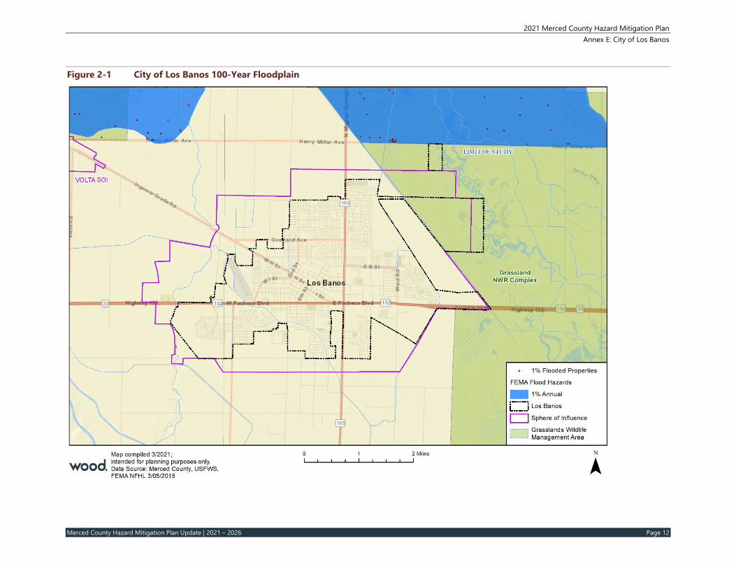
Most of Los Banos lies outside the 100-year floodplain designated by the Federal Emergency Management Agency (FEMA). Several smaller areas in the southeastern portion of the city limits fall short of being in the 100-year floodplain as well as some small areas to the north of the city limits. The City of Los Banos participates in the National Flood Program; however, the FEMA Flood Insurance Study (Number 06047CV000C) reports ‘Merced County includes the Cities of Dos Palos and Los Banos, which do not contain any Special Flood Hazard Areas (SFHAs) and are non-flood prone.’ The following page reflects the flood potential impact areas around the City of Los Banos, with the 100-Year and 200-Year floodplains illustrated in Figure 2-1 and Figure 2-2 respectively. Available history, data, and surveys by FEMA, indicates the City of Los Banos is not in the floodplain and would rarely have the hazard potential for future flooding.
2021 Merced County Hazard Mitigation Plan Annex E: City of Los Banos
Merced County Hazard Mitigation Plan Update | 2021 – 2026 Page 12
Figure 2‐1 City of Los Banos 100‐Year Floodplain
2021 Merced County Hazard Mitigation Plan Annex E: City of Los Banos
Merced County Hazard Mitigation Plan Update | 2021 – 2026 Page 13
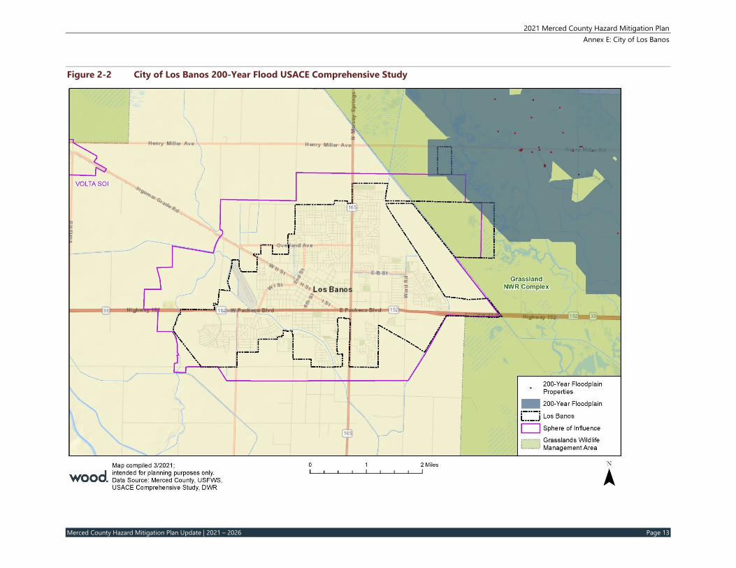
Figure 2‐2 City of Los Banos 200‐Year Flood USACE Comprehensive Study
2021 Merced County Hazard Mitigation Plan Annex E: City of Los Banos
Merced County Hazard Mitigation Plan Update | 2021 – 2026 Page 14
Based on the analysis conducted, the City of Los Banos has no improved parcels located within the 100-year floodplain or 200-year floodplain. No parcels were found to be located within the 500-year floodplain.
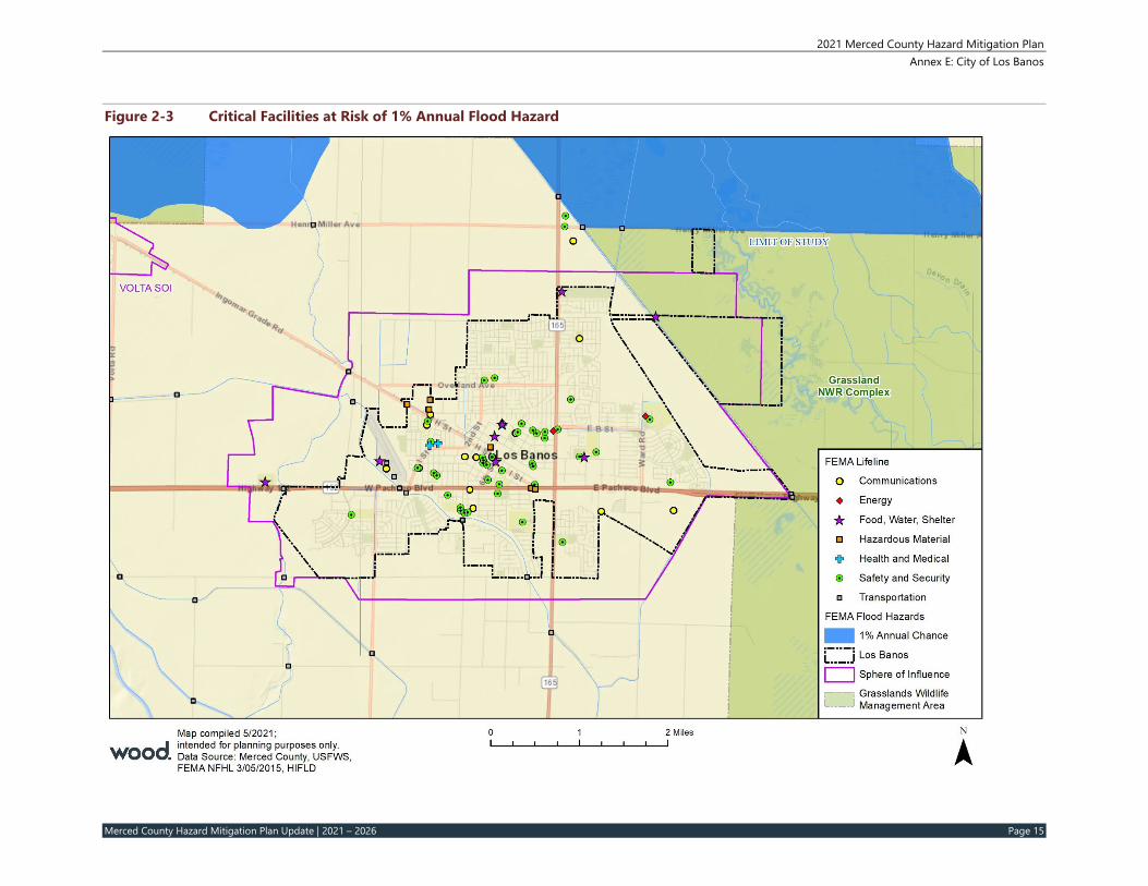
Critical Facilities at Risk Critical facilities are those community components that are most needed to withstand the impacts of disaster as previously described. There are no critical facilities located within the City of Los Banos which are also in the floodplain, although there are some within the general vicinity of Los Banos which are exposed to flood hazards as shown in Figure 2-3. The impact to the wider community could be great if these facilities are damaged or destroyed during a flood event.
2021 Merced County Hazard Mitigation Plan Annex E: City of Los Banos
Merced County Hazard Mitigation Plan Update | 2021 – 2026 Page 15
Figure 2‐3 Critical Facilities at Risk of 1% Annual Flood Hazard
2021 Merced County Hazard Mitigation Plan Annex E: City of Los Banos
Merced County Hazard Mitigation Plan Update | 2021 – 2026 Page 16
Insurance Coverage, Claims Paid, and Repetitive Losses The City of Los Banos joined the National Flood Insurance Program (NFIP) on February 3, 1998. NFIP Insurance data indicates that as of July 2021, there were 16 flood insurance policies in force in the City with $5,180,000 of coverage. All of the policies are single family residential and located in the B, C, and X zone.
There has been no historical claims for flood losses in Los Banos. According to the FEMA Community Information System accessed July 23, 2021, the City has no Repetitive Loss properties or Severe Repetitive Loss properties.
2.3.3 Wildfires Weather components, such as temperature, relative humidity, wind, and lightning, also affect the potential for wildfire. High temperatures and low relative humidity dry out the fuels that feed the wildfire creating a situation where fuel will more readily ignite and burn more intensely. Both urban and wildland fire conditions exist in Merced County and its cities which increases the chances for damage to property, loss of life and/or injury. In most of Merced County, the California Department of Forestry and Fire Protection (Cal Fire) ranks fuel loading as low. Fuels are mainly crops and grasses. In the southwest corner, there are some brush, pine, and grass fuels, which are ranked as moderate fuel hazards, primarily in the area west of Interstate 5.
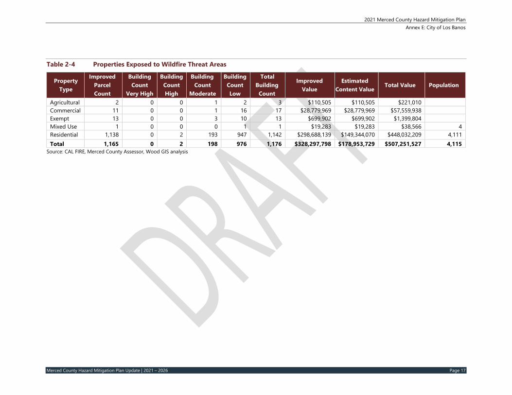
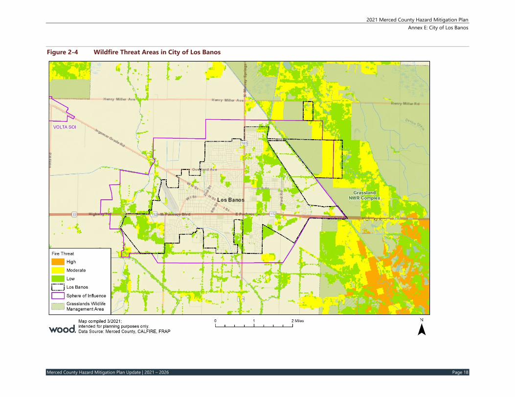
There have not been any state or federal disaster declarations in the City of Los Banos or Merced County related to wildfire in the past. The Planning Team noted that although there are many fire starts, the fuels are “flashy” and fires are usually quickly put out. Table 2-13 below summarizes the counts, values, and property types of improved parcels exposed to various wildfire hazards, as well as an estimated exposed population. Figure 2-5 shows the wildfire threat areas in Los Banos.
2021 Merced County Hazard Mitigation Plan Annex E: City of Los Banos
Merced County Hazard Mitigation Plan Update | 2021 – 2026 Page 17
Table 2‐4 Properties Exposed to Wildfire Threat Areas
Source: CAL FIRE, Merced County Assessor, Wood GIS analysis
2021 Merced County Hazard Mitigation Plan Annex E: City of Los Banos
Merced County Hazard Mitigation Plan Update | 2021 – 2026 Page 18
Figure 2‐4 Wildfire Threat Areas in City of Los Banos
2021 Merced County Hazard Mitigation Plan Annex E: City of Los Banos
Merced County Hazard Mitigation Plan Update | 2021 – 2026 Page 19
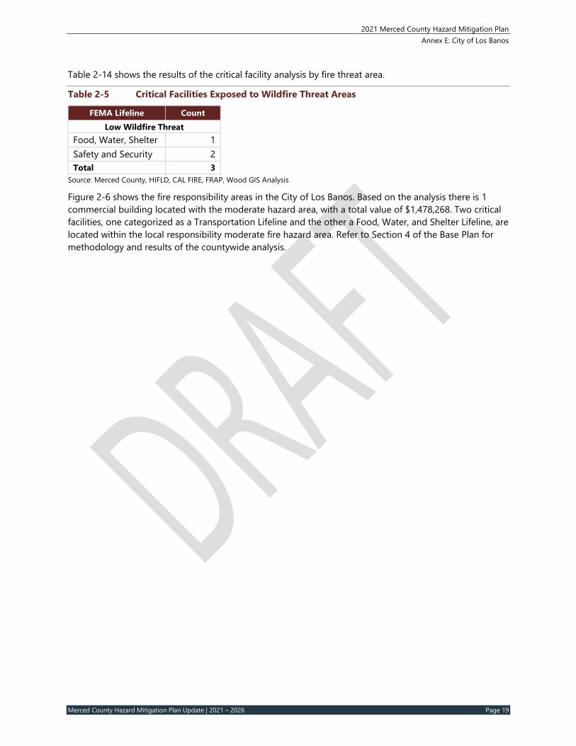
Table 2-14 shows the results of the critical facility analysis by fire threat area.
Table 2‐5 Critical Facilities Exposed to Wildfire Threat Areas
FEMA Lifeline Count Low Wildfire Threat
Food, Water, Shelter 1 Safety and Security 2 Total 3
Source: Merced County, HIFLD, CAL FIRE, FRAP, Wood GIS Analysis
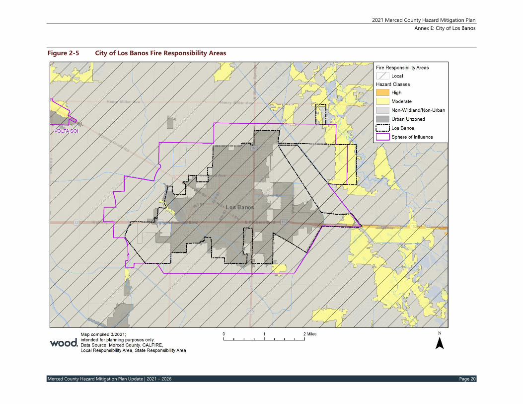
Figure 2-6 shows the fire responsibility areas in the City of Los Banos. Based on the analysis there is 1 commercial building located with the moderate hazard area, with a total value of $1,478,268. Two critical facilities, one categorized as a Transportation Lifeline and the other a Food, Water, and Shelter Lifeline, are located within the local responsibility moderate fire hazard area. Refer to Section 4 of the Base Plan for methodology and results of the countywide analysis.
2021 Merced County Hazard Mitigation Plan Annex E: City of Los Banos
Merced County Hazard Mitigation Plan Update | 2021 – 2026 Page 20
Figure 2‐5 City of Los Banos Fire Responsibility Areas
2021 Merced County Hazard Mitigation Plan Annex E: City of Los Banos
Merced County Hazard Mitigation Plan Update | 2021 – 2026 Page 21
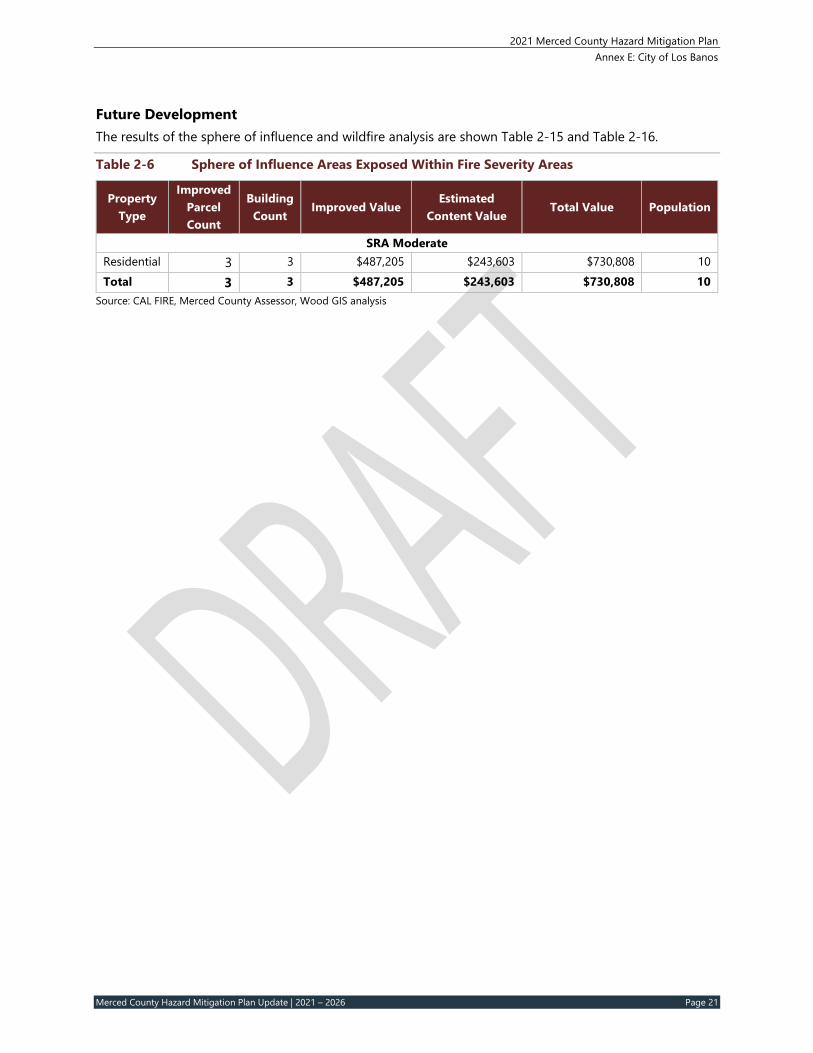
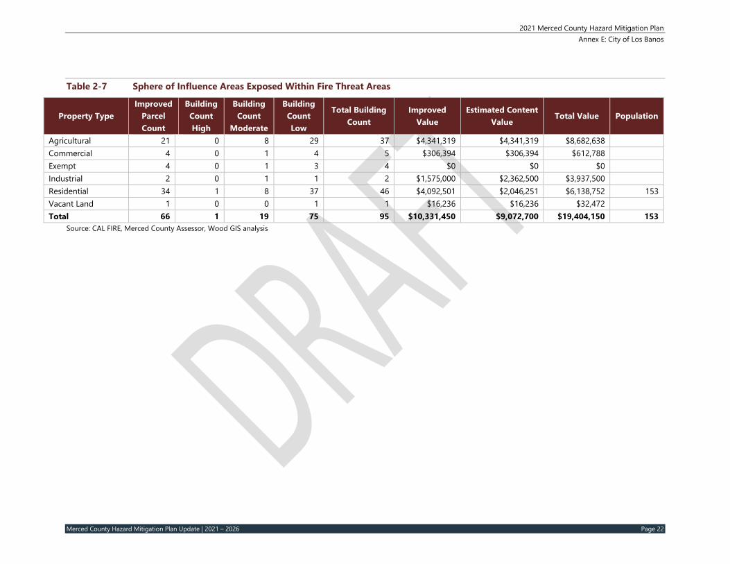
Future Development The results of the sphere of influence and wildfire analysis are shown Table 2-15 and Table 2-16.
Table 2‐6 Sphere of Influence Areas Exposed Within Fire Severity Areas
Source: CAL FIRE, Merced County Assessor, Wood GIS analysis
2021 Merced County Hazard Mitigation Plan Annex E: City of Los Banos
Merced County Hazard Mitigation Plan Update | 2021 – 2026 Page 23
3 CAPABILITY ASSESSMENT
Capabilities are the programs and policies currently in use to reduce hazard impacts or that could be used to implement hazard mitigation activities. This capabilities assessment is divided into five sections: regulatory mitigation capabilities, administrative and technical mitigation capabilities, fiscal mitigation capabilities, mitigation outreach and partnerships, and other mitigation efforts. To develop this capability assessment, the jurisdictional planning representatives reviewed a matrix of common mitigation activities to inventory which of these policies or programs and shared any updates or changes through the Los Banos Data Collection Guide. The team then supplemented this inventory by reviewing additional existing policies, regulations, plans, and programs to determine if they contribute to reducing hazard-related losses.
During the plan update process, this inventory was reviewed by the jurisdictional planning representatives and Wood consultant team staff to update information where applicable and note ways in which these capabilities have improved or expanded. Additionally, in summarizing current capabilities and identifying gaps, the jurisdictional planning representatives also considered their ability to expand or improve upon existing policies and programs as potential new mitigation strategies. The City of Los Banos’ capabilities are summarized below.
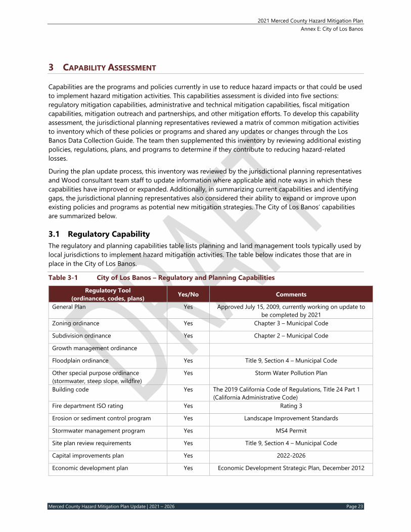
3.1 Regulatory Capability The regulatory and planning capabilities table lists planning and land management tools typically used by local jurisdictions to implement hazard mitigation activities. The table below indicates those that are in place in the City of Los Banos.
Table 3‐1 City of Los Banos – Regulatory and Planning Capabilities
City of Los Banos General Plan, 2009 – The City of Los Banos approved its General Plan revision in July 2009, with an anticipated horizon year of 2030. This General Plan defines the City’s goals, objectives and policies that guide the physical growth, use and development of land under the jurisdictional authority of the City.
The purpose of the Public Health and Safety Element is to reduce or eliminate long term risk to people and property from natural or human caused hazards. This element focuses on establishing policies and programs to protect the community from risks associated with seismic, geologic, flood, and fire hazards. The Public Health and Safety Element is now expanded to include community health and community safety related issues that are more commonly associated with the built environment as affecting the health and safety of residents living within the City. As noted above, the city is currently in the process of updating the General Plan through the year 2040.
City of Los Banos Emergency Plan, 2015 – The Emergency Plan addresses the planned response to emergency situations associated with natural disasters, technological incidents, human caused events and national security emergencies in or affecting the City of Los Banos. The plan establishes the emergency management organization required to mitigate any significant emergency or disaster affecting the City; identifies the policies, responsibilities, and procedures required to protect the health and safety of communities, public and private property, and the environmental effects of natural, human caused and technological emergencies and disasters; and establishes the operational concepts and policies for disaster response and recovery.
City Fire Management Plan – The City of Los Banos Fire Department is a full-service department providing fire protection, fire suppression, inspections, public education, fire responders for medical aids, and all types of technical rescue operations. The department operates four (4) front line engines, one reserve engine, one OES engine, one ladder truck, two rescue units, water tender, and other service vehicles. The goals of the Los Banos Fire Department and Volunteer Fire Department are:
● To continue to provide cost effective fire protection and emergency services to the citizens of Los Banos;
● To improve operational efficiency and accountability, to continue moving in a positive direction providing the best possible service to the community;
● To continue to foster the Volunteer Fire Department providing training, comradery and pride in their department; and
● To support the goals, objectives and mission of the City of Los Banos.
The primary mission of the Los Banos Fire Department and Volunteer Fire Department is to protect life and property for the citizens of the City of Los Banos from the effect of fires, medical emergencies, vehicle accidents, exposure to hazardous materials, earthquakes, floods, disasters and dangerous conditions. The life safety and property protection mission is accomplished through a wide range of programs which
2021 Merced County Hazard Mitigation Plan Annex E: City of Los Banos
Merced County Hazard Mitigation Plan Update | 2021 – 2026 Page 25
include fire protection, fire prevention, planning, fire prevention education, fire inspections, code enforcement, fire suppression, and training. The Los Banos Fire Department also provides mutual aid for fire/rescue and EMS services to other local agencies in Merced County, and participates in the statewide Master Mutual Aid plan.
Emergency Services Ordinance, Title 4, Chapter 2 – The declared purposes of this chapter are to provide for the preparation and carrying out of plans for the protection of persons and property within the City in the event of an emergency; the direction of the emergency organization; and the coordination of the emergency functions of the City with all other public agencies, corporations, organizations and affected private persons. The council’s powers include the development of emergency and mutual aid plans and agreements and the ordinances and resolutions as necessary to implement the Multi-Hazard Functional Plan and any other such plans and agreements.
California Fire Code – Title 4, Chapter 3 – For the purpose of prescribing regulations governing conditions hazardous to life and property from fire, hazardous materials or explosion, that certain Code known as the 2013 California Fire Code (Part 9 of Title 24 of the California Code of Regulations), as published by the International Code Council, together with all appendices and subsequent additions and editions thereto, one copy of which is on file in the office of the City Clerk for public record and inspection, is hereby adopted by reference and made a part of this chapter as though set forth in this chapter in full, subject, however, to the amendments, additions, and deletions set forth in this chapter, and said Code shall be known as the Fire Prevention Code of the City of Los Banos. (§ 1, Ord. 1066, eff. February 1, 2008, as amended by § 1, Ord. 1099, eff. August 20, 2011, and § 1, Ord. 1117, eff. March 19, 2014)
Floodplain Management Ordinance Chapter 9‐Sec.4‐9.12 – It is the purpose of this chapter to promote the public health, safety, and general welfare, and to minimize public and private losses due to flood conditions in specific areas by provisions designed to:
● Protect human life and health; ● Minimize expenditure of public money for costly flood control projects; ● Minimize the need for rescue and relief efforts associated with flooding and generally undertaken at
the expense of the general public; ● Minimize prolonged business interruptions; ● Minimize damage to public facilities and utilities such as water and gas mains; electric, telephone and
sewer lines; and streets and bridges located in areas of special flood hazard; ● Help maintain a stable tax base by providing for the sound use and development of areas of special
flood hazard so as to minimize future blighted areas caused by flood damage; ● Ensure that potential buyers are notified that property is in an area of special flood hazard; and, ● Ensure that those who occupy the areas of special flood hazard assume responsibility for their actions.
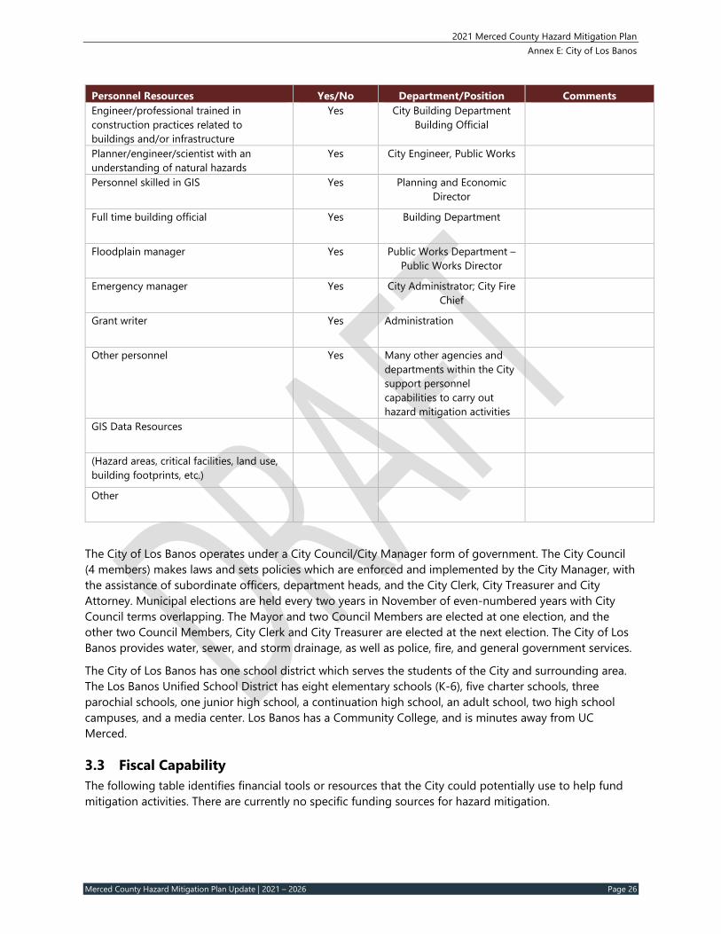
3.2 Administrative and Technical Capability The table below identifies city personnel with responsibilities for activities related to mitigation and loss prevention in the City of Los Banos. Many positions are full time and/or filled by the same person. A summary of technical resources follows.
Table 3‐2 City of Los Banos – Personnel Capabilities
Personnel Resources Yes/No Department/Position Comments Planner/engineer with knowledge of land development/land management practices
Yes Planning and Economic Development Director
2021 Merced County Hazard Mitigation Plan Annex E: City of Los Banos
Merced County Hazard Mitigation Plan Update | 2021 – 2026 Page 26
Personnel Resources Yes/No Department/Position Comments Engineer/professional trained in construction practices related to buildings and/or infrastructure
Yes City Building Department Building Official
Planner/engineer/scientist with an understanding of natural hazards
Yes City Engineer, Public Works
Personnel skilled in GIS Yes Planning and Economic Director
Full time building official Yes Building Department
Floodplain manager Yes Public Works Department – Public Works Director
Emergency manager Yes City Administrator; City Fire Chief
Grant writer Yes Administration
Other personnel Yes Many other agencies and departments within the City support personnel capabilities to carry out hazard mitigation activities
GIS Data Resources
(Hazard areas, critical facilities, land use, building footprints, etc.)
Other
The City of Los Banos operates under a City Council/City Manager form of government. The City Council (4 members) makes laws and sets policies which are enforced and implemented by the City Manager, with the assistance of subordinate officers, department heads, and the City Clerk, City Treasurer and City Attorney. Municipal elections are held every two years in November of even-numbered years with City Council terms overlapping. The Mayor and two Council Members are elected at one election, and the other two Council Members, City Clerk and City Treasurer are elected at the next election. The City of Los Banos provides water, sewer, and storm drainage, as well as police, fire, and general government services.
The City of Los Banos has one school district which serves the students of the City and surrounding area. The Los Banos Unified School District has eight elementary schools (K-6), five charter schools, three parochial schools, one junior high school, a continuation high school, an adult school, two high school campuses, and a media center. Los Banos has a Community College, and is minutes away from UC Merced.
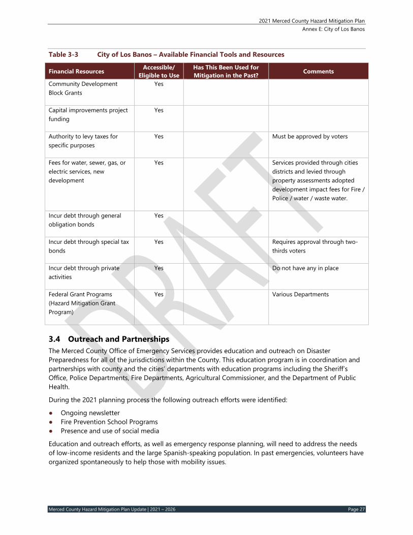
3.3 Fiscal Capability The following table identifies financial tools or resources that the City could potentially use to help fund mitigation activities. There are currently no specific funding sources for hazard mitigation.
2021 Merced County Hazard Mitigation Plan Annex E: City of Los Banos
Merced County Hazard Mitigation Plan Update | 2021 – 2026 Page 27
Table 3‐3 City of Los Banos – Available Financial Tools and Resources
Financial Resources Accessible/ Eligible to Use
Has This Been Used for Mitigation in the Past? Comments
Community Development Block Grants
Yes
Capital improvements project funding
Yes
Authority to levy taxes for specific purposes
Yes Must be approved by voters
Fees for water, sewer, gas, or electric services, new development
Yes Services provided through cities districts and levied through property assessments adopted development impact fees for Fire / Police / water / waste water.
Incur debt through general obligation bonds
Yes
Incur debt through special tax bonds
Yes Requires approval through two-thirds voters
Incur debt through private activities
Yes Do not have any in place
Federal Grant Programs (Hazard Mitigation Grant Program)
Yes Various Departments
3.4 Outreach and Partnerships The Merced County Office of Emergency Services provides education and outreach on Disaster Preparedness for all of the jurisdictions within the County. This education program is in coordination and partnerships with county and the cities’ departments with education programs including the Sheriff’s Office, Police Departments, Fire Departments, Agricultural Commissioner, and the Department of Public Health.
During the 2021 planning process the following outreach efforts were identified:
● Ongoing newsletter ● Fire Prevention School Programs ● Presence and use of social media
Education and outreach efforts, as well as emergency response planning, will need to address the needs of low-income residents and the large Spanish-speaking population. In past emergencies, volunteers have organized spontaneously to help those with mobility issues.
2021 Merced County Hazard Mitigation Plan Annex E: City of Los Banos
Merced County Hazard Mitigation Plan Update | 2021 – 2026 Page 28
3.4.1 Planning Commission The Planning Commission performs the duties described in the present or any future zoning ordinances and subdivision regulations of the City’s Municipal Code. This includes any similar ordinance, statute, rule or regulation of the State, County or this City pertaining to the districting, zoning or dividing the city into districts or zones and regulating the construction of improvements, the use, division or minor subdivision of property within the City. The City Council provides the Planning Commission with its directions and assigns tasks. The Planning Commission is charged with the responsibility of studying the needs of the City in which they advise and recommend to the City Council concerning the establishment, modifications and change of zones or districts, and designations of the uses to which property contained therein may be prohibited, restricted, and regulated and other duties as may be delegated by the City Council.
3.4.2 The Economic Development Advisory Committee The Los Banos Economic Development Advisory Commission (EDAC) was formed to assist the City of Los Banos in an advisory capacity. Cities throughout the State of California have Economic Development Advisory Commissions that meet monthly and provide ideas and support for economic projects within each jurisdiction’s redevelopment area.
3.4.3 Traffic Safety Committee The City of Los Banos has established a Traffic Safety Committee as outlined in Los Banos Municipal Code Section 4-5.05. It was established in 1992. Members include representatives from the Public Works Department, Community & Economic Development Department, Police Department, Fire Department, and Planning Commission. This Committee has the duty of initiating or reviewing all proposals or requests for establishment, modification, elimination, or removal of all traffic control signs, signals, markings, speed zones, prohibited or restricted parking zones, or other such related matters, which fall under the lawful discretionary control of the City.
3.5 Other Mitigation Efforts In addition to the project identified in the City’s Mitigation Action plan, the City of Los Banos’ Fire Department conducts annual fire and life safety inspections for all businesses and SB 1205 occupancies (Apartments, Hotels, Assemblies and Schools). The Los Banos Fire Department also provides mutual aid for fire/rescue and EMS services to other local agencies in Merced County, and participates in the statewide Master Mutual Aid plan.
3.6 Opportunities for Enhancement Based on the capabilities assessment, the City of Los Banos has several existing mechanisms in place that already help to mitigate hazards. There are also opportunities for the city to expand or improve on their policies, programs and fiscal capabilities and further protect the community. Future improvements may include providing training for staff members related to hazards or hazard mitigation grant funding in partnership with the County and Cal OES. Additional training opportunities will help to inform City staff members on how best to integrate hazard information and mitigation projects into their departments. Continuing to train City staff on mitigation and the hazards that pose a risk to the City of Los Banos will lead to more informed staff members who can better communicate this information to the public. The City is also enhancing their residential inspection program that identifies unreinforced masonry (URM) buildings in the downtown area. These annual inspections help the City identify and mitigate seismic risk associated with this construction method of construction.
2021 Merced County Hazard Mitigation Plan Annex E: City of Los Banos
Merced County Hazard Mitigation Plan Update | 2021 – 2026 Page 29
4 MITIGATION STRATEGY
4.1 Goals and Objectives The City of Los Banos adopts the hazard mitigation goals and objectives developed by the Planning Team and described in Section 5 Mitigation Strategy of the Basin Plan.
4.2 Continued Compliance with the National Flood Insurance Program The city has been an NFIP participating community since 1998. In addition to the mitigation actions identified herein the City will continue to comply with the NFIP. Floodplain management is under the purview of the Director of the Public Works Department. This includes ongoing activities such as enforcing local floodplain development regulations, including issuing permits for appropriate development in Special Flood Hazard Areas and ensuring that this development mitigated in accordance with the regulations. This will also include periodic reviews of the floodplain ordinance to ensure that it is clear and up to date and reflects new or revised flood hazard mapping.
4.3 Progress on 2014 Actions During the 2021 planning process the City of Los Banos Planning Team reviewed all the mitigation actions from the 2014 plan. Of their ten (10) mitigation actions from 2014, eight (8) of the actions are continuing and are implemented annually, demonstrating ongoing progress and building the community’s resiliency to disasters. Two (2) actions were deleted that were more county-focused. Seven (7) new actions were added in 2021.
4.4 Mitigation Actions The Planning Team for the City identified and prioritized the following mitigation actions based on risk assessments, goals, and objectives. Background information as well as information on how the action will be implemented and administered, such as ideas for implementation, responsible office, partners, potential funding, estimated cost, and timeline also are described.
2021 Merced County Hazard Mitigation Plan Annex E: City of Los Banos
Merced County Hazard Mitigation Plan Update | 2021 – 2026 Page 30
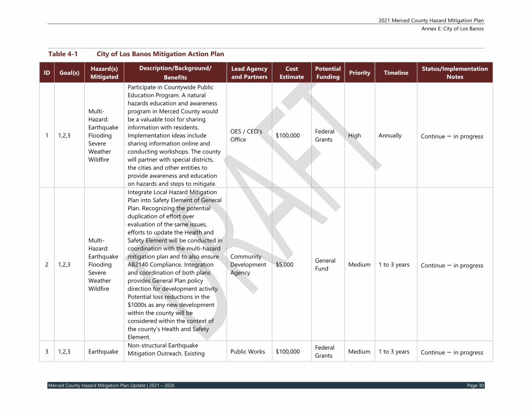
Table 4‐1 City of Los Banos Mitigation Action Plan
Multi-Hazard: Earthquake Flooding Severe Weather Wildfire
Participate in Countywide Public Education Program. A natural hazards education and awareness program in Merced County would be a valuable tool for sharing information with residents. Implementation ideas include sharing information online and conducting workshops. The county will partner with special districts, the cities and other entities to provide awareness and education on hazards and steps to mitigate.
OES / CEO's Office $100,000 Federal
Grants High Annually Continue – in progress
2 1,2,3
Multi-Hazard: Earthquake Flooding Severe Weather Wildfire
Integrate Local Hazard Mitigation Plan into Safety Element of General Plan. Recognizing the potential duplication of effort over evaluation of the same issues, efforts to update the Health and Safety Element will be conducted in coordination with the multi-hazard mitigation plan and to also ensure AB2140 Compliance. Integration and coordination of both plans provides General Plan policy direction for development activity. Potential loss reductions in the $1000s as any new development within the county will be considered within the context of the county’s Health and Safety Element.
Community Development Agency
$5,000 General Fund Medium 1 to 3 years Continue – in progress
3 1,2,3 Earthquake Non-structural Earthquake Mitigation Outreach. Existing Public Works $100,000 Federal
Grants Medium 1 to 3 years Continue – in progress
2021 Merced County Hazard Mitigation Plan Annex E: City of Los Banos
Merced County Hazard Mitigation Plan Update | 2021 – 2026 Page 31
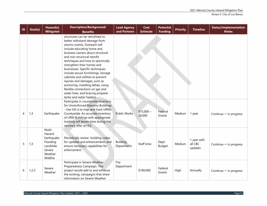
Notes structures can be retrofitted to better withstand damage from seismic events. Outreach will include educating home and business owners about structural and non-structural retrofit techniques and how to seismically strengthen their homes and businesses. Specific techniques include secure furnishings, storage cabinets and utilities to prevent injuries and damages, such as anchoring, installing lathes, using flexible connections on gas and water lines, and bracing propane tanks and water heaters.
4 1,3 Earthquake
Participate in countywide Inventory for Unreinforced Masonry Buildings - Use GIS a to map and track URMs Countywide. An accurate inventory of URM Buildings with appropriate tracking will lessen time during the recovery after an EQ.
Public Works $15,000 – 20,000
Federal Grants Medium 1 year Continue – in progress
5 1,3
Multi-Hazard: Earthquake Flooding Landslide Severe Weather Wildfire
Periodically review building codes for updates and enhancements and ensure necessary capabilities for enforcement.
Building Department Staff time Dept.
Budget Medium 1 year with all CBC updates
Continue – in progress
6 1,2,3 Severe Weather
Participate in Severe Weather Preparedness Campaign. This project would add to and enhance the existing, campaigns that share information on Severe Weather
Fire Department
$100,000 Federal Grants High Annually Continue – in progress
2021 Merced County Hazard Mitigation Plan Annex E: City of Los Banos
Merced County Hazard Mitigation Plan Update | 2021 – 2026 Page 32
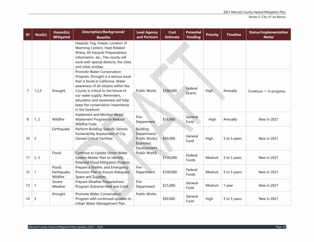
Notes Hazards: Fog, Freeze, Location of Warming Centers, Heat Related Illness, All Hazards Preparedness information, etc.; The county will work with special districts, the cities and other entities.
7 1,2,3 Drought
Promote Water Conservation Program. Drought is a serious issue that is faced in California. Water awareness of all citizens within the County is critical to the future of our water supply. Reminders, education and awareness will help keep the conservation importance in the forefront.
Public Works $100,000 Federal Grants High Annually Continue – in progress
8 1, 2 Wildfire Implement and Monitor Weed Abatement Program to Reduce Wildfire Fuels
Fire Department $15,000 General
Fund High Annually New in 2021
10 3
Earthquake Perform Building-Specific Seismic Vulnerability Assessment of City Owned Critical Facilities
Building Department/ Public Works/ Economic Development
$50,000 General Fund High 3 to 5 years New in 2021
11 2, 3 Flood Continue to Update Storm Water
System Master Plan to Identify Potential Flood Mitigation Projects
Public Work$ $100,000 Federal
Funds Medium 3 to 5 years New in 2021
12 1 Flood, Earthquake, Wildfire
Prepare a Shelter, and Emergency Provision Plan to Ensure Adequate Space and Supplies
Fire Department $100,000 Federal
Funds Medium 3 to 5 years New in 2021
13 1 Severe Weather
Prepare Weather Preparedness Program (Extreme Heat and Cold)
Fire Department $25,000 General
Fund Medium 1 year New in 2021
14 3 Drought Promote Water Conservation
Program with continued updates to Urban Water Management Plan
Public Works $50,000 General
Fund High 3 to 5 years New in 2021
2021 Merced County Hazard Mitigation Plan Annex E: City of Los Banos
Merced County Hazard Mitigation Plan Update | 2021 – 2026 Page 33
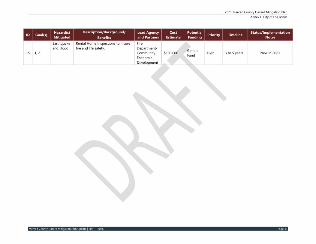
Rental Home Inspections to insure fire and life safety.
Fire Department/Community Economic Development
$100,000 General Fund High 3 to 5 years New in 2021
2021 Merced County Hazard Mitigation Plan Annex E: City of Los Banos
Merced County Hazard Mitigation Plan Update | 2021 – 2026 Page 34
5 IMPLEMENTATION AND MAINTENANCE
Moving forward, the city will use the mitigation action table in the previous section to track progress on implementation of each project. Implementation of the plan overall is discussed in Section 6 in the Base Plan.
5.1 Incorporation into Existing Planning Mechanisms The information contained within this plan, including results from the Vulnerability Assessment, and the Mitigation Strategy will be used by the City to help inform updates and the development of local plans, programs and policies. The Engineering Division may utilize the hazard information when implementing the City’s Community Investment Program and the Planning and Economic Department s may utilize the hazard information when reviewing a site plan or other type of development applications. The City’s Public Works Department would integrate key flood and stormwater projects outlined in the MJHMP in the most recent Capital Improvement Program. The City is also currently undergoing a General Plan update; during this planning process they City’s Planning and Economic Development Department will incorporate this MJHMP into the Safety Element of their General Plan, as recommended by Assembly Bill (AB) 2140.
As noted in Section 6 of the Base Plan, the HMPT representatives from Los Banos will report on efforts to integrate the hazard mitigation plan into local plans, programs and policies and will report on these efforts at the annual HMPT plan review meeting.
5.2 Monitoring, Evaluation and Updating the Plan The City will follow the procedures to monitor, review, and update this plan in accordance with Merced County as outlined in Section 6 of the Base Plan. The city will continue to involve the public in mitigation, as described in Section 6.2.1 of the Base Plan. The Los Banos Fire Department, Fire Chief will be responsible for representing the city in the County HMPT, and for coordination with City staff and departments during plan updates. The City realizes it is important to review the plan regularly and update it every five years in accordance with the Disaster Mitigation Act Requirements as well as other State of California requirements.