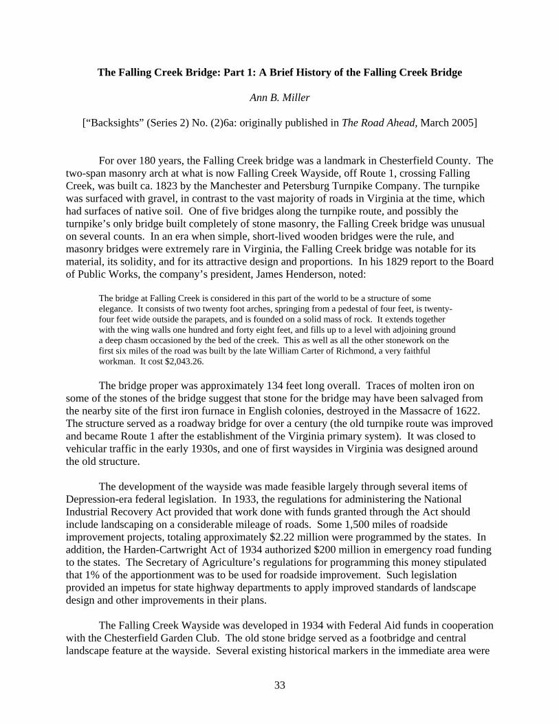
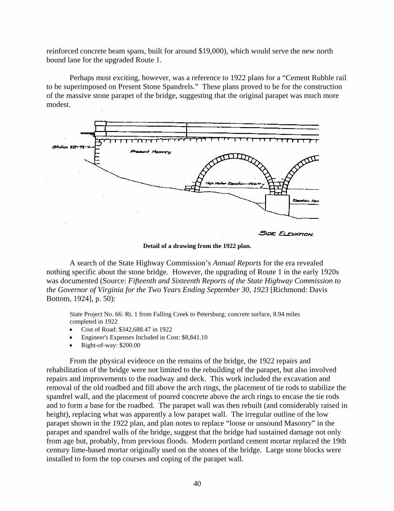
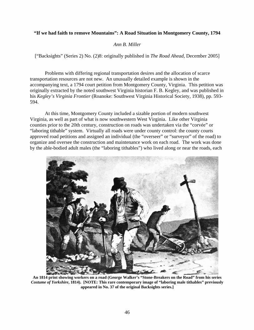
“Backsights” Essays in Virginia Transportation History Volume Two: Reprints of Series Two(2000-2007) Virginia Center for Transportation Innovation & Research Ann B. Miller Senior Research Scientist http://www.virginiadot.org/vtrc/main/online_reports/pdf/11-r19.pdf
Transcript
“Backsights”
Essays in Virginia Transportation History
Volume Two: Reprints of Series Two(2000-2007)
Virginia Center for Transportation Innovation & Research
10. Work Unit No. (TRAIS): 11. Contract or Grant No.:
9. Performing Organization and Address: Virginia Center for Transportation Innovation and Research 530 Edgemont Road Charlottesville, VA 22903
81088
12. Sponsoring Agencies’ Name and Address: 13. Type of Report and Period Covered: Final 14. Sponsoring Agency Code:
Virginia Department of Transportation 1401 E. Broad Street Richmond, VA 23219
Federal Highway Administration 400 North 8th Street, Room 750 Richmond, VA 23219-4825
15. Supplementary Notes: 16. Abstract: This is the second of two volumes of a project to compile, convert to electronic format, and index the “Backsights” series of essays on Virginia transportation history. Between 1972 and 2007, these essays, by various authors, periodically appeared in various publications of the Virginia Department of Transportation, originally in the Bulletin and subsequently in the newsletter of the Virginia Transportation Technology Transfer Center. The essays are presented in two volumes: Volume I, the previous volume, includes all the articles in the initial series (1972-1985); Volume II, the current volume, includes all the articles in the second series (2000 to 2007). These articles cover a wide range of subject matter, from topics specific to Virginia transportation through the years to articles that place Virginia transportation in a national and international context. The topics are as diverse as short biographies of pioneering road and bridge builders; major early highways in Virginia; the role of women in 18th and 19th century transportation; early road and bridge specifications and building practices; the growth of railroads; the evolution of public transportation in Virginia; the varying experiences of travelers throughout Virginia’s history; the rise of the automobile age; the history of taverns in Virginia; and transportation-related historic preservation and cultural resource issues. Although the majority of these articles are long out of print, copies have been regularly requested and utilized by historical and cultural resource researchers, as well as by members of the general public. The requests for specific articles, as well as for information on early roads, turnpikes, canals, etc., have demonstrated the need for this compilation.
These volumes will provide direct electronic access to all of the “Backsights” essays from the inception of the series in 1972 through 2007, along with a comprehensive index for each volume. These essays are utilized by VDOT environmental and cultural resource personnel, as well as by transportation historians, academic and professional historical and cultural resource researchers, and interested members of the public.
17 Key Words: 18. Distribution Statement: Transportation history, cultural resources No restrictions. This document is available to the public
through NTIS, Springfield, VA 22161. 19. Security Classif. (of this report): 20. Security Classif. (of this page): 21. No. of Pages: 22. Price: Unclassified Unclassified 79
Form DOT F 1700.7 (8-72) Reproduction of completed page authorized
FINAL REPORT
“BACKSIGHTS”: ESSAYS IN VIRGINIA TRANSPORTATION HISTORY: VOLUME II: REPRINTS OF SERIES 2 (2000-2007)
Ann B. Miller Senior Research Scientist
In Cooperation with the U.S. Department of Transportation Federal Highway Administration
Virginia Center for Transportation Innovation and Research (A partnership of the Virginia Department of Transportation
and the University of Virginia since 1948)
Charlottesville, Virginia
June 2011 VCTIR 11-R19
ii
DISCLAIMER
The contents of this report reflect the views of the author, who is responsible for the facts and the accuracy of the data presented herein. The contents do not necessarily reflect the official views or policies of the Virginia Department of Transportation, the Commonwealth Transportation Board, or the Federal Highway Administration. This report does not constitute a standard, specification, or regulation. Any inclusion of manufacturer names, trade names, or trademarks is for identification purposes only and is not to be considered an endorsement.
Copyright 2011 by the Commonwealth of Virginia. All rights reserved.
iii
The general utility of artificial roads and canals is at this time so universally admitted, as hardly to require any additional proofs. It is sufficiently evident that, whenever the annual expense of transportation on a certain route, in its natural state, exceeds the interest on the capital employed in improving the communication, and the annual expense of transportation (exclusively of the tolls) by the improved route, the difference is an annual additional income to the nation.
—Albert Gallatin, Report on Internal Improvements, 1808
Dec. 12th, Wednesday. Hard frost. Left Fredericksburg at nine, A.M. Reached Stafford, C. H., at half-past eleven, Dumfries at five minutes past three, P.M., and Occoguon at half-past five. I made no stop except to breathe the horses, from Dumfries to Neabsco, sixty-five minutes three and a half miles. The five miles beyond Dumfries employed nearly two hours. Roads indescribable.
—John Randolph of Roanoke, 1821 The measures necessary to be taken for affording the means of travelling with rapidity and safety, and of transporting goods at low rates of carriage, form an essential part of the domestic economy of every people. The making of roads, in point of fact, is fundamentally essential to bring about the first change that every rude country must undergo in emerging from a condition of poverty and barbarism. It is, therefore, one of the most important duties of every government to take care that such laws be enacted, and such means provided, as are requisite for the making and maintaining of well-constructed roads into and throughout every portion of the territory under its authority.
—Sir Henry Parnell, A Treatise of Roads, 1833
iv
v
ABOUT THE AUTHORS OF “BACKSIGHTS” (SERIES 2: 2000-2007)
Ann B. Miller received her bachelor’s and master’s degrees in architectural history from
the University of Virginia. She joined the staff of the Virginia Transportation Research Council (now the Virginia Center for Transportation Innovation and Research, VCTIR) in 1992, after previously being involved with a number of student projects and cooperative projects between the Research Council and various historical organizations. She is the principal investigator for VCTIR historical and cultural resource projects, including survey and management of historic bridges and other transportation-related resources. She is the author of numerous VCTIR reports, as well as other books and articles on Virginia history.
John E. Wells (co-author of “A ‘Route of Lee’s Retreat’ Marker” and “The Falling Creek Bridge: Part 2: The Aftermath of the Disaster”) received his bachelor’s degree in architectural history from the University of Virginia. After holding positions in the South Carolina and Virginia state historic preservation offices, he joined the staff of the Virginia Department of Transportation’s Richmond District in 2000. He held the position of Preservation Program Manager there until his death in 2007. He undertook extensive research into southern builders and architects and was the author or co-author of biographical dictionaries of architects in South Carolina and Virginia, as well as a number of other papers and articles.
vi
vii
TABLE OF CONTENTS ABOUT THE AUTHORS OF “BACKSIGHTS” (SERIES 2: 2000-2007) v
FOREWORD
ix
“BACKSIGHTS”: ESSAYS IN VIRGINIA TRANSPORTATION HISTORY: SERIES 2 (2000-2007)
1
No. (2)1a: Virginia Transportation Innovations and New Technology—Then and Now: Part I: 17th Century Innovations in Transportation in Virginia (Ann B. Miller)
3
No. (2)1b: Virginia Transportation Innovations and New Technology—Then and Now: Part II: 18th Century Innovations in Transportation in Virginia (Ann B. Miller)
5
No. (2)1c: Virginia Transportation Innovations and New Technology—Then and Now: Part III: 19th Century Innovations in Transportation in Virginia (Ann B. Miller)
9
No. (2)1d: Virginia Transportation Innovations and New Technology—Then and Now: Part IV: Early 20th Century Innovations in Transportation in Virginia (Ann B. Miller)
15
No. (2)2: “Lost the Road”: Recently-Discovered Nineteenth Century Road Signs from Virginia (Ann B. Miller)
22
No. (2)3: “If 100 beeves get on it”—A Bridge for Raccoon Ford: Transportation Planning in the 1880s (Ann B. Miller)
25
No. (2)4: A “Route of Lee’s Retreat” Marker (Ann B. Miller and John E. Wells)
28
No. (2)5a: The S. F. Memorial Stone: Virginia’s Oldest Surviving Roadside Memorial? (Ann B. Miller)
30
No. (2)5b: The S. F. Memorial Stone, Part II: S. F. Identified: A 19th Century Transportation Fatality (Ann B. Miller)
32
No. (2)6a: The Falling Creek Bridge: Part 1: A Brief History of the Falling Creek Bridge (Ann B. Miller)
33
No. (2)6b: The Falling Creek Bridge: Part 2: The Aftermath of the Disaster (Ann B. Miller and John E. Wells)
36
No. (2)7: Some Early Virginian Road Specifications: The Thornton’s Gap Turnpike (Ann B. Miller)
42
No. (2)8: “If we had faith to remove Mountains”: A Road Situation in Montgomery County, 1794 (Ann B. Miller)
46
viii
TABLE OF CONTENTS (continued) No. (2)9: “It is Your Duty to Keep Your Road. . .”: An 1843 Transportation-Related Job Description from Rappahannock County, Virginia (Ann B. Miller)
49
No. (2)10a: When Our Horsepower Wore Long Ears: Part 1 of a Series (Ann B. Miller)
51
No. (2)10b: When Our Horsepower Wore Long Ears: Part 2 of a Series (Ann B. Miller)
54
No. (2)10c: When Our Horsepower Wore Long Ears: Part 3 (Ann B. Miller)
56
No. (2)11: A Botetourt County Road Dispute: 1775-1777 (Ann B. Miller)
59
No. (2)12: The Evolution of Standard Bridge Plans in Virginia (Ann B. Miller)
61
INDEX 63
ix
FOREWORD
by
Ann B. Miller Virginia Center for Transportation Innovation and Research
This publication comprises the second series of the “Backsights” essays on transportation history in Virginia. It continues the original “Backsights” series, which appeared in the Bulletin of the Virginia Department of Highways and Transportation (now the Virginia Department of Transportation) between 1972 and 1985, when the Bulletin changed to a tabloid format with shorter articles. The original series of articles, published between 1972 and 1985, was reprinted and published in “Backsights”: Essays in Virginia Transportation History: Volume I: Reprints of Series 1 (1972-1985.
“Backsights” later became a feature in the newsletter of the Virginia Technology Transfer
Center (at present known as The Road Ahead). A number of the original “Backsights” articles were reprinted in The Road Ahead, and beginning in the year 2000, new articles, constituting a second series, were issued as well. In mid-2006, the Virginia Technology Transfer Center moved to the Center for Transportation Studies at the University of Virginia. “Backsights” articles appeared for another year in The Road Ahead.
The current volume, “Backsights”: Essays in Virginia Transportation History: Volume
II: Reprints of Series 2 (2000-2007), includes all essays in the second series. “Backsights”: Essays in Virginia Transportation History: Volume I: Reprints of Series 1 (1972-1985) included all the essays in the original series and was published in a separate volume. Because of space and various other concerns, some of the illustrations in the original “Backsights” articles were not included in either volume, although descriptions of and the captions for such illustrations are.
With their “popular” orientation, the “Backsights” essays probably constitute the best survey of Virginia transportation history readily available to the public. Repeated requests for specific articles, as well as for general information on early roads, turnpikes, canals, etc., demonstrated the need for this compilation. The “Backsights” articles were, therefore, collected and converted to electronic format, and an index was prepared for each volume. Except for the correction of minor misspellings or punctuation errors, the insertion of an occasional bracketed note providing further information, and some reformatting, the text is unchanged from the way it appeared in The Road Ahead; because of this, perceptive readers will notice occasional repetitions of material.
x
“BACKSIGHTS”: ESSAYS IN VIRGINIA TRANSPORTATION HISTORY: VOLUME II: REPRINTS OF SERIES 2 (2000-2007)
2
3
Virginia Transportation Innovations and New Technology—Then and Now: Part I: 17th Century Innovations in Transportation in Virginia
Ann B. Miller
[“Backsights” (Series 2) No. (2)1a: originally published in The Road Ahead, June 2000]
Today, innovations and advances in technology play major roles in our transportation system. Much of this technology and these applications were undreamed of only a few years ago. However, the innovations and advancements of former eras—although primitive in comparison with modern methods—played just as important a role and wrought changes that were as significant in their own way as today’s technological advancements.
For the first English settlers in Tidewater Virginia during the early 17th century, water transportation was the primary mode of moving people and material. The oceangoing ships of the time moved easily up and down the broad, quiet rivers of the Tidewater. Roads, often following existing Indian trails, served mainly to provide access to navigable waterways. Gradually, more roads were built, but they still served mainly as connections between waterways as well as access between churches, county courts, and the colonial capitol (first Jamestown and then Williamsburg). Road building equipment consisted mostly of hand tools. Roads were cleared out of the native soil, and improved or paved roads in the modern sense were unknown. Water crossings consisted mostly of fords or ferries; a few rivers and creeks were bridged with simple wooden beam or rudimentary wooden truss bridges. The major early transportation advances in Virginia during the 17th century were primarily administrative, rather than technological, in nature:
First Roads Around Jamestown, 1607-8 The “roade along the River Banke,” possibly an existing Indian trail, was used to carry supplies from the ships to the Jamestown fort. The “Greate Road,” which was apparently Jamestown’s main street, ran from Jamestown Island across the isthmus to Glasshouse Point. It was later extended up the peninsula to Middle Plantation (Williamsburg). First “Bridge” in Virginia, 1611
The first recorded bridge, built at Jamestown, wasn’t a bridge as we understand the term today, but rather was a wharf about 200 feet long. Virginia’s First Road Law, 1632
This legislation allowed several different governing or citizens’ bodies to make decisions where roads would be located. The Governor and Council, the monthly courts, and the inhabitants of parishes all had their say in the establishment of roads. Not surprisingly, this provided opportunities for conflict between these groups.
4
The parishes mentioned in this legislation were the local divisions of the Anglican Church, which was the “established” or official state church in Virginia as it was in England. Counties were not yet a governmental unit: no counties would be established in Virginia until 1634. Although no legislation specifically mentions the workers who cleared the roads, the procurement of labor apparently followed the practice used in England, where the able-bodied men of each parish were required to work on the public roads for six days a year. The 1632 road law, in its entirety, read:
Highwayes shall be layd out in such convenient places as are requisite accordinge as the Governor and Counsell or the commissioners for the mounthlie corts shall appoynt, or accordinge as the parishioners of every parish shall agree.
The Establishment of County Roads (Virginia’s Second Road Law), 1657
Although shires (counties) were first created in Virginia in 1634, the establishment of the county road system, requiring that each county would be responsible for planning, constructing, and maintaining its roads and bridges, did not occur until 1657. The legislation also provided for the appointment of surveyors (or overseers) of the roads, who would oversee the construction and maintenance of the roadways. Slightly longer than the first road law, but still amazingly brief by modern standards, the act read:
That surveyors of highwaies and maintenance for bridges be yearly kept and appointed in each countie court respectively, and that all generall wayes from county to county and all churchwaies to be laied out and cleered yeerly as each county court shall think fitt, needfull and convenient, respect being had to the course used in England to that end.
First Standards for Road Construction and Maintenance, 1661
The first legislation specifying even rudimentary requirements for road maintenance and design was passed in 1661. A right of way of 40 feet was specified for the main roads, and bridges were to be built where needed. This was also the first legislation which specifically mentioned the requirement that the “male laboring tithables” (able-bodied males over the age of 16, both slave and free) work on the roads for several days each year. (Interestingly, at this time the laboring tithables were still under the control of the church vestry, as they were in England.) Felling trees into the highway or erecting a fence across the road were also forbidden. The 1661 act required that the surveyors (or overseers) of the county roads were to:
. . . lay out the most convenient wayes to the church, to the court, to James Towne, and from county to county, and make the said wayes forty foote broad, and make bridges where there is occasion, and the wayes being once thus layed out, and the bridges made they shall cause the said wayes to be kept cleere from loggs, and the bridges in good repaire that all his majesties subjects may have free and safe passage . . . and to effect the same, the vestryes of every parish are upon the desires of the surveyors hereby enjoyned and impowered to order the parishioners, every one according to the number of tithables he hath in his family, to send men upon the dayes by the surveighors appointed to helpe them in cleeering the wayes, and making or repairing the bridges. . . .
5
Virginia Transportation Innovations and New Technology—Then and Now: Part II: 18th Century Innovations in Transportation in Virginia
Ann B. Miller
[“Backsights” (Series 2) No. (2)1b: originally published in The Road Ahead, September 2000]
At the beginning of the 18th century, Virginia’s settlements (and transportation structure)
were confined to a narrow strip along the Tidewater coast. By the end of the century, Virginian settlement had pushed into the far western reaches of Virginia—modern-day West Virginia, Kentucky, and beyond.
Although the transportation network in Virginia expanded tremendously during this era
along with the western expansion of settlement, the major transportation innovations in 18th century Virginia were administrative rather than technological in nature. Road- and bridge-building technology remained rudimentary.
In the first quarter of the 18th century, settlement in Virginia moved westward beyond
the Fall Line into the Piedmont, and by the late 1720s and early 1730s was pushing west of the Blue Ridge into the Valley of Virginia. One of the few technological advances seen during this period was that, unlike the roads in the Tidewater, which was flat, the Piedmont and Valley roads ran on ridges to promote drainage. The Fall Line—the location of falls and rapids marking the point at which the rivers ceased to be navigable to ocean-going ships—became the location of the trading centers and port towns for the Piedmont “upcountry” and the region west of the mountains. Above the Fall Line, shipping was limited to the use of small vessels such as canoes, bateaus, or other “upland boats.”
As settlement moved westward, most Piedmont counties developed “mountain roads”—
major routes running towards the Blue Ridge—as well as other roads to serve settlers. In some cases these routes likely followed existing game or Indian paths; in other cases, these routes were marked and cleared by the “surveyors” (or “overseers”) of the road who were appointed by the county courts. The “mountain roads,” the earliest principal Piedmont roads, tended to run in a roughly northwest/southeast direction in central and northern Virginia, and west/east in Southside. As such, they were the logical routes to take new settlers westwards towards the mountains, and to carry the produce and people of the upland settlements back to the Fall Line markets and other destinations in the longer-settled areas of the eastern Piedmont and the Tidewater. Additional local roads, first branching off the mountain roads and then spreading farther afield, grew as more areas were settled. Within ten to fifteen years following the threshold of settlement, the various mountain roads were connected by a number of major north/south routes, as well.
The primary early approach route to the Valley of Virginia was west of the Blue Ridge,
the “Great Road” (or “[Great] Wagon Road” or “Philadelphia Wagon Road”,) and it came down from Pennsylvania and western Maryland in the modern Rt. 11 / Interstate 81 corridor. The first east/west routes over the Blue Ridge between the Piedmont and the Valley were probably
6
existing paths, begun by game animals and Native Americans, and later turned into crude horse paths and finally into roadways. The transportation-related court orders and records (generally known as “road orders”) of the county courts for those counties adjoining the Blue Ridge indicate that at least some of these roads were cleared west to east by Valley inhabitants who had reached the area by traveling west of the Blue Ridge. They cleared roads eastward over the mountains into the Piedmont or at least to the top of the Blue Ridge to meet roads being cleared up the east face of the mountains. The difficulty of building roads over the Blue Ridge is illustrated by the relatively late dates of the road orders for the routes crossing the mountains. Although settlement in the Valley had begun around 1730, and settlement on the east side of the Blue Ridge had reached the mountains by the same time period, the actual construction of roads across the mountains did not occur until the late 1730s and early 1740s.
By 1745, the “Wagon Road” or “Great Road” was extended into the “Indian Road,”
which stretched from its connection with the Wagon Road at the Frederick County line to the New River near present day Blacksburg. At some 175 miles long, it was the longest continuous road in colonial Virginia. After the mid-18th century, the Indian Road was gradually extended to form the Wilderness Road, which would carry settlers into the new western frontiers of Kentucky and Tennessee. As had been the case in the Piedmont, as settlement pushed into uninhabited areas, additional new roads were cleared as well, and many of these early roads have as their descendants the corridors of modern primary and secondary Virginia roads. Besides the explosion in the size of Virginia’s transportation network, some of the most noticeable innovations in 18th century Virginian transportation were the beginning of coherent road and bridge design and sign placement standards, as well as a novel (even radical) idea for paying for road upkeep in the English American colonies: the toll road. Additional Specifications for Road Maintenance and Design, 1705
Legislation requiring additional specifications for road maintenance and design was passed in 1705, and a minimum 30-foot right-of-way for all public roads was adopted. Among other new developments was a requirement that new bridges had to be at least 10 feet wide:
public roads shall be laid out . . . in such places as shall be most convenient for passing to and from the City of Williamsburg [then the capital of Virginia], the court houses of every county, the parish churches, and such public mills and ferries as now are, or hereafter shall be erected, and from one county to another; and that the highways already laid out, together with such as shall hereafter be laid out, by virtue of this act, shall, at all times hereafter, be kept well cleared from woods and bushes, and the roots well grubbed up, at least thirty feet broad.
Road Signs Required in Virginia, 1738
It was not until 1738 that a law requiring road signs was passed in Virginia. The signs only had to be erected at places where two or more roads intersected:
. . . where two or more cross roads or highways meet, forthwith to cause to be erected , in the most convenient place, where such ways join, a stone or post, with inscriptions thereon, in large letters, directing to the most noted place, to which each of the said joining roads leads. . .
7
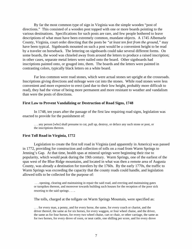
By far the most common type of sign in Virginia was the simple wooden “post of directions.” This consisted of a wooden post topped with one or more boards pointing to the various destinations. Specifications for such posts are rare, and few people bothered to leave descriptions of what must have been extremely common, mundane objects. A 1745 Albemarle County, Virginia, court order directing that the posts be “at least ten feet from the ground,” may have been typical. Signboards mounted on such a post would be a convenient height to be read by a traveler on horseback. The lettering on signboards could take several different forms. On some boards, the wood was chiseled away from around the letters to produce a raised inscription; in other cases, separate metal letters were nailed onto the board. Other signboards had inscriptions painted onto, or gouged into, them. The boards and the letters were painted in contrasting colors, typically black letters on a white board.
Far less common were road stones, which were actual stones set upright at the crossroads.
Inscriptions giving directions and mileage were cut into the stones. While road stones were less convenient and more expensive to erect (and due to their low height, probably more difficult to read), they had the virtue of being more permanent and more resistant to weather and vandalism than were the posts of directions.
First Law to Prevent Vandalizing or Destruction of Road Signs, 1748
In 1748, ten years after the passage of the first law requiring road signs, legislation was enacted to provide for the punishment of:
. . . any person [who] shall presume to cut, pull up, destroy, or deface any such stone or post, or the inscriptions thereon.
First Toll Road in Virginia, 1772
Legislation to create the first toll road in Virginia (and apparently in America) was passed in 1772, providing for construction and collection of tolls on a road from Warm Springs to Jenning’s Gap. At that time, health spas at mineral springs were beginning their rise to popularity, which would peak during the 19th century. Warm Springs, one of the earliest of the spas west of the Blue Ridge mountains, and located in what was then a remote area of Augusta County, was already a destination for travelers by the 1760s. By the early 1770s, the traffic to Warm Springs was exceeding the capacity that the county roads could handle, and legislation allowed tolls to be collected for the purpose of:
. . . opening, clearing and maintaining in repair the said road, and erecting and maintaining gates or turnpikes thereon, and moreover towards building such houses for the reception of the poor sick resorting to the said springs . . . . The tolls, charged at the tollgate on Warm Springs Mountain, were specified as:
. . . for every man, a penny, and for every horse, the same, for every coach or chariot, and the driver thereof, the same as for six horses, for every waggon, or four wheel chaise, and the driver, the same as for four horses, for every two wheel chaise, cart or chair, or other carriage, the same as for two horses, for every drove of oxen, or neat cattle, one shilling per score, and for every drove
8
of hogs, sheep, or goats, three pence per score, and so in proportion for a greater or lesser number . . . This road followed the corridor of modern Route 250 from Jennings Gap (west of
Churchville in Augusta County) to its intersection with Route 629. It then followed the corridor of Route 629 into Bath County, to Route 39, and thence to Warm Springs.
9
Virginia Transportation Innovations and New Technology—Then and Now: Part III: 19th Century Innovations in Transportation in Virginia
Ann B. Miller
[“Backsights” (Series 2) No. (2)1c: originally published in The Road Ahead, March 2001]
During the 19th century, most roads in Virginia continued under county control. However, in contrast to the preceding two centuries, there were numerous technological innovations as well as administrative advances in transportation in Virginia during the 19th century. There were improvements in bridges (including truss bridges) and in road paving. Also, the advent of railroads in Virginia as well as the first statewide transportation body both occurred during the 19th century.
First “Artificial” (Paved) Road in Virginia (About 1808)
The Manchester Turnpike (established 1801) was the first road in the Commonwealth to have a paved surface of any kind. The turnpike ran from Manchester (on the south bank of the James River, opposite Richmond) to the Falling Creek coal mines in Chesterfield County, a distance of 12 miles. By 1808, the surface of the road was covered with gravel, and it was described as being able to carry wagons weighing 4 tons. The right-of-way was 36 feet wide. The total cost of construction was $50,000, although the final 4 miles were constructed for $3,000 per mile. First Statewide Transportation Body, First Statewide Transportation Fund, and First Statewide Transportation Engineer (1816)
In 1815, the General Assembly’s newly organized Committee of Roads and Internal Navigation issued a report citing the many construction problems faced by the county road surveyors. The report also noted the need for better coordination of major internal improvements at the state level, as opposed to the fragmented efforts of the individual counties. The Board of Public Works (BPW), created in 1816, was not only the first statewide transportation body in Virginia, it was the earliest such group in the United States. It was formed for the general oversight of all forms of internal improvement and transportation in Virginia. At the same time as the creation of the BPW, a special statewide transportation fund (initially a little more than $1 million) was created, originally for the purpose of constructing canals and building roads to connect these canals. The post of Principal Engineer was also created at this time. The BPW’s first three Principal Engineers—Laommi Baldwin (1816-1818), Thomas Moore (1818-1822), and Claude Crozet (1823-1831 and 1838-1843)—had great influence on the technology of road building and bridge construction in Virginia. The hiatus between Crozet’s terms as Principal Engineer reflected his ongoing conflict with the legislature over the direction of Virginia’s transportation policy, particularly regarding Crozet’s promotion of railroads rather than the canals favored by many legislators. Following the first major policy disagreement in 1831, which resulted in the reduction of his salary and the reorganization of the
10
Board of Public Works, Crozet resigned, but returned to the post in 1838. Following further controversy over Crozet’s continued recommendation of railroad improvements, the post of principal engineer was abolished in 1843.
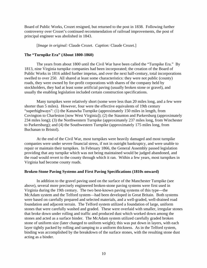
[Image in original: Claude Crozet. Caption: Claude Crozet.] The “Turnpike Era” (About 1800-1860)
The years from about 1800 until the Civil War have been called the “Turnpike Era.” By 1813, nine Virginia turnpike companies had been incorporated; the creation of the Board of Public Works in 1816 added further impetus, and over the next half-century, total incorporations swelled to over 250. All shared at least some characteristics: they were not public (county) roads, they were owned by for-profit corporations with shares of the company held by stockholders, they had at least some artificial paving (usually broken stone or gravel), and usually the enabling legislation included certain construction specifications.
Many turnpikes were relatively short (some were less than 20 miles long, and a few were shorter than 5 miles). However, four were the effective equivalents of 19th century “superhighways”: (1) the Kanawha Turnpike (approximately 150 miles in length, from Covington to Charleston [now West Virginia]); (2) the Staunton and Parkersburg (approximately 234 miles long); (3) the Northwestern Turnpike (approximately 237 miles long, from Winchester to Parkersburg); and (4) the Southwestern Turnpike (approximately 175 miles long, from Buchanan to Bristol).
At the end of the Civil War, most turnpikes were heavily damaged and most turnpike
companies were under severe financial stress, if not in outright bankruptcy, and were unable to repair or maintain their turnpikes. In February 1866, the General Assembly passed legislation providing that any turnpike which was not being maintained would be judged abandoned, and the road would revert to the county through which it ran. Within a few years, most turnpikes in Virginia had become county roads. Broken-Stone Paving Systems and First Paving Specifications (1810s onward)
In addition to the gravel paving used on the surface of the Manchester Turnpike (see above), several more precisely engineered broken-stone paving systems were first used in Virginia during the 19th century. The two best-known paving systems of this type—the McAdam system and the Telford system—had been developed in Great Britain. Both systems were based on carefully prepared and selected materials, and a well-graded, well-drained road foundation and adjacent terrain. The Telford system utilized a foundation of large, uniform stones that were carefully washed and graded. These were overlaid with smaller, irregular stones that broke down under rolling and traffic and produced dust which worked down among the stones and acted as a surface binder. The McAdam system utilized carefully graded broken stone of uniform size (later changed to uniform weight); this was put down in layers, with each layer tightly packed by rolling and tamping to a uniform thickness. As in the Telford system, binding was accomplished by the breakdown of the surface stones, with the resulting stone dust acting as a binder.
11
By the late 1810s, both systems were being recommended by Laommi Baldwin, the first Principal Engineer of the Board of Public Works. For stone-surfaced roads in Virginia, Baldwin also specified a related paving system, basically a hybrid between the Telford and McAdam systems, which was put down in three layers. Baldwin’s specifications were the first road paving specifications in Virginia:
. . . a road bed thirty feet wide into which are placed large stones well beaten close to each other over the whole width. Upon this is another bed of stones broken to the size of about four inches, well hammered and rammed in, so as to fill all the cavities between the under stratum of large stones. The third and last layer should be coarse gravel or stone broken to the size of hickory nuts, thrown on evenly or rammed or rolled with a heavy iron roller. The first should be from a foot to eighteen inches thick, the second 12 inches, and the last about 10 inches in the middle and 8 at the sides. Other broken-stone paving systems came to be referred to under the general name of
“McAdam” or “macadamizing.” The first documented uses of this technology in Virginia include the Fauquier and Alexandria Turnpike Company (1824), and the Lynchburg and Salem Company (1827), although then-principal engineer Claude Crozet criticized these companies for allowing their contractors to use stones too large to pack and crush easily, thus preventing good binding of the road surface, and producing a shifting, slippery road surface that presented hazards to draft animals. Other turnpikes that were macadamized with more conventionally sized stones and were carefully constructed and maintained became known for their good quality. However, due to the expense and labor involved, broken-stone paving remained fairly rare in the Commonwealth. Well into the 20th century, the majority of Virginia’s roads were surfaced primarily with the native soil, and perhaps a small amount of broken stone or gravel spread on the roadbed. Not surprisingly, many of these roads were impassible for parts of the year, particularly following heavy rains, and after the spring thaw. Improvements in Bridges (Early 19th Century Onward)
The 19th century saw various improvements in bridges. Among these were various new timber truss bridges such as the Burr arch truss (developed in the first decade of the 19th century), early 19th century patented varieties such as the Town lattice truss (1820), and the combination wood-and-iron Howe truss (1840). Since many varieties of wooden bridges needed constant maintenance and deteriorated quickly, a variety of methods were tried to improve the effective lifespan of these bridges. The addition of roofs and boarding on wooden truss bridges, placed to protect the timbers from the elements and prevent rotting, produced “covered bridges.”
Metal truss bridges were first developed in the 1840s and 1850s, but they did not appear
in many areas of Virginia until the 1870s. Seen as a longer-lasting, lower maintenance alternative to wooden bridges, metal truss bridges began to supersede wooden trusses in Virginia during the last quarter of the 19th century. For short spans (under 40 feet), bridges with iron (later steel) I-beams instead of wooden beams began to gain popularity. During the last quarter of the 19th century, steel began to replace iron in bridge construction, and by 1890, virtually all new metal truss bridges were constructed of steel. However, although longer-lasting than most wooden bridges, metal bridges still required consistent maintenance, particularly painting, and the cost of upkeep was a constant drain on county budgets. It was common practice among
12
county governments to delay or ignore what should have been routine maintenance on metal bridges in an effort to stretch dollars, and this resulted in deterioration and damage to bridges.
This 1887 bridge is one of the 18 metal truss bridges built before 1900 still standing in Virginia. Originally erected as a railroad bridge, it was moved to its present location in Botetourt County in 1903 to serve the Craig Valley branch of the Chesapeake & Ohio Railroad. The old railroad right-of-way was abandoned in the 1950s, and was purchased by the Virginia Department of Highways (now VDOT) in 1961. This bridge now carries Rt. 685, which occupies the old railroad route. Built by the Phoenix Bridge Company of Phoenixville, Pennsylvania, this bridge utilizes the patented modular Phoenix column for its compression members and is constructed in the pin-connected Pratt truss configuration. It was placed on the Virginia Historic Landmarks Register and the National Register of Historic Places in 1975.
A relatively small number of stone bridges were constructed in Virginia in the 19th
century. Beautiful and strong, yet expensive in terms of cost and time, stone masonry, particularly masonry arch bridges, remained relatively rare in Virginia throughout the 19th century. This was largely due to the cost, time, and skill involved in construction, as well as the need for suitable sources of stone and mortar. Early 19th century examples were largely confined to stone arch turnpike bridges. Later in the century, stone masonry abutments for wooden and metal truss bridges were used, and in the last half of the century, stone arch railroad bridges were constructed.
[Image in original: Falling Creek bridge. Caption: The masonry arch bridge shown here is one of Virginia’s oldest standing bridges. Built about 1823 by the Manchester and Petersburg Turnpike Company, this structure is typical of a bridge type that was used by various turnpike companies, but due to the time, skill, and expense involved in masonry construction, it was seldom used by county bridge builders. This structure was closed to vehicular traffic in the early 1930s, and one of the first waysides in Virginia was designed around the old bridge, which still serves as a footbridge and landscape feature at the Falling
13
Creek Wayside in Chesterfield County. [NOTE: The Falling Creek bridge was partly destroyed by flooding in 2004: see The Falling Creek Bridge, “Backsights” No. (2)6a, March 2005, and No. (2)b, June 2005.]
Canals (Early to Mid-19th Century)
A major initiative of the Board of Public Works was to promote the construction of canals and the roads to connect these canals in order to provide a transportation and market connection between the Fall Line port towns and the western areas of Virginia. During the first half of the 19th century, various canal companies were incorporated, and canals were constructed at various locations through the Piedmont and into the Valley of Virginia. Unfortunately, the period of completion of most of these canals coincided with the arrival of railroads to the same regions, promoting a rapid decline of most of the canal companies.
The James River & Kanawha Canal, the last major long-distance canal in Virginia, survived with steadily mounting financial and physical problems into the 1870s. In 1880, it was acquired by the Richmond & Alleghany Railway Company (later the Chesapeake & Ohio R.R.), which built track along the old canal and converted the route into a railroad line.
[Image in original: Confederate soldiers being transported by canal. Caption: Confederate troops on canal freight boat (Summer 1861).]
Steam Locomotives and Railroads (1830s Onward)
The first railways consisted of horse-drawn cars that ran on wooden or metal tracks. Early steam locomotives were tested in Great Britain during the first decade of the 19th century, and similar machines were in limited British commercial use in the 1810s. Between 1825 and 1830, several steam locomotives were built or imported into America. By the 1830s, railroads for steam locomotives were under construction in Virginia. Although many state officials and legislators attempted to promote canals at the expense of railroads, public opinion was against them, and railroads quickly eclipsed the canal system.
[Image in original: Early locomotive. Caption: “Old Ironsides,” a five-ton locomotive, was built by Matthias W. Baldwin, and made its trial run November 23, 1832, on the Philadelphia, Germantown and Norristown Railroad. The wheels were made with heavy cast-iron hubs, wooden spokes and rims, and wrought-iron tires. The tender was a four-wheeled platform with wooden sides and back, enclosed in a wooden casing, and with a space for fuel in front. Similar locomotives were used in Virginia during this period.]
Plank Roads (1840s-1850s)
Sometimes known as “farmers’ railroads,” plank roads were a popular innovation of the mid-1830s. The trend reached Virginia by the mid-1840s, and over the next 15 years a number of plank roads were constructed in the state. Plank road construction was extremely simple. As noted in a roadmaking manual of the era:
14
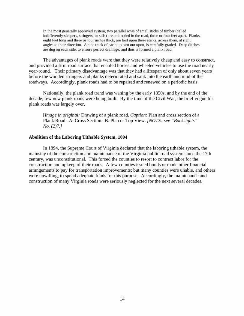
In the most generally approved system, two parallel rows of small sticks of timber (called indifferently sleepers, stringers, or sills) are embedded in the road, three or four feet apart. Planks, eight feet long and three or four inches thick, are laid upon these sticks, across them, at right angles to their direction. A side track of earth, to turn out upon, is carefully graded. Deep ditches are dug on each side, to ensure perfect drainage; and thus is formed a plank road. The advantages of plank roads were that they were relatively cheap and easy to construct,
and provided a firm road surface that enabled horses and wheeled vehicles to use the road nearly year-round. Their primary disadvantage was that they had a lifespan of only about seven years before the wooden stringers and planks deteriorated and sank into the earth and mud of the roadways. Accordingly, plank roads had to be repaired and renewed on a periodic basis.
Nationally, the plank road trend was waning by the early 1850s, and by the end of the decade, few new plank roads were being built. By the time of the Civil War, the brief vogue for plank roads was largely over.
[Image in original: Drawing of a plank road. Caption: Plan and cross section of a Plank Road. A. Cross Section. B. Plan or Top View. [NOTE: see “Backsights” No. (2)7.]
Abolition of the Laboring Tithable System, 1894
In 1894, the Supreme Court of Virginia declared that the laboring tithable system, the mainstay of the construction and maintenance of the Virginia public road system since the 17th century, was unconstitutional. This forced the counties to resort to contract labor for the construction and upkeep of their roads. A few counties issued bonds or made other financial arrangements to pay for transportation improvements; but many counties were unable, and others were unwilling, to spend adequate funds for this purpose. Accordingly, the maintenance and construction of many Virginia roads were seriously neglected for the next several decades.
15
Virginia Transportation Innovations and New Technology—Then and Now: Part IV: Early 20th Century Innovations in Transportation in Virginia
Ann B. Miller
[“Backsights” (Series 2) No. (2)1d: originally published in The Road Ahead, June 2001]
The invention of the automobile and its rapid and wide acceptance as a means of transportation has a profound effect on the development of the road system in Virginia in the early part of the 20th century. To a large extent, the widespread use of automobiles forced a variety of technological developments in road building and in many other aspects of the transportation system. The First Automobiles in Virginia (About 1900)
A kerosene-fueled “horseless carriage,” driven in Norfolk in 1899, is believed to have been the first automobile driven in Virginia. The number of automobiles in the Commonwealth grew slowly over the next decade, largely due to the lack of suitable roadways, and it was nearly a decade before the number of automobiles reached 2,500. By the early 1910s, however, the number of motor vehicles in Virginia began to skyrocket. By 1913, over 10,000 were registered in Virginia; by 1916, over 37,000; and by 1918, 145,000. By 1930, there were 386,664 motor vehicles registered in Virginia. Abolition of the Board of Public Works (1902)
In the last quarter of the 19th century, the primary concern of the Board of Public Works had moved away from transportation, and since 1884 it had been responsible for registering all the real and personal property of the state. In 1902, the Board of Public Works along with the late-19th century post of Railroad Commissioner were dissolved and their duties merged with those of the newly-formed State Corporation Commission, which regulated all corporations in Virginia, including those concerned with transportation. Creation of the State Highway Commission and Office of State Highway Commissioner (1906)
In 1906, the legislature created the first State Highway Commission. This was to be headed by a State Highway Commissioner appointed by the governor with General Assembly confirmation. The commissioner was required to be a citizen of Virginia and a civil engineer as well as “a person well-versed in road building.” The commission was to be made up of three professors of civil engineering, one from the University of Virginia, one from Virginia Military Institute, and one from Virginia Agricultural and Mechanical College and Polytechnic Institute (now Virginia Polytechnic Institute and State University [Virginia Tech]). The first state highway commissioner was Philip St. Julien Wilson, a VMI-educated engineer; the body of the first commission consisted of William M. Thornton (U.Virginia), Col. T. A. Jones (VMI), and Col. R. A. Marr (Virginia Polytechnic).
16
At this time, except for a few turnpikes, roads were still under county control. The legislation specified that the commissioner
shall have a general supervision of the construction and repair of the main traveled roads in the state; the Commissioner may recommend to the local road authorities of any county, and to the Governor, needed improvements in the public roads; he shall supply technical information on road-building to any citizen or officer in the state, and from time to time publish for public use such information as will be generally useful for road improvement. State monetary assistance for counties desiring help with transportation costs—“State
aid”—was established on a voluntary basis. The Virginia State Highway Commission would provide both design assistance and some funding to the counties. While transportation systems remained under the control of the counties, any counties wishing assistance could apply to the commissioner for engineering advice on proposed road improvements. The same legislation established a state convict road force as a source of labor for road maintenance and construction.
The expenditure (salaries and expenses) for the first fifteen months of operation (July 1, 1906 to October 1, 1907) was $10,677.23. First Improvement Project Completed with the Help of the State Highway Commission (1906-1907)
The first highway project completed with the help of the State Highway Commission was the improvement of the road between Williamsburg and Jamestown Island, which was begun in December 1906 and completed in July 1907, in time for the festivities surrounding the 300th anniversary of the founding of Jamestown. The majority of the 8.02-mile stretch of roadway was of gravel and sand-clay; approximately two miles were macadamized. First Highway Specifications (for Macadam Roads) Issued by the State Highway Commission (1907) The first report of the State Highway Commissioner (1907) included recommended specifications for macadam roads. This included specifications for stone size, culvert construction (both pipes and concrete), preparing the roadway, and shaping roadbeds (i.e., road crowns, banks, drains, gutters, ditches). Additional specifications for other types of roads were subsequently issued. First Construction Appropriation (1908) With the need for improved roads and bridges becoming increasingly apparent, the legislature made its first appropriation for construction purposes in 1908: $25,000 annually, beginning March 1, 1909. Intended primarily for counties where convict labor was not available, state funding was to be equally matched by counties that received the funds. At this time, state law directed counties to levy a road tax of up to 40 cents for each $100 in assessed value on real estate and personal property. This funding was to cover the counties’ share of improvement and road equipment costs.
17
(Above) Section of road in Amherst County. (Below) The same section of road three months later after
improvement. These photographs are taken from the First Annual Report of the State Highway Commissioner (1907).
Adoption of First Standard Plans for Bridges in Virginia (1909) Towards the end of the first decade of the 20th century, state-mandated standards for bridge design were instituted. In 1908, legislation provided that if highway projects were permanent, located on main roads, and were deemed to be “adequate and practical,” the commissioner's office would:
18
. . . carefully prepare plans, specifications and estimates of cost for its construction with the materials agreed upon between the local road authorities and the commissioner . . . If the local road authorities shall then decide to improve or construct said road or part thereof in accordance with the plans and specifications recommended and submitted by the commissioner, they may then apply to the State Highway Commissioner for such State aid . . . as may be obtained under the provisions of this chapter . . . (Acts of Assembly, 1908).
However, the condition of many bridges was soon recognized as not only unreliable but
unsafe and even critical, and mandatory bridge standards were required. The 1909 Annual Report of the State Highway Commission noted that:
Old wooden structures and steel bridges imperfectly designed are frequently found on the most heavily traveled highways, and are often in dangerous condition. This department desiring to meet these conditions has striven to lend assistance not only to counties where we are giving State aid on permanent bridges, but to all counties asking for such assistance. After a careful study of the needs and desiring that bridges should be designed and erected according to some specifications which could be used and lived up to as standard by the State and county, this department, last July, issued ‘General Specifications for Steel Highway Bridges.’ . . . Wherever practical reinforced concrete spans have been used. This type of construction requires no maintenance, and its strength increases instead of diminishing with age. Spans from five to fifty feet in length have been designed and constructed. In cases where reinforced concrete cannot be used economically, steel is being employed. Steel bridges from fifteen to five hundred and eighty feet in length have been or are being erected according to the plans of this department and under its supervision.
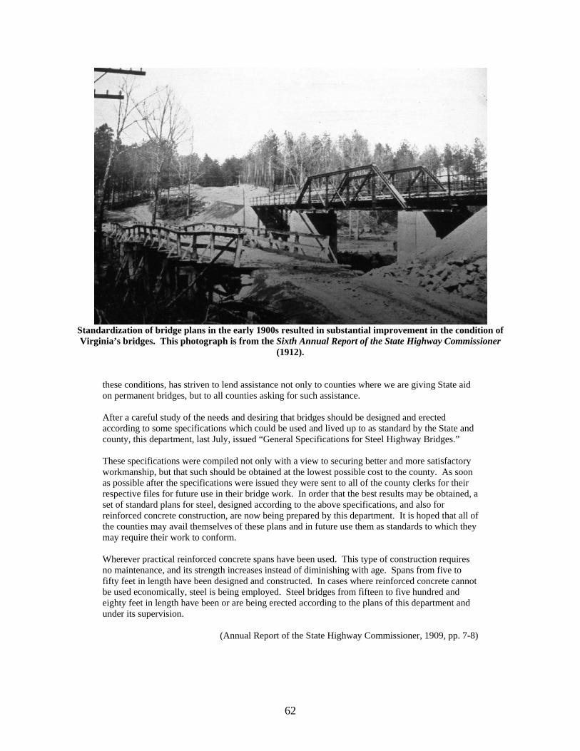
[Image in original: An old bridge and its replacement. Caption: Before and after state-mandated standards. This photograph is taken from the Sixth Annual Report of the State Highway Commissioner (1912). [NOTE: See Backsights No. (2)12.]
Registration and Licensing of Automobiles (1910)
By 1910, with slightly over 2700 automobiles in Virginia, legislation was passed to require the registration and licensing of motor vehicles. Registration fees were $5 for automobiles of 20 horsepower or less, $10 for those with between 20 and 45 horsepower, and $20 for those with over 45 horsepower. A $2 registration fee was also set for motorcycles, 235 of which were registered. These fees were put into the state treasury as a special fund for the improvement of major roads. The total statewide revenue from the first year’s registration fees was $21,656. First Speed Limits (1910) Speed limits were enacted the same year as the first registration and licensing of cars in Virginia. Twenty miles per hour was the top speed allowed in open country, while eight miles per hour was the limit in cities and towns, on curves, and at major intersections. First Concrete Road in Virginia (1913)
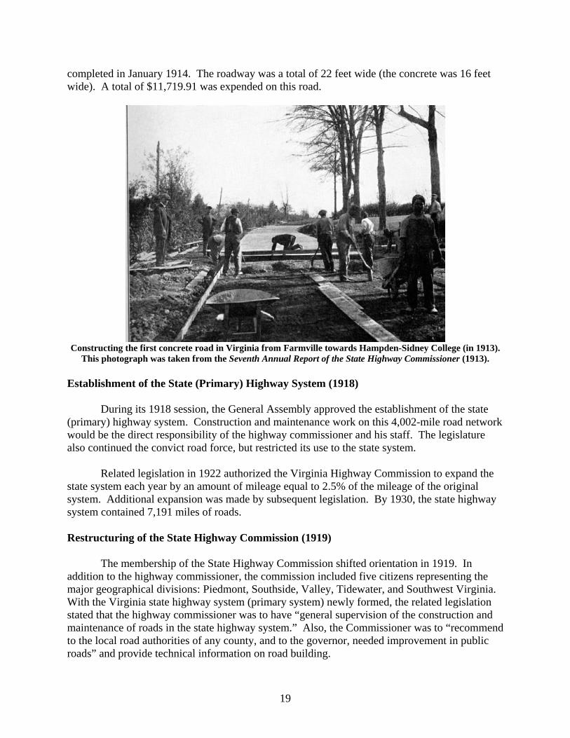
The first concrete road in Virginia, a 0.9-mile stretch running from Farmville towards Hampden-Sidney College in Prince Edward County, was begun in September 1913 and
19
completed in January 1914. The roadway was a total of 22 feet wide (the concrete was 16 feet wide). A total of $11,719.91 was expended on this road.
Constructing the first concrete road in Virginia from Farmville towards Hampden-Sidney College (in 1913).
This photograph was taken from the Seventh Annual Report of the State Highway Commissioner (1913). Establishment of the State (Primary) Highway System (1918)
During its 1918 session, the General Assembly approved the establishment of the state (primary) highway system. Construction and maintenance work on this 4,002-mile road network would be the direct responsibility of the highway commissioner and his staff. The legislature also continued the convict road force, but restricted its use to the state system.
Related legislation in 1922 authorized the Virginia Highway Commission to expand the
state system each year by an amount of mileage equal to 2.5% of the mileage of the original system. Additional expansion was made by subsequent legislation. By 1930, the state highway system contained 7,191 miles of roads.
Restructuring of the State Highway Commission (1919)
The membership of the State Highway Commission shifted orientation in 1919. In addition to the highway commissioner, the commission included five citizens representing the major geographical divisions: Piedmont, Southside, Valley, Tidewater, and Southwest Virginia. With the Virginia state highway system (primary system) newly formed, the related legislation stated that the highway commissioner was to have “general supervision of the construction and maintenance of roads in the state highway system.” Also, the Commissioner was to “recommend to the local road authorities of any county, and to the governor, needed improvement in public roads” and provide technical information on road building.
20
In 1942, the commission was expanded to include one member from each of the eight highway districts (established in 1922). A rural-at-large member and an urban-at-large member were added in 1974, and in 1974 an additional member was added to represent the new Northern Virginia highway district. The commission underwent two changes of name: to the Virginia Highway and Transportation Commission (1974) and to the Virginia Highway and Transportation Board (1985). After the 1987 expansion of membership and duties, and a name change to the Commonwealth Transportation Board, the board reached its present configuration. Geographical Divisions and Reorganization (1922)
In 1922, legislation directed that Virginia was to be divided into eight highway districts, a system that is still essentially intact (today’s NOVA district was then part of Culpeper district; Staunton district originally contained Albemarle County). Available funds were to be equally divided among the newly formed districts. Each district was further subdivided into residencies. In 1922, each district had between 3 and 5 resident engineers. (By 1942, Virginia highway districts had between 5 and 9 resident engineers. The number has now readjusted slightly.)
Also in 1922, Henry Garnett Shirley, formerly the highway administrator for Maryland,
was appointed chairman of the Virginia State Highway Commission. Virginia highway commissioner George Coleman stayed on until his resignation the following year, and the positions of chairman and commissioner were subsequently combined. Under Shirley’s administration, the highway department reached much of its present structure. He served until his death in 1941. Creation of the Department of Highways (1927) As part of a reorganization of state government, the Department of Highways was formally established as a state agency in 1927 (although the highway commission had been informally known as the “highway department” since its inception). First Standard Highway Signs in Virginia (late 1920s) Prior to the 1920s, there were no consistent standards for highway signs. Each state, and often each county, utilized its own designs. In 1925, the American Association of State Highway Officials promoted the nationwide use of standard signs, as well as a standard numbering system for principal roads. In 1927, a joint board of federal and state highway officials published the first manual for this numbering system as well as standard sign details. This led to the beginning of route numbers and uniform signs to mark major (primary) roadways in Virginia as well as the rest of the nation. However, numbering and marking Virginia’s local roads with standardized signs had to wait until after the establishment of the state secondary system (1932). Creation of the State Secondary System (1932) Even as the number of motor vehicles in Virginia increased and recommended standards for roads continued to develop, county road systems in Virginia remained generally poor. Many counties were unable or unwilling to spend sufficient funds to maintain and improve their roads.
21
Most counties did not have adequate construction equipment and few had engineers on their staff.
Under the provisions of the Byrd Road Act, counties could transfer the responsibility for
their roads to the State Highway Commission. Only four counties—Arlington, Henrico, Nottoway, and Warwick (now part of the city of Newport News)—chose to retain responsibility for their roads. (Nottoway reversed its decision and transferred its road responsibility to the state in 1933.) The remaining county roads were taken into what became the state secondary system. As established, the secondary system contained 35,900 miles of roads. Of these, only 2,000 miles were hard surfaced and 8,900 miles had soil or gravel surfaces. The remainder, some 25,000 miles (nearly 70% of the system), were unimproved dirt roads. Over the next ten years, the mileage of hard-surfaced roads tripled and that of soil or gravel roads doubled, while the mileage of unimproved roads was cut by almost half.
22
“Lost the Road”: Recently-Discovered Nineteenth Century Road Signs from Virginia
Ann B. Miller
[“Backsights” (Series 2) No. (2)2: originally published in The Road Ahead, October 2003]
A previous “Backsights” article, originally published in 1983, showed an early 19th century British print by Thomas Rowlandson, “Dr. Syntax Losing His Way.” The illegible road signs that caused the good doctor’s lack of direction was not only a British problem, however. The same scene could well have been placed in Virginia during the 18th or 19th centuries.
Following similar British legislation, a Virginia statute of 1738 required that posts of
directions be erected at all places “where two or more Cross-roads or highways meet,” with “inscriptions thereon in large letters directing to the most noted place to which each of the said Joyning roads leads.” Specifications for such posts are rare. Few people bothered to leave descriptions of what must have been extremely common, mundane objects. A 1745 Albemarle County court order directing that the posts be “at least ten feet from the ground” may have been typical, as this is a convenient height to be read by a traveller on horseback.
The American Agriculturalist, vol. XXVIII, No. 8 (August 1869), carried an engraving from a sketch by Thomas Worth, titled “Lost the Road.” The sketch (which accompanies this article) shows an elderly couple faced with an illegible signboard and a similar situation to that of Rowlandson’s Dr. Syntax a half-century earlier. Discussing what was apparently a problem prevalent throughout the country, the Agriculturalist noted:
[the artist] has given a more forcible commentary upon the general neglect of guide-boards in this country than one could write upon a page. The old couple have brought out the venerable establishment, and are on their long-talked-of journey. In doubt about the road, they at length see a guide-board, but upon reaching it find the inscription effaced, and the board falling into decay. In riding in a strange neighborhood it is pleasant for one to feel that he is on the right road. Neat guide-boards, put at all the important crossings, give one the needed information at sight, and the delay of stopping to make inquiries is avoided. The guide-board should be devoid of painters' flourishes, with only the necessary direction in plain black letters upon a white ground. Good black paint is wonderfully indestructible, and we can call to mind old country guide-boards in which the letters stand out in strong relief, the wood around them having been worn away by the action of the elements. Iron letters are sometimes used, nailed to the board, and very neat guide and milestones combined, are sometimes to be met with. These helps to the traveler, together with convenient road-side watering-places, give a neighborhood an air of refinement.
Only one set of pre-20th century wooden signboards from an early “post of directions” is
known to survive in Virginia. The background of the signboards was painted white, while the letters were painted black. The area of the signboards around the letters appears to be whittled or routed so that letters are raised approximately 1/16″, possibly to facilitate application of black paint to the letters using a roller or similar tool. (Cuts and marks from what appears to be a knife or woodworking tool make it appear unlikely that the raised letters are the results of weathering, in this case.) Directions are shown by stylized hands with pointing index fingers.
23
“Lost the Road.”
The 19th century road signs.
24
From mileage and directions on signboards, these signs apparently stood at or close to the intersection of present Rts. 638 and 603, west of Rt. 29 in Madison County. The boards apparently date to the last half of the 19th century, as Era Mills was set up in mid-century, and the name was changed to Zeus Mills in 1904. The boards were found in Madison County in 1994 in an old shed near Rt. 603, and are privately owned.
Images of these Madison County signboards accompany this article. The dimensions of image “A” (“ERA MILLS. 1 Ms. / CRIGLERSVILLE.6. Ms.”) are 50 1/8 inches by 7 15/16 inches by 1¼ inches. The board featured in image “B” (“MADISON. C. H. / 3. Ms.”) measures 26 15/16 inches by 7 11/16 inches by 1¼ inches.
25
“If 100 beeves get on it”—A Bridge for Raccoon Ford: Transportation Planning in the 1880s
Ann B. Miller
[“Backsights” (Series 2) No. (2)3: originally published in The Road Ahead, December 2003]
In the late 19th century, transportation needs and structures design had vastly different considerations than in the present day. Orange County farmer, lawyer, and businessman J. J. Halsey wrote the letter quoted below, dated April 6, 1882, to Judge John W. Bell.
Halsey, who lived at “Lessland” in north central Orange County, was one of a number of
local agriculturalists who saw the need for improved transportation (particularly for farm-to-market access), and had lobbied the Orange and Culpeper county governments for a bridge across the Rapidan River at Raccoon Ford (near the crossing of modern Route 522). The following is an exact transcription of the original letter, written in an era before spelling, capitalization, abbreviation, and punctuation became fully standardized.
Dear Sir, It being uncertain whether I can attend April Court, I beg leave to submit this Explanation
to accompany our report on the Raccoon Ford Bridge Question, - & which may be filed therewith if you deem it worth filing.
The necessity & mutuality of interest of both Counties is apparent from this, amongst other Considerations – Culpeper farmers ship wheat to Fredsbg [Fredericksburg] via narrow gauge. Corn to Lynchburg & south – & to get to their Mill on Orange side is a matter of large local interest. Orange, ships Cattle & sheep bought by Culpeper & Rappk. [Rappahannock] men, towards Baltimore, & graziers often pass us with stock bought in Spottsylvania, South Orange & Louisa.
Orange deals largely in sheep & lambs. To get 240 (a carload) over the river when
fordable by a horse, is a weekly problem in the spring. They have to be hauled over in wagons. –
A heavy trade going East is constantly going on, and a disappointment in getting stock over, is a weeks loss, & affects buyers, sellers, & railroad Co. [company] when cars are sent to meet the stock alike – Hence a road bridge for this point must be good for all purposes. If 100 beeves get on it (50 to 60 tons) it must bear their motions whether quiet or fighting for place. To escape high water & give room for a flood to pass, it must stand 15 high & be 167 feet long. It should therefore be thoroughly strong & safe. –
The Commissioners spent much time in Examining the various plans, & closely
questioning the Agts [agents] of the Builders – I spent 16 hours hard work figuring out the strength &c of these Bridges – & comparing them, & reported the Canton bridge the “cheapest for the money” & the best; warranted to sustain 80 tons of cattle or anything Else. –
Wooden bridges not covered in won’t last 10 years. Culpeper has Experience in amts [amounts] paid Bruce first for reps [repairs] $300, then new bridge $2000+ at Hazel (Rixeys) and again over Hedgeman [River] at Springs. Orange tried it at Liberty Mills – now of iron – Now a long narrow wood bridge 16 ft. high & standing 15 feet in air, is liable to be blown over by March wind – Is liable to fire, & standing over water, will rot at bottom anyway.
26
The Combination bridges, that is End & all vertical posts wood, & top chord in 15½ feet sections (pannel length) wood will give way in 10 years too, & no one here can replace a piece as it gives way. The whole bridge has to be jacked up & trussed whilst new pieces are put in – The certainty of needed repair, & difficulty of making it, (an Engineer of one of the Cos. telling us plainly it would require a mechanic & their fixtures from the works to do it) condemned these with as. – We were then to choose between the best wrought iron & wood. The bridge offered at $28 per foot is really a $30 per foot bridge – The agt. [agent] furnished me with amount of iron in it 61000 lbs – Put this at 6.¢ a pound manufactured & it comes to $3660. leaving $1015. to get it here, & put it up & furnish lumber for road way, &c. – I am satisfied it cannot be had for less; & if present demand for iron of lower grade continues, the best No 1 iron (every bar tested) will soon advance.
Of course the Co is a strong one, as they all are, & can wait for ½ their pay anyway; but it
bears interest – Our idea was, to get a thorough bridge safe, & once done always done. No repairs, no danger of fire or wind and a bridge for universal use – It is a great mistake to consider it a mere local matter. People about Raccoon Ford, will be less benefitted than men who live miles away, & who cannot calculate what a few hours rain, will do – I think it proper the Court should Know the basis of the action of the Commrs [commissioners] & I therefore submit the above. Very truly yours &c
J.J. Halsey
As is obvious from Halsey’s letter, flooding and high water seriously impacted the ability
of the era’s farmers to move produce and livestock. The uncertain conditions of the river made it particularly difficult for them to reliably reach the local railroads for shipment of their farm products. Issues of access to multi-modal transportation centers and reliable transportation corridors remain familiar to today’s planners. However, other issues such as periodic 60-ton live loads of “100 beeves” [cattle] which might start “fighting for place” are no longer primary considerations.
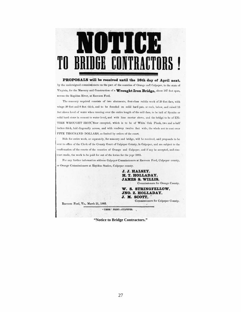
Although the county supervisors had agreed to the building of a bridge at the site, the exact type of structure was still in doubt. Along with other interested parties, J. J. Halsey had been appointed a commissioner to address the question of the bridge and to eventually receive proposals for its construction. As can be seen from his letter, both strength and minimal maintenance were strong considerations for both him and the other commissioners, and Halsey argued strongly against the traditional wooden trusses, and firmly in favor of a state-of-the-art metal truss bridge. This argument prevailed, and the “Notice to Bridge Contractors” pictured with this article was issued by Halsey and the other bridge commissioners in March 1883.
The Raccoon Ford bridge built as a result of this advertisement was damaged by
subsequent flooding; a rebuilt bridge stood until the flood of 1942.
(The Halsey letter transcribed in this article comes courtesy of Orange County resident Patricia J. Hurst of Rapidan, and is included in her upcoming history of life along the Rapidan River.)
27
“Notice to Bridge Contractors.”
28
A “Route of Lee’s Retreat” Marker
Ann B. Miller and John E. Wells
[“Backsights” (Series 2) No. (2)4: originally published in The Road Ahead, March 2004]
With the advent and expansion of automobile use in the 20th century, tourism became an increasingly popular leisure activity in both Virginia and the U.S. as a whole. In the early 20th century, the era before standard highway signs, directions to various destinations were often haphazard, and signs—if they existed at all—were frequently crudely made. Even after directional signs became standardized after the late 1920s and early 1930s, the design of signs directing travelers to various popular attractions was undertaken by various public or private agencies, as well as by individuals. There was no single design mandate for signs of this type.
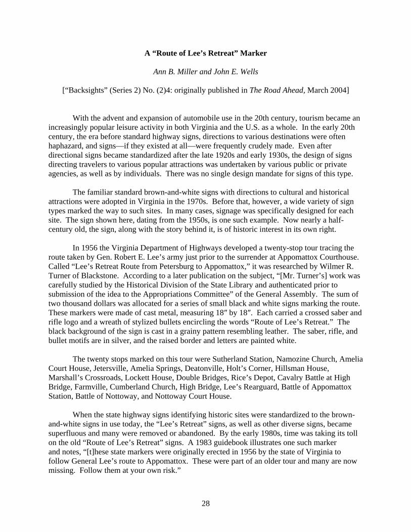
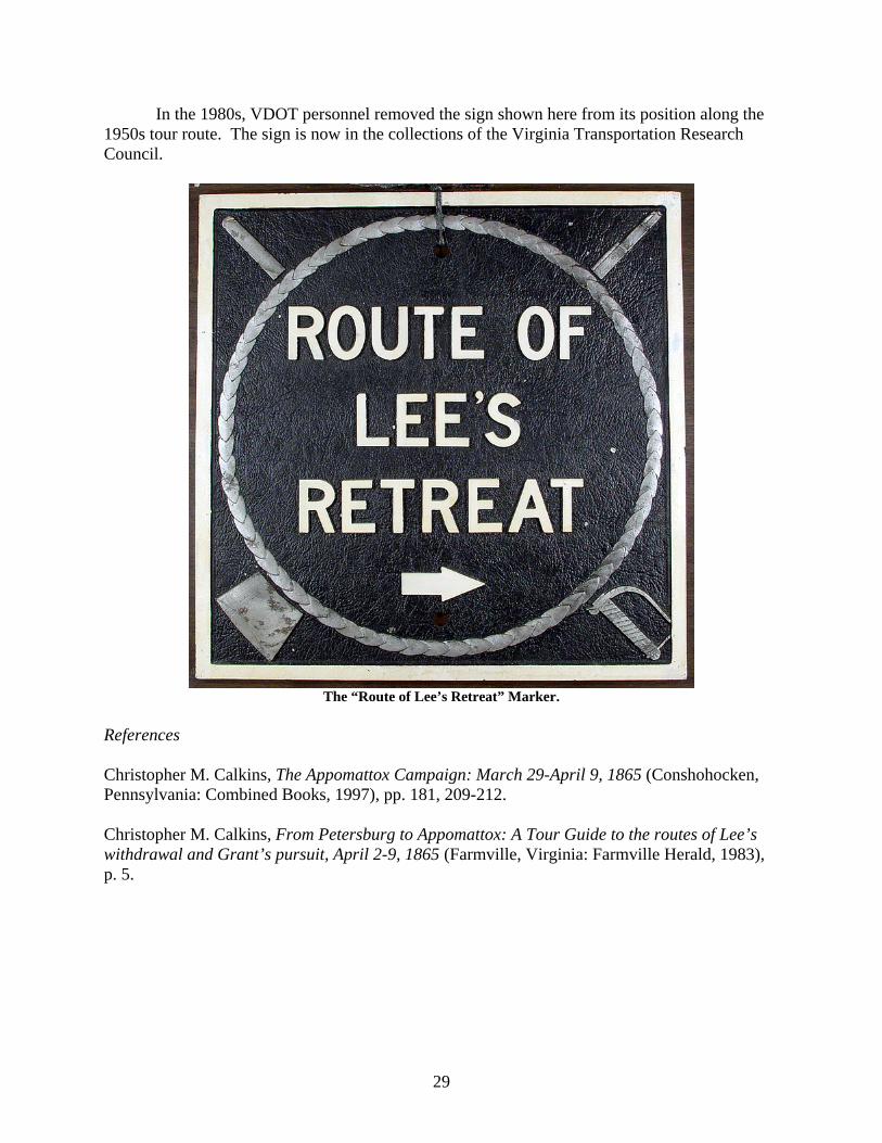
The familiar standard brown-and-white signs with directions to cultural and historical attractions were adopted in Virginia in the 1970s. Before that, however, a wide variety of sign types marked the way to such sites. In many cases, signage was specifically designed for each site. The sign shown here, dating from the 1950s, is one such example. Now nearly a half-century old, the sign, along with the story behind it, is of historic interest in its own right.
In 1956 the Virginia Department of Highways developed a twenty-stop tour tracing the
route taken by Gen. Robert E. Lee’s army just prior to the surrender at Appomattox Courthouse. Called “Lee’s Retreat Route from Petersburg to Appomattox,” it was researched by Wilmer R. Turner of Blackstone. According to a later publication on the subject, “[Mr. Turner’s] work was carefully studied by the Historical Division of the State Library and authenticated prior to submission of the idea to the Appropriations Committee” of the General Assembly. The sum of two thousand dollars was allocated for a series of small black and white signs marking the route. These markers were made of cast metal, measuring 18″ by 18″. Each carried a crossed saber and rifle logo and a wreath of stylized bullets encircling the words “Route of Lee’s Retreat.” The black background of the sign is cast in a grainy pattern resembling leather. The saber, rifle, and bullet motifs are in silver, and the raised border and letters are painted white.
The twenty stops marked on this tour were Sutherland Station, Namozine Church, Amelia
Court House, Jetersville, Amelia Springs, Deatonville, Holt’s Corner, Hillsman House, Marshall’s Crossroads, Lockett House, Double Bridges, Rice’s Depot, Cavalry Battle at High Bridge, Farmville, Cumberland Church, High Bridge, Lee’s Rearguard, Battle of Appomattox Station, Battle of Nottoway, and Nottoway Court House.
When the state highway signs identifying historic sites were standardized to the brown-
and-white signs in use today, the “Lee’s Retreat” signs, as well as other diverse signs, became superfluous and many were removed or abandoned. By the early 1980s, time was taking its toll on the old “Route of Lee’s Retreat” signs. A 1983 guidebook illustrates one such marker and notes, “[t]hese state markers were originally erected in 1956 by the state of Virginia to follow General Lee’s route to Appomattox. These were part of an older tour and many are now missing. Follow them at your own risk.”
29
In the 1980s, VDOT personnel removed the sign shown here from its position along the 1950s tour route. The sign is now in the collections of the Virginia Transportation Research Council.
The “Route of Lee’s Retreat” Marker.
References Christopher M. Calkins, The Appomattox Campaign: March 29-April 9, 1865 (Conshohocken, Pennsylvania: Combined Books, 1997), pp. 181, 209-212. Christopher M. Calkins, From Petersburg to Appomattox: A Tour Guide to the routes of Lee’s withdrawal and Grant’s pursuit, April 2-9, 1865 (Farmville, Virginia: Farmville Herald, 1983), p. 5.
30
The S. F. Memorial Stone: Virginia’s Oldest Surviving Roadside Memorial?
Ann B. Miller
[“Backsights” (Series 2) No. (2)5a: originally published in The Road Ahead, July 2004]
Over the past few decades, the practice of setting up roadside memorials at the scenes of deaths resulting from traffic crashes has become common in Virginia and elsewhere. What is not widely known, however, is that similar customs to memorialize roadside deaths existed centuries ago in various parts of the world, long before the advent of motorized vehicles.
Prior to the advent of modern roads and vehicles, travel in most areas was not only slow and inconvenient, but often a lonely and downright dangerous proposition. The danger of a lone individual or a small group of travelers being waylaid and killed by robbers or enemies was a common one. Sickness, injuries, and other accidents ended the lives of still other travelers. In sections of Europe, notably the Balkans, parts of central Europe, and the British Isles, various stone and wooden memorial structures were once common, and numbers still remain. In particular, there are numerous British examples of a wooden “dead man’s post,” or an inscribed stone marker or cross being erected at the site of a sudden, tragic (and often violent) death in the 17th through 19th centuries. These originally served several intentions—to identify what was often regarded as tainted ground, to memorialize the deceased, as a cautionary text, and, in some cases, to keep the ghost from walking.
These sorts of roadside memorials had representatives in Virginia as late as the early 20th century. The majority of them would have been made of wood, and typically took the form of posts with carved inscriptions, the same type of posts which were common in Britain. Although no such wooden posts are known to survive today, at least one early stone memorial is still in place.
This marker, pictured below, appears to be the oldest surviving roadside memorial in Virginia. It is also likely the most elaborate. Set against a road bank by the side of Route 684 in Powhatan County, it apparently dates to the mid 19th century. It consists of two separate stones: an upright carved and inscribed stone (approximately 47 inches high, 18 inches wide, and 15 inches deep) and a smaller angled carved stone in front which apparently braces or supports the upright stone. The inscription, carved on the upright stone, reads:
S : F NOV : 14 1840
MEMENTO MORI
According to local tradition, this site marks the site of a horseback riding or carriage
accident in which a member or acquaintance of the Cocke family of the surrounding Belmead plantation was killed. “S. F.” are said to be the initials of the deceased and November 14, 1840, the date of death. (It is uncertain whether “S. F.” refers to the first and middle names, or the first
31
The S. F. Memorial Stone.
and last names, of the deceased.) “Memento Mori” is a Latin phrase meaning “remember that you [too] shall die.” This reminder of the inevitability of death was a common inscription on gravestones and monuments of the era.
A 1952-53 Virginia Department of Highways report on waysides refers to this as a monument to “Sally Faukner.” Nothing else could be found on this name; however, several women of the Cocke family were named Sally Faulcon. There were several intermarriages between the Cocke and Faulcon families. The exact identity of the woman memorialized on this stone is still uncertain.
Members of the Cocke family—wealthy, educated, and well-traveled—were likely aware of European and British practices of roadside memorials, and seem to have found this custom appealing and worthy of emulation. The careful workmanship and carving, rare in rural Virginia, is not only an echo of British stone monuments, but also refers to the Victorian era’s sentimental approach to death and funeral customs.
32
The S. F. Memorial Stone, Part II: S. F. Identified: A 19th Century Transportation Fatality
Ann B. Miller
[“Backsights” (Series 2) No. (2)5b: originally published in The Road Ahead, October 2004]
A previous “Backsights” article was devoted to the S. F. Memorial Stone in Powhatan County, which according to local legend marked the site of a horseback riding or carriage accident which killed a family member or friend of the Cocke family of the neighboring Belmead plantation. Carved on the stone were the initials “S. F.,” reputed to be the initials of the deceased, and the date “November 14, 1840,” supposed to be the date of death of the unfortunate lady. Also carved into the stone was the Latin phrase “Memento Mori” (“Remember that you [too] shall die”), a common sentiment and cautionary note on the inevitability of death that was often seen on gravestones and monuments of the period.
Although previous attempts to identify the deceased had been unsuccessful, since the appearance of the article “S. F.” has now been positively identified as Mrs. Sally Cocke Faulcon, aunt of Philip St. George Cocke, the owner of Belmead. An elderly, childless widow at the time of her death, Mrs. Faulcon is little noted (and the date and cause of her death are curiously absent) in the otherwise voluminous Cocke family genealogies. However, her obituary, published in the Nov. 24, 1840, issue of the Richmond Enquirer newspaper, not only proves her relationship to the owner of Belmead, but documents the tragic circumstances of her death in a carriage wreck on Nov. 14, 1840.
Died, at Belmead, the residence of her nephew, Philip St. George Cocke, in the county of Powhatan, on the 14th instant, Mrs. SALLY FAULCON, in the 66th year of her age. She had set out in a carriage to attend the services of her Church in an adjoining county. In a few moments after leaving the door, the horses took fright, ran off with the carriage, dashed it to pieces, and caused her instantaneous death.
In a nostalgic view of the pre-automobile era, transportation by horse and carriage may
seem to be a gentler, leisurely, and much more romantic method of getting around the landscape. However, as the above lines so graphically convey, transportation-related crashes—and sudden, tragic death as a result—were by no means confined to mechanized transport. Breakdowns, runaway horses, and overturned or wrecked carriages were facts of life of the era. As in the case of Mrs. Faulcon, there was an ever-present danger that a sedate journey could become, in a few horrifying seconds, a whirlwind of panicked horses, an overturning, splintering carriage (which would have even further terrified the horses), and a tragic ending.
33
The Falling Creek Bridge: Part 1: A Brief History of the Falling Creek Bridge
Ann B. Miller
[“Backsights” (Series 2) No. (2)6a: originally published in The Road Ahead, March 2005] For over 180 years, the Falling Creek bridge was a landmark in Chesterfield County. The two-span masonry arch at what is now Falling Creek Wayside, off Route 1, crossing Falling Creek, was built ca. 1823 by the Manchester and Petersburg Turnpike Company. The turnpike was surfaced with gravel, in contrast to the vast majority of roads in Virginia at the time, which had surfaces of native soil. One of five bridges along the turnpike route, and possibly the turnpike’s only bridge built completely of stone masonry, the Falling Creek bridge was unusual on several counts. In an era when simple, short-lived wooden bridges were the rule, and masonry bridges were extremely rare in Virginia, the Falling Creek bridge was notable for its material, its solidity, and for its attractive design and proportions. In his 1829 report to the Board of Public Works, the company’s president, James Henderson, noted:
The bridge at Falling Creek is considered in this part of the world to be a structure of some elegance. It consists of two twenty foot arches, springing from a pedestal of four feet, is twenty-four feet wide outside the parapets, and is founded on a solid mass of rock. It extends together with the wing walls one hundred and forty eight feet, and fills up to a level with adjoining ground a deep chasm occasioned by the bed of the creek. This as well as all the other stonework on the first six miles of the road was built by the late William Carter of Richmond, a very faithful workman. It cost $2,043.26.
The bridge proper was approximately 134 feet long overall. Traces of molten iron on some of the stones of the bridge suggest that stone for the bridge may have been salvaged from the nearby site of the first iron furnace in English colonies, destroyed in the Massacre of 1622. The structure served as a roadway bridge for over a century (the old turnpike route was improved and became Route 1 after the establishment of the Virginia primary system). It was closed to vehicular traffic in the early 1930s, and one of first waysides in Virginia was designed around the old structure. The development of the wayside was made feasible largely through several items of Depression-era federal legislation. In 1933, the regulations for administering the National Industrial Recovery Act provided that work done with funds granted through the Act should include landscaping on a considerable mileage of roads. Some 1,500 miles of roadside improvement projects, totaling approximately $2.22 million were programmed by the states. In addition, the Harden-Cartwright Act of 1934 authorized $200 million in emergency road funding to the states. The Secretary of Agriculture’s regulations for programming this money stipulated that 1% of the apportionment was to be used for roadside improvement. Such legislation provided an impetus for state highway departments to apply improved standards of landscape design and other improvements in their plans.
The Falling Creek Wayside was developed in 1934 with Federal Aid funds in cooperation with the Chesterfield Garden Club. The old stone bridge served as a footbridge and central landscape feature at the wayside. Several existing historical markers in the immediate area were
34
The Falling Creek Wayside before the flooding in August 2004.
The Falling Creek Bridge before the flooding.
included in the wayside, and others were added later. The earliest plaque, placed by the Association for the Preservation of Virginia Antiquities in 1924, memorialized the site of the 17th century ironworks. A granite marker, erected by the United Daughters of the Confederacy in 1933, commemorated the naming of this portion of Route 1 the “Jefferson Davis Highway.” State historic markers, erected several years later, noted the first ironworks site as well as
35
Benedict Arnold’s 1781 attack on nearby Warwick on the James River. As part of a 1941 right-of-way acquisition, the wayside area was purchased by the Department of Highways from C. C. Bowles. By the late 20th century, the bridge had been serving as a charming and central feature to the wayside for nearly seven decades. Although differences in the stonework of the parapet indicated that the bridge parapet had been raised previously, the bridge was believed to substantially retain its original appearance. As an excellent surviving example of an early stone masonry turnpike bridge, as well as for its association with early 20th century highway improvement legislation, the Falling Creek bridge was entered on the Virginia Landmarks Register and the National Register of Historic Places in 1995. The structure was included on VDOT’s management plan for the state’s historic bridges; given the bridge’s generally good condition, and absence of stress from vehicular use, only a few minor repairs were recommended. The future of the structure seemed to be assured for a long time to come. But nature would shortly decree otherwise.
Disaster struck the Falling Creek bridge at the end of August 2004. In the massive flooding resulting from Tropical Storm Gaston’s passage through central Virginia on August 30, the old stone bridge was virtually destroyed. As torrential rains poured down over the region, Falling Creek, normally a sedate stream flowing nearly 20 feet below the level of the roadway, became a roaring flood cresting over the top of the bridge’s parapets. A large pine tree was carried downstream, passed underneath the modern south-bound Route 1 bridge, and rammed into the old stone bridge, where it broke out the parapet before being caught above the arch rings. The south approach and the southern third of the bridge, as well as the roadbed and parapets of the entire structure, were completely scoured out by the floodwaters, and the fill and the tops of the arch rings were exposed. The two barrel vaults remained standing, but appeared to be in danger of collapse.
In the midst of the widespread flooding and damage attending the storm, the bridge presented two concerns: public safety issues due to its exposed location and historic preservation requirements due to its National Register status. Part two of this article will chronicle the Virginia Department of Transportation’s reaction to the disaster and how the public safety and preservation issues were managed. In the process, some surprising facts concerning the bridge’s history were revealed.
36
The Falling Creek Bridge: Part 2: The Aftermath of the Disaster
Ann B. Miller and John E. Wells
[“Backsights” (Series 2) No. (2)6b: originally published in The Road Ahead, June 2005]
The dawn of August 31, 2004, revealed the extent of the damage to the Falling Creek bridge from the flooding associated with Tropical Storm Gaston. Most of the parapets and roadbed of the structure were completely scoured out by the floodwaters, and the fill and the tops of the arch rings were exposed. The two barrel vaults remained standing, but were damaged and appeared to be in danger of collapse. The flood-borne pine tree which had broken out the top of the bridge was still caught above the arch rings. Most of the huge coping and parapet stones (many close in size to an office desk) and a considerable amount of lesser (but still sizable) stones from the structure had simply disappeared—washed downstream by the tremendous force of the torrent.
In the midst of the widespread flooding and damage attending the storm, the bridge
presented two concerns: public safety issues due to its exposed location and historic preservation requirements due to its National Register status. Although the site needed to be secured, and cleaned up once the floodwaters had receded, the rubble and debris could not simply be cleared. Various regulations and concerns (safety, environmental, and cultural resource) had to be coordinated, both within VDOT and with other agencies.
The Falling Creek bridge three years before the storm.
37
The remains of the Falling Creek Bridge on the afternoon of August 31, 2004. For perspective, note the size
of the man in the upper right corner.
Another view of the devastation.
38
Public safety came first. With the ease of access to this bridge, and with the flooded-out Falling Creek Apartments next door, there were many people milling around, both displaced residents and curious travelers (including drivers swerving their cars onto the shoulders of the Route 1 bridges to rubberneck). The ground was unstable around the bridge (one VDOT e-mail graphically described it as having “the consistency of oatmeal”) and there were sharp drop-offs into the floodwaters. It would have been very easy for someone to get seriously hurt there. The first priority was to secure the site—not just using traffic cones or yellow tape, but through erection of a chain-link fence. District staff recommended notification of the County sheriff's office as well.
Concerns and requests came from a number of directions.
By mid-day on the 31st, VDOT’s Chesterfield Residency had queried the Richmond District’s Structure and Bridge office, and subsequently the District Cultural Resource office, to ask what requirements had to be met to work on the bridge. In addition to the significant debris that would need to be removed once the waters had gone down, they inquired about any documentation regarding this work, and any requirement to leave portions of the bridge in place.
The Chesterfield County government requested that VDOT salvage the stone from the bridge—if not to be used in a rebuilt bridge, then to be used in some other capacity at the wayside. Any salvaging of structural elements, either to save them for reuse or simply to get them out of the stream, would involve both cultural resource and water quality issues and would likely require federal permits.
The bridge, in addition to being listed in the National Register, was a State-Owned
Historic Landmark. Whatever course of action was ultimately determined best, VDOT was legally bound to consult with the Virginia Department of Historic Resources [VDHR] as well as other agencies before salvaging material, rebuilding, or demolishing the structure. Accordingly, VDHR was alerted of the bridge collapse.
Army Corps of Engineers permits would require Section 106 review and coordination with VDHR, since the bridge was listed in the National Register. FEMA involvement (which was discussed but which ultimately did not occur) would also trigger Section 106 review. As the preparations for cultural resource review proceeded, VDOT Richmond District environmental engineers monitored and coordinated the necessary water quality issues, review, and permits.
A comprehensive summary of VDOT’s cultural resource obligations, with references to applicable state and federal historic preservation laws, was circulated by the District Cultural Resource office within 24 hours. (See below.)
Summary of VDOT’s Cultural Resource Obligations Regarding the Stone Bridge at Falling Creek
The Stone Bridge at Falling Creek, VDHR resource no. 020-0135, is listed in the Virginia Landmarks Register and in the National Register of Historic Places. Most of the bridge was destroyed by floodwaters on August 30. Depending on the scope of work that we determine is best, these are the applicable state and federal historic preservation laws. Other laws (especially regarding water quality) may also apply.
39
1. To secure and clean up the site: No state or federal historic preservation laws would apply. 2. To remove displaced stone and other bridge debris from the stream: • Section 106 of the National Historic Preservation Act of 1966 (as amended) (16 U.S.C. 470f)
and its implementing regulations, 36 CFR Part 800. VDOT staff responsible: District cultural resources staff [architectural historian and archaeologist].
• Underwater Historic Property (§10.1-2214 Code of Virginia): A permit from the Virginia Marine Resources Commission is required for conducting any type of recovery operations involving the removal, destruction or disturbance of underwater historic property on state-owned subaqueous bottom. VDOT staff responsible: District cultural resources staff [architectural historian and archaeologist].
3. To stabilize, repair, rebuild, and/or demolish the remaining fragments of the bridge: • Section 106 of the National Historic Preservation Act of 1966 (as amended) (16 U.S.C. 470f)
and its implementing regulations, 36 CFR Part 800. VDOT staff responsible: District cultural resources staff [architectural historian and archaeologist].
• Governor’s Approval Required for Construction, Removal, or Demolition of Structures on Commonwealth Property (§2.2-2402 Code of Virginia). The related procedures of the Virginia Department of General Services (DGS), Division of Engineering and Buildings (DEB) for real estate property management by state agencies (DEB Directive No. 1 Revised, June 20, 1984) require coordination with the Virginia Department of Historic Resources for these activities. VDOT staff responsible: District cultural resources staff [architectural historian and archaeologist].
• Underwater Historic Property (§10.1-2214 Code of Virginia): A permit from the Virginia Marine Resources Commission is required for conducting any type of recovery operations involving the removal, destruction or disturbance of underwater historic property on state-owned subaqueous bottom. VDOT staff responsible: District cultural resources staff [architectural historian and archaeologist].
• The Appropriations Act (2000 Virginia Acts of Assembly): The specific provisions for review of rehabilitation and restoration projects are defined in the Budget Bill Section 4-4.01(s), 2000 Virginia Acts of Assembly, Chapter 1073: To guarantee that the historical and/or architectural integrity of any state-owned properties listed on the Virginia Landmarks Register and the knowledge to be gained from archaeological sites will not be adversely affected because of inappropriate changes, the heads of those agencies in charge of such properties are directed to submit all plans for significant alterations, remodeling, redecoration, restoration or repairs that may basically alter the appearance of the structure, landscaping, or demolition to the Department of Historic Resources. Such plans shall be reviewed within thirty days and the comments of that department shall be submitted to the Governor through the Department of General Services for use in making a final determination. VDOT staff responsible: District cultural resources staff [architectural historian and archaeologist].
A subsequent communication from VDHR advised that despite the large amount of
damage to the structure, they felt that the remains of the bridge could remain listed on the National Register “since a good bit remains and the arches are still readable.” They also inquired if the remains could be stabilized for possible repair/restoration in the future, or as an historic ruin.
At the Structure and Bridge section in Central Office, a search of the older bridge cards
for the site revealed several references to Route 1 bridges from the first half of the 20th century. One of these cards related to the 1931 structure (five 30-foot steel beam spans, built for approximately $8,000) that replaced the 1823 bridge when it was taken out of vehicular service. This portion of Route 1, originally carrying two-way traffic, later became the south bound lane of Route 1 when the road was widened. Another structure was the 1941 bridge (five 35-foot
40
reinforced concrete beam spans, built for around $19,000), which would serve the new north bound lane for the upgraded Route 1.
Perhaps most exciting, however, was a reference to 1922 plans for a “Cement Rubble rail
to be superimposed on Present Stone Spandrels.” These plans proved to be for the construction of the massive stone parapet of the bridge, suggesting that the original parapet was much more modest.
Detail of a drawing from the 1922 plan.
A search of the State Highway Commission’s Annual Reports for the era revealed
nothing specific about the stone bridge. However, the upgrading of Route 1 in the early 1920s was documented (Source: Fifteenth and Sixteenth Reports of the State Highway Commission to the Governor of Virginia for the Two Years Ending September 30, 1923 [Richmond: Davis Bottom, 1924], p. 50):
State Project No. 66: Rt. 1 from Falling Creek to Petersburg; concrete surface, 8.94 miles completed in 1922 • Cost of Road: $342,688.47 in 1922 • Engineer's Expenses Included in Cost: $8,841.10 • Right-of-way: $200.00 From the physical evidence on the remains of the bridge, the 1922 repairs and
rehabilitation of the bridge were not limited to the rebuilding of the parapet, but also involved repairs and improvements to the roadway and deck. This work included the excavation and removal of the old roadbed and fill above the arch rings, the placement of tie rods to stabilize the spandrel wall, and the placement of poured concrete above the arch rings to encase the tie rods and to form a base for the roadbed. The parapet wall was then rebuilt (and considerably raised in height), replacing what was apparently a low parapet wall. The irregular outline of the low parapet shown in the 1922 plan, and plan notes to replace “loose or unsound Masonry” in the parapet and spandrel walls of the bridge, suggest that the bridge had sustained damage not only from age but, probably, from previous floods. Modern portland cement mortar replaced the 19th century lime-based mortar originally used on the stones of the bridge. Large stone blocks were installed to form the top courses and coping of the parapet wall.
41
A site meeting with representatives from VDOT (Research Council, Richmond District, and Central Office), the FHWA, Chesterfield County, and the VDHR was held at the Falling Creek bridge on September 24, 2004. Following examination of the structure and subsequent discussion, it was determined that:
• The arches of the bridge, although damaged, were stable enough that the remaining
structure was not in danger of imminent collapse. The damaged arches could be repaired to prevent further deterioration of these portions of the structure.
• A complete restoration to the bridge’s pre-flood appearance was not feasible due to the insufficient hydraulic openings of the structure. From the physical evidence, it appeared likely that the bridge and approaches had sustained damage from previous flooding, and that a bridge rebuilt to the same dimensions as the old would be subject to the same sort of damage.
• The most feasible option would be to stabilize the remaining structure as an historic ruin. This would entail repair of the damaged arches and parging the exposed rubble and deck to prevent further erosion.
• At some future time, a new footbridge would likely be built to reconnect the sections of the wayside on each side of Falling Creek. However, it is currently uncertain if the new footbridge could incorporate the stabilized bridge ruins.
The Falling Creek bridge is currently awaiting stabilization and repair. Although
research to date has failed to locate any pre-1922 images of the Falling Creek bridge to document its earlier or original appearance (particularly its parapet), such images would be an important part of the documentation for this structure.
42
Some Early Virginian Road Specifications: The Thornton’s Gap Turnpike
Ann B. Miller
[“Backsights” (Series 2) No. (2)7: originally published in The Road Ahead, October 2005]
During the early 20th century, the poor condition of many of Virginia’s roads and bridges, along with the demand for better highways to handle the increasing numbers of automobiles, spurred the establishment of standard specifications for roads and other highway structures. Prior to the inauguration of the state primary system in 1918 and the state secondary system in 1932, most Virginian roads were under county purview: there were few written standards for roadways, and no formal statewide standards.
During the 19th century, those standards that did exist were usually established by private companies. Some were adapted from the few road building books available at the time, such as W. M. Gillespie’s Manual of the Principles and Practices of Road-Making (originally published 1848; revised 1854); others apparently were developed independently.
This diagram of a plank road is from Gillespie’s 1854 Manual of the Principles and Practice of Road-Making.
One of the most complete sets of 19th century road specifications found in Virginia to
date is for the Thornton’s Gap Turnpike Company, which ran from Thornton’s Gap on the Blue Ridge Mountains in Rappahannock County into Culpeper County to Culpeper Court House (now the town of Culpeper) and to Kelly’s Mill at Kelly’s Ford on the Rappahannock River. The road
43
was incorporated in 1848, and the charter was amended in 1849, to divide the road into two separate routes: from Thornton’s Gap to Culpeper Court House, and from there to Kelly’s Mill. In 1850, the General Assembly allowed the original charter, which had called for a macadamized (i.e., crushed stone) roadway, to be further changed to allow the construction of the road “either wholly or in part” as a plank road.
In 1850-1854, the president of the company was Capt. Ambrose Powell Hill, uncle of the Confederate General of the same name. The elder A. P. Hill (1785-1858), who lived at Culpeper Court House and also maintained the family farm “Millwood” in northern Madison County, came from a prominent local family, and held a number of significant local and regional positions. In his long career he served as a justice of the peace and sheriff, and also represented Culpeper County for twelve terms in the House of Delegates. He also had an interest in improving transportation in the region: in 1844, prior to his involvement with the Thornton’s Gap Turnpike, he had been the superintendent for the building of the first Germanna bridge over the Rapidan River between Orange and Culpeper counties.
The Germanna bridge records, as well Hill’s records from his tenure as President of the turnpike company, show him to have been a careful and conscientious executive. Among the documents which were completed for the turnpike company under his administration were careful specifications for the roadway (including small bridges and culverts), and for the large covered bridge which carried the turnpike over the Hazel River. The roadway specifications in particular are extremely detailed for this early period. A compete transcription of the roadway specifications is given below. Spelling, usage, and punctuation are as the original.
[The Thornton’s Gap Turnpike specifications are included in the Hill family papers
(Mss1H5565aFA2) in the collections of the Virginia Historical Society, which kindly granted permission for the publication of the following transcription in The Road Ahead.]
General Specifications for the construction of the T. G. Turnpike
Part 1. Grading 1. The first thing to be done by the contractor, is to grade the road, where the note-book of the Engineer requires the natural grade to be changed, either by cutting or filling; and in general, to throw up the roadway and give it a proper shape. This is accomplished by means of the earth obtained by opening the side ditches, and where this is insufficient, by borrowing from a convenient point. 2. In all cases, the Contractor will be required to construct the road way with neatness and regularity, and with a proper regard to symmetry of appearance, both in curved and straight lines; and in such a manner that its surface between two consecutive stations shall conform to the grade set down in the note-book furnished by the Engineer. He will also be required to preserve the exact position of every station, as the work progresses, so that the Engineer may readily ascertain, whether the work is done in conformity to the special notes or specifications furnished for each Section. This may be done by placing the stations on the side-way, (Firmly driven) by measurement at right lines from the original position. If the Contractor shall fail so to preserve the positions of the stations, the Engineer shall reset them at the cost of the Contractor. 3rd. The entire width of the road, is to be forty feet, and every tree to be removed from this space, unless the President and directors shall in any case otherwise determine and direct. Of this width
44
twenty-two feet exclusive of the side ditches and slopes, is to be graded, and from this space, every tree and stump must be removed, and all fast rocks to the depth of one foot, and loose stones thrown off. 4. In order that the drainage may be well provided for, there must be a side-ditch on each side of the road except where the cross-slope exceeds 6 o, or in such other places as the Engineer may direct otherwise: The sides of these ditches not to be steeper than 45 o or 1. to 1. and the bottoms to conform to the grade of the lines, so that they shall contain no standing water. Their depth must in no place be less than one foot below the outer edge or shoulder of the roadway. Their width to correspond to the length of the ascending or descending grades, say from 1 to 3. feet. Their exact dimensions will of course vary in different localities according to the quantity of water to be discharged, and subject to the approval of the Engineer in all cases. 5. Besides the side-ditches, there must be culverts in every depression, whether named in the note-book or not, where there is a cross-slope, or an insufficient descent in the side-ditches or either of them, unless the water-ways are especially directed. The length of these culverts, must always be equal to the width of the embankments & roadway and sustained by wing walls where necessary. Small culverts may be formed by two parallel walls flagged on top and bottom by flat stones, those on the top of 10 or 12 inches in thickness, projecting on the walls at each end at least 8 inches. Culverts of more than 18 inches square, if of stone, much be arched and covered with earth, at least 2 feet; the bottoms of heavy embedded stones. Planked culverts, are to be made similar to the small stone culverts at bottom, and covered as small Bridges, except that railing is dispensed with. 6. In flat land, the roadway must be raised at least 18 inches in the centre above the adjacent ground, and at all points enough to place it above running or standing water. When completed the surface of the road should be 4 inches higher in the centre than at the outer edges or verges, where the cross-slope of the natural surface does not exceed 8o: On hill-sides of great slope, the surface to be plane, with an inclination of one in twenty-four to the hill. 7. In common earths, the slopes of excavations must not exceed 45 o or the natural slope of the earth in their locality. Embankments must be made with the same slope as excavations. Cuts in rock may be made vertical. On hill-sides of strong slope a side ditch, only on the side of the excavation, never less than 18 inches wide and 9 inches deep. No perishable material to be placed within the road or suffered to remain there. 8. Sustaining walls, where necessary, must have a base of two-fifths of their height, and a battae or slope in the outside of one in six; of dry masonry substantially founded and built. 9. Bridges of 30 feet span and under, will be part of the road section in which they are located. When over 12 feet span they must be 18 ft. wide in the clear, and all under 12 ft. span must be 22 feet wide in the clear, unless requiring wings, and then 20 feet wide. The abutments of these bridges to be of good rubble masonry, laid in full mortar, (if directed) with stone of good quality, with headers and stretchers to preserve a bond, the foundation with large stones, the courses diminishing towards the top. The thickness of the blocks used in the face not less than 6 inches, twice that in width, and three times in length. Mean thickness of abutments and wing-walls one third their height, and never less than 2 ft., battae 1 in 12. 10. The superstructure of Bridges to consist of 9 white-oak sleepers 12 X 7 inches resting on wall plates worked in the top of the abutments. The plank 3 inches in thickness and for 18 ft. width but one length. For those of grater width, if spliced, joints broken alternately. If the Bridges exceed 14 ft. span, they must be supported with Braces and King-posts, with cross-sill and framed as directed by the Engineer. The flooring must project 6 inches over the outside sleepers or chords. In all cases hand or side railing dressed and painted white, and all the upper timbers painted, or pitched.
45
Part 2. Planking 1. When the road is graded, and prepared according to the above specifications, there must be two ranges of timbers, about 16 ft. in length, 6 inches in width, and 3 inches in thickness, laid so that the joints are broken, near the centre of each other alternately; they must be sunk in the surface of the road, 30 inches from the shoulder, & parallel to it, so that the top or upper surface of these string-pieces shall, when laid, and evenly embedded, be 3 ½ inches below the surface of the road. A similar range of like timbers, must also be laid, leaving a space of 4 feet between the inner range, toward the centre of the road, and ¾ of an inch above the level of the first range; both preserving the parallel to the shoulder of the road, both in straight and curved lines. The earth must then be settled to the timbers when laid, and all redundant earth removed from a space of sufficient width for the reception of the plank, toward the centre of the road, and the whole space compressed firmly by rolling or otherwise leaving the earth from ¼ to ½ an inch above the upper surface of the string pieces. 2. When a bed is thus prepared for the reception of the plank, good sound plank 3 inches in thickness and [blank] feet in length shall be placed thereon with uniformity and regularity, in such a manner that every third plank, at the end, shall project 4 inches beyond the general range. This rule must be observed with regard to both sides of the plank-roadway. The plank used for the construction of this road may be of either pine or oak of good quality. 3. When the operation of laying down the timber is commenced care must be taken to preserve uniformity of grade, leaving when completed no undulation of surface, not originally designed in the Location. 4. After the process of laying down the plank, shall have been completed, the whole surface of the earthen portion of the road must be neatly dressed, and raised contiguous to the plank, at least two inches above them; and the plank covered to the depth of one inch, both of which may be done with the redundant earth removed for planking.
46
“If we had faith to remove Mountains”: A Road Situation in Montgomery County, 1794
Ann B. Miller
[“Backsights” (Series 2) No. (2)8: originally published in The Road Ahead, December 2005]
Problems with differing regional transportation desires and the allocation of scarce transportation resources are not new. An unusually detailed example is shown in the accompanying text, a 1794 court petition from Montgomery County, Virginia. This petition was originally extracted by the noted southwest Virginia historian F. B. Kegley, and was published in his Kegley’s Virginia Frontier (Roanoke: Southwest Virginia Historical Society, 1938), pp. 593-594.
At this time, Montgomery County included a sizable portion of modern southwest Virginia, as well as part of what is now southwestern West Virginia. Like other Virginia counties prior to the 20th century, construction on roads was undertaken via the “corvée” or “laboring tithable” system. Virtually all roads were under county control: the county courts approved road petitions and assigned an individual (the “overseer” or “surveyor” of the road) to organize and oversee the construction and maintenance work on each road. The work was done by the able-bodied adult males (the “laboring tithables”) who lived along or near the roads, each
An 1814 print showing workers on a road (George Walker’s “Stone-Breakers on the Road” from his series
Costume of Yorkshire, 1814). [NOTE: This rare contemporary image of “laboring male tithables” previously appeared in No. 37 of the original Backsights series.]
47
of whom could be called out by the overseer for 6 days’ labor a year. If the territory of each overseer was not specified in the original road order, separate individuals might be appointed by the court to allot tithables to work on each road. Occasionally, some unlucky folks found themselves assigned to two roads at once, as when the inhabitants along a particularly long, difficult, and heavily used stretch of road along the south fork of the Roanoke River were also commanded to keep up an even more difficult (and in their estimation, unnecessary) road along the north fork of the river. Their resulting heartfelt and colorful request for relief is reproduced below, with original spelling and punctuation intact:
To the Worshipful court of Montgomery Whereas your Worships last May court left it in the power of Two or three Individuals to Impose on us so far, as to work on a road on North Fork Ron-Oak, from Isaac Taylors to John Lucases perhaps not less than Ten Miles. We would observe to your Worships that we have a large Proportion of the mean road on the South Fork Ron-Oak to keep in repair, to the number of Tithables, which is known to be a Very Public road and of the greatest use to the Community in general. Whereas the other is of no manner of service (set aside) a few famylys that resides in that remote corner of the Universe it may be observ’d that as many as thirty hands wrought Steady on that road every Saturday during the course of three Summers past, and at this time a man on Single Horse is in danger to be Injured. If we had faith to remove Mountains and rocks there could be a Passage, but it would take Gen[era]l. Wane and his Legion Army a Summer to force a Passage in Safety, Providence and Nature thus prevents every Prospect, of a road on that Quarter, more then to a Mill or Smith Shop.
We would observe to your Worships that it is left in the power of these men to drag us Weekly to work on Said road, but we rest in hopes your goodness will not suffer us to be Wretchedly Imposed on, if the North Fork People is intent on having a passage that way, let them Summon up their force of Tithables which amounts to upwards of Thirty, and let us not be Dup’d to Support or Gratify their Vanity, and your Petitioners will ever pray. 31st May, 1794 James Robertson T. S. Barnett Edward G. Redford Isaac Taylor, Sr. William Taylor William Kesey Thomas Kesey James Bryan James Barnett, Jr. David Barnett Wm. Barnett Isaac Taylor, Jr. Thomas Knox Thomas Taylor Malcom Hunter Chas. Davis William Britt John Coats Saml. Trotman Luke Muncy Thos. Barnett Thos. Crahford Jacob Kent Silvan Brown Andre Childress
48
David Page Moses Johnson Isaiah Johnson John Elkins Ben’n Crage
Note: “Gen[era]l. Wane and his Legion Army.” In other words, an extremely large force,
such as the entire U.S. Army, would be needed to make and keep the road safely passable. In 1792, Revolutionary War General “Mad Anthony” Wayne had been recalled to service by President Washington and made commanding general of the Army (then known as the “Legion of the United States”) in the campaign to secure the Northwest Territory (the region bounded by the Ohio River, the Mississippi River, and the Great Lakes; now the states of Ohio, Indiana, Illinois, Michigan, and Wisconsin).
49
“It is Your Duty to Keep Your Road. . .”: An 1843 Transportation-Related Job Description from Rappahannock County, Virginia
Ann B. Miller
[“Backsights” (Series 2) No. (2)9: originally published in The Road Ahead, March 2006]
Several previous articles in the “Backsights” series have covered the situations encountered by those charged with working on early roads in Virginia. Each county road was constructed and maintained by the local able-bodied men (the “laboring tithables”) under the direction of a court-appointed “Overseer” or “Surveyor” of the road. Early documents detailing the precise duties of these individuals are often extremely brief and confined to a few handwritten lines. However, by the mid-19th century, at least some counties in Virginia were issuing formal printed documents which described such duties in some detail and were, essentially, the equivalents of modern job descriptions. A copy of one such example, from Rappahannock County in the north-central Virginia Piedmont, was recently provided to the Research Council by Peter H. Luke, Esq., County Attorney for Rappahannock County. The image of the original document along with a transcription are reproduced below. Spelling, capitalization, and punctuation have been retained from the original.
Image from the 1843 Rappahannock court document, which describes the duty of Philip Slaughter in his capacity as a Surveyor of a road.
Note: The “index” noted in the following document is a directional marker, usually with
a representation of a hand with a pointing [index] finger. The legal requirement of having directional signs at crossroads in Virginia dates back to 1738.
50
VIRGINIA: IN RAPPAHANNOCK COUNTY COURT 15th DAY OF November 18 43 ORDERED, that Philip Slaughter be, and he is hereby appointed Surveyor of the road from Woodville to the ford of the River below E. Cheek’s mill, in the room of E. Cheek resigned and that the usual hands attend, and assist him in keeping the said road in legal repair. A Copy – Teste, W. J. Menefee TO Philip Slaughter SURVEYOR OF A ROAD IN RAPPAHANNOCK COUNTY It is your duty to keep your road well drained, cleared and smoothed, and thirty feet wide at least, unless the court shall authorize a less width; and at the fork of every public road you shall erect and keep in repair an Index, with directions in plain words to the most noted place to which the road leads. When bridges and causeways are necessary, you shall cause them to be made—twelve feet wide at least, and keep the same in repair; and for this purpose you may cut and take away from the lands of any person adjoining; such timber, earth and stone, as may be necessary, the same being first viewed and valued on oath by two housekeepers appointed for that purpose, by a Magistrate, unless the owner will give them. If any ploughs or wheel carriages should be necessary for repairing your road, you may by a warrant from a Magistrate, impress such ploughs, wheel carriages, horses and drivers belonging to any person appointed to work on your road, or within the bounds of your precinct, the daily value of which being first fixed by two house keepers on oath. You shall give to the owners a certificate of such service. When necessary to cut a ditch through any lands adjoining the road, for the purpose of draining it, you have the power to have the ditch cut, (provided it be not through any yard, garden or lot in the town,) without the owner’s consent. All male persons of the age of sixteen years or more, and under sixty years of age, not excused by order of Court, are required by law to work on some public road; and all such within the boundary of your precinct, are appointed by the Court to work on the road of which you are Surveyor; and if any person so appointed, shall, without legal cause or disability, fail or refuse to attend with proper tools, and work on the road when required by you, or find some other male person to work in his room, he shall pay the sum of one dollar for every day’s failure. If such person be an infant, the fine to be paid by his father, master or guardian; if a slave be paid by his master or overseer. These fines may be recovered by you by warrant before a Magistrate;—or you may, instead of warranting for the same, make out a list of the delinquents, and return the same upon oath to some magistrate, who shall recover such fines and pay them over to you. But if any delinquent shall tender to you, within twenty days thereafter, the amount of the penalty, he shall be discharged with costs. The fines so received by you, shall be appropriated by you to the improvement of your road. It will be your duty to return to every June Court a strict account of the money so received by you, and the manner in which you have expended it, which account must be sworn to. All moneys in your hands, unexpended at the time of handing in said account, shall be paid over to the Court. W. J. Menefee Clk.
51
When Our Horsepower Wore Long Ears: Part 1 of a Series
Ann B. Miller [“Backsights” (Series 2) No. (2)10a: originally published in The Road Ahead, September 2006]
From the end of the 18th century until well into the 20th century, mules provided a good deal of the muscle for highway work and transportation, as well as for farm work in Virginia. These long-eared hybrids, the offspring of a jack (male donkey) and a mare (female horse) were once common sights on virtually any road in Virginia for draft use as well as for pulling vehicles and, to a lesser extent, as riding animals.
Mules only made their first appearance in Virginia in the late 18th century, although they had long been well-known in parts of Europe, with particularly fine work mules being bred and used in Spain, and in Spanish America. Good breeding jacks were jealously guarded, and generally were not available for export. It was not until the mid 1780s that George Washington, who had become interested in the possibilities of producing mules for heavy draft work, became one of the first American farmers to import breeding jacks and jennys (female donkeys) from Europe. One jack, “Royal Gift,” was sent to Mount Vernon by the King of Spain; another, “Knight of Malta,” was a present from Washington’s recent comrade-in-arms, the Marquis de Lafayette. Both these animals were of the sizable stature that is today identified as a Mammoth Jack; bred to American mares, their offspring were the region’s first mules.
Hard-working, faster and more maneuverable than oxen, and sturdier and less excitable (although also less showy and elegant) than horses, mules increased in numbers and popularity in Virginia and elsewhere in the U.S. throughout the 19th century.
By the time of the establishment of the Virginia State Highway Commission in 1906, mules were the draft animal of choice for road work. Mules appear in early photographs (several of which are included with this article) undertaking a variety of tasks related to road construction and maintenance work: pulling wagons, snow plows, drags, road scrapers and graders, and hauling equipment and construction materials.
The number of horses and mules in use on Virginia’s farms peaked in the mid-1920s, then declined as trucks and tractors gained in popularity and availability. This decline in working farm mules paralleled the phasing out of mules for road work that began in the 1930s. In 1920, 133,570 Virginia farms had 312,465 horses and ponies worth a total of $32,791,799; 49,322 farms had 96,830 mules valued at $13,523,682. By 1925, Virginia’s mule population reached its all-time high of 103,000, then started a gradual decline.
Farm and highway mules remained in evidence through the war years, largely due to the impact of fuel and material shortages on automobiles and tractors, which temporarily slowed further agricultural and highway work mechanization. However, the decline in the use of farm horses and mules in Virginia accelerated rapidly after World War II, and the use of highway mules faded to a memory. By the mid-20th century mules were increasingly confined to work
52
A road crew in the 1910s included hired hands, convict labor, supervisors, and mule teams for the heavy
work. The two horses in the photo (foreground) are hitched to light two and four wheel vehicles, and were for speedy transportation, not draft work.
[Image in original: A steam shovel filling mule-drawn wagons. Caption: Old and new technologies: mule teams wait to haul away material excavated by an Erie steam shovel during road construction, 1910s. Similar mule drawn wagons could have been seen on road construction any time within the previous century, but a road excavation of this length and depth would have been difficult before the age of mechanized equipment.
on small farms. By 1950, the census figures showed a two-thirds decline in Virginia’s farm horses and a one-third decline in the mule population from the 1920 figures. In that year, the 67,743 reporting farms in Virginia recorded 132,894 horses and ponies worth a total of $10,625,048; 34,816 farms reported a total of 61,938 mules worth $8,310,079.1 The numbers continued to diminish over the next decade, and by 1964 it was announced that the farm census would no longer note horses and mules.2
(Special thanks to Wendy Addison and the other staff members of the Richmond Times-Dispatch News Research Library for their invaluable assistance and cooperation during the preparation of this article.)
53
References 1. Ed Swain. “Tractors Getting Plentiful In State, But Mules Hold Own,” Richmond Times-
Dispatch, June 30, 1952. 2. “Cut Out of Farm Census: As a Statistic, Dobbin’s Had It,” Richmond Times-Dispatch,
September 23, 1964. [To be continued in our next issue.]
54
When Our Horsepower Wore Long Ears: Part 2 of a Series
Ann B. Miller
[“Backsights” (Series 2) No. (2)10b: originally published in The Road Ahead, Winter 2006]
As noted in Part 1 of this series, the numbers of mules in Virginia, used for road work as well as for transportation and agricultural use, peaked in 1925, then began a slow decline. In the early 1930s, however, highway and farm draft mules were still fairly common. Some localities chose to make the move to mechanized equipment sooner than others. Henrico County, which chose to retain its roads after the creation of Virginia’s secondary system, had already made the decision to replace its mules with mechanized equipment in the early 1930s. A July 1934 article in the Richmond News Leader noted that six county mules offered for sale had not sold, and indeed no bids had been received on what were apparently decrepit or problematic animals. However, a February 14, 1935, article in the same newspaper announced the county’s plans to sell another fourteen idle mules, along with its “wagons, wheel scrapers, bottom wagons, a road machine, and a camp wagon.” A follow-up article reporting on the sale, dated February 27, announced that “most of the animals were in prime condition” and that the mules and equipment had brought a grand total of $3,215.85.1
[Image in original: A mule team pulling road equipment. Caption: A five-mule hitch pulling a roadway grader, circa 1930.]
At the same time that Henrico County was divesting itself of its mules and wagons,
however, hundreds of mules were still “employed” by the Virginia Department of Highways. The maintenance instructions of the early 1930s carried specific requirements for their care and welfare:
Mules belonging to or in the employ of the Department of Highways must not be worked when affected in the following manner: Mules visibly sick. Mules sluggish, weak, or poor. Mules suffering with acute lameness. Mules suffering with extensive chronic lameness. Mules with badly lacerated mouths. Mules with sore necks or shoulders, when the injury involves the absence of more than an inch of skin, when there is an inflamed fibrous growth or core involved, and there is evidence of extensive acute inflammation in the region . The District Engineer should check up at least once a month to see that the above regulations are being carried out. Instructions to Maintenance Employees, Virginia Department of Highways, June 1933, p. 68
By the late 1930s, the replacement of mules on state Department of Highways projects
with tractors and other motorized equipment was proceeding. Articles announcing sales of highway mules in the January 1937 Richmond News Leader were indicative of the increasing mechanization of the Virginia Department of Highways. Fifty mules, along with “bridles, collars
55
and ‘wheeler harness,’” would be offered for sale to the highest bidder on January 21. According to Major G. T. Lemmon, department purchasing agent, “the disposal of the mules was in line with the policy of substituting machinery on road work where practicable,” although it was noted that at the conclusion of the sale “[t]he department will have about 500 more [mules] still on the ‘active’ list,” and these would continue working until age or injury made them unable to continue, at which time they, too, would face the auction block. In addition to a plea for humane treatment for the older state-owned mules, the latter article also referred to the then-common understanding that the mule was superior for road grading work: “[the highway engineers] have not yet developed a machine intelligent enough to make a highway grade as well as the mule can do it.” Four years later, another article repeated what was apparently common knowledge: “Quite a few [mules] were working on the highways, also, for they can do delicate grading which is beyond the intelligence of machines.”2
The Department’s mule lore even included a contribution from Commissioner Henry G. Shirley. A September, 1937 article in the Richmond Times-Dispatch newspaper noted:
State Highway Commissioner Henry G. Shirley remembers when it was the custom on roadway grading projects to tell time by the slant of the mule’s ears. At high noon, lunch time, they stood straight up.3
(Special thanks to Wendy Addison and the other staff members of the Richmond Times-
Dispatch News Research Library for their invaluable assistance and cooperation during the preparation of this article.) References 1. “Six Sad-Eyed, Hungry Mules Peril Henrico Economy Plan,” Richmond News Leader, July
30, 1934; “Henrico County Has Mules to Sell,” Richmond News Leader, February 14, 1935; “14 Henrico Mules Net County $3,215,” Richmond News Leader, February 17, 1935.
2. Highway Department Is Selling 50 Mules,” Richmond News Leader, January 6, 1937;
“Humanities for Mules,” Richmond News Leader, January 7, 1937; “The Virginia Mule,” Richmond News Leader, October 17, 1941.
3. “Triumph of the Mule,” Richmond Times-Dispatch, September 14, 1937.
56
When Our Horsepower Wore Long Ears: Part 3
Ann B. Miller
[“Backsights” (Series 2) No. (2)10c: originally published in The Road Ahead, Spring 2007]
As was noted in Parts 1 and 2 of this article, by the late 1930s, the replacement of mules on state Department of Highways projects with tractors and other motorized equipment was proceeding. Newspaper articles of the era document the increasingly mechanized nature of the Virginia Department of Highways (now VDOT) through the 1930s, and the gradual selling off of the highway mules that once constituted the majority of the Department’s “horsepower.”
[Image in original: A work crew with mules and horses (Repeat of the first image and caption from “Backsights” (2)10a [September 2006]). Caption: A road crew in the 1910s included hired hands, convict labor, supervisors, and mule teams for the heavy work. The two horses in the photo (foreground) are hitched to light two and four wheel vehicles, and were for speedy transportation, not draft work.]
One old highway mule, however, dodged the auction block to live out a relatively calm—
and long—retirement. Born sometime in the mid-1890s, he was a tall, rangy animal with a reddish coat that earned him the name “Old Red.” He was reportedly one of the first mules purchased by the state at the time of the establishment of the state primary system in 1918. He was acquired from Orange County, and by 1921 he had been sent to the Shenandoah Valley, where he worked in a convict camp between Front Royal and Winchester for a number of years before being transferred to Richmond District. Retired from heavy highway work in the late 1920s due to a bad leg, and blind in one eye, he was kept on for light work for what was assumed would be his few remaining years. After all, Old Red was then verging on age 30, usually the end of an equine’s lifespan. However, retirement apparently agreed mightily with Old Red. And there hangs a tale . . .
OLDEST HIGHWAY MULE AT 42 LIVES LIFE OF RILEY IN COUNTY
[excerpted from the Richmond Times-Dispatch, South Side Supplement section, February 23, 1939]
By William C. Bourne
Stepping briskly about the barnyard of R. T. Scott, resident Chesterfield mechanic of the State Highway Department about a mile off the Petersburg Pike and a half mile north of Swift Creek, these snappy mornings is a tall gawky mule and he doesn’t look a day over 15 years old. But, stubborn like all mules, this one belies his age and his alert ears. His age is not known exactly, but according to members of the State Highway Department staff, he is at least 42 years old and he may even be approaching 45.
“Wise Old Bird,” Says Scott
“Old Red,” the mule is called in the highway department, where many believe he has passed to the greener pastures of the great beyond. They should go out and take a look at Old Red and try to approach him when he has been turned out to the comparative freedom of the barnyard.
57
He acts as if he thought they were going to put him back in harness. He prances off and turns to look at you with a cold and fishy eye. Mr. Scott can explain it all right.
“He is a wise old bird,” says Mr. Scott. “He was retired about 14 years ago, long before I [came] here in 1932. I figure he will be 45 in the spring. When I first arrived, we used to use him to cultivate the garden. When I brought him out of the barn in harness, I would bring him over here to the well to give him a drink of water from the bucket. He’d plop his nose down in the water and drink. After he’d had his fill, he’d lift his head and clear his nostrils enough to get a breath of air. If I jerked on the reins, or made out to start off to work, Red [would] plop his nose down in the water again and hold it there watching me out of the corner of his good eye (he’s blind in his right eye, you know) with that fishy stare he has. Finally I’d have to pull him away. He much preferred the cold water to work.”
Doesn’t Trust Strangers
“Several years ago, one of the highways workers took Red out of his stall and led him down toward a hay rick on the side of the hill. Red thought he was going to feed him. Instead, he took Red on beyond the rick and made him drag some logs out of the woods. Ever since he’s given strangers a wide berth.”
And it’s true. When he lets Red out of that stall into the barnyard, you can’t get within 15 feet of him. He keeps moving back, always with his good eye peeled. He takes no chances on going to work.
Mr. Scott said A. H. Pettigrew, assistant engineer of the department, probably knew Red’s history best, but Mr. Pettigrew referred the reporter to Turner R. Loughborough, construction engineer, with the remark that he’s (Old Red) probably older than I am.”
Loughborough Is Amazed Mr. Loughborough expressed amazement when asked about the mule. “You mean Old Red! I though he was dead long ago. Is he a tall, powerful-looking mule with reddish-brown hair? Is he blind in one eye? That’s Old Red all right. I’ll go out to see him. I can’t believe he’s still alive.” When he was told that Old Red not only was alive but as frisky and tricky as a 15-year-old, he said: “I remember he was a little bit tricky when we had him on construction.” “Old Red,” said Mr. Loughborough, “was one of the first, if not the first, mule ever bought by the State Highway Department after it was established. I came to the department in 1921. He had been working east of Front Royal between Front Royal and Winchester, for some time prior to that time. They had had him in a convict camp. The department got him from the Orange County Board of Supervisors when the State took over the county [primary] roads. [Note: A search of the Orange County road records for the period from 1916 through 1920 yielded only one reference to the sale of a mule. Although no name or description was given, possibly this was “Old Red.” The Orange County Supervisors’ minutes for November 4, 1918, record that, “W. G. Buckner reported the sale of one of the mules belonging to the Barbour [magisterial] district for $40.00, which said amount is turned over to O. B. Watson, Treas[urer] to be placed to the credit of the Barbour District Road fund.”]
He must have been 16 or 18 when they sent him down here. He had a bad leg and we retired him in 1927 or 1928.
“I don’t believe anybody can say authentically exactly how old Red is, but by my own calculations he must be at least 42. I have heard of some horses and mules which have lived to be 36 and one horse which lived to 39, but I never heard of a mule living that long. I’m glad you called me. I’m going out to see Old Red the very first chance I get.”
Note: A shorter article based on the Times-Dispatch piece was featured in the Virginia
Highway Bulletin, Vol. 5, No. 5, March 1939.
58
(Special thanks to Wendy Addison and the other staff members of the Richmond Times-Dispatch News Research Library for their invaluable assistance and cooperation during the preparation of this article.)
59
A Botetourt County Road Dispute: 1775-1777
Ann B. Miller
[“Backsights” (Series 2) No. (2)11: originally published in The Road Ahead, Summer 2007]
In the mid-1770s, Botetourt County included a sizeable section of present-day western Virginia, as well as part of what is now southwestern West Virginia. Like other Virginia counties, prior to the late 19th century, road construction was undertaken by local residents and virtually all roads in that era were under county control. Citizens petitioned the county court for construction of new roads or road alignment alterations. If the petition seemed warranted, the county court appointed “viewers” to evaluate the proposed route of the road. If the viewers’ report was favorable, the court then ordered the road to be built and assigned an individual (the “surveyor” or “overseer” of the road) to organize and oversee the necessary construction and maintenance work. The work was done by the able-bodied adult males who lived along or near the roads, each of whom could be called out by the surveyor of their assigned road for a certain number of days of labor (usually six) a year.
[Image in original: A modern sketch map showing Botetourt County when it extended into modern West Virginia. Caption: Botetourt County circa 1770. The location of the route described in this article was somewhere near the present Botetourt-Pittsylvania County line.]
Generally, this system operated in a straightforward fashion but occasionally things
turned contentious. Such was the case with the differences of opinion over the best route for a road in Botetourt County during the years 1775-1777. The story started in a commonplace fashion in May 1775, with a motion made by Samuel Wallace to have the court compare the road from James Buchanan’s store to Paxton’s ford on the North River to an alternate route he (Wallace) thought more desirable. (Note: As was typical in that era, roads did not have names or numbers but were usually described by their starting and stopping points; sometimes the same road was described differently in different records.) Following the common practice of the time, viewers were appointed by the court and ordered to compare the two routes, determine the best one, and report back.
The viewers returned their report in November 1775 favoring the new route proposed by Wallace who was subsequently appointed to be the surveyor of both the existing route and the new one. However, these developments did not sit well with everybody—particularly one, John Paxton, who lived along the existing route that was to be abandoned. Paxton lodged an appeal to the General Court (the high court of the colony of Virginia) seeking to overturn the decision to build the new road and proposing the existing route should continue to be maintained.
Wallace, along with another citizen, Mathew Elder, disregarded the pending appeal and
using fencing and other barricades stopped up the original road. A complaint was made and presentments against the two were issued by a Grand Jury in May 1776. The justices of the county court ordered Wallace and Elder to re-open and continue to maintain the original road
60
until Paxton’s appeal could be resolved. Wallace and Elder continued to defy the court’s order and in August 1776 the court issued a second injunction against them.
In February 1777, the court appointed viewers to check the alternate route proposed by John Paxton and in May 1777, two years after the initial proposal by Wallace to change the road and one year after Wallace’s unauthorized blockage of the original road, the viewers returned to court. They reported that Paxton’s route, which followed the alignment of much of the old road stopped by Wallace, was indeed the best route. (Since the record describes the former road as running through Samuel Wallace’s field, this suggests that Wallace may have used his position as surveyor of the road for his own advantage, to close a public road that was inconvenient for his farming operations.) Wallace was discharged as surveyor of the road, and new surveyors were appointed. The sheriff and the county militia were called out to guard and protect the road workers as they cleared the road, in case any violence was threatened by an irate Wallace (or, for that matter, by anyone else).
At the same court, Wallace and Elder, who had never complied with the orders to re-open the road, were judged in contempt of court by the justices and were fined 20 pounds and 5 pounds, respectively, for their actions. Although the amounts may seem small today, they represented a considerable amount of money at the time.
61
The Evolution of Standard Bridge Plans in Virginia
Ann B. Miller
[“Backsights” (Series 2) No. (2)12: originally published in The Road Ahead, Fall 2007] The earliest method of bridge planning and construction in Virginia involved design and construction of bridges by local contractors. This method held true for the construction of simple timber bridges, the smaller timber trusses, and some stone masonry bridges as well. It is probable that each contractor worked with a few time-tested designs that were adapted to the peculiarities of specific sites. With the widespread use of metal truss bridges in the later 19th century, however, came the advent of companies that specifically designed and produced truss bridges. The larger bridge companies frequently worked from standard plans, and advertised bridges in different lengths and configurations to suit most sites, tastes, and prices ranges. Some firms also advertised used bridges. In some cases, the bridge company would also arrange for the erection of the bridges; in other cases, especially those involving smaller truss bridges, construction was done by local firms who purchased plans, franchises, and/or structural elements from manufacturers. However, final standards were left to the discretion of, variously, the company, the builder, or the governing body of the county or town in which the bridge was located. Towards the end of the first decade of the 20th century, there came a radical and permanent change to bridge design in Virginia—that of state-mandated standards. State monetary assistance for counties desiring help with transportation costs—”State aid”—had been established several years earlier on a voluntary basis. The Virginia State Highway Commission, established in 1906, provided both design assistance and some funding to the counties. While transportation systems were still under the control of the counties, any counties wishing assistance could apply to the commissioner for engineering advice on proposed road improvements. If the projects were permanent, located on main roads, and were deemed to be “adequate and practical,” the commissioner's office would
. . . carefully prepare plans, specifications and estimates of cost for its construction with the materials agreed upon between the local road authorities and the commissioner . . . If the local road authorities shall then decide to improve or construct said road or part thereof in accordance with the plans and specifications recommended and submitted by the commissioner, they may then apply to the State Highway Commissioner for such State aid . . . as may be obtained under the provisions of this chapter . . .
(Virginia Acts of Assembly, 1908, p. 164).
However, the condition of many bridges was soon recognized as not only unreliable but unsafe and even critical, and mandatory bridge standards were required. The 1909 Annual Report of the State Highway Commission noted that:
Old wooden structures and steel bridges imperfectly designed are frequently found on the most heavily traveled highways, and are often in dangerous condition. This department desiring to meet
62
Standardization of bridge plans in the early 1900s resulted in substantial improvement in the condition of Virginia’s bridges. This photograph is from the Sixth Annual Report of the State Highway Commissioner
(1912). these conditions, has striven to lend assistance not only to counties where we are giving State aid on permanent bridges, but to all counties asking for such assistance. After a careful study of the needs and desiring that bridges should be designed and erected according to some specifications which could be used and lived up to as standard by the State and county, this department, last July, issued “General Specifications for Steel Highway Bridges.” These specifications were compiled not only with a view to securing better and more satisfactory workmanship, but that such should be obtained at the lowest possible cost to the county. As soon as possible after the specifications were issued they were sent to all of the county clerks for their respective files for future use in their bridge work. In order that the best results may be obtained, a set of standard plans for steel, designed according to the above specifications, and also for reinforced concrete construction, are now being prepared by this department. It is hoped that all of the counties may avail themselves of these plans and in future use them as standards to which they may require their work to conform. Wherever practical reinforced concrete spans have been used. This type of construction requires no maintenance, and its strength increases instead of diminishing with age. Spans from five to fifty feet in length have been designed and constructed. In cases where reinforced concrete cannot be used economically, steel is being employed. Steel bridges from fifteen to five hundred and eighty feet in length have been or are being erected according to the plans of this department and under its supervision.
(Annual Report of the State Highway Commissioner, 1909, pp. 7-8)
63
INDEX
The identifying number in this index refers to the “Backsights” number, not the page number (e.g., the number “(2)2” indicates “Backsights” (Series 2) No. 2, not page 2). American Agriculturalist, (2)2 American Association of State Highway Officials (AASHO), (2)1d Anglican Church, (2)1a Annual Reports (Virginia State Highway Commission), (2)6b Appomattox Courthouse, Virginia, (2)4 Association for the Preservation of Virginia Antiquities, (2)6a; historic marker at Falling Creek Wayside, (2)6a Augusta County, Virginia, (2)1b Automobiles; first in Virginia, (2)1d; numbers registered, (2)1d; registration required, (2)1d Baldwin, Laommi, (2)1c Baltimore, Maryland, (2)3 Bath County, Virginia, (2)1b Bell, Judge John W., (2)3 Belmead (Cocke plantation), Powhatan County, Virginia, (2)5a, (2)5b Board of Public Works (BPW), (2)1c, (2)6a; abolished, (2)1d Botetourt County, Virginia, (2)11 Bowles, C. C., (2)6a Bridges and bridge types
Bridges, (2)1c; improvements in the 19th century, (2)1c; specifications/standards, 19th and 20th centuries, (2)1d, (2)7, (2)12
Beam bridges, (2)1c Burr arch truss, (2)1c Canton Bridge Company, (2)3 Combination (wood and metal) bridges, (2)1c, (2)3 Covered bridges, (2)1c Howe truss, (2)1c Metal truss bridges, (2)1c, (2)3, (2)12 Town lattice truss, (2)1c Stone masonry bridges, (2)1c, (2)12 Truss bridges, (2)1c; types of, (2)1c Wooden (timber) bridges, (2)1c, (2)3, (2)12; timber truss bridges, (2)12 Wrought iron bridges, (2)3
Bridges (Specific) Falling Creek bridge, (2)6a, (2)6b; history, (2)6a, (2)6b; damage in Tropical Storm Gaston (2004), (2)6a, (2)6b; stabilization and cultural resource issues, (2)6b Germanna bridge (Rapidan River), (2)7 Hazel River (Rixey’s) bridge, (2)3 Hedgeman River bridge, (2)3 Liberty Mills bridge, (Rapidan River), (2)3 Raccoon Ford bridge (Rapidan River), (2)3
64
Bristol, Virginia, (2)1c Buchanan, James, (2)11; James Buchanan’s store, (2)11 Buchanan, Virginia, (2)1c “Byrd Road Act,” (2)1d Canals, (2)1c; see also James River & Kanawha Canal Carter, William, (2)6a Charleston, (now West Virginia), (2)1c Cheek, E., (2)9; Cheek’s mill, Rappahannock County, Virginia, (2)9 Chesterfield County, Virginia, (2)1c, (2)6a Chesterfield Garden Club, (2)6a Churchville, Virginia, (2)1b Civil War, (2)1c, (2)4 Courts (Virginia)
County courts, (2)1b General Court, (2)11
Cocke family, (2)5a, (2)5b Cocke, Philip St. George, (2)5b Concrete road, first in Virginia (1913), (2)1d Corvée system, (2)8, see also “laboring tithable system” Covington, Virginia, (2)1c Criglersville, Virginia, (2)2 Crozet, Claude, (2)1c Culpeper County, Virginia, (2)3, (2)7 Culpeper Court House (now the town of Culpeper), (2)7 Cultural resources, (2)6b; legislation affecting, (2)6b; permits affecting, (2)6b; issues for damaged historic bridge, (2)6b “Dr. Syntax Losing His Way” (Rowlandson print), (2)2 Elder, Matthew, (2)11 Era Mills (Zeus Mills), Madison County, Virginia, (2)2 Falling Creek coal mines, (2)1c Falling Creek Wayside, (2)6a, (2)6b; development of, (2)6a; historic markers at, (2)6a Faulcon, Sally Cocke, (2)5b; and S. F. Memorial Stone, Powhatan County, Virginia, (2)5a; (2)5b Federal Aid funds (for transportation), (2)6a Fredericksburg, Virginia, (2)3 Front Royal, Virginia, (2)10c Funding, road, (2)1d, (2)12 General Assembly (Virginia), (2)1c, (2)4, (2)7; House of Delegates (Virginia), (2)7; Committee
of Roads and Internal Navigation (General Assembly), (2)1c Gillespie, W. M., (2)7
65
Halsey, J. J., (2)3 Harden-Cartwright Act of 1934, (2)6a Henderson, James, (2)6a Henrico County, Virginia, (2)10b Hill, Capt. Ambrose Powell, (2)7 Historic markers (at Falling Creek Wayside), (2)6a Horses, (2)10a Hurst, Patricia J., (2)3 “Index” (road directional sign), (2)9 James River & Kanawha Canal, (2)1c Jamestown, Virginia, (2)1a; early roads and bridges in, (2)1a Jamestown Island, (2)1a, (2)1d Jones, Col. T. A., (2)1d Kegley, F. B., (2)8 Kegley’s Virginia Frontier, (2)8 Kelly’s Ford, Rappahannock River, (2)7 Kelly’s Mill, Culpeper County, Virginia, (2)7 Kentucky, (2)1b “Knight of Malta” (mule), (2)10a Laboring tithable (corvée) system, (2)1a, (2)1c, (2)8; abolition in Virginia (1894), (2)1c Lafayette, Marquis de, (2)10a Lee, Gen. Robert E., (2)4 “Lee’s Retreat Route from Petersburg to Appomattox,” (2)4 Lemmon, Maj. G. T., (2)10b Lessland (farm), Orange County, Virginia, (2)3 Locomotives, (2)1c “Lost the Road” (Worth sketch), (2)2 Loughborough, Turner R., (2)10c Louisa County, Virginia, (2)3 Luke, Peter H., Esq., (2)9 Lynchburg, Virginia, (2)3 McAdam paving system (macadam), (2)1c, (2)7 Madison, Virginia, (2)2 Madison County, Virginia, (2)2, (2)7 Manchester, Virginia, (2)1c Manual of the Principles and Practices of Road-Making (Gillespie), (2)7 Market outlets, for agricultural products in 19th century central Virginia, (2)3 Marr, Col. R. A., (2)1d Maryland, (2)1b Memorials (roadside), (2)5a, (2)5b Menefee, W. J., (2)9 Middle Plantation [Williamsburg], Virginia (2)1a
66
Millwood (farm), Madison County, Virginia, (2)7 Montgomery County, Virginia, (2)8; original territory, (2)8 More, Thomas, (2)1c Mountains and mountain gaps
Mount Vernon (Washington plantation), Fairfax County, Virginia, (2)10a Mules, (2)10a, (2)10b, (2)10c; as draft animals for farm and highway use, (2)10a, (2)10b National Industrial Recovery Act, (2)6a National Register of Historic Places, (2)6a, (2)6b “Old Red” (mule), (2)10b Orange County, Virginia, (2)3, (2)7, (2)10c Parkersburg, (now West Virginia), (2)1c Paxton, John, (2)11 Paxton’s Ford (North River), (2)11 Pennsylvania, (2)1b Pettigrew, A. H., (2)10c Plank roads, (2)1c, (2)7; specifications, (2)1c Powhatan County, Virginia, (2)5a; (2)5b Raccoon Ford (Rapidan River), (2)3 Railroads
Railroads, (2)1c, (2)3; see also Locomotives Railroad Commissioner (Virginia), (2)1d Richmond & Alleghany Railway Company (later the Chesapeake & Ohio R.R.), (2)1c; converts James River & Kanawha Canal route to rail line, (2)1c
Rappahannock County, Virginia, (2)7, (2)9 Richmond, Virginia, (2)1c Richmond District (Virginia Department of Highways), (2)10c Richmond Enquirer, (2)5b Richmond News Leader, (2)10b Richmond Times-Dispatch, (2)10b Roads; See also Plank roads; Toll roads; Turnpikes Road construction and maintenance, (2)1a, (2)1b, (2)9; 1661 legislation, (2)1a; 1705 legislation,
(2)1b; first concrete road in Virginia (1913), (2)1d Road funding, (2)1d, (2)6a, (2)12 Road laws in Virginia, (2)1a, (2)1b; 1632 road law, (2)1a; 1657 road law, (2)1a; 1705 road law, (2)1b Road markers/signs, (2)1b; posts of directions and road stones, (2)1b; 1738 legislation, (2)1b, (2)2; 1748 legislation, (2)1b; signs, (2)4; standard signs, (2)1d; signboards (19th century), (2)2, (2)9; “index” (road directional sign), (2)9
67
Road paving, (2)1c, (2)7; specifications, (2)1c; McAdam paving system (macadam), (2)1c, (2)7; plank roads, (2)1c, (2)7; specifications, (2)1c; Telford paving system, (2)1c Road specifications/standards, (2)1c, (2)1d, (2)7 Road systems in Virginia
Route 1, (2)6a Route 250, (2)1b Route 39, (2)1b Route 629 Augusta and Bath counties, Virginia, (2)1b Route 11 / Interstate 81 corridor, (2)1b Route 638 (Madison County, Virginia), (2)2 Route 603, (Madison County, Virginia), (2)2 Route 29, (2)2 Route 522, (2)3 Route 1, (2)6a, (2)6b
Named roads/routes “Jefferson Davis Highway” (Route 1), (2)6a “Mountain roads,” (2)1b “Wagon Road” (“Great Road”; “Philadelphia Wagon Road”), (2)1b Warm Springs to Jenning’s Gap toll road (first toll road in Virginia, 1772), (2)1b Wilderness Road, (2)1b Road between Williamsburg and Jamestown Island, (2)1d
“Route of Lee’s Retreat” Marker, (2)4 Rowlandson, Thomas, (2)2 “Royal Gift” (mule), (2)10a S. F. [Sally Faulcon] Memorial Stone, Powhatan County, (2)5a, (2)5b Scott, R. T., (2)10c Shirley, Commissioner Henry Garnett, (2)1d, (2)10b Slaughter, Philip, (2)9 Spain, (2)10a; king of, (2)10a Speed limits, (2)1d Spotsylvania County, Virginia, (2)3 “State aid” (funding for transportation), (2)1d, (2)12 State Corporation Commission (Virginia), (2)1d State Highway Commission, (2)1d, (2)10a, (2)12; creation (1906), (2)1d State Highway Commissioner, (2)1d Surveyors (overseers) of the road, (2)1b Technology, (2)1a, (2)1b, (2)1c, (2)d Telford paving system, (2)1c Tennessee, (2)1b Thornton, William M., (2)1d Toll roads, (2)1b; first toll road in Virginia (1772), (2)1b
Fauquier and Alexandria Turnpike Company, (1824), (2)1c Kanawha Turnpike, (2)1c Lynchburg and Salem Turnpike Company, (1827), (2)1c Manchester Turnpike, (2)1c
Manchester and Petersburg Turnpike Company, (2)6a Northwestern Turnpike, (2)1c Southwestern Turnpike, (2)1c Staunton and Parkersburg Turnpike, (2)1c Thornton’s Gap Turnpike Company, (2)7
United Daughters of the Confederacy, (2)6a; historic marker at Falling Creek Wayside, (2)6a (U.S.) Army Corps of Engineers, (2)6b University of Virginia, (2)1d Virginia Agricultural and Mechanical College and Polytechnic Institute (later Virginia Polytechnic Institute and State University); see Virginia Polytechnic Institute and State
University Virginia Department of Highways, (2)1d, (2)4, (2)10b; creation of (1927), (2)1d Virginia Department of Historic Resources [VHDR], (2)6b Virginia geographical areas
Fall Line, (2)1b, (2)1c Piedmont, (2)1b Valley of Virginia, (2)1b, (2)1c Shenandoah Valley, (2)10c Southside, (2)1b Southwest Virginia, (2)8 Tidewater Virginia, (2)1a, (2)1b
Virginia Military Institute (VMI), (2)1d Virginia Polytechnic Institute and State University / Virginia Tech), (2)1d Virginia State Library, (2)4 Wallace, Samuel, (2)11 Warm Springs, Virginia, (2)1b Washington, George, (2)10a Water features
Falling Creek, (2)6a, (2)6b Hazel River, (2)7 James River, (2)1c North River, (2)11 Rapidan River, (2)3
69
Rappahannock River, (2)7 Roanoke River, (2)8
West Virginia, (2)1b, (2)8 Williamsburg, Virginia, (2)1a; (2)1d Wilson, Philip St. Julien, (2)1d Winchester, Virginia, (2)1c, (2)10c Woodville, Virginia, (2)9 Worth, Thomas, (2)2