165
WaterNSW WaterNSW Peel River Drought Protection Works Stage 1 Temporary Works at Dungowan - Review of Environmental Factors October 2019

WaterNSW WaterNSW Peel River Drought Protection Works
Stage 1 Temporary Works at Dungowan - Review of Environmental Factors
October 2019

GHD | Report for WaterNSW - WaterNSW Peel River Drought Protection Works, 12510491 | i
Executive summary WaterNSW is Australia’s largest supplier of raw water, delivering water from 42 dams, state rivers and pipelines to NSW irrigators, licensed authorities, retail suppliers and councils. WaterNSW develops infrastructure solutions to ensure water supply security. WaterNSW also works with the Department of Planning, Industry and Environment (DPIE) to assess drought conditions including relating to water allocations to licence holders.
Tamworth is entirely reliant on surface water supplies and Chaffey Dam supplies the bulk of Tamworth’s water. Inflows to Chaffey Dam during the current drought period have been significantly lower than in previous drought periods, including the previous worst drought on record.
Water flows from Chaffey Dam to Tamworth Water Treatment Plant at Calala via the Peel River. Transmission of water via the Peel River system can result in losses of 13,000 up to 17,000 megalitres (ML) per year to evaporation, infiltration. The losses equate to more than double Tamworth’s annual water demand. If current drought conditions persist, and significant rain does not improve current in-flow volumes, there is potential for Tamworth’s water supply to be depleted by June 2020.
In response to the deteriorating reliability of water supply to Tamworth in drought conditions, and to improve the long-term security of water supply to Tamworth, WaterNSW proposes to implement a drought response project. This is designed to prolong the water supplies in bulk storage and mitigate the water losses during transmission. It includes both permanent and temporary works and would be implemented in two stages.
Stage 1, the subject of this REF, is to be operational by 30 November 2019. Stage 1 works are temporary and required for a period of between six and 12 months until the pipeline from Chaffey Dam to the Dungowan pipeline is available in Stage 2. Stage 2 is planned to be operational by February 2020.
The Stage 1 works would delay the cease to flow event from the predicted June 2020, by four months to October 2020. Under the do-nothing scenario, environmental impacts from a cease to flow event would include diminished water flows with the potential to result in water quality impacts such as stratification, eutrophication and fish kills.
Stage 1 would reduce the available water in the Peel River below Dungowan. It would however reduce the current transmission losses from the Peel River and allow water to remain in the Peel River below Dungowan. In combination with the proposed Stage 2 works, the proposal would extend the bulk supply of water to Tamworth until July 2021.
Compared to the do-nothing scenario where the cease to flow occurs, the proposal’s environmental impacts would be far less significant. Water would remain in the Peel River below Dungowan via tributary inflows below Chaffey Dam and water releases to provide environmental sustenance. The proposal would provide a significant benefit by extending a water supply for critical human water needs to Tamworth and the surrounding area.
Operational impacts would be monitored by implementing water quality and aquatic ecology monitoring plans. The monitoring plans would be developed in consultation with the Department of Planning, Industry and Environment, and the NSW Department of Primary Industries.
GHD | Report for WaterNSW - WaterNSW Peel River Drought Protection Works, 12510491 | ii
This REF assesses the potential impacts of the proposal. It has been prepared in accordance with Part 5 of the Environmental Planning and Assessment Act 1979 (‘EP&A Act’) and considers the factors listed in clause 228 of the associated Regulation. This REF documents the potential environmental impacts of the proposal, considering both potential positive and negative impacts, and recommends management and mitigation measures to protect the environment.
Overall, potential negative impacts associated with the proposal can be adequately managed by implementing mitigation measures, and the beneficial impacts are considered to outweigh the adverse impacts. For the reasons described in this report, the proposal is unlikely to have a significant impact on the environment and does not require an EIS to be prepared, or a referral to the Commonwealth under the EPBC Act.
The proposal provides a significant benefit to the Tamworth community dependent on water supplied from Chaffey Dam for critical human water needs by prolonging the availability of the remaining dam reserves and extending the predicted cease to flow date which increases the likelihood of inflows to Chaffey Dam.
If the scope of work or study area assessed in this REF change, WaterNSW would determine whether additional environmental assessment is needed to ensure that their obligations under the EP&A Act are addressed.

GHD | Report for WaterNSW ‐ WaterNSW Peel River Drought Protection Works, 12510491 | iii
Table of contents 1. Introduction ................................................................................................................................... 1
1.1 Background .......................................................................................................................... 1
1.2 Overview .............................................................................................................................. 1
1.3 Purpose of this report .......................................................................................................... 1
1.4 Limitations ........................................................................................................................... 2
2. Proposal need and alternatives ..................................................................................................... 3
2.1 Need for the proposal .......................................................................................................... 3
2.2 Peel River incident response guide ..................................................................................... 5
2.3 Water operations ................................................................................................................. 5
2.4 Water security options ........................................................................................................ 6
2.5 Alternatives and options considered ................................................................................... 7
2.6 Staged implementation of the proposal ............................................................................ 11
2.7 Justification of the preferred option ................................................................................. 11
3. Description of the Proposal ......................................................................................................... 12
3.1 Proposal location ............................................................................................................... 12
3.2 Proposal objectives ............................................................................................................ 14
3.3 Proposal description .......................................................................................................... 14
3.4 Construction activities ....................................................................................................... 18
3.5 Construction equipment .................................................................................................... 20
3.6 Construction compounds .................................................................................................. 20
3.7 Site access .......................................................................................................................... 22
3.8 Work hours ........................................................................................................................ 22
3.9 Operation ........................................................................................................................... 22
3.10 Decommissioning ............................................................................................................... 25
3.11 Timing ................................................................................................................................ 25
4. Statutory and planning framework .............................................................................................. 26
4.1 NSW Environmental Planning and Assessment Act 1979 ................................................. 26
4.2 NSW legislation .................................................................................................................. 28
4.3 Commonwealth legislation ................................................................................................ 30
5. Community and agency consultation .......................................................................................... 35
5.1 Community and stakeholder engagement plan ................................................................ 35
5.2 Consultation in preparation of this REF ............................................................................. 36
6. Environmental assessment .......................................................................................................... 39

GHD | Report for WaterNSW ‐ WaterNSW Peel River Drought Protection Works, 12510491 | iv
6.1 Hydrology and water quality ............................................................................................. 39
6.2 Aboriginal heritage ............................................................................................................ 47
6.3 Non‐Aboriginal Heritage .................................................................................................... 56
6.4 Biodiversity ........................................................................................................................ 56
6.5 Land use and property ....................................................................................................... 80
6.6 Noise and vibration ............................................................................................................ 83
6.7 Traffic and access ............................................................................................................... 92
6.8 Geology and soils ............................................................................................................... 95
6.9 Air quality ........................................................................................................................... 97
6.10 Socio‐economic .................................................................................................................. 99
6.11 Visual amenity ................................................................................................................. 100
6.12 Waste management ........................................................................................................ 102
6.13 Cumulative impacts ......................................................................................................... 104
7. Environmental management ..................................................................................................... 105
7.1 Construction environmental management plan ............................................................. 105
7.2 Operational environmental management plan ............................................................... 105
8. Conclusion .................................................................................................................................. 106
8.1 Justification of the proposal ............................................................................................ 106
8.2 Principles of ecologically sustainable development ........................................................ 107
8.3 Clause 228 factors............................................................................................................ 109
8.4 Conclusion ....................................................................................................................... 114
9. References ................................................................................................................................. 115
Table index Table 2‐1 Peel River Incident Response Guide .................................................................................... 5
Table 2‐2 Determining the stage of criticality for water quantity extreme events............................. 7
Table 3‐1 Construction ...................................................................................................................... 18
Table 4‐1 EPBC protected matters search ......................................................................................... 31
Table 5‐1 Key stakeholders ................................................................................................................ 35
Table 5‐2 Summary of stakeholder communication and engagement ............................................. 36
Table 6‐1 Hydrology and water quality mitigation measures ........................................................... 47
Table 6‐2 Aboriginal heritage mitigation measures .......................................................................... 55
Table 6‐3 Non‐Aboriginal heritage mitigation measures .................................................................. 56
Table 6‐4 Plant community types ...................................................................................................... 58

GHD | Report for WaterNSW ‐ WaterNSW Peel River Drought Protection Works, 12510491 | v
Table 6‐5 Biodiversity mitigation measures ...................................................................................... 77
Table 6‐6 Land use mitigation measures ........................................................................................... 83
Table 6‐7 Construction noise management levels ‐ residential ........................................................ 84
Table 6‐8 Construction noise management level ‐ other .................................................................. 85
Table 6‐9 Intrusive noise criteria ....................................................................................................... 85
Table 6‐10 Amenity noise levels .......................................................................................................... 86
Table 6‐11 Noise trigger level .............................................................................................................. 86
Table 6‐12 Construction equipment and relevant sound power levels, dB(A) ................................... 87
Table 6‐13 Predicted noise level from proposed pump station .......................................................... 88
Table 6‐14 Noise mitigation measures ................................................................................................ 90
Table 6‐15 Traffic and access mitigation measures ............................................................................. 95
Table 6‐16 Geology and soil mitigation measures .............................................................................. 96
Table 6‐17 Air quality mitigation measures ......................................................................................... 98
Table 6‐18 Socio‐economic mitigation measures ............................................................................. 100
Table 6‐19 Visual amenity mitigation measures ............................................................................... 102
Table 6‐20 Waste mitigation measures ............................................................................................. 103
Table 8‐1 Clause 228 matters .......................................................................................................... 109
Figure index
Figure 2‐1 Comparison on inflows into Chaffey Dam during drought periods ..................................... 4
Figure 2‐2 Declining water dam storage levels since 2016 ................................................................... 4
Figure 2‐3 Map of criticality levels of NSW inland river systems.......................................................... 6
Figure 2‐4 Cease to flow timeframes .................................................................................................... 9
Figure 3‐1 Locality map ....................................................................................................................... 13
Figure 3‐2 Dungowan water intake .................................................................................................... 14
Figure 3‐3 Temporary weir ................................................................................................................. 16
Figure 3‐4 Dungowan transfer pipeline route .................................................................................... 17
Figure 3‐5 Probable construction compound locations ..................................................................... 21
Figure 4‐1 Gomeroi People Native Title Claim area ........................................................................... 34
Figure 6‐1 Peel River at Woolomin ..................................................................................................... 40
Figure 6‐2 Peel River at the Dungowan site ........................................................................................ 41
Figure 6‐3 Existing causeway at the Dungowan site ........................................................................... 41
Figure 6‐4 Peel River near Tamworth from the Solander Drive footbridge ....................................... 41
Figure 6‐5 Peel River at the Jewry Street weir .................................................................................... 42

GHD | Report for WaterNSW ‐ WaterNSW Peel River Drought Protection Works, 12510491 | vi
Figure 6‐6 Historical and 2019 flows .................................................................................................. 43
Figure 6‐7 Indicative ponding areas .................................................................................................... 45
Figure 6‐8 Daily flow exceedance probability – Peel River at Tamworth ........................................... 46
Figure 6‐9 Dungowan PAD site location ............................................................................................. 52
Figure 6‐10 Scarred tree and basalt flake location ............................................................................... 53
Figure 6‐11 Broken basalt flake ............................................................................................................ 54
Figure 6‐12 Potential Aboriginal scarred tree within the Dungowan Sports Ground .......................... 54
Figure 6‐13 Plant community types ...................................................................................................... 59
Figure 6‐14 Peel River downstream of Chaffey Dam ............................................................................ 61
Figure 6‐15 Peel River between Chaffey Dam and Dungowan ............................................................. 62
Figure 6‐16 Dungowan site and surrounds ........................................................................................... 81
Figure 6‐17 Operation noise contours ‐ baseline ................................................................................. 88
Figure 6‐18 Operation noise contours – application of noise controls ................................................ 89
Figure 6‐19 Proposed noise control measures – acoustic enclosure ................................................... 92
Figure 6‐20 Proposed noise control measures ‐ solid wall construction (larger side walls
and roof) ............................................................................................................................ 92
Figure 6‐21 Dungowan temporary works compound ........................................................................... 94
Figure 6‐22 Tamworth wind rose .......................................................................................................... 97
Figure 6‐23 Dungowan site ................................................................................................................. 101
Appendices Appendix A – Biodiversity
Appendix B – Aboriginal heritage
Appendix C – Exemption notice

GHD | Report for WaterNSW - WaterNSW Peel River Drought Protection Works, 12510491 | 1
1. Introduction 1.1 Background
WaterNSW is Australia’s largest supplier of raw water, delivering water from 42 dams, state rivers and pipelines to NSW irrigators, licenced authorities, retail suppliers and councils. WaterNSW develops infrastructure solutions to ensure water supply security and contributes to the protection of the environment and catchments.
Chaffey Dam and Dungowan Dam supply the majority of Tamworth Regional Council’s (TRC) water. If current drought conditions persist, and significant rain does not improve current in-flow volumes, there is potential for Tamworth’s water supply to be depleted by mid-2020. Average water demand for Tamworth is between 6,000 and 8,000 megalitres (ML) annually, or around 22 megalitres (ML) a day. During summer peak periods, demand can be up to 50 ML per day.
Water flows from Chaffey Dam to Tamworth Water Treatment Plant at Calala via the Peel River. Transmission of water via the Peel River system can result in losses of 13,000 up to 17,000 megalitres (ML) per year to evaporation, infiltration. The losses equate to more than double Tamworth’s annual water demand.
1.2 Overview
In response to the deteriorating reliability of water supply to Tamworth in drought conditions, and to improve the long-term security of water supply to Tamworth, WaterNSW proposes to implement a drought response project. This is designed to prolong the water supplies in bulk storage and mitigate the water losses during transmission. It includes both permanent and temporary works and would be implemented in two stages.
Stage 1 involves the installation of a temporary weir and water intake structure in the Peel River at Dungowan (the Dungowan site) (referred to as ‘the proposal’). The temporary weir and water intake structure are planned to remain in place for between six and 12 months. This Review of Environmental Factors (REF) addresses Stage 1 works only.
Stage 2 involves constructing a permanent pipeline from Chaffey Dam to connect with the Dungowan to Tamworth water supply pipeline. The pipelines would connect at Dungowan. This pipeline would eliminate the transmission water losses that currently occur along the Peel River between Chaffey Dam and Tamworth. A separate REF is being prepared for the Stage 2 works.
Further details on the proposal are provided in Section 3.
1.3 Purpose of this report
WaterNSW engaged GHD Limited (GHD) to prepare this REF to assess the potential environmental impacts of constructing, operating and decommissioning the proposal. WaterNSW is the proponent and the determining authority for the proposal under Part 5 of the Environmental Planning and Assessment Act 1979 (EP&A Act).
The purpose of the REF is to describe the proposal, document the likely impacts of the proposal on the environment, and detail measures to mitigate impacts that cannot be avoided. The REF helps to fulfil the requirements of section 5.5 of the EP&A Act that WaterNSW examine and take into account to the fullest extent possible, all matters affecting or likely to affect the environment by reason of the activity.
GHD | Report for WaterNSW - WaterNSW Peel River Drought Protection Works, 12510491 | 2
The environmental impacts of the proposal have been assessed in the context of clause 228 of the Environmental Planning and Assessment Regulation 2000, the Biodiversity Conservation Act 2016 (BC Act), the Fisheries Management Act 1994 (FM Act), and the Australian Government’s Environment Protection and Biodiversity Conservation Act 1999 (EPBC Act).
The findings of the REF would be considered when assessing:
Whether the proposal is likely to have a significant environmental impact and therefore the need for an environmental impact statement to be prepared and approval to be sought from the Minister for Planning and Industry under Part 5.1 of the EP&A Act.
The significance of any impact on threatened species as defined by the BC Act and/or FM Act, in section 1.7 of the EP&A Act and therefore the requirement for a Species Impact Statement.
The potential for the project to significantly impact a matter of national environmental significance or Commonwealth land and the need to make a referral to the Australian government Department of Environment and Energy (DoEE) for a decision by the Commonwealth Minister for the Environment on whether approval is required under the EPBC Act.
1.4 Limitations
This report: has been prepared by GHD for WaterNSW and may only be used and relied on by WaterNSW for the purpose agreed between GHD and the WaterNSW as set out in this report.
GHD otherwise disclaims responsibility to any person other than WaterNSW arising in connection with this report. GHD also excludes implied warranties and conditions, to the extent legally permissible.
The services undertaken by GHD in connection with preparing this report were limited to those specifically detailed in the report and are subject to the scope limitations set out in the report.
The opinions, conclusions and any recommendations in this report are based on conditions encountered and information reviewed at the date of preparation of the report. GHD has no responsibility or obligation to update this report to account for events or changes occurring subsequent to the date that the report was prepared.
The opinions, conclusions and any recommendations in this report are based on assumptions made by GHD described in this report. GHD disclaims liability arising from any of the assumptions being incorrect.
GHD | Report for WaterNSW - WaterNSW Peel River Drought Protection Works, 12510491 | 3
2. Proposal need and alternatives 2.1 Need for the proposal
In October 2019, Chaffey Dam’s storage dropped to about 19,950 ML which is about 19% of capacity. If current drought conditions persist, and there is no significant inflows to the storage from rainfall, Tamworth’s water supply is predicted to run dry by June 2020. The proposal is needed to address both short-term and long-term water supply security for Tamworth and other high security water users along the Peel River.
Tamworth is entirely reliant on surface water supplies. Chaffey Dam and Dungowan Dam supply water to Tamworth. The majority of water is supplied by Chaffey Dam. The Chaffey Dam catchment covers an area of 420 square kilometres. Chaffey Dam’s total operating capacity is 100,500 ML. Water from Chaffey Dam is released to the Peel River and flows are extracted at Calala for treatment at the Tamworth Water Treatment Plant (WTP) before distribution to customers. Transmission of water via the Peel River system can result in losses of 13,000 up to 17,000 ML per year. This loss equates to double Tamworth’s annual average demand.
Dungowan Dam has a capacity of 5,900 ML. Under normal operating conditions, outside of times of drought, TRC draws water from Dungowan Dam to meet demand and supplement supplies from Chaffey Dam. TRC utilises the Dungowan Dam source until capacity falls below 50% capacity, then relies predominantly on the Chaffey Dam supplies. When Dungowan Dam drops below 50% capacity, TRC sources water from Dungowan on an “as-needed” basis. These circumstances include times when there are reliability issues with sourcing water from Chaffey Dam via the Peel River, or when demand increases significantly. TRC also uses storage in Dungowan Dam as a risk mitigation in the event that the Chaffey Dam and Peel River water source becomes unavailable. In October 2019 Dungowan Dam’s storage dropped to 19% of capacity, which is 1,180 ML. This is the equivalent of approximately one month’s supply based on a 22 ML/day average requirement.
2.1.1 The effect of the drought on water supplies to Tamworth
The current drought is having a severe effect on the water storages in Chaffey Dam. Inflows to Chaffey Dam during the current drought period have been significantly lower than in previous drought periods, including the previous worst drought on record.
Long-term inflow data recorded since 1892 shows a mean inflow of 52,043 ML annually. For the 2017-18 water year, a dramatically reduced inflow of 4,454 ML was recorded. This inflow is 9% of the long-term average annual inflow, and 95% lower than the previous water year of 2016-17 which recorded 83,239 ML. (NSW Department of Industry - Lands and Water General Purpose Water Accounting Report 2016-17 – Peel Catchment).
Figure 2-1 shows a comparison of inflows to Chaffey Dam in the current drought period to the previous worst periods of drought. Since May 2017 the inflows into Chaffey Dam have been the lowest on record. Total inflows during the current drought from May 2017 have been 8,000 ML. Inflows during the previous worst two-year drought period of June 1965 to June 1967, were 17,000 ML. The inflows during this current drought is less than 50% in comparison to the previous worst two year period on record.

GHD | Report for WaterNSW - WaterNSW Peel River Drought Protection Works, 12510491 | 4
Figure 2-1 Comparison on inflows into Chaffey Dam during drought periods
2.1.2 Storage levels
Water storage levels have been steadily dropping in Chaffey and Dungowan Dams. Figure 2-2 shows the decline of water supplies in Chaffey and Dungowan Dams since 2016.
Figure 2-2 Declining water dam storage levels since 2016
0.00
10.00
20.00
30.00
40.00
50.00
60.00
70.00
80.00
90.00
100.00
Jan-
16
Mar
-16
May
-16
Jul-1
6
Sep-
16
Nov
-16
Jan-
17
Mar
-17
May
-17
Jul-1
7
Sep-
17
Nov
-17
Jan-
18
Mar
-18
May
-18
Jul-1
8
Sep-
18
Nov
-18
Jan-
19
Mar
-19
May
-19
Jul-1
9
% C
apac
ity
Chaffey Dungowan
GHD | Report for WaterNSW - WaterNSW Peel River Drought Protection Works, 12510491 | 5
2.2 Peel River incident response guide
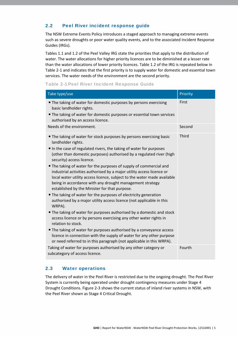
The NSW Extreme Events Policy introduces a staged approach to managing extreme events such as severe droughts or poor water quality events, and to the associated Incident Response Guides (IRGs).
Tables 1.1 and 1.2 of the Peel Valley IRG state the priorities that apply to the distribution of water. The water allocations for higher priority licences are to be diminished at a lesser rate than the water allocations of lower priority licences. Table 1.2 of the IRG is repeated below in Table 2-1 and indicates that the first priority is to supply water for domestic and essential town services. The water needs of the environment are the second priority.
Table 2-1 Peel River Incident Response Guide
Take type/use Priority
The taking of water for domestic purposes by persons exercising basic landholder rights.
The taking of water for domestic purposes or essential town services authorised by an access licence.
First
Needs of the environment. Second
The taking of water for stock purposes by persons exercising basic landholder rights.
In the case of regulated rivers, the taking of water for purposes (other than domestic purposes) authorised by a regulated river (high security) access licence.
The taking of water for the purposes of supply of commercial and industrial activities authorised by a major utility access licence or local water utility access licence, subject to the water made available being in accordance with any drought management strategy established by the Minister for that purpose.
The taking of water for the purposes of electricity generation authorised by a major utility access licence (not applicable in this WRPA).
The taking of water for purposes authorised by a domestic and stock access licence or by persons exercising any other water rights in relation to stock.
The taking of water for purposes authorised by a conveyance access licence in connection with the supply of water for any other purpose or need referred to in this paragraph (not applicable in this WRPA).
Third
Taking of water for purposes authorised by any other category or subcategory of access licence.
Fourth
2.3 Water operations
The delivery of water in the Peel River is restricted due to the ongoing drought. The Peel River System is currently being operated under drought contingency measures under Stage 4 Drought Conditions. Figure 2-3 shows the current status of inland river systems in NSW, with the Peel River shown as Stage 4 Critical Drought.

GHD | Report for WaterNSW - WaterNSW Peel River Drought Protection Works, 12510491 | 6
Source: NSW Department of Planning, Industry and Environment website
Figure 2-3 Map of criticality levels of NSW inland river systems
2.4 Water security options
WaterNSW, local water utilities (Councils) and the NSW Department of Planning, Industry and Environment (DPIE) are jointly and individually planning to implement a range of projects and actions secure water supplies across NSW.
The Peel River is operating under Stage 4 drought conditions and Table 2-2 summarises factors that are considered when determining the criticality of an event. Measures to improve water security have been developed in response to worsening conditions. These include:
The July 2019 Available Water Determination indicates that no allocation has been made for general security licence holders.
The July 2019 Available Water Determination indicates that there are reduced allocations for high priority (town and domestic and stock) and for high security users.
Supply below Dungowan would be restricted by the proposal in late 2019 if dry conditions continue.
The NSW Extreme Events Policy introduces a staged approach to managing extreme events such as severe droughts or poor water quality events.

GHD | Report for WaterNSW - WaterNSW Peel River Drought Protection Works, 12510491 | 7
Table 2-2 Determining the stage of criticality for water quantity extreme events
2.5 Alternatives and options considered
2.5.1 Do nothing option
The do-nothing option would involve not implementing the proposal and continuing to allow water transmission losses in the Peel River between Chaffey Dam and Tamworth. The effects of adopting the do nothing approach would be severe for the city of Tamworth and for the environment. Water storage would be exhausted from Chaffey Dam, and WaterNSW would no longer be able to release water from the dam to supply water to downstream areas including Tamworth.
Under the 'do-nothing' option, the water supply in Chaffey Dam would be depleted by June 2020 in the absence of rainfall. The Peel River would cease to flow downstream of Chaffey Dam in the absence of dam releases and downstream tributary inflows. The proposal would maintain flows between Chaffey Dam and Dungowan and prevent a complete cease to flow

GHD | Report for WaterNSW - WaterNSW Peel River Drought Protection Works, 12510491 | 8
scenario by providing limited pulse flows between Dungowan and Tamworth. The proposal will also allow tributary flows received from Dungowan Ck to pass over the temporary weir.

GHD | Report for WaterNSW - WaterNSW Peel River Drought Protection Works, 12510491 | 9
Water supply impacts
Figure 2-4 shows the predicted timeframes for a cease to flow event for the do-nothing option, and a comparison to the Stage 1 and Stage 2 works.
Without inflows to Chaffey Dam, the Peel River would cease to flow downstream of the dam in June 2020 in the absence of any tributary flows. Under current climatic conditions, the flows within the Peel River are being maintained through releases made from Chaffey Dam. The two major tributaries of the Peel between Chaffey Dam and Tamworth, Dungowan Ck and Cockburn River, have already ceased to flow in the absence rainfall.
A cease to flow event would affect the full length of the river downstream of Chaffey Dam. Water would not be able to be delivered to meet the critical human water needs of Tamworth. Under the do-nothing option, WaterNSW would not be able to supply water to Tamworth beyond June 2020.
If inflows after August 2019 are consistent with those received over the past two years and , the Peel River would cease to flow downstream of the dam in October 2020. If inflows are equivalent to the drought of record, the Peel River would cease to flow in February 2021.
Figure 2-4 shows the impact of the two stages of proposed works. Stage 1 would delay the cease to flow event by seven months, from June 2020 until January 2021 based on zero inflows. Stage 2 would further delay the cease to flow event until July 2021 based on zero inflows. Notably, the Stage 1 works would prevent a cease to flow event even under drought of record inflows, or inflows equivalent to those received over the last two years.
Figure 2-4 Cease to flow timeframes
Environmental impacts of a cease to flow event
Effects on the environment may include threatening the viability of threatened species, including fish, frogs and vegetation communities. As water levels decline, the river would
GHD | Report for WaterNSW - WaterNSW Peel River Drought Protection Works, 12510491 | 10
revert to a series of pools that provide refuge habitat for aquatic biota. The extent and quality of aquatic habitat would progressively decline as the size of these pools diminishes due to evaporation, infiltration and extraction for human needs. This would affect the full length of the Peel River downstream of Chaffey Dam.
Diminished water flows have the potential to result in water quality impacts such as stratification, eutrophication and fish kills. Cease to flow would also diminish habitat resources for threatened species such as the Booroolong Frog. A cease to flow event would have the potential to result in impacts that include:
Complete loss of flowing water habitat from downstream of Chaffey Dam. This is the preferred habitat for the threatened Eel-tailed catfish, the Purple Spotted Gudgeon and the Silver Perch in the Namoi System.
Increased fish biomass in dwindling pools would lead to an increase in nutrients. This combined with still water, due to the lack of flow, would lead to cyanobacterial domination of the algal community. High cyanobacterial numbers in still water would create an anoxic layer reducing oxygen levels for the remaining fish. This is likely to result in large scale fish kills of all species with the larger species dying first, as happened during January 2019 at the Darling River near Menindee Lakes. The decaying fish carcases would release nutrients, causing an increase in the algal biomass and increasing oxygen demand on the pools at night and likely cause the death of the remaining fish.
Depending on the how hot this summer is, the remaining refuge would have ideal conditions for cyanobacterial blooms and could result in the loss of Murray Cod, Eeltailed Catfish, the Purple Spotted Gudgeon and the Silver Perch and other native fish species along the Peel River, Namoi River and tributaries.
Shallow refuge pools too shallow to stratify would likely dry out over the summer with all fish trapped dying.
2.5.2 Water carting
Carting water to a city the size of Tamworth and its surrounds, with a population of nearly 60,000 people, is not feasible. A water source would need to be located within driving range, and be abundant enough to supply the volumes required.
Based on a daily water demand of 22 ML, on average 880 water truck movements would be required each day, assuming that each truck can carry 25,000 litres. At a conservative cost estimate of $500 per truck delivery, water carting would cost $440,000 per day or $13.2M per month. Using rail to cart water to Tamworth would be similarly expensive and would not be feasible.
2.5.3 Groundwater
Use of groundwater as an alternative drinking water source for Tamworth is not feasible. Tamworth Regional Council has undertaken groundwater investigations and determined that there are no feasible groundwater sources. Further details are provided in section 6.1.
2.5.4 Evacuation
If the do-nothing approach is adopted, and there is no rainfall to replenish bulk storage supplies, the decision to evacuate Tamworth would need to be considered. As the June 2020 cease to flow event approaches, water supplies could not be guaranteed. This would leave Tamworth and its residents vulnerable to severe water shortages, and threaten the viability of the city.
GHD | Report for WaterNSW - WaterNSW Peel River Drought Protection Works, 12510491 | 11
2.6 Staged implementation of the proposal
WaterNSW has developed a drought response strategy that is to be delivered in two stages. The staged approach would allow Tamworth’s water security to be improved at the earliest possible time, and the water supply secured for the medium to long-term.
Stage 1 (the proposal), the subject of this REF, is to be operational by 30 November 2019. Stage 1 works are temporary and required for a period of at least six months until the pipeline from Chaffey Dam to the Dungowan pipeline is available in Stage 2. Stage 2 is planned to be operational by February 2020.
Under the zero inflow scenario, Stage 1 works would defer the cease to flow event until January 2021 (from June 2020). If flows equivalent to the worst drought on record are received, Stage 1 works would prevent the cease to flow event.
The Stage 2 Chaffey to Dungowan pipeline works would provide for the immediate, and long-term water security for Tamworth. The improved efficiencies provided by the Chaffey Dam to Dungowan pipeline would eliminate the significant transfer water losses recorded annually by transfers down the Peel River. This would have flow on positive benefits for the long-term management of water in the Peel River system.
2.7 Justification of the preferred option
The proposal is the preferred option for short-term water management in the Peel River to secure water for the city of Tamworth. If the do-nothing approach is adopted and the proposal does not proceed, water supplies to Tamworth would not be available from June 2020 in the absence of inflows into Chaffey Dam from rainfall.
The proposal would slow the depletion of Tamworth’s water supply in Chaffey Dam by reducing transmission losses in the Peel River, and allow water to remain in the Peel River between Chaffey Dam and Dungowan. This section of the Peel River provides habitat for aquatic and terrestrial flora and fauna species. Further details are provided in section 6.4.
Carting water into Tamworth via trucks or rail would not be a feasible or economic option. Groundwater resources in the Tamworth area are not sufficient to provide an alternative supply. The proposal is justified as the most economic, time effective and efficient manner to secure water supplies to Tamworth. If the proposal does not proceed, water supplies for critical human needs in Tamworth could not be reliably provided beyond June 2020 in the absence of sufficient rainfall.
Details of the proposal’s location, objectives and design are provided in section 3.

GHD | Report for WaterNSW - WaterNSW Peel River Drought Protection Works, 12510491 | 12
3. Description of the Proposal 3.1 Proposal location
The Tamworth drought response work is being delivered in two stages. This REF assesses the potential impacts of the construction and operation of the Stage 1 works only. A separate REF has been prepared for the Stage 2 works.
The Stage 1 works include installing a temporary weir and water intake structure in the Peel River at Dungowan, north-west of the Dungowan Recreation Ground. Dungowan Recreation Ground is located on Duri-Dungowan Road (Lot 63 DP 755329). The proposal is located on land owned by Tamworth Regional Council. The Dungowan site is shown in Figure 3-1.

ÍB
Dungowanproject location
CHAFFEY DAMWATER SUPPLY
RESERVE
GOONOO GOONO O CREEK
PE EL RIVERREED Y CREEK
DUNGOW ANCREEK
LAMB
RUK CR
EEK
BO ILING DO WN CREEK
MI DDLEBROO
K CREEK
SANDYCREEK
SPRIN G CREEK
MULLAMULLA
CREEK
COC KBURN RIVER
TI MBU
MBUR
ICRE
EK
WOOLOMIN
DUNGOWAN
PIALLAMORE
NEMINGHA
TAMWORTH
CALALA
FIGURE 3-1
0 1 2 3 4 5
Kilometers
Project No.Revision No. 0
12510491Date 15 Oct 2019
Water NSWPeel Drought Temporary Works and
Chaffey Dam PipelineReview of Environmental Factors - Stage 1
Map Projection: Transverse MercatorHorizontal Datum: GDA 1994Grid: GDA 1994 MGA Zone 56
Paper Size ISO A4
oData source: Commonwealth of Australia (Geoscience Australia): 250K Topographic Data Series 3, 2006. . Created by: tmorton, TMortonG:\22\12509994\GIS\Maps\Deliverables\REF\Stage1\12509994_REF_S100_RegionalLocality_0.mxd
Print date: 15 Oct 2019 - 09:29
LegendDPL transfer pipe - Option 1
DPL pipeline
Built up area
Recreation area
Reserve
Watercourse
Native vegetation area
Reservoir
Locality map

GHD | Report for WaterNSW - WaterNSW Peel River Drought Protection Works, 12510491 | 14
3.2 Proposal objectives
The objective of the proposal is to extract water from the Peel River at Dungowan and transfer it to the Calala WTP via the existing Dungowan Dam to Calala WTP pipeline. The proposal would reduce the transmission losses that occur along the Peel River between Chaffey Dam and Calala WTP. The proposal would be temporary and is proposed to be in place for between six and 12 months. The Stage 1 works would be in place until the Stage 2 pipeline commences operation.
Tamworth Regional Council (TRC) may still extract water from the Peel River at the Calala WTP site in the event of a failure in the proposal’s temporary transfer pipeline, and if there is sufficient water present. The ability to extract water from the Peel River at Calala would depend on the flows available in the Peel River downstream of Dungowan, and the contribution of tributary flows. Operational plans for the Calala WTP would be confirmed in consultation with TRC at the detailed design and operation stages.
3.3 Proposal description
The proposal would be temporary and would include a weir, water intake structure and a transfer pipeline at Dungowan. The Dungowan water intake has been designed to a capacity of 22 ML/day.
3.3.1 Dungowan water intake
The water intake would be constructed into the southern bank of the river, in the location of an existing 4WD crossing. The weir would provide a pool of water around a screened suction intake.
The water intake would be constructed using a precast concrete intake pit excavated into the existing river bank. The structure would then be backfilled with single size aggregate. This is shown in Figure 3-2. Rock beaching would be installed to stabilise the surface. A rip-rap apron would then be placed around the intake. The dashed line shows the natural ground surface level of the southern river bank.
Figure 3-2 Dungowan water intake

GHD | Report for WaterNSW - WaterNSW Peel River Drought Protection Works, 12510491 | 15
The water intake structure would sit upstream of the temporary weir. Water releases from Chaffey Dam would be managed so that the required amount, usually 22 ML, would be captured by the temporary weir and the intake pit would fill with water. This water would be extracted by the pump station. Environmental flows (see sections 3.9 and 6.1.4) would flow over the temporary weir and downstream.
The intake would consist of:
A precast concrete pit two metres long, two metres wide and 1.6 metres high with a cut out section to fit the 500 mm diameter HDPE suction pipeline
A prefabricated grate bolted to the top to allow water into the pit
A screened fabricated stainless suction intake, with 3 mm aperture on the screen, to reduce the risk of aquatic biota including fish and larvae being drawn into the intake
A water level sensor in the intake pit to monitor water levels
An apron of rip-rap (d50-150 mm) to provide scour protection
3.3.2 Dungowan temporary weir
The temporary weir would be constructed using nine precast concrete box culverts installed in a line across the river at the existing 4WD crossing. Each box culvert would be approximately two metres square and 1.4 metres high. The temporary weir would include an overflow section in the middle section of the river, between 100 mm and 300 mm below the top of the weir. This invert would allow environmental water releases and tributary flows to pass downstream and provide water connectivity. Scour protection would be installed on the downstream side of the weir, made of gabion or rip rap. This would be designed to minimise scour and water quality impacts.
The concrete box culverts would be installed on a concrete slurry base for stability. This would require the river to be temporarily blocked using aqua bags to install the concrete box culverts. Each culvert would be filled with rock for stability.
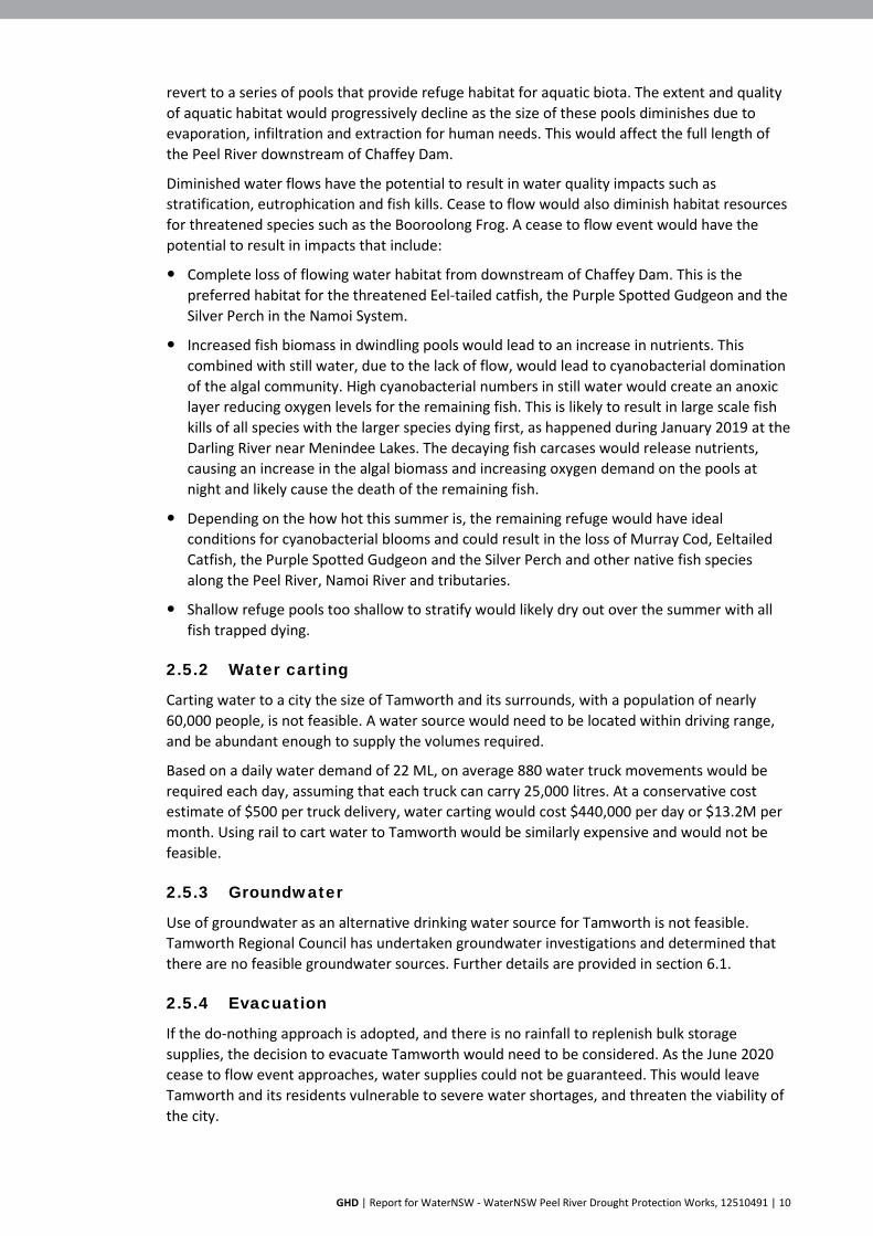
This temporary weir has been designed to allow water from environmental releases and tributary flows from Dungowan Creek to pass over the weir and continue downstream. Flow releases from Chaffey Dam would be managed to allow the environmental flows to pass over the top and downstream (see sections 3.9 and 6.1.4). Scour protection would be provided downstream of the temporary weir to minimise impacts on water quality. The layout of the temporary weir is show in Figure 3-3.
GHD | Report for WaterNSW - WaterNSW Peel River Drought Protection Works, 12510491 | 16
Figure 3-3 Temporary weir
3.3.3 Dungowan transfer pipeline
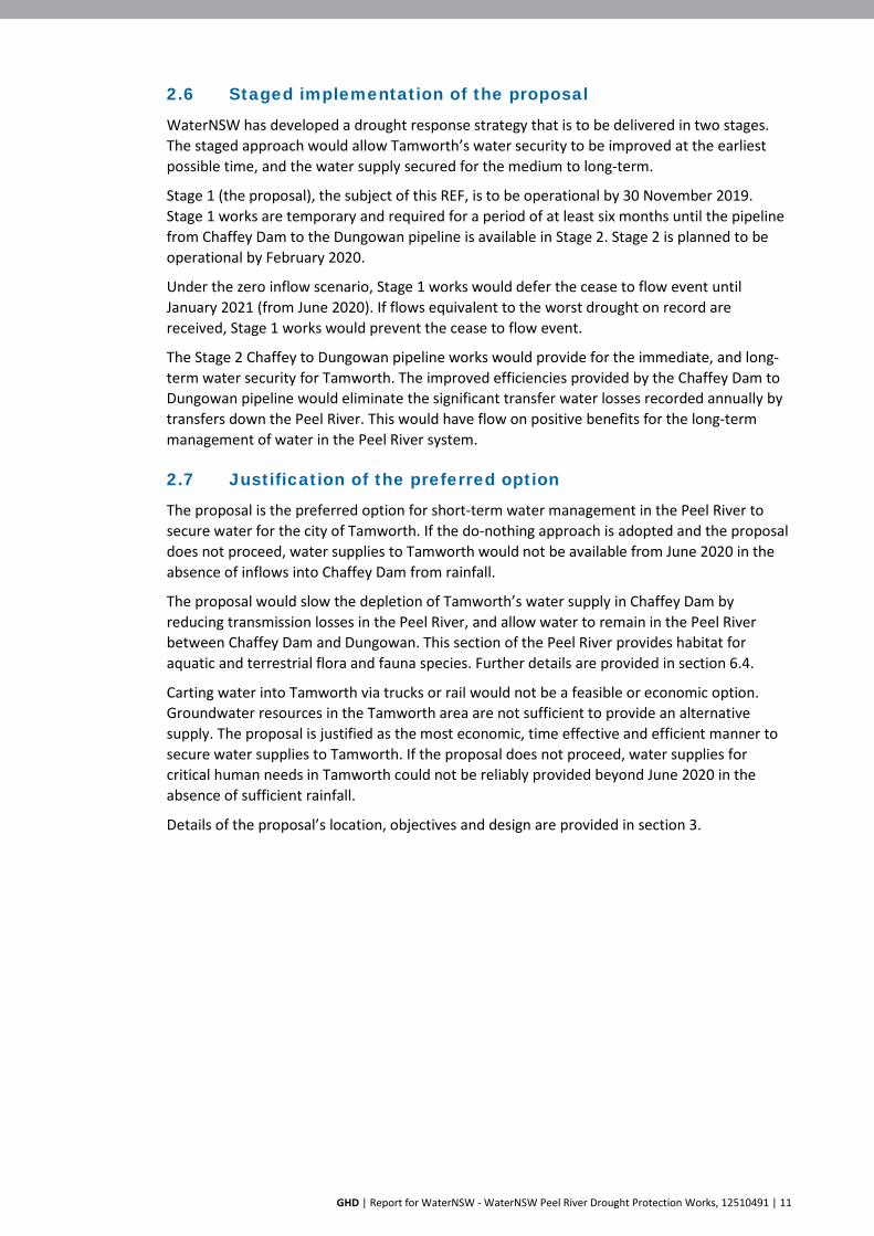
Water would be pumped from the water intake via self-priming diesel pumps and a 570 metre long transfer pipeline to connect to the existing Dungowan pipeline. The transfer pipeline would be High Density Polyethylene (HDPE) with an external diameter of 500 mm. This temporary pipeline would be installed above ground, with in-line anchors at the water intake and connection point with the Dungowan pipeline. Trenching or directional boring would be required to cross Duri-Dungowan Road. The location of the water intake structure, and the route for the temporary transfer pipeline at Dungowan are shown in Figure 3-4.
3.3.4 Pumps
The pump design has been modelled as a single installation, comprised of three pumps. Two would be duty pumps, with the third pump on standby. The diesel pumps would be supplied via a 26,000 L bunded diesel storage tank. The pumps are capable of ramping up and down on start-up and stop over. The pumps would be located on an excavated flat area approximately 20 metres from the river.

GHD | Report for WaterNSW - WaterNSW Peel River Drought Protection Works, 12510491 | 17
Figure 3-4 Dungowan transfer pipeline route

GHD | Report for WaterNSW - WaterNSW Peel River Drought Protection Works, 12510491 | 18
3.4 Construction activities
Table 3-1 summarises the proposed construction activities for the Stage 1 works.
Table 3-1 Construction
Site Proposed works Construction methodology Dungowan
Existing 4WD crossing and location of the Dungowan structure
The proposed works at the Dungowan site involve: Installing the temporary water intake
structure in the riverbank at the existing 4WD crossing. The intake would be fitted with a screen with a 3 mm diameter aperture to minimise the risk of impact on aquatic organisms.
Constructing the temporary weir by placing precast concrete box culverts in a line across the river immediately downstream of the existing 4WD crossing to allow water to pool.
Construction would involve: Excavating an area about five metres by five metres in
the river bank, to a depth of 1.5 metres within the existing 4WD crossing
Installing the precast concrete pit within the river bank
Installing the screened suction intake and water level sensors
Trenching to install a 500 mm diameter polyethylene pipe to connect the water intake structure with the pump station
Backfilling excavations and placing an apron of rip-rap on top of excavated areas to stabilise the soil
Temporarily blocking the river with aqua bags to place concrete slurry as a bed for the temporary weir
Placing the prefabricated concrete culverts in a line across the river immediately downstream of the existing 4WD crossing
The temporary weir would include an overflow section in the middle section of the river, between 100 mm and 300 mm below the top of the weir.
Scour protection would be installed on the downstream side of the weir, made of gabion or rip rap.
Disturbed areas used during construction would be reinstated.

GHD | Report for WaterNSW - WaterNSW Peel River Drought Protection Works, 12510491 | 19
Site Proposed works Construction methodology Temporary transfer pipeline
Source: Google Earth Pro
The temporary transfer pipeline would be HDPE with internal diameter of 450 mm. It would run overland for approximately 550 metres from the river intake to connect with the existing Dungowan pipeline
Construction of the temporary pump station
Three pumps, (2 x duty, 1 x standby) each with variable speed drive motors and a capacity of 11 ML/day, are to be installed adjacent to the water intake
Construction of a diesel storage area with a 26,000 litre tank
Construction of a bund area with a design capacity of 110% of the fuel storage capacity
Bunding would be constructed in accordance with Australian Standard AS 1940B1993: The Storage and Handling of Flammable and Combustible Liquids.
Construction would involve: Connecting the HDPE transfer pipeline with the water
intake structure
The HDPE transfer pipeline would be anchored to the ground at each end
Construction of the temporary pump station and bund area would include ground levelling, construction of the bund area
Duri-Dungowan Road would be under-bored or trenched to allow the pipeline to cross
Connecting the temporary pipeline to the DPL
Security fencing would be installed.

GHD | Report for WaterNSW - WaterNSW Peel River Drought Protection Works, 12510491 | 20
3.5 Construction equipment
The detailed design and construction contractor would select the construction plant and equipment to undertake the works. Examples of typical equipment likely to be used in construction include the following:
All terrain crane – 100 tonne
Excavator – 30 tonne
Crane truck
10 cubic metre capacity tip truck
Concrete boom pump
Trailer mounted air compressor
Trailer mounted generator
Large rigid tray truck
Pipe laying and welding equipment
Fuel bunding
3.6 Construction compounds
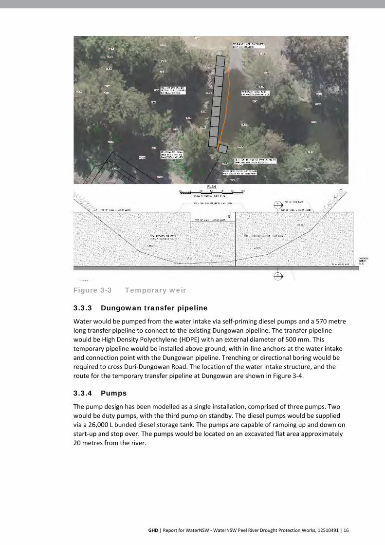
A temporary construction compound would be required to prepare the site for construction, to complete construction activities, and to decommission the Stage 1 works. A construction compound would be established on cleared land adjacent to the Dungowan Sports Field, near the Duri-Dungowan Road on the southern side of the river. The exact location and dimensions would be determined at the detailed design stage. Figure 3-5 shows the location of the likely construction compound site.
"ª!
DURI-DUNGOWAN ROAD
NUNDLE ROAD
DURI
-DUN
GO
WAN
RO
AD
BACKW
OOLOM
INRO
AD
DUNGOWANRECREATION
GROUND
FIGURE 3-5
0 20 40 60 80 100 120
Meters
Project No.Revision No. 0
12510491Date 15 Oct 2019
Water NSWPeel Drought Temporary Works and
Chaffey Dam PipelineReview of Environmental Factors - Stage 1
Map Projection: Transverse MercatorHorizontal Datum: GDA 1994Grid: GDA 1994 MGA Zone 56
Paper Size ISO A4
oData source: LPI:CDB?DTDB, 2017. Water NSW: Elevation\Heritage data, 2019. DBYD: Tesltra data, 2019. © Department of Finance, Services & Innovation 2017. Created by: tmorton, TMortonG:\22\12509994\GIS\Maps\Deliverables\REF\Stage1\12509994_REF_S102_DungowanConstructionCompound_0.mxd
Print date: 15 Oct 2019 - 09:28
LegendDPL transfer pipe - Option 1
DPL
"ª! Pump
Indicative compound location
Construction compound
ÍB
WOOLOMIN
DUNGOWAN
CHAFFEY DAM
Regional locality

GHD | Report for WaterNSW - WaterNSW Peel River Drought Protection Works, 12510491 | 22
3.7 Site access
Works at the Dungowan site would require use of Nundle Road, Duri-Dungowan Road and potentially the New England Highway. WaterNSW would consult with landholders if access to private property is required.
3.8 Work hours
Stage 1 of the proposal is required to be installed and operational by 30 November 2019. Construction and commissioning is expected to take about three weeks.
The following standard working hours defined in the Environmental Protection Authority’s (EPA) Interim Construction Noise Guidelines 2009 (ICNG):
Monday to Friday: 7:00 am to 6:00 pm
Saturday: 8:00 am to 1:00 pm
Sunday and Public Holidays: No work
Given the criticality of the works, construction would be required outside these standard hours. This would involve working on Saturday and Sunday from 8:00 am to 4:00 pm. The ICNG indicates that work may be undertaken outside the standard construction hours under certain circumstances, including:
If it involves public infrastructure works
The extended hours will shorten the length of the project
If the works are supported by the affected community
Work would only occur outside the nominated working hours for the following reasons, and subject to prior approval by WaterNSW:
The delivery of oversized plant or structures that police or other authorities determine require special arrangements to transport along public roads
Emergency work to avoid the loss of life or damage to property, or to prevent environmental harm
Maintenance and repair of public infrastructure where disruption to essential services and/or considerations of worker safety do not allow work within standard hours
Public infrastructure works that shorten the length of the project and are supported by the affected community
Works where a proponent demonstrates and justifies a need to operate outside the recommended standard hours
WaterNSW would consult with affected stakeholders regarding the extended working hours.
3.9 Operation
3.9.1 Overview
The proposal would be operated by WaterNSW for a period of about six to 12 months. Water flow and allocation priorities would be managed to prioritise critical human need, and in consultation with the NSW Department of Primary Industries - Fisheries (DPIF) and DPIE.
High security water users downstream of Dungowan have been consulted. WaterNSW would work with these users to assist in securing alternative water sources during the operation of the proposal.

GHD | Report for WaterNSW - WaterNSW Peel River Drought Protection Works, 12510491 | 23
3.9.2 Monitoring
The proposal would be operated by WaterNSW in accordance with procedures that apply to the remainder of its water supply network, including arrangements to implement temporary works during droughts. Specific measures would be developed in consultation with DPIE and DPIF and relate to monitoring water quality. The monitoring program is intended to enable a real-time risk assessment to be undertaken based on the best available evidence of water quality conditions.
The monitoring program would identify key sites to be monitored and prioritise actions to minimise the risk of adverse impacts and maximise potential benefits. This would involve identifying locations where specific measures are to be implemented, such as deploying aerators, to reduce the risk of poor water quality conditions developing. The extent of monitoring would be determined by WaterNSW in consultation with DPIE and DPIF. The monitoring activities would involve regular consultation with the DPIF including the Namoi – Peel Valley Technical Advisory Group.
The monitoring program would be implemented to manage impacts associated with the temporary works. It would not be a long-term program and would be discontinued once the proposal is decommissioned.
3.9.3 Water releases
Water allocations under the Peel Regulated River Water Source are made in accordance with Water Sharing Plans (WSP). The WSP includes environmental licences and allowances. Water allocations are only made on an annual basis and there is no carryover of water allocations into the following water year. Resource assessments are carried out on a monthly basis, and if conditions permit general security allocations increase throughout the year (if not already at 100%).
Under normal operating conditions, TRC requires water from Chaffey Dam daily as the primary water source. TRC uses Dungowan Dam as a backup water supply. When Dungowan Dam drops below 50% capacity, TRC only sources water from Dungowan on an “as-needed” basis. These circumstances include times when there are reliability issues with supplies from Chaffey Dam via the Peel River, or when demand increases significantly. TRC also uses storage in Dungowan Dam as a risk mitigation in the event that the Chaffey Dam and Peel River water source becomes unavailable.
Water is released from Chaffey Dam after a customer’s order is received (for example TRC). Water flows down the Peel River to the customer’s site, where it is extracted. Depending on the customer’s location, this transmission can take up to six days to reach the customer site after release from Chaffey Dam.
As part of the drought management response, the proposal would shorten the distance the water would need to travel along the Peel River before extraction into the raw water pipeline to Calala WTP. Water would be extracted at the temporary Dungowan water intake and then transferred to the existing Dungowan Pipeline. TRC’s water deliveries would be made to the Dungowan water intake, instead of travelling the length of the Peel River from Chaffey Dam to Calala WTP. This would significantly reduce water transmission losses. The volumes released from Chaffey Dam would be matched with TRC requirements for potable water to Tamworth.
GHD | Report for WaterNSW - WaterNSW Peel River Drought Protection Works, 12510491 | 24
Environmental pulse flows are proposed from Chaffey Dam and pass downstream of the Dungowan intake. These flows are proposed as weekly releases of up to 30 ML from Chaffey Dam and notionally released over one day each week or less frequently while water quality remains stable. The volumes and frequency of these releases could be lower in volume and frequency and would be managed in response to the results of the operational water quality monitoring and tributary inflows. The pulse flows would allow water to remain in the river and to periodically connect key refuge pools identified by DPI Fisheries. The environmental pulse flow is in addition to TRC requirements.
3.9.4 Dungowan water intake
The proposal would allow water to be extracted from the Peel River at Dungowan which is about 20 kilometres upstream of the Calala WTP. This would reduce the significant transmission losses from delivering water from Chaffey Dam to the Calala WTP, while still maintaining water in the river system.
Water released from Chaffey Dam would be co-ordinated with the operation of the pump station at Dungowan. The timing of releases would be matched to the intake volume and pumping capacity at the Dungowan intake for transfer to the existing Dungowan pipeline, and then the Calala WTP. This would allow the existing Dungowan pipeline to operate efficiently and avoid potential operational issues such as pipeline pressure and water hammer effects. Water hammer is an effect where water is forced to stop or change direction suddenly.
The design of the temporary weir and intake structure at Dungowan have been developed to allow some downstream flows to be maintained through releases that top the weir. Operation of the proposal would involve coordinating water releases from Chaffey Dam so that environmental flows are allowed to pass over the temporary weir and travel downstream of Dungowan. This would provide water connectivity between the sections of the Peel River downstream of the temporary weir.
3.9.5 Pump station
The Stage 1 pumps would be operated based on the water level of Break Tank 2 (BT2). BT2 is downstream of Dungowan on the existing Dungowan pipeline, northwest of the intersection of Loomberah Road and Tullamore Road. The water level of BT2 is controlled by a control valve (CV2), which opens and closes to maintain the water level of 6.4 m in BT2.
When volumes in the existing Dungowan pipeline are unable to meet the minimum water levels in BT2, the Stage 1 pump station would cut in to deliver water to BT2. The Stage 1 pumps are designed to be fitted with non-return valves to prevent backflows into the river when the pumps are not operating.
The Stage 1 pumps would transfer up to 22 ML/d to BT2, provided there is sufficient water in the river at Dungowan. This matches the rated capacity of the existing Dungowan pipeline.
Diesel pumps have been selected as the existing electricity network supply at the site is not sufficient to meet the power demands for the pumps. The electrical network cannot be upgraded in time to enable the Stage 1 works to be operating by 30 November 2019. The temporary pump station would be located on flat ground in a bunded area approximately 20 metres from the river, above the level of the top of the weir.
The pumps would require about 3,200 litres of diesel every day. An on-site fuel storage tank with a capacity of 26,000 litres would be required at the pump station site. This would provide diesel for up to eight days’ of pump operation. Refuelling of the storage tank would occur as required.

GHD | Report for WaterNSW - WaterNSW Peel River Drought Protection Works, 12510491 | 25
3.10 Decommissioning
The proposal is approved under ISEPP cl 129 (3) which enables temporary works for, or associated with, drought relief to be undertaken. The proposed temporary structures would remain in place until the Stage 2 permanent pipeline is commissioned or drought conditions ease. Decommissioning the temporary structures at Dungowan would be done in consultation with relevant agencies including the Critical Water Advisory Panel.
3.11 Timing
The Stage 1 works are to be installed and operational by 30 November 2019 and are expected to operate until Stage 2 is operational or drought conditions cease.
GHD | Report for WaterNSW - WaterNSW Peel River Drought Protection Works, 12510491 | 26
4. Statutory and planning framework 4.1 NSW Environmental Planning and Assessment Act 1979
All development in NSW is assessed in accordance with the provisions of the Environmental Planning and Assessment Act 1979 (EP&A Act) and Environmental Planning and Assessment Regulation 2000 (EP&A Regulation). The EP&A Act is the principal planning legislation in NSW and provides the framework for environmental planning and assessment. Implementation of the EP&A Act is the responsibility of the Minister for Planning, statutory authorities and local councils.
The proposal does not require development consent under Part 4 of the EP&A Act. The proposal is an activity that requires assessment under Part 5 of the EP&A Act. Section 5.5 of the EP&A Act outlines the duty of determining authorities to consider the environmental impacts of an ‘activity’. When considering an activity, the determining authority is required to ‘examine and take into account to the fullest extent possible all matters affecting or likely to affect the environment’.
Section 5.7 of the EP&A Act requires the determining authority to consider whether an activity is ‘likely to significantly affect the environment’ (including critical habitat) or threatened species, populations or ecological communities, or their habitats. If a determining authority is of the opinion that an activity would be likely to significantly affect the environment, by virtue of a Ministerial order, the activity would then require the approval of the Minister for Planning. Factors that need to be taken into account when considering the likely impact of an activity on the environment are outlined in Clause 228 of the EP&A Regulation. A review of the proposal against Clause 228 is found in section 8.3.
Section 6 of this REF assesses the likely effect of the proposal on the environment. As the proposal is unlikely to result in significant impacts, an environmental impact statement is not required. A REF has been prepared to assess the environmental impacts to satisfy the requirements of Part 5 of the EP&A Act.
WaterNSW as the proponent is also the determining authority for the proposal.
4.1.1 Environmental planning instruments
State Environmental Planning Policy (Infrastructure)
The State Environmental Planning Policy (Infrastructure) (ISEPP) aims to facilitate the effective delivery of infrastructure across the state. It facilitates increased regulatory certainty and improved efficiency and flexibility in the location of infrastructure and service facilities, while providing for adequate stakeholder consultation.
ISEPP relates primarily to public infrastructure projects developed for or on behalf of public authorities. Division 25 of Part 3 of ISEPP relates to waterway or foreshore management activities. In accordance with Clause 129 (3):
Development for the purpose of temporary works for or associated with drought relief may be carried out by or on behalf of a public authority without consent, but only if the development is:
a. carried out on land publicly identified by the Minister for Primary Industries as being in drought, and
b. removed, and the area rehabilitated, within 4 months after the date on which the area is no longer so identified.

GHD | Report for WaterNSW - WaterNSW Peel River Drought Protection Works, 12510491 | 27
The Department of Primary Industries website (accessed 30/07/2019) identifies the Tamworth Regional Council area ranges between areas in ‘intense drought’, ‘in drought’, and ‘drought affected’.
As the proposal is a temporary work associated with drought relief and would be on land that the Minister has declared to be in drought, it does not require consent and is subject to assessment Part 5 of the EP&A Act. WaterNSW would be the proponent and determining authority for the REF in accordance with Section 5.2 of the EP&A Act.
Consultation
Clauses 13, 14, 15 and 16 of the ISEPP require public authorities to undertake consultation with councils and other agencies in certain circumstances when proposing to carry out development without consent. The proposal site is not located on land identified in TRC’s Flood Planning Map. The proposal would involve works in an area liable to flooding as it is located within the Peel River. The proposal is temporary and would not cause significant flooding impacts as it would be constructed and operated during drought. Consultation with TRC is not required under Clause 15 of ISEPP, however WaterNSW has consulted with Tamworth Regional Council throughout the development of the proposal.
State Environmental Planning Policy (State and Regional Development) 2011
State Environmental Planning Policy (State and Regional Development) 2011 (SRD SEPP) was reviewed to determine whether the proposal requires approval under Part 5.1 of the EP&A Act. The proposal does not meet the criteria for State significant development under Clause 8(1)(a) of the SRD SEPP because it is permissible without development consent under Part 4 of the EP&A Act due to the application of Clause 129(3) of Infrastructure SEPP.
Under Clause 14(1) of the SRD SEPP, development is declared State significant infrastructure if:
(a) the development on the land concerned is, by the operation of a State environmental planning policy, permissible without development consent under Part 4 of the Act, and
(b) the development is specified in Schedule 3.
Clause 1 of Schedule 3 of the SRD SEPP relates to:
Infrastructure or other development that (but for Part 5.1 of the Act and within the meaning of Part 5 of the Act) would be an activity for which the proponent is also the determining authority and would, in the opinion of the proponent, require an environmental impact statement to be obtained under Part 5 of the Act.
The proposal would not require an EIS under Part 5 of the EP&A Act as it is unlikely to result in significant environmental impacts. As the proposal is not of a type specified in Schedule 3, it is not State significant infrastructure and does not require approval under Part 5.1 of the EP&A Act.
Tamworth Regional Local Environmental Plan 2010
Land use within the Tamworth local government area is regulated by the Tamworth Local Environmental Plan 2010 (LEP). The proposal does not require development consent under the LEP due to the application of clauses 1.9 and 5.12 of the LEP, and clause 129(3) of State Environmental Planning Policy (Infrastructure) 2007.
The proposal would be located on land that is zoned for RU1 – Primary Production under the LEP. The proposal site is not located within a flood planning area.

GHD | Report for WaterNSW - WaterNSW Peel River Drought Protection Works, 12510491 | 28
4.2 NSW legislation
4.2.1 Water Management Act 2000
The Water Management Act 2000 (WM Act) is the primary piece of legislation established to provide sustainable and integrated management of water in NSW. The Water Management Act 2000 (WM Act) governs the sustainable and integrated management of the State’s water for the benefit of both present and future generations. Under the WM Act, a Water Supply Work Approval (WSWA) is required to use a specified water supply work at a specified location.
Clause 39A of the Water Management (General) Regulation 2018 enables the Minister administering the WM Act to grant an exemption from approvals under section 91B(1) of the Act if the Minister is satisfied that the conditions of drought exist and the granting the exemption is in the public interest. The proposal is in the public interest as it is a temporary drought response to extend Tamworth’s water supply. WaterNSW applied for and received an exemption from the need for a water supply works approval pursuant to Clause 39A of the Water Management (General) Regulation 2018, reference number 90MW833040.
WaterNSW and DPI have contacted downstream water users. These include farmers and other landholders reliant on water from Peel River. Consultation would continue as the impacts of the drought are being managed and water allocations are determined.
4.2.2 Water NSW Act 2014
Under Section 32 of the Water NSW Act 2014, Water NSW is permitted to enter and occupy land for the construction of new works and to carry out the work on, below or above the surface of the land and to repair, replace, maintain, remove, extend or improve any of its systems for the purposes of carrying out the terms and conditions of its operating licences.
Where the works are to be undertaken or access is required on private land, the landowner has been consulted regarding the proposed works and an access agreement has been negotiated and agreed to by the land owner.
4.2.3 Water Sharing Plan for the Peel Valley Regulated, Unregulated, Alluvium and Fractured Rock Water Sources 2010
The Peel Valley Regulated, Unregulated, Alluvium and Fractured Rock Water Sources 2010 (WSP) covers the sections of the Peel River where the proposal would be undertaken. The WSP sets the rules for the management of water access licences, water allocation accounts, the extraction of water, the operation of dams and the management of environmental water flows.
Section 2.4 reflects that under a Stage 4 critical drought/water shortage, the WSP may be partially suspended as part of measures to manage water supplies. The Peel Valley WSP has not been suspended to date.
4.2.4 Fisheries Management Act 1994
The Fisheries Management Act 1994 (FM Act) provides for the sustainable management of fish and fish habitats and outlines approval processes for the activities that may impact on threatened fish species and habitats.
The Minister for Fisheries is required to be notified under section 199 of the FM Act of any proposed dredging and reclamation works in ‘waterland’ undertaken by a public authority (other than a Council). The proposal involves work within a waterway to install a water intake

GHD | Report for WaterNSW - WaterNSW Peel River Drought Protection Works, 12510491 | 29
at Dungowan. This meets the definition of dredging and reclamation. WaterNSW is required to notify DPIF and consider any matters raised by DPIF within 21 days of the notice being given.
Under Section 218 (5) A public authority that proposes to construct, alter or modify a dam, weir or reservoir on a waterway (or to approve of any such construction, alteration or modification):
(a) Must notify the Minister of the proposal, and
(b) Must, if the Minister so requests, include as part of the works for the dam, weir or reservoir, or for its alteration or modification, a suitable fishway or fish by-pass.
Under Section 219 of the FM Act it is an offence to block the passage of fish. The FM Act requires a person who “constructs or alters a dam, floodgate, causeway or weir” to obtain a permit from the Minister for Primary Industry. The proposal involves the construction of a temporary weir. Water connectivity between upstream and downstream sections of the river either side of the temporary weir would be maintained by environmental releases that top the weir. WaterNSW will seek a permit from DPI Fisheries under section 219 of the FM Act prior to construction.
4.2.5 Biodiversity Conservation Act 2016
The Biodiversity Conservation Act 2016 (BC Act) provides legal status for biota of conservation significance in NSW. The BC Act aims to, amongst other things, ‘maintain a healthy, productive and resilient environment for the greatest well-being of the community, now and into the future, consistent with the principles of ecologically sustainable development’. It provides for the listing of threatened species and communities, establishes a framework to avoid, minimise and offset the impacts of proposed development, and establishes a standard method for assessing the likely impacts on biodiversity values and calculating measures to offset those impacts.
This Act applies in relation to animals and plants and not in relation to fish and marine vegetation (refer Fisheries Management Act 1994).
Part 7.2 (1) of the BC Act, states that development or an activity is “likely to significantly affect threatened species” if:
It is likely to significantly affect threatened species or ecological communities, or their habitats, according to the test in section 7.3, or
The development exceeds the biodiversity offsets scheme threshold if the biodiversity offsets scheme applies to the impacts of development on biodiversity values, or
It is carried out in a declared area of outstanding biodiversity value.
Potential impacts on threatened species or ecological communities, or their habitats have been considered in section 6.4 and impacts are not considered to be potentially significant.
4.2.6 National Parks and Wildlife Act 1974
The National Parks and Wildlife Act 1974 promotes and regulates the management of national parks and historic sites or places of cultural value within the landscape and the conservation of certain fauna, native plants and Aboriginal objects and places.
The NPW Act provides the basis for legal protection and management of Aboriginal sites in NSW. All Aboriginal objects within the state of New South Wales are protected under Part 6 of the NPW Act. The implementation of the Aboriginal heritage provisions in the NPW Act is the responsibility of the DPIE.
No known Aboriginal sites are to be impacted by the proposal. Design solutions have been adopted to avoid items and areas of known Aboriginal heritage significance. Section 6.2

GHD | Report for WaterNSW - WaterNSW Peel River Drought Protection Works, 12510491 | 30
provides details of the assessment of Aboriginal heritage issues and management. Appendix A contains the Due Diligence Aboriginal Heritage Assessment undertaken for the proposal. No permits are likely to be required under the NPW Act.
4.2.7 Heritage Act 1977
The objects of the NSW Heritage Act 1977 include the conservation of heritage and the identification and registration of items of State heritage significance. The Act is concerned with all aspects of conservation, including protection against damage and destruction, to restoration and enhancement. All historic remains and all potential sub-surface archaeological features are subject to provisions of the Act and are therefore afforded concurrent statutory protection.
4.2.8 Crown Lands Management Act 2016
Works would take place within a waterway which is Crown land. WaterNSW is empowered under s 32(1) (b) & (c) of the Water NSW Act 2014 to ‘enter and occupy land … to operate…to construct new works and, for these purposes, carry out any work below or above the surface’. This provides WaterNSW with ‘lawful authority’ to erect a structure on Crown land without the need for a licence under the Crown Lands Management Act 2016. In accordance with Section 32(5) of the WaterNSW Act 2014, WaterNSW would provide written notice of the intention to enter Crown Land to construct and operate the proposal.
4.2.9 Biosecurity Act 2015
The Biosecurity Act 2015 guides the management of weeds at the regional level throughout NSW. Under the Act, all plants are regulated with a general biosecurity duty to prevent, eliminate or minimise any biosecurity risk they may pose. Any person who deals with any plant who knows or ought to know of any biosecurity risk, has the duty to ensure the risk is prevented, eliminated or minimised, so far as is reasonably practicable. Individual landholders and managers are required under the Act to control priority weeds for their area according to the relevant biosecurity toolset.
There is the potential for priority weeds to be present on site and this is discussed in section 6.4. Any weeds would be managed in accordance with the Biosecurity Act 2015.
4.3 Commonwealth legislation
4.3.1 Environment Protection and Biodiversity Conservation Act 2000
The primary objective of the EPBC Act is to ‘provide for the protection of the environment, especially those aspects of the environment that are matters of national environmental significance’ (NES). Environmental approvals under the EPBC Act may be required for an ‘action’ that has, will have or is likely to have a significant impact on:
NES matters.
The environment on Commonwealth land (whether or not the action is occurring on Commonwealth land).
The environment anywhere in the world, where the action is to be undertaken by a Commonwealth agency.
Approval for such an action may be required from the Australian Government Minister for the Environment.

GHD | Report for WaterNSW - WaterNSW Peel River Drought Protection Works, 12510491 | 31
An ‘action’ is considered to include a project, development, undertaking, activity or series of activities. NES matters include:
World heritage areas
National heritage places
Wetlands of international importance (i.e. Ramsar wetlands)
Nationally listed threatened species and ecological communities
Listed migratory species
Commonwealth marine areas
The Great Barrier Reef Marine Park
Nuclear actions
A water resource, in relation to coal seam gas development and large coal mining development
If the proponent considers that an action will have or is likely to have significant impacts on a NES matter or on Commonwealth land, a referral is made to the Commonwealth Department of Environment and Energy (DoEE). A proposal may also, but is not required to be referred to the DoEE where an action will not have or is not likely to have a significant impact. If it is determined through the referral process by the DoEE that an action is likely to have a significant impact on a NES matter, or on Commonwealth land, then the project is a ‘controlled action’ and approval from the Minister would be required.
An EPBC Act protected matters search was undertaken on 23 July 2019 which identified several NES matters that may occur in, or may relate to, the proposal area. The results are provided in Table 4-1.
Table 4-1 EPBC protected matters search
NES matters Results Status
World heritage areas None N/A
National heritage places None N/A
Wetlands of international significance (RAMSAR sites)
Three:
• Banrock Station wetland complex
• Riverland • The Coorong, and Lakes
Alexandria and Albert Wetland.
Each of these areas is over 900km away from the proposal site and would not be affected.
Commonwealth marine areas Not relevant N/A
Great Barrier Reef Marine Park
Not relevant N/A
Threatened ecological communities
Four threatened ecological communities:
• Natural grasslands on basalt and fine-textured alluvial plains of northern NSW and southern Qld
• Critically endangered
• New England Peppermint (Eucalyptus nova-anglica) Grassy Woodlands
• Critically endangered
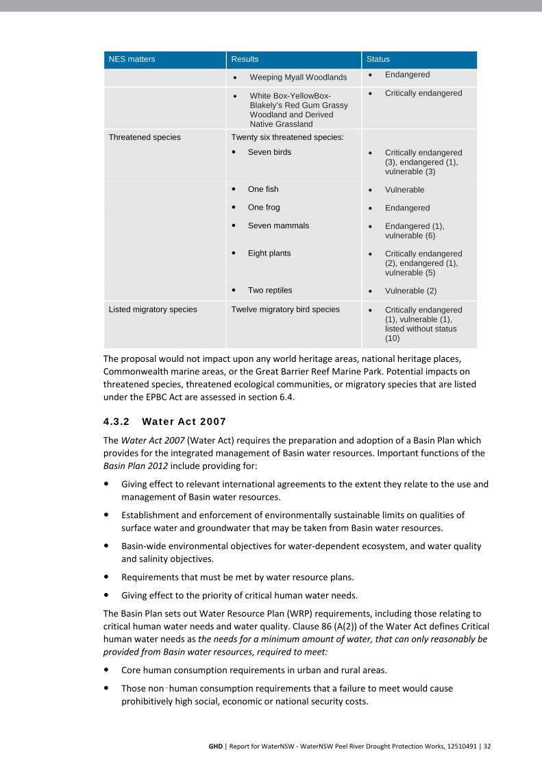
GHD | Report for WaterNSW - WaterNSW Peel River Drought Protection Works, 12510491 | 32
NES matters Results Status
• Weeping Myall Woodlands • Endangered
• White Box-YellowBox-Blakely’s Red Gum Grassy Woodland and Derived Native Grassland
• Critically endangered
Threatened species Twenty six threatened species:
Seven birds
• Critically endangered (3), endangered (1), vulnerable (3)
One fish • Vulnerable
One frog • Endangered
Seven mammals • Endangered (1), vulnerable (6)
Eight plants • Critically endangered (2), endangered (1), vulnerable (5)
Two reptiles • Vulnerable (2)
Listed migratory species Twelve migratory bird species • Critically endangered (1), vulnerable (1), listed without status (10)
The proposal would not impact upon any world heritage areas, national heritage places, Commonwealth marine areas, or the Great Barrier Reef Marine Park. Potential impacts on threatened species, threatened ecological communities, or migratory species that are listed under the EPBC Act are assessed in section 6.4.
4.3.2 Water Act 2007
The Water Act 2007 (Water Act) requires the preparation and adoption of a Basin Plan which provides for the integrated management of Basin water resources. Important functions of the Basin Plan 2012 include providing for:
Giving effect to relevant international agreements to the extent they relate to the use and management of Basin water resources.
Establishment and enforcement of environmentally sustainable limits on qualities of surface water and groundwater that may be taken from Basin water resources.
Basin-wide environmental objectives for water-dependent ecosystem, and water quality and salinity objectives.
Requirements that must be met by water resource plans.
Giving effect to the priority of critical human water needs.
The Basin Plan sets out Water Resource Plan (WRP) requirements, including those relating to critical human water needs and water quality. Clause 86 (A(2)) of the Water Act defines Critical human water needs as the needs for a minimum amount of water, that can only reasonably be provided from Basin water resources, required to meet:
Core human consumption requirements in urban and rural areas.
Those non‑human consumption requirements that a failure to meet would cause prohibitively high social, economic or national security costs.
GHD | Report for WaterNSW - WaterNSW Peel River Drought Protection Works, 12510491 | 33
Each WRP is to include a quality management plan which identifies water quality target values and measures to address the water quality of fresh water-dependent ecosystems, irrigation water and recreational purposes. WRPs are to describe how extreme dry periods and certain water quality events would be managed. If those dry periods or events would compromise a Basin State’s ability to meet critical human water needs, the WRP must set out measures to ensure critical human water needs are met (Part 13 (2)). The Water Resource Plan of relevance to the proposal is the Namoi WRP. The Namoi WRP covers all surface water in the Namoi and Peel valleys.
4.3.3 Native Title Act 1993
The objectives of the Native Title Act 1993 are to:
Recognise native title rights and sets down basic principles in relation to native title in Australia.
Provide for the validation of past acts which may be invalid because of the existence of native title.
Provide for a future regime in which native title rights are protected and conditions imposed on acts affecting native title land and waters.
Provide a process by which native title rights can be established and compensation determined, and by which determinations can be made as to whether future grants can be made or acts done over native title land and waters.
Provide for a range of other matters, including the establishment of a National Aboriginal and Torres Strait Islander Land Fund.
A search of the National Native Title Tribunal returned one registered claim. The proposal site falls within the area of claim lodged by the Gomeroi People. This claim was entered on the Register on 21 January 2012 and covers an area from the NSW and Queensland border in the north, the Hunter Valley to the south, west of Walgett and to the east of Tamworth. This area is shown in Figure 4-1. This application has not been determined.

GHD | Report for WaterNSW - WaterNSW Peel River Drought Protection Works, 12510491 | 34
Figure 4-1 Gomeroi People Native Title Claim area

GHD | Report for WaterNSW - WaterNSW Peel River Drought Protection Works, 12510491 | 35
5. Community and agency consultation 5.1 Community and stakeholder engagement plan
WaterNSW has prepared a Community and Stakeholder Engagement Plan (CSEP) for the proposal. The engagement plan outlines:
WaterNSW’s engagement goals and objectives
Key stakeholder groups
Risk management measures
Engagement tools
Policies and protocols for community and stakeholder engagement
WaterNSW aims to provide timely information to manage stakeholder and community expectations and build understanding of the proposal and its benefits. All communications and engagement activities would be guided by the following principles:
To clearly communicate the objectives of this project
Consult with stakeholders to inform the development of the detailed business case
Be proactive. Engage the stakeholders early in the process
Be open and honest in any communications
Be inclusive. Ensure stakeholders have access to the process and information about the study
Be responsive. Respond to stakeholder contact in a timely manner
Communication and engagement to be flexible and tailored to capture various stakeholders
Continual monitoring of activities to ensure communication and engagement requirements meet ongoing project stages
Keep stakeholders up dated and honour commitments made during consultation
Key stakeholder groups across the broader Tamworth area are listed in Table 5-1.
Table 5-1 Key stakeholders
Stakeholder Group Organisation Ministers Minister for Water
State Ministers Kevin Anderson MP for Tamworth
Federal Government Commonwealth Environmental Water Office
State Government Including: DPIE - EES Drought Commissioner James McTavish (Department of Premier and Cabinet) State emergency services (SES) Rural Fire Services DPIE, Water DPI - Fisheries NRAR
Local Government Tamworth Regional Council Tamworth Mayor Col Murray

GHD | Report for WaterNSW - WaterNSW Peel River Drought Protection Works, 12510491 | 36
Stakeholder Group Organisation Major customers Tamworth Regional Council
Irrigators and other water users
Peel River landholders
Indigenous Groups Tamworth Local Aboriginal Land Council Nungaroo Local Aboriginal Land Council
WaterNSW targeted stakeholder groups
Customer Advisory Groups (CAGs) River Operating Stakeholders Consulting Committee (ROSCCo) WaterNSW Operations Road show – community information sessions
General community Via media, community information session, WaterNSW webpage and WaterNSW Facebook
5.2 Consultation in preparation of this REF
Table 5-2 summarises the stakeholder communication and engagement activities that have been implemented for the preparation of this REF, and that would continue as the proposal is implemented.
Table 5-2 Summary of stakeholder communication and engagement
Date Stakeholders Communication activity 11 July 2019
Community and other stakeholders
Media release https://www.waternsw.com.au/about/newsroom/2019/community-information-sessions-planned-for-peel-river-landholders-and-users-re-drought-flow-cuts
18 July 2019
Peel River landholders, customers and stakeholders (324)
Notification/operations update Introduction to announcement and upcoming
projects
Dates for information sessions in August 2019
July and August 2019
Community and other stakeholders
Several media interviews for TV, print and radio including ABC Radio News 26 July, ABC Radio Breakfast 5th August, ABC Radio News 6th August, Prime TV coverage 5-6 August
24 July 2019
Community and other stakeholders
Peel Valley – Drought Operations Update – emailed (various stakeholders and landholders) and posted (324 affected landholders)
25 July 2019
Community and other stakeholders
Media release issued to Tamworth print and radio https://www.waternsw.com.au/about/newsroom/2019/drought-measures-key-community-information-sessions-for-peel-river-landholders-and-users
July 2019 Community and other stakeholders
Dedicated web pages for Peel Valley established on WNSW site along with a dedicated Facebook group established for Peel Valley
5 August 2019
Community and other stakeholders
Dungowan community information meeting – 97 attendees Landholders who had no alternate water source were identified and registered (12 landholders identified)
6 August 2019
Community and other stakeholders
Tamworth community information meeting – 65 attendees
Landholders identified in Dungowan Information session (12)
Follow up with 12 landholders to confirm their contact details and not having an alternate water source
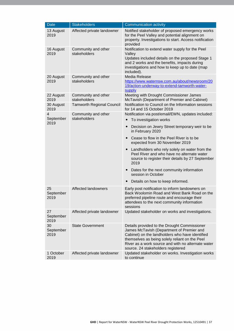
GHD | Report for WaterNSW - WaterNSW Peel River Drought Protection Works, 12510491 | 37
Date Stakeholders Communication activity 13 August 2019
Affected private landowner Notified stakeholder of proposed emergency works for the Peel Valley and potential alignment on property. Investigations to start. Access notification provided
16 August 2019
Community and other stakeholders
Notification to extend water supply for the Peel Valley Updates included details on the proposed Stage 1 and 2 works and the benefits, impacts during investigations and how to keep up to date (map included).
20 August 2019
Community and other stakeholders
Media Release https://www.waternsw.com.au/about/newsroom/2019/action-underway-to-extend-tamworth-water-supply
22 August 2019
Community and other stakeholders
Meeting with Drought Commissioner James McTavish (Department of Premier and Cabinet)
30 August 2019
Tamworth Regional Council Notification to Council on the Information sessions for 14 and 15 October 2019
4 September 2019
Community and other stakeholders
Notification via post/email/EWN, updates included: To investigation works
Decision on Jewry Street temporary weir to be in February 2020
Cease to flow in the Peel River is to be expected from 30 November 2019
Landholders who rely solely on water from the Peel River and who have no alternate water source to register their details by 27 September 2019
Dates for the next community information session in October
Details on how to keep informed.
25 September 2019
Affected landowners Early post notification to inform landowners on Back Woolomin Road and West Bank Road on the preferred pipeline route and encourage their attendees to the next community information sessions
27 September 2019
Affected private landowner Updated stakeholder on works and investigations.
30 September 2019
State Government Details provided to the Drought Commissioner James McTavish (Department of Premier and Cabinet) on the landholders who have identified themselves as being solely reliant on the Peel River as a work source and with no alternate water source. 24 stakeholders registered
1 October 2019
Affected private landowner Updated stakeholder on works. Investigation works to continue

GHD | Report for WaterNSW - WaterNSW Peel River Drought Protection Works, 12510491 | 38
Date Stakeholders Communication activity 9 October 2019
Community and other stakeholders
Notification via email to encourage stakeholders to attend next community information sessions. Session included: The final pipeline route and construction
timetable,
Progress on the planning and construction of the Dungowan temporary weir,
Possible options for alternate domestic water supply for affected landholders
The latest drought outlook
Details on how to keep informed
10 October 2019
Affected private landowner Updated stakeholder on revised alignment to follow existing pathways and property fence lines to minimise impacts
14 October 2019
Community and other stakeholders
Dungowan community information meeting (afternoon session at proposed temporary weir location) – 50 attendees Dungowan community information meeting (night session) – 65 attendees
15 October 2019
Community and other stakeholders
Tamworth community information meeting - estimated 50 attendees
On going Local business Continue negotiations with businesses to support works. Negotiations between WaterNSW and MPC Kinetic and local business
On going Community and other stakeholders
Regular updates of Peel River web page
On going Tamworth Regional Council Several meetings and project briefings On going State Government On-going updates provided to Drought
Commissioner James McTavish (DPC)

GHD | Report for WaterNSW - WaterNSW Peel River Drought Protection Works, 12510491 | 39
6. Environmental assessment The following section assesses the likely environmental impacts of the proposal and discusses the mitigation measures required to reduce those impacts to acceptable levels. The impact assessment is undertaken in the context of the:
Existing environmental conditions which are affected by prolonged drought. This has resulted in the Peel River Water Source being declared Stage 4 drought affected on the DPIE website.
The forecast cease to flow event downstream of Chaffey Dam in June 2020, resulting in the water requirements for the city of Tamworth not being able to be met under the do-nothing scenario.
Current water delivery operations with significant surface water losses along the Peel River between Chaffey Dam and Tamworth.
6.1 Hydrology and water quality
6.1.1 Methodology
The potential impacts of the proposal were assessed using:
Historical streamflow data within the Peel River at Tamworth and downstream of Tamworth to estimate the range of potential flows downstream of the proposed temporary intake structure, and the potential changes in flows as a result of the reduced discharges from Chaffey Dam and extractions at Dungowan.
Estimation of total transmission losses, and flows required to maintain existing pools in the Peel River.
Survey (LiDAR) data, to estimate the range of potential ponding associated with the proposed temporary weir.
6.1.2 Existing environment
Flows within the Peel River are maintained by Chaffey Dam and by unregulated tributary flows. Water is released from Chaffey Dam to provide water to licensed water users, including the domestic water supply for Tamworth. These discharges and tributary inflows result in near constant flows within the Peel River between the Chaffey Dam and Tamworth. Flows downstream of Tamworth reduce after water is extracted at the Calala WTP and other licensed extractions and infiltration and evaporation. Flows downstream of Tamworth are currently very low or have ceased due to a lack of tributary inflows and surface runoff as a result of the intense drought conditions. For example, the Peel at Bective approximately 36km downstream of Tamworth has had extended periods of zero or near zero flows for much of 2019. Carroll Gap which is a further 28km downstream of Bective and near the confluence with the Namoi River experiences increased flows and this is most likely due to inflows of groundwater.
River condition
Upstream of Tamworth, the Peel River includes a series of pools and riffles, with some meandering sequences. Figure 6-1 shows the Peel River at Woolomin. River banks are generally vegetated, with a tree canopy that shades the River. Water levels within the pools is maintained by the dam discharges. Water quality within these sections of the River is generally good, as a result of constant flushing of the pools.

GHD | Report for WaterNSW - WaterNSW Peel River Drought Protection Works, 12510491 | 40
The location of the proposed Dungowan intake structure includes an in-channel ponding area. This is shown in Figure 6-2. There is an existing low-level causeway at this location. This is shown in Figure 6-3.
Through Tamworth, the River has been largely straightened and channelized, with scattered remnant vegetation and predominantly grasses. This is shown in Figure 6-4.
Figure 6-1 Peel River at Woolomin
Figure 6-2 Peel River at the Dungowan site

GHD | Report for WaterNSW - WaterNSW Peel River Drought Protection Works, 12510491 | 41
Figure 6-3 Existing causeway at the Dungowan site
Figure 6-4 Peel River near Tamworth from the Solander Drive footbridge

GHD | Report for WaterNSW - WaterNSW Peel River Drought Protection Works, 12510491 | 42
Water levels in the Peel River at Tamworth are managed by a damaged weir at Jewry Street shown in Figure 6-5.
Figure 6-5 Peel River at the Jewry Street weir
As the river progresses downstream of Tamworth and flows become less, large disconnected pools have already formed due to the current climatic conditions.
Without regular turnover, water quality within the pool upstream of the Jewry Street weir is considered to be poor, and would worsen as inflows reduce. Downstream of Tamworth, the river banks are largely denuded of vegetation, which has resulted in the deep incising of the river channel. DPIF has recently undertaken works to clear weeds and plant native vegetation along some sections of the river. The water is generally turbid, with high suspended sediments likely sourced from the exposed clay soils along the river banks.
Water usage
Tamworth requires about 22 ML/day to meet water supply demands. During drought conditions, all of this water is delivered from Chaffey Dam as Dungowan Dam is not used. The Calala WTP’s water extraction point for the Tamworth supply is about 40 km downstream of Chaffey Dam.
It is estimated that at times about 44 ML/day is required to be discharged from Chaffey Dam to enable the Calala WTP to extract 22 ML/day. Transmission losses (the volume of water lost between Chaffey Dam and Tamworth) are estimated to be of the order of 22 ML/day, with about half (11 ML/day) being lost between Chaffey Dam and the location of the Dungowan site. The remaining 11 ML/day is lost between the Dungowan site and Tamworth.
Transmission losses include:
Infiltration and groundwater recharge
Evaporation losses (primarily from open pools)

GHD | Report for WaterNSW - WaterNSW Peel River Drought Protection Works, 12510491 | 43
Stock and domestic and other licenced usage.
Modelling has shown that with an average flow width of about six metres and evaporation rate of about five mm per day, evaporation is estimated to account for about 12 ML of the 22 ML loss over the 40 km between Chaffey Dam to Tamworth. The remaining 10 ML per day estimated loss is attributed to infiltration and groundwater recharge.
Figure 6-6 shows the historical range of average stream flows within the Peel River at Tamworth (gauge ID 419070) between July 1998 and August 2019. This figure indicates that flows within the Peel River are generally lower during summer (December to February) and autumn (March to May), with appreciably more flows historically occurring during winter and spring.
Comparing the historical stream flows with recent observed stream flows, it is apparent that flows over the last five months have been primarily due to discharges from Chaffey Dam, with little to no local catchment runoff. Without substantial rainfall, flows within the river are likely to remain at these record low levels, with any water within the Peel River largely the result of discharges from Chaffey Dam. Figure 6-6 shows the 2019 flows compared to historical flows.
Figure 6-6 Historical and 2019 flows
6.1.3 Impact assessment
The proposed temporary weir and water intake at Dungowan have the potential to impact local hydrology, through the impoundment of water behind the weir, and extraction of river water by pumping. Construction has the potential to impact water quality through disturbance of the river bank causing sedimentation of the water, and from potential chemical and fuel spills from equipment.
Operation of the proposal has the potential to cause minor inundation of surrounding areas if the amount of water stored temporarily upstream of the weir overtops the bank. The height of the temporary weir would be confirmed at the detailed design stage. The detailed design is to be developed so that the inundation area does not exceed the top of the river bank, and therefore would avoid potential inundation and flooding impacts on adjacent lands. Water releases from Chaffey Dam would also be co-ordinated with the water intake pumping rates so that water storage would be contained within the riverbanks.

GHD | Report for WaterNSW - WaterNSW Peel River Drought Protection Works, 12510491 | 44
Operation of the proposal has the potential to cause minor flooding impacts on adjoining land in the event of a significant rainfall event. If the weir is not removed, partially or totally, inundation would occur immediately upstream of the weir and downstream if water overtops the weir. The weir would be constructed from a series of prefabricated concrete culverts. One or more of the culvert sections could be removed in the event of a significant rain event. This would allow flows to pass and prevent flooding of adjoining land.
During operation, the temporary weir would enable water to pass over and connect sections of the river downstream. The temporary weir would include an overflow section in the middle section of the river, between 100 mm and 300 mm below the top of the weir. This invert would allow environmental water releases and tributary flows to pass downstream and provide water connectivity. Scour protection would be installed on the downstream side of the weir, made of gabion or rip rap. This would be designed to minimise scour and water quality impacts.
Water releases from Chaffey Dam would be co-ordinated with the water intake pumping rates so that water storage would be contained within the riverbanks, and environmental flows could pass. This would also allow any tributary flows from the Dungowan Creek catchment to pass downstream.
Construction of the temporary intake structure at Dungowan would create a low, in channel pond within the Peel River. Depending on the storage requirements needed to meet the temporary pumping requirements (subject to detailed design), the volume of the pond would be between 1 ML (equivalent to about an hour of pumping) and 22 ML (equivalent to a day of pumping). It is expected that an intermediate volume (about 5 ML) would be adequate to provide flexibility in pumping and manage variation in inflows.
Figure 6-7 presents the indicative upstream ponded areas that may occur. If 1 ML of storage is adopted, approximately 375 metres upstream of the weir would be filled for storage until it is pumped out. If 5 ML of storage is required, approximately 470 metres upstream of the weir would be filled, with additional ponding at approximately 625 metres where pools are currently located. With 22 ML storage an area of approximately 830 metres would be filled, and the pools at 625 metres and upstream would be connected.

GHD | Report for WaterNSW - WaterNSW Peel River Drought Protection Works, 12510491 | 45
Figure 6-7 Indicative ponding areas
Stream flows – Chaffey Dam to Dungowan
The reduced transmission losses that would occur as a result of proposal (approximately 11 ML/day) would mean that to meet the demands at Tamworth, discharges from Chaffey Dam are expected to be reduced from about 44 ML/day to about 33 ML/day. Although this would result in a 25% reduction in flows between Chaffey Dam and Dungowan, the flow is sufficient to maintain periodic connectivity between the existing pools. As a result, no further mitigation of this section of the River is expected to be required. There would continue to be about 11 ML/day in transmission losses between Chaffey Dam and Dungowan.
Stream flows – Dungowan to Tamworth
Flows within the Peel River during drought times are dominated by discharges from Chaffey Dam. The proposal would extract about 22 ML/day from the river at Dungowan. Assuming the total removal of this water, and no additional discharges from Chaffey Dam such as the proposed environmental releases, the estimated change in the flow-exceedance curve shown in Figure 6-8 is considered likely. Figure 6-8 indicates that with the temporary water intake and pumping station in place, river flows at Tamworth would be negligible (less than about one ML/day) for 10% of days (long term average), compared to the current 1% of days (long term average).

GHD | Report for WaterNSW - WaterNSW Peel River Drought Protection Works, 12510491 | 46
In the absence of tributary inflows from Dungowan Creek and Cockburn Creek, and the proposed environmental pulse releases, it is expected that extraction of 22 ML/day at Dungowan would result in the eventual drying of all ponds between Dungowan and Tamworth. The environmental pulse releases from Chaffey Dam would provide some water to flow over the temporary weir at Dungowan. Tributary flows from Dungowan Creek would also be able pass over the weir downstream. These bypass flows would top up the pools in the Peel River downstream of Dungowan. These flows would connect pools and provide some flushing to turn water over. This would assist to maintain the aquatic habitats therein. Some of the environmental releases and tributary flows would make its way towards Tamworth, but this would not be a regular supply or continuous flow.
Figure 6-8 shows the changes to the probability of flow volumes at Tamworth after the water intake is installed at Dungowan. Under historical conditions, releases from Chaffey Dam and water flows from rainfall, have a probability of 98% that 10 ML/day would reach Tamworth. After the installation of the proposal, this probability drops to 79%. For a volume of 100 ML/day reaching Tamworth down the Peel River, the historical probability is 25%. After the installation of the proposal, this would be reduced to 20%.
Figure 6-8 Daily flow exceedance probability – Peel River at Tamworth
Without tributary inflows, no water is expected to flow past the Tamworth Council pump site (gauge no 419070). WaterNSW has consulted with water users downstream of Tamworth, including holders of stock and domestic water licences. Alternative water management arrangements are being developed for these licence holders. More details are provided in Section 6.5 (land use).
6.1.4 Mitigation measures
The design of the temporary weir and intake structure at Dungowan has been developed to allow some downstream flows to be maintained. Operation of the proposal would involve coordinating water releases from Chaffey Dam so that any environmental flows are allowed to pass over the temporary weir and travel downstream of Dungowan. This would provide water connectivity between the sections of the Peel River upstream and downstream of the temporary weir.
Environmental pulse flows are proposed from Chaffey Dam and would be able to pass downstream of the Dungowan intake. These flows are proposed as weekly pulse releases of up to 30 ML from Chaffey Dam and notionally released over one day each week or less frequently while water quality remains stable or tributary inflows occur. The environmental flows are to maintain habitat downstream of Dungowan. The release of these environmental flows, and particular at what volume and interval, would be determined as part of the management of

GHD | Report for WaterNSW - WaterNSW Peel River Drought Protection Works, 12510491 | 47
the proposal. Flows may be released as larger volumes less frequently, or as smaller volumes more often.
These discharge options would be sufficient to top up the water lost to evaporation and infiltration from the stream pools. By undertaking these environmental pulse releases in brief, regular intervals, the estimated transmission losses between Dungowan and Tamworth are expected to reduce by about 90% when compared to lower volumes released more often.
Mitigation measures for potential impacts on hydrology and water quality are provided in Table 6-1.
Table 6-1 Hydrology and water quality mitigation measures
Hydrology and flooding mitigation measures
Impact Mitigation measure Responsibility Timing
Erosion and sedimentation
The construction contractor would develop an Erosion and Sedimentation Control Plan (ESCP). The ESCP would include appropriate erosion and sediment controls
Construction contractor
Construction
Any material removed from the waterway that is to be temporarily deposited or stockpiles on land is to be located well away from the waterway and to be contained by appropriate sediment control devices.
Construction contractor
Construction
Rehabilitation would be undertaken in construction areas including ground stabilisation and establishment of vegetative groundcover where appropriate.
Construction contractor
Construction
Water Quality A water quality monitoring plan would be developed by WaterNSW and implemented for the duration of the proposal. The water quality monitoring plan would be developed in consultation with DPI-F.
WaterNSW Operation
Flood A flood contingency plan would be in place so that any stockpiles, machinery, equipment are relocated temporarily in the event of a known upcoming large rainfall or flood event.
Construction contractor
Pre-construction, Construction
Rehabilitation and stabilisation
The ground would be reinstated to a similar level to pre-construction so there are no changes to surface drainage or flow patterns.
Construction contractor
Post-construction
6.2 Aboriginal heritage
Aboriginal heritage refers to both Aboriginal archaeological sites, and sites or places of cultural value to Aboriginal people. These are protected under the NPW Act as Aboriginal Objects and Aboriginal Places.
The proposal is located in the Nungaroo LALC area. The Nungaroo and Tamworth LALCs were consulted during preparation of the Aboriginal heritage assessment. The Tamworth LALC was consulted because at the time the report was prepared, the proposal included works at Jewry Street weir which is in their area. The proposal has been refined and no longer involves work at the Jewry Street weir.

GHD | Report for WaterNSW - WaterNSW Peel River Drought Protection Works, 12510491 | 48
6.2.1 Methodology
The Aboriginal heritage assessment was conducted by Virtus Heritage. The cultural values of the proposal area were assessed during a field survey accompanied by a representative of the Tamworth LALC. The Tamworth and Nungaroo LALCs were provided the opportunity to comment on a draft assessment that was completed using database searches and literature review.
The Aboriginal heritage assessment was completed following the NSW Office of Environment and Heritage (OEH) Due Diligence Code of Practice for the Protection of Aboriginal Objects in NSW.
Database searches
The following heritage registers and database searches were completed as part of the preliminary assessment:
National Native Title Tribunal (NNTT)
Aboriginal Heritage Information Management System (AHIMS)
The Australian Heritage Database (AHD)
State Heritage Register (SHR) and Inventory (SHI)
Tamworth Regional Local Environmental Plan 2014
Engagement with LALC
The Tamworth and Nungaroo LALCs have inspected the sites and been provided with an opportunity to comment on the draft assessment. Comments were received on 22 August by Tamworth LALC. These comments have been considered when finalising the Aboriginal heritage assessment. Nungaroo LALC did not provide comments.
Previous Archaeological Research
A review of the Department of Planning, Industry and Environment - Environment, Energy and Science (EES)) (formerly OEH) AHIMS library and online searches were completed to obtain copies of previous Aboriginal Heritage studies and archaeological investigations within the area surrounding the proposal site. These include:
Navin Officer Heritage Consultants, 2012. Chaffey Dam Augmentation and Safety Upgrade Aboriginal Cultural Heritage Assessment. Report for Worley Parsons.
Everick Heritage Consultants 2015. Aboriginal Cultural Heritage Assessment, Glen Artney Industrial Development West Tamworth, NSW. Report prepared for Tamworth Regional Council.
Everick Heritage Consultants 2014 (a) Cultural Due Diligence Assessment of the Tamworth Council’s South Tamworth Rural Lands Master Plan for the Duri Road Site, Tamworth NSW. Report prepared for Tamworth Regional Council.
Everick Heritage Consultants 2014 (b) Cultural Due Diligence Assessment of the Tamworth Council’s South Tamworth Rural Lands Master Plan for the Goonoo Goonoo Road Site, Tamworth, NSW. Report prepared for Tamworth Regional Council.
Gaynor, P 2011. An Archaeological Survey of Part Lot 191 DP 1107583 near Calala Lane at Tamworth in North-Western NSW. Report prepared for Brown and Krippner.

GHD | Report for WaterNSW - WaterNSW Peel River Drought Protection Works, 12510491 | 49
Gaynor, P 2004. An Archaeological Survey of the Protected Levee Bank Route around the Taminda Section of Tamworth in North-Western NSW. Report prepared for Tamworth Regional Council.
Gaynor, P and Wilson, J 1995. An Archaeological Survey of the Proposed Botanic Gardens on Endeavour Drive Tamworth NSW. Report prepared for Tamworth City Council.
Site inspections
Virtus Heritage completed two site inspections for the proposal area. A representative of the Tamworth LALC, Mr Donny Ferner, was involved in the site inspection on 31 July 2019. Mr Ferner was involved in previous studies in the area, including the 2012 surveys for the Chaffey Dam Augmentation and Safety Upgrade. Mr Ferner has knowledge of the closest recorded sites to the proposal area. The site inspection was limited to areas where landholder access was permitted, areas with ground visibility for artefact detection and to road easements that could be accessed safely. The site inspection combined pedestrian and vehicle transects.
A second site inspection took place on 16 August 2019. Whilst this visit was primarily arranged to inspect properties that would be crossed by the proposed Stage 2 pipeline, the area of the proposed Dungowan water intake was also inspected.
6.2.2 Existing environment
The Kamilaroi people have had a presence in the New England area for many thousands of years. The Kamilaroi communities were loosely bound by a common language, spoken in different dialects. Two groups of Kamilaroi people in the area that became known as Tamworth were the Moonbi people from the foot of the Moonbi Ranges, and the Goonoo Goonoo people from the flat land besides the Peel River. The ‘Corbon Gamilaroi’ people occupied the valleys of the Namoi, Peel and Gwydir Rivers.
The broader proposal area has been affected by disturbance from European settlement. Activities include grazing, cropping, intensive agriculture, forestry, mining and urban development. The area to the south of Dungowan, upstream from the proposal site, has been significantly disturbed by the construction of Chaffey Dam in 1979. Construction of the dam involved extensive disturbance from earthworks, heavy machinery and the construction of canals and spillways. The modification of these landforms would have contributed to the disturbance, mixing and stripping of topsoils and subsoils. The disturbance has potentially disturbed and removed archaeological deposits. This does not exclude the potential for extant evidence of Aboriginal occupation, and the proposal area still has potential for extant evidence of Aboriginal occupation.
Database search results
National Native Title Tribunal
A search of the National Native Title Tribunal returned one registered claim. The proposal site falls within the area of claim lodged by the Gomeroi People. This claim was entered on the Register on 21 January 2012 and covers an area from the NSW and Queensland border in the north, the Hunter Valley to the south, west of Walgett, and to the east of Tamworth. This area is shown in Figure 4-1. As this application has not been determined, the native title claim would not prevent Crown Land from granting access for the proposal.
Aboriginal Heritage Information Management System (AHIMS)
A search of the AHIMS database was completed on 23 July 2019 for a 200 metre buffer area around the proposal site. No previous recordings were identified within 250 metres of the Dungowan site.

GHD | Report for WaterNSW - WaterNSW Peel River Drought Protection Works, 12510491 | 50
Australian Heritage Database (AHD)
The AHD was searched on 23 July 2019 for all Indigenous heritage items within the Tamworth Regional Local Government Area. The results of the search identified no Indigenous heritage items within the proposal area.
NSW State Heritage Register and NSW State Heritage Inventory
The State Heritage Register includes listings for State significant heritage items. This database was searched on 23 July 2019. The results of the search identified no Indigenous heritage items within the proposal area.
The State Heritage Inventory includes heritage listings from local and regional planning instruments, and heritage studies and State Significant heritage items. The results of the search identified no Indigenous heritage items within the Tamworth Regional Local Government Area.
Tamworth Regional Local Environmental Plan 2010
Schedule 5 of the Tamworth Regional Local Environmental Plan 2010 was searched on 29 July 2019. The results of the search identified no Indigenous heritage items within the Tamworth Regional Local Government Area.
Summary of database search results, literature review and preliminary assessment
No Aboriginal sites were located within 250 metres of the proposal site. The proposal area is within close proximity to a permanent watercourse. The AHIMS search results show the broader area contains a number of Aboriginal sites including artefacts, stone quarries, modified trees and ceremonial grounds. The proposal area is within a sensitive cultural landscape known to contain Aboriginal sites such as alluvial flats near a permanent watercourse. The area however has been subject to disturbance from past and current land uses including grazing, cropping, forestry and infrastructure development.
Predictive model
Based on the known archaeological, environmental and landscape context of the broader proposal area, a predictive model for evidence of Aboriginal occupation has been developed. The predictive model assesses the likelihood of the following Aboriginal site types being located within the broader proposal area:
Scarred trees and carved trees
Isolated artefacts and open campsites (artefact scatters)
Potential Archaeological Deposits (PADs)
Middens
Petroglyphs
Aboriginal axe grinding grooves
The archaeological potential for these of Aboriginal site types to be present is assessed using the following definitions:
Low to zero
Low
Moderate
High

GHD | Report for WaterNSW - WaterNSW Peel River Drought Protection Works, 12510491 | 51
The predictive model is a tool for targeting areas of high potential for the site investigations. Previous and current agricultural land uses have decreased the likelihood of scarred trees being extant within the proposal area due to land clearing. Artefact scatters and isolated finds are the most likely site type to occur. However, surface Aboriginal objects are likely to have been displaced or destroyed by the agricultural practices and land clearing, as well as natural erosional processes.
There is only moderate potential for soils to contain buried Aboriginal objects and occupation deposits, again due to agricultural practices and land clearing. Other site types are unlikely to occur in the proposal area due to a lack of suitable topography and geology, and the significant extent of ground disturbance.
6.2.3 Impact assessment
The majority of the temporary transfer pipeline is to be laid overland within an existing disturbed road and access track. There is low potential for Aboriginal archaeological deposits within this alignment. The temporary pipeline would be installed aboveground. The pipeline would be trenched or directionally drilled to cross Duri-Dungowan Road. This area is highly disturbed from the construction and operation of the road.
The alluvial terrace adjoining the location of the proposed intake structure is of moderate sensitivity. The alluvial terrace is considered to be a Potential Archaeological Deposit (PAD) site. This is based on the DPIE’s due diligence code of practice and previous archaeological research. The PAD area is mapped in Figure 6-9.
An isolated basalt broken flake and a potential Aboriginal scarred tree and were identified within the alluvial terrace, to the east of Dungowan Sports Field and outside of the proposal’s impact area. The location of these two items are shown in Figure 6-10. Figure 6-11 shows a photograph of the broken basalt flake, with a pen as reference for size. Figure 6-12 shows a photograph of the potential Aboriginal scarred tree within the Dungowan Sports Ground.
The proposed Dungowan intake structure and temporary weir have been located to avoid the PAD associated with the alluvial terrace adjacent to the Peel River. The location has also been selected to avoid the area of the Aboriginal scarred tree and isolated find (basalt flake) to the east of Dungowan Sports Ground.
Excavation of the river bank is required to install the prefabricated concrete head wall and intake structure. The structures would be installed in the area of disturbance associated with the existing 4WD crossing point. Excavation would take place from the disturbed ground of the 4WD crossing, and would avoid the alluvial terrace.
The route for the temporary transfer pipeline has also been selected to avoid areas of cultural sensitivity. The transfer pipeline would be installed overland and not trenched. This design has been adopted to further avoid ground disturbance. The route was selected to avoid impacts to the area of the Aboriginal scarred tree and isolated find (basalt flake), the east of Dungowan Sports Ground.

GHD | Report for WaterNSW - WaterNSW Peel River Drought Protection Works, 12510491 | 52
Figure 6-9 Dungowan PAD site location
Restricted to licence users only.

GHD | Report for WaterNSW - WaterNSW Peel River Drought Protection Works, 12510491 | 53
Figure 6-10 Scarred tree and basalt flake location
Restricted to licence users only.

GHD | Report for WaterNSW - WaterNSW Peel River Drought Protection Works, 12510491 | 54
Figure 6-11 Broken basalt flake
Figure 6-12 Potential Aboriginal scarred tree within the Dungowan Sports Ground
6.2.4 Mitigation measures
The design of the proposal has been developed to avoid impacts to areas of cultural sensitivity. The avoidance approach has been adopted so that site infrastructure and construction impacts are located away from culturally sensitive areas. AHIMS site records are to be prepared for the objects identified during the Aboriginal heritage assessment.
Mitigation measures for potential impacts on Aboriginal heritage are provided in Table 6-2.

GHD | Report for WaterNSW - WaterNSW Peel River Drought Protection Works, 12510491 | 55
Table 6-2 Aboriginal heritage mitigation measures
Aboriginal heritage mitigation measures Impact Mitigation Responsibility Timing
General All site workers and personnel are to be inducted and briefed on the possible identification of Aboriginal sites and objects during construction. The induction would cover responsibilities according to the provisions of the NPW Act, with particular reference to the case where any unknown objects or items are uncovered during construction.
WaterNSW
Construction contractor
Pre-construction
Construction
As part of the induction, the following contact phone numbers would be given to all site personnel in the case that unknown Aboriginal objects or items of historical heritage are uncovered during construction:
The Department of Premier and Cabinet regional archaeologist
EnviroLine 131555
The Project Manager responsible for supervising the works
WaterNSW
Construction contractor
Pre-construction
Construction
All personnel are to be made aware of their personal responsibility under Section 90 and 91A of the NPW Act to ensure that works cease within the vicinity of an Aboriginal object or site until further assessment is made by a qualified archaeologist and a representative from Nungaroo LALC.
WaterNSW
Construction contractor
Pre-construction
Construction
In the unlikely event that suspected human remains are uncovered during construction, all works would cease immediately. The area would be secured and NSW Police notified. If remains are deemed to require archaeological investigation by the NSW Police or NSW Coroner, then the EnviroLine (131 555), the Biodiversity and Conservation Division of DPIE and Nungaroo LALC are to be contacted. No works would continue until DPIE provides written clearance to proceed.
WaterNSW
Construction contractor
Construction
GHD | Report for WaterNSW - WaterNSW Peel River Drought Protection Works, 12510491 | 56
6.3 Non-Aboriginal Heritage
6.3.1 Existing environment
A desktop assessment was conducted on 20 August 2019 to assess the non-Aboriginal heritage issues present for the proposal. A search of the following databases was conducted:
The Australian Heritage Database
The State Heritage Register and Inventory
The Tamworth Regional Local Environment Plan LEP 2010
There are no non-Aboriginal heritage items recorded on these registers within proximity of the proposal site.
6.3.2 Impact assessment
No known items of non-Aboriginal heritage would be impacted by the construction or operation of the proposal because none are recorded at the proposal site
6.3.3 Mitigation measures
Mitigation measures for potential impacts on Non-Aboriginal heritage are provided in Table 6-3.
Table 6-3 Non-Aboriginal heritage mitigation measures
Non-Aboriginal heritage mitigation measures
Impact Mitigation measure Responsibility Timing
Unexpected discovery and accidental impact to heritage objects or artefacts
As part of the site induction, all workers would be advised of their obligations in relation to heritage before construction begins, namely what to do in the event of an unexpected find (see below).
Construction contractor
Pre-construction
In the event of an unexpected find of an archaeological deposit (or suspected item), work would cease in the affected area and the WaterNSW project manager would be contacted for advice on how to proceed.
Construction contractor
Construction
6.4 Biodiversity
6.4.1 Methodology
The assessment of the proposal’s potential impacts on biodiversity values of the area surrounding the proposal site involved the following.
Database searches and literature review
The Commonwealth DoEE Protected Matters Search Tool (PMST) for MNES listed underthe EPBC Act including threatened and migratory biota, known or predicted to occur in thelocality of the proposal.
DoEE online species profiles and threats database.
NSW Biodiversity Conservation Division (BCD) Wildlife Atlas database (licensed) forrecords of threatened species, populations and endangered ecological communities listedunder the BC Act that have been previously recorded within the locality of the proposal.

GHD | Report for WaterNSW - WaterNSW Peel River Drought Protection Works, 12510491 | 57
BCD threatened biota profiles for descriptions of the distribution and habitat requirements of threatened biota. This resource was also used to identify the suite of threatened ecological communities (TECs) and threatened species that could potentially be affected by the proposal and to inform habitat assessments.
The NSW Vegetation Information System: Classification (VIS) to identify matching plant community types (PCTs) in the proposal area.
The Atlas of Groundwater Dependent Ecosystems (GDEs).
Aerial photographs and satellite imagery of the proposal area.
Priority weed declarations for Biosecurity Act listed species in the Central Tablelands region, which includes the Tamworth LGA.
Directory of Important Wetlands in Australia.
The biodiversity studies and management plans associated with the Chaffey Dam Augmentation Project that was approved in 2014.
Department of Primary Industries Freshwater threatened species distribution maps.
Based on the database searches and literature review, a Likelihood of Occurrence assessment was completed for threatened species in the area of the proposal. This assessment informed preparation for site inspections.
Site inspection
A site inspection was completed on 29 and 30 July by two GHD ecologists (terrestrial and aquatic). The site inspections was completed in order to:
Validate the regional vegetation mapping and to confirm vegetation community type/s within the proposal area.
Assess the types and quality of fauna habitats present.
Assess the potential for threatened species to occur and be impacted.
Assess the condition of the Peel River.
Assess the potential for downstream impacts to biodiversity values.
6.4.2 Existing environment
Terrestrial environment - vegetation
The Dungowan site is located within a riparian zone of the Peel River. It features box woodland types flanking a gallery forest dominated by River Oak (Casuarina cunninghamiana ssp. cunninghamiana) on the river bank. Dungowan Park itself is maintained as a public sporting field and as such is dominated by introduced lawn grasses suitable for sporting purposes. Within the roadside of Duri-Dungowan Road, the groundcover is predominantly introduced grasses and groundcover weeds under a diffuse canopy of box eucalypt trees. Understorey throughout the proposal area is generally in poor condition, being highly modified and dominated by introduced grasses.
Plant community types
Three native plant community types (PCTs) were identified within the proposal area. These are described in Table 6-4 and shown in Figure 6-13.

GHD | Report for WaterNSW - WaterNSW Peel River Drought Protection Works, 12510491 | 58
Table 6-4 Plant community types
PCT Description PCT 433 – White Box grassy woodland to open woodland on basalt flats and rises in the Liverpool Plains sub-region, Brigalow Belt South Bioregion
This PCT consists of tall to mid high open woodland with trees dominated by Eucalyptus albens (White Box). Within the proposal area this community was found within the road easement along Duri-Dungowan Road including the strip of vegetation that runs along the adjacent block of land. The condition of this plant community type within the proposal area is typically low. It has an intact canopy consisting of mature E. albens and an understorey dominated by opportunistic weed species such as Opuntia stricta (Prickly Pear) and Paspalum sp. (Paspalum).
PCT 599 – Blakely’s Red Gum – Yellow Box grassy tall woodland on flats and hills in the Brigalow Belt South Bioregion and Nandewar Bioregion
This PCT was once widespread throughout the Nandewar Bioregion and the east of the Brigalow Belt South Bioregion but has been significantly cleared. This tall woodland is dominated by Blakely’s Red Gum (Eucalyptus blakelyi) and Yellow Box (Eucalyptus melliodora) with Rough Barked Apple (Angophora floribunda) and White Box (Eucalyptus albens) scattered throughout flat areas. Within the proposal area this vegetation zone is present as remnant canopy trees surrounding patchy exotic grasses. Closer to the Peel River there were some native grasses present such as Kangaroo Grass (Themeda triandra) and Weeping Grass (Microlaena stipoides ssp. stipoides).
PCT 84 River Oak – Rough-barked Apple – red gum – box riparian tall woodland (wetland) of the Brigalow Belt South Bioregion
This riparian PCT dominates the banks of the Peel River from the Chaffey Dam to Tamworth. It is found on the banks of rivers and creeks in low hills throughout the Brigalow Belt South Bioregion. The condition of this vegetation varies along the Peel River, with areas exposed to grazing or the presence of Salix sp. (Willow). The community is heavily disturbed through erosion bank instability and also due to an existing frequently used four wheel drive river crossing being present at the proposed water intake site.

"ª!
DURI-DUNGOWAN ROAD
NUNDLE ROAD
DURI
-DUN
GO
WAN
RO
AD
BACKW
OOLOM
INRO
AD
DUNGOWANRECREATION
GROUND
FIGURE 6-13
0 20 40 60 80 100 120
Meters
Project No.Revision No. 0
12510491Date 15 Oct 2019
Water NSWPeel Drought Temporary Works and
Chaffey Dam PipelineReview of Environmental Factors - Stage 1
Map Projection: Transverse MercatorHorizontal Datum: GDA 1994Grid: GDA 1994 MGA Zone 56
Paper Size ISO A4
oData source: LPI:CDB\DTDB, 2017. OEH: Vegetation, 2019. © Department of Finance, Services & Innovation 2017. Created by: tmorton, TMortonG:\22\12509994\GIS\Maps\Deliverables\REF\Stage1\12509994_REF_S107_Dungowan_PCT_Vegetation_0.mxd
Print date: 15 Oct 2019 - 09:29
LegendDPL transfer pipe - Option 1
"ª! PumpBlakely's Red Gum - Yellow Box grassy tallwoodland on flats and hills in the Brigalow BeltSouth Bioregion and Nandewar BioregionBlakely's Red Gum - Yellow Box grassywoodland of the New England TablelandsBioregionCandidate Native GrasslandsNon-NativeRiver Oak - Rough-barked Apple - red gum -box riparian tall woodland (wetland) of theBrigalow Belt South and Nandewar BioregionsWhite Box - White Cypress Pine - Silver-leavedIronbark grassy woodland on mainly clay loamsoils on hills mainly in the Nandewar BioregionWhite Box - White Cypress Pine shrubby hillsopen forest mainly in the Nandewar BioregionWhite Box grassy woodland to open woodlandon basalt flats and rises in the Liverpool Plainssub-region, BBS BioregionYellow Box - White Box - Silvertop Stringybark -Blakely's Red Gum grass shrub woodlandmainly on the Liverpool Range, Brigalow BeltSouth Bioregion
PCTs at Dungowanwater intake and transfer pipeline site
GHD | Report for WaterNSW - WaterNSW Peel River Drought Protection Works, 12510491 | 60
Priority and environmental weeds
Two priority weeds listed under the Biosecurity Act 2015 for the North West region (which includes Tamworth LGA) were recorded in the proposal area. These are a Willow species (Salix sp.) and Blackberry (Rubus fruticosus).
Both species are regulated with a general biosecurity duty to prevent, eliminate or minimise any biosecurity risk they may pose. Any person who deals with any plant, who knows (or ought to know) of any biosecurity risk, has a duty to ensure the risk is prevented, eliminated or minimised, so far as is reasonably practicable. Additional regulatory measures applicable to these weeds include:
Prohibition on dealings - Must not be imported into the State or sold (Blackberry and Willow species).
Regional measure - The plant should not be bought, sold, grown, carried or released into the environment (Blackberry only).
Both priority weeds mentioned above are also Weeds of National Significance declared under the National Weed Strategy, which recommends that their spread should be minimised to protect priority assets.
Terrestrial environment - habitat
Riparian woodland and forest
The main terrestrial fauna habitats featured in the proposal area comprises riparian open woodland and tall River Oak forest, which could provide:
Suitable nest sites for nest-building birds
Movement corridors for fauna along the river
Potential hollow resources (particularly in box species, which readily form hollows) for hollow-dependent mammals (e.g. microbats, possums) and birds
Blossom and nectar resources for nectarivorous species such as honeyeaters and parrots
The woodland and forest habitat has sub-optimal value for a large number of native fauna species as it lacks understorey complexity in the form of a well-developed shrub layer, ground timber debris, and native groundcovers (particularly tussock-forming grasses). The proximity to water may provide some habitat for small woodland birds such as thornbills and finches. There are few to no feed species for specialist feeders, such as Amyena (mistletoe) and Allocasuarina (sheoak) species. Buildings around Dungowan Park, and the bridge on Duri-Dungowan Road could also provide roost sites for cave-roosting bat species.
River bank
The Booroolong Frog (Litoria booroolongensis), which is listed as an endangered species under both the EPBC Act and BC Act, is associated with cobble banks and rock structures within stream margins and is known to occur upstream of Chaffey Dam. The banks of the Peel River within the Dungowan site could provide suitable habitat for this species. However, shading of the banks and water by mature River Oak trees may reduce the suitability of habitat for this species by reducing basking sites for adult frogs, or by lowering sub-surface temperatures, which may inhibit larval growth (DoE, 2019a). The existing 4WD crossing may also reduce habitat value at this location through disturbance. The river upstream of the proposed Dungowan temporary weir is likely to better support this species’ habitat requirements due to its preference for the headwaters of rivers with isolated pools, rather than large, deep, fast flowing sections.

GHD | Report for WaterNSW - WaterNSW Peel River Drought Protection Works, 12510491 | 61
The stream and stream bank habitats would also provide habitat for a range of waterbirds, such as Pacific Black Duck (Anas superciliosa) and Eurasian Coot (Fulica atra), and Australasian Grebe (Tachybaptus novaehollandiae), as well as a number of common frog species and reptiles, such as the Red-bellied Black-snake (Pseudechis porphyriacus).
Aquatic Environment
Based on the habitat observed during the July 2019 site visit, the Peel River downstream of Chaffey Dam is likely to support a range of aquatic biota including fish, macroinvertebrates, frogs. Instream habitat includes aquatic plants (macrophytes), overhanging habitat, submerged woody habitat and detritus. Given the drought conditions experienced in Tamworth, the Peel River is one of the few permanent water sources in the region, with most unregulated waterways in the region (e.g. Cockburn River) with no water present. Therefore, the Peel River would currently be providing valuable habitat for aquatic species.
At the current discharge rates (approximately 44ML/day), the section of the river between Chaffey Dam and Dungowan comprises a sequence of pools and faster flowing, shallow riffles, along a meandering channel. During the July 2019 site visit the instream habitat within the Peel River between Chaffey Dam and Dungowan was the least disturbed of the sections observed. This section of the river contains boulders, cobbles and gravel and a largely intact riparian zone providing shading and detritus. The frequent alternation of pool and flowing/riffle habitats would allow for a range of taxa with different habitat preferences to inhabit this section of the river. One of the most valuable pools in terms of instream habitat is located shortly downstream (within approximately 50 metres) of Chaffey Dam. This pool is relatively undisturbed, with no cattle grazing in this area and has a closed canopy riparian zone with boulders common within the substrate. This is shown in Figure 6-14.
The Peel River at the Dungowan site during the July 2019 site visit exhibited a series of shallow pools largely enclosed by riparian vegetation and separated by cobbled riffles. Low velocity flows were observed. The banks of the stream in this section range between gradual and low to moderate and steep and are consolidated by roots of River Oak trees, Willow (Salix sp.) and Blackberry (Rubus fruticosus) as well as introduced grasses and other weeds.
Figure 6-14 Peel River downstream of Chaffey Dam

GHD | Report for WaterNSW - WaterNSW Peel River Drought Protection Works, 12510491 | 62
Downstream of Dungowan, the proportion of coarser particles in the riverbed reduces with a higher percentage of gravel, sand and fines observed, although cobbles are observed in patches such as the riffle at the Solander Drive footbridge. The riparian vegetation cover also thins within this section and there is some modification of the banks with gabion structures installed to reinforce banks. This has created deeper pools than observed in the upstream sections of the Peel River. This is shown in Figure 6-15.
Figure 6-15 Peel River between Chaffey Dam and Dungowan
The Peel River is in its poorest condition within the bounds of the Tamworth City, with silt dominating the river bed and deeper stagnated pools exhibiting poor water quality. This is evidenced by extensive algal growth, greenish colouring, surface scum and odour. Although water testing was not conducted, the nutrient content of the water is expected to be high based on the agricultural land use and the Grey-headed Flying-fox camp site observed at Solander Drive footbridge. This camp is located about 20 kilometres downstream of Dungowan and would not be impacted by the proposal.
The bank modifications and installation of instream structures have created deep pools either side of the damaged Jewry Street weir. The banks have been heavily modified, presumably for flood mitigation, and the riparian vegetation largely cleared. The instream habitat within this section of the Peel River is limited, with little overhanging habitat or submerged woody habitat and a river substrate dominated by fine particles.

GHD | Report for WaterNSW - WaterNSW Peel River Drought Protection Works, 12510491 | 63
During the July 2019 visit, the ponded water upstream of the Jewry Street weir was stagnant, exhibiting poor water quality with extensive algal growth, greenish colouring, and surface scum. While unlikely to support the same diversity of aquatic fauna as the Peel River sections between Chaffey Dam and Dungowan, these deeper pools have likely attracted larger fish species and other animals that prefer deep water habitats.
Known and predicted aquatic fauna
The Peel River and its tributaries are classified as Key Fish Habitat in accordance with the DPI Policy and Guidelines (DPI, 2013). The section of the Peel River that would be influenced by the proposal is classified as a Class 1 Water Way (Major Fish Habitat) in accordance with the DPI Policy and Guidelines (DPI, 2013).
Evaluation of the DPI Freshwater threatened species distribution maps identified that the Peel River is part of the potential distribution area for the following fish, listed as threatened under the FM Act:
Southern Purple Spotted Gudgeon (Mogurnda adspersa) – Endangered
Eel-Tailed Catfish (Tandanus tandanus) – Endangered population (Murray-Darling Basin)
A further three threatened species were identified in the DPI Freshwater threatened species distribution maps as potentially occurring in the Namoi River, downstream of the confluence with the Peel River:
Silver Perch (Bidyanus bidyanus) – Vulnerable
Olive Perchlet (Ambassis agassizii) – Endangered population (western)
Flathead Galaxias (Galaxias rostratus) – Critically endangered
Given the transmission losses between Chaffey Dam and Tamworth, the proposed works are not considered to be influential on species within the Namoi River. However, these species have been assessed as a precaution given the hydrological connectivity between the Peel River and the Namoi River.
The PMST search identified two aquatic species, listed as threatened under the EPBC Act:
Murray Cod (Maccullochella peelii) – Vulnerable
Silver Perch (Bidyanus bidyanus) – Critically endangered
The Sustainable Rivers Audit program rated the fish health condition in the upland region of the Namoi Valley as being very poor at the end of the 2008-2010 drought. This indicates that the waterways in the catchment had reduced native fish species richness, restricted distributions, poor recruitment and more introduced species compared with reference conditions (Davies et al., 2012).
Species recorded in the upland zone, which includes the proposal site, included Australian Smelt (Retropinna semoni), Bony Herring (Nematolosa erebi), Golden Perch (Macquaria ambigua) and Murray Cod (Maccullochella peelii), the latter likely from hatchery releases (Davies et al., 2012). The introduced species observed were Common Carp (Cyprinus carpio), Gambusia (Gambusia holbrooki), Goldfish (Carassius auratus) and Rainbow Trout (Oncorhynchus mykiss) (Davies et al., 2012).
Stocking of threatened fish species (see section below) Murray Cod (Maccullochella peelii) and Silver Perch (Bidyanus bidyanus) occurs across most inland dams including Keepit Dam and Chaffey Dam (DPI, 2017a) due to their popularity with recreational fishers.
GHD | Report for WaterNSW - WaterNSW Peel River Drought Protection Works, 12510491 | 64
There have been recorded sightings of platypuses (Ornithorhynchus anatinus) in the Peel River downstream of Chaffey Dam. Although there are no recent sightings (beyond 2013) recorded in the Atlas of Living Australia or Bionet, there is anecdotal evidence of platypuses inhabiting the Peel River. Although not threatened, the platypus is an iconic species with social and cultural values to the local community. Denning habitat is scarce in the observed sections between Chaffey Dam and Dungowan due to the prevalence of boulder and cobble that would make digging of burrows difficult and the shallow water that would restrict movement in and out of the burrows. However, some consolidated clay banks were observed and good foraging habitat is available in the riffle-pool sequences and cobble/gravel substrate upstream of Dungowan. Conversely, the sections of the Peel River downstream of Dungowan may provide more suitable denning habitat with some vertical consolidated banks present, while there is lower quality foraging habitat in these sections due to deeper pools and dominance of fine substrate.
Conservation significance
Threatened ecological communities
Both box woodland communities (i.e. PCT 433 and PCT 599) conform to the White Box Yellow Box Blakely’s Red Gum Woodland Endangered Ecological Community (EEC) listed under the BC Act.
This EEC is a grassy woodland that occurs on the tablelands and western slopes of NSW and is characterised by a canopy of one or more of the following species:
Blakely’s Red Gum (Eucalyptus blakelyi)
White Box (Eucalyptus albens)
Yellow Box (Eucalyptus melliodora)
The EEC can be represented by remnants where there is no canopy remaining, or conversely where a canopy is retained over a largely degraded understorey. Disturbed remnants are still considered to form part of the community, including remnants where the vegetation, either understorey, overstorey or both, would, under appropriate management, respond to assisted natural regeneration, such as where the natural soil and associated seed bank are still at least partially intact (DECC, 2007; NSW Scientific Committee, 2011).
Considering the above, the occurrences of both Box woodland communities PCT 433 and PCT 599 within the proposal area conform to the EEC as listed under the BC Act. The occurrences represent remnants characterised by an intact canopy of diagnostic tree species over a disturbed understorey. If managed appropriately, there would be a potential for the canopy species to regenerate under assisted natural regeneration.
The occurrences of both Box woodland communities PCT 433 and PCT 599 do not conform to the Commonwealth Critically Endangered Ecological Community (CEEC) listed under the EPBC Act: White Box – Yellow Box – Blakely’s Red Gum Grassy Woodland and Derived Native Grassland.
In order for an area to be included in the listed ecological community under the EPBC Act, a patch must have a predominantly native understorey (TSSC, 2019). The occurrences of PCT 433 and PCT 599 in the proposal area do not have a predominantly native understorey.
GHD | Report for WaterNSW - WaterNSW Peel River Drought Protection Works, 12510491 | 65
The aquatic ecological community in the natural drainage system of the lowland catchment of the Darling River is listed as an EEC under the FM Act. The Peel River downstream of Chaffey Dam forms part of the Darling River EEC. This ecological community includes a range of fish and macroinvertebrate species, including threatened species, although the Fisheries Scientific Committee determination does not provide information to the scale of the Peel River. The determination was based on the species list (compiled from museum specimens and literature) as well as habitat and other physical characteristics of the catchment including floodplains, deep pools and depositional bars, riffles and gravel beds. Dynamic flow conditions (variable high and low flows) is one of the listed characteristics of this catchment.
Threatened species
A total of 23 threatened species (listed under the FM Act, BC Act and/or the EPBC Act) were either recorded or predicted to occur within the locality (i.e. 10 km) of the Dungowan site. This includes one frog species, 12 bird species, four mammal species, one reptile species and five fish species.
Of the 23 species known or predicted to occur, approximately nine fauna species were considered moderately likely to occur within the proposal area. No threatened flora species were considered likely to occur based on the condition of the sites.
The nine fauna species are largely represented by highly mobile bird and bat species for which there is suitable foraging and/or roosting habitat in the form of woodland trees, which they may feed on or hunt over. Other mammal species, including the Koala (Phascolarctos cinereus) and Spotted-tailed Quoll (Dasyurus maculatus) have large home ranges and are likely to occur in the general locality in low densities, and would not rely wholly on the habitat within the proposal area itself.
The majority of these species, although considered moderately likely to occur, are unlikely to be impacted by the proposal as the works would be temporary and would not impact on potential foraging or breeding/roosting habitat. These species are not considered further in this assessment. Seven species were considered to have potential to be impacted by the proposal and are considered further in this assessment:
One frog species, the Booroolong Frog, is known to occur upstream above Chaffey Dam and some potentially suitable habitat is present at the Peel River at the proposal area.
Five freshwater fish, the Eel-tailed Catfish (Tandanus tandanus), Southern Purple Spotted Gudgeon (Morgurnda adspersa), Silver Perch (Bidyanus bidyanus), Olive Perchlet (Ambassis agassizii) and Flathead Galaxias (Galaxias rostratus) have modelled distributions along the Peel River and suitable habitat exist at the Dungowan water intake and pipeline transfer area, and further downstream in the Peel River.
Murray Cod (Maccullochella peelii) has been observed in waterways within the Namoi River Valley (Davies et al., 2012). This species is also known to occur in Chaffey Dam.
Migratory species
A total of 15 migratory species listed under the EPBC Act (excluding those that are considered as threatened species in the previous section) were either recorded or predicted to occur within a buffer area of 10 km of the Dungowan site.
All of these species can be reliably excluded from occurring within the proposal area, based on their broad habitat requirements or on their known distributional range, or are unlikely to be impacted by the proposal. These species are not considered further in this assessment.
The full assessment of the likelihood of occurrence of threatened and migratory species is provided in Appendix A.
GHD | Report for WaterNSW - WaterNSW Peel River Drought Protection Works, 12510491 | 66
6.4.3 Impact assessment
The proposed works involving a temporary weir, intake structure, pumping station and transfer pipeline on the Peel River at Dungowan. The main aspects of the proposal considered in the biodiversity impact assessment include:
Reduced water volumes and flows downstream of Dungowan
The proposed works would not remove woody vegetation either for the transfer pipeline, the intake infrastructure, or the temporary weir, however minor pruning of branches may be required to provide access during construction
The detailed design of the intake structure would include a fabricated stainless steel screen/mesh over the intake pipe to minimise fish kills, or loss of eggs and larvae
The temporary weir is proposed to be constructed of pre-cast concrete culverts and allow water to pass over the structure through larger volume releases at Chaffey Dam whilst allowing for pooling of water
There would be provision in detailed design to allow water connectivity between sections of the river upstream and downstream of the temporary weir
A pump station and bunded diesel storage area would be bunded and established in an open area vegetated by exotic groundcover
The transfer pipe would be laid down on top of the ground and not trenched
The key potential impacts of the proposal on biodiversity are likely to be on the aquatic environment and any threatened species that are associated with the habitat such as fish and frog species.
It is an offence under The FM Act to block the passage of fish. The FM Act requires a person who “constructs or alters a dam, floodgate, causeway or weir” to obtain a permit from the Minister for Primary Industry. WaterNSW will seek a permit from DPI Fisheries under section 219 of the FM Act prior to construction.
Vegetation impacts
The proposal is unlikely to have a direct impact on native vegetation. Therefore, there would be no direct impacts on any TECs. No trees are proposed to be removed as part of the proposal, however minor pruning of branches may be required to allow access during construction. No clearing for site access is required as existing cleared access tracks are available at Dungowan. No threatened flora are likely to occur or be impacted.
There may be some small localised and minor impacts on ground cover during construction, for example, at the Peel River to install the concrete headwall, or to establish the pump station and diesel storage area. However, the understorey vegetation is predominantly comprised of introduced grasses at these locations.
The laydown areas for the temporary flexible pipeline and access to the proposal site would be on land that has been cleared and disturbed as part of activities associated with the Dungowan Sports Ground and surrounding facilities. The transfer pipe itself would be laid along the ground within a corridor of mapped native woodland; however, the groundcover itself is predominantly exotic and no trees would be removed. Therefore, there would be minimal, if any vegetation clearing associated with the proposal.
Impacts on terrestrial habitat
There would be no removal of native vegetation. The proposal would not remove or disturb habitat resources for native fauna, such as hollow-bearing trees, den sites, or nest sites.
GHD | Report for WaterNSW - WaterNSW Peel River Drought Protection Works, 12510491 | 67
There would be a negligible impact on habitat fragmentation as a result of the proposal. The temporary flexible pipe laydown runs through a paper road reserve at Dungowan, providing a partial barrier for fauna. This pipeline would have an external diameter of 500 mm and would be approximately 570 m long, running from the river intake to the existing Dungowan to Tamworth pipeline. It is unlikely to pose a barrier to fauna movement.
The proposal would not remove or disturb habitat resources for native fauna, such as hollow-bearing trees, den sites, nest sites, or bush rock.
Construction of the pipeline would have a minor impact on a small area of potential habitat for the Booroolong Frog at Dungowan. This area is already used a 4WD crossing, and is thus of marginal quality for the species.
Potential introduction or spread of weeds
The proposal area is already dominated by exotic species. There remains the potential that the proposed works may increase the degree of weed infestation through dispersal of weed propagules (seeds, stems and flowers) via erosion (wind and water), workers shoes and clothing and through construction vehicles.
Potential introduction or spread of pathogens
Construction activities have the potential to introduce or spread pathogens such as Phytophthora (Phytophthora cinnamomi), Myrtle Rust (Uredo rangelii) and Chytrid fungus (Batrachochytrium dendrobatidis) throughout the proposal area through vegetation disturbance and increased visitation. Phytophthora and Myrtle Rust may result in the dieback or modification of native vegetation and damage to fauna habitats. Chytrid fungus affects both tadpoles and adult frogs and can lead to the extinction of local populations once introduced into an area.
Potential noise and vibrational impacts
Habitats adjacent to the proposal may experience impacts from noise and vibration during construction, and during operation of the temporary pump station. These impacts would be temporary and are likely to have a minor effect on most native fauna.
There is potential for noise or vibrational impacts to platypuses due to construction. Platypuses are very secretive and inconspicuous animals feeding nocturnally, particularly during dawn and dusk. They spend the majority of daylight hours sheltering in burrows dug into the sides of riverbanks.
No platypus burrows were identified within the proposal site during the site survey, although there was no targeted survey completed. The banks at the site of the proposed temporary weir and water intake are unlikely to house burrows (see Figure 6-3) based on the bank slope. The bank would be inspected for burrows prior to commencement of construction. There is a consolidated clay bank upstream of the proposed Dungowan water intake that may be suitable for burrows, however, the pool may not be deep enough to make this a viable location for entering and exiting. If any active (inhabited) platypus burrows do occur close to the proposed site of the water intake, individuals may be disrupted by noise and / or vibration during construction or by human presence. As construction is planned to commence in October 2019, there is the potential for disruption of the platypus breeding season, which runs from October to March.
The running of the pump for the duration of the works would result in a minor change to the existing noise environment (see section 6.6) and is unlikely to result in an impact to native fauna.

GHD | Report for WaterNSW - WaterNSW Peel River Drought Protection Works, 12510491 | 68
Aquatic impacts
Construction
The proposal has the potential to affect water quality within adjacent and downstream wetland habitats during construction. Contamination associated within machinery and construction materials, and erosion/sedimentation associated with ground disturbance activities and instream works could have localised impacts on water quality. High turbidity and other water quality impacts can adversely affect aquatic biota through physical and chemical processes e.g. clogging gills or toxicity.
Construction of the temporary weir has the potential to impact water quality downstream. Construction would require water flows to be stopped using inflatable aqua bags. This would allow a base of concrete slurry to be installed, and the concrete culverts installed on this base. Once the concrete has set, the aqua bags would be removed and water would flow to the temporary weir.
Potential water quality impacts would be managed through the implementation of soil and water management measures as described in section 6.1.4 and 6.8.3 and include the use of appropriate erosion and sediment control devices and pollution control methods prescribed under a Construction Environmental Management Plan (CEMP).
The proposal is unlikely to remove instream vegetation or snags that provide habitat for aquatic fauna including fish and macroinvertebrates and resting locations and/or camouflage of burrow entrances for platypuses.
Operation - reduced flow/water level impacts
As the Peel River is regulated by flows from Chaffey Dam, the current flow regime is not natural for this system, which would be dry during times of drought. However, this system has adapted to long-term permanent water releases and, therefore, potential impacts to aquatic biota due to reduced water availability are possible.
The proposal would alter the current flow regime of the Peel River through reductions to discharge volumes from Chaffey Dam and the extraction of water at Dungowan.
TRC may still extract water from the Peel River at the Calala WTP site in the event of a failure in the proposal’s temporary transfer pipeline, and if there is sufficient water present. The ability to extract water from the Peel River at Calala would depend on the flows available in the Peel River downstream of Dungowan, and the contribution of tributary flows. Operational plans for the Calala WTP would be confirmed in consultation with TRC at the detailed design and operation stages.
The proposal would reduce flows between Chaffey Dam and Dungowan. The associated reduction of aquatic habitat in this section of the river is expected to be relatively minor. Therefore, impacts to most aquatic species inhabiting this section of the river are expected to be minor. Based on the habitat, this may include some threatened species including Eel-tailed Catfish, Olive Perchlet, Silver Perch and Southern Purple Spotted Gudgeon as well as platypuses and possibly juvenile Murray Cod.
The water levels upstream of Dungowan would fluctuate between water releases from Chaffey Dam and extraction via the water intake. This variable flow and water levels due to these pulse releases may negatively influence some aquatic biota including interruption of spawning cues, desiccation of eggs laid on fringing vegetation or rocks during periods of flow or stranding of individuals. However, these impacts would be minor compared to a cease to flow event which would likely lead to complete disruption of breeding cycles and death of many individuals.

GHD | Report for WaterNSW - WaterNSW Peel River Drought Protection Works, 12510491 | 69
The reduction in flow would be most pronounced downstream of the Dungowan water intake with little water reaching the township of Tamworth. As sections of the river dry out, water would likely recede to isolated pools which would function as waterhole refugia for aquatic species. If connectivity between pools is not maintained, this may impact some species, particularly fish, if stranded in shallow pools. Water quality in these waterhole refugia may be impacted due to stagnation, vegetation and algal dieback and the associated depletion of dissolved oxygen levels.
The proposal’s design and the proposed management measures for water flows (see Section 6.1.4) have been developed with the objective of sustaining the larger pools and periodic connectivity. The temporary weir would include an overflow section in the middle section of the river, between 100 mm and 300 mm below the top of the weir. This invert would allow environmental water releases and tributary flows to pass downstream and provide water connectivity between sections of the river downstream of the temporary weir. Environmental releases would be monitored and adjusted if possible to maximise the water available within the river system downstream of the proposal site.
The planned pulse releases would likely provide periodic connectivity between at least some pools allowing for movement of fish and other biota during these periods and would likely increase dissolved oxygen concentrations in the waterway. Despite the proposed environmental flows, fish kills are likely in these lower sections with Murray Cod and other larger fish species the most vulnerable.
As detailed in section 2.1, if the proposal is not implemented, and in the absence of significant inflows, there will be a cease to flow event by June 2020. While delaying this cease to flow event from Chaffey Dam, the proposal would bring forward the drying of the sections of the river downstream of Dungowan which may mean that some species including Murray Cod may not be able to survive in the Peel River.
The shallow riffles are the most prone to drying under the reduced flows. As riffle habitat becomes scarce, there may be some restriction in the range of rheophilic taxa within the Peel River. Some riffle habitat may be retained in the system between Chaffey Dam and Dungowan. The proposed change in flow regime, may also influence the reproductive success of some aquatic biota that rely on flow-based cues for spawning and other life-cycle processes.
Platypus, if present downstream of Dungowan, are also likely to be impacted by the reduced flows. Impact would include restriction of movement, loss of foraging habitat and lower water levels preventing access to burrows.
The maintenance of flows between Chaffey Dam and the proposed Dungowan water intake would provide support for most threatened fish known or likely to inhabit the Peel River downstream of Chaffey Dam. However, some impacts to individuals are likely as water levels reduce downstream of Dungowan.
Mitigation and management measures (refer to section 6.4.4) include release of up to 30 ML/day once per week to reduce the impacts on the downstream environment. Section 6.1.4 provides details on the options for flow volumes and frequency.
GHD | Report for WaterNSW - WaterNSW Peel River Drought Protection Works, 12510491 | 70
Impacts on threatened biota or ecosystems
White Box Yellow Box Blakely’s Red Gum Woodland
This EEC occurs in the tablelands and western slopes of NSW (DPIE, 2019). The dominant tree species include Eucalyptus albens (White Box), Eucalyptus melliodora (Yellow Box) or Eucalyptus blakelyi (Blakely's Red Gum) whilst the ground layer is characterised by native grasses and herbaceous species (DPIE, 2019). In modified sites an exotic species ground layer is commonly present. This EEC has been reduced in area and highly fragmented as a consequence of clearance for cropping and pasture improvement (DPIE, 2019).
The proposed works have the potential to indirectly impact this EEC by introducing weeds and diseases into the locality. The ground layer was considered to be in low condition with exotic species such as Opuntia stricta (Prickly Pear) and Paspalum sp. (Paspalum) dominating the ground cover.
Construction would be limited to disturbed areas adjacent to this EEC. Direct impacts are unlikely as the proposed works would not encroach into the EEC. As no tree clearing is to occur and the condition of the existing EEC is low, the proposal is unlikely to have an adverse effect on the extent of the EEC such that its local occurrence is likely to be placed at risk of extinction.
The proposal is unlikely to further fragment or isolate this EEC as there would be no removal of vegetation from within the EEC, and works are limited in their extent. Pollinators would be able to continue to move between patches of the EEC. The proposal would impact highly disturbed and modified areas adjacent to the EEC. These areas are not important for the long-term survival of the community in the locality.
For these reasons, the proposal is unlikely to substantially and adversely modify the composition of the ecological community such that its local occurrence is likely to be placed at risk of extinction.
Key threatening processes for the White Box Yellow Box Blakely’s Red Gum Woodland
A number of key threatening processes have the potential to impact on this EEC as a result of the proposal. These include:
Infection of native plants by Phytophthora cinnamomi
Introduction and establishment of Exotic Rust Fungi of the order Pucciniales pathogenic on plants of the family Myrtaceae
Invasion of native plant communities by exotic perennial grasses
Invasion of native plant communities by African Olive Olea europaea subsp. cuspidata (Wall. ex G. Don) Cif
The CEMP would provide mitigation measures such as equipment hygiene wash down procedures to reduce the opportunity for further exotic species spread and the introduction of plant diseases.
The proposed works are unlikely to significantly impact the occurrence of the White Box Yellow Box Blakely’s Red Gum Woodland as:
No areas of the EEC would be removed
Impacts are limited to small areas of highly modified and disturbed exotic vegetation
Mitigation measures would minimise the risk of indirect impacts such as the spread of weeds and diseases

GHD | Report for WaterNSW - WaterNSW Peel River Drought Protection Works, 12510491 | 71
Booroolong Frog
The Booroolong Frog (Litoria booroolongensis) relies on permanent streams with a multitude of characteristics including rock bank structures, riffles, rapids and slow-flowing sections, however populations fluctuate in response to seasonal conditions. Potential habitat is present at the proposal area, however there are no recent records of the species at this location. There are records upstream of Chaffey Dam.
In the absence of environmental flow releases the Booroolong Frog may lose some breeding pools as a result of lower flows downstream of the intake. The species is more likely to breed in shallow pools, and the reduction of water level in the larger pools may make these more suitable for breeding, potentially replacing some lost habitat areas. Given the ongoing drought, breeding is already likely to be disrupted for this species.
The proposed works would occur in a highly modified area of the bank in the area of an existing 4WD track. This location is unlikely to support breeding or foraging habitat for the Booroolong Frog. However, this species may utilise the proposed works area to traverse from east to west along the Peel River. This habitat is low quality and is unlikely to be modified to the extent that it would inhibit the long-term survival of the species at this location. The proposal would be removed when the Stage 2 pipeline becomes operational. The site would be reinstated to pre-construction condition.
The proposal is likely to temporarily alter the current flow regimes of the Peel River through the installation of the weir and water intake. The design of the temporary water intake structure will allow for limited flows of the Peel River downstream of the weir. The weir would reduce flows to downstream receivers, potentially resulting in the drying out of shallow ponds that are potential breeding habitat for the Booroolong Frog. It may also disconnect pools and remove riffles that provide habitat for this species. It is expected that the proposal would remain in place for 6-12 months, affecting one breeding season.
The deeper areas of the downstream reaches of the Dungowan water intake structure are likely to be maintained but would experience a retraction in area and water levels. The reductions in water level in the larger pools may make these more suitable for breeding, potentially replacing some of the other lost habitat areas. The creation of the temporary water intake structure itself, the intake pool and pools at the weir may also provide additional breeding habitat. While some pools are likely to dry out for one breeding season, other suitable breeding pools are likely to be created due to the reduced flow and an increase in rocky areas.
Regulation of flows from Chaffey Dam also alters water levels in the river, further impacting pool levels in the river downstream of the dam. Following construction of the pipeline, or increased flows (if prior), the weir would be removed. For these reasons, the proposal is likely to temporarily modify habitat of the Booroolong Frog.
The proposal has the potential to introduce weeds and Chytrid fungus. The CEMP would include measures such as plant machinery hygiene washdown procedures to minimise spread of exotic species and disease.
The Peel River is important habit for the species in the locality. The Peel River upstream of the proposal is likely to better support this species’ habitat requirements due to its preference for the headwaters of rivers with isolated pools, rather than large, deep, fast flowing sections. WaterNSW has created a biodiversity offset for the Booroolong Frog on the Peel River upstream of Chaffey Dam, south of Nundle. This was created to offset impacts from the Chaffey Dam Augmentation and Safety Upgrade Project. The offset established a total area of 74.49 ha, including 13.22 ha of identified Booroolong Frog habitat.

GHD | Report for WaterNSW - WaterNSW Peel River Drought Protection Works, 12510491 | 72
The proposal is unlikely to result in a significant impact on the Booroolong Frog. The proposal is temporary impacting one breeding season. Periodic flow would be maintained, albeit at a lower rate, and there is potential for creation of new pools to replace ones that have become unsuitable. Better quality habitat is located upstream of Dungowan and would not be directly impacted by the proposal.
Key threatening processes for the Boorolong Frog
A number of key threatening processes have the potential to impact on this species as a result of the proposal. These include:
Alteration to the natural flow regimes of rivers and streams and their floodplains and wetlands (as described in the final determination of the Scientific Committee to list the threatening process).
Infection of frogs by amphibian chytrid causing the disease chytridiomycosis.
Loss and degradation of native plant and animal habitat by invasion of escaped garden plants, including aquatic plants.
Predation by Gambusia holbrooki Girard, 1859 (Plague Minnow or Mosquito Fish) (as described in the final determination of the Scientific Committee to list the threatening process).
As mentioned above, the proposal is unlikely to significantly increase the impact to the species because small flows would be maintained downstream of the temporary weir. The proposal would maintain water in the section of the river between Chaffey Dam and Dungowan which provides higher quality habitat for this species. The remaining key threatening processes are unlikely to do so provided that the CEMP contains appropriate management measures that are followed.
The proposal is unlikely to significantly impact the occurrence of the Boorolong Frog in the Peel River as:
Only marginal habitat would be impacted directly by construction
The weir would not completely prevent flows downstream
Installation of the intake and the weir could create new breeding areas
The weir would be temporary and would be removed once the Stage 2 pipeline is constructed
Darling River endangered ecological community
The Peel River downstream of Chaffey Dam is part of the Darling River EEC. There would be positive and negative influences on this EEC as a result of the proposal. While the proposed reduction in flow may negatively impact the EEC by reducing habitat and water quality compared to the current discharge regime, the impact is expected to be minimal when compared to the do-nothing scenario. The proposal would extend the period of flow within the Peel River beyond the predicted June 2020 cease to flow to approximately January 2021.
Impacts to the section of the Peel River between Chaffey Dam and Dungowan would likely be minor, with a proposed 25% reduction in flows compared to the current average discharge rate of 44 ML/day. As detailed in Section 6.1.3, the flow is expected to be sufficient to maintain connectivity between the existing pools. Although, some shallow sections may dry out due to the reduction from the current discharge of 44ML/day to the proposed 33ML/day.

GHD | Report for WaterNSW - WaterNSW Peel River Drought Protection Works, 12510491 | 73
The proposal would extract water for Tamworth’s supply at Dungowan. Flows in the Peel River downstream of Dungowan would be reduced from current flows, to tributary flows and environmental pulse flows that pass downstream of the Dungowan intake. These flows are proposed as weekly pulse releases of up to 30 ML from Chaffey Dam and notionally released over one day each week or less frequently while water quality remains stable or if tributary flows occur. Some of the fish species listed as having been found within the Darling River lowland catchment are larger fish species (i.e. Murray Cod, Silver Perch). Reductions in flows would mean larger fish would retreat into waterhole refugia.
The installation of weirs and other instream structures is listed as a factor that has threatened viability of the Darling River EEC by blocking fish passage including spawning migrations. The proposed temporary weir at Dungowan would allow water to pass over the structure. Therefore, the temporary weir would likely only have a minor impact on this EEC. The reduction in water level, however, would limit fish passage.
The proposed environmental pulse flows are expected to periodically connect waterhole refugia allowing for fish movement and maintaining water quality. There may still be some impacts to this EEC through death of individuals, drying of macrophyte that provides habitat for some species and adverse water quality. However, the proposed environmental pulse flows would lessen the impacts while the proposal would prolong water within the Peel River beyond June 2020.
Eel-tailed Catfish
The Eel-Tailed Catfish (Tandanus tandanus) is a medium-sized fish, generally growing to approximately 500 mm long. This species is benthic dwelling and prefers slow flowing, clear waters of variable substrates.
The Eel-Tailed Catfish is known to be present within the Peel River. Given its size and habitat preferences, the Eel-Tailed Catfish is most likely to be present in the large pools immediately downstream (within 50 metres) of Chaffey Dam, or the deeper pools upstream of Tamworth. While the pool immediately downstream of Chaffey Dam is likely to be least affected by the proposed changes to the flow regime resulting from the proposal, the Peel River downstream of Dungowan is expected to be strongly influenced. Therefore, the habitat range for this species may be reduced due to the proposed change in the flow regime.
It is possible that some individuals would be impacted, however, the maintenance of the larger and deeper waterholes, through environmental releases, would likely allow most individuals to survive and the impact would be minor compared to an extended cease to flow event which would likely result in complete drying of the river.
Alterations to spawning cues and loss of suitable habitat due to river regulation factors are thought to have contributed to the endangered status of the Murray-Darling Basin population (State of NSW 2015). The flows in the Peel River are already regulated. While the proposed changes to flows may influence the species in this way, the impact is expected to be minimal when compared to the cease to flow event that would result from the do-nothing scenario.
Southern Purple Spotted Gudgeon
Southern Purple Spotted Gudgeon (Mogurnda adspersa) is a small fish, listed as endangered under the FM Act (DPI 2017b). The Southern Purple Spotted Gudgeon is known to be present in the Darling River EEC. This species generally prefers small to moderate sized streams with clear, slow flowing waters of shallow to moderate depth. Habitat preferences include macrophyte and other forms of structural microhabitats such as detritus and rocks or snags.

GHD | Report for WaterNSW - WaterNSW Peel River Drought Protection Works, 12510491 | 74
Reduced water levels in the Peel River would result in a reduction in potential habitat for Southern Purple Spotted Gudgeon, should it be present within this system. Based on the habitat preferences, if this species is present in the Peel River it would most likely occur within the Peel River between Chaffey Dam and Dungowan. The flows in this section of the river would be the least affected by the proposed works and the maintenance of environmental flows would provide waterhole refugia for this species. Therefore impacts on this species are likely to be minor compared to the cease to flow scenario.
It is possible that some increased predation from Gambusia holbrooki may occur due to the reduced habitat range and concentration of fish within waterhole refugia. There may also be some disruption of breeding and reproductive success due to the proposed fluctuating water levels and associated drying of egg laying sites. As spawning generally occurs for this species in summer, there may disruption to one spawning cycle during the period of operation of the water intake.
Silver Perch (Bidyanus bidyanus)
Silver Perch (Bidyanus bidyanus) is a moderate to large sized freshwater fish, generally reaching 30-40 cm. Silver perch is listed as vulnerable under the FM Act and critically endangered under the EPBC Act. They reportedly prefer fast-flowing rapids and open water. This means that the proposal, which would reduce flows and water volumes in the Peel River, may reduce the habitat for this species. While some riffles and rapids would be sustained in the section between Chaffey Dam and Dungowan, the water level would be lower and potentially not deep enough to support a fish of the size of the Silver Perch. However, stocked Silver Perch can survive in impoundments such as Chaffey Dam, and, therefore, individuals may be able to survive in the waterhole refugia remaining in the Peel River during operation of the proposal.
Adults migrate upstream to spawn, generally in spring or summer. The proposal would reduce connectivity in the Peel River between Chaffey Dam and Tamworth compared to current conditions. This may influence the spawning migration of this species in the spring 2019 to summer 2019/20 spawning season. The proposed environmental pulse flows would seek to provide periodic connectivity that would promote fish movement.
Given the size of this fish and preference for open waters, they may be more likely to be present in the deeper pools downstream of Dungowan or the large pool at the base of Chaffey Dam. As water recedes in the Peel River due to operation of the proposal fish would be concentrated in these pools with increased competition between Silver Perch and other species including Redfin Perch and carp. This may lead to stress or death of individuals of Silver Perch, especially as temperatures increase into spring and summer, and water quality degrades.
Silver Perch may benefit from the prolonged flows provided by the project compared to the cease to flow scenario. However, there may not be sufficient water level or connectivity to support spawning or migration of this large species in the Peel River sections downstream of the proposal.
Olive Perchlet (Ambassis agassizii)
Olive Perchlet (Ambassis agassizii) is a small freshwater fish, generally measuring up to 60 mm in length (DPI 2014). This species is now rare within the Murray-Darling drainages and is therefore listed as an endangered population under the FM Act (DPI 2017b).
Olive Perchlet are generally found in slow flowing or still waters of rivers, creek, ponds and swamps, in sheltered areas such as provided by overhanging habitat, macrophyte, woody habitat (snags) or boulders. These fish are nocturnal feeders.

GHD | Report for WaterNSW - WaterNSW Peel River Drought Protection Works, 12510491 | 75
Based on this habitat description, the Peel River downstream of Chaffey Dam provides suitable habitat for this species, with more prospective habitat between Chaffey Dam and Dungowan. The Peel River in this area has a riparian zone that is in better condition, and there is more instream habitat, riparian vegetation and boulder substrate.
Spawning occurs from October to December, therefore, based on the planned operation of the proposal by December 2019, individuals living in the Peel River downstream of Dungowan may be disrupted at the end of the spawning cycle. The impacts on spawning may be of greater longevity for individuals inhabiting the Peel River in close proximity to the water intake due to the additional disturbances during construction, which is planned to commence in late October 2019.
Given that flows would be maintained between Chaffey Dam and the Dungowan water intake, and the small size of this fish, there is likely to be sufficient water to support Olive Perchlet in the Peel River during operation of the proposal. This species would likely benefit from the prolonged flows provided by the proposal, compared to the cease to flow scenario.
Flathead Galaxias (Galaxias rostratus)
Flathead Galaxias is a small fish, listed as a critically endangered species under the FM Act (DPI 2017b). This is a schooling fish that grows to 120 mm. Flathead Galaxias is generally found in slow flowing or still waters with substrate preferences for coarse sand or mud. This species is often found in association with aquatic vegetation.
Based on the habitat preferences, this species may be expected to occur in the Peel River between Chaffey Dam and Tamworth although, this species may avoid the larger pools near Tamworth due to the presence of larger predatory species. The proposal, although potentially reducing the habitat range for this species downstream of Dungowan, would not eliminate suitable habitat from the waterway.
It is possible that some increased predation from Murray Cod (Maccullochella peelii ), (Carp (Cyprinus carpio), Gambusia (Gambusia holbrooki) or Redfin Perch (Perca fluviatilis) may occur due to the concentration of fish within waterhole refugia pools. There may also be some disruption of breeding and reproductive success due to the proposed fluctuating water levels and associated drying of egg laying sites.
Flathead Galaxias spawn in spring in response to temperature cues. The proposal, which is planned to be operational from 30 November 2019 has the potential to influence the spawning of Flathead Galaxias, if present in the Peel River, in spring 2020. This species would likely benefit from the prolonged flows provided by the proposal, compared to the cease to flow scenario.
Murray Cod (Maccullochella peelii)
Murray Cod (Maccullochella peelii) is a large freshwater fish, listed as Vulnerable under the EPBC Act (DoE 2019c). This species has been observed previously in the Namoi River Valley (Davies et al., 2012) and is therefore presumed to be present in the Peel River.
Given the size of this species, it is most likely to occur in the deeper pools downstream of Dungowan, although, juveniles may be present in the shallower sections closer to Chaffey Dam. The altered flow regime would influence the deeper pooled sections of the river through reduced flows, receding water levels and potential associated negative water quality impacts.

GHD | Report for WaterNSW - WaterNSW Peel River Drought Protection Works, 12510491 | 76
Environmental pulse flows are proposed from Chaffey Dam and pass downstream of the Dungowan intake. These flows are proposed as weekly pulse releases of up to 30 ML from Chaffey Dam and notionally released over one day each week or less frequently while water quality remains stable. The volumes and frequency of these releases could be lower in volume and frequency and would be managed in response to the results of the operational water quality monitoring and tributary inflows.
The proposed water management strategy, including the environmental pulse flows, would aim to sustain water in waterhole refugia which may preserve some individuals. However, given the size of this species, death of some individuals is likely to occur, particularly downstream of Dungowan where flows would be reduced. All surviving fish and other aquatic biota would be concentrated within the few waterhole refugia. Waterhole refugia would be monitored and fish salvage and/or aeration considered if deemed necessary and practical. As Murray Cod is stocked in Chaffey Dam, the proposed works would not eliminate this species from the catchment entirely. Although the genetic diversity of this species in the Peel River is not known, it is suspected that the Murray Cod within the Peel River are from hatchery releases and, therefore, not unique within the catchment.
There may be some temporary disruption of Murray Cod breeding cycles due to the reduced flows which may restrict spawning migrations and egg laying sites. Based on the proposed timing and longevity of the proposal, this may influence one breeding cycle for the Murray Cod. However, if a cease to flow event occurs by June 2020, the drying of the river would impact all individuals.
Given the stocking of Murray Cod in Chaffey Dam and assuming that the individuals in the Peel River are not genetically unique from those stocked in Chaffey Dam, the population of Murray Cod that exists in the Peel River is not considered to be an important population of Murray Cod as per the definition of the significant impact criteria (Commonwealth of Australia 2013).
6.4.4 Mitigation measures
Mitigation measures for potential biodiversity impacts are provided in Table 6-5.

GHD | Report for WaterNSW - WaterNSW Peel River Drought Protection Works, 12510491 | 77
Table 6-5 Biodiversity mitigation measures
Biodiversity mitigation measures
Impact Mitigation measure Responsibility Timing
Direct impacts on vegetation Delineate the approved clearing area using bunting, flagging tape or the like to minimise risk of inadvertent damage to surrounding vegetation
Construction contractor Pre-construction
Construction
Stockpiles, vehicles and equipment would be located in disturbed areas to minimise/avoid footprint on native vegetation
Construction contractor Construction
Aquatic habitat Periodically monitor water quality conditions (dissolved oxygen, nutrient concentrations, chlorophyll a, visual assessment of algal growth and dieback) in waterhole refugia to identify the risk of fish kills and other adverse impacts to aquatic biota.
WaterNSW Operation
In consultation with DPI-F, WaterNSW would identify areas where aeration would be considered.
WaterNSW Operation
Booroolong Frog habitat Control and manage spread of Chrytrid Fungus through implementing protocols for persons, vehicles and equipment in accordance with the ‘Hygiene protocol for the control of disease in frogs’ (DECC, 2008).
Construction contractor Construction
Footwear must be thoroughly cleaned and disinfected at the commencement of work at the site and if moving between different sites. Vehicle tyres should be sprayed/flushed with a disinfecting solution prior to work on site.
Construction contractor Construction
Threatened fish Detailed design would be developed in consultation with DPI Fisheries and would include measures to maintain connectivity between sections of the river upstream and downstream of the temporary weir.
Construction contractor
WaterNSW
Construction
Operation
WaterNSW would obtain a permit under s219 of the FM Act from DPI – Fisheries prior to construction.
WaterNSW Pre-construction
Fish salvage would be considered during construction if impacts are identified.
DPI-F would identify key refuge pools/areas. WaterNSW would consult with DPI-F to identify the need for fish salvage during operation of the proposal.
WaterNSW
Construction and operation

GHD | Report for WaterNSW - WaterNSW Peel River Drought Protection Works, 12510491 | 78
Biodiversity mitigation measures
Platypuses Survey the bank at the site of the proposed Dungowan water intake and weir to verify that no active platypus burrows would be disturbed or damaged by the construction.
WaterNSW
Construction contractor
Fauna ecologist
Pre-construction
Where there are active burrows present, a fauna ecologist must be present during construction to safely relocate any animals encountered.
WaterNSW
Construction contractor
Fauna ecologist
Construction
Sedimentation or contamination of waterway
Locate compounds and chemical storage areas (including fuel) away from the waterway
Construction contractor Construction
Operation
Establish bunding around the fuel storage area Construction contractor Construction
Implement erosion and sediment control measures described in section 6.8.3 Construction contractor Construction
Contain and treat any chemical spills immediately Construction contractor Construction
Potential for spread of weeds, that may be harmful to native biota
Dispose of weeds correctly by pulling out all of the plant and covering loads when transporting to a disposal facility licensed to accept green waste
Construction contractor Construction
Separate declared weed species from remaining vegetation and do not mulch or re-use weed material on-site.
Construction contractor Construction
Declared weed species must be disposed of in accordance with Department of Primary Industries’ guidelines for the classification of weed
Construction contractor Construction
Prior to entering the construction area, inspect vehicle exterior and remove all plant propagules (such as seeds) from vehicle tyres, undercarriages, grills, floors and trays
Construction contractor Construction
Ensure that construction plant and equipment that has previously operated in or travelled from areas known to be contaminated with priority list weeds are washed down prior to entering the site
Construction contractor Construction
In the event of the presence of any declared priority weeds, manage them in accordance with the requirements of the Biosecurity Act 2015
Construction contractor Construction
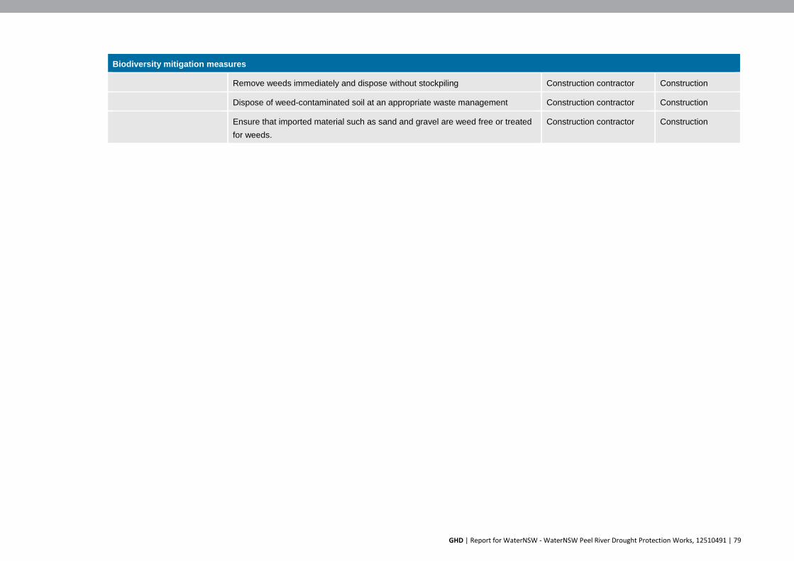
GHD | Report for WaterNSW - WaterNSW Peel River Drought Protection Works, 12510491 | 79
Biodiversity mitigation measures
Remove weeds immediately and dispose without stockpiling Construction contractor Construction
Dispose of weed-contaminated soil at an appropriate waste management Construction contractor Construction
Ensure that imported material such as sand and gravel are weed free or treated for weeds.
Construction contractor Construction
GHD | Report for WaterNSW - WaterNSW Peel River Drought Protection Works, 12510491 | 80
6.5 Land use and property
6.5.1 Existing Environment
The Dungowan Site (Lot 63, DP 755329) is zoned RU1 Primary Production under the Tamworth Regional Local Environmental Plan (2010). The site is owned by Tamworth Regional Council. The temporary pipeline is to be installed overland on an undeveloped ‘paper’ road owned by Tamworth Regional Council. Under-boring or open trenching would be used to cross Duri-Dungowan Road for the temporary pipeline. This land is also owned by Tamworth Regional Council.
The land use surrounding the Dungowan site is predominantly rural in nature. All surrounding properties are zones RU1 Primary Production, including the Dungowan Sports Ground, which is immediately to the south-east of the site.
The Dungowan Hotel is located to the north of the Peel River at 1572 Dungowan Road, on the corner of Duri-Dungowan Road and Nundle Road. The Dungowan Hotel provides accommodation and is approximately 300 metres to the north of the proposal site.
The closest residences to the proposal site are located on the north side of Nundle Road, approximately 450 metres to the north, and 550 metres north-west respectively. The location of the Dungowan proposal site in relation to surrounding land uses is shown in Figure 6-16.
There is one high security water customer on the Peel River between Dungowan and Tamworth. This site used 18 ML in the 2018-19 water year. There are six licensed water extraction pump sites on the Peel River downstream of Tamworth, operated by three users. Water from these pump sites is mainly used for agricultural land uses such as poultry, but also stock and domestic use.
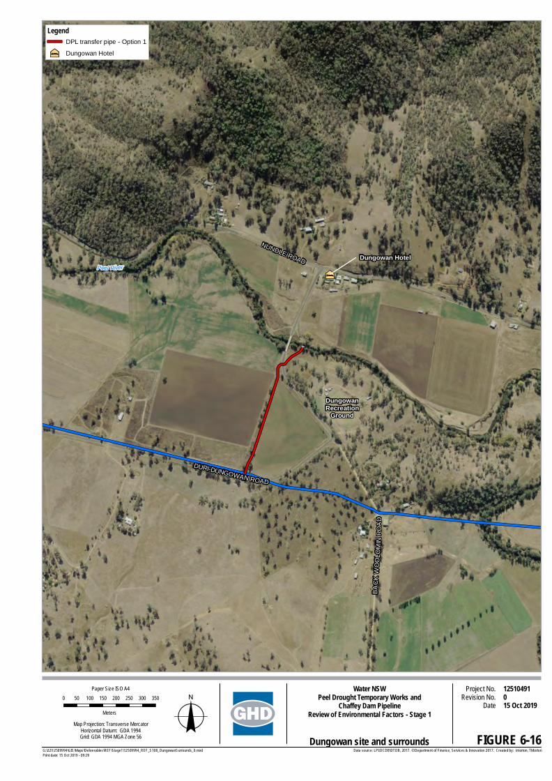
²
DURI-DUNGOWAN ROAD
NUNDLE ROAD
BA
CK
WO
OLO
MIN
RO
AD
DungowanRecreation
Ground
Dungowan HotelPeel River
FIGURE 6-16
0 50 100 150 200 250 300 350
Meters
Project No.Revision No. 0
12510491Date 15 Oct 2019
Water NSWPeel Drought Temporary Works and
Chaffey Dam PipelineReview of Environmental Factors - Stage 1
Map Projection: Transverse MercatorHorizontal Datum: GDA 1994Grid: GDA 1994 MGA Zone 56
Paper Size ISO A4
oData source: LPI:DCDB\DTDB, 2017. © Department of Finance, Services & Innovation 2017. Created by: tmorton, TMortonG:\22\12509994\GIS\Maps\Deliverables\REF\Stage1\12509994_REF_S108_DungowanSurrounds_0.mxd
Print date: 15 Oct 2019 - 09:29
LegendDPL transfer pipe - Option 1
²¶ Dungowan Hotel
Dungowan site and surrounds
GHD | Report for WaterNSW - WaterNSW Peel River Drought Protection Works, 12510491 | 82
6.5.2 Impact assessment
The proposal would involve constructing temporary infrastructure. This infrastructure would modify conditions at the site, but would not affect the long-term viability of the current or potential land uses in the immediate area.
If the do-nothing approach was adopted, the predicted cease to flow event that would occur in June 2020 would significantly affect habitat along the full length of the Peel River downstream of Chaffey Dam. These impacts are discussed in Sections 6.1 and 6.4.
The pool of water upstream of the temporary weir would fluctuate as releases are received and then pumped by the intake system. Impacts on water levels downstream of Dungowan as a result of Stage 1 works would be temporary until the Stage 2 pipeline is commissioned or the drought ceases. There would still be water downstream of Dungowan, albeit at lower volumes (refer to Section 6.1).
The installation of the water intake and temporary weir at Dungowan would temporarily restrict use of the existing 4WD crossing. Access to the 4WD crossing would be blocked for safety reasons during construction and operation of the proposal. The Duri-Dungowan Road Bridge over the Peel River is located less than 50 metres to the west of this crossing, and provides access across the Peel River. The proposal would not prevent movement across the Peel River.
The proposal would not affect the use of the Dungowan Sports Ground. The temporary pump station would be located to the west of the Dungowan Sports Ground on cleared vacant land. Parking and access at the Dungowan Sports Ground is on the eastern side, and would not be affected by the proposal. The temporary transfer pump station and pipeline would not affect the current use of the site. For the majority of its operation the proposal would have a minor impact on the amenity of the surrounding area due to noise impacts from the pumps at the temporary pump station.
The Dungowan Sports Ground is used for camping during January each year for the Tamworth Country Music Festival. Noise levels from the temporary pump station would be 32 dB(A) at night time at the western end of the Dungowan Sports Ground when the pumps are operating. This level is above the night time project noise trigger level of 30 dB(A) identified in the EPA’s Noise Policy for Industry. However, camping at the Dungowan Sports Ground is short-term and noise impacts at surrounding permanent residences would be below the NPI project noise trigger levels.
All feasible noise mitigation measures have been incorporated into the design of the pump station. Noise impacts and mitigation measures are described in Section 6.6.
Water availability
Water availability in the Peel River would be reduced by the proposal. There is one high security water customer on the Peel River between Dungowan and Tamworth. This property used a small volume of water, around 18 ML, in the 2018-19 water year. The existing Dungowan to Tamworth pipeline (DPL) crosses this property, and an existing connection to this pipeline is available. Use of this connection point would allow any environmental releases and tributary flows to pass downstream in the Peel River.
Downstream of Tamworth there are three water users that extract water from the Peel River from six extraction points. Water from the Peel River is used mainly for agricultural land use, such as poultry farming and stock watering. Some water is also used for domestic use.

GHD | Report for WaterNSW - WaterNSW Peel River Drought Protection Works, 12510491 | 83
Little water is expected to pass downstream of Tamworth after the installation of the proposal. WaterNSW has consulted with these water users and is working to develop alternative water sources. Alternatives being developed in include on-property storage tanks to be filled prior to the operation of the proposal, developing additional groundwater sources, and potentially using treated water from the Westdale Wastewater Treatment Plant (WWTP) for irrigation. Treated water from the WWTP is currently used for irrigation of 242 hectares of crops.
6.5.3 Mitigation measures
Mitigation measures for potential impacts on land use are provided in Table 6-6.
Table 6-6 Land use mitigation measures
Land use mitigation measures
Impact Mitigation measure Responsibility Timing
Disruption from construction activities
Consult with adjoining land owners regarding construction activities
Water NSW and construction contractor
Pre-construction
Construction
Use of land Rehabilitate areas disturbed during construction and decommissioning
Construction contractor Post-construction
Decommissioning
Water availability Develop in consultation with the NSW Government and relevant agencies alternate water sources for high security water users downstream of Tamworth. Alternatives may include:
On-site water storage tanks to be filled prior to operation of the proposal
Develop additional groundwater bores
Use of treated water from the WWTP for crop irrigation.
WaterNSW Pre-construction
Operation
6.6 Noise and vibration
6.6.1 Existing environment
In absence of any measured background noise data, the background noise level for the Dungowan site is adopted from the recommendations provided in the NPI (EPA, 2017). The NPI (EPA, 2017) provides a detailed methodology to determine the Rating Background Level (RBL). For the purposes of this assessment, the daytime RBL has been adopted as 35 dB(A) and the evening and night time RBL has been adopted as 30 dB(A). This is the minimum recommended RBL recommended in the NPI and is reflective of the rural nature of the area surrounding the site.

GHD | Report for WaterNSW - WaterNSW Peel River Drought Protection Works, 12510491 | 84
6.6.2 Noise management levels
Construction noise management level
Construction hours would be 7:00 am to 6:00 pm on Monday to Friday. Given the criticality of the works, construction would be required outside these standard hours. This would involve working on Saturday and Sunday from 8:00 am to 4:00 pm. The Interim Construction Noise Management Guidelines (DPIE-EES) (ICNG) indicates that work may be undertaken outside the standard construction hours under certain circumstances, including:
If it involves public infrastructure works
The extended hours will shorten the length of the project
If the works are supported by the affected community
Work would only occur outside the nominated working hours for the following reasons, and subject to prior approval by WaterNSW:
The delivery of oversized plant or structures that police or other authorities determine require special arrangements to transport along public roads
Emergency work to avoid the loss of life or damage to property, or to prevent environmental harm
Maintenance and repair of public infrastructure where disruption to essential services and/or considerations of worker safety do not allow work within standard hours
Public infrastructure works that shorten the length of the project and are supported by the affected community
Works where a proponent demonstrates and justifies a need to operate outside the recommended standard hours
WaterNSW would consult with affected stakeholders regarding the extended working hours.
Based on the ICNG, the Construction Noise Management Level (CNML) for residential receivers is the RBL plus 10 dB(A) during recommended standard hours and RBL plus 5 dB(A) outside of recommended standard hours. The highly noise affected CNML represents the point above which there may be strong community reaction to noise. Table 6-7 shows the CNML for residential receivers. Table 6-8 shows the CNML for other types of receivers.
Table 6-7 Construction noise management levels - residential
Receptor Type RBL LA90 Construction noise management levels LAeq
Noise affected level Highly noise affected Residential (During recommended standard hours)
35 dB(A) 45 dB(A) 75 dB(A)
Residential (Outside recommended standard hours)
30 dB(A) 35 dB(A) N/A

GHD | Report for WaterNSW - WaterNSW Peel River Drought Protection Works, 12510491 | 85
Table 6-8 Construction noise management level - other
Receptor Type Construction noise management levels LAeq
(when properties in use)
Commercial - Offices and retail outlets 70 dB(A) – External level
Industrial 75 dB(A) – External level
Educational institutions 45 dB(A) – Internal level
Places of worship 45 dB(A) – Internal level
Active recreation areas 65 dB(A)
Operational noise
As the Dungowan site is located in a rural setting, the existing noise environment is generally quiet, particularly at night. The NPI provides guidance on the assessment of industrial noise sources from activities listed in Schedule 1 of the Protection of the Environment Operations Act 1997 (POEO Act) and regulated by the EPA operational noise impacts. The NPI has two specific noise requirements – Intrusive Noise Level and Project Amenity noise level.
The intrusiveness of an industrial noise source may generally be considered acceptable if the level of noise from the source (represented by the LAeq descriptor), measured over a 15 minute period, and does not exceed the background noise level by more than 5 dB when beyond a minimum threshold. This intrusiveness noise level seeks to limit the degree of change a new noise source introduces to an existing environment. Intrusiveness noise levels are not used directly as regulatory limits. They are used in combination with the amenity noise level to assess the potential impact of noise, assess reasonable and feasible mitigation options and subsequently determine achievable noise requirements.
To limit continuing increases in noise levels from application of the intrusiveness level alone, the ambient noise level within an area from all industrial noise sources combined should remain below the recommended amenity noise levels specified in Table 2.2 of the NPI where feasible and reasonable. The recommended amenity noise levels are aimed at protecting against noise impacts such as speech interference, community annoyance and some sleep disturbance. The recommended noise levels represent the objective for total industrial noise at a receiver location, whereas the project amenity noise level represents the objective for noise from a single industrial development at a receiver location.
Table 6-9 provides the Intrusive Noise Level. The Amenity Noise Level is presented in Table 6-10.
Table 6-9 Intrusive noise criteria
Noise Sensitive Receiver Time of daya Minimum RBL for the Proposed Development,
LA90,15min dB(A)
Project Specific Intrusive Noise Criteriab,
LAeq,15min dB(A) Residential Day 35 40
Evening 30 35 Night 30 30
aNote: Time of day is defined as follows: Day – 7 am to 6 pm Monday to Saturday and 8 am to 6 pm on Sundays and public holidays ; Evening - 6 pm to 10 pm every day; Night – 10 pm to 7 am on Monday to Saturday and 10 pm to 8 am on Sunday and Public holidays. bProject intrusive noise criteria is calculated as the measured RBL + 5 dB

GHD | Report for WaterNSW - WaterNSW Peel River Drought Protection Works, 12510491 | 86
Table 6-10 Amenity noise levels
Noise Sensitive Receiver Time of dayb Minimum RBL for the Proposed Development,
LA90,15min dB(A)
Project Specific Intrusive Noise Criteriac,
LAeq,15min dB(A) Residential - Rurala Day 50 48
Evening 45 43
Night 40 38
aConsidering receiver category as “Urban” residential.
bNote: Time of day is defined as follows: Day – 7 am to 6 pm Monday to Saturday and 8 am to 6 pm on Sundays and public holidays ; Evening - 6 pm to 10 pm every day; Night – 10 pm to 7 am on Monday to Saturday and 10 pm to 8 am on Sunday and Public holidays. cProject amenity noise level (ANL) is Rural ANL minus 5 dB(A) plus 3 dB(A) to convert from a period level to a 15-minute level.
The noise trigger level is the lower (that is, the more stringent) value of the project intrusiveness noise level and project amenity noise level. Table 6-11 presents a summary of the project noise trigger levels, to assess the noise emission from the proposed development at the nearby noise sensitive receivers.
Table 6-11 Noise trigger level
Receiver type
Time of day Intrusive Noise Criteria, LAeq,15min
dB(A)
Project Amenity Noise Level (ANL)
Criteria,
LAeq,15min dB(A)
Project Noise Trigger
Levela, LAeq,15min dB(A)
Residential
Day 40 48 40
Evening 35 43 35
Night 30 38 30
aProject noise trigger level is the lowest of intrusive noise criteria and the project amenity noise level.
The NPI noise trigger levels provide an objective for assessing a proposal and are not mandatory limits required by legislation. The project noise trigger levels assist the regulatory authorities to establish licensing conditions. Where project noise trigger levels are predicted to be exceeded, feasible and reasonable noise mitigation strategies should be considered. In circumstances where noise criteria cannot be achieved, residual noise impacts are used to assess noise impacts and manage noise from the site in negotiation between the regulatory authority and community. The regulatory authority then sets statutory compliance levels that reflect the achievable and agreed noise limits from the development. Intrusive noise levels are only applied to residential receivers (residences). For other receiver types identified in Table 2.2 of the NPI, only the amenity levels apply.

GHD | Report for WaterNSW - WaterNSW Peel River Drought Protection Works, 12510491 | 87
6.6.3 Impact assessment
Construction noise
The impacts associated with construction noise would be short term and limited to the operation of construction equipment at the Dungowan site. Table 6-12 provides a list of typical construction equipment, and their associated sound power levels at the source (within one metre). The SWL is the combined sound power level if all items of equipment are operating simultaneously.
Table 6-12 Construction equipment and relevant sound power levels, dB(A)
Equipment required Equipment SWL, dB(A) Scenario SWL dB(A)
Generator 99
116 Excavator 104
Delivery Truck 115
Mobile Crane 101
The construction noise level is likely to be within the recommended CNML noise affected level for distances greater than 240 metres between the construction site and the affected receiver. There are no residences within 240 metres of the construction site. Noise mitigation measures are provided in section 6.6.4 to minimise potential construction noise impacts at nearby noise sensitive areas.
Vibration impact assessment
Construction would result in a short-term increase in localised vibration levels, as energy from equipment is transmitted into the ground and transformed into vibration, which attenuates with distance. The magnitude and attenuation of ground vibration is dependent on a range of factors including the method of energy transfer, the vibration frequency and type and the characteristics of the ground and surrounding topography. Due the distance of the proposal site to nearby sensitive receivers, vibration impacts from the construction of the proposal is unlikely. Vibration during construction is unlikely to impact on the nearby bridge.
Operational noise
Operational noise from the pump station has the potential to noise sensitive receivers (the nearest residence is 450 metres away and the Dungowan Hotel is 300 metres away). The pumps and diesel engine would run intermittently to maintain a minimum water level. The duration of pumping would vary. Similarly the time of day that the pumps would operate would vary from daytime to night time depending on the water level.
Noise modelling shows that operation of the pump station in the absence of noise control measures would exceed the guideline level. Noise control measures were then modelled and compared to the baseline. The control measures for the proposed pump station are provided in Table 6-14.
The noise modelling shows the significant reduction in noise levels after the application of noise control measures and this is summarised in Table 6-13. The modelling shows that the application of the control measures would allow the proposal to operate within the NPI criteria project trigger level at night time.

GHD | Report for WaterNSW - WaterNSW Peel River Drought Protection Works, 12510491 | 88
Table 6-13 Predicted noise level from proposed pump station
Noise sensitive receiver location Approximate
distance from pump
installation
Predicted noise level – without noise
control measures
Predicted noise level
– with noise control
measures
NPI criteria (project noise
trigger level) at night, dB(A)
Residence/hotel to the north 300 m 71 30
30 Resident to the north-west 450 m 58 30 Resident to South-East 550 m 58 20 Resident to South-West 875 m 58 20 Resident to West 670 m 60 21
Figure 6-17 shows the noise contours under the baseline conditions with no noise control measures in place. The expected noise exceeds the NPI trigger for night time.
Figure 6-18 shows the noise contours after the application of the noise control measures. The noise control measures would allow the proposed pump station to operate within the NPI trigger level for night time. Sensitive receivers are marked with the circular symbol. Numbers are shown in dB(A).
Figure 6-17 Operation noise contours - baseline

GHD | Report for WaterNSW - WaterNSW Peel River Drought Protection Works, 12510491 | 89
Figure 6-18 Operation noise contours – application of noise controls
The Dungowan Sports Ground is used for camping during January each year for the Tamworth Country Music Festival. Noise levels from the temporary pump station would be 32 dB(A) at night time at the western end of the Dungowan Sports Ground when the pumps are operating. This level is above the night time project noise trigger level of 30 dB(A) identified in the EPA’s Noise Policy for Industry. However, camping at the Dungowan Sports Ground be short-term and noise impacts at surrounding permanent residences would be below the NPI project noise trigger levels.

GHD | Report for WaterNSW - WaterNSW Peel River Drought Protection Works, 12510491 | 90
6.6.4 Mitigation measures
Mitigation measures for potential noise impacts are provided in Table 6-14.
Table 6-14 Noise mitigation measures
Noise mitigation measures
Impact Mitigation Responsibility Timing
Construction noise Construction activities that generate significant noise would not take place within 250 metres of a residence.
Construction contractor
Construction
Staff training:
All personnel working at the site would be made aware of their responsibilities in minimising noise.
When not in use, vehicles and machinery would be turned off.
Where practical, machines would be operated at low speed or power. Haulage and delivery trucks to limit compression braking and heavy throttling in the area. They would be switched off during loading and unloading operations.
Construction contractor
Construction
Construction hours:
Works to be carried out where possible during daylight work hours only (i.e. 7.00 am to 6.00 pm Monday to Friday; 8.00 am to 4.00 pm Saturday and Sunday).
Construction contractor
Construction
Equipment selection:
Use quieter and less vibration emitting construction methods/equipment where reasonable and feasible.
Minimise the use of tonal reversing beepers on mobile plant. It is recommended to use equipment installed with broadband reversing alarms instead.
Where feasible, select silenced compressors, silenced jackhammers and damped bits where possible.
Construction contractor
Construction

GHD | Report for WaterNSW - WaterNSW Peel River Drought Protection Works, 12510491 | 91
Noise mitigation measures
Community engagement:
Residences within 1150 metres of the proposed works would be notified of the construction details of the project. This would occur at least two weeks prior to construction.
Contact details for complaints and information would be provided.
In the unlikely event that a noise or vibration complaint is received, it would be responded to within 24 hours.
Complaints and response to complaints would be documented and documents kept for future reference.
Construction contractor
Construction
Operation of the pump station
An acoustic enclosure having two larger sides of the enclosure and the roof built with solid partition wall construction. The other two sides of the enclosure installed with acoustic enclosure for ventilation. The pump station installation is considered installed on a level concrete platform with appropriate vibration isolation.
Construction contractor
Construction
The solid part of the enclosure is considered to be constructed of a lightweight wall having minimum 18 mm compressed fibre cement sheet (mass 33 kg/m2) on the external side and installed on a 92 mm steel stud, and a 16 mm moisture resistant fire-rated plasterboard (mass 12.5 kg/m2) on the internal side. Insulation in the cavity should be minimum 75 mm thick and having a density of 80 kg/m3 (i.e. Bradford Fibretex 450 or equivalent)). This wall panelling system is expected to provide a minimum sound insulation rating of Rw 51 dB.
Construction contractor
Construction
Acoustic insulation should be installed/fixed to the internal side of the solid walls and roof of the enclosure. The insulation should be minimum 75 mm thick and have a density of minimum 14 kg/m3.
The acoustic louvre is considered to have the following minimum acoustic specification. Acoustically suitable louvres can be found from manufacturers such as Acran, Flexshield and IAC. etc.
Construction contractor
Construction

GHD | Report for WaterNSW - WaterNSW Peel River Drought Protection Works, 12510491 | 92
Figure 6-19 Proposed noise control measures – acoustic enclosure
Figure 6-20 Proposed noise control measures - solid wall construction (larger side walls and roof)
6.7 Traffic and access
6.7.1 Existing environment
The proposal site is located in a rural area, surrounded by large properties with low density rural housing. The proposal site is accessed off Duri-Dungowan Road, just to the west of its intersection with Back Woolomin Road. To the north of the site, across the Peel River, Duri-Dungowan Road joins Nundle Road, which is the main connecting road to Tamworth. The roads surrounding the proposal site at Dungowan experience traffic typical of rural roads.
Solid roof and larger side walls
75 mm Acoustic Insulation, 14
Acoustic louvre (as per
specification)
Diesel exhaust connected to
exhaust

GHD | Report for WaterNSW - WaterNSW Peel River Drought Protection Works, 12510491 | 93
6.7.2 Impact assessment
Access to the work sites would be via sealed roads leading from Tamworth. Construction of the proposal would produce temporary impacts to local traffic conditions. Access to surrounding properties would be maintained during construction, however minor interruptions to access may be experienced during delivery of construction equipment and material.
For the construction and decommissioning phases of the proposal, a temporary works compound would be established to the south of the proposal site, on TRC land off Duri-Dungowan Road. Figure 6-21 shows the indicative location of this temporary works compound.
Construction is planned for a four week period. During construction equipment and material would be delivered by large trucks, most likely semi-trailers. Construction equipment is likely to include equipment such as cranes, excavators and small tip trucks.
These trucks would likely travel from Tamworth, east via Nundle Road and then south via Duri-Dungowan Road to site. Additional vehicle movements, above existing traffic levels, are estimated to be about 10 large truck movements per day during peak mobilisation and de-mobilisation periods. This would have negligible impact on the local traffic network as the existing network of roads is suitable for use by the construction vehicles.
Access to the existing 4WD crossing of the Peel River would be blocked during construction and operation of the proposal for safety reasons. Access would be reinstated after the proposal is decommissioned.
The decommissioning phase would run for a similar timeframe to construction, and require a similar number of truck movements. Decommissioning would involve removing elements of the proposal such as the temporary works compound, water intake and temporary weir structure.
During operation, fuel tankers would be required to deliver diesel to the temporary pump station every three days. Light vehicles would be used for inspections and maintenance during operation. This would not impact local traffic conditions due to the low number of movements.

"ª!
DURI-DUNGOWAN ROAD
NUNDLE ROAD
DURI
-DUN
GO
WAN
RO
AD
BACKW
OOLOM
INRO
AD
DUNGOWANRECREATION
GROUND
FIGURE 6-21
0 20 40 60 80 100 120
Meters
Project No.Revision No. 0
12510491Date 15 Oct 2019
Water NSWPeel Drought Temporary Works and
Chaffey Dam PipelineReview of Environmental Factors - Stage 1
Map Projection: Transverse MercatorHorizontal Datum: GDA 1994Grid: GDA 1994 MGA Zone 56
Paper Size ISO A4
oData source: LPI:CDB?DTDB, 2017. Water NSW: Elevation\Heritage data, 2019. DBYD: Tesltra data, 2019. © Department of Finance, Services & Innovation 2017. Created by: tmorton, TMortonG:\22\12509994\GIS\Maps\Deliverables\REF\Stage1\12509994_REF_S104_Dungowan_TempWorksCompound_0.mxd
Print date: 15 Oct 2019 - 09:28
LegendDPL transfer pipe - Option 1
DPL
"ª! Pump
Indicative compound location
Dungowan temporary works compound
ÍB
WOOLOMIN
DUNGOWAN
CHAFFEY DAM
Regional locality

GHD | Report for WaterNSW - WaterNSW Peel River Drought Protection Works, 12510491 | 95
6.7.3 Mitigation measures
Mitigation measures for potential traffic impacts are provided in Table 6-15.
Table 6-15 Traffic and access mitigation measures
Traffic and access mitigation measures
Impact Mitigation Responsibility Timing
Property access WaterNSW would consult with surrounding property owners prior to construction commencing, and during construction when higher volumes of construction traffic is anticipated.
WaterNSW
Construction contractor
Pre-construction
Construction
Construction vehicles blocking roads
All construction vehicles would keep to designated site compounds and parking areas off public roads.
Construction contractor
Construction
Public safety around construction vehicles
Public access would be restricted as appropriate within the work zone.
Construction contractor
Construction
6.8 Geology and soils
6.8.1 Existing environment
The site is located within the Peel River alluvial floodplain. At the proposal site soils are predominantly light to medium clays, with non-sodic topsoil, and sodic sub-soils. No acid sulphate risks have been recorded at the site.
Contamination
A search of the EPA Contaminated Land Register was conducted on 16 August 2019. The search revealed two sites in the Tamworth Regional Council LGA that have been declared significantly contaminated land.
One site on Nundle Road has a current notice related to petroleum hydrocarbons (TPH/TRH) including Benzene, Toluene, Ethylbenzene and Xylenes (BTEX); and Naphthalene. This site is over 10 kilometres to the south of the proposal site and would not be affected by the proposal. The other site is on Goonoo Goonoo Road in South Tamworth over 30 kilometres from the proposal site.
6.8.2 Impact assessment
The proposal would disturb the surface of the ground during construction and decommissioning. Establishing site compounds, and transporting equipment and material between the compound and work sites would disturb the land surface, and potentially lead to erosion and sedimentation of the Peel River. Risks associated with erosion and sedimentation would be managed by the mitigation measures listed in Table 6-16.
Fuel and oil used in the construction equipment, and the ancillary facilities such as the pump station and fuel storage area, are potential sources of pollution. Any spills could potentially be transported into the river and impact water quality. Mitigation measures would be implemented to reduce the impact of spills. Risks associated with fuel and chemical spills would be managed by the mitigation measures listed in Table 6-16.

GHD | Report for WaterNSW - WaterNSW Peel River Drought Protection Works, 12510491 | 96
Excavation of the riverbank is required to install the temporary water intake structure. This could potentially lead to erosion and sedimentation of the Peel River.
The land surface would be disturbed during the establishment and use of the temporary construction compound, and pump station. Access between the compound and works site, such as transporting material and equipment would also disturb the land surface. Topsoil would be stripped, stored and stabilised next to the excavated bank, before being respread over the site to rehabilitate the area once decommissioned.
6.8.3 Mitigation measures
Mitigation measures for potential geology and soil impacts are provided in Table 6-16.
Table 6-16 Geology and soil mitigation measures
Geology and soil mitigation measures
Impact Mitigation Responsibility Timing
Erosion and sedimentation
Erosion and sediment controls would be installed prior to the commencement of works in accordance with Landcom (2006) Edition 4 ‘Managing Urban Stormwater: Soils and Construction’ (the Blue Book).
Construction contractor
Construction
Erosion and sediment control measures would remain in place until the area is stabilised to reduce potential surface water impacts. This would include applying measures to stabilise the topsoil stockpile.
Construction contractor
Construction
Weather forecasts shall be checked daily so that expected storm events can be considered for project planning in erosion and sediment management.
Construction contractor
Construction
Fuel and chemical spills
Spill kits would be available with each refuelling area and all staff would be trained in their use.
Construction contractor
Construction
Spill containment measures (such as drip trays) to be used where refuelling within 20 metres of a waterway is required, where possible refuelling greater than 20 metres from a waterway should occur.
Construction contractor
Construction
Soil removed from the creek bank to build the temporary coffer dam would be backfilled to the same location post construction. Topsoil would be stripped and stored next to the site for reuse during site rehabilitation.
Construction contractor
Construction
Construction of a bunded area for refuelling activities, including refilling the fuel storage tank.
Bunding would be constructed in accordance with Australian Standard AS 1940B1993: The Storage and Handling of Flammable and Combustible Liquids.
Construction contractor
Construction and operation

GHD | Report for WaterNSW - WaterNSW Peel River Drought Protection Works, 12510491 | 97
6.9 Air quality
6.9.1 Existing environment
Air quality in the proposed work areas would be typical of the surrounding rural region and generally of a high quality. Dust is the main factor that would contribute to a reduction in air quality, particularly given the prolonged drought. There are no significant point sources of air pollution in the vicinity of the proposed works.
The Dungowan Hotel is located about 300 metres north of the site at 1572 Dungowan Road, at the corner of Duri-Dungowan Road and Nundle Road. The Dungowan Hotel provides accommodation.
The closest residences to the proposal site are located on the north side of Nundle Road. The closest residences to the proposal site are approximately 450 metres to the north, and 550 metres north-west respectively.
The Bureau of Meteorology website shows that the prevailing wind in Tamworth is from the south-east, at over 20% of the time. The north-westerly is the next most frequent at over 10%. Figure 6-22 shows the Tamworth wind rose taken as measurements at 9am each day over a one year period.
The direction line on the wind rose also depicts the strength of the wind for each direction. The thin line represents calm winds, and the thick represents stronger winds. The Tamworth wind rose shows that calm winds from the south-east (shown as the thin line) occur the most often at over 10% of the time.
Source: Australian Government Bureau of Meteorology
Figure 6-22 Tamworth wind rose

GHD | Report for WaterNSW - WaterNSW Peel River Drought Protection Works, 12510491 | 98
6.9.2 Impact assessment
Construction
Construction at the site would generate dust from vehicles and construction equipment travelling across un-sealed areas. Emissions would be produced from vehicles and construction equipment.
Potential impacts on air quality would be temporary are unlikely to be significant. Impacts would be localised and limited to the construction and decommissioning periods, which would be for approximately four weeks. Exhaust emissions from vehicles, plant and machinery would be likely to have only a negligible impact on regional air quality. These emissions would be small in volume and readily dispersed by winds.
Operation
To operate the pump station at Dungowan using diesel powered pumps, approximately 3,600 litres per day of diesel would be required. The temporary pump station would be required for a period of six to 12 months.
Prevailing winds in the Tamworth area are from the south-east. The next most common wind conditions are in the opposite direction, coming from the north-west and blowing towards the south-east.
The nearest residential properties to the Dungowan site are approximately 450 metres to the north, and 550 metres north-west respectively. Under prevailing conditions, diesel emissions would travel and disperse for over 450 metres before reaching the nearest residential property to the north-west.
Short-term exposure to diesel fumes, such as non-occupational exposure, can irritate the eyes, nose, throat and lungs. Other symptoms include light-headedness, coughing and nausea. In the absence of controls at the source these short-term exposure impacts could be felt by residents in surrounding areas. Mitigation measures for potential impacts from diesel exhaust are provided in Table 6-17.
6.9.3 Mitigation measures
Mitigation measures for potential air quality impacts are provided in Table 6-17.
Table 6-17 Air quality mitigation measures
Air quality mitigation measures
Impact Mitigation Responsibility Timing
Dust generation Minimise works during windy periods to minimise dust generation
Construction contractor
Construction
Fuel emissions – construction
Adherence to appropriate Australian Standards
Construction contractor
Construction
Ensure all plant and equipment complies with part 4 of the Protection of the Environment Operations (Clean Air) Regulation 2002
Construction contractor
Construction
GHD | Report for WaterNSW - WaterNSW Peel River Drought Protection Works, 12510491 | 99
Air quality mitigation measures
Construction vehicles and equipment are to be suitably serviced within the six-month period prior to commencement of construction activities and all necessary maintenance undertaken during the construction period. The excessive use of vehicles and powered construction equipment is to be avoided
Construction contractor
Construction
All construction machinery is to be turned off when not in use to minimise emissions.
Construction contractor
Construction
Fuel emissions – operation
Exhaust scrubbing would be provided for the diesel pumps at the temporary pump station.
WaterNSW Operation
6.10 Socio-economic
6.10.1 Existing environment
The Tamworth Regional LGA covers an area of approximately 9,900 square kilometres. The Tamworth Regional LGA had a population of 59,600 (2016 Census), with about 50,000 living in the city of Tamworth.
The LGA includes a number of smaller population centres surrounding the city of Tamworth, including the towns of Manilla, Barraba, Nundle and Kootingal, as well as another 17 hamlets and villages (Tamworth Regional Council website). These small towns and villages access the larger centre of Tamworth for a range of educational, social, employment and medical services.
6.10.2 Impact assessment
The proposal is the first of a two stage strategy that would be implemented to slow the depletion of water stored in Chaffey Dam and improve Tamworth’s water security. The beneficial impacts of would be experienced by the city of Tamworth, together with towns and communities surrounding the city that rely on water stored in Chaffey Dam for their water supply. This benefit would be delivered to a population of nearly 60,000 people.
The benefits of Stage 1 would accrue to the wider area because it enables WaterNSW to slow the depletion rate while the Stage 2 works are being constructed. The proposal would allow WaterNSW to prioritise water delivery to communities for critical human water need over other needs. Critical human water need refers to the minimum amount of water needed to meet basic human needs. It also includes non-human needs, where a failure to meet these needs would cause too much damage to social, economic or national security.
The proposal would reduce river flows downstream of Chaffey Dam and particularly downstream of the temporary weir at Dungowan. This would affect landholders downstream who rely on river flows for stock and farm water supply, together with landholders who rely on the Peel River for wastewater discharge.
WaterNSW is consulting with affected landholders to identify alternative stock and domestic water supply arrangements so these can be implemented. Consultation has been undertaken (refer to section 5) with community and stakeholders to understand water allocation requirements.

GHD | Report for WaterNSW - WaterNSW Peel River Drought Protection Works, 12510491 | 100
6.10.3 Mitigation measures
Mitigation measures for potential socio-economic impacts are provided in Table 6-18.
Table 6-18 Socio-economic mitigation measures
Socio-economic mitigation measures
Impact Mitigation Responsibility Timing
Reduced water availability
Ongoing consultation with landholders and water users downstream of the proposal to minimise impacts of reduced water flow. Impacts would be managed and management measures communicated.
WaterNSW Operation
WaterNSW will continue to publish media releases and operations updates for the Peel River on its website:
https://www.waternsw.com.au/supply/drought-information/regional-nsw/peel-valley.
WaterNSW Operation
WaterNSW will continue to work with the NSW government and relevant agencies to implement drought contingency measures to make water available for critical human water needs to affected BLR and S&D users..
WaterNSW Operation
6.11 Visual amenity
6.11.1 Existing environment
Dungowan
Construction would take place in an area that contains an existing 4WD river crossing. The water intake works would also be within 50 metres and of the Duri-Dungowan Bridge that crosses the Peel River. Figure 6-23 shows the proposal site in relation to the existing 4WD crossing and bridge. The nearest sensitive receptor, in this case the Dungowan Hotel, is over 300 metres to the north and would not have direct views of the water intake works due to topography and intervening vegetation. Users of Dungowan Sports Ground would have limited views of the water intake structure due to the drop in topography and vegetation on the river bank.

DU
RI-D
UN
GO
WAN
RO
AD
FIGURE 6-23
0 10 20 30 40 50
Meters
Project No.Revision No. 0
12510491Date 15 Oct 2019
Water NSWPeel Drought Temporary Works and
Chaffey Dam PipelineReview of Environmental Factors - Stage 1
Map Projection: Transverse MercatorHorizontal Datum: GDA 1994Grid: GDA 1994 MGA Zone 56
Paper Size ISO A4
oData source: LPI:CDB\DTDB, 2017. Water NSW: Elevation\Vegetation data, 2019. © Department of Finance, Services & Innovation 2017. Created by: tmorton, TMortonG:\22\12509994\GIS\Maps\Deliverables\REF\Stage1\12509994_REF_S106_DungowanSite_0.mxd
Print date: 15 Oct 2019 - 09:29
LegendDPL transfer pipe - Option 1
4WD crossing
"ª! Pump
Dungowan site

GHD | Report for WaterNSW - WaterNSW Peel River Drought Protection Works, 12510491 | 102
6.11.2 Impact assessment
Construction
Temporary impacts to visual amenity would occur during construction in the immediate vicinity of the works. These impact would be due to the presence of construction vehicles and equipment at works sites. Visual impacts are not considered to be significant due to the four week construction period.
Operation - Dungowan
The temporary weir and intake structure at Dungowan would have minor visual impacts, limited to users of the Dungowan Sports Ground. There are no sensitive receptors that would have direct views of the temporary water intake works.
The temporary pump station would be visible from a broader area. The pump station would introduce an element with an industrial appearance in an otherwise rural setting. This visual impact would be temporary and of low significance given the small scale of the structure which is likely to be similar in appearance to those associated with agricultural buildings in the surrounding region.
6.11.3 Mitigation measures
Mitigation measures for potential visual amenity impacts are provided in Table 6-19.
Table 6-19 Visual amenity mitigation measures
Visual mitigation measures
Impact Mitigation Responsibility Timing
Construction visual impacts
Works area to be kept clean at all times Construction contractor
Construction
Area to be returned to pre-construction condition at the end of construction period
Construction contractor
Decommissioning
6.12 Waste management
6.12.1 Impact assessment
Waste produced during construction would be managed in accordance with the waste management hierarchy. This provides that waste avoidance is a priority, followed by reuse and recycling/reprocessing, with disposal as a last resort.
Small quantities of waste (packaging, material off cuts, consumables etc) would be generated during construction. The majority of construction activities would use pre-cast elements that are delivered to site which reduces the likelihood of substantial volumes of waste being generated. Vehicles and machinery would be serviced off-site, other than minor repairs following breakdown.
Significant volumes of liquid wastes, including oils or fuels are unlikely to be generated during construction. Liquid and non-liquid waste would be assessed for reuse potential in accordance with the EPA’s general resource recovery exemptions before considered for disposal. If no reuse potential exists, the waste would be classified and managed in accordance with the Waste Classification Guidelines (EPA, 2014).

GHD | Report for WaterNSW - WaterNSW Peel River Drought Protection Works, 12510491 | 103
Domestic waste generated by construction personnel would be collected in separate waste bins for collection by a licensed contractor. Material used to construct the water intake and temporary weir would be used to reinstate the bank after decommissioning, or would be removed for later re-use. This material would not be disposed to land fill off-site.
The proposal is unlikely to involve activities that pollute land or lead to environmental concerns associated with storing, transporting or handling waste. All waste would be classified and disposed of in accordance with the Waste Classification Guidelines (EPA, 2014).
6.12.2 Mitigation measures
Mitigation measures for potential waste impacts are provided in Table 6-20.
Table 6-20 Waste mitigation measures
Waste mitigation measures
Impact Mitigation Responsibility Timing
Construction, operation and decommissioning waste
All waste generated by the proposal would be classified and disposed of in accordance with the NSW Waste Classification Guidelines Part 1: Classifying Wastes (DECCW 2008).
Construction contractor
Construction
Resource management hierarchy principles are to be followed:
Avoid unnecessary resource consumption as a priority
Avoidance is followed by resource recovery (including reuse of materials, reprocessing, and recycling and energy recovery)
Disposal is undertaken as a last resort.
Construction contractor
Construction
All waste material would be removed from site once the works have been completed.
Construction contractor
Construction
Working areas are to be maintained, kept free of rubbish and cleaned up at the end of each working day.
Construction contractor
Construction
If the contractor is working at the same location for more than one day, self-contained portable ablution and toilet facilities shall be provided, unless negotiated otherwise with WaterNSW. These facilities shall be located at least 20 metres from any natural or built drainage line or wetland. The toilet facilities would be pumped out and disposed offsite by a licensed provider.
Construction contractor
Construction

GHD | Report for WaterNSW - WaterNSW Peel River Drought Protection Works, 12510491 | 104
Waste mitigation measures
If any previously unidentified contamination (e.g. sheets of asbestos, discoloured soil, strong chemical or petrol odours, refuse or leachate) is discovered during works, works would halt and WaterNSW would be notified immediately to determine appropriate response measures.
Construction contractor
Construction
6.13 Cumulative impacts
6.13.1 Construction
Cumulative environmental impacts include the combined effect of individual impacts associated with the proposal, in addition to the impacts of other activities in the locality.
The Dungowan locality is rural in character, with agricultural land and the Dungowan Sports Ground surrounding the site. The proposal is unlikely to result in a cumulative impact from construction activities. Construction activities are unlikely to interact with impacts from other construction or land use activities to the point that cumulative impacts would accrue.
6.13.2 Operation
A range of actions have been taken to provide water for critical human need in the Tamworth area. The proposal has been developed in response to a Stage 4 critical drought / water shortage. This includes:
The proposal has been developed as a measure to secure critical water supplies for the immediate future in times of drought by reducing the depletion rate of Chaffey Dam. Stage 1 would remain in place until Stage 2 is commissioned.
The cumulative impact of proposal would be to conserve surface water supplies in Chaffey Dam to delay a cease to flow event in the Peel River. This is likely to lead to significant positive socio-economic and environmental outcomes compared to the do-nothing scenario that would produce a cease to flow event with no water available for the city of Tamworth or the Peel River beyond June 2020.

GHD | Report for WaterNSW - WaterNSW Peel River Drought Protection Works, 12510491 | 105
7. Environmental management 7.1 Construction environmental management plan
The proposal would be delivered in accordance with a comprehensive suite of environmental mitigation measures and controls that are designed to mitigate the potential environmental impacts. These measures would be documented in a CEMP and applied during construction and operation of the proposal.
The CEMP would describe safeguards and management measures identified in section 6 of the REF and any additional measures required by licences, permits or approvals that are required to construct the proposal. This would provide a framework for establishing how measures would be implemented and who would be responsible for their implementation.
The CEMP would be prepared prior to commencement of construction and be reviewed and endorsed by WaterNSW. The CEMP would be a working document, subject to ongoing change and updated as necessary.
The key objective of the CEMP would be to deliver and implement the environmental commitments made in the REF throughout the construction period, together with conditions imposed by any licences and approvals. The CEMP would include the following information:
Details of all positions and contact details of all key personnel
Audit and reporting program to ensure all actions/measures are implemented
Training requirements, including site induction requirements to ensure that all personnel understand the principles of environmental management
Emergency and incident response procedures
List of approvals to be obtained before work commences
Consultation requirements (government and community) and complaint handling procedures
Actions for meeting environmental objectives based on the mitigation measures identified in this REF and any statutory or regulatory obligations
Details of person responsible for the implementation of each action
7.2 Operational environmental management plan
The proposal would be operated by WaterNSW in accordance with procedures that apply to the remainder of its water supply network, including arrangements to implement temporary works during droughts. Specific measures that would be developed in consultation with relevant government agencies and implemented relate to:
Release of water for environmental maintenance flows
Water quality monitoring plan as indicated in sections 6.1.4.

GHD | Report for WaterNSW - WaterNSW Peel River Drought Protection Works, 12510491 | 106
8. Conclusion 8.1 Justification of the proposal
The current drought is the worst in recorded history. It is having severe effects on the security of water supply to the city of Tamworth and the surrounding area that supports a population of nearly 60,000 people.
The current drought is having a severe effect on the water storages in Chaffey Dam. Inflows to Chaffey Dam during the current drought period have been significantly lower than in previous drought periods, including the previous worst drought on record. In October 2019, Chaffey Dam’s storage dropped to 19% of capacity. If current drought conditions persist, and there is no significant in flows to the storage from rainfall, the storage in Chaffey Dam which is Tamworth’s water supply is predicted to run dry by June 2020. The proposal is the first of a two stage process that is needed to address both short-term and long-term water supply security for Tamworth.
WaterNSW, local water utilities (Councils) and DPIE-W, are jointly and individually planning and implementing projects to conserve water and provide long-term security for water supplies. This includes implementing temporary works to supply water to towns, communities and high security water users downstream of Chaffey Dam.
The do-nothing approach would result in Chaffey Dam being fully depleted by June 2020 in the absence of inflows. Stage 1 involves constructing temporary infrastructure and would extend the duration that water is stored in Chaffey Dam from June 2020 until October 2020. Stage 1 would improve short-term water security until Stage 2 is commissioned.
The proposal is justified as it would reduce the depletion rate and extend the duration that Chaffey Dam is able to provide water to Tamworth. The proposal would extend the available water supply to the Tamworth region in the time of record drought and is justified because it would prioritise water for critical human water needs.
The proposal is designed to:
Be cost effective by maximising the use of existing infrastructure and minimising the need to invest in new infrastructure.
Enable it to be constructed and commissioned within a short timeframe in response to the current drought, to provide time to enable Stage 2 to be constructed and commissioned.
Enable it to be decommissioned within a short timeframe.
Minimise environmental impacts by limiting construction to existing disturbed areas and enabling tributary flows to be passed downstream.
Section 8.2 demonstrates that the proposal is consistent with the principles of ecologically sustainable development (ESD).

GHD | Report for WaterNSW - WaterNSW Peel River Drought Protection Works, 12510491 | 107
8.2 Principles of ecologically sustainable development
8.2.1 Precautionary principle
The precautionary principle states that:
‘if there are threats of serious or irreversible environmental damage, lack of full scientific certainty should not be used as a reason for postponing measures to prevent environmental degradation’
Environmental assessments have been undertaken to prepare this REF to fully understand the potential environmental impacts with a high degree of certainty. The proposal is required to maintain water supply for critical human needs in the Peel River. The proposal would occur in a highly regulated river system. Potential environmental impacts have been assessed, and mitigation measures and safeguards are proposed to protect the environment.
The proposal has been designed to avoid environmental impact where practicable. Mitigation measures can be implemented to minimise impacts. No mitigation measures have been deferred due to a lack of scientific certainty. A water quality monitoring program would be implemented to monitor water quality and the response of the aquatic environment downstream of the Dungowan site.
The monitoring program would enable the direct impacts of the proposal to be monitored and allow the mitigation measures to be implemented according to the observed environmental responses. The proposal is therefore considered to be consistent with the precautionary principle.
8.2.2 Inter-generational equity
The principle of inter-generational equity states that:
‘the present generation should ensure that the health, diversity and productivity of the environment are maintained or enhanced for the benefit of future generations’
The proposal is unlikely to impact on natural or cultural features to a level that would compromise the health, diversity or productivity of the environment for future generations. The proposal would improve water quality in the immediate future. In combination with Stage 2 the proposal would secure water supply for the long-term of Tamworth and the surrounding area, thereby positively affecting future generations.
The proposal is temporary and would be decommissioned when Stage 2 is commissioned. It is unlikely to adversely impact on the health, diversity or productivity of the environment for future generations.
8.2.3 Conservation of biological diversity and ecological integrity
The principle of biological diversity and ecological integrity states that:
‘conservation of biological diversity and ecological integrity should be a fundamental consideration’
The proposal would have negligible direct impact on vegetation as only a very small amount vegetation may need to be removed to construct the Dungowan structure. The Peel River is a highly regulated system. Waterways have been impacted by the construction and operation of Chaffey Dam. The Peel River ecosystem has responded to and adapted to changes to flow regimes since the construction of Chaffey Dam.
Due to current drought conditions, the Peel River is predicted to cease to flow downstream of Chaffey Dam in June 2020 if there are no inflows to Chaffey Dam.

GHD | Report for WaterNSW - WaterNSW Peel River Drought Protection Works, 12510491 | 108
The proposal would have adverse biodiversity impacts as flows would be reduced downstream of the Dungowan site. These impacts however would be less severe than if the do-nothing approach is adopted and the cease to flow event occurs in June 2020 that affects the full length of the Peel River downstream of Chaffey Dam.
If adequate flows are not provided from Chaffey Dam releases, reduced flows to the Peel River downstream of Dungowan would result in water retreating into pools. In the absence of regular flows that allow these pools to overtop and flow downstream, water quality within those pools would decline. As the volume decreases water quality impacts would have the flow on effect on the quality and extent of habitat for biota. These adverse impacts would be limited to the sections that do not receive flows past the Dungowan water intake to allow overtopping and flows downstream.
Management measures would be implemented to minimise these adverse impacts. This includes managing environmental releases, and allowing water flows past the temporary water intake at Dungowan.
The Stage 1 works would have positive impacts by delaying a cease to flow event. In combination with Stage 2, the proposal has the potential to delay a cease to flow event that effects the full length of the Peel River downstream of Chaffey Dam. This would:
Extend the duration that aquatic habitat is maintained in the river, and the duration that fish are able to move between refuge habitat within the river compared to the do-nothing scenario
Reduce the risk of adverse water quality conditions developing compared to the do-nothing scenario
The beneficial biological impacts of deferring a cease to flow event in the Peel River are considered to outweigh the adverse impacts that would occur from the temporary intake structure at Dungowan.
A mitigation program is to be implemented to monitor water quality and the response of the aquatic environment along the Peel River. This would enable the direct impacts of the proposal to be monitored and allow for the mitigation measures to be implemented according to the observed environmental responses.
8.2.4 Appropriate valuation of environmental factors
The principle of improved valuation of environmental resources states that:
‘environmental factors should be included in the valuation of assets and services’
This principle relates to giving monetary values to environmental resources. The cost of environmental resources includes costs incurred to protect the environment. The safeguards imposed to minimise adverse impacts would result in economic costs to WaterNSW. The proposal has been designed to minimise adverse environmental impacts on the environment by implementing appropriate mitigation measures where impacts are likely.
The proposal would assist to deliver water in a safe and sustainable way for critical human need. These factors ensure that the development would conform to the principles of “ecologically sustainable development”.

GHD | Report for WaterNSW - WaterNSW Peel River Drought Protection Works, 12510491 | 109
8.3 Clause 228 factors
Clause 228 of the NSW Environmental Planning and Assessment Regulation 2000 describes what factors must be considered when assessing the impact of an activity on the environment. Table 8-1 provides a summary of the assessment of the requirements of Clause 228.
Table 8-1 Clause 228 matters
Clause 228 Factor Impacts
(a) Any environmental impact on a community?
The proposal would have minor, short term impacts on the community due to amenity-based impacts during construction, and during operation relating to noise and air quality. These impacts would be localised and the mitigation measures in section 7 of the REF would be implemented to minimise impacts.
Minor adverse
(b) Any transformation of a locality?
The proposal would not transform a locality because the works would be temporary and would be removed once the Stage 2 works are complete. The temporary works would be viewed in the context of the existing water supply infrastructure.
Minor adverse
(c) Any environmental impact on the ecosystem of the locality?
The proposal would result in both positive and adverse hydrological impacts within this highly regulated catchment. The proposal would have adverse ecological impacts as a result of reduced water flows downstream of Dungowan. These would be short term and temporary during the operation of Stage 1. The effects of the Stage 2 pipeline are addressed in a separate REF.
Through implementation of Stage 1, the water level would be reduced in the Peel River downstream of Dungowan. This may compromise the survival of some species in this waterway that require deeper water habitat.
In the absence of rainfall, the Peel River immediately downstream of Chaffey Dam would cease to flow in June 2020 if the proposal is not implemented as planned in November 2019. The adverse effects of this cease to flow event would result in the sections of Peel River downstream of the Dungowan structure ceasing to receive any water.
Moderate negative impact from temporarily reduced water availability.
Positive impact by delaying a cease to flow event in the case of the do-nothing scenario.

GHD | Report for WaterNSW - WaterNSW Peel River Drought Protection Works, 12510491 | 110
Clause 228 Factor Impacts
Potential impacts of this event would include declining water quality and quantity, and associated consequences such as fish kills and declining health of vegetation communities and terrestrial species due to water stress.
Under the proposal, discharges would be maintained in the section of the river between Chaffey Dam and Dungowan. This part of the river has higher quality habitat for species such as the Boorolong Frog and threatened fish including Southern Purple Spotted Gudgeon, Olive Perchlet and Eel-Tailed catfish. The proposal would extend the duration that refuge habitat is provided and reduce the risk of adverse water quality conditions developing within this section of the river. Flows from the proposed environmental releases of up to 30 ML over one day per week would pass the proposal site and continue downstream towards Tamworth. Any tributary flows would also be allowed to pass the proposal site. This would be beneficial compared to the do-nothing scenario.
(d) Any reduction of the aesthetic, recreational, scientific or other environmental quality or value of a locality?
The proposal would have a short term impact on the aesthetic and recreational value of the locality because construction would be required at Dungowan which adjacent to a public reserve. This impact would be temporary because construction would take four weeks to complete would affect a small portion of land adjacent to the reserve. The proposal is temporary and would be decommissioned once the Stage 2 pipeline is commissioned.
Minor
(e) Any effect on a locality, place or building having aesthetic, anthropological, archaeological, architectural, cultural, historical, scientific or social significance or other special value for present or future generations?
The proposal would not impact on any places of heritage significance.
Nil

GHD | Report for WaterNSW - WaterNSW Peel River Drought Protection Works, 12510491 | 111
Clause 228 Factor Impacts
(f) Any impact on the habitat of protected fauna (within the meaning of the National Parks and Wildlife Act 1974)?
The proposal would result in flows being reduced downstream of Dungowan. This would impact on the habitat of protected fauna. This has the potential to reduce the quality and quantity of water in downstream watercourses and may lead to fish kills. Platypuses are likely to be impacted through reduction of foraging habitat and lowering of water levels, making some existing burrows inaccessible.
Potential impacts on protected terrestrial and aquatic fauna downstream of Dungowan would be preferential to the cease to flow event that would occur in June 2020 under the do-nothing scenario. The proposal would allow water to remain in the river system for longer and provide refuge habitat.
The proposal would have a positive impact on protected terrestrial and some aquatic fauna by prolonging water in the Peel River and delaying a cease to flow event. The mitigation measures outlined in section 7 would be implemented to minimise the risk of adverse impacts.
Moderate negative impact from reduced water availability.
Positive impact by delaying a cease to flow event in the case of the do-nothing scenario.
(g) Any endangering of any species of animal, plant or other form of life, whether living on land, in water or in the air?
The proposal would result in reduced flows downstream of Dungowan. This would impact on flora, fauna and ecological communities. This has the potential to result in reduced water quality and quantity in downstream, and may lead to fish kills. The reduced water level may compromise the existence of some aquatic fauna in the Peel River downstream including Murray Cod and other larger fish species and platypuses.
Potential impacts on protected terrestrial and aquatic fauna downstream of Dungowan would be preferential to the cease to flow event that would occur in June 2020 under the do-nothing scenario.
The proposal would have a positive impact on protected terrestrial and most aquatic fauna by delaying a cease to flow event. The mitigation measures outlined in section 7 would be implemented to minimise the risk of adverse impacts.
Moderate negative impact from temporarily reduced water availability.
Positive impact by delaying a cease to flow event in the case of the do-nothing scenario.

GHD | Report for WaterNSW - WaterNSW Peel River Drought Protection Works, 12510491 | 112
Clause 228 Factor Impacts
(h) Any long-term effects on the environment?
The proposal is unlikely to have long-term effects on the environment as it would be temporary and would be decommissioned once the Stage 2 pipeline is commissioned. The ecosystem downstream of the affected structures would recover over time once higher flow conditions return.
Potential impacts on protected terrestrial and aquatic fauna downstream of Dungowan would be preferential to the cease to flow event that would occur in June 2020 under the do-nothing scenario.
Minor
(i) Any degradation of the quality of the environment?
The proposal has the potential to result in poor water quality developing in residual pools downstream of Dungowan. Water quality would be monitored and mitigation measures would be implemented to reduce the risk of declining water quality resulting in impacts such as fish kills.
Minor
(j) Any risk to the safety of the environment?
The proposal is unlikely to result in risks to the safety of the environment provided the recommended mitigation measures are implemented. The proposal is temporary and construction would be limited to localised areas.
Minor
(k) Any reduction in the range of beneficial uses of the environment?
The proposal is unlikely to have any reduction in the range of beneficial uses of the environment compared to the do-nothing scenario. The proposal is temporary and would be decommissioned once the Stage 2 pipeline is commissioned. Construction would be short term and limited to the Dungowan sites.
Nil
(l) Any pollution of the environment?
The proposal is unlikely to cause any pollution of the environment provided the recommended mitigation measures are implemented.
Nil

GHD | Report for WaterNSW - WaterNSW Peel River Drought Protection Works, 12510491 | 113
Clause 228 Factor Impacts
(m) Any environmental problems associated with the disposal of waste?
The proposal is unlikely to cause any environmental problems associated with the disposal of waste.
All waste would be managed and disposed of in accordance with the Waste Classification Guideline (EPA, 2014).
Minor
(n) Any increased demands on resources (natural or otherwise) that are, or are likely to become, in short supply?
The proposal is a temporary measure that would prioritise water for critical human water needs and would be decommissioned once the Stage 2 pipeline is commissioned. The proposal would not impact on any other resources that are, or likely to become, in short supply.
Minor change to adverse impacts downstream relative to the do-nothing scenario
(o) Any cumulative environmental effect with other existing or likely future activities?
The proposal is temporary and would be decommissioned once the Stage 2 pipeline is commissioned. In combination with the Stage 2 works, the proposal would prevent a cease to flow event under the do-nothing scenario. The environmental impacts of a cease to flow event would be more significant and long-term in comparison to the proposal. The proposal would delay the cease to flow event.
Minor change to adverse impacts downstream relative to the do-nothing scenario
(p) Any impact on coastal processes and coastal hazards, including those under projected climate change conditions?
The proposal would not affect or be affected by any coastal processes or hazards.
Nil
GHD | Report for WaterNSW - WaterNSW Peel River Drought Protection Works, 12510491 | 114
8.4 Conclusion
The REF assesses the potential impacts of the proposal. It has been prepared in accordance with Part 5 of the EP&A Act and considers the factors listed in clause 228 of the EP&A Regulation (refer to section 8.3).
The REF documents the potential environmental impacts of the proposal, considering both potential positive and negative impacts. It recommends management and mitigation measures to protect the environment where required.
There would be short term, temporary, minor adverse impacts during construction. The main issues would be associated with impacts on:
Soil and water due to erosion and sedimentation
Air quality due to dust from exposed surfaces
Biodiversity due to disturbance from machinery and equipment
Noise due to the operation of machinery and equipment
Traffic and access to neighbouring properties
Operational impacts would be temporary as the proposal would be decommissioned following commissioning of Stage 2.
The main impacts associated with operation of the proposal would include:
Noise from the operation of the temporary pump station
Air quality from the operation of the temporary pump station
The proposal provides a significant benefit to the Tamworth community dependent on water supplied from Chaffey Dam for critical human water needs by prolonging the availability of the remaining dam reserves and extending the predicted cease to flow date which increases the likelihood of inflows to Chaffey Dam.
Overall, potential negative impacts associated with the proposal can be adequately managed by implementing the mitigation measures in section 7. The beneficial impacts are considered to outweigh the adverse impacts. The proposal is unlikely to have a significant impact on the environment and does not require an EIS to be prepared, or a referral to the Commonwealth under the EPBC Act.
If the scope of work or study area assessed in this REF change, WaterNSW would determine whether additional environmental assessment is needed to ensure that their obligations under the EP&A Act are addressed.

GHD | Report for WaterNSW - WaterNSW Peel River Drought Protection Works, 12510491 | 115
9. References Davies, P. E., et al. (2012). Sustainable Rivers Audit 2: The ecological health of rivers in the Murray–Darling Basin at the end of the Millennium Drought (2008–2010). Volume 3. Prepared by the Independent Sustainable Rivers Audit Group for the Murray–Darling Basin (ISRAG). Murray-Darling Basin Authority, Canberra.
DECC (2007). White Box -Yellow Box-Blakely's Red Gum Woodland. Identification Guidelines for Endangered Ecological Communities. NSW Department of Environment and Climate Change, Sydney.
DECC (2008). Hygiene protocol for the control of disease in frogs. Information Circular Number 6. NSW Department of Environment and Climate Change, Sydney South.
DoE (2019). Litoria booroolongensis in Species Profile and Threats Database. Department of the Environment, Canberra.
DPI (2013). Policy and guidelines for fish habitat conservation and management. Update 2013. NSW Department of Primary Industries.
DPI (2017). NSW Recreational Freshwater Fishing Guide 2016-17. NSW Department of Primary Industries.
DPI (2014) Primefact 176: Olive Perchlet (western population) - Ambassis agassizii. https://www.dpi.nsw.gov.au/__data/assets/pdf_file/0008/635876/PUB12-10-Primefact-176-Western-Olive-Perchlet-Ambassis-agassizii.pdf
NSW Scientific Committee (2011). "Final Determination: White Box Yellow Box Blakely's Red Gum Woodland." from https://www.environment.nsw.gov.au/topics/animals-and-plants/threatened-species/nsw-threatened-species-scientific-committee/determinations/final-determinations/2011-2012/white-box-yellow-box-blakelys-red-gum-woodland-minor-amendment-determination.
TSSC (2019). Listing and Conservation Advice - White Box – Yellow Box – Blakely’s Red Gum Grassy Woodland and Derived Native Grassland. Threatened Species Scientific Committee, Canberra.

GHD | Report for WaterNSW - WaterNSW Peel River Drought Protection Works, 12510491
Appendices

GHD | Report for WaterNSW - WaterNSW Peel River Drought Protection Works, 12510491
Appendix A – Biodiversity

Assessments of Significance
Environment Protection and Biodiversity Conservation Act 1999
Booroolong Frog
The Booroolong Frog (Litoria booroolongensis) is listed as an endangered species under both the EPBC Act and BC Act. The species relies on permanent streams with a multitude of characteristics including rock bank structures, riffles, rapids and slow-flowing sections. A population is known to occur in the Peel River upstream of Chaffey Dam.
The Booroolong Frog requires submerged rock crevices and slow-flowing connected or isolated pools for breeding. Breeding occurs in spring and early summer. Tadpoles metamorphose in late summer to early autumn. Adult frog populations have been identified in highly modified sections of streams, including those with a lack of native vegetation, open to stock access and have artificial structures such as weirs. Populations fluctuate depending on seasonal conditions, and severe drought can lead to their decline.
The proposal includes a temporary weir, water intake structure and pipeline transfer works in the Peel River at Dungowan. The water intake structure would provide a pool of water around a screened suction intake. The water intake has been designed to discourage intake of tadpoles by using a 3 mm mesh in addition to a reduced flow-velocity into the intake itself. The Booroolong Frog attaches eggs to rocks and could potentially breed in this area if a population is present. Eggs would be unlikely to enter the intake, unless deposited in very close proximity.
The temporary weir would create a pool of water upstream, which will potentially increase habitat for the species, if present at this location. A small section of potential habitat at the proposal site would be reduced from the construction and operation of the proposal. The small amount of habitat that would be impacted by the proposal would be offset by the creation of pooling habitat upstream of the temporary weir.
The proposal will temporarily alter the current flow regimes of the Peel River through a reduction in water flow from 44 ML/day to a regulated environmental pulse flow releases equivalent to 30 ML/week. Without implementation of this proposal, the Peel River would potentially run dry prior to the 2020 breeding season, however the proposal would extend the presence of water in the river until July 2021. These reduced flows would be delivered to provide the most suitable environmental outcome. Regulated pulse flows would reduce evaporative loss and allow water to remain in the river to connect refuge pools and provide flows to Tamworth. The proposal would be in place for six to twelve months, which is a maximum of one breeding season.

Significant Impact Guidelines 1.1 Environment Protection and Biodiversity Conservation Act 1999 (Booroolong Frog (Litoria booroolongensis)-Listed as an endangered species
Significant impact criteria Response
An action is likely to have a significant impact on a critically endangered or endangered species if there is a real chance or possibility that it will: lead to a long-term decrease in the size of a population
A large population of Booroolong Frog has been recorded upstream of Chaffey Dam. The Peel River upstream of the proposal site provides good quality habitat due to the species preference for the headwaters of rivers with isolated pools, rather than large, deep, fast flowing sections, such as are present at Dungowan. While the Booroolong Frog has not been recorded downstream of Chaffey Dam (NWES, 2015; NWES, 2009) there is potentially suitable habitat for the species between the Dam and Dungowan. Existing regulation of flows below Chaffey Dam may have already led to local extinctions of the species below the dam as no evidence of the species was found in these reaches during surveys for the conservation status of the species in the Namoi Catchment (NWES, 2015; NWES, 2009). Targeted surveys for the species have not been undertaken for this proposal given the timing of the proposal has not coincided with the activity period for the species. The Booroolong Frog relies on permanent water; however populations fluctuate in response to seasonal conditions. The proposal will temporarily alter the current flow regimes of the Peel River through a reduction in water flow from 44 ML/day to a regulated environmental flow releases equivalent to 30 ML of water weekly, released in pulses. These flows will be delivered to provide the most suitable environmental outcome. This would reduce evaporative loss and allow water to remain in the river to connect refuge pools and provide flows to Tamworth. As noted above, without implementation of this proposal, the Peel River would potentially run dry prior to the 2020 breeding season, however the proposal would extend the presence of water in the river until July 2021. The deeper areas of the downstream reaches between the Dungowan and Jewry Street are likely to be maintained but would experience a retraction in area and water levels. The reductions in water level in the larger pools may make these more suitable for breeding, potentially replacing some of the other lost habitat areas. The creation of a pool upstream of the temporary weir may also provide additional breeding habitat. There is also likely to be a reduction in potential refuge and foraging habitat within fringing vegetation cover such as ferns, sedges or grasses. The distance between foraging habitat on stream banks and the main channel of the Peel River may widen, as water flow and extent decrease in between environmental flow releases. As noted above, the species has not been recorded in this area, and existing regulation of the river may have already led to extinction of populations downstream of the dam.

Significant impact criteria Response
Downstream of the proposal site, water flows would be modified and volumes would be reduced. Shallow ponds would dry out. These pools would represent potential breeding habitat for the Booroolong Frog, if a population occurs in this area. Reduced water flows may also disconnect pools and remove riffles that provide habitat for this species. The proposal would be in place for between six and twelve months. This would be a maximum of one full breeding season. The proposal is unlikely to lead to a decrease in the size of the Booroolong population. There is no evidence of the species below Chaffey Dam. The proposal will limit flows down the river, which would reduce the area of potential breeding habitat and could reduce water quality in these locations. There would be no direct impact on the known population upstream of Chaffey Dam as a result of the proposal.
reduce the area of occupancy of the species
There would be no direct impact on the known population upstream of Chaffey Dam as a result of the proposal. The reduction in water flows downstream from Chaffey Dam has the potential to temporarily reduce the area of occupancy for this species (should they occur) due to a reduction in instream habitat. Drought conditions would lead to the river running dry and the proposed drought relief pipeline and environmental flows should extend the period in which water remains in the Peel River, potentially maintaining habitat for the species if present.
fragment an existing population into two or more populations
There would be no fragmentation of habitat of the known population upstream of Chaffey Dam as a result of the proposal. Given the lack of evidence of the species below the dam, it is thought that historical regulation of the river may have already led to the extinction of local populations below the dam (NWES, 2015). Potential habitat of the Booroolong Frog is unlikely to be fragmented by the proposal. The species often occurs in isolated pools. The temporary weir would allow stream flow downstream, and would not block movement along the creek banks. The proposal would be in place for between six and twelve months. The proposal site would be reinstated after the infrastructure is removed. Any fragmentation would be for a maximum of one breeding season.
adversely affect habitat critical to the survival of a species
The recovery plan for the Booroolong Frog (OEH, 2012) has identified rocky sections of permanent streams occupied by the species as critical habitat for the species. Any action that reduces stream permanency (e.g. pumping water) or results in loss of rock crevices (e.g. smothering by weeds or sedimentation), is likely to threaten the persistence of local populations of this species.

Significant impact criteria Response
There would be no impact on habitat of the known population upstream of Chaffey Dam as a result of the proposal. Downstream areas of the Peel River would receive modified and reduced flows. The proposal would lower water levels in pool downstream of the proposal site. Smaller pools may dry out temporarily. As noted above, no evidence of the species was found in these areas by NWES (2015), and thus no habitat critical to the survival of the species is likely to be adversely affected.
disrupt the breeding cycle of a population
The Booroolong Frog is an obligate river-breeding frog. Egg deposition sites are typically in shallow, slow-flowing sections of stream or isolated rock pools along the stream margins. There would be no impact on habitat of the known population upstream of the proposal site as a result of the proposal. If a population occurs downstream of the proposal site, the proposal has the potential to temporarily disrupt the breeding cycle by altering and potentially reducing breeding habitat within the Peel River. It is thought, however, that historical regulation of the river may have already led to the extinction of local populations below the dam (NWES, 2015). Vegetation clearance would be minimal and involve minor tree pruning to allow access during construction. Construction would occur at an existing 4WD crossing in disturbed and modified habitat. The water intake structure has been designed to reduce mortality with a 3 mm mesh screen and low velocity intake. Impacts on the Booroolong Frog eggs and tadpoles would be minimal. Downstream of the proposal site, shallow pools, which represent potential breeding habitat for the Booroolong Frog, may dry out. Deeper downstream areas are likely to be maintained, but with a reduction in area and water levels. This reduction in water levels could make these pools more suitable for breeding, potentially mitigating some of the other lost habitat areas. Creation of pools upstream of the temporary weir may also create additional breeding habitat for the Booroolong Frog if it occurs in this area. The proposal is temporary, for a maximum of one breeding season. Without the proposal it is likely that the Peel River would run dry by 2020 due to the ongoing drought. The proposal would extend the presence of water in the Peel River through a second breeding season, potentially protecting breeding habitat for the species.
Significant impact criteria Response
modify, destroy, remove, isolate or decrease the availability or quality of habitat to the extent that the species is likely to decline
Vegetation clearance would be minimal and involve minor tree pruning to allow access during construction. Construction would occur at an existing 4WD crossing in disturbed and modified habitat. The proposed change in flow regime will likely result in the drying out of shallow ponds and riffles for a maximum of one breeding season. This reduction in flows will mean a reduction in potential breeding and spawning habitat for Booroolong Frog (if present) during the next breeding season. The deeper areas of the downstream reaches are likely to be retained but would experience a retraction in area and water levels. The reductions in water level in the larger pools may make these more suitable for breeding, potentially replacing some of the other lost habitat areas. The water intake structure has been designed to reduce mortality with a 3 mm mesh screen and low velocity intake. Impacts on the Booroolong Frog eggs and tadpoles would be minimal. The Booroolong Frog appears to tolerate a range of water quality parameters (OEH, 2012) given the high abundance of Booroolong Frog tadpoles that have been recorded in streams and stream side pools subject to intensive agricultural practises (Hunter 2007, Hansen and Crosby, 2016). The volume and timing of releases would be adaptable, and would be in response to conditions observed during monitoring to minimise the risk of adverse impacts and maximise potential benefits. As noted above, if inflows after August 2019 are consistent with those received over the past two years, the Peel River would cease to flow downstream of the dam in October 2020 as a result of the ongoing drought conditions. If inflows are equivalent to the worst drought on record, the Peel River would cease to flow in February 2021. In both situations, potential habitat for the Booroolong Frog would be severely impacted as a result of the drought. Based on the above points, the ongoing drought is likely to lead to a decline in a local population if one is present. While regulation of the river will reduce flows and pools, and could impact breeding habitat, this would likely occur regardless of whether the proposal is implemented. Regulation of flows will increase the time in which water will remain in the river, potentially allowing additional breeding beyond what would occur if the proposal is not implemented.
result in invasive species that are harmful to a critically endangered or endangered species becoming established in the endangered or critically endangered species’ habitat.
The proposal is unlikely to result in the introduction of an invasive species that would be harmful to Booroolong Frog.

Significant impact criteria Response
introduce disease that may cause the species to decline, or
Chytrid fungus (Batrachochytrium dendrobatidis) is known to occur throughout the Namoi catchment and may have already contributed to the decline of the species in the region (NWES, 2015). The proposal is not expected to impact on the spread of the existing Chytrid fungus. Mitigation measures would be implemented to reduce the risk of this pathogen being spread.
interfere with the recovery of the species.
The Booroolong Frog is known to occur along the Peel River upstream of Chaffey Dam. It is unknown whether there is a population present downstream of the proposal site as targeted surveys for the species have not been undertaken for this proposal, however no evidence of the species was found in these reaches during surveys for the conservation status of the species in the Namoi Catchment, and existing regulation of flows below Chaffey Dam may have already led to local extinctions of the species below the dam (NWES, 2015; NWES, 2009). Vegetation clearance would be minimal and involve minor tree pruning to allow access during construction. Construction would occur at an existing 4WD crossing in disturbed and modified habitat. Temporary regulation of flows during the proposal would lead to a reduction in flows downstream of the proposal site. This would temporarily impact potential breeding habitat for the species. As noted above, the Peel River is likely to cease to flow downstream of the dam in October 2020 as a result of the ongoing drought conditions. If inflows are equivalent to the worst drought on record, the Peel River would cease to flow in February 2021. Regulation of flows would extend the period some water remains in the river, potentially allowing for additional breeding beyond what would occur if nothing were done (if a population persists in this area). The water intake structure has been designed to reduce mortality with a 3 mm mesh screen and low velocity intake. Impacts on the Booroolong Frog eggs and tadpoles would be minimal (if a breeding population occurs at this location). Given the lack of evidence of the species below Chaffey Dam, the fact that existing drought conditions would lead to cessation of flows, and the temporary nature of the proposal, this temporary proposal is unlikely to interfere with the recovery of the species.
Significant impact criteria Response
Conclusion The proposal is unlikely to have a significant impact on this species as: Existing regulation of flows below Chaffey Dam may
have led to local extinctions of the species below the dam as no evidence of the species was found in these reaches during surveys for the conservation status of the species in the Namoi Catchment (NWES 2015, 2009)
The proposal will temporarily alter the current flow regimes of the Peel River through a reduction in water flow from 44 ML/day to a regulated environmental pulse flow releases equivalent to 30 ML a week. This will be delivered to provide the most suitable environmental outcome
The Peel River is predicted to cease to flow downstream of the dam between October 2020 and February 2021 if the proposal is not implemented
While the proposal will temporarily reduce flows, resulting in a reduction in potential breeding habitat and fragmentation of habitat, this would have occurred as a result of the drought
The environmental flows will increase the period in which water remains in the river, and could provide some potential breeding habitat over additional breeding seasons that what would occur during drought if the proposal is not implemented.
The volume and timing of releases would be adaptable, in response to conditions observed during monitoring to minimise the risk of adverse impacts and maximise potential benefits.
The proposal is temporary, for a maximum of one breeding cycle. Following cessation of the drought response, flows would increase, river levels would rise, and temporarily fragmented habitat would again be linked.
Murray Cod
Murray Cod (Maccullochella peelii) is a large freshwater fish, listed as Vulnerable under the EPBC Act (DoE, 2019c). This species has been observed previously in the Namoi River Valley and is presumed to be present in the Peel River.
Given the size of this species and current water levels, it is most likely to occur in the deeper pools downstream of Dungowan. Juveniles may be present in the shallower sections closer to Chaffey Dam.
The proposed water management strategy including weekly environmental releases of up to 30 ML would aim to sustain water in waterhole refugia which may preserve some individuals. However, given the size of this species, death of some individuals is likely to occur in reaches not able to maintain deep pools, particularly downstream of Dungowan where flows would be reduced. The local population of Murray Cod, and other aquatic biota, would be concentrated within the few waterhole refugia. Waterhole refugia would be monitored and fish salvage and/or aeration considered if deemed necessary and practical. As Murray Cod is stocked in Chaffey Dam, the proposed works would not eliminate this species from the catchment entirely. Although the genetic diversity of this species in the Peel River is not known, it is suspected that the Murray Cod within the Peel River are from hatchery releases (Davies et al., 2012) and, therefore, genetically similar to those present in Chaffey Dam.

There may be some temporary disruption of Murray Cod breeding cycles due to the reduced flows which may restrict spawning migrations and egg laying sites. Based on the proposed timing and longevity of the proposal, this may influence one breeding cycle for the Murray Cod. Note that Murray Cod are a long lived species, with considerable capacity for recruitment through subsequent breeding cycles. However, if a cease to flow event occurs by June 2020, the drying of the river would impact all individuals during that event.
The altered flow regime would influence the deeper pooled sections of the river through reduced flows, receding water levels and potential associated negative water quality impacts.
The proposal has been assessed against the significant impact criteria in relation to Murray Cod. For the purposes of the assessment of significance, the definition of an important population is outlined below (Commonwealth of Australia 2013):
An ‘important population’ is a population that is necessary for a species’ long-term survival and recovery.
This may include populations identified as such in recovery plans, and/or that are:
• key source populations either for breeding or dispersal
• populations that are necessary for maintaining genetic diversity, and/or
• populations that are near the limit of the species range.
The population of Murray Cod that may exist in the Peel River is not on the list of important populations as identified in the National Recovery Plan for the Murray Cod (State of Victoria Department of Sustainability and Environment 2010). The Namoi River, from the Peel River junction downstream to Wee Waa, is considered to be an important population for the following reasons (State of Victoria Department of Sustainability and Environment 2010):
• Population size/integrity etc.
• Regional importance
• Quality fish community
• Formerly a genetically distinct population

Significant Impact Guidelines 1.1 Environment Protection and Biodiversity Conservation Act 1999 (Murray Cod (Maccullochella peelii))-Listed as Vulnerable
Significant impact criteria Response An action is likely to have a significant impact on a vulnerable species if there is a real chance or possibility that it will: lead to a long-term decrease in the size of an important population of a species
The Murray Cod in the Peel River downstream of Chaffey Dam are not considered to be an important population. Given the transmission losses between Chaffey Dam and Tamworth and the current water extraction for town supply the current discharges are unlikely to contribute significant flows to the Namoi River. Therefore, influences to flows within the Namoi River as a result of the proposal are expected to be minimal. The proposal is unlikely to lead to a long-term decrease in the size of the Murray Cod population within the Namoi River downstream of the Peel River junction.
reduce the area of occupancy of an important population
The Murray Cod in the Peel River downstream of Chaffey Dam are not considered to be an important population. Given the transmission losses between Chaffey Dam and Tamworth and the current water extraction for town supply the current discharges are unlikely to contribute significant flows to the Namoi River. Therefore, influences to flows within the Namoi River as a result of the proposal are expected to be minimal. The proposal is unlikely to reduce the area of occupancy of the Murray Cod population within the Namoi River downstream of the Peel River junction.
fragment an existing important population into two or more populations
The Murray Cod in the Peel River downstream of Chaffey Dam are not considered to be an important population. Given the transmission losses between Chaffey Dam and Tamworth and the current water extraction for town supply the current discharges are unlikely to contribute significant flows to the Namoi River. Therefore, influences to flows within the Namoi River as a result of the proposal are expected to be minimal. The proposal is unlikely to fragment the Murray Cod population within the Namoi River downstream of the Peel River junction.
adversely affect habitat critical to the survival of a species
The Murray Cod in the Peel River downstream of Chaffey Dam are not considered to be an important population. Given the transmission losses between Chaffey Dam and Tamworth and the current water extraction for town supply the current discharges are unlikely to contribute significant flows to the Namoi River. Therefore, influences to flows within the Namoi River as a result of the proposal are expected to be minimal. As there is unlikely to be an impact to any important populations of Murray Cod, the proposal is unlikely to adversely affect habitat critical to the survival of a species.

Significant impact criteria Response disrupt the breeding cycle of an important population
The Murray Cod in the Peel River downstream of Chaffey Dam are not considered to be an important population. Given the transmission losses between Chaffey Dam and Tamworth and the current water extraction for town supply the current discharges are unlikely to contribute significant flows to the Namoi River. Therefore, influences to flows within the Namoi River as a result of the proposal are expected to be minimal. The proposal is unlikely to disrupt the breeding cycle of the Murray Cod population within the Namoi River downstream of the Peel River junction.
modify, destroy, remove or isolate or decrease the availability or quality of habitat to the extent that the species is likely to decline
The proposal will reduce the flows in the Peel River compared to current conditions which is likely to lead to degraded water quality downstream of Dungowan. Given the size of this species, death of some individuals is likely to occur, particularly downstream of Dungowan. Therefore, the local population of this species may decline compared to current conditions. However, the proposed water management strategy including weekly environmental releases of up to 30 ML would aim to sustain water in waterhole refugia which may preserve some individuals. Waterhole refugia would be monitored and fish salvage and/or aeration considered if deemed necessary and practical. If the proposal is not implemented and in the absence of substantial inflows, the Peel River would cease to flow by June 2020, likely leading to the death of all Murray Cod within the Peel River once waterhole refugia dry out. Therefore, the proposal may preserve this species by delaying the cease to flow event beyond the predicted June 2020 to approximately January 2021.
result in invasive species that are harmful to a vulnerable species becoming established in the vulnerable species’ habitat
The proposal is unlikely to result in the introduction of an invasive species that would be harmful to Murray Cod.
introduce disease that may cause the species to decline, or
The proposal is unlikely to introduce a disease that may cause the Murray Cod to decline.
interfere substantially with the recovery of the species.
As an important population of the Murray Cod is unlikely to be impacted, the proposal is unlikely to interfere substantially with the recovery of the species. There is an active habitat restoration project in the Peel River in the vicinity of Jewry St weir that may be disrupted by the proposal. Although, given the depth of the pools in this location and the barrier provided by the weir, it is likely that these pools will form waterhole refugia under the reduced flow conditions.
Conclusion The proposal is unlikely to have a significant impact on an important population of Murray Cod. Given the transmission losses between Chaffey Dam and Tamworth and the current water extraction for town supply the current discharges are unlikely to contribute significant flows to the Namoi River. Therefore, influences to flows within the Namoi River as a result of the proposal are expected to be minimal.

Significant impact criteria Response The proposal will temporarily alter the current flow regimes of the Peel River through a reduction in water flow from 44 ML a day to a regulated environmental flow releases equivalent to a weekly environmental release of 30 ML. The proposed reduction in flows is likely impact on some Murray Cod in the Peel River due to declining water quality, reduced habitat range and the installation of a temporary barrier to fish movement. Fish kills may occur. The Peel River is predicted to cease to flow downstream of the dam between June 2020. The proposal may increase the period in which water remains in the river by extending the cease to flow to approximately January 2021 and this may benefit Murray Cod by sustaining waterhole refugia. The monitoring program that will be incorporated into the proposal would include actions to minimise the risk of adverse impacts and maximise potential benefits. This would involve identifying locations where specific measures are to be implemented, such as deploying aerators, to reduce the risk of poor water quality conditions developing. However, given the size of this species, the individuals may not be able to survive in the remaining water, although this is reflective of unregulated rivers and associated declines in fish during drought. The proposal is unlikely to have a significant impact on an important population of Murray Cod. Given the transmission losses between Chaffey Dam and Tamworth and the current water extraction for town supply the current discharges are unlikely to contribute significant flows to the Namoi River. Therefore, influences to flows within the Namoi River as a result of the proposal are expected to be minimal.
Silver Perch
Silver Perch (Bidyanus bidyanus) is a moderate to large sized freshwater fish, generally reaching 30-40 cm. Silver Perch is listed as vulnerable under the FM Act and critically endangered under the EPBC Act.
The species prefers fast-flowing rapids and open water. This means that the proposal, which would reduce flows and water volumes in the Peel River, would reduce the availability and quality of habitat for this species.
While some riffles and rapids would be sustained in the section between Chaffey Dam and Dungowan, the water level would be lower and potentially not deep enough to support a fish of the size of the Silver Perch.
However, stocked Silver Perch can survive in impoundments such as Chaffey Dam, and, therefore, individuals may be able to survive in the waterhole refugia remaining in the Peel River during operation of the proposal.
Adult Silver Perch migrate upstream to spawn, generally in spring or summer. The proposal would reduce connectivity in the Peel River between Chaffey Dam and Tamworth compared to current conditions. This may influence the spawning migration of this species in the spring 2019 to summer 2019/20 spawning season. The proposed environmental pulse flows would seek to provide periodic connectivity that may allow for fish movement from upstream to downstream. Fish movement from downstream to upstream is likely to be limited by the temporary weir, although the weir would be removed once the Stage 2 pipeline is constructed.

Given the size of this fish and preference for open waters, they may be more likely to be present in the deeper pools downstream of Dungowan or the large pool at the base of Chaffey Dam. As water recedes in the Peel River due to operation of the proposal, fish would be concentrated in these pools with increased competition between Silver Perch and other species including Redfin Perch and Carp. This may lead to stress or death of individuals of Silver Perch, especially as temperatures increase into spring and summer, and water quality degrades.
Significant impact criteria Response An action is likely to have a significant impact on a critically endangered or endangered species if there is a real chance or possibility that it will: lead to a long-term decrease in the size of a population
The proposal is unlikely to lead to a long-term decrease in the size of a population. The proposal involves the installation of a temporary weir and water intake and will result in reduced flows in the Peel River compared to the current discharge regime. The reduction of flows and water levels during operation of the intake structure may temporarily decrease the size of the population of Silver Perch in the Peel River. However, the population would likely increase again once drought conditions are alleviated and connectivity to the Namoi River is restored.
reduce the area of occupancy of the species
The proposal, which would reduce flows and water volumes in the Peel River, is likely to reduce the area of occupancy of Silver Perch. The rapids and fast flowing sections, preferred habitat for this species, are likely to become scarce with retraction of water to waterhole refugia. However, given the drought conditions and the cease to flow event predicted in the Peel River by June 2020, the proposal may preserve individuals of this species by delaying the cease to flow event to approximately January 2021.
fragment an existing population into two or more populations
The proposal, which would reduce flows connectivity in the Peel River compared to current conditions, may lead to fragmentation of the Silver Perch population as water retracts to isolated pools. However, if the predicted cease to flow event occurs within the Peel River in June 2020, significant fragmentation of the population would occur and potentially death to all individuals. Therefore, the proposal may preserve individuals of this species by delaying the cease to flow event to approximately January 2021.
adversely affect habitat critical to the survival of a species
Although the proposal would reduce the habitat for this species in the Peel River, this waterway is not considered to be critical to the survival of the species. There are no publicly listed records indicating presence of this species in the Peel River although they are understood to be present. Additional habitat is available downstream within the Namoi River and other waterways in the region. This species is also stocked in Chaffey Dam, although, it is not known whether the genetics of the individuals in the Peel River are distinct from those in dam.

Significant impact criteria Response disrupt the breeding cycle of a population
Adults migrate upstream to spawn, generally in spring or summer. The proposal would reduce connectivity in the Peel River between Chaffey Dam and Tamworth compared to current conditions. This may influence the spawning migration of this species in the spring 2019 to summer 2019/20 spawning season. The proposed environmental pulse flows would seek to provide periodic connectivity that may allow for fish movement from upstream to downstream. Fish movement from downstream to upstream is likely to be limited by the temporary weir. The weir would be removed once the Stage 2 pipeline is constructed.
modify, destroy, remove, isolate or decrease the availability or quality of habitat to the extent that the species is likely to decline
The proposed change in flow regime will likely result in the drying out of shallow ponds and riffles (until the drought conditions abate and flows are returned). The deeper areas of the downstream reaches are likely to be retained from environmental flow releases but would experience a retraction in area and water levels. Water quality would likely decline with reducing water levels and frequency of flows. The monitoring program that will be incorporated into the proposal would include actions to minimise the risk of adverse impacts and maximise potential benefits. This would involve identifying locations where specific measures are to be implemented, such as deploying aerators, to reduce the risk of poor water quality conditions developing. Despite these measures some individuals of Silver Perch are likely to be harmed due to the proposal and fish kills are possible. However, this species is present elsewhere in the catchment and some individuals would likely survive in the waterhole refugia in the Peel River. Whereas, if significant inflows are not received and the cease to flow event occurs in June 2020, the Peel River is likely to dry out completely with a loss of all individuals of Silver Perch.
result in invasive species that are harmful to a critically endangered or endangered species becoming established in the endangered or critically endangered species’ habitat.
The proposal is unlikely to result in the introduction of an invasive species that would be harmful to Silver Perch.
introduce disease that may cause the species to decline, or
The proposal is unlikely to introduce a disease that may cause the Silver Perch to decline.
interfere with the recovery of the species.
There is no adopted or made Recovery Plan for this species.
Conclusion The proposal is likely to impact on the Silver Perch by:
Reducing the habitat range for this species through reduced water levels and flows and loss of riffle and fast flowing habitat
Reducing connectivity between upstream and downstream that may be important for spawning and successful reproduction
Significant impact criteria Response
Declining water quality which may lead to death of some individuals.
The proposed weekly environmental flows would aim to minimise impacts to water quality by providing periodic flows that connect waterhole refugia, maintaining dissolved oxygen.
The Peel River does not provide high quality habitat for the Silver Perch due to:
• High turbidity
• Regulation of flows and related thermal pollution
• Existing barriers to fish movement including the damaged Jewry Street weir and Chaffey Dam
• Limited snags and sparse riparian cover in the downstream sections
There is other habitat for this species in the catchment including the Namoi River and this species is stocked in Chaffey Dam (although the genetics are unknown).
The proposed weir will be temporary in relation to drought response and will be removed once Stage 2 is implemented.
In absence of the proposal, and if significant inflows are not received, the Peel River is predicted to cease to flow downstream of Chaffey Dam by June 2020. The proposal may preserve some individuals of Silver Perch in the Peel River by delaying the cease to flow event until approximately January 2021.

Biodiversity Conservation Act 2016
Booroolong Frog
Considerations from the threatened species test of significance guidelines
Justification
a) in the case of a threatened species, whether the proposed development or activity is likely to have an adverse effect on the life cycle of the species such that a viable local population of the species is likely to be placed at risk of extinction;
The Booroolong Frog relies on permanent water. The proposal would allow for continued flow of the Peel River. Environmental pulse flows, would pass over the temporary weir and allow downstream flow. The Peel River between Chaffey Dam and the proposal site would maintain permanent water during operation. Downstream of the proposal site, water flows would be modified and volumes would be reduced. Shallow ponds would dry out. These pools would represent potential breeding habitat for the Booroolong Frog. Reduced water flows may also disconnect pools and remove riffles that provide habitat for this species. The deeper areas of the downstream reaches between the Dungowan and Jewry Street are likely to be maintained but would experience a retraction in area and water levels. The reductions in water level in the larger pools may make these more suitable for breeding, potentially replacing some of the other lost habitat areas. The creation of pool upstream of the temporary weir may also provide additional breeding habitat. The proposal would be in place for between six and twelve months. This would be a maximum of one full breeding season. Without implementation of this proposal, the Peel River would potentially run dry prior to the 2020 breeding season, however the proposal would extend the presence of water in the river until July 2021. Vegetation clearance would be minimal and involve minor tree pruning to allow access during construction. Construction would occur at an existing 4WD crossing in disturbed and modified habitat. The water intake structure has been designed to reduce mortality with a 3 mm mesh screen and low velocity intake. Impacts on the Booroolong Frog eggs and tadpoles would be minimal. The proposal is unlikely to have an adverse effect on the life cycle of the species such that a viable local population of the species is likely to be placed at risk of extinction. The proposal would require minimal clearing of habitat. The proposed weir would be temporary. While some pools are likely to dry out for one breeding season, other suitable breeding pools may potentially be created.

Considerations from the threatened species test of significance guidelines
Justification
b) in the case of an endangered ecological community or critically endangered ecological community, whether the proposed development or activity; i) is likely to have an adverse effect on the extent of the ecological community such that its local occurrence is likely to be placed at risk of extinction, or; ii) is likely to substantially and adversely modify the composition of the ecological community such that its local occurrence is likely to be placed at risk of extinction;
Not applicable
c) in relation to the habitat of a threatened species or ecological community: i) the extent to which habitat is likely to be removed or modified as a result of the proposed development or activity; and
The Peel River upstream of the proposal site is likely to better support this species’ habitat requirements due to its preference for the headwaters of rivers with isolated pools, rather than large, deep, fast flowing sections. Water levels and flow between Chaffey Dam and the proposal site would be maintained by transmission of water for extraction at Dungowan. Pools are would be created upstream of the temporary weir. Downstream areas of the Peel River would receive modified and reduced flows. The proposal would lower water levels in pools downstream of the proposal site. Smaller pools may dry out temporarily. The proposal would be in place for between six and 12 month. A maximum of one breeding season would be affected. As noted above, without implementation of this proposal, the Peel River would potentially run dry prior to the 2020 breeding season, however the proposal would extend the presence of water in the river until July 2021. Environmental releases, in the order of 30 ML of water weekly, would be available to pass downstream. The volume and timing of releases would be adaptable, and would response to conditions observed during monitoring. A small area of potential habitat would be directly impacted by the construction of the temporary weir and water intake structure. Direct impacts would be limited to the footprint of the proposed works.
ii) whether an area of habitat is likely to become fragmented or isolated from other areas of habitat as a result of the proposed development or activity; and
Potential habitat of the Booroolong Frog is unlikely to be fragmented by the proposal. The species often occurs in isolated pools. The temporary weir would allow stream flow downstream, and would not block movement along the creek banks.

Considerations from the threatened species test of significance guidelines
Justification
The proposal would pool water upstream of the intake and potentially create habitat for the Booroolong Frog in some locations. The proposal site would be reinstated after the infrastructure is removed.
iii) the importance of the habitat to be removed, modified, fragmented or isolated to the long-term survival of the species or ecological community in the locality;
This species relies on permanent streams with a multitude of characteristics including rock bank structures, riffles, rapids and slow-flowing sections. The river upstream of the proposed Dungowan block bank is likely to better support this species’ habitat requirements due to its preference for the headwaters of rivers with isolated pools, rather than large, deep, fast flowing sections. A large population of the species is known to occur in these better quality habitat areas upstream of the proposal. The proposal would be located in a modified section of the riverbank in an existing 4WD crossing. The Booroolong Frog may utilise this area to traverse from east to west along the Peel River, if it occurs at this location. This habitat is unlikely to be modified to the extent that it would inhibit the long-term survival of the species. Downstream areas of the Peel River would receive modified and reduced flows. The proposal would lower water levels in pools downstream of the proposal site. Smaller pools may dry out temporarily. The proposal would be in place for between six and 12 months. A maximum of one breeding season would be affected (if a population is present at this location). The proposal site would be reinstated after the infrastructure is removed. While the Booroolong Frog has not been recorded downstream of Chaffey Dam (NWES, 2015; NWES, 2009) there is potentially suitable habitat for the species between the Dam and Dungowan. Existing regulation of flows below Chaffey Dam may have already led to local extinctions of the species below the dam as no evidence of the species was found in these reaches during surveys for the conservation status of the species in the Namoi Catchment (NWES, 2015; NWES, 2009). As such, the habitat to be impacted is unlikely to be important for the long-term survival of the species in the locality.
d) whether the proposed development or activity is likely to have an adverse effect on any declared area of outstanding biodiversity value (either directly or indirectly);
No declared area of outstanding biodiversity value has been identified in the area of the proposal, or in adjacent areas.

Considerations from the threatened species test of significance guidelines
Justification
e) whether the proposed development or activity is or is part of a key threatening process or is likely to increase the impact of a key threatening process.
The proposal has the potential to introduce a number of key threatening processes. These include: Alteration to the natural flow regimes of
rivers and streams and their floodplains and wetlands (as described in the final determination of the Scientific Committee to list the threatening process);
Infection of frogs by amphibian chytrid causing the disease chytridiomycosis;
Loss and degradation of native plant and animal habitat by invasion of escaped garden plants, including aquatic plants;
Predation by Gambusia holbrooki Girard, 1859 (Eastern gambusia) (as described in the final determination of the Scientific Committee to list the threatening process).
The proposal is unlikely to significantly impact the occurrence of the Booroolong Frog in the Peel River as: Only marginal habitat would be impacted
directly by construction The weir would not completely prevent flows
downstream Installation of the intake and the weir could
potentially create new breeding areas. The proposal would be in place for between six and 12 months. A maximum of one breeding season would be affected. The proposal site would be reinstated after the infrastructure is removed. The CEMP would include protocols to minimise the potential for the remaining key threatening processes to be introduced.
Conclusion The proposed works are unlikely to significantly impact the occurrence of the Booroolong Frog in the Peel River as: There is no known population in the
proposal site Only marginal habitat would be impacted
directly by construction The temporary weir would not completely
prevent flows to downstream areas The weir would be temporary and would be
removed once the Stage 2 pipeline is constructed.

White Box Yellow Box Blakely’s Red Gum Woodland
This EEC is a grassy woodland that occurs in the tablelands and western slopes of NSW. The dominant tree species include Eucalyptus albens (White Box), Eucalyptus melliodora (Yellow Box) or Eucalyptus blakelyi (Blakely's Red Gum) whilst the ground layer is characterised by native grasses and herbaceous species. In modified sites, an exotic species ground layer is commonly present. This EEC has been reduced in area and highly fragmented as a consequence of clearance for cropping and pasture improvement (DPIE, 2019).
Considerations from the threatened species test of significance guidelines
Justification
a) in the case of a threatened species, whether the proposed development or activity is likely to have an adverse effect on the life cycle of the species such that a viable local population of the species is likely to be placed at risk of extinction;
Not applicable
b) in the case of an endangered ecological community or critically endangered ecological community, whether the proposed development or activity; i) is likely to have an adverse effect on the extent of the ecological community such that its local occurrence is likely to be placed at risk of extinction, or;
The proposed works would take place in areas adjacent to sections of this EEC. The ground layer that would be disturbed is in low condition with exotic species such as Opuntia stricta (Prickly Pear) and Paspalum sp. (Paspalum) dominating the ground cover. Construction works would be limited in area and no tree clearing is to occur. The condition of the adjacent EEC is low. Indirect impacts of the proposal (such as sedimentation and erosion) are unlikely to have an adverse effect on the EEC to the extent that its local occurrence is likely to be placed at risk of extinction.
ii) is likely to substantially and adversely modify the composition of the ecological community such that its local occurrence is likely to be placed at risk of extinction;
There would be no direct impacts on the EEC. In addition, the condition of this EEC is considered to be low due to the dominance of exotic species in the groundcover. The proposed works are unlikely to substantially and adversely modify the composition of the ecological community such that its local occurrence is likely to be placed at risk of extinction.
c) in relation to the habitat of a threatened species or ecological community: i) the extent to which habitat is likely to be removed or modified as a result of the proposed development or activity; and
The proposal would not encroach into the EEC. Construction works would occur adjacent to the EEC. Indirect impacts are likely to be limited as the adjacent EEC is already edge-effected and the ground cover is in low condition. Indirect impacts would be restricted to the construction period, which would occur over a period of about two months.
ii) whether an area of habitat is likely to become fragmented or isolated from other areas of habitat as a result of the proposed development or activity; and
The proposed works would not further fragment or isolate this EEC. There would be no removal of vegetation from within the EEC. Pollinators would be able to continue to move between patches of the EEC.
iii) the importance of the habitat to be removed, modified, fragmented or isolated to the long-term survival of the species or ecological community in the locality;
The proposal would impact highly disturbed and modified areas adjacent to the EEC. These areas are not important for the long-term survival of the community in the locality.
d) whether the proposed development or activity is likely to have an adverse effect on any declared area of outstanding biodiversity value (either directly or indirectly);
No declared area of outstanding biodiversity value has been identified to occur in the area of the proposal or adjacent to the area of the proposal.

Considerations from the threatened species test of significance guidelines
Justification
e) whether the proposed development or activity is or is part of a key threatening process or is likely to increase the impact of a key threatening process.
The proposal has the potential to introduce a number of key threatening processes to this EEC. These include: Infection of native plants by Phytophthora
cinnamomi Introduction and establishment of Exotic Rust
Fungi of the order Pucciniales pathogenic on plants of the family Myrtaceae
Invasion of native plant communities by exotic perennial grasses
Invasion of native plant communities by African Olive (Olea europaea subsp. cuspidate) (Wall. ex G. Don) Cif.
The proposed works would not directly impact this EEC but have potential to indirectly impact the vegetation community through introduction of weeds and diseases into the locality. The CEMP will include measures such as plant machinery hygiene wash down procedures to minimise spread of exotic species and diseases.
Conclusion The proposed works are unlikely to significantly impact the occurrence of the White Box Yellow Box Blakely’s Red Gum Woodland as: No areas of the EEC would be removed Impacts are limited to small areas of highly
modified and disturbed exotic vegetation adjacent to the EEC
Indirect impacts would be limited given the already disturbed and modified nature of the EEC.
Mitigation measures would minimise the risk of indirect impacts such as the spread of weeds and diseases.

Fisheries Management Act 1994
Darling River endangered ecological community
The Peel River downstream of Chaffey Dam is part of the Darling River endangered ecological community (EEC). The Darling River EEC includes all native fish and aquatic invertebrates within all natural creeks, rivers, streams and associated lagoons, billabongs, lakes, flow diversions to anabranches, the anabranches, and the floodplains of the Darling River within the State of New South Wales, and including Menindee Lakes and the Barwon River. This EEC covers an area including tributaries of the lower Darling and Barwon-Darling Rivers from Mungindi on the Queensland border, to the convergence with the Murray River at Wentworth in south-west NSW.
Considerations from the threatened species test of significance guidelines
Justification
a) in the case of a threatened species, whether the action proposed is likely to have an adverse effect on the life cycle of the species such that a viable local population of the species is likely to be placed at risk of extinction;
Not applicable
(b) in the case of an endangered population, whether the action proposed is likely to have an adverse effect on the life cycle of the species that constitutes the endangered population such that a viable local population of the species is likely to be placed at risk of extinction;
Not applicable
(c) in the case of an endangered ecological community or critically endangered ecological community, whether the action proposed: (i) is likely to have an adverse effect on the extent of the ecological community such that its local occurrence is likely to be placed at risk of extinction, or;
The Darling River EEC includes all native fish and aquatic invertebrates within all natural creeks, rivers, streams and associated lagoons, billabongs, lakes, flow diversions to anabranches, the anabranches, and the floodplains of the Darling River within the State of New South Wales, and including Menindee Lakes and the Barwon River. This EEC covers an area including tributaries of the lower Darling and Barwon-Darling Rivers from Mungindi on the Queensland border, to the convergence with the Murray River at Wentworth in south-west NSW. There would be positive and negative influences on the local area of this EEC as a result of the proposal. While the proposed reduction in flow may negatively impact the EEC by reducing habitat and water quality compared to the current discharge regime, the impact is expected to be minimal when compared to the do-nothing scenario. The proposal would extend the period of flow within the Peel River beyond the predicted June 2020 cease to flow to approximately January 2021. Given the transmission losses between Chaffey Dam and Tamworth and the current water extraction for town supply the current discharges are unlikely to contribute significant flows to the Namoi River. Therefore, influences to flows within the Namoi River as a result of the proposal are expected to be minimal. Therefore, the proposal is only likely to influence a portion of the Darling River EEC.

Considerations from the threatened species test of significance guidelines
Justification
(ii) is likely to substantially and adversely modify the composition of the ecological community such that its local occurrence is likely to be placed at risk of extinction;
The proposal would not modify the composition of the ecological community such that its local occurrence is likely to be placed at risk of extinction.
(d) in relation to the habitat of a threatened species, population or ecological community: (i) the extent to which habitat is likely to be removed or modified as a result of the action proposed; and
The proposal would reduce the habitat of the EEC through reductions to flows and water levels. There will be reduced riffle and fast flowing habitat, particularly downstream of Dungowan with disconnected waterhole refuge likely to comprise majority of the Peel River downstream of Dungowan in between environmental flows.
(ii) whether an area of habitat is likely to become fragmented or isolated from other areas of habitat as a result of the proposed action; and
The Peel River section of the EEC will become fragmented as the water level recedes, particularly downstream of Dungowan. The proposal would extend the period of flow within the Peel River beyond the predicted June 2020 cease to flow to approximately January 2021.
(iii) the importance of the habitat to be removed, modified, fragmented or isolated to the long-term survival of the species, population or ecological community in the locality;
The proposal would reduce flows compared to the current flow regime, particularly downstream of Dungowan. The habitat between Chaffey Dam and Dungowan will be least effected with a proposed reduction in flows of 25%. This section of the river provides the best habitat for most species as there is greater heterogeneity of substrate and flow velocities as well as lower turbidity water and a more complete riparian zone.
(e) whether the action proposed is likely to have an adverse effect on critical habitat (either directly or indirectly),
Not applicable.
(f) whether the action proposed is consistent with the objectives or actions of a recovery plan or threat abatement plan,
The installation of weirs and other instream structures is listed as a factor that has threatened viability of the Darling River EEC by blocking fish passage including spawning migrations. The temporary weir at Dungowan would allow water to pass over the structure to enable tributary flows and environmental releases downstream of the structure. Therefore, the temporary weir would have a minor impact on this EEC. The reduction in water level, however, would limit fish passage past the structure.
(g) whether the action proposed constitutes or is part of a key threatening process or is likely to result in the operation of, or increase the impact of, a key threatening process.
The flows within the Peel River are already regulated. Therefore, the proposal, which will reduce regulated flows, is unlikely to exacerbate this key threatening process. The proposal may impact on some individuals of threatened fish species that are part of the EEC including Eel-Tailed Catfish, Olive Perchlet and Southern Purple Spotted Gudgeon. These species have been assessed individually in the sections below.

Considerations from the threatened species test of significance guidelines
Justification
Conclusion There would be positive and negative influences on the local area of this EEC as a result of the proposal. While the proposed reduction in flow may negatively impact the EEC by reducing habitat and water quality compared to the current discharge regime, the impact is expected to be minimal when compared to the do-nothing scenario. The proposed environmental flows would mitigate impacts. The proposal would extend the period of flow within the Peel River beyond the predicted June 2020 cease to flow to approximately January 2021.
Southern Purple Spotted Gudgeon
The Southern Purple Spotted Gudgeon (Mogurnda adspersa) is a small fish, listed as endangered under the FM Act. This species generally prefers small to moderate sized streams with clear, slow flowing waters of shallow to moderate depth. Habitat preferences include macrophyte and other forms of structural microhabitats such as detritus and rocks or snags.
The species has significantly declined in its inland distribution and is now only found in three areas west of the dividing range. The Southern Purple Spotted Gudgeon is known to be present in the Darling River EEC. The Southern Purple Spotted Gudgeon distribution is modelled along the Peel River. The species was not recorded within the upland zone of the Namoi catchment after the 2008-2010 drought. The fish health condition in the upland region of the Namoi Valley was rated as being very poor (Davies et al., 2012).
Factors of assessment Response a) in the case of a threatened species, whether the action proposed is likely to have an adverse effect on the life cycle of the species such that a viable local population of the species is likely to be placed at risk of extinction,
The Southern Purple Spotted Gudgeon is known to be present in the Darling River EEC. Based on the habitat preferences, if this species is present in the Peel River it would most likely occur within the Peel River between Chaffey Dam and Dungowan. This species generally prefers small to moderate sized streams with clear, slow flowing waters of shallow to moderate depth. Habitat preferences include macrophyte and other forms of structural microhabitats such as detritus and rocks or snags The proposal would not remove aquatic plants, snags, or rock material that the species relies on for egg deposition. The temporary weir would reduce the water levels downstream, but would allow environmental flows to pass downstream. This would maintain existing pooled areas and allow periodic connectivity and recharge.
(b) in the case of an endangered population, whether the action proposed is likely to have an adverse effect on the life cycle of the species that constitutes the endangered population such that a viable local population of the species is likely to be placed at risk of extinction,
The proposal would not reduce water availability or areas of still water between Chaffey Dam and Dungowan that may be utilised Southern Purple Spotted Gudgeon for breeding.

Factors of assessment Response Downstream of the proposal site, there may be some disruption of breeding and reproductive success due to the fluctuating water levels and associated drying of egg laying sites. As spawning generally occurs for this species in summer, there may disruption to one spawning cycle during the period of operation of the water intake. The proposal would operate for between six and 12 months. This would only potentially influence one full breeding season. Although the introduction of the temporary weir would reduce the water levels downstream, the weir would allow environmental flows to pass. Existing pooled areas would be periodically recharged.
(c) in the case of an endangered ecological community or critically endangered ecological community, whether the action proposed: (i) is likely to have an adverse effect on the extent of the ecological community such that its local occurrence is likely to be placed at risk of extinction, or
Not applicable
(ii) is likely to substantially and adversely modify the composition of the ecological community such that its local occurrence is likely to be placed at risk of extinction,
Not applicable
(d) in relation to the habitat of a threatened species, population or ecological community: (i) the extent to which habitat is likely to be removed or modified as a result of the action proposed, and
There would be minor impacts from removing riverbank and installing the temporary weir. The proposal would not remove aquatic plants, snags, or rock material that the species relies on for egg deposition. Based on the habitat preferences, if this species is present in the Peel River it would most likely occur within the Peel River between Chaffey Dam and Dungowan. The proposal would not reduce water availability or areas of still water between Chaffey Dam and Dungowan that may be utilised Southern Purple Spotted Gudgeon for breeding. The temporary weir would reduce the water levels downstream, but would allow environmental flows and tributary flows to pass downstream. This would maintain existing pooled areas and allow periodic connectivity and recharge.
(ii) whether an area of habitat is likely to become fragmented or isolated from other areas of habitat as a result of the proposed action, and
The temporary weir would reduce the water levels downstream, but would allow environmental flows and tributary flows to pass downstream. This would maintain existing pooled areas and allow periodic connectivity and recharge. It is likely that these flows would provide connectivity for Southern Purple Spotted Gudgeon to access other habitat in the river.
(iii) the importance of the habitat to be removed, modified, fragmented or isolated to the long-term survival of the species, population or ecological community in the locality,
Based on the habitat preferences, if this species is present in the Peel River it would most likely occur within the Peel River between Chaffey Dam and Dungowan. The proposal would not reduce water availability or areas of still water between Chaffey Dam and Dungowan that may be utilised Southern Purple Spotted Gudgeon for breeding.

Factors of assessment Response Reduced water levels in the Peel River downstream of the proposal site would result in a reduction in potential habitat for Southern Purple Spotted Gudgeon, should it be present within this system. Any areas of suitable habitat is likely to be important to the survival of the species or population. As spawning generally occurs for this species in summer, there may disruption to one spawning cycle during the period of operation of the water intake. The proposal would operate for between six and 12 months. This would potentially influence one full breeding season.
(e) whether the action proposed is likely to have an adverse effect on critical habitat (either directly or indirectly),
No critical habitat has been declared for this species.
(f) whether the action proposed is consistent with the objectives or actions of a recovery plan or threat abatement plan,
The proposal is required to deliver water for critical human water needs, but would not be consistent with the objectives or priority action statement for the Southern Purple Spotted Gudgeon in that it does not:
implement education initiatives collate information on the distribution of
the species fund or contribute to habitat
rehabilitation, restoration or management work
involve research or monitoring initiatives. (g) whether the action proposed constitutes or is part of a key threatening process or is likely to result in the operation of, or increase the impact of, a key threatening process.
The proposed action constitutes the following key threatening process declared under the FM Act: Installation and operation of instream structures and other mechanisms that alter natural flow regimes of rivers and streams The proposal would change the current flow regime downstream of the proposal site. The Peel River is a regulated river. The flow regime has already been altered from its natural state.
Conclusion Based on the habitat preferences, if this species is present in the Peel River it would most likely occur within the Peel River between Chaffey Dam and Dungowan.The flows in this section of the river would be the least affected by the proposal. Environmental flows downstream of the proposal site would provide waterhole refugia. Impacts on this species are likely to be minor compared to the cease to flow scenario. It is possible that some increased predation from Gambusia holbrooki may occur due to the reduced habitat range and concentration of fish within waterhole refugia. There may also be some disruption of breeding and reproductive success due to the fluctuating water levels and associated drying of egg laying sites. As spawning generally occurs for this species in summer, there may disruption to one spawning cycle during the period of operation of the water intake. This would potentially influence one full breeding season.

Eel-Tailed Catfish
The Eel-Tailed Catfish (Tandanus tandanus) is a medium-sized fish, generally growing to approximately 500 mm long. This species is benthic dwelling and prefers slow flowing, clear waters of variable substrates. The Murray-Darling Basin population of Eel-Tailed Catfish is listed as an endangered population under the FM Act.
Factors of assessment Response a) in the case of a threatened species, whether the action proposed is likely to have an adverse effect on the life cycle of the species such that a viable local population of the species is likely to be placed at risk of extinction,
The proposed changes to the flow regime may restrict the nesting sites for Eel-Tailed Catfish. Environmental water releases would allow ponded water with periodic connectivity to be maintained. These waterhole refugia are likely to sustain some individuals and therefore, the local population is unlikely to be placed at risk of extinction.
(b) in the case of an endangered population, whether the action proposed is likely to have an adverse effect on the life cycle of the species that constitutes the endangered population such that a viable local population of the species is likely to be placed at risk of extinction,
The proposed changes to the flow regime would reduce the extent of existing ponds downstream of the proposal site. This may reduce the availability of ponded water that the Eel-Tailed Catfish may use for breeding. Some ponded water and periodic connectivity would be sustained by the proposed environmental flows. The proposal would not significantly affect water levels or volumes downstream of the proposal site in the Namoi River or other waterways in the habitat range of the Murray-Darling Basin population.
(c) in the case of an endangered ecological community or critically endangered ecological community, whether the action proposed: (i) is likely to have an adverse effect on the extent of the ecological community such that its local occurrence is likely to be placed at risk of extinction, or
Not applicable
(ii) is likely to substantially and adversely modify the composition of the ecological community such that its local occurrence is likely to be placed at risk of extinction,
Not applicable
(d) in relation to the habitat of a threatened species, population or ecological community: (i) the extent to which habitat is likely to be removed or modified as a result of the action proposed, and
The proposal may reduce habitat for the Eel-Tailed Catfish downstream of the proposal site as a result of flow reductions. The proposed weekly environmental water releases would allow waterhole refugia to be maintained with periodic connectivity.
(ii) whether an area of habitat is likely to become fragmented or isolated from other areas of habitat as a result of the proposed action, and
The Peel River is a regulated waterway. Both Chaffey Dam upstream, and the existing Jewry St weir downstream, are existing barriers to fish between the Peel River and other waterways. The proposal would reduce flows downstream of the proposal site compared to current conditions. This would create reduce the size of existing pools, and isolate pools in some cases. The proposed environmental flows would allow for periodic connectivity and fish passage during periods of flow, although the temporary Dungowan weir may limit the movement of fish from downstream to upstream of this site.

Factors of assessment Response (iii) the importance of the habitat to be removed, modified, fragmented or isolated to the long-term survival of the species, population or ecological community in the locality,
The Eel-Tailed Catfish was observed in several waterways in the Murray-Darling Basin including the Namoi River. The proposal would not significantly reduce water levels or volumes of the Namoi River or other waterways in the habitat range of the Murray-Darling Basin population.
(e) whether the action proposed is likely to have an adverse effect on critical habitat (either directly or indirectly);
No critical habitat has been declared for this species.
(f) whether the action proposed is consistent with the objectives or actions of a recovery plan or threat abatement plan;
The proposal would not be consistent with the priorities action statement for the Murray-Darling population of the Eel-Tailed Catfish in that it does not: implement education initiatives; collate information on the distribution of the
species; fund or contribute to habitat rehabilitation,
restoration or management work; involve research or monitoring initiatives.
The proposal would not result in significantly reduced flows in the Murray-Darling system, particularly in times of drought.
(g) whether the action proposed constitutes or is part of a key threatening process or is likely to result in the operation of, or increase the impact of, a key threatening process.
The proposed action constitutes the following key threatening processes declared under the FM Act: Installation and operation of instream structures and other mechanisms that alter natural flow regimes of rivers and streams. The proposal would change the current flow regime downstream of the proposal site. The Peel River is a regulated river. The flow regime has already been altered from its natural state.
Conclusion The Eel-Tailed Catfish prefers slow-moving waters and relies on these habitats for feeding, reproduction and recruitment. There is potential habitat in the Peel River for this species. The proposed reduction in flows downstream of the proposal site would be a change from the current regime. However, the natural flow regime in Peel River has already been modified from operation of Chaffey Dam. It is possible that some individuals would be impacted. Nesting habitat would be restricted, but the proposal would not eliminate suitable habitat from the Peel River. The proposed environmental flows would maintain waterhole refugia which would likely allow some individuals to survive. The impact would be minor compared to a cease to flow event which would result in complete drying of the river. This species has been recorded in the Namoi River and other waterways in the Murray-Darling Basin. The proposal would not significantly influence water availability in this system. Therefore, the proposal, though it may reduce the habitat for this species in the Peel River will not influence its presence in the wider catchment.

Silver Perch
Silver Perch is listed as Vulnerable under the FM Act. An assessment of significance (7-part test) has been undertaken as outlined below.
Factors of assessment Response a) in the case of a threatened species, whether the action proposed is likely to have an adverse effect on the life cycle of the species such that a viable local population of the species is likely to be placed at risk of extinction,
It is unknown how many Silver Perch are currently present within the Peel River. The proposal will reduce flows and water levels which may reduce the numbers of this species that can be supported in the Peel River. Some individuals would likely be able to survive in waterhole refugia given the proposed weekly environmental flows. However, there may not be sufficient water level or connectivity to support spawning or migration of this large species in the Peel River sections downstream of the proposal. The proposal is a drought response and temporary in nature. The temporary weir will be removed with implementation of Stage 2 and the discharges from Chaffey Dam increased when drought conditions have been alleviated. Silver Perch may benefit from the prolonged flows provided by the proposal compared to the cease to flow scenario which is currently predicted to occur by June 2020.
(b) in the case of an endangered population, whether the action proposed is likely to have an adverse effect on the life cycle of the species that constitutes the endangered population such that a viable local population of the species is likely to be placed at risk of extinction,
Not applicable.
(c) in the case of an endangered ecological community or critically endangered ecological community, whether the action proposed: (i) is likely to have an adverse effect on the extent of the ecological community such that its local occurrence is likely to be placed at risk of extinction, or
Not applicable
(ii) is likely to substantially and adversely modify the composition of the ecological community such that its local occurrence is likely to be placed at risk of extinction,
Not applicable
(d) in relation to the habitat of a threatened species, population or ecological community: (i) the extent to which habitat is likely to be removed or modified as a result of the action proposed, and
With implementation of the proposal, water levels and flows will be reduced in the Peel River with water receding to isolated waterhole refugia. The proposed weekly environmental flows will provide periodic connectivity between refugia. However, there are unlikely to be any permanent riffles or fast flowing sections remaining in the Peel River under the proposal. If the proposal is not undertaken, and if significant inflows are not received, there is predicted to be a cease to flow event which would likely lead to complete drying of the Peel River downstream of Chaffey Dam. Therefore, there would be more habitat for Silver Perch under the proposal than would occur if drought conditions persist and the proposal is not implemented.

Factors of assessment Response (ii) whether an area of habitat is likely to become fragmented or isolated from other areas of habitat as a result of the proposed action, and
It is likely that habitat for Silver Perch will be fragmented in the Peel River as water levels and flows recede to waterhole refugia. The proposed weekly environmental flows are intended to refresh water in these refugia, and may also provide periodic connectivity between the refugia. The proposal would be temporary in relation to drought response and flows, and, therefore connectivity, would be increased once drought conditions are alleviated. If the proposal is not undertaken, and if significant inflows are not received, there is predicted to be a cease to flow event which would likely lead to complete drying of the Peel River downstream of Chaffey Dam. Therefore, any fragmentation of habitat that may occur under the proposal would be less that what would occur if drought conditions persist and the proposal is not implemented.
(iii) the importance of the habitat to be removed, modified, fragmented or isolated to the long-term survival of the species, population or ecological community in the locality,
The Peel River is not the only habitat for this species in the locality. Additional habitat is available downstream within the Namoi River and other waterways in the region. This species is also stocked in Chaffey Dam, although, it is not known whether the genetics of the individuals in the Peel River are distinct from those in dam. Although some habitat will be fragmented, the proposal is a temporary drought response. When the drought conditions are alleviated, flows will be increased and connectivity will be restored. Providing that some individuals can be sustained by the waterhole refugia, the proposal provides a better prospect for long-term survival of the species, when compared to a cease to flow event.
(e) whether the action proposed is likely to have an adverse effect on critical habitat (either directly or indirectly),
There is no critical habitat registered for this species.
(f) whether the action proposed is consistent with the objectives or actions of a recovery plan or threat abatement plan,
The proposal includes the addition of a temporary weir to be located at Dungowan. The presence of barriers to fish movement is listed as one of the factors that has potentially contributed to the decline of the species.
(g) whether the action proposed constitutes or is part of a key threatening process or is likely to result in the operation of, or increase the impact of, a key threatening process.
The proposal relates to the following key threatening process: Installation and operation of instream
structures and other mechanisms that alter natural flow regimes of rivers and streams.
The flows in the Peel River are already regulated. The proposal is a temporary drought response. When the drought conditions are alleviated the temporary weir would be removed and flows would be increased.
Conclusion The proposal is likely to impact on the Silver Perch by: Reducing the habitat for this species through
reduced water levels and flows and loss of riffle and fast flowing habitat
Fragmenting habitat by reducing connectivity between upstream and downstream that may be important for spawning and successful reproduction

Factors of assessment Response Declining water quality which may lead to
death of some individuals. The proposed weekly environmental flows would aim to minimise impacts to water quality by providing periodic flows that connect waterhole refugia, increasing dissolved oxygen. The Peel River is not listed as critical habitat for Silver Perch. There is other habitat for this species in the catchment including the Namoi River and this species is stocked in Chaffey Dam (although the genetics are unknown). The proposed weir will be temporary in relation to drought response and will be removed once Stage 2 is implemented. In absence of the proposal, and if significant inflows are not received, the Peel River is predicted to cease to flow downstream of Chaffey Dam by June 2020. The proposal may preserve some individuals of Silver Perch in the Peel River by delaying the cease to flow event until approximately January 2020.
Olive Perchlet
Olive Perchlet (Ambassis agassizii) is a small freshwater fish, generally measuring up to 60 mm in length (DPI 2014). This species is now rare within the Murray-Darling drainages and is listed as an endangered population under the FM Act (DPI, 2017b).
Olive Perchlet are generally found in slow flowing or still waters of rivers, creek, ponds and swamps, in sheltered areas such as provided by overhanging habitat, macrophyte, woody habitat (snags) or boulders. These fish are nocturnal feeders.
Based on this habitat description, the Peel River downstream of Chaffey Dam provides suitable habitat for this species, with more prospective habitat between Chaffey Dam and Dungowan. The Peel River in this area has a riparian zone that is in better condition, and there is more instream habitat including submerged woody habitat, a more complete riparian zone and boulder substrate.
Spawning occurs from October to December, therefore, based on the planned operation of the proposal by December 2019, individuals living in the Peel River downstream of Dungowan may be disrupted at the end of the spawning cycle. The duration of impacts on spawning may be greater for individuals inhabiting the Peel River in close proximity to the water intake due to the additional disturbances during construction, which is planned to commence in November 2019.
Given that flows would be maintained between Chaffey Dam and the Dungowan water intake, and the small size of this fish, there is likely to be sufficient water to support Olive Perchlet in the Peel River during operation of the proposal. This species would likely benefit from the prolonged flows provided by the proposal, compared to the cease to flow scenario.
Factors of assessment Response a) in the case of a threatened species, whether the action proposed is likely to have an adverse effect on the life cycle of the species such that a viable local population of the species is likely to be placed at risk of extinction,
Not applicable

Factors of assessment Response (b) in the case of an endangered population, whether the action proposed is likely to have an adverse effect on the life cycle of the species that constitutes the endangered population such that a viable local population of the species is likely to be placed at risk of extinction,
Spawning occurs from October to December. The construction for the proposal is planned to commence from November 2019 with planned operation of the proposal by December 2019. This would coincide with the 2019 breeding season. The most prospective habitat for Olive Perchlet is between Chaffey Dam and Dungowan, which will experience the least modification of water level and flows (approximately 25% reduction in flows). There may be some disruption to breeding cycle due to changes to the flow regime, however, given that this species prefers still or slow-flowing water, which would likely be the dominant habitat following the proposal, and given the small size of this species, the changes under the proposal are unlikely to impact the Olive Perchlet to the point where the population is placed at risk of extinction.
(c) in the case of an endangered ecological community or critically endangered ecological community, whether the action proposed: (i) is likely to have an adverse effect on the extent of the ecological community such that its local occurrence is likely to be placed at risk of extinction, or
Not applicable.
(ii) is likely to substantially and adversely modify the composition of the ecological community such that its local occurrence is likely to be placed at risk of extinction,
Not applicable.
(d) in relation to the habitat of a threatened species, population or ecological community: (i) the extent to which habitat is likely to be removed or modified as a result of the action proposed, and
The most prospective habitat for Olive Perchlet is between Chaffey Dam and Dungowan, which will experience the least modification of water level and flows. There will be a reduction of flows by approximately 25% compared to the current flow regime.
(ii) whether an area of habitat is likely to become fragmented or isolated from other areas of habitat as a result of the proposed action, and
The planned flows under the proposal is likely to maintain connectivity for much of the potential habitat for this species between Chaffey Dam and Dungowan. There would be fragmentation of habitat upstream and downstream of the temporary weir and water intake, however, as discussed, this may not be desirable habitat of this species. The proposal would be temporary in relation to drought response and flows, and, therefore connectivity, would be reinstated once drought conditions are alleviated. If the proposal is not undertaken, and if significant inflows are not received, there is predicted to be a cease to flow event which would likely lead to complete drying of the Peel River downstream of Chaffey Dam. Therefore, any fragmentation of habitat that may occur under the proposal would be less that what would occur if drought conditions persist and the proposal is not implemented.

Factors of assessment Response (iii) the importance of the habitat to be removed, modified, fragmented or isolated to the long-term survival of the species, population or ecological community in the locality,
As discussed, the greatest influence of the proposal will be on sections of the Peel River downstream of Dungowan. These area may not be desirable habitat for this species based on the lack of instream habitat such as snags, macrophyte and boulders and the sparse riparian vegetation.
(e) whether the action proposed is likely to have an adverse effect on critical habitat (either directly or indirectly),
There is no critical habitat registered for this species.
(f) whether the action proposed is consistent with the objectives or actions of a recovery plan or threat abatement plan,
The proposal is partially consistent with recovery actions in relation to the Olive Perchlet in that it will reduce regulated flows to be more consistent with the current drought conditions. Weekly environmental flows would be provided in order to maintain some connectivity between waterhole refugia as the Peel River and the biota associated with it have been used to permanent flows. The proposal also reinstates wetting and drying cycles, although, these cycles, which will happen on a weekly cycle between environmental flows, may be more frequent than would naturally occur.
(g) whether the action proposed constitutes or is part of a key threatening process or is likely to result in the operation of, or increase the impact of, a key threatening process.
The proposed action constitutes the following key threatening process declared under the FM Act: Installation and operation of instream structures and other mechanisms that alter natural flow regimes of rivers and streams The proposal would change the current flow regime downstream of the proposal site. The Peel River is a regulated river. The flow regime has already been altered from its natural state. The proposal is a temporary drought response. When the drought conditions are alleviated the temporary weir would be removed and flows would be increased.
Conclusion The proposal will result in reduced flows in the Peel River which may be populated by Olive Perchlet. The proposal will reduce flows (and water levels) by approximately 25% between Chaffey Dam and Dungowan, which provides some prospective habitat for this species. The proposal will significantly reduce water levels below Dungowan, however, the habitat in this section of the river is not ideal for Olive Perchlet. Olive Perchlet may benefit from the following changes in association with the proposal: • Reduction in flows which is consistent with
the natural drought conditions and restoration of the wetting and drying cycle, although this will fluctuate weekly.
• Prolonged flow in the Peel River though delay of the cease to flow event from the predicted June 2020 to January 2021.
Flathead Galaxias
Flathead Galaxias is a small fish, listed as a critically endangered species under the FM Act (DPI, 2017b). This is a schooling fish that grows to 120 mm. Flathead Galaxias is generally found in slow flowing or still waters with substrate preferences for coarse sand or mud. This species is often found in association with aquatic vegetation.
Based on the habitat preferences, this species may be expected to occur in the Peel River between Chaffey Dam and Tamworth. The preference for finer substrates may mean that this species would prefer the sections of the river closer to Tamworth, although, this species may be less likely to be present in the larger pools near Tamworth due to the presence of larger predatory species. The proposal, although potentially reducing the habitat range for this species downstream of Dungowan, would not eliminate suitable habitat from the waterway.
It is possible that some increased predation and competition from Carp (Cyprinus carpio), Eastern gambusia (Gambusia holbrooki) or Redfin perch (Perca fluviatilis) may occur due to the concentration of fish within waterhole refugia pools. There may also be some disruption of breeding and reproductive success due to the proposed fluctuating water levels and associated drying of egg laying sites.
Flathead Galaxias spawn in spring in response to temperature cues. The proposal, which is planned to be constructed from November 2019 and operational from December 2019 has the potential to influence the spawning of Flathead Galaxias, if present in the Peel River, late in the spring 2019 spawning season.
This species would likely benefit from the prolonged flows provided by the proposal, compared to the cease to flow scenario.
Factors of assessment Response a) in the case of a threatened species, whether the action proposed is likely to have an adverse effect on the life cycle of the species such that a viable local population of the species is likely to be placed at risk of extinction,
The proposal will reduce flows and water levels within the Peel River compared to current conditions. A greater reduction of flows would occur downstream of Dungowan compared to flows between Chaffey Dam and Dungowan, which would reduce by approximately 25%. The proposal, although potentially reducing the habitat range for this species downstream of Dungowan, would not eliminate suitable habitat from the waterway. Therefore, the species, if present, is unlikely to be put at risk of extinction. There is the potential for some disruption of the breeding cycle for this species which responds to temperature cues, if the flows are different from what the species has become adapted to. However, the proposal is temporary and would only disrupt one breeding season. If the proposal is not undertaken, and if significant inflows are not received, there is predicted to be a cease to flow event which would likely lead to complete drying of the Peel River downstream of Chaffey Dam. Therefore, any disruption to the life cycle of the Flathead Galaxias that may occur under the proposal would likely be less that what would occur if drought conditions persist and the proposal is not implemented.
(b) in the case of an endangered population, whether the action proposed is likely to have an adverse effect on the life cycle of the species that constitutes the endangered population such that a viable local population of the species is likely to be placed at risk of extinction,
Not applicable.

Factors of assessment Response (c) in the case of an endangered ecological community or critically endangered ecological community, whether the action proposed: (i) is likely to have an adverse effect on the extent of the ecological community such that its local occurrence is likely to be placed at risk of extinction, or
Not applicable.
(ii) is likely to substantially and adversely modify the composition of the ecological community such that its local occurrence is likely to be placed at risk of extinction,
Not applicable.
(d) in relation to the habitat of a threatened species, population or ecological community: (i) the extent to which habitat is likely to be removed or modified as a result of the action proposed, and
The proposal will reduce flows and water levels within the Peel River compared to current conditions. Flows downstream of Dungowan would greatly reduce compared to flows between Chaffey Dam and Dungowan, which would reduce by approximately 25%. The proposal, although potentially reducing the habitat range for this species downstream of Dungowan, would not eliminate suitable habitat from the waterway. The still or slow-flowing water preferred by this species is likely to be the predominant habitat under the proposal, however, the section with preferred coarse sand and mud may be restricted to the waterhole refugia that remain downstream of the Dungowan intake. If the proposal is not undertaken, and if significant inflows are not received, there is predicted to be a cease to flow event which would likely lead to complete drying of the Peel River downstream of Chaffey Dam. Therefore, any reduction or change in habitat that may occur under the proposal would likely be less that what would occur if drought conditions persist and the proposal is not implemented.
(ii) whether an area of habitat is likely to become fragmented or isolated from other areas of habitat as a result of the proposed action, and
Based on the proposed reduction to flows in the Peel River, the water downstream of Dungowan is likely to recede to waterhole refugia. If Flathead Galaxias are currently inhabiting these sections of the river, their habitat will likely be fragmented as a result of the proposal. The planned weekly environmental flows will likely provide some periodic connectivity between waterhole refugia. The proposal is a temporary drought response. When the drought conditions are alleviated the temporary weir would be removed and flows would be increased.

Factors of assessment Response (iii) the importance of the habitat to be removed, modified, fragmented or isolated to the long-term survival of the species, population or ecological community in the locality,
Based on their preference for still or slow-flowing water over coarse sand and muddy substrate, Flathead Galaxias, if present in the Peel River, may be more downstream of Dungowan. This section of the river would be most heavily influenced by the proposal due to the extraction of water from Dungowan and reduced flows downstream of the water intake. Waterhole refugia are likely to remain downstream of Dungowan and these refugia may sustain Flathead Galaxias.
(e) whether the action proposed is likely to have an adverse effect on critical habitat (either directly or indirectly),
There is no critical habitat registered for this species.
(f) whether the action proposed is consistent with the objectives or actions of a recovery plan or threat abatement plan,
The proposal is not consistent with the recovery actions identified for this species. Recovery actions include habitat protection and rehabilitation, pest eradication and control. The proposal would not contribute to these plans.
(g) whether the action proposed constitutes or is part of a key threatening process or is likely to result in the operation of, or increase the impact of, a key threatening process.
The proposed action constitutes the following key threatening process declared under the FM Act: Installation and operation of instream structures and other mechanisms that alter natural flow regimes of rivers and streams The proposal would change the current flow regime downstream of the proposal site. The Peel River is a regulated river. The flow regime has already been altered from its natural state. The proposal is a temporary drought response. When the drought conditions are alleviated the temporary weir would be removed and flows would be increased.
Conclusion Based on the proposed reduction to flows in the Peel River, the water downstream of Dungowan is likely to recede to waterhole refugia. If Flathead Galaxias are currently inhabiting these sections of the river, there will be some reduction in habitat for this species as water retracts and some fragmentation of habitat with reduced connectivity between pools. The planned weekly environmental flows will likely provide some periodic connectivity between waterhole refugia. The proposal is a temporary drought response. When the drought conditions are alleviated the temporary weir would be removed and flows would be increased. Although there may be some reduction in habitat for Flathead Galaxias as a result of the proposal, this species will likely benefit from prolonged releases in the Peel River. If the proposal is not undertaken, and if significant inflows are not received, there is predicted to be a cease to flow event by June 2020 which would likely lead to complete drying of the Peel River downstream of Chaffey Dam. Therefore, any impact to the Flathead Galaxias that may occur under the proposal would likely be less that what would occur if drought conditions persist and the proposal is not implemented.

GHD | Report for WaterNSW - WaterNSW Peel River Drought Protection Works, 12510491
Appendix B – Aboriginal heritage
Withheld from Publication

GHD | Report for WaterNSW - WaterNSW Peel River Drought Protection Works, 12510491
Appendix C – Exemption notice

Natural Resources Access Regulator Locked Bag 5123, Parramatta NSW 2124 T 1800 633 362 www.industry.nsw.gov.au/nrar
EXEMPTION NOTICE
Clause 39A Water Management (General) Regulation 2018 Exempt a relevant public authority from section 91B (1) of the Act in relation to the
construction or use (or both) of a water supply work I, Graeme White, having delegated authority, in pursuance of clause 39A of the Water Management (General) Regulation 2018, grant the exemption as specified in Schedule 1. Graeme White Director Regional Water Regulation (West - Murray Darling) 1 October 2019
SCHEDULE 1 Name of public authority - WaterNSW Description of works – Low level weir and pump on the Peel River at Dungowan, pipeline to connect to Dungowan/Tamworth pipeline. Expiry date - 12 months from the date this notice is signed Conditions in accordance with clause 39A(4) –
The above public authority must notify NRAR in writing of the following matters within the relevant period –
(a) the plans of the public authority in relation to the water supply work, in particular, whether or not it proposes to continue to use the work after the exemption expires,
(b) if the public authority intends to cease using the water supply work on or before the expiry of the exemption—the date on which it will cease to use the work and its plans for the work once that occurs (for example, whether the work is to be capped, decommissioned or removed),
(c) if the public authority intends to continue using the water supply work after the exemption expires—whether it intends to—
(i) apply for an extension of the period of the exemption, or (ii) rely on another exemption pursuant to the Act or the regulations from the requirement for
an approval in relation to the work, or (iii) apply for a water supply work approval in relation to the work.
NRAR may be notified of the above matters by email [email protected] Relevant period is within 3 months of this exemption notice being due to expire.

Conditions in accordance with clause 39A(5) –
An environmental assessment is to be completed to address relevant assessment and legislative requirements prior to construction of the works. This is to include consultation with relevant agencies.
Relevant authorisations under other legislation must be obtained prior to construction of the proposed work.
Water supply needs of downstream water users to be impacted by the construction and use of the proposed works are to be identified and adequate consultation carried out to assist in mitigating these impacts in consideration of the drought conditions.
Conditions in accordance with clause 39A(6) - The work is to be located on the Peel River at Dungowan within the Peel Regulated River
Water Source. The work is to comprise a low level weir structure, pump and pipeline. The work is to have the ability to convey flows downstream to meet environmental, water
user or other requirements, if required. Construction of works is to be undertaken in accordance with the Natural Resources Access
Regulator Controlled Activity guidelines (available from https://www.industry.nsw.gov.au/water/licensing-trade/approvals/controlled-activities) and the “Managing Urban Stormwater: Soils and Construction, Volume 1 (Landcom, 2004), as amended or replaced from time to time.
WaterNSW is to notify NRAR on completion of the construction of the water supply work and provide representative photos of the completed works.
GHD Level 3 GHD Tower 24 Honeysuckle Drive Newcastle NSW 2300 PO BOX 5403 Hunter Region Mail Centre NSW 2310 T: 61 2 4979 9999 F: 61 2 4979 9988 E: [email protected]
© GHD 2019 This document is and shall remain the property of GHD. The document may only be used for the purpose for which it was commissioned and in accordance with the Terms of Engagement for the commission. Unauthorised use of this document in any form whatsoever is prohibited. 12510491-90051/https://projectsportal.ghd.com/sites/pp01_02/waternswpeelriverdro/ProjectDocs/12510491-REP-A_Stage 1 Temporary Works at Dungowan - REF.docx
Document Status Revision Author Reviewer Approved for Issue
Name Signature Name Signature Date 0 C Gilmore P. Carson P. Carson 16/10/2019

www.ghd.com


