1.5.0 Critical Water Quality Zone Stream Buffers 1.5.1 Introduction The Critical Water Quality Zone is the primary stream buffer established by section 25-8-92 (Critical Water Quality Zones Established) of the Land Development Code. The geometry of the buffer can vary with the size of the contributing drainage area and the watershed classification. The five watershed classifications (urban, suburban, water supply suburban, water supply rural, and Barton Springs Zone) are defined by Section 25-8-2 (Descriptions of Regulated Areas) of the Land Development Code. The Water Quality Transition Zone is a secondary stream buffer established by section 25-8-93 (Water Quality Transition Zones Established) of the Land Development Code. This buffer is adjacent and parallel to the outer boundary of the Critical Water Quality Zone and varies by the size of the contributing drainage area. The Water Quality Transition Zone only applies to water supply rural watersheds, water supply suburban watersheds, and in the Barton Springs Zone, excluding the shorelines of Lake Austin, Lake Travis, and Lady Bird Lake. By promoting healthy soils and vegetation along the creek corridor and allowing the stream adequate space to migrate over time, stream buffers help control flood impacts, reduce channel erosion and property loss, help maintain good water quality, reduce operation and maintenance costs, and provide multiple community benefits. 1.5.2 Buffer Geometry A. Waterway Classifications In all watersheds except urban, waterways are classified according to drainage area as follows: Minor Waterways 64 - 320 acres of drainage Intermediate Waterways 320 - 640 acres of drainage Major Waterways > 640 acres of drainage Although urban waterways are not classified, a Critical Water Quality Zone is established starting at 64 acres of drainage. B. Buffer Width Critical Water Quality Zone In the water supply rural watersheds, water supply suburban watersheds, and Barton Springs Zone, the Critical Water Quality Zone coincides with the 100-year fully-developed floodplain, bounded by a minimum and maximum buffer width that is measured from each side of the stream centerline as follows: Minor Waterways 50 - 100 feet Intermediate Waterways 100 - 200 feet Major Waterways 200 - 400 feet For the main channel of Barton Creek, the width of the Critical Water Quality Zone shall be 400 feet from each side of the stream centerline.
Transcript
1.5.0 Critical Water Quality Zone Stream Buffers
1.5.1 Introduction The Critical Water Quality Zone is the primary stream buffer established by section 25-8-92 (Critical Water Quality Zones Established) of the Land Development Code. The geometry of the buffer can vary with the size of the contributing drainage area and the watershed classification. The five watershed classifications (urban, suburban, water supply suburban, water supply rural, and Barton Springs Zone) are defined by Section 25-8-2 (Descriptions of Regulated Areas) of the Land Development Code. The Water Quality Transition Zone is a secondary stream buffer established by section 25-8-93 (Water Quality Transition Zones Established) of the Land Development Code. This buffer is adjacent and parallel to the outer boundary of the Critical Water Quality Zone and varies by the size of the contributing drainage area. The Water Quality Transition Zone only applies to water supply rural watersheds, water supply suburban watersheds, and in the Barton Springs Zone, excluding the shorelines of Lake Austin, Lake Travis, and Lady Bird Lake. By promoting healthy soils and vegetation along the creek corridor and allowing the stream adequate space to migrate over time, stream buffers help control flood impacts, reduce channel erosion and property loss, help maintain good water quality, reduce operation and maintenance costs, and provide multiple community benefits. 1.5.2 Buffer Geometry
A. Waterway Classifications In all watersheds except urban, waterways are classified according to drainage area as follows:
Minor Waterways 64 - 320 acres of drainage Intermediate Waterways 320 - 640 acres of drainage Major Waterways > 640 acres of drainage
Although urban waterways are not classified, a Critical Water Quality Zone is established starting at 64 acres of drainage.
B. Buffer Width Critical Water Quality Zone
In the water supply rural watersheds, water supply suburban watersheds, and Barton Springs Zone, the Critical Water Quality Zone coincides with the 100-year fully-developed floodplain, bounded by a minimum and maximum buffer width that is measured from each side of the stream centerline as follows:
Minor Waterways 50 - 100 feet Intermediate Waterways 100 - 200 feet Major Waterways 200 - 400 feet
For the main channel of Barton Creek, the width of the Critical Water Quality Zone shall be 400 feet from each side of the stream centerline.
In the suburban watersheds, the Critical Water Quality Zone is a fixed width measured from each side of the stream centerline as follows:
Minor Waterways 100 feet Intermediate Waterways 200 feet Major Waterways 300 feet
Critical Water Quality Zones along the shorelines of Lake Travis, Lake Austin, and Lady Bird Lake are measured from the shoreline boundary. The buffer width is 100 feet or 75 feet for a detached single-family residential use.
The Critical Water Quality Zone for the Colorado River downstream of Longhorn Dam is measured from the ordinary high water mark. The width of the buffer coincides with the 100-year FEMA floodplain, bounded by a minimum width of 200 feet and a maximum width of 400 feet. The term ordinary high water mark means “that line on the shore established by the fluctuations of water and indicated by physical characteristics such as clear, natural line impressed on the bank, shelving, changes in the character of soil, destruction of terrestrial vegetation, the presence of litter and debris, or other appropriate means that consider the characteristics of the surrounding areas” (Code of Federal Regulations, Title 33, Section 328.3).
In the urban watersheds, the Critical Water Quality Zone coincides with the 100-year fully-developed floodplain, bounded by a minimum width of 50 feet and a maximum width of 400 feet measured from each side of the stream centerline.
Water Quality Transition Zone
The Water Quality Transition Zone is established adjacent and parallel to the outer boundary of the Critical Water Quality Zone and varies by the size of the contributing drainage area as follows:
Minor Waterways 100 feet Intermediate Waterways 200 feet Major Waterways 300 feet
The Water Quality Transition Zone only applies to water supply rural watersheds, water supply suburban watersheds, and in the Barton Springs Zone, excluding the shorelines of Lake Austin, Lake Travis, and Lady Bird Lake.
C. Exemptions A Critical Water Quality Zone does not apply to:
• a previously modified drainage feature constructed primarily to serve a public roadway if
staff from the Watershed Protection Department determine that the feature does not possess any natural and traditional character and cannot be reasonably restored to a natural condition;
• drainage that is enclosed within a storm drain; or
• the area bounded by IH-35, Riverside Drive, Barton Springs Road, Lamar Boulevard,
and 15th Street.
An administrative variance is available under Section 25-8-42 (Administrative Variances) of the Land Development Code for development within the Critical Water Quality Zone in an urban watershed if the proposed development:
1. Consists of redevelopment of an existing footprint within the Critical Water Quality Zone. The existing footprint means the location already disturbed by development within the Critical Water Quality Zone, not an area of equivalent size elsewhere within the Critical Water Quality Zone. The proposed development cannot increase non-compliance with the protections of Article 7, Division 1 (Critical Water Quality Zone Restrictions) of the Land Development Code. In addition, the proposed development cannot be located within 25 feet of the centerline of a waterway or within an erosion hazard zone (unless protective works are provided). If existing development is removed from the Critical Water Quality Zone to comply with these requirements, native vegetation and soils must be restored.
2. Does not increase non-compliance with Section 25-8-281 (Critical Environmental Features) or Section 25-8-282 (Wetland Protection) of the Land Development Code.
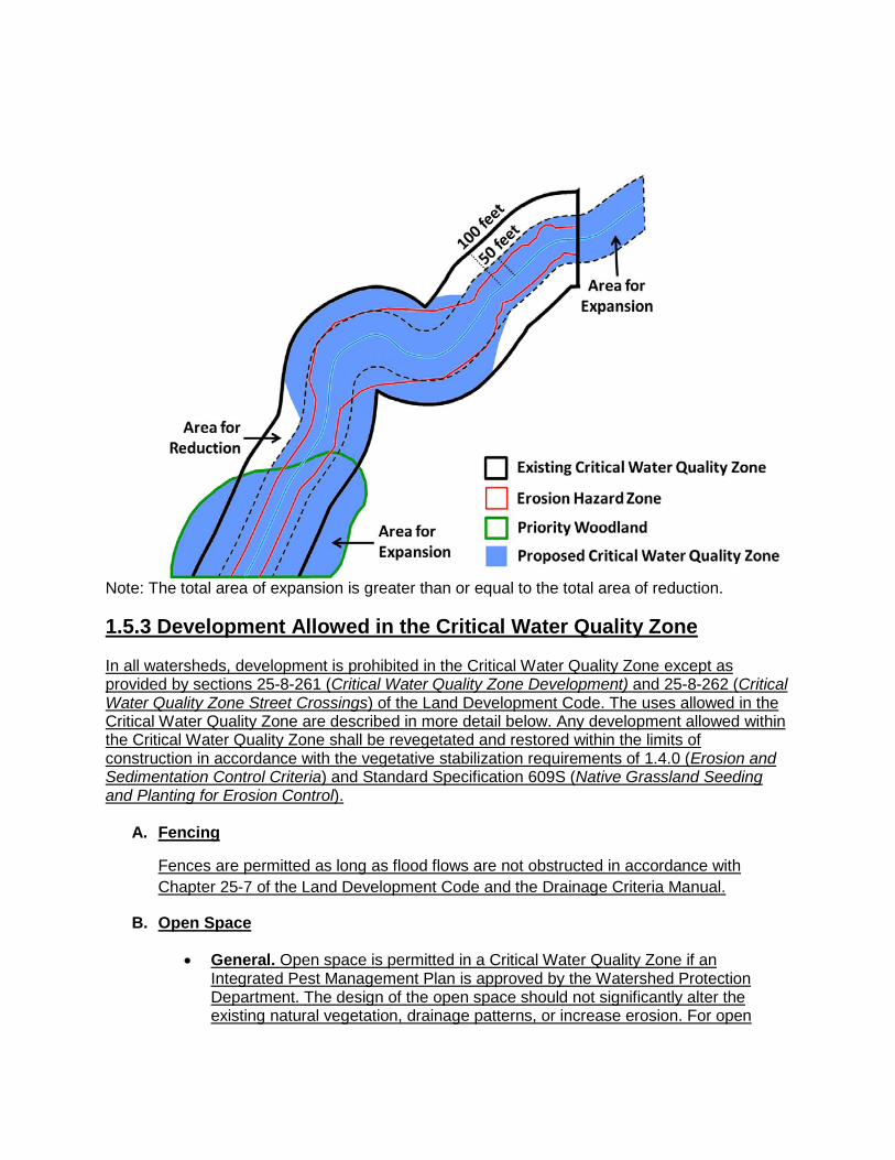
A Water Quality Transition Zone is not applied in urban or suburban watersheds. A Water Quality Transition Zone is also not applied on the shorelines of Lake Austin, Lake Travis, or Lady Bird Lake. 1.5.1 D. Buffer Averaging Within Suburban watersheds, the Critical Water Quality Zone boundaries may be reduced to not less than 50 feet from the centerline of a minor waterway, 100 feet from the centerline of an intermediate waterway, and 150 feet from the centerline of a major waterway if the overall surface area of the buffer is the same or greater. The overall surface area of the buffer can be retained or increased by either:
• providing a wider Critical Water Quality Zone somewhere else on the site; or • extending the Critical Water Quality Zone to unclassified waterways on the site (i.e. less
than 64 acres of drainage). The area proposed for reduction in width should not contain critical environmental feature (CEF) setbacks or priority or other significant woodlands and prairies as identified by the Environmental Resource Inventory. The area proposed for buffer expansion must always be contiguous to the overall Critical Water Quality Zone and should maintain a reasonable connection with the functions of the riparian zone and floodplain. Since the area proposed for buffer expansion will be classified as Critical Water Quality Zone, uses allowed within this area would be regulated by Sections 25-8-261 (Critical Water Quality Zone Development) and 25-8-262 (Critical Water Quality Zone Street Crossings) of the Land Development Code. If proposing to use buffer averaging on a minor waterway, the applicant will need to perform an Erosion Hazard Zone analysis in accordance with Chapter 25-7 of the Land Development Code and the Drainage Criteria Manual. The area proposed for reduction in width should not be located within the Erosion Hazard Zone.
The development application must show the original Critical Water Quality Zone, the areas proposed for reduction, and the areas proposed for expansion. The application should also delineate, where applicable:
• the minimum setbacks (50 feet, 100 feet, 150 feet) required for buffer averaging; • critical environmental feature setbacks; • priority or other significant woodlands and prairies identified by the Environmental
Resource Inventory; and • the Erosion Hazard Zone delineated for minor waterways
In addition, a table should be provided to summarize the reductions and expansions of the Critical Water Quality Zone area as follows:
Existing Critical Water Quality Zone _________________ acres Areas Proposed for Reduction – _________________ acres Areas Proposed for Expansion + _________________ acres
Proposed Critical Water Quality Zone _________________ acres
The area calculated in the table for the Proposed Critical Water Quality Zone must be greater than or equal to the area of the Existing Critical Water Quality Zone. Example of Buffer Averaging on a Minor Waterway
Note: The total area of expansion is greater than or equal to the total area of reduction.
1.5.3 Development Allowed in the Critical Water Quality Zone
In all watersheds, development is prohibited in the Critical Water Quality Zone except as provided by sections 25-8-261 (Critical Water Quality Zone Development) and 25-8-262 (Critical Water Quality Zone Street Crossings) of the Land Development Code. The uses allowed in the Critical Water Quality Zone are described in more detail below. Any development allowed within the Critical Water Quality Zone shall be revegetated and restored within the limits of construction in accordance with the vegetative stabilization requirements of 1.4.0 (Erosion and Sedimentation Control Criteria) and Standard Specification 609S (Native Grassland Seeding and Planting for Erosion Control).
A. Fencing
Fences are permitted as long as flood flows are not obstructed in accordance with Chapter 25-7 of the Land Development Code and the Drainage Criteria Manual.
B. Open Space
• General. Open space is permitted in a Critical Water Quality Zone if an Integrated Pest Management Plan is approved by the Watershed Protection Department. The design of the open space should not significantly alter the existing natural vegetation, drainage patterns, or increase erosion. For open
space uses other than multi-use trails, significant alteration of existing natural vegetation and/or drainage patterns includes:
- clearing of woody vegetation for an area greater than fifteen feet wide or a smaller area if the proposed clearing is not commensurate with the use and anticipated maintenance needs;
- removal of native, non-invasive trees greater than eight inches in diameter;
- grading or earthwork that would require between two and four feet of cut and fill;
- the installation of impervious cover with a connected footprint of greater than 100 square feet; or
- the installation of impervious cover such that the cumulative total within the Critical Water Quality Zone for the site is greater than 500 square feet or 5 percent of the total gross area of the Critical Water Quality Zone, whichever is smaller.
A project proposing to exceed these guidelines due to unique site conditions may be evaluated and approved by the Planning and Development Review Department.
In addition, the project shall ensure that runoff is dispersed back to overland sheet flow and maximum projected flows and velocities are below erosive values for the particular soil conditions.
Open space includes the following uses:
• Public or Private Park. Park facilities include uses like picnic facilities, benches, community gardens, and other recreational amenities and appurtenances. However, parking lots are not an allowed use within the Critical Water Quality Zone. Requirements and guidance for sustainable urban agriculture and community gardens are discussed further below.
• Multi-Use Trail. A multi-use trail means a facility designed for the use of pedestrians, bicycles, and/or other non-motorized users, including associated bridges. A multi-use trail can be either hard-surfaced (e.g. concrete) or have a more natural surface. Requirements and guidance for trails are discussed further below.
• Golf Cart Path. The requirements for a golf cart path within the Critical Water Quality Zone shall be identical to those for a hard-surfaced trail, with the exception of allowing a motorized use.
• Portion of a Golf Course Left in a Natural State. Portions of the golf courses, including disc golf, that are actively managed (i.e., mowed, irrigated, compacted, and/or fertilized) cannot be located within the Critical Water Quality Zone. An “Out of Bounds” area would be an example of a portion left in a natural state.
• Area Intended for Outdoor Activities. An area or facility intended for outdoor recreational activities such as a multi-purpose playfield. Outdoor facilities may include athletic fields, stables, or corrals for animals; however, these uses are prohibited within the Drinking Water Protection Zone. Requirements and guidance for athletic fields are discussed further below.
In a water supply rural watershed, a water supply suburban watershed, or the Barton Springs Zone, open space is limited to sustainable urban agriculture, community gardens, multi-use trails, picnic facilities, and outdoor facilities, excluding stables, corrals for animals, and athletic fields. A master planned park that is approved by Council may include recreational development other than the uses described under open space.
• Trails
Requirements
In all watersheds, multi-use trails—including hard-surfaced trails—may cross a Critical Water Quality Zone of any waterway. A trail with an earthen surface or soft surface (e.g. mulch, decomposed granite) is allowed anywhere within the Critical Water Quality Zone, provided that the trail follows the basic guidance for placement and design provided below. A trail with an earthen or soft surface should not exceed 6 feet in width if located closer to the waterway than the requirements for hard-surfaced trails. Otherwise, the maximum width shall be 12 feet, unless a wider trail is designated in the Urban Trails Master Plan. A hard surface (e.g. concrete) of less than or equal to 100 square feet may be installed for a limited length of what is otherwise an earthen surface or soft surface trail to avoid drainage or erosion problems.
A hard-surfaced trail includes a trail constructed using concrete or asphalt. A hard-surfaced trail is allowed within the Critical Water Quality Zone if:
1. Located outside of the erosion hazard zone, unless protective works are provided in accordance with the Drainage Criteria Manual
2. A maximum of 12 feet wide, unless a wider trail is designated in the Urban Trails Master Plan
3. In an urban watershed, located not less than 25 feet from the centerline of a waterway
4. In a watershed other than urban, located not less than 50 feet from the centerline of a minor waterway, 100 feet from the centerline of an intermediate waterway, or 150 feet from the centerline of a major waterway;
In addition to these conditions, hard-surfaced trails should also follow the basic guidance for placement and design provided below.
Placement and Design
Avoid Sensitive Environmental Areas. A natural surface trail for hiking may be located within 50 feet of a critical environmental feature (CEF). Otherwise, multi-
use trails are prohibited within CEF setbacks. The trail should avoid other environmentally sensitive areas where possible or take sufficient steps to minimize impacts on these systems. Other environmentally sensitive areas include priority or other significant woodlands and prairies as identified by the Environmental Resource Inventory. The trail should not be located along the sideslope of an embankment or in other areas with high erosion potential. If the applicant is proposing a hard-surfaced trail within 100 feet of the centerline of the waterway, they will need to perform an erosion hazard zone analysis.
Utilize Areas that are Already Disturbed. Where feasible, locate trails in areas that have already been influenced by human activity, such as abandoned roads, utility easements, and existing paths. However, the trail must be located such that it does not threaten existing infrastructure, including, but not limited to, structural stormwater controls, engineered channels, storm drains, culverts, and dams.
Promote Sustainable Trail Design. One of the most critical components of trail design is how the trail affects water flow and how the trail is affected by water. Trails that limit natural drainage patterns will often result in erosion, surface ponding, and high frequency of flows on the trail which limits access and can significantly degrade the trail over time. The trail should promote the sheet flow of stormwater runoff and maintain natural drainage paths whenever possible through design considerations like trail location, grade, and cross slope. Trails using decomposed granite should limit the running slope and cross slope to reduce sloughing and gullying. A running slope of less than 3 percent and a cross slope of less than 2 percent are recommended.
For further guidance on sustainable trail design, see the following references:
U.S. Forest Service, Trail Construction and Maintenance Notebook http://www.fhwa.dot.gov/environment/recreational_trails/publications/fs_publications/07232806/
Federal Highways Administration, Recreational Trails Program, Guidance http://www.fhwa.dot.gov/environment/recreational_trails/guidance/manuals.cfm
American Trails, Resources and Library http://www.americantrails.org/resources/trailbuilding/index.html
Administrative Variance
An administrative variance is available under 25-8-42 to allow a hard-surfaced trail to be placed closer to the waterway than designated in 25-8-261(B)(3). To qualify for this variance, the applicant will need to demonstrate that placement of the trail in the outer half of the Critical Water Quality Zone is infeasible due to unique site conditions including but not limited to.
• Location of existing development or infrastructure within the outer half of the Critical Water Quality Zone
• Not owning land within the outer half of the Critical Water Quality Zone
• Location of environmentally sensitive features (e.g., critical environmental features, steep slopes) within the outer half of the Critical Water Quality Zone
• A hard surface (e.g. concrete) of greater than 100 square feet is necessary for a limited length of what is otherwise an earthen or soft surface trail within the inner half of the Critical Water Quality Zone to avoid drainage or erosion problems.
The proposed trail alignment under the variance should be a minimal departure from the requirements. The trail should only cross into the inner half of the Critical Water Quality Zone where necessary to avoid existing features and to minimize the overall disturbance.
• Sustainable Urban Agriculture
Sustainable urban agriculture promotes environmentally-sensitive management practices, such as water conservation and integrated pest management methods. Sustainable urban agriculture can include either a community garden, market garden, or urban farm, as defined by Section 25-2-7 (Agricultural Uses Described) of the Land Development Code. A community garden use involves the growing or harvesting of food crops or ornamental crops on an agricultural basis by a group of individuals for personal or group use, consumption, or donation. A market garden is less than one acre in size and cultivated primarily for the sustainable production of agricultural products to be sold for profit. An urban farm is at least one acre in size and cultivated primarily for the sustainable production of agricultural products to be sold for profit.
Sustainable urban agriculture is allowed in the Critical Water Quality Zone if:
1. In an urban watershed, the area is located not less than 25 feet from the centerline of a waterway.
2. In a watershed other than urban, the area is located not less than 50 feet from the centerline of a minor waterway, 100 feet from the centerline of an intermediate waterway, or 150 feet from the centerline of a major waterway.
3. The area is limited to garden plots and paths, with no storage facilities or other structures over 500 square feet. The square footage of all storage facilities and other structures shall be totaled for the area and shall not exceed 500 square feet on a cumulative basis. A single storage facility or structure (e.g., a toolshed) should not exceed 100 square feet.
The raising of fowl or livestock is prohibited. All compost and stored materials areas must be contained to prevent runoff and sedimentation. Manure is not allowed to be stored on site. Fuel storage is prohibited on site. The use of synthetic inputs (i.e. synthetic fertilizers, herbicides, and pesticides) is prohibited. An Integrated Pest Management Plan must be approved by the Watershed Protection Department. Water conservation practices must be followed, at minimum in accordance with Chapter 6-4 (Water Conservation) of the City Code.
• Athletic Fields
Athletic fields within the Critical Water Quality Zone shall be limited to vegetated sports fields, such as soccer, football, and baseball fields. Impervious sport courts, such as tennis or basketball courts are not allowed. Minor necessary appurtenances like bleachers are allowed as long as the connected impervious footprint does not exceed 100 square feet.
Athletic fields are allowed in the Critical Water Quality Zone if:
1. In an urban watershed, the area is located not less than 25 feet from the centerline of a waterway.
2. In a suburban watershed, the area is located not less than 50 feet from the centerline of a minor waterway, 100 feet from the centerline of an intermediate waterway, or 150 feet from the centerline of a major waterway.
3. The owner of the athletic field submits a maintenance plan to keep the athletic field well vegetated and minimize compaction. The plan must be approved by the Watershed Protection Department.
The maintenance plan shall include:
• An Integrated Pest Management (IPM) Plan.
• A minimum mowing height for turf.
• A provision for aerating the field and top dressing the field. This should be performed annually or more frequently on an as needed basis.
• A provision for amending the soil twice a year or more frequently on an as needed basis with compost or organic fertilizers to replenish deficient minerals and nutrients.
• A provision for long term soil rehabilitation if regular maintenance is insufficient to loosen compacted soils. Long term soil rehabilitation would include scarifying and amending the soil. After completion of the soil rehabilitation, the athletic field should be sodded with appropriate turf for athletic use.
C. Boat Docks, Piers, Wharfs, and Marinas
Boat docks, piers, wharfs, and marinas, as well as necessary access and appurtenances, are permitted along Lake Travis, Lake Austin, and Lake Travis. These uses are not permitted along the Colorado River downstream of Longhorn Dam. Approval by the Watershed Protection Department of chemicals used to treat the building materials that will be submerged in water is required before a permit may be issued or a site plan released.
D. Utility Crossings
Utility lines, including storm drains, may extend into or through the Critical Water Quality Zone if the applicant demonstrates the crossing is necessary and that a feasible
alternative to the crossing does not exist. This includes a partial crossing of the Critical Water Quality Zone that may be necessary to connect to existing infrastructure or discharge stormwater from a site. A crossing may also include a minor connection between existing infrastructure entirely within the Critical Water Quality Zone if the total length of the connection is less than the total width of the Critical Water Quality Zone.
In addition, the utility line must demonstrate compliance with the following:
• The line must follow the most direct path into or across the Critical Water Quality Zone to minimize disturbance unless boring or tunneling is the proposed method of installation for the entire crossing and all bore pits are located outside of the Critical Water Quality Zone;
• The depth of the line and associated access shafts may not be located within the surface or subsurface erosion hazard zone, as defined by Appendix F of the Drainage Criteria Manual, unless protective works are provided; and
• In the Barton Springs Zone, the crossing must be approved by the director of the Watershed Protection Department.
E. Parallel Utilities
In addition to necessary crossings, utility lines may be located parallel to and within the Critical Water Quality Zone in urban and suburban watersheds if:
1. In an urban watershed, the area is located not less than 50 feet from the centerline of a waterway.
2. In a suburban watershed, the area is located not less than 50 feet from the centerline of a minor waterway, 100 feet from the centerline of an intermediate waterway, or 150 feet from the centerline of a major waterway.
3. The utility line is located outside of the erosion hazard zone, unless protective works are provided.
4. In addition to restoring within the limits of construction in accordance with the vegetative stabilization requirements of 1.4.0 (Erosion and Sedimentation Control Criteria), the project restores an area within the Critical Water Quality Zone equal in size to the area of disturbance. In other words, for every square foot disturbed, the applicant shall restore an additional square foot within the Critical Water Quality Zone outside of the area of disturbance.
The alignment may not cross setbacks for critical environmental features (CEFs) and should avoid other environmentally sensitive areas or take sufficient steps to minimize impacts on these systems. Other environmentally sensitive areas include priority or other significant woodlands and prairies as identified by the Environmental Resource Inventory. The proposed alignment should not disturb significant amounts of vegetation. The applicant will need to perform a Zone 2 functional assessment of the Critical Water Quality Zone to determine which restoration techniques (if any) should be applied. See Section 1.7.4 and Appendix X (Functional Assessment of Floodplain Health) of this manual for further guidance. If the condition of the Critical Water Quality Zone is determined to be poor or fair, the applicant shall prepare and submit a Riparian
Restoration Plan to be reviewed and approved by the Watershed Protection Department. See Section 1.7.5 (Restoration) of this manual for further guidance on the components of the Riparian Restoration Plan. If a Zone 2 functional assessment shows the Critical Water Quality Zone is already in good condition or better or the site does not have enough area within the adjacent Critical Water Quality Zone to meet the restoration requirements, then the applicant shall pay into the Riparian Zone Mitigation Fund a non-refundable amount established by ordinance (see Appendix Q-7 of this manual).
F. Detention Basins and Wet Ponds
In-channel detention basins and wet ponds can be located within the Critical Water Quality Zone if the requirements of Section 25-8-364 (Floodplain Modification), 25-7 (Drainage), and other provisions 25-8 Subchapter A are met. For guidance on how to demonstrate compliance with these requirements, see section 1.7.3.C (Development Allowed within the Critical Water Quality Zone) of the Floodplain Modification Criteria in this manual.
G. Floodplain Modification
Floodplain modifications are prohibited in the Critical Water Quality Zone unless:
1. the floodplain modifications proposed are necessary to protect the public health and safety;
2. the floodplain modifications proposed would provide a significant, demonstrable
environmental benefit, as determined by a functional assessment of floodplain health; or
3. the floodplain modifications proposed are necessary for development allowed in
the Critical Water Quality Zone under section 25-8-261 (Critical Water Quality Zone Development) or 25-8-262 (Critical Water Quality Zone Street Crossings).
For additional guidance on floodplain modification within the Critical Water Quality Zone, see section 1.7.0 (Floodplain Modification Criteria) of this manual.
H. Green Water Quality Controls
In urban and suburban watersheds, vegetative filter strips, rain gardens, biofiltration ponds, and areas used for irrigation or infiltration of stormwater are allowed within the Critical Water Quality Zone if:
1. In an urban watershed, located not less than 50 feet from the centerline of a waterway;
2. In a suburban watershed, located not less than 50 feet from the centerline of a minor waterway, 100 feet from the centerline of an intermediate waterway, or 150 feet from the centerline of a major waterway;
3. Located outside the 100-year floodplain; and
4. Located outside the erosion hazard zone, unless protective works are provided as prescribed in the Drainage Criteria Manual.
Green water quality ponds within the Critical Water Quality Zone shall be constructed using earthen side slopes rather than concrete retaining walls. Mortared limestone block may be utilized to construct walls up to 12 inches in height. In addition, the project engineer should consider the following guidance when siting and designing green water quality ponds within the Critical Water Quality Zone:
• Locate the ponds as far from the waterway as feasible to minimize encroachment into the buffer
• Place the outfall as far from the waterway as feasible to maximize the distance of overland flow
• Evaluate opportunities for using smaller-scale distributed controls to minimize the depth of excavation within the buffer
I. Residential Lots
A new residential lot that is 5,750 square feet or less in size may not include any portion of the Critical Water Quality Zone.
J. Street Crossings
In all watersheds, multi-use trails may cross a Critical Water Quality Zone of any waterway. In an urban watershed, an arterial, collector, or residential street may cross a Critical Water Quality Zone of any waterway. In a watershed other than urban, the following restrictions apply to street crossings:
• a major waterway may be crossed by an arterial street identified in the Transportation Plan
• an intermediate waterway may be crossed by an arterial or collector street, except:
o a collector street crossing must be at least 2,500 feet from a collector or arterial street crossing on the same waterway; or
o in a water supply suburban or water supply rural watershed, or the Barton Springs Zone, a collector street crossing must be at least one mile from a collector or arterial street crossing on the same waterway
• a minor waterway may be crossed by an arterial and collector streets, except:
o a collector street crossing must be at least 1,000 feet from a collector or arterial street crossing on the same waterway; or
o in a water supply suburban or water supply rural watershed, or the Barton Springs Zone, a collector street crossing must be at least 2,000 feet from a collector or arterial street crossing on the same waterway
• a minor waterway may be crossed by a residential or commercial street if necessary to provide access to property that cannot otherwise be safely accessed.
Notwithstanding the restrictions above, a street or driveway may cross the Critical Water Quality Zone if the street or driveway is located in a designated center or corridor on the Imagine Austin growth concept map and if the proposed crossing is:
• located outside of the Barton Springs Zone;
• necessary to facilitate development or redevelopment of a designated center or corridor as recommended in the Imagine Austin Comprehensive Plan; and
• maintains the quality and quantity of recharge if located in a center or corridor designated as a sensitive environmental area in the Edwards Aquifer recharge zone or contributing zone, as determined by the director of the Watershed Protection Department.
Designated Imagine Austin centers or corridors must have an adopted boundary to qualify for this provision.
1.5.4 Development Allowed in the Water Quality Transition Zone The Water Quality Transition Zone only applies to water supply rural watersheds, water supply suburban watersheds, and in the Barton Springs Zone, excluding the shorelines of Lake Austin, Lake Travis, and Lady Bird Lake. Over the South Edwards Recharge Zone, development is prohibited in a Water Quality Transition Zone, except for:
1. development described in Article 7, Division 1 (Critical Water Quality Zone Restrictions) of the Land Development Code and further detailed in Section 1.5.3 above; and
2. minor drainage facilities or water quality controls that comply with Section 25-8-364 (Floodplain Modification) and the floodplain modification guidelines of this manual.
Note: Minor drainage facilities include drainage appurtenances necessary for conveyance and outfall. Minor water quality facilities are relatively low-impact, green controls and include vegetative filter strips, rain gardens, and areas used for irrigation or infiltration of stormwater.
Outside of the South Edwards recharge zone, the following development is allowed in a Water Quality Transition Zone:
Water Supply Suburban
1. impervious cover equal to 18 percent of the land area within the Water Quality Transition Zone, excluding land in the 100 year floodplain; and
2. water quality controls.
Water Supply Rural
1. development described in Article 7, Division 1 (Critical Water Quality Zone Restrictions) of the Land Development Code and further detailed in Section 1.5.3 above;
2. streets;
3. minor drainage facilities or water quality controls that comply with Section 25-8-364 (Floodplain Modification) and the floodplain modification guidelines of this manual; and
4. duplex or single-family residential development with a minimum lot size of two acres and a density of not more than one unit for each three acres, excluding acreage in the 100 year floodplain.
Note: A lot that lies within a Critical Water Quality Zone must also include at least two acres in a water quality transition zone or uplands zone. Minor drainage facilities include drainage appurtenances necessary for conveyance and outfall. Minor water quality facilities are relatively low-impact, green controls such as vegetative filter strips, rain gardens, and areas used for irrigation or infiltration of stormwater.
Barton Springs Zone
1. development described in Article 7, Division 1 (Critical Water Quality Zone Restrictions) of the Land Development Code and further detailed in Section 1.5.3 above;
2. streets;
3. minor drainage facilities or water quality controls that comply with Section 25-8-364 (Floodplain Modification) and the floodplain modification guidelines of this manual; and
4. duplex or single-family residential development with a minimum lot size of two acres and a density of not more than one unit for each three acres, excluding acreage in the 100 year floodplain.
Note: Minor drainage facilities include drainage appurtenances necessary for conveyance and outfall. Minor water quality facilities are relatively low-impact, green controls and include vegetative filter strips, rain gardens, and areas used for irrigation or infiltration of stormwater.