Page 1
Poolbeg Planning Scheme EIS February 2009
Cunnane Stratton Reynolds Effect on the Environment: Material Assets - Archaeological Heritage
1
18.0 EFFECT ON THE ENVIRONMENT: Material Assets -
Archaeological Heritage.
18.1 Introduction.
18.1.1 This chapter has been prepared by Cultural Resource Development Services Ltd. and
describes the archaeological heritage of the Draft Planning Scheme Area and will
concentrate upon the potential impact of the Draft Planning Scheme upon said
archaeological heritage.
18.1.2 Legislative Context.
18.1.2.1 The principal legislative instrument for the protection of archaeological heritage in
Ireland is the National Monuments Acts, 1930-2004. Other relevant legislation and
guidance include:
• The European Convention on the Protection of the Archaeological Heritage
(Valetta Convention), 1992.
• National Heritage Plan, 2002.
• The Heritage Act, 1995.
• The National Cultural Institutions Act, 1997.
• Framework and Principles for the Protection of the Archaeological Heritage,
1999, Department of the Arts, Heritage, Gaeltacht and the Islands.
• The Planning and Development Acts, 2000 - 2006.
• Advice notes on Current Practice (in the preparation of Environmental Impact
Statements), 2003, Environmental Protection Agency.
• Guidelines on the information to the contained in Environmental Impact
Statements, 2002, Environmental Protection Agency.
18.1.3 Dublin Docklands Master Plan 2008
18.1.3.1 Within the Dublin Docklands Master Plan 2008 environmental protection objectives
(Dublin Docklands Area Master Plan 2008, Section 6) seek to protect and enhance
archaeological heritage by the following policies:
Page 2
Poolbeg Planning Scheme EIS February 2009
Cunnane Stratton Reynolds Effect on the Environment: Material Assets - Archaeological Heritage
2
• Ensure the sites identified as being of possible interest in the Zone of
Archaeological interest (and in the Inventory of Industrial Archaeology) are fully
investigated and recorded (UD 63).
• Archaeological material to be protected in-situ by ensuring that only minimal
impact on archaeological layers is permitted. In particular, any proposed
development at Liffey Quay walls and canal quay walls to minimise interference
with the quay wall and keep the historic fabric in-situ (UD 64).
• Site-specific mitigation strategies, for development in any planning scheme or
amended planning scheme areas, to be formulated by the Authority in conjunction
with the Dublin City archaeologist, the National Museum of Ireland, and the
National Monuments Section and Underwater Unit of the DoEHLG (UD 65).
• Any proposed developments that may have implications for underwater
archaeology to be the subject of underwater archaeological assessment in advance
of works. In particular, in areas where disturbance of the River Liffey bed is
necessary as part of construction of any Planning Scheme and any Amended
Planning Scheme, an inter-tidal and underwater assessment to be carried out by a
suitably qualified underwater archaeologist licensed by the DoEHLG (UD 66).
• Archaeological monitoring during geological investigations and the construction
phase of any Planning Scheme and any Amended Planning Scheme to be
undertaken by an archaeologist licensed by the DoEHLG (UD 67).
• Protect the archaeological heritage of the Dockland Area and ensure that proposed
development within the designated city centre Zone of Archaeological Potential is
not detrimental to the character of the archaeological site or its setting (UD 68).
• Explore the possibility of exposing and restoring that part of the Great South Wall
currently underground, possibly as a waterfront edge (UD 55).
18.2 Assessment Methodology.
18.2.1 For the purpose of setting the proposed development within its wider archaeological
landscape and to assess the archaeological potential of the site, a desk-based
assessment utilising the Record of Monuments and Places, the National Museum of
Ireland Topographical Files, the Dublin City Development Plan 2005 – 2011,
Page 3
Poolbeg Planning Scheme EIS February 2009
Cunnane Stratton Reynolds Effect on the Environment: Material Assets - Archaeological Heritage
3
documentary and cartographic sources was undertaken. This was supplemented by a
site survey of the Draft Planning Scheme Area. The location of Recorded
Archaeological Monuments and Places is shown in Figure 18.2.1.1.
Page 4
Poolbeg Planning Scheme EIS February 2009
Cunnane Stratton Reynolds Effect on the Environment: Material Assets - Archaeological Heritage
4
Figure 18.2.1.1 Recorded Monuments and Places within the Draft Planning Scheme Area.
Page 5
Poolbeg Planning Scheme EIS February 2009
Cunnane Stratton Reynolds Effect on the Environment: Material Assets - Archaeological Heritage
5
18.2.2 Recorded Archaeological Monuments and Places and Draft Maritime Sites and
Monuments Record.
18.2.2.1 The Record of Monuments and Places was consulted for the relevant parts of the city.
This is a list of archaeological sites known to the National Monuments Service (see
also www.archaeology.ie). The relevant files for these sites contain details of
documentary sources and aerial photographs, early maps, OS memoirs, OPW
Archaeological Survey notes and other relevant publications. Further information on
individual monuments was obtained in the Urban Archaeological Survey for Dublin
City. The list of National Monuments in State Ownership or State Guardianship, the
Register of Historic Monuments, the Sites and Monuments Record and monuments
covered by Preservations Orders were also assessed. All sites within the Draft
Planning Scheme Area were identified and are listed in Appendix 18.1. The Draft
Maritime SMR was consulted for the relevant part of the city. The Draft Maritime
Sites and Monuments Record contains an inventory of recorded shipwrecks in Ireland,
produced by the Underwater Unit in the Department of Environment, Heritage and
Local Government. Recorded shipwrecks in the vicinity of the Draft Planning Scheme
Area are listed in Appendix 18.2.
18.2.3 Recorded Archaeological Finds.
18.2.3.1 The topographical files in the National Museum of Ireland were consulted to determine
if any archaeological artefacts had been recorded from the area. This is the national
archive of all known finds recorded by the National Museum. It relates primarily to
artefacts but also includes references to monuments and has a unique archive of records
of previous excavations. Other published catalogues of prehistoric material were also
studied: Raftery (1983 - Iron Age antiquities), Eogan (1965; 1993; 1994 - bronze
swords, Bronze Age hoards and goldwork), Harbison (1968; 1969a; 1969b - bronze
axes, halberds and daggers) and the Irish Stone Axe Project Database (School of
Archaeology, U.C.D.). All streets within the Draft Planning Scheme Area were
assessed. A list of recorded finds from the area is given in Appendix 18.3.
Page 6
Poolbeg Planning Scheme EIS February 2009
Cunnane Stratton Reynolds Effect on the Environment: Material Assets - Archaeological Heritage
6
18.2.4 Cartographic Sources.
18.2.4.1 Reference to cartographic sources provides information on the development of the area
from the late 17th century. Pre-Ordnance Survey cartographic sources included Thomas
Philips’ ‘A survey of the city of Dublin’, 1685, Charles Brooking’s ‘A map of the city
and suburbs of Dublin’, 1728, John Rocque’s ‘Plan of the city of Dublin’, 1756 and
John Taylor’s ‘Map of the environs of Dublin’ 1820. Early maps from the Dublin Port
Board Collection were also assessed. Additional maps were consulted in the Trinity
College Map Library and consisted of the Ordnance Survey 6" maps, first and later
editions.
18.2.5 Previous Excavations.
18.2.5.1 The Excavations bulletin website (www.excavations.ie) was consulted to identify
previous excavations that may have been carried out within the Draft Planning Scheme
Area. This database contains summary accounts of excavations carried out in Ireland
from 1970 to 2004. Summaries of the results of these investigations are outlined in
Appendix 18.4.
18.2.6 Historical Research.
18.2.6.1 Historical sources consulted included The Liffey in Dublin (De Courcy 1996) and the
Dublin Docklands Architectural Survey (University College Dublin School of
Architecture, 1996), the Royal Historical Society Bibliography (www.rhs.ac.uk/bibl),
the Planning Architecture Design Database Ireland (www.paddi.net) and the British
and Irish Archaeological Bibliography (www.biab.co.uk).
18.2.7 Site Assessment.
18.2.7.1 An assessment of the site of the planning scheme area was undertaken on various dates
in late 2007 and early 2008. The purpose of the site assessments was to examine known
archaeological monuments and places on or in the vicinity of the development and to
identify new sites and areas of archaeological heritage potential.
Page 7
Poolbeg Planning Scheme EIS February 2009
Cunnane Stratton Reynolds Effect on the Environment: Material Assets - Archaeological Heritage
7
18.3 The Receiving Environment.
18.3.1 The banks of the Liffey estuary may have been used on a temporary basis for hunting
and fishing in the prehistoric period. Archaeological material associated with this form
of exploitation includes fish traps, other fishing structures such as wooden posts and
dug out boats. During recent archaeological monitoring undertaken on the north bank
of the river at North Wall Quay deposits of estuarine silts and gravel shorelines have
been found representing a bank of the river channel or an island within the Liffey
estuary (McQuade and O'Donnell 2006, 569; O’Sullivan and Breen 2007). The
deposits, which contained the remains of fishtraps, were dated to around 7000 BP or
the Late Mesolithic period. The deposits were found at a depth of 6.3m below mean sea
level indicating significant changes in the ground level conditions. The site was
located under land reclaimed from the Liffey, but would originally have been on the
foreshore of the river.
18.3.2 The earliest references to the Poolbeg area date to the later part of the medieval era and
it was known by that name (which means ‘Little Pool’) from at least 1488. Poolbeg is
known to have been part of the lands of Thorncastle in 1306, but is not named
specifically in the documents at this time. The 1673 map of Dublin by De Gomme
depicts ‘Poole Beg’ as the channel between the North and South Bulls indicating that it
was defined as a smaller area than it was in the 19th century when it stretched from the
lighthouse all the way to the Pigeon House precinct (De Courcy 1996, 310- 311;
D’Alton 1838, 853).
18.3.3 The Pigeon House precinct, which makes up a substantial part of the Draft Planning
Scheme Area, was known at the end of the 17th and beginning of the 18th century as the
Green Patch and was a small, isolated area used as an early staging place for ships
unloading in the estuary (De Courcy 1996, 298). At this time the River Liffey ran in an
irregular channel, shallow in places and with few quay walls. From early in the 18th
century it was decided to construct a breakwater running eastwards from Ringsend
which would contain the river and allow the channel to be deepened. The earliest
breakwater consisted of a double row of timber piles, known as ‘the Piles’, driven into
the sandbanks. Stones, gravel and shingle were then laid along the line of the timbers.
Page 8
Poolbeg Planning Scheme EIS February 2009
Cunnane Stratton Reynolds Effect on the Environment: Material Assets - Archaeological Heritage
8
Construction began at the mid-point of the piles and progressed eastwards and
westwards from there. By 1731 the piles ran from the future site of the Pigeon Harbour
as far east as the future site of the Pigeon House Lighthouse a distance of over 3000m
(De Courcy 1996, 375-6). They are shown on Rocque’s Actual Survey of the City of
Dublin, 1760. What is currently known as the Pigeon House precinct is shown as Zone
4 in Figure 2.2.3.1.
18.3.4 Up until the construction of the piles and later the Great South Wall, the sandbars at the
mouth of the river were treacherous to shipping. While the majority of recorded
shipwrecks are within the channel of the river early 19th century cartographic sources
also show shipwrecks on the South Bull. The South Bull was an area of shifting sand
which developed to the south of the wall and could be covered at high tides.
18.3.5 By the mid-18th century the Ballast office suggested constructing a stone river wall to
bridge the gap between Ringsend Point and the west end of the Piles. The construction
of a double wall, ‘the Ballast Office Wall’ was completed by 1759. The construction
of a stone river wall along the line of ‘the Piles' began soon after and was completed
between 1792 and 1795 as far as Poolbeg Lighthouse.
18.3.6 Part of this project saw the construction of the Pigeon House Harbour and the
Blockhouse. This later building was used as a storehouse and became known as the
Pigeon House, after a John Pigeon became its resident supervisor and caretaker in
1761. His name was also lent to the part of the Salmon Pool ‘the Pigeon House Hole’
which was used as a mooring place for cross-channel boats. Many of the people
passing through here would stop for refreshments at the resting place established by
Pigeon and his family. Development continued in the 18th century, as further wharfs,
accommodation, a Revenue Barracks (DU018-05305), a Storehouse and a wall
protecting the south shore of the precinct from waves were added. In 1791 a new
harbour was planned which used the South Wall as its southern and eastern quays and a
new wall in the channel of the Liffey as its northern and western sides (De Courcy
1996, 298-99; Pearson 2000, 451). This was known as the Pigeon House Harbour or
Dock and came into service in 1793 (see Figure 18.3.6.1). In that same year the ornate
Page 9
Poolbeg Planning Scheme EIS February 2009
Cunnane Stratton Reynolds Effect on the Environment: Material Assets - Archaeological Heritage
9
and imposing Pigeon House Hotel was constructed to accommodate the increasing
cross-channel passenger traffic (De Courcy 1996, 298- 299; Pearson 2000, 451).
Page 10
Poolbeg Planning Scheme EIS February 2009
Cunnane Stratton Reynolds Effect on the Environment: Material Assets - Archaeological Heritage
10
Figure 18.3.6.1: The Pigeon House Precinct in 1912.
18.3.7 As a result of the 1798 uprising, the Pigeon House precinct, which was deemed a
worthy strong-point, became occupied by the military. This phase in the area’s history
witnessed the increased development of the site as buildings necessary for military
occupation such as soldier’s quarters, stores, magazines, a hospital, a canteen, a
handball alley, a prison and water tanks, were gradually added. Defensive measures
such as gateways at each end of the South Wall protected by trenches and drawbridges,
an armoury and guardhouse commanding the road from Ringsend and guns trained on
the South Bull sands and the mouth of the River were also instituted. This site was
henceforth known as the Pigeon House Fort (DU019-027) (De Courcy 1996, 299- 300).
In the late 19th century military occupation of the area was no longer deemed necessary
and it was sold to the Dublin Corporation.
Page 11
Poolbeg Planning Scheme EIS February 2009
Cunnane Stratton Reynolds Effect on the Environment: Material Assets - Archaeological Heritage
11
18.4 Relevant Characteristics of Draft Planning Scheme.
18.4.1 Development is proposed in close proximity to the recorded archaeological monuments
within the Draft Planning Scheme Area namely the Pigeon House Fort (DU019-027)
and the Great South Wall (DU018-066 and DU019-029).
18.4.2 The development of a transport corridor is proposed at the western end of the Great
South Wall (DU018-066).
18.4.3 The remains of the Pigeon House Fort (DU019-027) will be integrated into a mixed-use
cluster with residential, commercial and retail development. It is proposed that the
cluster could have a small museum explaining the history of the site and the fort.
18.4.4 Development at other locations within the Draft Planning Scheme Area will involve
subsurface interventions including the construction of building foundations,
underground parking and the insertion of services.
18.5 Likely Impact of the Draft Planning Scheme.
18.5.1 Developments may impact on the recorded archaeological monuments within the Draft
Planning Scheme Area namely the Pigeon House Fort (DU019-027) and the Great
South Wall (DU018-066 and DU019-029). In addition, there is the potential that the
Draft Planning Scheme will impact on previously unrecorded sub-surface
archaeological remains.
18.5.2 Construction Phase
18.5.2.1 The principal impact on archaeological heritage is through ground disturbance
associated with construction of the proposed scheme. This disturbance can involve site
clearance, sub-surface site investigation, ground preparation and excavation.
18.5.2.2 The construction of the proposed transport corridor may impact on the western end of
the Great South Wall (DU019-066) and associated subsurface archaeological remains.
18.5.2.3 Developments at other locations within the Draft Planning Scheme Area will involve
subsurface interventions including the construction of building foundations,
Page 12
Poolbeg Planning Scheme EIS February 2009
Cunnane Stratton Reynolds Effect on the Environment: Material Assets - Archaeological Heritage
12
underground parking and the insertion of services which may impact on unrecorded
subsurface archaeological material.
The integration of the remains of the Pigeon House Fort (DU019-027) into a mixed-use
development will have a positive impact on the standing remains.
18.5.3 Operational Phase
18.5.3.1 The operational phase of the scheme is unlikely to have any significant impacts on archaeological heritage.
‘Do-nothing’ Scenario.
18.5.3.2 Should the implementation of the planning scheme not occur then redevelopment may
occur across the peninsula in an uncoordinated manner. While the upstanding
archaeological sites would be largely unaffected in a do-nothing scenario they may be
allowed to further deteriorate without intervention.
18.6 Mitigation.
18.6.1 Any development in or in the vicinity of the recorded monuments will require the
developer to obtain the approval of the National Monuments Service of the Department
of Environment, Heritage & Local Government. In addition, there is the potential for
the survival of unrecorded sub-surface archaeological remains. Following finalisation
of detailed site design, site specific mitigation strategies in the form of archaeological
management plans will be formulated in conjunction with the Dublin City
Archaeologist, National Museum of Ireland and the National Monuments Section
and/or Underwater Unit of the Department of the Environment, Heritage and Local
Government. Mitigation will have due regard to the heritage policies and objectives
included in Chapter 10 of the Dublin City Development Plan 2005 – 2011 and in the
Docklands Master Plan 2008 (see above) and may include:
18.6.2 Pre-Development Archaeological Testing and Archaeological Excavation.
18.6.2.1 Pre-development archaeological testing is required by appropriate experts appointed by
developers where there is an indication that archaeological remains are likely to occur
as evidence from cartographic, historical or photographic sources may point to areas of
Page 13
Poolbeg Planning Scheme EIS February 2009
Cunnane Stratton Reynolds Effect on the Environment: Material Assets - Archaeological Heritage
13
archaeological significance. Targeted testing allows an assessment to be made on the
extent of any surviving archaeology before any further mitigation is decided upon.
Should any archaeological material be uncovered, either preservation in situ or full
archaeological excavation may be required (see below).
18.6.2.2 Archaeological excavation is the preservation by record of archaeological remains. It
would normally be undertaken following the discovery of archaeological material that
cannot be preserved by being left in-situ. Archaeological excavation may be required
by developers pending the results of pre-development testing. Any archaeological sites
identified during the course of advance archaeological investigations, or uncovered
during the construction phase of the project should be excavated in full following
consultation with the National Monuments Section of the Department of Environment,
Heritage and Local Government.
18.6.3 Monitoring.
18.6.3.1 Archaeological monitoring will be undertaken by Section 25 applicants during
geological investigations and construction phase of the Planning Scheme and any
Amended Planning Scheme by an archaeologist licensed by the Department of the
Environment, Heritage and Local Government.
18.6.4 Luas.
18.6.4.1 The archaeological impact associated with the development of any Luas line and/or
DRT through the Draft Planning Scheme Area will be appropriately assessed by the
provider (or developer) in conjunction with the appropriate state regulatory body.
18.6.5 Operational Phase
18.6.5.1 The operational phase of the project is unlikely to have any significant impacts on
archaeological heritage and no further archaeological mitigation is required.
Page 14
Poolbeg Planning Scheme EIS February 2009
Cunnane Stratton Reynolds Effect on the Environment: Material Assets - Archaeological Heritage
14
18.7 References.
Bennett, D., 1991. Encyclopedia of Dublin. Gill and Macmillan, Dublin.
Bradley, J. King, H.A. Unpublished. The Urban Archaeological Survey: Dublin City.
Unpublished report commissioned by the Office of Public Works.
Breen, C. and Forsythe, W. 2004. Boats and Shipwrecks of Ireland. Tempus
Publishing. Gloucestershire.
Clarke, H.B., 2002. Irish Historic Towns Atlas No. 11 (Dublin Part I, to 1610). Royal
Irish Academy, Dublin.
Clerkin, P., 2001. Dublin Street Names. Gill and Macmillan: Dublin.
De Courcy, J. W. 1996. The Liffey in Dublin. Gill and Macmillan: Dublin.
De Courcy, J.W. 2000. Bluffs, Bays and Pools in the medieval Liffey at Dublin in
Irish Geography Vol 33 (2), 117-133.
De Courcy, S. 1986. From Islandbridge to Ringsend: a note on the history of the Liffey
quays.
G. Cahill & L. Kealy (eds) Dublin City Quays: Projects by the School of Architecture
UCD, 11-14. Dublin: The School of Architecture, UCD.
Dublin City Council, 2005. Dublin City Development Plan 2005-2011. Dublin City
Council: Dublin.
Dublin Dockland Development Authority, 2001. Stack A Conservation Plan. DDDA:
Dublin.
Page 15
Poolbeg Planning Scheme EIS February 2009
Cunnane Stratton Reynolds Effect on the Environment: Material Assets - Archaeological Heritage
15
Eogan, G., 1965. A catalogue of Irish Bronze swords. Dublin.
Eogan, G., 1983. Hoards of the Irish Later Bronze Age. Dublin.
Eogan, G., 1994. The Accomplished Art, Gold and Gold working in Britain and
Ireland during the Bronze Age. Dublin.
F.H.A. and Whelan K., Dublin City and County: From Prehistory to Present.
Geography Publications, Dublin.
Guinness, D. 1979. Georgian Dublin. London: Batsford
Harbison, P., 1968. Catalogue of Irish Early Bronze Age associated finds containing
copper or bronze. Proceedings of the Royal Irish Academy 67C, 35-91.
Harbison, P., 1969a. The daggers and the halberds of the Early Bronze Age in Ireland.
Prähitorische Bronzefunde, Abteilung VI, Band 1. C.H. Beck, Munich.
Harbison, P., 1969b. The axes of the Early Bronze Age in Ireland. Prähitorische
Bronzefunde, Abteilung IX, Band 1. C.H. Beck, Munich.
Healy, E. et al. The Book of the Liffey: from source to sea, 130-131. Dublin:
Wolfhound Press.
Kissane, N. compiler. 1988. Historic Dublin Maps. The National Library of Ireland,
Dublin.
McQuade, M. and O’Donnell, L. 2006. Late Mesolithic fish traps from the Liffey
estuary, Dublin, Ireland in Antiquity 81 (2007) 569-584.
McQuade, M., 2005. North Wall Quay. Archaeology Ireland, Vol. 19 (2) Issue No. 72
Page 16
Poolbeg Planning Scheme EIS February 2009
Cunnane Stratton Reynolds Effect on the Environment: Material Assets - Archaeological Heritage
16
O’Brien, J. & Guinness, D. 1994. Dublin: A grand tour. London: Weidenfeld &
Nelson.
O’Sullivan, A., 2001. Foragers, Farmers and Fishers in a Coastal Landscape: An
intertidal archaeological survey of the Shannon estuary. Royal Irish Academy: Dublin.
Pearson, P., 1999. The Heart of Dublin. O’Briens Press: Dublin.
Raftery, B., 1983. A catalogue of Irish Iron Age antiquities. Marburg.
University College Dublin (School of Architecture), 1996. The Dublin Docklands
Architectural Survey. Dublin: School of Architecture, UCD.
Page 17
Poolbeg Planning Scheme EIS February 2009
Cunnane Stratton Reynolds Effect on the Environment: Material Assets - Archaeological Heritage
17
Appendix 18.1
Recorded Archaeological Monuments and Places
The recorded archaeological sites within the Draft Planning Scheme Area are listed below, all noted in the
Record of Monuments and Places for Co. Dublin and monuments are listed in a standard format as follows:
RMP No.
Townland
National Grid Ref.
Classification
Description
List of recorded archaeological monuments and places:
DU018-066
Great South Wall
318580, 234037
Sea wall
De Courcy describes the construction of a sea wall below Ringsend in 1715.
Construction commenced with the piling of the south side of the channel to raise the
south bank. The wall eventually formed a defined south side to the channel of the
Liffey from Corn Exchange Place to the Poolbeg lighthouse.
Sources: De Courcy 1996, 374-8
DU019-027
Pigeon House Road
-
Fort
After the 1798 uprising, the Pigeon House precinct became occupied by the military
until 1897. At this time there was an increased development of the site, as buildings
necessary for military occupation such as soldier’s quarters, stores, magazines, a
hospital, a canteen, a handball alley, a prison and water tanks were gradually added.
Defensive measures such as gateways at each end of the South Wall protected by
trenches and drawbridges, an armoury and guardhouse commanding the road from
Ringsend and guns trained on the South Bull sands and the mouth of the River were
also instituted. This region was henceforth known as the Pigeon House Fort.
Sources: De Courcy 1996, 298-302
Page 18
Poolbeg Planning Scheme EIS February 2009
Cunnane Stratton Reynolds Effect on the Environment: Material Assets - Archaeological Heritage
18
DU019-029
Great South Wall/
Pigeon House Road
-
Sea wall
De Courcy describes the construction of a sea wall below Ringsend in 1715.
Construction commenced with the piling of the south side of the channel to raise the
south bank. The wall eventually formed a defined south side to the channel of the
Liffey from Corn Exchange Place to the Poolbeg lighthouse.
Sources: De Courcy 1996, 374-8
Page 19
Poolbeg Planning Scheme EIS February 2009
Cunnane Stratton Reynolds Effect on the Environment: Material Assets - Archaeological Heritage
19
Appendix 18.2
Recorded Shipwrecks
The recorded shipwrecks from the area of the River Liffey at Poolbeg, Ringsend and the Great South Wall
are listed below, all noted in the Maritime Sites and Monuments Record (Source Dublin Waste to Energy
Project EIS; Maritime Sites and Monuments Record).
Site name Alderborough
Date of Loss April 1725
Place of Loss Poolbeg Harbour
Description This British ‘man of war’ sank during a storm.
Site name Antelope
Date of Loss 27 Sept. 1852
Place of Loss Ringsend Point
Description This vessel of Dublin was en route from New York.
Site name Apollo
Date of Loss 30 Jan. 1799
Place of Loss Poolbeg
Description This brig had its cables cut.
Site name Argo
Date of Loss 10 Dec. 1892
Place of Loss Opposite the old coast guard station at Ringsend, River Liffey
Description This 31-year-old wooden fishing smack of Dublin weighed 46 tons. The master was M.
Bisset, and the owner was C. Burnham Jn. of Ringsend. This vessel was moored in the
River Liffey when the casualty occurred.
Site name Ashbourne
Date of Loss 1832
Page 20
Poolbeg Planning Scheme EIS February 2009
Cunnane Stratton Reynolds Effect on the Environment: Material Assets - Archaeological Heritage
20
Place of Loss Pigeon House
Description The captain of the vessel was Bennet of Gibraltar. The vessel was last seen at the Pigeon
House and has not been seen since.
Site name Belle Kate
Date of Loss 17 Dec. 1851
Place of Loss Pigeon House
Description This barque ran aground as she came up the harbour. However, she is recorded as having
been got off again.
Site name Dorset
Date of Loss 26 March 1804
Place of Loss Pigeon House Dock
Description This yacht was damaged by a brig but was expected to be able to continue.
Site name Duke of Leinster
Date of Loss 22 Oct. 1883
Place of Loss c. ½ mile north of Pigeon House Fort/ south bank of the River Liffey near Pigeon House
Description This screw steamer was en route from Dublin to Glasgow when she struck a sunken
dredge while leaving port. The dredge’s anchor caused a 60-foot gash in her side and she
sank. Around ten days later the wreck was raised and beached on the south bank of the
River Liffey.
Site name Dunbar
Date of Loss 20/22 Feb. 1756
Place of Loss Poolbeg
Description This brig of Dunbar was en route from Dublin to the Western Isles when she sank.
Site name Emerald
Date of Loss 2 July 1898
Place of Loss Pigeon House Fort
Description This 51-ton wooden ketch of Dublin was engaged in fishing when she collided with the
steamship Carlow and was lost.
Page 21
Poolbeg Planning Scheme EIS February 2009
Cunnane Stratton Reynolds Effect on the Environment: Material Assets - Archaeological Heritage
21
Site name Flyde of Preston
Date of Loss 11 Oct. 1824
Place of Loss Near the lighthouse, White Bank
Description This vessel was lost.
Site name Friendship
Date of Loss 22 Nov. 1798
Place of Loss Poolbeg
Description This sloop of Barmouth was lost after her cables were cut.
Site name Glory
Date of Loss 26 Sept. 1805
Place of Loss White Bank
Description This vessel was en route from Glasgow when she went ashore.
Site name Governor Picton
Date of Loss 26 August 1799
Place of Loss Opposite Pigeon House
Description This ship of Antigua ran aground and sank.
Site name Henrietta Louisa
Date of Loss 23 Sept. 1799
Place of Loss Opposite Pigeon House
Description This brig of Dantzig had its cables cut.
Site name Henry
Date of Loss 12 Jan. 1767
Place of Loss Back of the piles at Dublin Port
Description This vessel was wrecked.
Site name Henry
Date of Loss 23 Nov. 1798
Place of Loss South Wall
Page 22
Poolbeg Planning Scheme EIS February 2009
Cunnane Stratton Reynolds Effect on the Environment: Material Assets - Archaeological Heritage
22
Description This brig of Liverpool was wrecked.
Site name Hero
Date of Loss 11 Oct. 1824
Place of Loss Pigeon House
Description This vessel hit a sand bar and sank.
Site name Isabella
Date of Loss 26 July 1811
Place of Loss Poolbeg
Description This vessel was en route from Sicily to Dublin when she became stranded.
Site name James and Ann
Date of Loss 7 Feb. 1812
Place of Loss Pigeon Hole, Dublin River
Description This vessel was en route from Drogheda when she was hit by a collier brig and sank.
Site name Jealous of Me
Date of Loss 5 Dec. 1934
Place of Loss Poolbeg lighthouse
Description This hobble was en route from Dublin port to Dún Laoghaire when she was lost.
Site name London Packet
Date of Loss 8 Feb. 1798
Place of Loss Poolbeg
Description This ship of London became stranded and sank.
Site name Naomi
Date of Loss 22 Dec. 1909
Place of Loss Poolbeg lighthouse
Description This 46-ton wooden fishing cutter was fishing when the casualty occurred.
Site name Pelican
Page 23
Poolbeg Planning Scheme EIS February 2009
Cunnane Stratton Reynolds Effect on the Environment: Material Assets - Archaeological Heritage
23
Date of Loss 8 April 1889
Place of Loss Ringsend, River Liffey
Description This 37-ton wooden smack of Dublin was at anchor when she was burnt.
Site name Poseidon
Date of Loss Around 1907
Place of Loss Shelly Banks, south of ESB power station, Poolbeg
Description This Norwegian barque went ashore and remains are said to protrude from the sands.
Site name Polly
Date of Loss 25 April 1775
Place of Loss Poolbeg
Description This vessel was en route from London when she sank.
Site name Princess Augusta
Date of Loss 6 Dec. 1819
Place of Loss White Bank
Description This vessel was en route from Dublin to London when she ran ashore.
Site name Prosperous
Date of Loss 21 July/ Aug. 1854
Place of Loss Near Pigeon House
Description This smack of Courtown was en route from Dublin to Holyhead when she sank after
colliding with the Hibernia.
Site name Providence
Date of Loss 5 Feb. 1771
Place of Loss Behind the piles at Dublin
Description This vessel was en route from London when she was lost.
Site name Providence
Date of Loss 16 Nov. 1779
Place of Loss Poolbeg
Description This vessel was under the command of Maine when she was lost.
Page 24
Poolbeg Planning Scheme EIS February 2009
Cunnane Stratton Reynolds Effect on the Environment: Material Assets - Archaeological Heritage
24
Site name Rainbow
Date of Loss 16 Jan. 1874
Place of Loss Poolbeg lighthouse
Description This Brixham smack sank when she was hit by the 499-ton steamship Meteor.
Site name Seaflower
Date of Loss 24 Jan. 1856
Place of Loss Off Ringsend
Description This vessel of Dublin broke from her moorings and ran into the steamer Liffey.
Site name Smyrna/Smyra
Date of Loss 29 Sept. 1852
Place of Loss Rocks near Poolbeg lighthouse
Description This 90-ton brig of Workington was en route from Workington to Dublin when she
encountered a northeast force 9 wind and rainy conditions and was driven onto rocks
while trying to make the harbour. The Ringsend Coastguards proceeded along the Pigeon
House Wall and the South Wall and a boat was seen, bottom up, on the White Bank.
Site name Speculation
Date of Loss 12 October 1799
Place of Loss Poolbeg
Description This ship had her cables cut.
Site name Times
Date of Loss 13 September / 29 November 1851
Place of Loss Off Pigeon House
Description This steamer went ashore in dense fog but was got off again.
Site name Wellington
Date of Loss 1 December 1825
Place of Loss Near Pigeon House
Description This schooner of Wicklow sank.
Page 25
Poolbeg Planning Scheme EIS February 2009
Cunnane Stratton Reynolds Effect on the Environment: Material Assets - Archaeological Heritage
25
Site name William
Date of Loss January 1609
Place of Loss Poolbeg
Description This vessel of Ayr was at anchor when she was lost in a storm.
Site name Wilmington
Date of Loss 4 Feb. 1791
Place of Loss Poolbeg Harbour
Description This vessel was en route from Philadelphia to Belfast when she was wrecked.
Site name Young Christian
Date of Loss 17 April 1799
Place of Loss Poolbeg
Description This vessel of Tidrickstol had her cables cut.
Site name Unknown
Date of Loss 1524–1561
Place of Loss Poolbeg
Description The Mayor took charge and returned goods from a wrecked ship to the merchant
concerned.
Site name Unknown
Date of Loss Jan. 1608
Place of Loss Poolbeg
Description This ship was ‘riding at anchor’ at Poolbeg when it was caught in a storm and wrecked.
Site name Unknown
Date of Loss 1760s (Oct.)
Place of Loss Ringsend
Description A severe gale in Dublin Bay wrecked two ships.
Site name Unknown
Date of Loss 17/20 Feb. 1770
Place of Loss Poolbeg
Page 26
Poolbeg Planning Scheme EIS February 2009
Cunnane Stratton Reynolds Effect on the Environment: Material Assets - Archaeological Heritage
26
Description This stoop from Wales sank.
Site name Unknown
Date of Loss 5 Feb. 1771
Place of Loss Behind the piles at Dublin
Description Two unnamed ships were lost
Site name Unknown
Date of Loss 16 Dec. 1787
Place of Loss Dublin Bay
Description A southeast gale in Dublin Bay drove five vessels ashore south of the piles.
Site name Unknown
Date of Loss 22 Oct. 1883
Place of Loss c. ½ mile north of Pigeon House Fort
Description This dredger collided with the 60-ton collier Annie and sank. The dredger’s anchor caused
the Duke of Leinster to sink.
Site name Unknown
Date of Loss 20 June 1895
Place of Loss 200 yards inside Poolbeg lighthouse
Description This vessel, a wooden sailing boat, was lost while on a pleasure trip in Dublin Bay.
Site name Unknown
Date of Loss Feb. 1900
Place of Loss Ringsend Basin
Description This first-class sailing trawler was damaged and lost when she collided with a steamship.
Site name Unknown
Date of Loss Unknown
Place of Loss Poolbeg
Description Six boat timbers were exposed in a sewage trench dug by a dredger.
Page 27
Poolbeg Planning Scheme EIS February 2009
Cunnane Stratton Reynolds Effect on the Environment: Material Assets - Archaeological Heritage
27
Appendix 18.3
Recorded Archaeological Finds
The recorded archaeological finds in the vicinity of the site are listed below, all noted in the National
Museum of Ireland files, Kildare Street, Dublin 2, in local journals, or in other published catalogues of
prehistoric material: Raftery (1983), Eogan (1965; 1983; 1994), Harbison (1968; 1969a; 1969b) and the
Irish Stone Axe Project Database. They are listed in a standard format as follows:
Reference number
Findplace /
Townland
OS 6” Sheet No.
Find Type
Description
Sources
The following Dublin streets were assessed; Aikenhead Terrace, Bath Avenue, Bath Avenue Gardens, Bath
Street, Beach Road, Breman Grove, Bremen Avenue, Bremen Road, Bridge Street, Britain Quay,
Cambridge Ave, Cambridge Court, Cambridge Road, Cambridge Street, Camden Lock, Caroline Row,
Church Avenue, Clonlara Road, Cymbric Road, Dermot O'Hurley Avenue, Derrynane Gardens, Dodder
terrace, Doris Street, Ennis Grove, Fitzwilliam Quay, Fitzwilliam Street, Green Street East, Hanover Quay,
Hastings Street, Irishtown Road, Isolda Road, Kerlogue Road, Kyle-Clare Road, Leukos Road,
Londonbridge Road, Malone Gardens, Margaret Place, Oliver Plunkett Avenue, Parkview Place, Pembroke
Cottages, Penrose Street, Pigeon House Road, Pine Road, Ringsend Park, Ringsend Road, Rope Walk
Place, Rosary Terrace, Sean Moore Road, Seapoint Terrace, Shellybanks Road, South Bank Road, South
Bull, South Dock Place, South Dock Road, South Dock Street, South Lotts Road, St Brendan's Cottages, St
Patrick's Villas, Strand Street, Strasburg Terrace, The Square, Thorncastle Street, Whitebank Road and
York Road.
Of these, archaeological finds have been recorded from; the Pigeon House and the Pigeon House Fort
Page 28
Poolbeg Planning Scheme EIS February 2009
Cunnane Stratton Reynolds Effect on the Environment: Material Assets - Archaeological Heritage
28
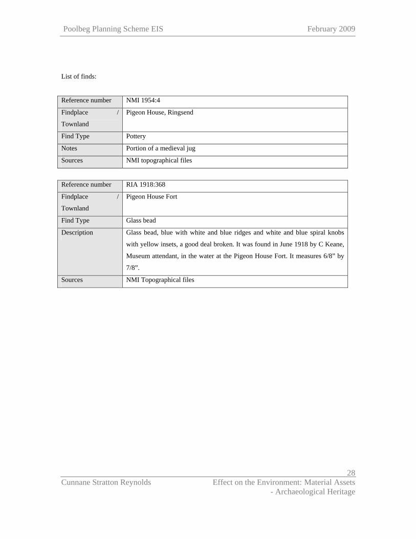
List of finds:
Reference number NMI 1954:4
Findplace /
Townland
Pigeon House, Ringsend
Find Type Pottery
Notes Portion of a medieval jug
Sources NMI topographical files
Reference number RIA 1918:368
Findplace /
Townland
Pigeon House Fort
Find Type Glass bead
Description Glass bead, blue with white and blue ridges and white and blue spiral knobs
with yellow insets, a good deal broken. It was found in June 1918 by C Keane,
Museum attendant, in the water at the Pigeon House Fort. It measures 6/8” by
7/8”.
Sources NMI Topographical files
Page 29
Poolbeg Planning Scheme EIS February 2009
Cunnane Stratton Reynolds Effect on the Environment: Material Assets - Archaeological Heritage
29
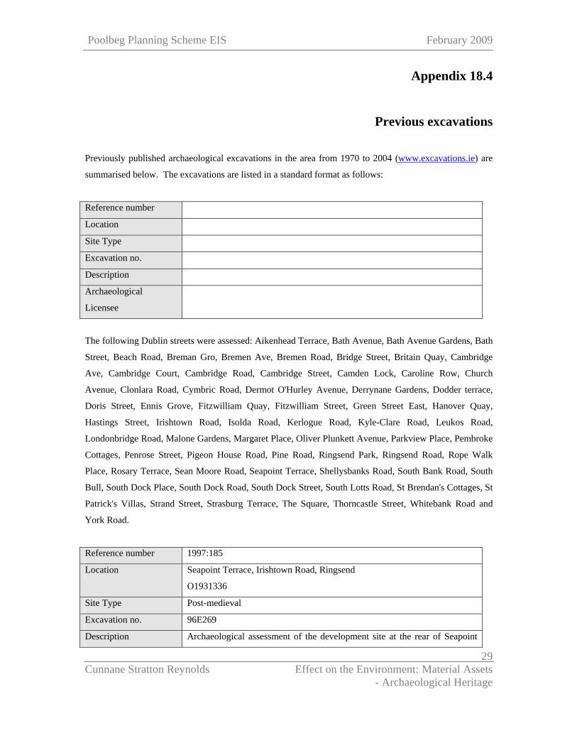
Appendix 18.4
Previous excavations
Previously published archaeological excavations in the area from 1970 to 2004 (www.excavations.ie) are
summarised below. The excavations are listed in a standard format as follows:
Reference number
Location
Site Type
Excavation no.
Description
Archaeological
Licensee
The following Dublin streets were assessed: Aikenhead Terrace, Bath Avenue, Bath Avenue Gardens, Bath
Street, Beach Road, Breman Gro, Bremen Ave, Bremen Road, Bridge Street, Britain Quay, Cambridge
Ave, Cambridge Court, Cambridge Road, Cambridge Street, Camden Lock, Caroline Row, Church
Avenue, Clonlara Road, Cymbric Road, Dermot O'Hurley Avenue, Derrynane Gardens, Dodder terrace,
Doris Street, Ennis Grove, Fitzwilliam Quay, Fitzwilliam Street, Green Street East, Hanover Quay,
Hastings Street, Irishtown Road, Isolda Road, Kerlogue Road, Kyle-Clare Road, Leukos Road,
Londonbridge Road, Malone Gardens, Margaret Place, Oliver Plunkett Avenue, Parkview Place, Pembroke
Cottages, Penrose Street, Pigeon House Road, Pine Road, Ringsend Park, Ringsend Road, Rope Walk
Place, Rosary Terrace, Sean Moore Road, Seapoint Terrace, Shellysbanks Road, South Bank Road, South
Bull, South Dock Place, South Dock Road, South Dock Street, South Lotts Road, St Brendan's Cottages, St
Patrick's Villas, Strand Street, Strasburg Terrace, The Square, Thorncastle Street, Whitebank Road and
York Road.
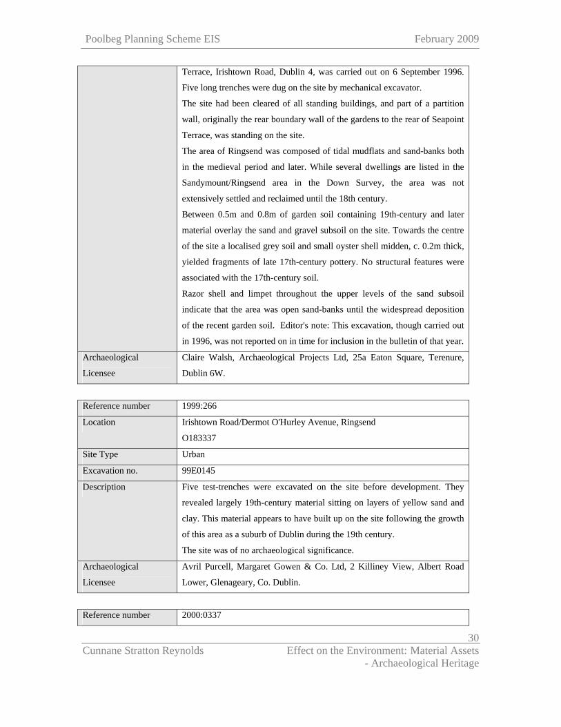
Reference number 1997:185
Location Seapoint Terrace, Irishtown Road, Ringsend
O1931336
Site Type Post-medieval
Excavation no. 96E269
Description Archaeological assessment of the development site at the rear of Seapoint
Page 30
Poolbeg Planning Scheme EIS February 2009
Cunnane Stratton Reynolds Effect on the Environment: Material Assets - Archaeological Heritage
30
Terrace, Irishtown Road, Dublin 4, was carried out on 6 September 1996.
Five long trenches were dug on the site by mechanical excavator.
The site had been cleared of all standing buildings, and part of a partition
wall, originally the rear boundary wall of the gardens to the rear of Seapoint
Terrace, was standing on the site.
The area of Ringsend was composed of tidal mudflats and sand-banks both
in the medieval period and later. While several dwellings are listed in the
Sandymount/Ringsend area in the Down Survey, the area was not
extensively settled and reclaimed until the 18th century.
Between 0.5m and 0.8m of garden soil containing 19th-century and later
material overlay the sand and gravel subsoil on the site. Towards the centre
of the site a localised grey soil and small oyster shell midden, c. 0.2m thick,
yielded fragments of late 17th-century pottery. No structural features were
associated with the 17th-century soil.
Razor shell and limpet throughout the upper levels of the sand subsoil
indicate that the area was open sand-banks until the widespread deposition
of the recent garden soil. Editor's note: This excavation, though carried out
in 1996, was not reported on in time for inclusion in the bulletin of that year.
Archaeological
Licensee
Claire Walsh, Archaeological Projects Ltd, 25a Eaton Square, Terenure,
Dublin 6W.
Reference number 1999:266
Location Irishtown Road/Dermot O'Hurley Avenue, Ringsend
O183337
Site Type Urban
Excavation no. 99E0145
Description Five test-trenches were excavated on the site before development. They
revealed largely 19th-century material sitting on layers of yellow sand and
clay. This material appears to have built up on the site following the growth
of this area as a suburb of Dublin during the 19th century.
The site was of no archaeological significance.
Archaeological
Licensee
Avril Purcell, Margaret Gowen & Co. Ltd, 2 Killiney View, Albert Road
Lower, Glenageary, Co. Dublin.
Reference number 2000:0337
Page 31
Poolbeg Planning Scheme EIS February 2009
Cunnane Stratton Reynolds Effect on the Environment: Material Assets - Archaeological Heritage
31
Location Thorncastle Street, Ringsend
318030 234100
Site Type Urban medieval
Excavation no. 00E0669
Description Monitoring was conducted between 28 August and 6 November on this site
after planning permission had been received to expand an existing
community centre, associated carpark facilities and ancillary works. The site
covers an area of 2000m2 and is bounded by derelict warehouses to the
north, Thorncastle Street to the east, apartments to the south and the River
Dodder to the west. The development is being constructed on the site of a
recognised archaeologically sensitive area (SMR 18:53). Two further
archaeologically sensitive areas are near the site, SMR 18:54 and 18:66.
18:54 is situated c. 400m to the south-east; 18:66 is located along York
Road immediately to the north and east of 18:53.
Surface clearance occurred in two areas, the first within the north-west
portion of the site. In the course of this work, a sacar or minion cannonball
was found within the topsoil. The remainder of the material consisted of
sherds of modern ceramics. The surface of the second area was covered by
layered concrete. No artefacts of an archaeological or historical nature were
uncovered.
A trench was dug adjacent to the north-eastern end of the site to retain a
foul-water sewer. The trench consisted of areas of rubble and old brick
foundations and contained a mixture of red to purple, coarse, gritty soil that
contained a very high quantity of red brick and iron slag. Two other service
trenches were dug. The first was dug to a depth of 0.6–0.8m, the second was
dug to 1.8m.
An old weighing bridge was situated within the southern portion of this area
and was filled entirely with old car parts. Some of the layers expressed a
slightly silty nature, while others were more coarse and sandy. The intense
concentrations of iron slag show that some form of ironworking took place
on or near the site. However, there are no historical records to substantiate
this. Nothing of an artefactual or structural nature was found to indicate the
above period.
It is highly improbable that the find location of the cannonball was the point
Page 32
Poolbeg Planning Scheme EIS February 2009
Cunnane Stratton Reynolds Effect on the Environment: Material Assets - Archaeological Heritage
32
of its original deposition. The ball probably belonged to Cromwell’s arsenal
and may have been misplaced when his army landed here in August 1649. It
is possible that the ball may have been picked up and then discarded from
lack of recognition.
Archaeological
Licensee
Niall Gregory, Flat 1, Main Street, Blessington, Co. Wicklow.
Dublin
Reference number 2000:0338
Location Thorncastle Street, Ringsend
Site Type Urban
Excavation no. 00E0744
Description Testing took place on a disused factory premises that closed down around
1983. The site is bounded on the north by the River Liffey and by York
Road. It is bounded on the west by the confluence of the River Dodder with
the Liffey and the lock system joining the Grand Canal to the Liffey. It is
bounded on the east by Thorncastle Street.
The development involves the demolition of the factory premises and the
erection of a multi-storey building with basement carparking facilities. The
testing was required because the site lies on the periphery of Ringsend
village, and it sought to establish any adverse impacts on any archaeological
remains that may occur on the site.
The standing buildings on the site made it difficult to assess the site fully.
Five test-trenches, previously opened by engineers on the site, were
reopened to examine the stratigraphy and nature of the subsoil. Safety
requirements precluded the digging of certain trenches on the inland portion
of the site. The engineers’ trenches were extended where necessary. All of
the trenches yielded predominantly early modern stratigraphic deposits.
The stratigraphy indicates activity on the site but mainly relating to
reclamation and subsequent industrial activity. All of the evidence,
archaeological and historical, places the activity securely in the 18th to early
20th centuries.
Archaeological
Licensee
Redmond Tobin, Margaret Gowen & Co. Ltd, 2 Killiney View, Albert Road
Lower, Glenageary, Co. Dublin.
Page 33
Poolbeg Planning Scheme EIS February 2009
Cunnane Stratton Reynolds Effect on the Environment: Material Assets - Archaeological Heritage
33
Reference number 2001:415
Location Thorncastle Street, Dublin
Site Type Post-medieval reclamation
Excavation no. 00E0744 ext.
Description Testing was carried out on 27 and 28 March 2001, under an extension to the
original license, in accordance with planning requirements placed on a
development on the site and recommendations contained in a previous
report. Further testing was required as the earlier assessment, carried out in
October 2000, did not satisfactorily assess the archaeological potential of
this site, being limited in its scope by the presence of standing buildings.
The archaeological results were assessed through reopening the engineering
test-pits over the site.
Five trenches were opened. This second phase of testing was to assess the
inland portion of the site for possible archaeological features. The results of
the test-trenches support the conclusions of the previous assessment,
showing conclusively that the whole area has been reclaimed. It would
appear that reclamation on this site commenced in the late 18th century with
the construction of the South Wall, followed by further reclamation during
the development of the Grand Canal Docks, which were completed and
opened in 1796. The Ballast Office records the dredging of 1,621 tons of
material from the Liffey in 1785, and this must have included material
deposited by the River Dodder as a sand bar across the channel of the
Liffey. Both the historical and archaeological evidence agree that this area
was a focus for reclamation and subsequent development.
Archaeological
Licensee
Redmond Tobin, Margaret Gowen & Co. Ltd, 2 Killiney View, Albert Road
Lower, Glenageary, Co. Dublin.
Reference number 2002:0657
Location Ropewalk Place, Ringsend
O179338
Site Type No archaeological significance
Excavation no. 02E0776
Description Test excavation of a site at Ropewalk Place, Ringsend, Dublin 4, was
carried out on 7 June 2002. The area of Ringsend (An Rinn) was tidal
Page 34
Poolbeg Planning Scheme EIS February 2009
Cunnane Stratton Reynolds Effect on the Environment: Material Assets - Archaeological Heritage
34
mudflats and sandbanks in the medieval period and later. Nothing of
archaeological significance was uncovered.
Archaeological
Licensee
Claire Walsh, 27 Coulson Avenue, Rathgar, Dublin 6.
Reference number 2004:0519
Location U2 Tower, Britain Quay, Dublin
O180345
Site Type Urban
Excavation no. 04E0271
Description Monitoring of engineers test pits was undertaken in 2004. The site is to be
developed as a landmark tower, on the junction of the Grand Canal Locks
with the Liffey at Britain Quay, Dublin 4. Eight test-trenches were
excavated mechanically at sites chosen by the engineers. In addition, several
geological bores were undertaken. The borehole results are summarized as
follows: present ground level to 5m, fill with rubble, etc.; 5-11m, river silt;
11-20m, fine silty sand; 20- 29m, rock interface. This indicates a 5m depth
of 18th century dumped deposits. There is little chance of an archaeological
horizon being present below 5m, which is river level.
Archaeological
Licensee
Claire Walsh, 27 Coulson Avenue, Rathgar, Dublin 6.
Reference number 2004:0579
Location Poolbeg Yacht and Boat Club, Pigeon House Road, Dublin
318852 232910
Site Type Marine
Excavation no. 04E0740
Description Monitoring was carried out of dredging work at Poolbeg Yacht and Boat
Club, in association with the development of a marina on the River Liffey in
Dublin Port. The monitoring of back-hoe dredging was achieved through
constant visual inspection of the excavator bucket as it came out of the water
and deposited each load in the barge alongside. In addition, the barge, the
dredger and the excavator’s cab contains a computer screen showing the
image of the surrounding sea-bottom with depths indicated, as well as the
position and depth of the excavator bucket at any time, and this was
Page 35
Poolbeg Planning Scheme EIS February 2009
Cunnane Stratton Reynolds Effect on the Environment: Material Assets - Archaeological Heritage
35
accessible to the archaeologist. This computer also shows the depths to
which the surrounding substrate has been dredged.
The dredged material consisted of two layers. The upper layer consisted of a
soft brown silt with much modern debris. This debris included several
modern mooring blocks, engines and tyres. Three modern vessels were
recorded within this layer. The underlying stratum was a sterile grey silt. No
archaeological stratigraphy or finds were recovered during monitoring.
Archaeological
Licensee
Jacinta Kiely, Eachtra Archaeological Projects, Ballycurreen Industrial
Estate, Kinsale Road, Cork.
Page 36
Poolbeg Planning Scheme EIS February 2009
Cunnane Stratton Reynolds Effect on the Environment: Material Assets - Archaeological Heritage
36
Appendix 18.5
Features of Industrial Archaeological Interest
Features of industrial archaeological interest identified in the Draft Planning Scheme Area are included in
tabular form below (source Dublin City Industrial Heritage Record, 2007). Please note that features
identified in this survey have not been verified in the field.
Site No. Street Classification Map Designations
18-12-118 York Road Boat Slip (Wooden Pier) OS 1907, OS 1935
18-12-151 Pigeon House Road Syphon House OS 1907, OS 1935
18-12-152 Pigeon House Road Dublin Corporation Main
Drainage Pumping Station
OS 1907, OS 1935
19-9-001 Pigeon House Road Boat Slip OS 1864, OS 1908
19-9-004 Pigeon House Road Dublin Corporation Outfall
Works
OS 1908
19-9-005 Pigeon House Road Lifeboat House OS 1908, OS 1936
19-9-006 Pigeon House Road Electricity Works OS 1908, OS 1936
19-9-007 Dublin Harbour Dolphin Cooling Water Intake OS 1936
19-9-008 South Bull, South Wall
Road
Lifeboat House OS 1864, OS 1908, OS
1936
19-9-009 South Bull, South Wall
Road
Sluice House OS 1908, OS 1936
19-9-010 South Bull, South Wall
Road
Causeway OS 1864, OS 1908, OS
1936
19-9-011 White Bank Wharf, South
Bull, South Wall Road
Slip OS 1864, OS 1908, OS
1936
19-9-012 Pigeon House Road (Former) Slip OS 1864, OS 1908, OS
1936