Summaries of Judgments, Advisory Opinions and Orders of the International Court of Justice 1 197. FRONTIER DISPUTE (BURKINA FASO/NIGER) Judgment of 16 April 2013 On 16 April 2013, the International Court of Justice rendered its Judgment in the case concerning the Frontier Dispute (Burkina Faso/Niger). The Court was composed as follows: President Tomka; Vice-President Sepúlveda-Amor; Judges Owada, Abraham, Keith, Bennouna, Skotnikov, Cançado Trindade, Yusuf, Greenwood, Xue, Donoghue, Gaja, Sebutinde, Bhandari; Judges ad hoc Mahiou, Daudet; Registrar Couvreur. * * * The operative paragraph (para. 114) of the Judgment reads as follows: “… THE COURT, (1) Unanimously, Finds that it cannot uphold the requests made in points 1 and 3 of the final submissions of Burkina Faso; (2) Unanimously, Decides that, from the Tong-Tong astronomic marker, situated at the point with geographic co-ordinates 14° 24' 53.2" N; 00° 12' 51.7" E, to the Tao astronomic marker, the precise co-ordinates of which remain to be determined by the Parties as specified in paragraph 72 of the present Judgment, the course of the frontier between Burkina Faso and the Republic of Niger takes the form of a straight line; (3) Unanimously, Decides that, from the Tao astronomic marker, the course of the frontier follows the line that appears on the 1:200,000-scale map of the Institut géographique national (IGN) de France, 1960 edition, (hereinafter the “IGN line”) until its intersection with the median line of the River Sirba at the point with geographic co-ordinates 13° 21' 15.9" N; 01° 17' 07.2" E; (4) Unanimously, Decides that, from this latter point, the course of the frontier follows the median line of the River Sirba upstream until its intersection with the IGN line, at the point with geographic co-ordinates 13° 20' 01.8" N; 01°07' 29.3" E; from that point, the course of the frontier follows the IGN line, turning up towards the north-west, until the point, with geographic co-ordinates 13° 22' 28.9" N; 00° 59' 34.8" E, where the IGN line turns south.
Transcript
Summaries of Judgments, Advisory Opinions and Orders of the International Court of Justice
1
197. FRONTIER DISPUTE (BURKINA FASO/NIGER)
Judgment of 16 April 2013
On 16 April 2013, the International Court of Justice rendered its Judgment in the case concerning the Frontier Dispute (Burkina Faso/Niger).
The Court was composed as follows: President Tomka; Vice-President Sepúlveda-Amor; Judges Owada, Abraham, Keith, Bennouna, Skotnikov, Cançado Trindade, Yusuf, Greenwood, Xue, Donoghue, Gaja, Sebutinde, Bhandari; Judges ad hoc Mahiou, Daudet; Registrar Couvreur.
* * *
The operative paragraph (para. 114) of the Judgment reads as follows:
“… THE COURT,
(1) Unanimously,
Finds that it cannot uphold the requests made in points 1 and 3 of the final submissions of Burkina Faso;
(2) Unanimously,
Decides that, from the Tong-Tong astronomic marker, situated at the point with geographic co-ordinates 14° 24' 53.2" N; 00° 12' 51.7" E, to the Tao astronomic marker, the precise co-ordinates of which remain to be determined by the Parties as specified in paragraph 72 of the present Judgment, the course of the frontier between Burkina Faso and the Republic of Niger takes the form of a straight line;
(3) Unanimously,
Decides that, from the Tao astronomic marker, the course of the frontier follows the line that appears on the 1:200,000-scale map of the Institut géographique national (IGN) de France, 1960 edition, (hereinafter the “IGN line”) until its intersection with the median line of the River Sirba at the point with geographic co-ordinates 13° 21' 15.9" N; 01° 17' 07.2" E;
(4) Unanimously,
Decides that, from this latter point, the course of the frontier follows the median line of the River Sirba upstream until its intersection with the IGN line, at the point with geographic co-ordinates 13° 20' 01.8" N; 01°07' 29.3" E; from that point, the course of the frontier follows the IGN line, turning up towards the north-west, until the point, with geographic co-ordinates 13° 22' 28.9" N; 00° 59' 34.8" E, where the IGN line turns south.
Summaries of Judgments, Advisory Opinions and Orders of the International Court of Justice
2
At that point, the course of the frontier leaves the IGN line and continues due west in a straight line until the point, with geographic co-ordinates 13° 22' 28.9" N; 00° 59' 30.9" E, where it reaches the meridian which passes through the intersection of the Say parallel with the right bank of the River Sirba; it then runs southwards along that meridian until the said intersection, at the point with geographic co-ordinates 13° 06' 12.08" N; 00° 59' 30.9" E;
(5) Unanimously,
Decides that, from this last point to the point situated at the beginning of the Botou bend, with geographic co-ordinates 12° 36' 19.2" N; 01° 52' 06.9" E, the course of the frontier takes the form of a straight line;
(6) Unanimously,
Decides that it will nominate at a later date, by means of an Order, three experts in accordance with Article 7, paragraph 4, of the Special Agreement of 24 February 2009.”
*
* *
Judge Bennouna appended a declaration to the Judgment of the Court; Judges Cançado Trindade and Yusuf append separate opinions to the Judgment of the Court; Judges ad hoc Mahiou and Daudet appended separate opinions to the Judgment of the Court.
*
* *
I. Procedural and factual background of the case (paras. 1-34)
The Court recalls that, by a joint letter of notification dated 12 May 2010, Burkina Faso and the Republic of Niger transmitted to the Registrar a Special Agreement which was signed at Niamey on 24 February 2009 and entered into force on 20 November 2009, whereby they agreed to submit to the Court the frontier dispute between them over a section of their common boundary. Attached to this letter were the Protocol of Exchange of the Instruments of Ratification of the said Special Agreement and an exchange of Notes, dated 29 October and 2 November 2009, placing on record the agreement (“entente”) between the two States on the results of the work of the Joint Technical Commission on Demarcation concerning the demarcated sectors of the frontier running, in the north, from the heights of N’Gouma to the astronomic marker of Tong-Tong and, in the south, from the beginning of the Botou bend to the River Mekrou. The Court further recalls that it was requested, in Article 2 of the said Special Agreement, to determine the course of the boundary between Burkina Faso and Niger in the sector from the astronomic marker of Tong-Tong to the beginning of the Botou bend and to place on record the Parties’ agreement [“leur entente”] on the results of the work of the Joint Technical Commission on Demarcation of the boundary. It then sets out the historical and factual background of the dispute between these two former colonies, which were part of French West Africa until they gained independence in 1960.
Summaries of Judgments, Advisory Opinions and Orders of the International Court of Justice
3
Before examining the dispute between the Parties regarding the course of their common frontier between the astronomic marker of Tong-Tong and the beginning of the Botou bend, the Court deals with the request submitted by Burkina Faso concerning the two demarcated sectors of the frontier.
II. The request concerning the two sectors running, in the north, from the heights of N’Gouma to the Tong-Tong astronomic marker and, in the south, from the beginning of the Botou bend to the River Mekrou (paras. 35-39)
The Court notes that in points 1 and 3 of its final submissions, Burkina Faso requests it to adjudge and declare that its frontier with Niger follows, in the two demarcated sectors, a course which consists of lines linking points whose co-ordinates it provides, which correspond to those recorded in 2009 by the joint mission tasked with conducting surveys based on the work of the Joint Technical Commission. It further notes that Burkina Faso asks the Court to include that course in the operative part of its Judgment, so that the Parties will be bound by it, in the same way that they will be bound with regard to the frontier line in the sector that remains in dispute. The Court observes that, in its final submissions, Niger only requests the Court to draw the frontier between the two States in the section in dispute, which runs from the Tong-Tong astronomic marker to the beginning of the Botou bend. Taking the view that there already exists an agreement between the Parties regarding the two demarcated sectors, Niger is of the opinion that there is no need to include a reference to those sectors in the operative part of the Judgment. However, it does consider that the said agreement should be noted by the Court in the reasoning of its Judgment.
The Court indicates that, when it is seised on the basis of a special agreement, any request made by a party in its final submissions can fall within the jurisdiction of the Court only if it remains within the limits defined by the provisions of that special agreement. However, it considers that the request made by Burkina Faso in its final submissions does not exactly correspond to the terms of the Special Agreement, since that State does not request the Court to “place on record the Parties’ agreement” (“leur entente”) regarding the delimitation of the frontier in the two demarcated sectors, but rather to delimit the frontier according to a line that corresponds to the conclusions of the Joint Technical Commission. According to the Court, however, it is one thing to note the existence of an agreement between the Parties and to place it on record for them; it is quite a different matter to appropriate the content of that agreement in order to make it the substance of a decision of the Court itself. The Court considers that, taken literally, Burkina Faso’s request could therefore be rejected as exceeding the limits of the Court’s jurisdiction as defined by the Special Agreement. It recognizes, however, that it has the power to interpret the final submissions of the Parties in such a way as to maintain them, so far as possible, within the limits of its jurisdiction under the Special Agreement and, consequently, to interpret the final submissions of Burkina Faso as seeking that the Court place on record the agreement of the Parties.
Nevertheless, the Court takes the view that that would not be sufficient to entertain such a request, since it would still have to be verified that the object of that request falls within the Court’s judicial function as defined by its Statute, which is “to decide in
Summaries of Judgments, Advisory Opinions and Orders of the International Court of Justice
4
accordance with international law such disputes as are submitted to it”. The Court notes that, in the present case, neither of the Parties has ever claimed that a dispute continued to exist between them concerning the delimitation of the frontier in the two sectors in question on the date when the proceedings were instituted nor that such a dispute has subsequently arisen. It observes that, if the Parties have appeared to argue differently, it is on the question of whether the “entente” referred to in the Special Agreement has already resulted in an agreement which is legally binding for the two Parties under international law. In its opinion, however, the decisive question is whether a dispute existed between the Parties concerning these two sectors on the date when the proceedings were instituted; it matters little, from the point of view of the judicial function of the Court, whether or not the “entente” reached by the Parties has already been incorporated into a legally binding instrument. Accordingly, the Court considers that Burkina Faso’s request exceeds the limits of its judicial function.
III. The course of the section of the frontier remaining in dispute (paras. 60-112)
A. Applicable law (paras. 60-69) The Court notes that Article 6 of the Special Agreement, entitled “Applicable law”, stipulates that “[t]he rules and principles of international law applicable to the dispute are those referred to in Article 38, paragraph 1, of the Statute of the International Court of Justice, including the principle of the intangibility of boundaries inherited from colonization and the Agreement of 28 March 1987”. It observes that, amongst the rules of international law applicable to the dispute, the above-mentioned provision highlights “the principle of the intangibility of boundaries inherited from colonization and the Agreement of 28 March 1987”. It states that the Special Agreement provides specific indications as to the way in which the above-mentioned principle must be applied. Article 6 of that instrument requires the application of the 1987 Agreement, which binds the Parties and the objective of which is, according to its title, “the demarcation of the frontier between the two countries”. The Court observes that, although the aim of the 1987 Agreement is the “demarcation of the frontier between the two countries” through the installation of markers, it lays down first of all the criteria that must be applied to determine the “course” of the frontier.
The Court notes that the first two articles of that Agreement specify the acts and documents of the French colonial administration which must be used to determine the delimitation line that existed when the two countries gained independence. It observes in this connection that it follows from that Agreement that the Arrêté of 31 August 1927 adopted by the Governor-General ad interim of French West Africa with a view to “fixing the boundaries of the colonies of Upper Volta and Niger”, as clarified by its Erratum of 5 October 1927, is the instrument to be applied for the delimitation of the boundary. The Court states that it must be interpreted in its context, taking into account the circumstances of its enactment and implementation by the colonial authorities. As to the relationship between the Arrêté and its Erratum, the Court notes that, since the purpose of the Erratum is to correct the text of the Arrêté retroactively, it forms an integral part of the latter. For that reason, whenever reference is made to the “Arrêté”, that will signify, unless otherwise indicated, the wording of the Arrêté as amended by the Erratum. The Court further
Summaries of Judgments, Advisory Opinions and Orders of the International Court of Justice
5
observes that Article 2 of the 1987 Agreement provides for the possibility of “the Arrêté and Erratum not suffic[ing]” and establishes that, in that event, “the course shall be that shown on the 1:200,000-scale map of the Institut géographique national de France, 1960 edition” or resulting from “any other relevant document accepted by joint agreement of the Parties”. It points out, however, that the Parties do not consider that they have accepted any relevant document other than the 1960 IGN map.
B. The course of the frontier (paras. 70-112)
1. The course of the frontier between the Tong-Tong and Tao astronomic markers (paras. 72-79)
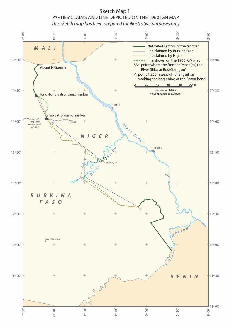
The Court observes that the Parties agree that, in accordance with the Arrêté, their common frontier connects the two points at which the Tong-Tong and Tao astronomic markers are respectively situated. It points out that the Parties do not disagree on the identification or the location of these markers, but on how to connect the two points at which they are situated. It notes that Burkina Faso wants the Court to connect these two points with a straight line, whereas Niger argues in favour of two straight-line segments, one running from the Tong-Tong marker to the Vibourié marker, the other running from the Vibourié marker to the Tao marker. The Court is of the opinion that the colonial administration officials interpreted the Arrêté as drawing, in the sector in question, a straight line between the Tong-Tong and Tao astronomic markers. Accordingly, a straight line connecting the two markers should be regarded as constituting the frontier between Burkina Faso and Niger in the sector in question.
2. The course of the frontier between the Tao astronomic marker and the River Sirba at Bossébangou (paras. 80-99)
The Court notes that it is not possible to determine from the Arrêté how to connect the Tao astronomic marker to “the River Sirba at Bossébangou”; the Arrêté merely states that the “line . . . turns [‘s’infléchit’] towards the south-east, cutting the Téra-Dori motor road at the Tao astronomic marker . . ., and reaching the River Sirba at Bossébangou”. The Court observes that, in Burkina Faso’s opinion, this lack of detail should be interpreted as meaning that the two above-mentioned points must be connected by a straight line. It notes that, in Niger’s view, this lack of detail demonstrates, on the other hand, that “the Arrêté and Erratum [do] not suffice”, within the meaning of the 1987 Agreement, making it necessary in principle to follow the line as drawn on the 1960 IGN map for the section of the frontier in question, with, however, a slight deviation to the west in two segments corresponding to the Petelkolé frontier post and to the Oussaltane encampment, so as to leave those two localities in Niger’s territory, whereas the said line locates them on the Upper Volta side of the inter-colonial boundary. The Court observes that, according to Niger, this is to give precedence to the effectivités as observed at the critical dates of independence. It notes that, in addition, Niger considers that it is also necessary to deviate from the 1960 IGN map in order to define the endpoint of the frontier line in the sector in question, since the line should not end at Bossébangou, but descend only as far as a point situated some 30 km to the north-west of that village, and, from that point, turn towards the south-west, thereby leaving an extensive area around Bossébangou entirely in Niger’s territory.
Summaries of Judgments, Advisory Opinions and Orders of the International Court of Justice
6
The Court begins by examining the question of the endpoint of the frontier line in the sector in question. It notes that the Arrêté provides expressis verbis that the inter-colonial boundary continues as far as the River Sirba. In conclusion, the Court can only find that the frontier line necessarily reaches the River Sirba at Bossébangou.
The Court then turns to the question of how the “Tao astronomic marker” is to be connected to “the River Sirba at Bossébangou” in order to draw the frontier. It begins by stating that the Decree of the President of the French Republic of 28 December 1926 “transferring the administrative centre of the Colony of Niger and providing for territorial changes in French West Africa”, on the basis of which the Arrêté was adopted, constitutes an important element of the context within which that Arrêté was issued. It observes that the object of the said Decree was twofold: to transfer certain cercles and cantons from the Colony of Upper Volta to the Colony of Niger and to empower the Governor-General of French West Africa to draw the new inter-colonial boundary between Niger and Upper Volta. It notes that, to this end, the Governor-General sought to identify the pre-existing boundaries of the cercles and cantons, but that there was nothing to indicate that they followed a straight line in the sector in question. It observes that, in such a case, it would have been easy to plot this line on a map. The Court then observes that, with respect to the village of Bangaré, there are sufficient documents subsequent to the Arrêté to establish that, during the relevant colonial period and until the critical date of independence, this village was administered by the authorities of the Colony of Niger, as the latter claims. According to the Court, this consideration supports the conclusion that the Arrêté should not be interpreted, and in fact was not interpreted in the colonial period, as drawing a straight line between Tao and Bossébangou.
The Court concludes from the foregoing considerations that the Arrêté must be regarded as “not suffic[ient]”, within the meaning of the 1987 Agreement, in respect of the sector running from the Tao astronomic marker to the River Sirba at Bossébangou. Recourse must therefore be had to the line appearing on the 1960 IGN map. Moreover, it declares that it cannot uphold Niger’s requests that the said line be shifted slightly at the level of the localities of Petelkolé and Oussaltane, on the ground that these were purportedly administered by Niger during the colonial period. The Court considers that, once it has been concluded that the Arrêté is insufficient, and in so far as it is insufficient, the effectivités can no longer play a role in the present case. In conclusion, the Court finds that, in the sector of the frontier that runs from the Tao astronomic marker to “the River Sirba at Bossébangou”, the line shown on the 1960 IGN map should be adopted.
3. The course of the frontier in the area of Bossébangou (paras. 100-107)
The Court considers that, in order to complete the determination of the frontier line coming from the Tao astronomic marker, it is necessary to specify its endpoint where it reaches “the River Sirba at Bossébangou”. It states that, according to Burkina Faso, this point is located where the straight-line segment which runs from Tao to Bossébangou intersects with the right bank of the Sirba close to that village. It notes that, for its part, Niger does not take a view on the matter, on account of its argument that the frontier line from Tao does not continue as far as the River Sirba, but turns towards the south-west at the tripoint between the cercles of Dori, Say and Tillabéry, some 30 km before it reaches that river.
Summaries of Judgments, Advisory Opinions and Orders of the International Court of Justice
7
According to the description in the Arrêté, it is clear, in the opinion of the Court, that the frontier line ends at the River Sirba and not at the village of Bossébangou. The endpoint of the frontier in this section must therefore be situated in the Sirba or on one of its banks. However, the use of the term “reach” (“atteindre”) in the Arrêté does not suggest that the frontier line crosses the Sirba completely, meeting its right bank. Moreover, the Court considers that there is no evidence before it that the River Sirba in the area of Bossébangou was attributed entirely to one of the two colonies. It notes in this regard that the requirement concerning access to water resources of all the people living in the riparian villages is better met by a frontier situated in the river than on one bank or the other. Accordingly, the Court concludes that, on the basis of the Arrêté, the endpoint of the frontier line in the area of Bossébangou is located in the River Sirba. This endpoint is more specifically situated on the median line because, in a non-navigable river with the characteristics of the Sirba, that line best meets the requirements of legal security inherent in the determination of a boundary.
The Court notes that, in its original wording, the Arrêté situated the meeting-point of the frontier line from Tao with the River Sirba further downstream and stated that this line “then joins the River Sirba”. It was clear, according to that wording, that the frontier was supposed to follow that river upstream for a certain distance. The Court contends that, while the language of the Erratum is less clear, it nevertheless specifies that, after reaching the Sirba, the frontier line “almost immediately turns back up towards the north-west”. It can be concluded, therefore, that the Erratum did not seek to amend the Arrêté entirely on this point and that it implies that the line must follow the Sirba for a short distance. For the reasons given above, the Court considers that the frontier follows the median line of the Sirba.
The Court observes that the corrected wording of the Arrêté, according to which the frontier line “almost immediately turns back up towards the north-west”, does not establish the precise point at which that line leaves the River Sirba in order to “[turn] back up”. There is no indication in the text in that regard except for the fact that the point is located close to Bossébangou. Similarly, once the frontier leaves the Sirba, its course is indicated in the Arrêté in a manner that makes it impossible to establish the line accurately. According to the Court, it can therefore only be concluded that the Arrêté does not suffice to determine the frontier line in this section and that it is thus necessary to refer to the 1960 IGN map in order to define precisely the point where the frontier line leaves the River Sirba and “turns back up towards the north-west” and the course that it must follow after that point.
The Court indicates that, according to the Arrêté, the frontier line, after turning up towards the north-west, “turn[s] back to the south, . . . [and] again cuts the Sirba at the level of the Say parallel”. It considers that, once that place has been determined, the meridian passing through it can be followed northwards until the parallel running through the point where the line drawn on the 1960 IGN map turns back to the south. The Court observes that, whereas, in its original wording, the Arrêté referred to “a line starting approximately from the Sirba at the level of the Say parallel”, the text of the Erratum is much more categorical in this respect and thus cannot be regarded as insufficient. It refers to the intersection between the parallel passing through Say and the River Sirba. According to
Summaries of Judgments, Advisory Opinions and Orders of the International Court of Justice
8
the Court, it can even be deduced that this point, called point I on sketch-maps 3 and 4, is located on the right bank of the Sirba (at the point with geographic co-ordinates 13º 06' 12.08" N; 00º 59' 30.9" E), since, according to the Erratum, the frontier line coming from the north cuts the river here before continuing towards the south-east. In the view of the Court, the frontier thus drawn from the area of Bossébangou to the point where the Say parallel cuts the River Sirba forms what might be termed a “salient”, in accordance with the description contained in the Arrêté. Niger acknowledges that, in contrast, the frontier line which it proposes does not, for its part, “create a salient in this area”.
The Court concludes that the frontier line, after reaching the median line of the River Sirba while heading towards Bossébangou, at the point with geographic co-ordinates 13° 21' 15.9" N; 01° 17' 07.2" E, called point SB on sketch-maps 1, 2, 3 and 4, follows that line upstream until its intersection with the IGN line, at the point with geographic co-ordinates 13° 20' 1.8" N; 01° 07' 29.3" E, called point A on sketch-maps 3 and 4. From that point, the frontier line follows the IGN line, turning up towards the north-west until the point, with geographic co-ordinates 13° 22' 28.9" N; 00° 59' 34.8" E, called point B on sketch-map 3, where the IGN line markedly changes direction, turning due south in a straight line. As this turning point B is situated some 200 m to the east of the meridian which passes through the intersection of the Say parallel with the River Sirba, the IGN line does not cut the River Sirba at the Say parallel. However — the Court notes — the Arrêté expressly requires that the boundary line cut the River Sirba at that parallel. The frontier line must therefore depart from the IGN line as from point B and, instead of turning there, continue due west in a straight line until the point, with geographic co-ordinates 13° 22' 28.9" N; 00° 59' 30.9" E, called point C on sketch-maps 3 and 4, where it reaches the meridian which passes through the intersection of the Say parallel with the right bank of the River Sirba. The frontier line then runs southwards along that meridian until the said intersection, at the point with geographic co-ordinates 13° 06' 12.08" N; 00° 59' 30.9" E, called point I on sketch-maps 3 and 4.
4. The course of the southern part of the frontier (paras. 108-112)
The Court observes that the intersection of the River Sirba with the Say parallel is the starting-point of another section of the frontier. According to the Arrêté, “[f]rom that point the frontier, following an east-south-east direction, continues in a straight line up to a point located 1,200 m to the west of the village of Tchenguiliba”. It notes that this latter point has been identified in a consistent manner by the Parties, since it marks the start of the southern section of the already demarcated portion of the frontier. The Court recalls that the Arrêté specifies that, in this section, the frontier “continues in a straight line”. It considers that it is precise in that it establishes that the frontier line is a straight-line segment between the intersection of the Say parallel with the Sirba and the point located 1,200 m to the west of the village of Tchenguiliba. According to the Court, it cannot therefore be said that the Arrêté does not suffice with respect to this section of the frontier.
The Court concludes that, in this section of the frontier, the line consists of a straight-line segment between the intersection of the Say parallel with the right bank of the River Sirba and the beginning of the Botou bend.
Summaries of Judgments, Advisory Opinions and Orders of the International Court of Justice
9
*
Having determined the course of the frontier between the two countries, the Court expresses its wish that each Party, in exercising its authority over the portion of the territory under its sovereignty, should have due regard to the needs of the populations concerned, in particular those of the nomadic or semi-nomadic populations, and to the necessity to overcome difficulties that may arise for them because of the frontier. The Court notes the co-operation that has already been established on a regional and bilateral basis between the Parties in this regard, in particular under Chapter III of the 1987 Protocol of Agreement, and encourages them to develop it further.
IV. Nomination of experts (para. 113)
The Court observes that, in Article 7, paragraph 4, of the Special Agreement, the Parties requested the Court to nominate, in its Judgment, three experts to assist them as necessary in the demarcation of their frontier in the area in dispute. It notes that both Parties reiterated this request in the final submissions presented at the hearings. The Court is ready to accept the task which the Parties have thus entrusted to it. However, having regard to the circumstances of the present case, the Court is of the opinion that it is inappropriate at this juncture to make the nominations requested by the Parties. It will do so later by means of an Order, after ascertaining the views of the Parties, particularly as regards the practical aspects of the exercise by the experts of their functions.
* * *
Declaration of Judge Bennouna While supporting the Court’s decision, Judge Bennouna recalls that, according to the jurisprudence of the Court, colonial law is not taken into account as such, but only as a factual element or as evidence of the colonial heritage.
For Judge Bennouna, this distinction has proved difficult to apply in this case inasmuch as the Special Agreement requested the Court to rely on a relatively succinct arrêté of the Governor-General of French West Africa of 1927, whose sole concern was to separate entities depending on the same colonial power in order to improve territorial administration.
Separate opinion of Judge Cançado Trindade 1. In his Separate Opinion, composed of 12 parts, Judge Cançado Trindade begins by explaining that, although he has concurred with his vote to the adoption of the present Judgment in the case concerning the Frontier Dispute between Burkina Faso and Niger, where the ICJ has, at the request of the Parties, determined the course of their frontier, there are certain points, to which he attributes much importance, which are not properly reflected in the reasoning of its Judgment, or which have not been sufficiently stressed therein. He thus feels bound, and cares, to leave on the records the foundations of his own personal
Summaries of Judgments, Advisory Opinions and Orders of the International Court of Justice
10
position thereon, particularly in respect of the relationship between the territory at issue and the local (nomadic and semi-nomadic) populations.
2. His reflections, on the basis of the documentation conforming the dossier of the present case (not wholly reflected in the present Judgment), pertain, — as he indicates in part I, — to: a) provisions of treaties (after independence in 1960) expressing concern with the local populations; b) concern of the Parties with the local populations in the written phase of proceedings; c) communiqués (after independence in 1960) expressing concern with the local populations; d) views of the Parties concerning villages; e) concern of the Parties with the local populations in the oral phase of proceedings (first and second rounds of oral arguments); f) concern of the Parties with the local populations in the responses of the Parties to questions from the bench; and g) the tracing of the frontier line in the IGN map.
3. He observes that there is a wealth of materials, in the dossier of the present case, in the responses provided by the Parties to questions from the bench, not fully or sufficiently reflected in the present Judgment of the Court. He then focuses on: a) the human factor and frontiers; b) admission by the Parties that they are bound by their pledge to co-operation in respect of local populations (in multilateral African fora, and in bilateral agreements, conforming the régime of transhumance); and c) population and territory together, conforming a “system of solidarity” (encompassing transhumance and the “system of solidarity”; people and territory together; and solidarity in the jus gentium). He then presents his concluding observations.
4. He recalls that, in the present Judgment in the case of the Frontier Dispute between Burkina Faso and Niger, the ICJ begins by pointing out that the dispute at issue is set within an historical context marked by the accession to independence of the two contending Parties (Burkina Faso and Niger), which were formerly part of French West Africa (para. 12). Judge Cançado Trindade ascribes particular importance to the documents after their independence in 1960. He finds it commendable that the contending Parties, Burkina Faso and Niger, deemed it fit to insert, into treaties they concluded after their independence in 1960, provisions expressing their concern with the local populations (part II).
5. Likewise, he singles out the concern expressed by the contending Parties with the local populations in the written phase of proceedings, and examines each of the arguments they advanced to that effect (part III). The same concern is found in communiqués between Burkina Faso and Niger (after independence in 1960), concerning freedom of movement of local populations (free circulation of persons and goods; trade, transportation and customs) (part IV). He then examines the views advanced by the Parties concerning villages in the frontier region (part V).
6. Judge Cançado Trindade then reviews the concern expressed by the contending Parties with the local populations in the course of the oral phase of proceedings (first and second rounds of oral arguments — part VI). To the questions he put to the contending Parties at the end of the public sittings before the Court, on 17 October 2012, both Burkina Faso and Niger, in three rounds of responses, have provided the Court with
Summaries of Judgments, Advisory Opinions and Orders of the International Court of Justice
11
considerable additional information (a file of 140 pages), containing relevant details for the consideration of the present case (part VII).
7. He considers certain passages of their responses to be particularly enlightening, — in particular those pertaining to nomadic populations. Transhumance movements were dictated by nature and natural resources, without taking into account border lines between States; they were based on solidarity. The free circulation of local populations and goods between the two States was said to be guaranteed by the bilateral and multilateral agreements concerning the liberty of movement and access to natural resources, to which Niger and Burkina Faso are Parties; they have been able to keep their modus vivendi in this regard.
8. The Parties’ responses have submitted that: a) there are nomads and semi-nomads located in the border area and in the region; b) the nomadic populations move across the areas where any of the frontiers claimed by the Parties would be located; c) the Parties are willing and are bound (by their membership in regional organizations and by their bilateral engagements) to continue to guarantee free movement to the nomadic populations (para. 46). In this light, Judge Cançado Trindade ponders that “any frontier to be determined does not seem likely to have an impact on the population, as long as both States continue to guarantee the free movement to the nomads and semi-nomads, and their living conditions do not change as a consequence of the fixing of the frontier (by the Court)” (para. 47).
9. Judge Cançado Trindade then observes (part VIII) that, in the area between the Tao astronomic marker and Bossébangou, the IGN line appears, “from the perspective of the relations between people and territory, as the appropriate one” (para. 61). All evidence available in the dossier of the present case, as well as in the archives of this Court, points to the fact that the IGN line was drawn taking into account the consultations undertaken in loco by IGN cartographers with village chiefs and local people. Judge Cançado Trindade then states that
“People and territory stand together; it is clear, in contemporary jus gentium, that territorial or frontier disputes cannot be settled making abstraction of the local populations concerned. (...) [T]he IGN line, and indeed the course of the frontier determined by the Court in the cas d’espèce in the area between the Tao astronomic marker and Bossébangou, cuts across the width of the areas of population movements today in a balanced way, equitably within the orbit of their present-day movements’ areas” (para. 62).
10. In the next part, on the human factor and frontiers (part IX), Judge Cançado Trindade refers to studies by historians and anthropologists in support of his view that, in cases like the present one, concerning frontiers with nomadic and semi-nomadic populations, “people and territory go together” (para. 63). In his perception, “in the determination of frontiers in regions inhabited by human groups of such dense cultural features, one should not simply draw entirely and admittedly ‘artificial’ lines, overlooking the human element”; the centrality, in his view, is of human beings (para. 69).
Summaries of Judgments, Advisory Opinions and Orders of the International Court of Justice
12
11. In the present Judgment on the Frontier Dispute case between Burkina Faso and Niger, the Court has expressed “its wish” that each Party has due regard to the needs of the population concerned, in particular those of the nomadic or semi-nomadic populations (para. 112). Judge Cançado Trindade finds this “very reassuring”, as, in effect, the contending Parties themselves have, in response to his questions, indicated that they regard themselves bound to do so, by virtue of their acknowledgment of their duty of co-operation in respect of local populations (in particular nomadic and semi-nomadic ones), as manifested in multilateral African fora, as well as in bilateral agreements, conforming the régime of transhumance (with freedom of movement of those local populations across their borders — part X).
12. The contending Parties indicated that the living conditions of the local populations will not be affected by the tracing of the frontier line between them. They confirmed their understanding of the conformation of a régime of transhumance as a true “system of solidarity” (para. 87) (part XI). Judge Cançado Trindade observes that the ICJ now sees that people and territory go together:
“the latter cannot make abstraction of the former, in particular in cases of such a cultural density as the present one. After all, since the time of its ‘founding fathers’, the law of nations (jus gentium) has born witness of the presence of solidarity in its corpus juris” (para. 87).
13. Judge Cançado Trindade points out that, “even a classic subject as territory”, is seen today — even by the ICJ — as going together with the population: thus, in its Order on Provisional Measures of Protection (of 18 July 2011) in the case of the Temple of Preah Vihear (request for interpretation, Cambodia versus Thailand), the ICJ approached territory together with the (affected) population, and ordered, — in an unprecedented way in its case-law, — the creation of a demilitarized zone in the surroundings of the aforementioned Temple (near the borderline between the two countries — para. 89).
14. Underlying this jurisprudential construction, — he added, — “is the principle of humanity, orienting the search for the improvement of the conditions of living of the societas gentium and the attainment and realization of the common good (...), in the framework of the new jus gentium of our times” (para. 90). The ICJ’s 2011 decision in the case of the Temple of Preah Vihear is not the only example to this effect. Reference could further be made to a couple of other recent ICJ decisions acknowledging likewise the need to take into account people and territory together.
15. For example, earlier on, in its Judgment (of 13 July 2009) on the Dispute relating to Navigational and Related Rights (Costa Rica v. Nicaragua), the ICJ upheld the customary right of fishing for subsistence (paras. 143-144) of the inhabitants of both margins of the River San Juan. Such fishing for subsistence was never objected to (by the respondent State); and, ultimately, those who fish for subsistence are not the States, but rather the “human beings affected by poverty” (para. 92). Shortly afterwards, in its Judgment (of 20 April 2010) in the case concerning the Pulp Mills on the River Uruguay (Argentina v. Uruguay), the ICJ, in examining the arguments and evidence produced by the
Summaries of Judgments, Advisory Opinions and Orders of the International Court of Justice
13
Parties (on the environmental protection in the River Uruguay), took into account aspects pertaining to the affected local populations, and the consultation to these latter (para. 93).
16. Judge Cançado Trindade then evokes the treatment of the “natural precept” of solidarity in the writings of one of the founding fathers on the law of nations, Francisco Suárez (para. 97), in his masterful De Legibus, Ac Deo Legislatore (1612), preceded by the recta ratio in the writings of Cicero (De Legibus, 52-43 b.c.): “solidarity and mutual interdependence are always present in the regulation of the relations among the members of the universal societas” (para. 98). And he ponders that “solidarity has always had a place in the jus gentium, in the law of nations. And the circumstances of the cas d’espèce before the ICJ between Burkina Faso and Niger bear witness of that today, in so far as their nomadic and semi-nomadic (local) populations are concerned” (para. 98).
17. Judge Cançado Trindade then concludes (part XII) that the basic lesson to be extracted from the present case of the Frontier Dispute between Burkina Faso and Niger is that “it is perfectly warranted and viable to determine a frontier line keeping in mind the needs of the local populations” (para. 99). Law “cannot be applied mechanically” (para 104), and the law of nations cannot be adequately approached from an exclusive inter-State paradigm. “After all, in historical or temporal perspective, nomadic and semi-nomadic, as well as sedentary, populations have largely antedated the emergence of States in classic jus gentium” (para. 104).
18. States, — he adds, — historically “took shape, in order to take care of human beings under their respective jurisdictions, and to strive towards the common good. States have human ends. Well beyond State sovereignty, the basic lesson to be extracted from the present case is, in my perception, focused on human solidarity, pari passu with the needed juridical security of frontiers. This is in line with sociability, emanating from the recta ratio in the foundation of jus gentium. Recta ratio marked presence in the thinking of the “founding fathers” of the law of nations, and keeps on echoing in human conscience in our days” (para. 105).
Separate opinion of Judge Yusuf
1. Judge Yusuf appends a separate opinion to the judgment to take up “certain issues, which the Court did not adequately address in the reasoning of the Judgment, particularly as regards the applicable principles invoked by the Parties in their pleadings before the Court (see paragraph 63 of the Judgment)”.
2. Judge Yusuf states that uti possidetis juris and the OAU/AU principle on respect of borders should not be treated as identical or equivalent. The two principles must be distinguished in light of their different origins, purposes, legal scope and nature. The Court should have cleared up this confusion in the present Judgment. It should have also addressed the issue whether or not both principles have an effective role to play in the present case.
3. The assumption that the two principles are equivalent originates from a statement of a Chamber of the Court in Frontier Dispute ((Burkina Faso/Republic of Mali) Judgment, I.C.J. Reports 1986, pp. 565-566, para. 22) which held that the OAU Charter made
Summaries of Judgments, Advisory Opinions and Orders of the International Court of Justice
14
“indirect reference” to uti possidetis and that the 1964 Cairo Resolution of the OAU “deliberately defined and stressed the principle”. This statement was unchallenged in subsequent judgments concerning African boundary disputes.
4. Judge Yusuf notes that none of the official documents of the OAU or of its successor organization, the AU, relating to African conflicts, territorial or boundary disputes, refers to the principle of uti possidetis juris or mentions it in any manner. The diversity of the boundary régimes which existed on the African continent at the time of independence, and the aversion of the newly-independent African States to the legitimization of colonial law in inter-African relations, led the OAU, and later the AU, to craft its own principle, the legal scope and nature of which is different from uti possidetis juris. Thus, the lack of reference to uti possidetis was not due to a lack of awareness by the OAU/AU member States of the existence of uti possidetis juris as a principle or of its use by the Spanish-American Republics following their own decolonization a century earlier. Rather, different situations, and historical circumstances, dictated the adoption of different legal rules and principles.
5. The principle of respect for boundaries enshrined in the Cairo Resolution of 1964 and in Article 4 (b) of the Constitutive Act of the AU places the boundaries existing at the time of independence in a “holding pattern”, particularly to avoid armed conflict over territorial claims, until a satisfactory and peaceful solution is found by the Parties to a territorial dispute in conformity with international law, or until such time as closer integration and unity is achieved among all (or some) African States in keeping with the Pan-African vision. As such, the principle implies a prohibition of the use of force in the settlement of boundary disputes and an obligation to refrain from acts of seizure of a portion of the territory of another African State. It does not, however, establish a particular method for the delimitation of boundaries, nor does it constitute a criterion for the ascertainment of the pedigree of boundary lines.
6. Judge Yusuf also notes that title to territory is a central aspect of the uti possidetis juris principle, which relies on a clear dichotomy between legal title and effectivités, whereby the title, if it exists, will trump the effectivités or the effective possession of the territory. In Latin America, the relevant title was the Spanish legislation of the time, which served to convert formerly internal boundaries into international ones. The OAU/AU principle of respect for boundaries, on the other hand, is a broader principle which calls for the respect of the post-independence frontiers of African States, pending the resolution of any bilateral disputes, in order to safeguard peace and stability in the continent. It does not rely on, or refer to, the distinction between title and effectivités, nor does it confer preference on one over the other.
7. The relationship between title and effectivités in the determination of the boundary to be respected was never spelled out or even mentioned in OAU or AU documents. In view of the diversity and complexity of the process of independence of African States, the varied legal régimes under which the delimitation of their boundaries was carried out before independence (e.g., international treaties, administrative boundaries, trusteeship agreements), and the sharply divided opinions among African States at the time of independence, both the OAU and the AU deliberately refrained from engaging in a
Summaries of Judgments, Advisory Opinions and Orders of the International Court of Justice
15
detailed consideration of such legal issues as whether title to territory, or effectivités should prevail. Similarly, these organizations declined to lay down, as part of the public law of Africa, a specific peaceful method applicable to the settlement of all potential boundary disputes among all African States, or to the determination of the course of such boundaries.
8. For Judge Yusuf, there is no doubt that the principle of uti possidetis juris has served many advantageous functions in Latin America over the years, and continues to play a useful role in the settlement of boundary disputes in other parts of the world. It cannot, however, be considered as a synonym of the principle endorsed by the OAU in 1964, and later inscribed in the Constitutive Act of the AU, a principle which bars the alteration of existing boundaries by force pending the peaceful settlement of disputes between African States.
9. Judge Yusuf then addresses the relationship between uti posidetis juris and territorial integrity. In the judge’s view, the Chamber of the Court in Frontier Dispute (Burkina Faso/Republic of Mali) erred by interpreting the reference to territorial integrity in the OAU Charter as an “indirect” reference to uti possidetis. These distinct principles of international law must not be confused. The reference in the Cairo Resolution to Article III, paragraph 3, of the OAU Charter, may be construed as a reference to the inviolability of boundaries which is implicit in the principle of territorial integrity, but cannot be taken to have “deliberately defined and stressed the principle of uti possidetis juris contained only in an implicit sense in the Charter of their organization”, as stated by the Chamber of the Court. Inviolability does not, however, signify the invariability or intangibility of frontiers; rather, it means that territorial adjustments must be effected by mutual consent.
10. Finally, Judge Yusuf notes that the present case differs from the earlier cases in so far as the Parties to it concluded an agreement in 1987 delimiting their common boundary. The Court is required only to interpret and apply this agreement. It is not required to determine what constituted for each of the Parties the colonial heritage to which the uti possidetis was to apply. The Parties had already specified that in their own delimitation agreement. The principle of uti possidetis juris has therefore no role to play in the present case.
Separate opinion of Judge ad hoc Mahiou
While subscribing to the Court’s overall approach and to most of the findings reached by it in the present case, Judge ad hoc Mahiou makes a few observations on certain points regarding which the Court’s position calls for further refinements and clarifications. These points relate, on the one hand, to the status of the various documents invoked in the course of the proceedings and, on the other, to the status of the effectivités or, more precisely, their place and role in determining the different sections of the frontier.
The delimitation of the frontier is based on the application and interpretation of the provisions of the Decree of 28 December 1926, the Arrêté of 31 August 1927 and the Erratum of 5 October 1927, the 1960 IGN map and the effectivités on the ground. These texts, documents and effectivités show that the course of the frontier is a combination of straight lines and sinuosities that takes account of the inter-colonial boundaries and the
Summaries of Judgments, Advisory Opinions and Orders of the International Court of Justice
16
effectivités at the date of the independence of Niger and of Burkina Faso. It is a matter of regret that the Court fails to give due place to those effectivités.
Separate opinion of Judge ad hoc Daudet
The separate opinion of Judge ad hoc Daudet focuses on points 3 and 4 of the operative clause of the Judgment.
With respect to point 3, concerning the course of the frontier between the Tao astronomic marker and the River Sirba at Bossébangou, Judge ad hoc Daudet believes that the Court was right to have recourse to the 1960 IGN map in order for the boundary to be determined. In his view, however, a straight-line course nevertheless remains plausible and the arguments put forward by the Court in favour of recourse to the map and its sinuous line give rise to a number of questions on his part.
The Court took the view that, if the 1927 Arrêté had opted for a straight line here, it would have said so specifically, as it had for other sections, and since this was not the case, it is difficult to accept that the line is straight here. Judge ad hoc Daudet acknowledges that this a contrario argument is sound. However, he puts forward several grounds which, in his view, weaken that argument, starting with the inherent limits of any a contrario reasoning. Account should also be taken of the characteristics of the sections in question: the section running from Tao to the River Sirba at Bossébangou comes immediately after a straight line, whose course it continues and which it does in accordance with normal colonial practice, whereas, elsewhere, the lines expressly described as straight by the Arrêté are preceded by meandering portions (like the course of the Sirba) or by significant changes of direction. Judge ad hoc Daudet also observes that, while it is true that the “consensual line” has ceased to be applicable between the Parties, that line, which was deemed pertinent by the Parties at one time, was straight.
He then disagrees with the Court’s analysis of the terms of the 1926 Decree of the President of the French Republic, the basis of the 1927 Arrêté, and its analysis of the nature of the powers accorded to the Governor-General. In contrast to the Court, Judge ad hoc Daudet believes that the Decree gives the Governor-General broad powers to try to fix the boundaries between the two colonies and implies that the Arrêté itself has a constitutive character.
Finally, unlike the Court, Judge ad hoc Daudet does not consider that, in the case of the village of Bangaré, account should be taken, as it is by the Court, “of the practice followed by the colonial authorities concerning the implementation of the Arrêté”. To his mind, the reasoning in the case of Bangaré should not be different to that applied in the Judgment to Oussaltane and Petelkolé, for which recourse to the effectivités is rejected.
However, and irrespective of his disagreements with the Court’s reasoning, Judge ad hoc Daudet believes that while, on the basis of the Arrêté — in so far as its laconic character allows for its interpretation — a straight line is plausible, this cannot be established with any certainty, and he admits that other interpretations are just as conceivable. This proves that the Arrêté does “not suffice” to determine one line or another and, under the terms of the Special Agreement, calls for recourse to the 1960 IGN map.
Summaries of Judgments, Advisory Opinions and Orders of the International Court of Justice
17
With respect to point 4 of the operative clause, Judge ad hoc Daudet does not share the Court’s interpretation regarding the endpoint of the line at the River Sirba at Bossébangou. This point then determines the course of the line as it turns back up the Sirba, up to the point where it must leave the river in order to leave to Niger the “salient which includes four villages”. In order to be able to decide that the frontier follows the median line of the river, the Court interprets the Arrêté in such a way that the term “reach” (“atteindre”) (the Sirba at Bossébangou) “does not suggest that the frontier line crosses the Sirba completely, meeting its right bank”, meaning that the endpoint may be situated in the middle of the river, “better me[eting]” the “requirement concerning access to water resources of all the people living in the riparian villages”. The Court’s choice is fully justified from the point of view of equity. However, the Court is not called upon to draw an equitable frontier, but a frontier based on the 1927 Arrêté or, should the latter not suffice, on the 1960 IGN map. Consequently, without completely dismissing such considerations of equity, the Court has tried, although not entirely successfully, to keep its reasoning within the framework of the Arrêté.
Judge ad hoc Daudet therefore has some reservations, first and foremost with respect to the content of the Court’s interpretation of the Arrêté, since he sees no justification, in this context, for the meaning attributed by the Court to the verb “reach” and, in fact, considers that, since the Arrêté states that the line “reach[es] the River Sirba at Bossébangou”, it must therefore continue as far as the right bank of the river, where that village is located. In order to reach that location, the line must thus have crossed (and will cross again later) the river completely. It is from that point that the line must continue, thus along the right bank, as it turns back up the river. This view, moreover, is confirmed by the line shown on the 1960 IGN map, where crosses cut across the entire width of the River Sirba at Bossébangou and run along the right bank of the river, before cutting it again, in order to create the salient comprising the four villages. According to Judge ad hoc Daudet, by deciding otherwise, the Court has in fact ruled on the basis of equity, while trying to keep its reasoning within the framework prescribed by the Special Agreement, i.e., by applying the Arrêté according to its interpretation thereof. He wonders, however, whether the Court could have opted for delimitation along the bank, which he believes is more consistent with the terms of the Arrêté, and encouraged the States to put in place co-operation mechanisms (in the spirit of paragraph 112 of the Judgment), mitigating the inequitable character of that line and encouraging the shared use of water resources. In spite of these reservations, Judge ad hoc Daudet nevertheless voted in favour of point 4 of the operative clause; he did so because he accepts that such a literal interpretation of the Arrêté, although correct in his view, leads to an unduly formalistic result, highlighting the fact that, nowadays, the application of uti possidetis is not always in keeping with present-day situations: the challenges posed by an internal administrative boundary along a river between two colonies governed by the same colonial power bear little or no relationship with those posed when that same line constitutes the international frontier between two sovereign States.
Judge ad hoc Daudet also explains that he voted in favour of point 4 because that point also covers other portions of the line, in respect of which he agrees with the Court.
____________
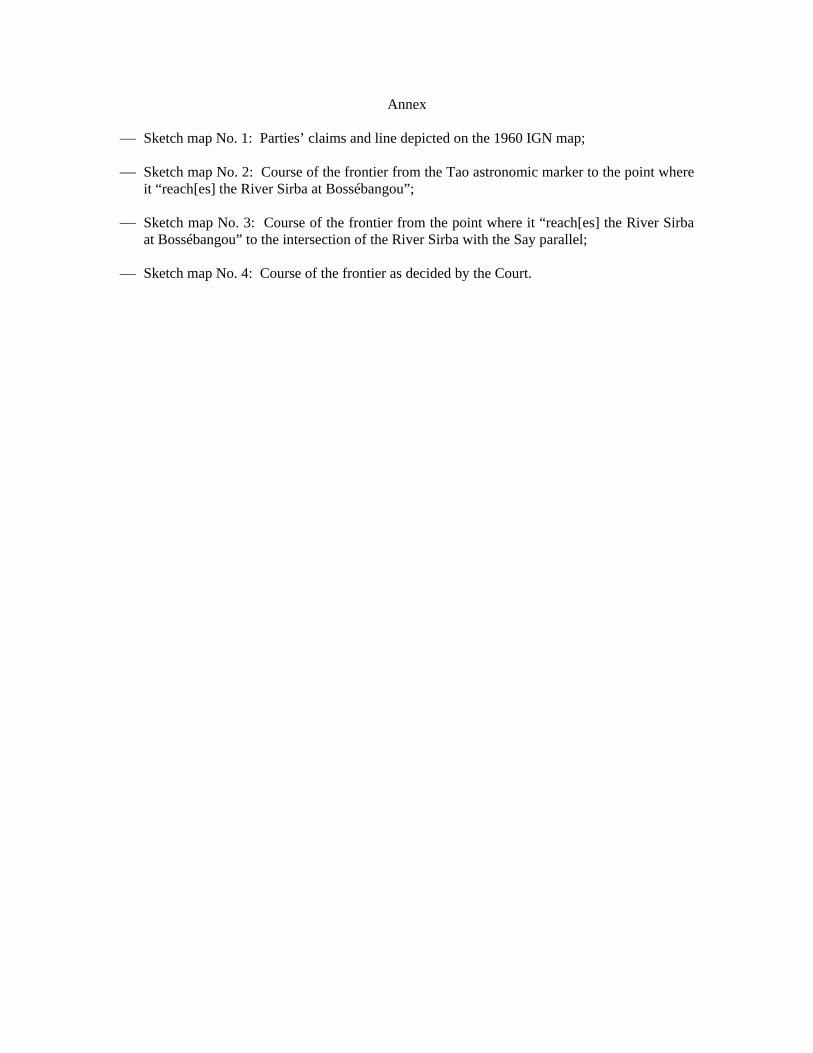
Annex
Sketch map No. 1: Parties’ claims and line depicted on the 1960 IGN map;
Sketch map No. 2: Course of the frontier from the Tao astronomic marker to the point where it “reach[es] the River Sirba at Bossébangou”;
Sketch map No. 3: Course of the frontier from the point where it “reach[es] the River Sirba at Bossébangou” to the intersection of the River Sirba with the Say parallel;
Sketch map No. 4: Course of the frontier as decided by the Court.