Page 1
1971 GEOLOGICAL EXPLORATION
OF
PEACE RIVER CANYON COAL ‘PROPERTIES
NORTHEASTERN BRITISH COLUMBIA
G. A. CHECK and
L. B. HALFERDAHL, Ph.D., P. Eng.
December 30, 1971
L. 9. Halferdahl & Associates Ltd. 401 - 10049 Jasper Avenue
Edmonton 15, Alberta
Page 2
TABLE OF iONTENTS
Page -
Introduction .......................... 1
Summary and Recommendations ................... 2
Property. .......................... .4
Geographic Setting ......... ; ............. 5
Previous Investigations and Production .............. 6
Stratigraphy ......................... 7
Monteith and Beattie Peaks Formafions .......... 9
Brenot Formation ................... 10
Cadomin Formation ................... 10
Gething Formation ................... 11
Moosebar Formation .................. 12
Gates, Hasler, Goodrich, Cruiser Formations ....... I 13
Structure . . . . ‘. . . . . . . . . . . . . . . . . . . . . . . ”
14
King Gething Mine Area . . . . . . . . . . . . . . . . . . . .’ 16 .
Southern Part of Mount Johnson . . . . . . . . . . . . . . . . 19
Coal Seams ......................
Correlation of Coal Seams ...................
21
21
Transportation ........................ 32
‘Conclusions .......................... 33
References ........................... 35
Certificate ............. : ............. 37
Page 3
Page
Appendix 1: Type Section of Moosebar Formation,
Contact Point, Peace River Canyon . . . . . . . . . Al .
Appendix 2: Driller2 Reports for 1969 Drill Holes
along Road to Gething Mine . . . . . . . . . . . .
e Appendix 3: Coal Analyses from Seams Sampled by
Drilling in December 1969 . . . . . . . . . . . .
&Appendix 4: Qther Analyses of Coal from Seams at
the Peace River Canyon . . . . . . . . . . . . . .
Appendix 5: Descriptions of Coal Seams at the
Peace River Canyon . . . . . . . . . . . . . . . .
A3
A8
A10
Al4
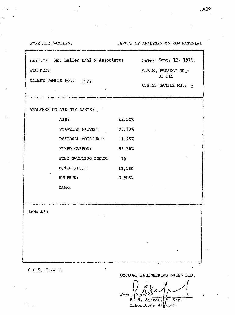
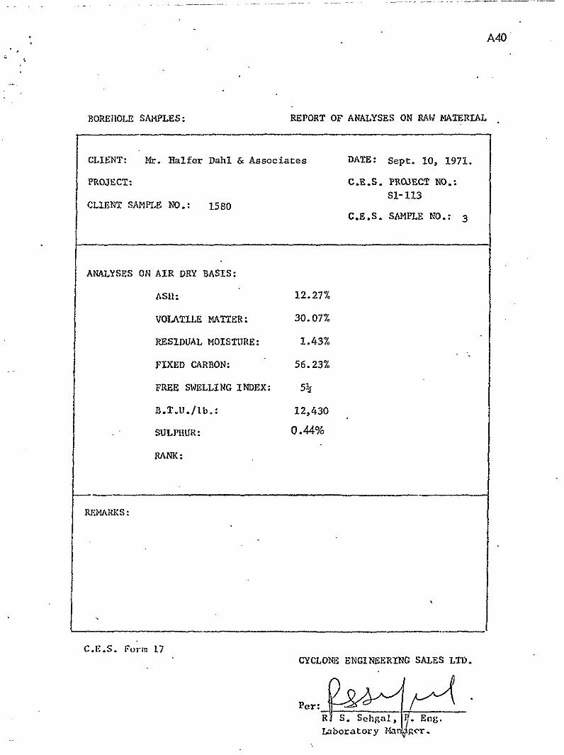
.qAppendix 6: 7971 Analyses of Coal Samples ............ A33
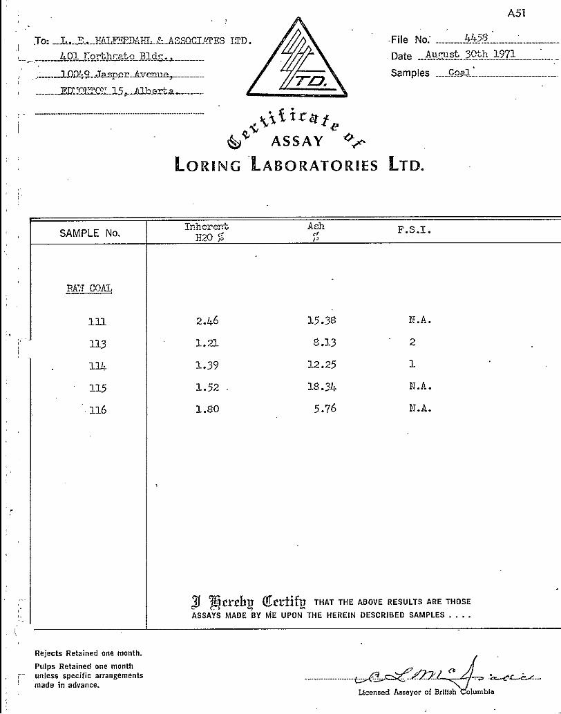
# Appendix 7: Reports of Coal Analyses ............... .A38
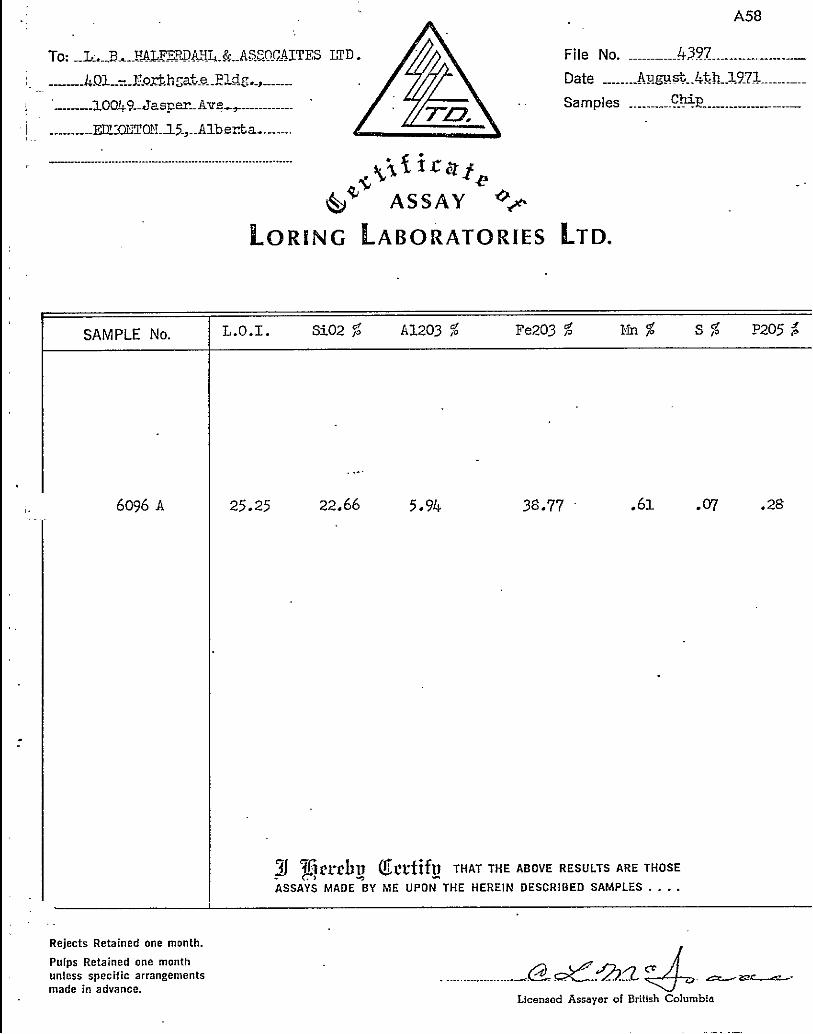
.B Appendix 8: Ironstone Concretions ................ A57
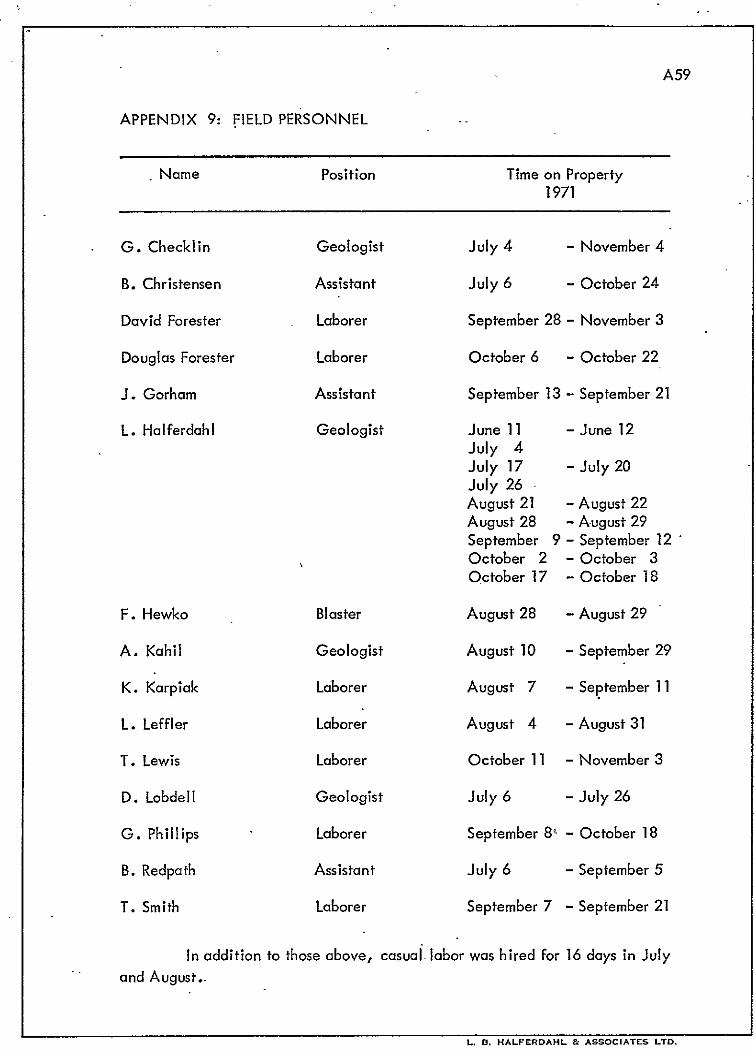
Appendix 9: Field Personnel .................. A59
.LIST OF ILLUSTRATIONS
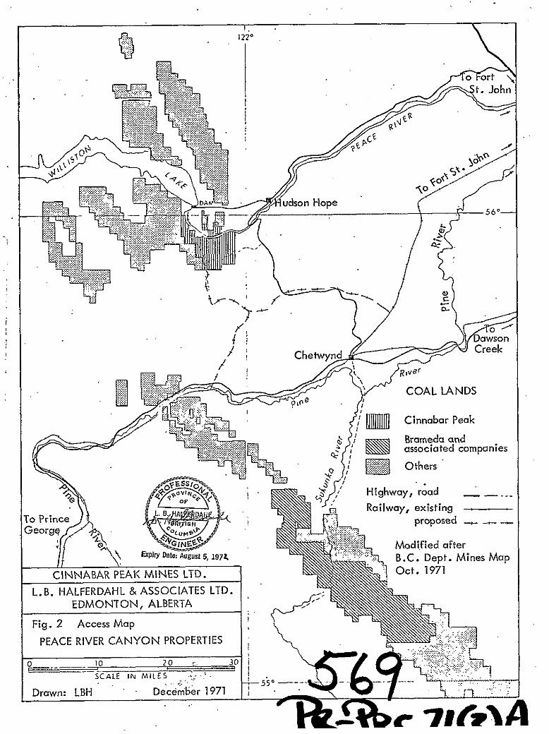
Figure 1. Location Map .................... At End
Figure 2. Access Map .................... At End
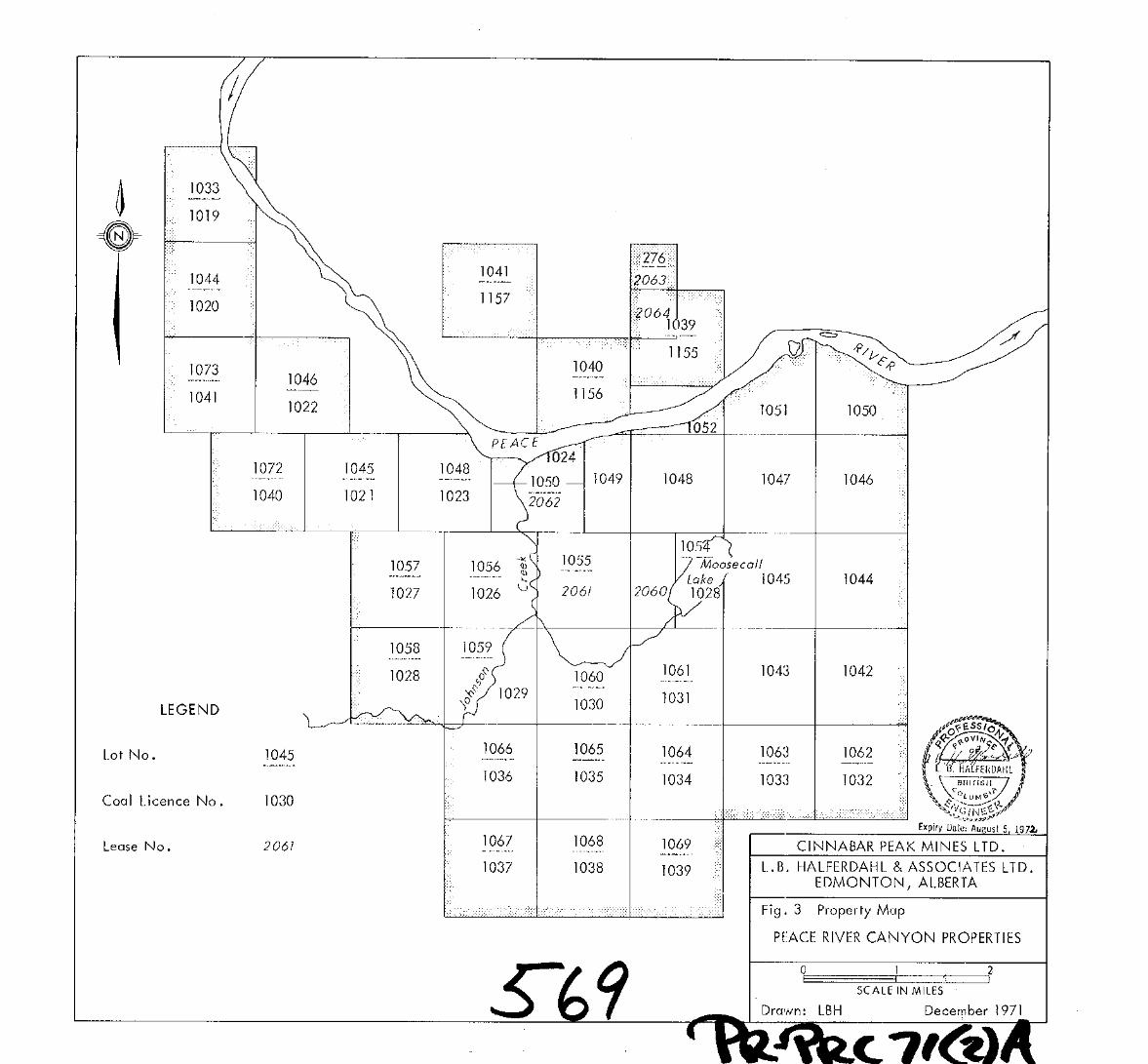
Figure 3. Property Map .................... At End
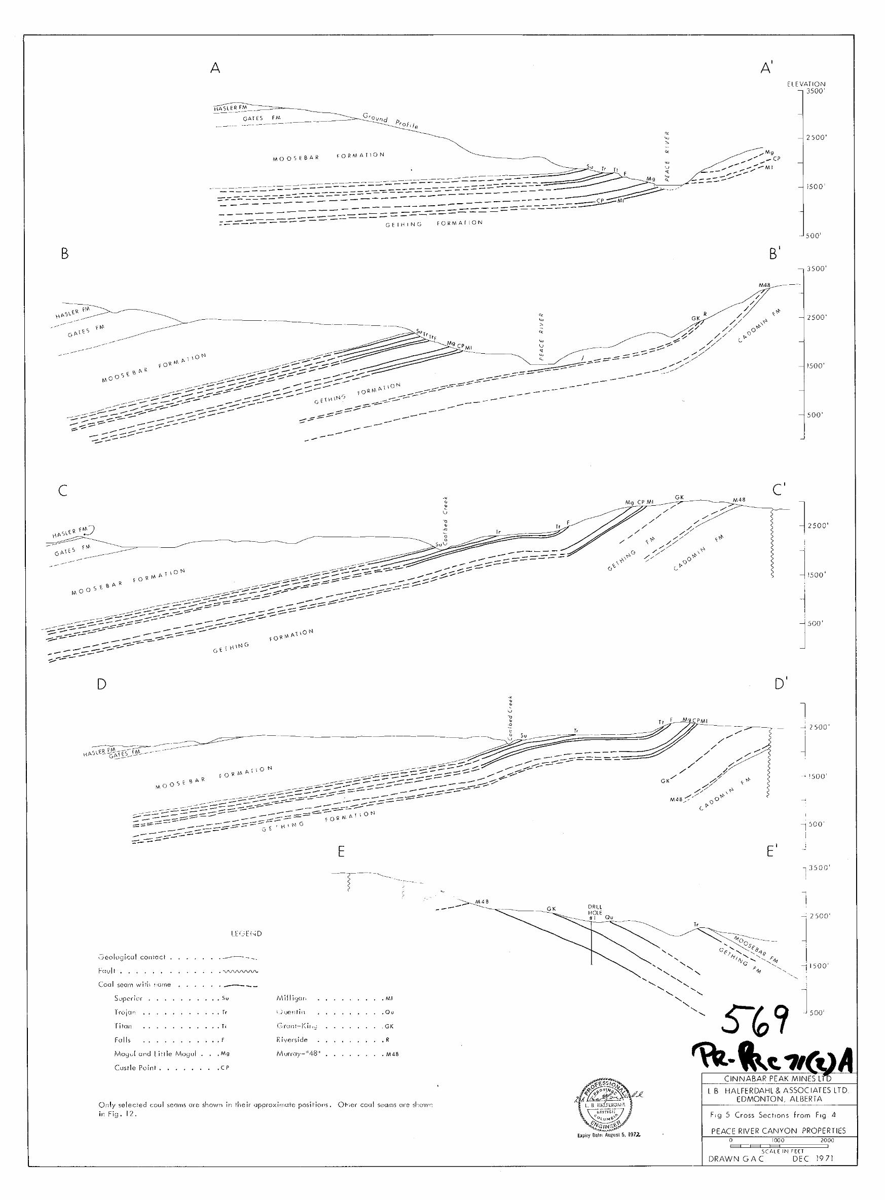
Figure 4. Geology and‘coal Seams ............... In Pocket
Figure 5. Cross Sections from Fig. 4 ............. In Pocket
Figure 6. King Gething Mine Area . . . . . . . . . ; . . . . . In Pockef
iigure 7; 1969 Drill Holes along Road to Gething Mine . . . . . . At End
Figure 8. Coal Seams on South Slope of Mount Johnson . . . . . . In Pocket
Figure 9. Coal Seams on South Slope of Mount Johnson - Section A-A’ of Fig. 8 . . . . ., : . . _. ‘. . . . . . At End
.‘y:, ~ -1. ‘f’
0 &F&cc? To: PR- &a,:~ Ey,&f’r ~c;~Y~L”:~~ -new
:. :: -:.:,, corJFlw~w=tL A:?kLqTz F&G
. -*il
_ ___- ^ _____. .___ _^
Page 4
Figure 10. Columnar Section in Trench #2 Mount Johnson . . . . .
Figure 11. Coal Seams on East Flank of Mount Johnson . . . . . .
Figure 12. Correlation of Coal Seams . .’ , . . . . . . . . . . .
LIST OF TABLES
Table 1:
Table 2:
Table 3:
B Table 4:
Table 5:
Coal Mines and Production . . . . . . . . . . . . .
Lower Cretaceous Formations at the
Peace River canyon . . . . . . . . . .~. . . . , . . . .
Thicker Coal Seams in the Gething Formation . . . .
Analyses of Coql from Trojan Seam after Blasting . . .
Preliminary Estimates of Coal Reserves on Peace
River Canyon Properties of Cinnabar Peak Mines Ltd.
Page
At End
At End
In Pocket
7
8’
22
27
30
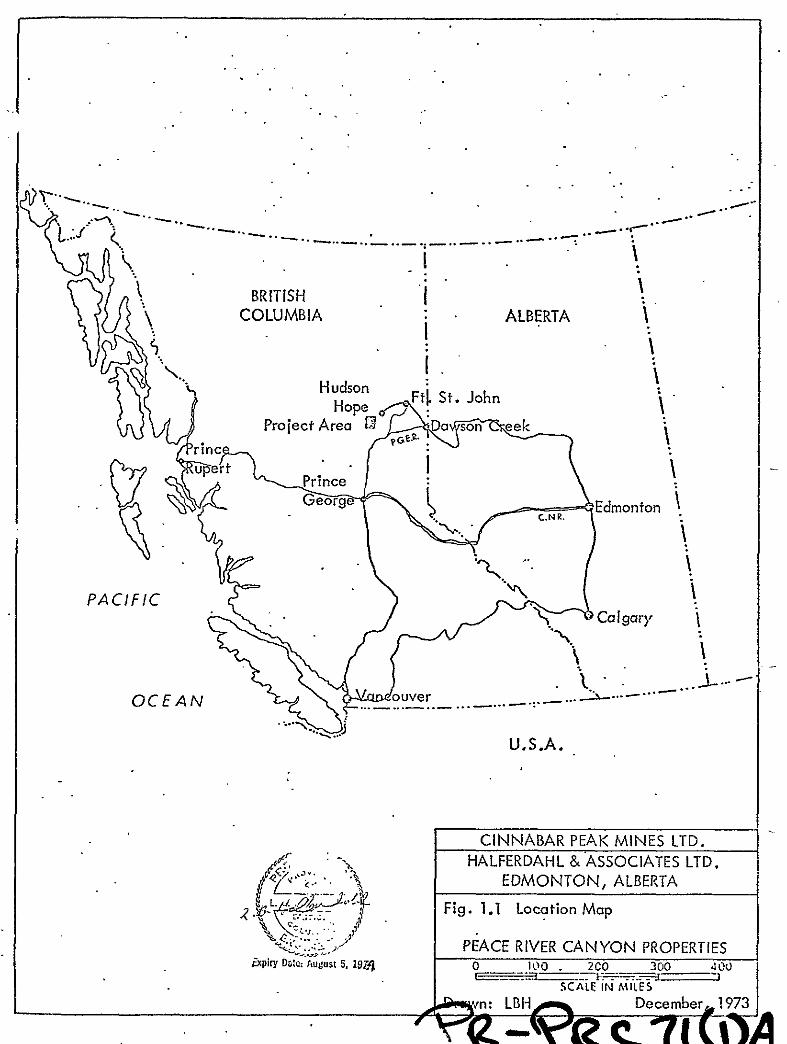
Page 5
COLUMBIA
.._.. -_..-... _,..__.. &...a-...--“’
U.S.A.
CINNABAR PEAK MINES LTD.
L.B. HALFERDAHL & ASSOCIATES LTD. EDMONTON, ALBERTA
Fig. 1: Location Map
PEACE RIVER CANYON PROPERTIES
fiP’” Date: August 5, ,97L 0 100 2co --I
300 400
SCALE I, MILES 1
- Drawn: LBH December 1971
r
Page 6
INTRPDUCTION
Numerous coal seams in the Lower Cretaceous Gething Formation ’
have been known in the Peace River Canyon of northeastern British Columbia
since before the turn of the century. Although their stratigraphy has been
investigated in considerable detail from time to time by government geologists,
and small amounts were mined each year for more than 20 years, mostly for
‘I ocal heating purposes, it is the worldwide interest in coal, particuarly
coking coal, in the past few years, that has provided the exploration incentives
to obtain the geological and engineering information needed to decide whether.
large scale mining of these coal seams is economic.
Cinnabar Peak Mines Ltd. obtained coal rights in and near the Peace
River Canyon in 1969 and 1970, and drilled three holes in late 1969.
In 1971 geological field work on the coal properties held by
Cinnabar Peak Mines Ltd. began on July 4 and ended on November 4, with
a crew ranging from 4 to 7 men. The work included locating, measuring, and
sampling coal seams throughout the properties, geological observations on
formations adjacent to the coal-bearing Gething Formation, cutting of trails
and baselines, trenching of seams by both bulldozer and blasting, and
constructing access roads to isolated areas as well as to potential drill sites.
Accommodation for the crew was rented in Hudson Hope, about 20 miles by
road from the properties. Transportation was provided by rented vehicles:
one 4x4 and a j-ton pickup. A canoe was used to cross the Peace River to
provide access to the south side of the Canyon. Two bulldozers, a D6 and
a D8, were contracted for trenching and construction of access roads.
This report provides geological data from the first stage of the
program designed to evaluate the coal seams on the Peace River Canyon
properties of Cinnabar Peak Mines Ltd. It is based on available data in
published and unpublished reports, on the 1969 drilling, and on the exploration
undertaken in 1971. The section on Stratigraphy is based mostly on published
Page 7
‘2.
reports, and is longer than the usual brief summary because the previous.
stratigraphers who have studied the Peace River Canyon do not yet appear
to agree on an entirely satisfactory sequence of formations. Throughout
this report, all thicknesses of coal seams are in inches.
SUMMARY AND RECOMMENDATIONS
The property consists of 37 coal licences comprising 21,755 acres
and options on 5 leases comprising 1600 acres. These are located on both
sides of the Peace River Canyon in northeastern British Columbia, a few
miles downstream from the Bennett Dam, and from 10 to 20 miles southwest
of Hudson Hope. Access to the properties is by highway, logging roads,
and other unimproved roads. They are about equally distant from Roberts
Bank near Vancouver and Prince Rupert: less than 700 miles. A spur line
40 to 50 miles long will connect them to an existing railway.
The coal seams have received considerable attention from government
geologists, but production from 5 mines in or adjacent to the property t&lied
less than 60,000 tons until 1963 when all production ceased due to depressed
markets for coal.
The rocks in and near the Peace River Canyon consist of Lower
Cretaceous sandstones, shales, mudstones, ironstone, conglomerates, and
coal seams in the Minnes, Bullhead, and Fort St. John Groups. The Gething
Formation contains the coal seams that are of interest. The area can be
divided into three bands on the basis of geological structures: a western band
with apparently uniform dips mostly less than 20’ to the west and southwest
and decreasing to the southwest, a central disturbed band with folds and faults,
and an eastern band with mostly uniform dips up to 30’ to the east.
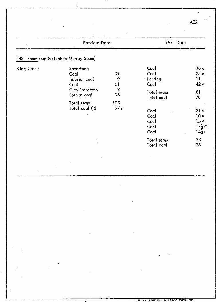
Three of the formerly operated mines in the area produced coal from
the King and “481’ Seams which were intersected down the dip in two of the
holes drilled in 1969.
Page 8
‘3.
Included in more than 35 coal seams, apparently in the middlepart
of the Gethlng Formation and uncovered by bulldozer trenching on Mount
Johnson, are four seams with thicknesses ranging from 28 to 60 inches. On
and near the southern part of Mount Johnson, these and other seams are at
or close to dip slopes, which may make them suitable for strip mining.
Twenty coal seams with average thicknesses ranging from 22 to 84
inches have been correlated, some definitely, others less definitely, for as
much as 11 miles along their strikes mostly on the properties of Cinnabar Peak
Mines Ltd. They underlie much of the properties. Two of these seams have
free swelling indexes in the range of coking coals; others may also be of
coking or blending quality6 Most of the coal is low ta medium volatile
bituminous with low ash, and almost all with less than one per cent sulfur,
making it suitable for coal-burning power plants.
Preliminary rese;ve estimates are 402,233,OOO tons indicated and
687,824,OOO tons inferred. Of these there are 244,738,OOO tons indicated
and 464,206,OOO tons inferred in seams with average thicknesses greater than
45 inches. Included in these estimates are 251,461,OOO tons of potentially’
coking coal in two seams near the top of the Gething Formation. Most of the
coal in the thicker seams appears suitable for underground mining; as much as
20,000,OOO tons may be suitable for strip mining.
It is recommended that additional geological and engineering infor-
mation on the coal seams in the Peace River Canyon properties of Cinnabar
Peak Mines Ltd. be obtained. Initially holes should be drilled at the four or
five sites prepared during the 1971 program. Additional drilling and sampling
by the driving of adits are subsequent requirements.
.
Page 9
4.
PROPERTY
The coal properties near the Peace River Canyon (Fig. 3) held by .
Cinnabar Peak Mines Ltd. consist of 37 coal licences comprising 21,755 acres
and options on 5 leases comprising 1,600 acres, which cover rights for all coal,
petroleum, and natural gas. Details are given below. All the coal licences
were issued November 27, 1970, and rentals and renewals have been paid to
November 27, 1972.
,Cdal Licence No. Lot No.
1019
1020-2
1023
1024
1025
1026-39
1040-l
.1033
1044-6
1048
Part N& 1050 south of Peace River
E& 1054
1056-69
1072-3
1042-S Unsurveyed (1 sq. mile each)
1049 Unsurveyed (4 sq. mile)
1050-2 Part of unsurveyed lots south of Peace River
1155 S$ and NE& 1039
1156 Part 1040 north of Peace River
1157 1041
Lease No. Lot No.
2060 w; 1054
2061 1055
2062 s+! 1050
2063 276
2064 NW; 1039
.
Page 10
5.
GEOGRAPHIC SETTING
The properties are in northeastern British Columbia, 10 to 20 .
miles southwesterly from the Town of Hudson Hope. The licences and leases
are on both sides of the Peace River Canyon, a few miles downstream from the
W.A.C. Bennett Dam of the British Columbia Hydro and Power Authority near
Portage Mountain.
Hudson Hope has a population of about 2000 and is about 45 miles
southwesterly from Fort St. John to which it is connected by a paved road
about 60 miles long. Hudson Hope is about 25 miles northwesterly from
Chetwynd to which it is connected by a paved highway about 40 miles long.
Both Fort St. John and Chetwynd are on paved highways forming part of the
British Columbia highway net and both are on the Pacific Great Eastern
Railway which comes to within 18 or 20 miles of the property. Fort St. John
is served by regularly scheduled airline flights from Edmonton and Vancouver.
From Hudson Hope parts of the property on the north side of the
Peace River are reached via the paved road to the Bennett Dam for about 5
miles and thence southwesterly on an unimproved road passable for a late
model car in wet weather for about another 5 miles. Other parts are accessible
from access roads built in connection with the construction of the Bennett Dam.
From Hudson Hope the property on the south side of the Peace River is reached
via the highway to Chetwynd for 11 miles and thence westerly for about
8 miles on a well maintained gravel logging road constructed by Canadian
Forest Products, but open to the public. This road continues west across the
property and connecting roads cross other parts of the property.
The property is crossed by electric power lines from the Bennett Dam
and by a natural gas pipe line.
The Canyon of the Peace River which crosses the property is about
1000 feet deep. The summit of Portage Mountain which is almost on the property
on the north side of the Peace River rises 3000 feet above the bottom of the
Page 11
Canyon. Mount Johnson on the south side of the Peace River rises about 4600
feet above the bottom of the Canyon. Except for these topographic features and
the valleys of creeks tributary to the Peace River, the rest of the property has
only moderate slopes. Much of the property was burned many years ago and is
now covered with second growth stands of poplar, pine, and spruce. Some has
been logged. Except for the Peace River Canyon and the canyons and beds of
tributary streams, outcrops are scarce although some bedrock is exposed at depths
of only a few feet at places along the Canadian Forest Products logging road.
PREVIOUS INVESTIGATIONS AND PRODUCTION
The coal seams and stratigraphy in the Peace River Canyon have been
investigated many times by government and other geologists. The most detailed
study of the coal seams is that of F.H. McLearn in 1922. Additional details
were obtained by McLearn and Irish (1944, by Beach and Spivak (1944), by
the British Columbia Hydro and Power Authority in their damsite investigations
in the late 1950’s and early 1960 ‘s, and by Stott (1968) and (1969). Some of
the Annual Reports of the British Columbia Minister of Mines not listed in the
references contain information on mining, production, and inspections.
Complete data on coal mining and production have not been obtained,
but some information is summarized in Table 1. During the periods of production,
high transportation costs and latterly competing fuels restricted most consumption
of coal from these mines to heating for local use and along parts of the Alaska
Highway.
Page 12
7.
TABLE 1: COAL MINES AND PRODUCTION
Dates Mine Location Seam Workings Production (tons)
About 1923 Aylard
1928
1940-48 Gething
No. l&2
1944-51 Peace
River
Larry
Creek
1949-63 Gething King
No. 3 Creek
Grant Grant
Flat
Coalbed Trojan
Creek
King King
Creek
Modest
Adit 35’
Drift 65’
Extensive
65 in 1923
1,000 (est. total)
Not recorded
4,000 (est .)
Murray Extensive . 22,000 (est.)
“48” Extensive 28,000 (est .)
STRATIGRAPHY
The exposed bedrock in and near the Peace River Canyon consists mostly
of Lower Cretaceous Formations. One of these - the Dunlevy - much used in
previous geological investigations of the area for Lower Cretaceous rocks strati-
graphically below the Gething Formation, is now known to comprise strata which
cannot be properly grouped into one formation according to stratigraphic
principles. Its abandonment has been recommended by Hughes (1964) and by
Stott (1967),(1968). Additional background information on the use and misuse
of the Dunlevy Formation is given in some of the references.
As no new stratigraphic data on this part of the stratigraphic section
were obtained during the 1971 field work, the stratigraphic names, intervals,
and units used throughout this report (Table 2) are mostly those designated by
Stott (1967) with some modificdtions to bring them closer to the views of Hughes
(1964). The Cadomin Formation is used in spite of its long range correlations
.
Page 13
8.
TABLE 2: LOWER CRETACEOUS FORMATIONS AT THE PEACE RIVER CANYON
Group Formation Lithology Thickness
Fort St. John Cruiser Marine shale and thin sandstone 800’ to
900’
Goodrich
Hasler
Marine sandstone with interbedded
shale
Marine shale with thin sandstone
beds
up to
1320’
700’ to
868’
Gates Massive sandstone with interbedded
mudstone
227’ to
430’
Dark marine mudstone, thin
Moosebar ironstone
958’ to.
1085’
Bullhead Gething Non-marine sandstone and shale;
coal seams
1650’ to
1850’
Cadomin Non-marine conglomerate,
sandstone, shale, thin coal seams
343’ to
556’
Minnes Brenot Non-marine sandstone, shale
thin coal seams
485’
Beattie Marine sandstone, siltstone, 331’
.Peaks shale, and ironstone
Monteith Marine sandstone, quartzites, 583’ to
thin shale 1200’
Page 14
9.
with the type section of the Cadomin, and the difficulty in distinguishing it from
some of the coarser sandstones of the Gething Formation. This difficulty may well
account for its reported large change in thickness in and near the Peace River
Canyon. The lower contact of the Gething Formation is placed where the
fine-grained sandstones of the Gething become coarse-grained and conglom-
meratic; this is the sctme stratigraphic horizon used by Stott and most other
investigators. In spite of Stott, it seems reasonable to correlate Hughes’
Brenot Formation with its thin coal seams with Stott’s unnamed unit at the top
of the Minnes Group below the major pre-Cadomin unconformity. The Beattie
Peaks Formation corresponds only to unit 1 of Stott (1967). If this is correct
then the chief differences between Stott and Hughes seem to be the recognition
or lack of recognition of unconformities above and below the Brenot Formation
and their relative importance. Possibly there are two unconformities.
Monteith and Beattie Peaks Formations
In and near the Peace River Canyon, the Monteith Formation has been
mapped by Hughes (1964) on Grant Knob. Although not mapped as such,it.probably
forms part of the undifferentiated pre-Gething strata on Mount Johnson on the
south side of the Peace River. On Grant Knob, Hughes measured 583 feet in
the upper part, and in a well about 10 miles north of Grant Knob, noted 960
feet for the whole Monteith Formation. Interpolation between known thicknesses
on Beattie Peaks to the southwest and in a well 15 miles east indicates
a thickness of about 1200 feet at the Peace River Canyon. The Monteith
Formation is marine and consists dominantly of sandstones and quortzites with
less thin shale. The sandstones can be grouped into quartzites and quartzitic
sandstones, some with abundant granule size material, and argillaceous and
feldspathic sandstones. Bitumen has been found in many of the sandstones in
varying amounts.
The Beattie Peaks Formation has also been mapped by Hughes (1964)
on Grant Knob, and probably forms part of the undifferentiated pre-Gething
strata on Mount Johnson on the south side of the.Peace River. On Grant Knob,
Page 15
10.
Hughes measured 331 feet of strata,which comprise the entire formation thdre:
it thickens to the west and thins to the east. The Monoch Formation (unit 2 of
Stott, 1967) which overlies the Beattie Peaks Formation to the west was not ’
found on Grant Knob. The Beattie Peaks Formation is marine and consists of
thick-bedded fine-to medium-grained sandstones, and thinly interbedded black,
dark grey, and brown shales and siltstones, thin sandstones, and ironstone bands.
Brenot Formation
Like the two preceding formations, the Brenot Formation has been
mapped by Hughes (1964) on Grant Knob and probably forms part of the
undifferentiated pre-Gething strata on Mount Johnson. On Grant Knob,
Hughes measured and estimated 485 feet of strata which comprise the entire
formation there. This compares with 359 feet described by Hughes in a well
about 10 miles north. According to Hughes, exposures of the Brenot Formaiion
consist mostly of sandstone, but some cyclothems with fine-grained sandstones,
silty, sandy, and carbonaceous mudstones, coals, black carbonaceous shales,
dark grey sandstones and shales, and siltstone and sandstone are present. The
coal seams noted by Hughes on Grant Knob are thin, the thickest being 4 inches.
However, at the Packwood (Reschke) Mine on the west side of Butler Ridge
about 14 miles northwesterly from Grant Knob, 2 or 3 seams ranging from 30
inches to 5 feet thick have been mined in strata which are probably equivalent
either to the Brenot Formation or to part of the Cadomin Formation.
Cadomin Formation
The Cadomin Formation in and near the Peace River Canyon is present
on the west sides of Mount Johnson, Grant Knob, and Portage Mountain. From
there it extends northwesterly to the W.A.C. Bennett Dam and beyond on the
southwest side of Wil I iston Lake. The apparent thickness varies in the Peace
River Canyon partly because of facies changes, and partly because the upper
contact has been placed at different stratigraphic levels in different places in the
Page 16
.._
.ll.
area. Stott (1968) measured 343 feet in part of the Cadomin Formation at the
head of the Peace River Canyon. The Cadomin‘forms the lower part of fiughes’
Dresser Formation; with the top of the Cadomin 41 feet below the Murray Coal .
Seam, the total thickness of the Cadomin Formation in the drill holes used by
Hughes at the head of the Peace River Canyon is 556 .feet. Exposures at the
head of the Peace River Canyon measured by Stott (1968) show that the Cadomin
consists mostly of medium-to coarse-grained sandstone and conglomeratic sand-
stone with pebbles to one or two inches in size. Beds of these rocks are up to
50 feet thick, and grade laterally into each other in short distances. Hughes’
descriptions of drill core show in addition to the sandstones a number of coal
seams up to 6 inches interbedded with shale in some intervals, and several
thick intervals consisting dominantly of shales and siltstones.
Gething Formation
Strata of the Gething Formation outcrop along most of the upper part
of the Peace River Canyon from the W.A.C. Bennett Dam to Grant Flats and
intermittently along creeks tributary to the Peace River in this area. At
Johnson Creek the outcrop belt of the Gething Formation leaves the Peace
River, extends along the west, south, and east sides of Mount Johnson, crosses
the Peace River and trends north along the east side of Portage Mountain.
Measurements and estimates of the thickness of the Gething Formation in the
Peace River Canyon ranging from 1000 feet to about 1800 feet have been made
by McLeorn (1923) and Stott (1968), (1969),. No one has yet measured one
complete section of the Gething Formation; the best available is that of Stott
(1969) who measured all but 150 feet to 190 feet, mostly inaccessible, at the
fop of the formation, downstream along the west bank of the Peace River
starting near the base of the W.A.C. Bennett Dam. In order to match coal
seams on both sides of the Peace River, Stott postulated a fault* a short distance
* If present, this fault was apparently missed by those’investigating sites for
the W.A.C. Bennett Dam (Dolmage and Campbell, 1963).
Page 17
12.
upstream from Gething Creek. With this fault, the stratigraphic interval
measured constitutes the lower 1460 feet of the Gething Formation up to the
top of the Titan Coal Seam. With 190 feet in the Gething Formation above
the Titan Seam in the Aylard Creek section, the total thickness of the Gething
is 1650 feet in the upper Peace River Canyon. In a well 15 miles east, Stott
(1968) assigned a thickness of 843 feet to the Gething Formation. This
variation and possibly others in the lower Peace .River Canyon are due to
facies changes or to the fact that the Gething-Cadomin contact is not at the
same horizon at different places.
The upper contact of the Gething Formation in the Peace River
Canyon is marked by a bed of conglomerate one-half to one foot thick which
contains pebbles of chert to one or two inches in size. This conglomerate was
located in 1971 at Aylard Creek, Coalbed Creek, and at Contact Point. At
Contact Point underlying the conglomerate is a unit of dark brownish-grey
fine-grained sandstone and silty sandstone containing nodules of pyrite or
marcasite.
The Gething Formation in and near the Peace River Canyon consists
mostly of fine-grained sandstones, siltstones, mudstones, and shales of grey,
brown, or black; and bands and concretions of clay ironstone, and orange to
buff-weathering dolomitic rocks. The sandstone units range up to 30 feet or
more, and are commonly thinly bedded. Units of siltstone, mudstone, a’nd
shales range up to 20 or 30 feet or more, but are mostly less. Numerous coal
‘seams ranging up to 8 feet thick with many averaging more than 40 inches are
present throughout the Gething Formation. They are described in later sections
of this report.
Moosebar Formation
Southwest of the upper and middle parts of the Peace River Canyon,
the Moosebar Formation forms a southeasterly trending band where it is exposed
above the Gething Formation along parts of some creeks. South of Mount
Johnson, the Moosebar swings to the east and then trends northerly past
Page 18
13.
Moosecall Lake and crosses the Peace River at Contact Point. Stott (1963)
moved McLearn’s type section from the north to the south side of the
Peace River at Contact Point where he measured its thickness as 958 feet. ’
Thicknesses greater than 1300 feet have been measured on Track Creek
(a tributary of Gething Creek) (St&t, 1968; Beach and Spivak, 1944) but
Stott indicates that there the Moosebar Formation has been thickened by
faulting. As the Moosebar-Gething contact forms an excellent horizon
marker, the thickness of the Moosebar Formation can be used in covered
areas of the property to plot the Moosebar-Gething contact from the
Moosebar-Gates contact. Accordingly, in September 1971, A. Kahil
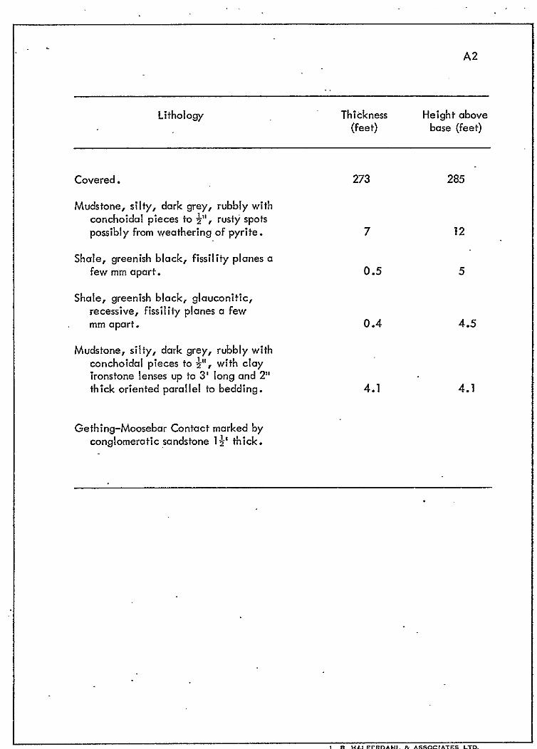
measured the Moosebar type section at Contact Point (Appendix 1). He
obtained a thickness of 1085 feet. A compromise thickness of 1000 feet
has been used in this report for the Moosebar from Contact Point to Coalbed
Creek, thence increasing to 1350 feet northwesterly to Gething Creek.
The Moosebar Formation consists of a monotonous succession of
recessive, rubbly, marine mudstones with a few sandstone intervals up to
3 or 4 feet thick near the top. A few layers are glouconitic. Clay ironstone
concretions up to 6 inches or more are common throughout; they are mostly
in layers and in places are the only means of determining the attitudes of the
rubbly mudstone in which bedding is not distinct. The apparent lack of
visible bedding may account for part of, the variations in measurements of the
thickness.
Gates, Hasler, Goodrich; and Cruiser Formations
The Gates, Hasler, and Goodrich Formations overlie the Moosebar
Formation on the south side ‘of the Peace River Canyon where their outcrop
belts form an irregular U open to the north, with the Gates and Hosler trending
north across the Peace River east of Portage Mountain. The Cruiser Formation
outcrops only on the flank of Tworidge Mountain in the extreme southeast
corner of the property. Near Steamboat Island in the Canyon, the Gates
Formation is 227 feet thick and consists of two sandsto’ne units separated by
1. B. HALFERDAHI & **50CIATEs LTD.
Page 19
14.
silty mudstones-(St&t, 1968). At the same locality, Beach and Spivak (1944)
measured 245 feet of the Gates Formation, and on Johnson Creek 430 feet.
At the mouth of Starfish Creek in the lower part of the Canyon, the
Hasler Formation consists of 700 f&et of dark grey, thin-bedded marine shales
with thin sandstone layers (Beach and Spivak, 1944). This compares with 868
feet in the type section about 20 miles to the south (Stott, 1968).
A complete section of the Goodrich Formation has not been measured
near the Peace River Canyon. ‘It consists mostly of sandstones and is 1320 feet
thick about 20 miles to the south (Stott, 1968).
The Cruiser Formation consists mostly of recessive shales; nowhere has
a complete section been measured. Beach and Spivak (1944) estimated a total
thickness of 800 to 900 feet on Tworidge Mountain near the extreme southeast
corner of the property.
STRUCTURE
The part of the Peace River Canyon which includes the properties of
Cinnabar Peak Mines Ltd. can be divided into three northerly trending bands
on the basis of geological structures. The central band is the most disturbed.
It is about 14 miles wide, and crosses Portage Mountain, Grant Knob, and
part 9f Mount Johnson. In 1971 field observations were made only on the
southern part of Mount Johnson and on the east side of Portage Mountain.
Therefore, the basis for the structural interpretation herein includes observations
from Beach and Spivak (1944) and aerial photographs. The western border of
the central structural band is gradational with westerly dips steepening from
20° or less to as much as 50° or 60°. Farther east the dips decrease toward
the axis of the southerly extension of the Butler anticline. North of the Peace
River the Butler anticline appears well established from dip and strike
measurements. Its axis apparently is intersected by a well.established high-
angle fault on the east, but the location of this intersection is uncertain. One
attitude indicates that the axis of the Butler anticline extends south of the Peace
Page 20
i5.
River, but aerial photographs indicate uniform westerly dips west of the fault
south of the Peace River. East of the high-angle fault north of the Peace River
is a band about 1000 feet wide mapped as Gething Formation at the axis of a
syncline by Beach and Spivak. Aerial photographs indicate a band of steeply
dipping rocks with a structural discontinuity with more gently dipping strata on
the east. The east boundary of these steeply dipping rocks is shown as a fault.
Farther east on the east side of Portage Mountain the contact between the
Cadomin and Gething Formations is shown as faulted in agreement with Beach
and Spivak. The extent of the two easterly faults across to the south side of
the Peace River is not known. Near the King Gething Mine, measured attitudes
by McLearn and Irish (1944) indicate an anticlinal axis in the Gething Formation
a few hundred feet east of the most easterly-fault.
South of the Peace River on the southeast side of Mount Johnson the
most westerly fault is well established by a linear topographic depression,
changes in attitude of the beds as it is crossed, and a linear feature on aerial
photographs. This fault appears to extend for at least several miles to the
south, but it has not been precisely located. Changes in attitude of strata in
the Gates Formation one to two miles south of Moosecall Lake may be related
to it. East of the fault is what appears on aerial photographs to be a southerly
plunging anticline, and then a syncline. These are confirmed by measured
attitudes of beds. Farther to the east is a prominent northerly trending scarp
which may be an extension of a fault from north of the Peace River. In this
area, measurements were obtained in two places on southeasterly dipping
strata. These may indicate an anticlinal axis near the scarp, but data are
insufficient to choose between these two possibilities.
One or possibly more subsidiary faults from the major structures in the
central structural band are shown. Others can be expected.
The western structural band is three to four miles wide, and comprises
rocks of the Gething, Moosebar, Gates, and Hasler Formations. All strata
strike northwesterly and dip southwesterly, mostly at less than 16O, but a few at
20° and even 2.5’ where measured in and near the Canyon. However, on the
.
L. n. H*LFERD*“L ec *5soC1*iES LTD.
Page 21
16.
southwest side of the Canyon between Island and Johnson Creeks, the distance
between the upper and lower contacts of the Moosebar Formation and its
thickness requires an average dip of less than 109 and in places as low as 3O 01:
4”. These dips are confirmed by measurements of Beach and Spivak along and
near Johnson Creek in the Hasler Formation. Where rocks of the Gething
Formation are visible on both sides of the upper Canyon, their attitudes appear
regular and uniform. At the site of the W .A .C. Bennett Dam no faults of any
type were observed in the rocks (Dolmage and Campbel I, 1963). Farther down-
stream, Stott (1968) and (1969) accounted for thicker than normal sections of
the Gething and Moosebar Formations by postulating faults.
The eastern structural band is up to about three miles wide on the
properties of Cinnabar Peak Mines Ltd. North of the Peace River, strata of
the Gething Formation strike northerly and dip from 15’ to 30’ east. South
of the Peace River the strike is also northerly, but most of the dips are in the
range of 5’ to 20° east. Overburden and Moosecall Lake obscure the structure
of most of the Gething and Moosebar Formations south of the Peace River away
from the Canyon.
KING GETHING MINE AREA
The King Gething No; 1, 2, and 3 Mines are in Lots 276 and 1039
on the east slope of Portage Mountain. They are connected to the paved road
from Hudson Hope to the W.A.C. Bennett Dam by a narrow unimproved road,
but readily passable for an ordinary car even in wet weather. Almost all the
area is covered with scrub poplar and other bushes. Overburden obscures the
bedrock nearly everywhere except along creeks, but is only a few feet thick
in places.
The King Gething Mines are in strata of the Gething Formation which
consist of sandstone, siltstone, shale, mudstone, ironstone, and coal. As
explained in the section on Structure, the area of the mines is on the eastern
Page 22
17.
flank of an antiqline whose axis trends northerly. Most of the western flank is
cut or obscured by what appears to be a thrust fault. In the mine area, the dips
on the eastern flank range from 15O to 30°.
The King Gething No. 1 Mine was operated in the King Seam from
1940 to 1947 by driving a main entry which finally totalled 540 feet, a counter;
and working rooms to the rise. Within 50 to 125 feet of the main entry, the
rooms encountered glacial drift, and farther along the entry a burnt-out part of
the seam. At 540 feet in the main entry a fault cut off the seam, and water
flowing from it forced suspension of mining. Later, pil lam were extracted.
The mine is no longer accessible.
The King Gething No. 2 Mine was operated from 1947 to the spring of
1949. Entry was by means of a crosscut driven on the south side of King Creek
to intersect the southerly extension of the.King Seam which had been mined in
the No. 1 Mine. Production ceased when a layer of clay ironstone within the
seam made costs too high to continue operations. No data on the No. 2 Mine
workings are available; they are no longer accessible.
The King Gething No. 3 Mine was operated from 1949 to 1963 with
the last shipments made in early 1964. The No. 3 Mine.is in a seam designated
as the “48” Seam, about 3300 feet south of the No. 1 and No. 2 Mines. It was
developed by a main entry which was driven almost due north along the strike of
the seam and which finally totalled about 850 feet. A counter level was driven
initially 75 feet and later increased to 100 feet up the rise from the main entry.
It finally totalled 700 feet. Raises and rooms at intervals of 50 to 70 feet have
been driven to the rise from the main entry past the counter; two reached the
surface to provide ventilation and additional exits. In 1953 and 1954 strip
mining was attempted down.the dip of the “48” Seam from the main entry.
Overburden-ranging from 4 to 30 feet, including 8 to 14 feet of sandstone
which roofed the coal and required blasting, made the operation unsuccessful.
In 1954 some of the equipment was used to open a third entry for 120 feet,
100 feet on the slope from the main level. Palling markets for coal stopped
production in 1963. Access to much of the main entry is still easy although
Page 23
18.
large slabs of sandstone have caved from the back in places in the first 300
or 400 feet. One of the raises extending about 300 feet to the surface from
a point in the main entry is in very good condition. Methane has not been a
problem in any of the three mines.
Other seams in addition to the King and the “48” Seams are the
Quentin (32”) and Gully (3.5”) Seams and a few other thinner seams, which
were located or named or both by McLearn and Irish (1944). In 1971, a
30-inch seam and other thinner seams were located on the road to the Peace
River about 3000 feet south of the King Gething No. 3 Mine. Also in 1971,
a coal seam with 584 inches of coal was found along King Creek near where
the Gully Seam was reported. This thicker seam has been correlated with the
Trojan Seam on the basis of its stratigraphic position in the Gething Formation.
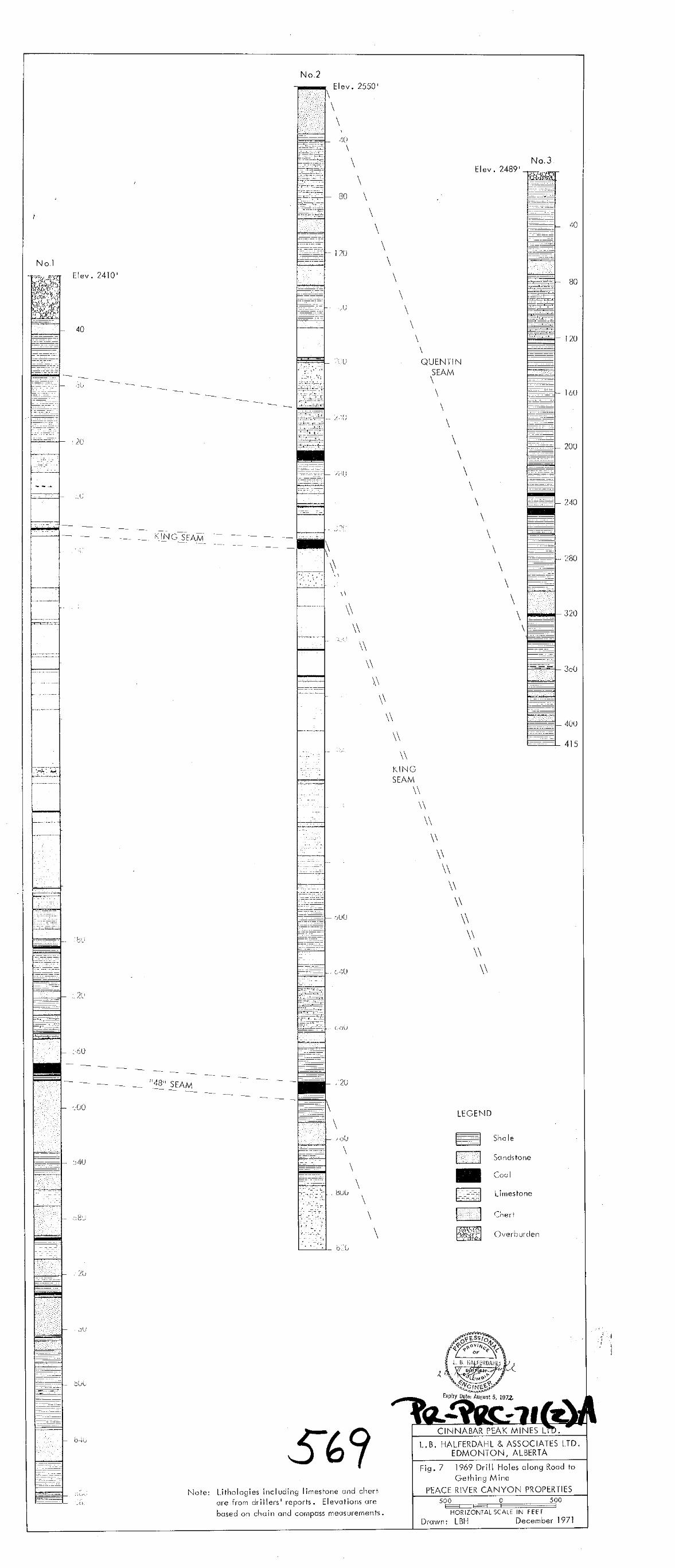
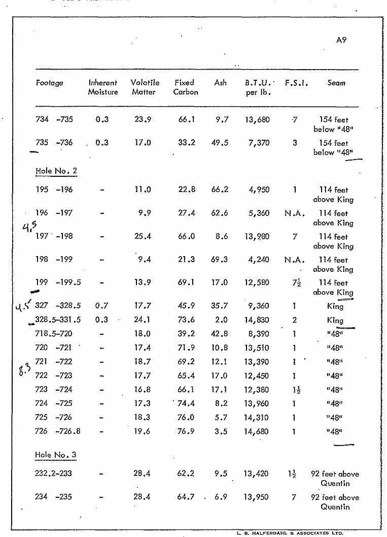
In late 1969, three holes drilled within 2000 feet east of the King
Gething No. 1 and No. 3 Mines (Fig. 6) intersected a number of coal seams
(Fig. 7). The drillers’ reports indicate that the thicker coal seams were
intersected at the following footages:
Hole No. Footage Apparent Thickness True Thickness
I 567.8 to 574.8 96” 85”
2 327.0 to 333.4 76” 68”
2 718.5 to 726.8 99” 88”
3 243.5 to 248.5 60” . 54”
With dips in the range 20’ to 30’ as indicated by surface measurements in
the area, the seams at 182 feet in Hole No. 1 and 327 feet in Hole No. 2
(Fig. 7) can be correlated with the King Seam. Additional support for this
correlation is obtained by the higher free swelling indexes (Appendix 3) in
the lower parts of the seam intersections above. The intersection of 14 or 2
feet at 182 feet in Hole No. 1 indicates that either the King Seam thins
markedly to the south or the drillers’ reports are inaccurate. With similar
dips, the seams at 568 feet in Hole No. 1 and at 718s feet in Hole No. 2
can be correlated with the “48” Seam. The seam at the top of Hole No. 2
Page 24
19.
is the Quentin Seam as indicated by the stratigraphic interval between it and
the King Seam and the description of McLearn and Irish. With the strata
striking north or slightly east of north and with the dips given above, the seam ’
at 339 feet in Hole No. 3 is correlated with the Quentin Seam.
It is uncertain from the drillers’ reports if the coal seam shown at
263 feet in Hole No. 2 (Fig. 7) is actually as thick as shown. The other
seams in the three drill holes have not been correlated with any of the other
named seams.
SOUTHERN PART OF MOUNT JOHNSON
Mount Johnson is near the southern end of the central structural
band with its folds and faults, one of which trends north across it. The
southern end of Mount Johnson rises steeply for about 800 feet from a broad,
flat valley which is covered by thick glacial drift, and in which lie Moosecall
Lake and part of Coalbed Creek. Much of Mount Johnson was burned many
years ago; the resulting deadfall and second growth jackpine and scrub poplar
make ground access difficult. Accordingly early in the field season trails
and base1 ines were cut from the Johnson Creek road of Canadian Forest
Products Limited. Later a 4-wheel-drive road about 24 miles long was
constructed from the Johnson Creek road across Coalbed Creek and part way
along the east side of Mount Johnson to provide access to three bulldozed
trenches and potential drill sites.
Narrow stream valleys on the southwest side and the bulldozer cuts
along the east side indicate that the lower parts of Mount Johnson are covered
with thick glacial deposits,.some of which are light brown silty till, perhaps
30 feet thick. Resistant sandstone ledges outcrop higher up the mountain where
trenches and pits indicate up to 1 or 2 feet of overburden which consists of
angular float and other debris.
The southern part of Mount Johnson is underlain mostly by sandstones,
siltstones, shales, and coal of the Gething Formation; The sandstones are
Page 25
20.
predominantly medium- or fine-grained, and are.mostly hard and totigh. Some
are slightly calcareous; others contain carbonaceous spots and streaks. They
include buff- and brown-weathering types, and finely-banded flaggy or massive
types. The siltstones are variable; they are mostly dark-grey, blue-grey, or
brown in color, some w’ith carbonaceous patches and streaks. The shales vary
in color from grey, through blue-grey to black; some weather grey or white.
They are common above, below, and as partings in the coal seams where fissile
black, carbonaceous, or coaly types are present. One 4-inch conglomerate
bed with pebbles of varying size was uncovered near Trench #2. Material
termed consolidated debris which consists of angular blocks of sandstone and
fragments of shale and coal in a soft matrix is present at places along the east
side of Mount Johnson. Similar material is present farther to the northeast
along Watidu Creek. Its genesis is uncertain: fault brkccia or unusual type
of consolidaied overburden.
The structure of Mount Johnson has been described in an earlier
section. West of the northerly-trending fault, the strata strike NW’ and dip
20° to 50° SW. Hence the slope on the southwestern end of Mount Johnson
is very close to the dip slope of the Gething rocks, but it steps across from
lower beds to higher ones at successively lower elevations. Although the
west side of Mount Johnson was not examined in 1971, there the dip slope
probably steps similarly across from lower to higher beds in the Gething
Formation at successive intervals from north to south. Exposures of sandstone
on the low ridge between Coalbed Creek and Mount Johnson indicate generally
northwesterly strikes and dips from 5O to 30° SW. These strata are in the upper
part of th.e Gething Formation. With the apparently thin overburden, any coal
seams encountered there appear to be suitably situated for strip mining. East
of the northerly-trending fault along the east side of Mount Johnson, a bull-
dozer unc&ered some Geihing rocks with dip slopes to the south under variable
thicknesses of overburden. Further work is required there to determine if
strippable coal is present.
L. El. HI\LFERDAHL Bc *ssoCIATEs LTD.
Page 26
21.
Coal Seams
Thirty-five coal seams ranging from + to 65 inches w&e found in
the two larger bulldozed trenches (Fig. 8 and 9) with the lower trench exposing
somewhat more and thicker seams. Prior to the trenching, a number of coal
seams had been located in hand-dug pits; coal fragments in ant hills provided
clues to coal seams under shallow overburden. Ten of these 35 seams are
more than 15 inches thick; one .is 60 to 65 inches thick. Four of the thicker
seams in Fig. 9 have been correlated with those present elsewhere on the
property: 28 inches - Little Mogul; 60 inches ‘- Mogul; 44 inches - Castle
Point; 30 inches - Milligan. The weathered nature of the coal in these
seams restricted observations on its quality. The lower parts of the Mogul ’
and Castle Point Seams are cleaner and brighter than the upper parts. Much
of the Milligan Seam is canneloid coal. About 50 feet stratigraphically
above the Little Mogul Seam is an interval which contains 47 inches of cocl
in several seams in a stratigraphic thickness of 67 inches. If the above
correlations are correct, the coal seams exposed in the trenches are near
the middle part of the Gething Formation. Farther down the southwest-
facing slope, the coal seams present in the upper part of the Gething are
to be expected successively closer to the surface.
Six coal seams w&e found east of the northerly-trending fault
(Fig.’ 11). Three clre more than 15 inches thick, and one is more than
36 inches. It has not been correlated with any of the other seams on’ the
property.
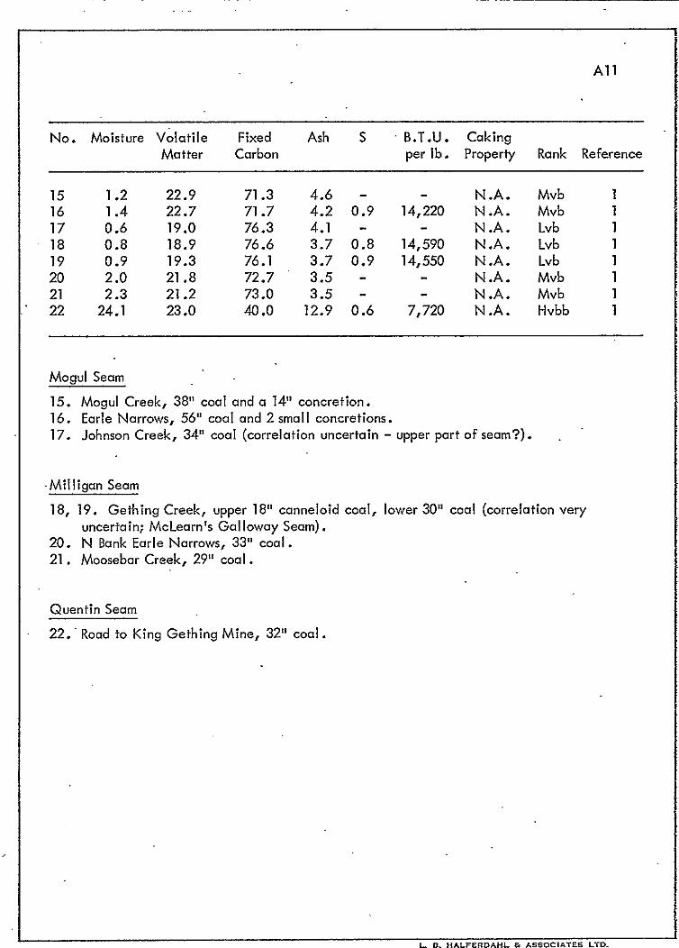
CORRELATION OF COAL SEAMS
More than 60 coal seams were noted by McLearn in the Gething
Formation along the Peace River Canyon in 1922. Many of these are less
than one foot thick, but 20 are two feet or more thick in at least one place.
McLeorn named most of the thicker seams in Table 3; two or three other seams
Page 27
22.
TABLE 3: THICKER COAL SEAMS IN GETHING FORMATION
Coal Seam Depth Below Coal Seam Depth Below .
Moosebar Formation Moosebar Formation
(feet) (feet)
Superior
Trojan
Titan
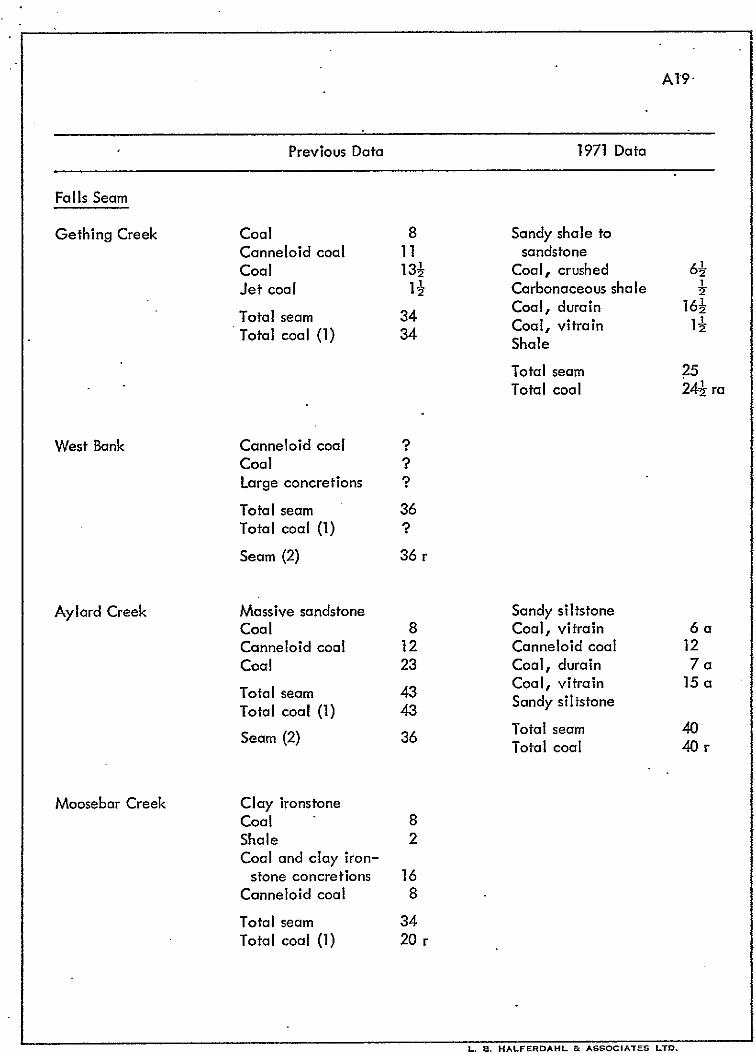
Falls
Gething
Little Mogul
Mogul
Castle Point
Milligan
Gal loway
Wendy
Louise
‘15 - 28
90 - 115
155 - 210
225 - 251
296 - 312
338 - 455
348 - 454
428 - 526
452 - 575
577
493 - 610
536 - 665
Ferro Point
Quentin
Index
Grant
King
Riverside
Knight
Upper Twin
Lower Twin
Boring
“48”
Murray
552 - 692
748 - 838
882 - 1055
1014 - 1135
1130
1134 - 1168
1240
1307
1319
1481
1470
1606
are included. Many of the seams have been correlated by McLearn (1923),
McLearn and Kindle (1950), and Stott (1968), (1969) but some of their
correlations are not well established. Nevertheless, in the attempted
correlation of all the thicker coal seams in the Gething Formation in and
near the Peace River Canyon, some of the previous uncertain correlations
of McLearn ond Stott have been retained because data were insufficient for
reliable changes. The correlations of the seams in Fig. 12 are based on their
stratigraphic distances below the Gething-Moosebar contact, their thicknesses,
their vertical variations in lithology and analytical data, and projections from
their outcrops.
The Superior, Trojan, and Titun Seams, all within the upper 210
feet of the Gething Formation, have been traced along strike from Gething
Page 28
23.
Creek southeasterly to Coalbed Creek, and thence northeasterly to Contact
Point, and the Trojan Seam across the Peace River to King Creek, a distance
of more than 11 miles, mostly on the properties of Cinnabar Peak Mines Ltd.
Why the thickness of the Trojan Seam at Moosebar Creek measured by both
McLearn and Stott is less than at the other locations is uncertain.
The Falls Seam has been traced along strike from Gething Creek
southeasterly to Johnson Creek, a distance of more than 6 miles. Its conti-
nuation to Mount Johnson and thence northeasterly to the Peace River near
Contact Point is expected to be established by further work.
The Gething Seam was named by McLearn for a seam below the
Falls Seam on Gething Creek. Although stratigraphic measurements are
insufficient for certainty, this seam has been correlated with one approxi-
mately 300 feet below the Gething-Moosebar contact on the West Bank and
along Aylard Creek.
According to McLearn; the Mogul and Little Mogul Seams are 10
feet apart. Two seams uncovered by the trenching on Mount Johnson are
8 feet apart, have thicknesses comparable to the Mogul and Little Mogul
Seams elsewhere, and from projections appear to be in the correct strati-
graphic part of the Gething Formation. Accordingly they have been
correlated with the Mogul and Little Mogul Seams. Al though McLearn
indicated that the Little Mogul Seam extends from Earle Narrows to
Moosebar Creek, a distance of about 24 miles, and becomes much thinner
at both places, if the above correlation is correct, it extends at least 5
miles from Eorle Narrows to Mount Johnson. A seam tentatively correlated
with the Little Mogul was located on Johnson Creek. With the preceding
correlation, the Mogul Seam also extends at least 5 miles from Earle Narrows
to Mount Johnson. There is some doubt about the correlation of the Mogul
and Little Mogul Seams on Moosebar Creek because although Stott and
McLearn apparently located these seams at the same place, Stott measured
a much smaller interval between the Titan and Mogul Seams. The Mogul and
Little Mogul Seams were not identified in the drilling at Dam Site #2 because
Page 29
i4.
the seams where they might have been expected had been burned. ’
The Castle Point and Miiligan Seams are from 15 to 20 feet apart.
Although both have not been located on Gething Creek, there the Galloway
Seam has been correlated with the Milligan, and both probably extend 61
miles from there to at least Mount Johnson where two seams about 10 feet
apart and apparently in the correct stratigraphic position have been correlated
with them. The correlation shown on Moosebar Creek in Fig. 12 is based on
Stott’s sequence of seams, and because of the smaller interval between the
Titan and Mogul Seams as previously explained, the distance below the
Gething-Moosebar contact for the Castle Point and Milligan Seams on
Moosebar Creek is up to 100 feet less than elsewhere.
The Wendy and Louise Seams are named herein for two seams
between the Milligan and Ferro Point Seams. Both have been correlated
from the West Bank in the upper Canyon to Moosebar Creek, with the Wendy
beyond to Johnson Creek.
The Ferro Point Seam extends for at least 4 miles from the West Bank
‘of the upper Canyon southwesterly as far as Moosebar Creek, and possibly
farther.
The Quentin Seam was described by McLearn and Irish OS being
about 320 feet stratigraphically above the King Seam. In this report, a
seam apparently at about the same stratigraphic level in the Gething
Formation has been correlated with the Quentin Seam in the upper Canyon,
at Dam Site #2, and at Moosebor Creek.
The Grant Seam has been correlated with the King Seam on the
basis of its apparent stratigraphic position in the Gething Formation, similar
thickness and ranks of coal, and a bottom bench of iet coal with an F.S.I.
of 53 in the Aylard Mine and with good caking properties in the King Gething
No. 1 Mine. A 60-inch seam encountered in drilling at Dam Site #2 also
has been correlated with the Grant Seam. If these correlations are correct,
then the Grant-i<ing Seam exte’nds for about 8 miles along strike from near
Aylard Creek to King Creek. It seems reasonable to expect a length similar
.
Page 30
25.
to fhose of the Superior, Trojan, and Titdn Seams.
A seam on the West Bank of the upper Canyon has been correlated
by Stott with McLearn’S Riverside Seam about 30 feet below the Grant Seam
at the Aylard Mine. This is a distance of about 4 miles; drilling is required
to obtain intersections between these points and to extend the Riverside Seam
beyond them.
The Knight, Twin, and Boring Seams were named by McLearn and
Irish on ihe East Bank of the upper Canyon, and subsequently noted on the
West Bank by Stott. They have not yet been extended beyond the upper
Canyon.
The Murray Seam of the upper’canyon has been correlated with the
“48” Seam of the King Gething No. 3 Mine and nearby drill holes on the
basis of similar stratigraphic positions in ihe Gething Formation, thicknesses,
coal ranks, and analytical data. The difference of about 160 feet in strati-
graphic thicknesses - about 500 feet between the Grant and Murray Seams in
the upper Canyon and about 340 feet between the King and “48” Skams at
King Creek - does not appear unreasonable in a lateral extent of 11 miles.
0 CHARACTERISTICS OF COAL SEAMS
Descriptions of coal seams and analyses of coal samples are presented
in the appendices. In general, where outcrops are sufficient to permit reliable
correlation and samples have been analyzed, the coal seams appear to have
’ little lateral variation in thickness and in analyses of the coal. They do vary
laterally in both presence and thickness of partings and ironstone concretions.
The chief variations in each seam are stratigraphic: ash contents, free swelling
indexes or caking properties vary from bench to bench. The analyses indicate
that most of the coal is low or medium volatile bituminous, with a few samples
being high volatile bituminous. Ash contents seldom exceed 20 per cent with
many less than 10 per cent, particularly in the.thicker seams. Only one of 39
samples that have been analyzed for sulfur contciins more than one per cent.
Page 31
26.
Partial analyses of the samples collected in 1971 are shown in
Appendix 6. As most of these samples were collected from outcrops and
were expected to be more or less oxidized, only moisture, ash, and free
swelling index were determined for preliminary evaluation. Even though
the samples were partly oxidized, free swelling indexes in the range 4 to
8 were obtained consistently for the Superior and Trojan Seams, both near
the top of the Gething Formation in a similar stratigraphic position to the
well-known Chamberlain Seam of excellent coking quality currently being
explored south of Chetwynd near the Sukunka River. Other significant free
swelling indexes were obtained at some places or from some benches of the
Mogul, Grant, and Knight Seams, and an unnamed seam 36 feet below the
Mil I igan Seam on Johnson Creek. Hence, it appears that rapid mechanical
erosion of the coal in some creek beds and at some places along canyon walls
can prevent oxidation from reducing free swelling indexes to insignificant
values. However, high moisture contents in samples of the 60-inch seam
exposed in a bulldozed trench away from creeks on Mount Johnson indicate
that oxidation may have been responsible for the non-agglomerating coal
samples. For this reason, not all samples collected’from Mount Johnson
were analyzed. In order to obtain less-oxidized samples from the Trojan
Seam, trenches were blasted at two places: Coalbed Creek and Lower
Moosecall Creek (Table 4). A parting ranging from 2 to 4 inches in the’
Trojan Seam on Coalbed Creek has been included in the lower 20-inch
bench. The low free swelling index in the upper 20-inch bench is probably
due partly to the higher ash content and partly to oxidation. At Lower
Moosecall Creek, the ash contents of about 20 per cent in the 36-inch and
15inch benches have apparently reduced their free swelling indexes.
linoxidized coal from the Trojan Seam after any required processing to
reduce the ash content to an acceptable value is expected to have a free
swelling index of 8 or more. Although coke-oven tests of large unoxidized
samples are required to assess adequately the coking quality of coal, the
free swelling index is-generally regarded as a good indicator. Free swelling
Page 33
28.
indexes in the range 5 to 9 are characteristic of the better western Canadian
coking cools.
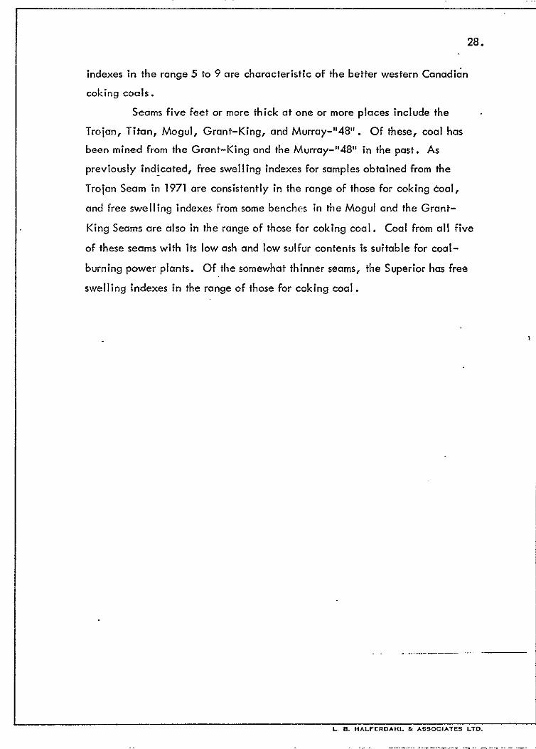
Seams five feet or more thick at one or more places include the
Trojan, Titan, Mogul, Grant-King, and Murray-“48”. Of these, coal has
been mined from the Grant-King and the Murray-“48” in the past. As
previously indicated, free swelling indexes for samples obtained from the
Trojan Seam in 1971 are consistently in the range of those for coking coal,
and free swelling indexes from some benches in the Mogul and the Grant-
King Seams are also in the range of those for coking coal. Coal from all five
of these seams with its low ash and low sulfur contents is suitable for coal-
burning power plants. Of the somewhat thinner seams, the Superior has free
swelling indexes in the range of those for coking coal.
RESERVES
Information for estimating coal reserves on the Peace River Canyon
properties of Cinnabar Peak Mines Ltd. consists of measured thicknesses of
coal seams at tntervals ranging up to three or more miles apart and the
correlations made in a preceding section. An average of measured thicknesses
for each seam, unweighted for length of projected outcrop nor for area, is
used as the average thickness of the seam. At some locations measured, the
thickness used is greater than the sampled thickness because part of the seam
was covered when sampled. The area underlain by each seam on the properties
has been measured from seam outcrops and projections of traces of seam outcrops,
after allowing for mining restrictions within one-quarter mile of the 1650-foot.
contour, which is the reservoir level of a second dam proposed by the British
Columbia Hydro and Power Authority. In measuring the area underlain by
each seam, traces of outcrops hove not been projected along strike for more
than one mile beyond the last outcrop except for the Superior, Trojan, Titan,
Grant-King, and Murray-“48” Seams, whose thickness, or continuity, or both
Page 34
is.
provide bases f&projecting them farther along strike. Indicated reserves
mean coal within one mile of the seam outcrop or within one mile of its
projected trace in Fig. 4. inferred reserves mean coal beyond one mile of
the seam outcrop or its projected trace. For measuring the areas underlain
by seams with limited outcrops in the upper Canyon, in the middle and lower
parts of the Gething Formation, the Peace River has been arbitrarily chosen
as the trace of the projected outcrops. For seams or parts of seams whose
traces are not projected in Fig. 4, approximate traces have been used.
The reserve estimates for all the seams with average thicknesses
greater than 20 inches are given in Table 5. For the Grant-King and
Murray- .“48” Seams the indicated reserves and the areas used to determine
them have been subdivided as follows:
Grant-King Murray-“48”
Area within one mile of outcrop (sq. mi.)
Area within one mile of projected trace
of outcrop (sq. mi.)
Reserves within one mile of outcrop
(thousands of tons)
Reserves within one mile of projected
trace of outcrop (thousands of tons)
2.7 0.5
4.5 4.7
15,292 2,592
25,488 24,364
Indicated reserves total 402,233,OOO tons and inferred reserves 687,824,OOO
tons. For seams with average thicknesses of more than 45 inches, indicated
reserves,total 244,738,OOO tons and inferred reserves 454,206,OOO tons. The
analyses in Appendix 6 indicate that coal in the Trojan and Superior Seams
is potentially of coking quality. Presently estimzrves in these seams
are 108,585,OOO tons indicated and 142,876,OOO tons inferred for a total
of 251,461,OOO tons. Analyses of samples from some of the other seams have
free swelling indexes which may indicate coking or blending quality. The
coal in the other seams is mostly low to medium volatile bituminous, with
less than one per cent sulfur and mostly low ash, making it suitable for use
.
Page 35
30.
TABLE 5: PRELIMINARY ESTIMATE OF COAL RESERVES ON PEACE RIVERS CANYPN
PROPERTIES OF CINNABAR PEAK MINES LTD.
Seam
Area of Seam Reserves
Range of Average (Thousands of Tons)
lnd%Ze ?!tZred Thickness Thickness * Indicated Inferred
(inches) (inches) Reserves Reserves
1 * See text for a subdivision of these figures. I
Superior 24 - 48
Trojan 43 - 100
Titan 2a- a4 Fal Is 20 - 495
Gething la- 25
Little Mogul la- 35
Mogul 42 - 65
Castle Point 25 - 48 Milligan 24 - 48 Wendy la- 54
Louise 23 - 48
Ferro Point 26 - 33
Quentin
North of Peace River 264
South of Peace River 24 - 54
Grant-King
North of Peace River 663
South of Peace River 36 - 79 Riverside 33$- 42
Knight 36 - 364
Upper Twin 21 - 24
Lower Twin 25& 27;
Boring 32
Murray-“48”
North of Peace River 97
South of Peace River 36 - 73
TOTAL of all seams listed
34 11 .o 15.2 67 ’
35,904 49,612 11.3 14.5 72,6$ 93,264 fl
48 11.2 16.2 51,609 74,649
34 5.2 5.2 16,972 16,972
22 1.5 2.6 3,168 5,491
26 5.4 10.1 13,478 25,209
51 6.3 10.3 30, a44 so;428
35 5.9 10.8 19,824 36,288
33
32 2;
10.8 18,691 34,214
5.7 13,824 17,510
34 3.0 3.8 9,792 12,433
30 1.5 I .a 4,320. 5,184
26 0.3 36 1.5
661 1.1
59 7.2*
36 2.9
36 0.5 22 . 0.5
26 0.5
32 0.5
97 / 1.6
54 5.2*
1.8
748 -
5,184 6,220
21.9
4.2
6,969 - ti 40,780* 124,041
10,022 14,515
1,728 -
1,056 -
1,248 -
1,536 -
23.5
14,899 - J
26,956* 121,824
TOTAL of seams with average thicknesses less than 32”
TOTAL OF seams with average thicknesses 32” to 45”
TOTAL OF seams with average thicknesses more than 45”
402,233 687,824
24,018 35,884
133,477 187,734
244,738 464,206
402,233 687,824
Page 36
.31.
in coal-burning power plants.
insufficient data are available to give more than a very rough
estimate of the amount of the preceding reserves that are suitable for strip .
mining. North of the Peace River near the King Gething Mines with
stripping to a depth of about 150 feet on the 66-inch King Seam, approxi-
mately 330,000 tons are available, and on the 97-inch “48” Seam 750,000
tons, for a total of just more than one million tons. Thin seams above the
King and the “48” Seams will not greatly change these figures. Probably
the most favorable place for stripping is on the south side of Mount Johnson
where bulldozer trenching uncovered many coal seams ranging up to 60 inches
thick. On the south end of Mount Johnson, these seams are close to a dip
slope; to the northwest along strike they have not been trenched. Never-
theless, in one trench 4 seams ranging from 28 to 60 inches for a total of
more than 13 feet of coal are present in a stratigraphic interval of less than
80 feet. This increases to 8 seams ranging from 16 to 60 inches for a total
of 19 feet of coal in a stratigraphic interval of about 140 feet. These seams
dip mostly between 30 and 40 degrees in the trenches, but have lower dips
to the south. They may be close enough to the surface along a strike length
of 6000 feet and down the slope as much as 2000 feet so that from 5,000,OOO
to 8,000,OOO tons of coal may be suitable for strip mining there. Other
seams higher in the Gething Formation such as the Falls, Titan, and Trojan
are also to be expected on or near the dip slope on the south end of Mount
Johnson at progressively lower elevations. Parts of these same seams are
also expected in the drift-covered relatively flat area along the upper part
of Coalbed Creek and between it and the logging road under overburden
that may be shallow enough, for stripping. Thus it is possible that an area
of $ of a square mile is underlain by an additional 10,000,000 to 13,000,OOO
tons of strippable coal totalling 15 feet in more than one seam. Additional
strippable coal may be present on the west flank of Mount Johnson.
Page 37
32.
TRANSPORTATION
The Pacific Great Eastern Railway traverses the Pine River Valley
within 18 to 20 miles of the coal properties of Cinnabar Peak Mines Ltd.
C&e possible route for a spur line would involve leaving the P .G .E. about
25 miles west of Chetwynd near Hulcross near the confluence of Brown Creek
with the Pine River, crossing the Pine River, ascending the lower part of the
southeast flank of Mount Hulcross, crossing a divide with elevations less than
3500 feet, thence down Hulcross Creek to the Moberly River, crossing the
Moberly River and ascending it to Pete Creek, up Pete Creek to Pete Lake at
an elevation of less than 3000 feet, and thence down Burnt Trail Creek to its
confluence with Johnson Creek. Without careful consideration of grades, the
length of this spur cannot be estimated precisely, but is expected to be
between 40 and 50 miles. The route as far as Pete Creek might be the one
chosen for the Carbon Creek coal field. An alternate route leaves the
Chetwynd-Fort St. John line of the P.G.E. east of Moberly Lake near Demean
or Bond, thence west past Moberly Lake and up the Moberly River. A spur line
along this route is estimated to be 30 miles longer with about 35 more miles on
the existing P.G.E. past Hulcross, but would eliminate a bridge across the
Pine River.
Shipping of large amounts of commodities such as coal is leastexpensive
if unit trains are used. Such trains shuttle back and forth between origin and
destination with delays only for loading, unloading, crew changes, fueling, and
maintenance. Freight cars are specially designed to permit bottom dumping,
sometimes even while moving, or side dumping or inversion without uncoupling.
In the eastern and central United States typical unit-train rates for shipping one
to three million tons of coal annually for distances of 130 to 450 miles range
from about 0.4 to 0.8 cents per ton-mile with the lower rates generally applying
to the longer hauls. In western Canada unit-train rates for hauling coal to
Vancouver or Roberts Bank range from about 0.4 to 0 55 cents per ton-mile
for distances of about 675 to 750 miles. With the rail distance estimated at
Page 38
33.
700 miles from the coal properties of Cinnabar P,eok Mines Ltd. to North
Vancouver via the P .G .E. or slightly less to Prince Rupert via the P .G .E.
and C.N.R., the rates for hauling about two million tons of coal annually
in unit trains are estimated as follows:
6.4 cents/ton-mile $ 2.80/tori
0.5 cents/ton-mile ‘$ 3.50/tori
0.6 cents/ton-mile $4.20/tori
In order to use unit trains, considerable improvements to existing railroad
beds may be required. It unit trains ctre not used, freight costs to Vancouver
or Prince Rupert may be double the above unit-train rates.
Handling at the port is estimated to cost $1 .OO to $2.00 per ton.
CONCLUSIONS
Twenty of the numerous coal seams in the Gething Formation,
ranging in average thickness from 22 to 97 inches, have been tentatively
correlated throughout the Peace River Canyon coal properties of Cinnabar
Peak Mines Ltd. Three seams at the top of the Gething Formation are
known to extend along strike for about 11 miles, and probably underlie
more than 25 square miles of the properties. Many of the other seams are
expected to have similar lengths and extents. Preliminary estimates of the
total reserves are 1,090,057,000 tons with at least 251,461,OOO tons of
potential coking quality. The remainder is mostly low to medium volatile
bituminous coal, some of which may also be of coking quality. Much of
that which is not of coking or blending quality is favored for coal-burning
power plants because of its low ash and its sulfur content of less than one
per cent. Much of the coal appears favorably situated for underground
mining with few dips exceeding 15’. Much additional data is required to
choose the best method: continuous mining, longwall, hydraulic, or
ploughing. As much as 20,000,OOO tons, much of it near a dip slope, may
Page 39
34.
be suitable for strip mining. With the worldwide demand for coking coal,‘
the shortage of energy supplies for power generation, and the proximity to
an existing railway, the Peace River Conyon.coaI properties of Cinnabar
Peok Mines Ltd. warrant substantial expenditures to obtain the geological
and engineering data required for further evaluation of the feasibility of
their being placed in production.
Respectfully submitted,
Edmonton, Alberta December 30, 1971
G. A. Checklin, B.Sc., P. Eng.
LA/*
L. B. Halferdahl, Ph.D., P. Eng.
Page 40
35.
REFERENCES
Alberta Study Group (1954) - Lower Cretaceous of the Peace River region in
Western Canada Sedimentary Basin, Rutherford Mem.
Vol.; Am. Assoc, Petrol. Geol., Tulsa, Okla., p. 268-278.
Beach, H .H ., and Spivak, J. (1944) - Dunlevy-Portage Mountain map-area,
B.C.; Geol. Surv. Can. Paper 44-19.
Dolmage, V. and Campbell, D .D. (1963) - The geology of the Portage Mountain
damsite Peace River, B.C.; Can. Inst. Min. Met. Trans.,
v. 66, p . 308-320.
Galloway, C.F.J. (1913) - The coal measures of the Peace River Canyon;
Ann. Rept. B.C. Minister of Mines for 1912, pp. 125-136.
Galloway, J.D. (1924) - Coal; Ann. Rept. B.C. Minister of Mines for 1923, pp. A136-40.
Graham, Charles (1946) - Peace River Coal Mines Ltd.; Ann. Rept. B.C.
Minister of Mines for 1945, pp. A174-5.
Hughes, J .E. (1964) - Jurassic and Cretaceous strata of the Bullhead succession
in the Peace and Pine River Foothills; B.C. Dept. of Mines
and Petrol. Resources Bull. 51.
Mathews, W.H . (1947) - Geology and coal resources of the Carbon Creek-. _ Mount Bickford map-area; B.C. Dept. Mines Bull. 24.
and Graham, Charles (1946) - King Gething Mine; Ann. Rept.
B.C. Minister of Mines for 1945, pp. A172-3.
McLearn, F.H. (1923) - Peace River Canyon coal area, B.C.; Geol. Surv. Can.,
Sum. Rept. 1922, pt. B, pp. l-45.
and Irish, E.S.W. (1944) - Some coal deposits of the Peace
River Foothills, British Columbia; Geol. Surv. Can.
Paper 44-15.
and Kindle, E .D. (1950) - Geology of northeastern British
Columbia; Geol. Surv. Can. Mem. 259, pp. 63-7, 73-84, 154-76, and Figs. 11 and 14.
.
Page 41
‘36.
Millar, J .F .V. (1969) - Preliminary report on Portage Mountain coal properties: Cinnabar Peak Mines Ltd.; James Millar and Associates Ltd., Calgary, 31 pp., 2 appendices, unpublished.
Stott, D. F. (1967) - Jurassic and Cretaceous stratigraphy between Peace and Tetsa Rivers, northeastern British Columbia; Geol. Surv. Can. Paper 66-7.
(1968) - Lower Cretaceous Bullhead and Fort St. John Groups, between Smoky and Peace Rivers, Rocky Mountain Foothills, Alberta and British Columbia; Geol. Surv. Can. Bull. 152.
(1969) - Fernie and Minnes strata north of Peace River, Foothills of northeastern British Columbia; Geol.. Surv. Can. Paper 67-19, Part A and Part B.
(1969) - The Gething Formation at Peace River Canyon, British Columbia; Geol . Surv. Can. Paper 68-28.
Page 42
37.
CERTIFICATE
I, Laurence B. Halferdahl, with business and residence addresses
in Edmonton, Alberta, do hereby certify that
1. I am a registered Professional Geologist and Professional
Engineer in. the Province of Alberta and a licensed Professional
Engineer in the Province of British Columbia.
2. I am a graduate of Queen’s University, Kingston, Ontario
(B.Sc. in 1952 and M.Sc. in 1954 in Geological Sciences
in the Faculty of Applied Science) and of The’Johns Hopkins
University, Baltimore, Maryland (Ph.D. in 1959 in the
Department of Geology).
3. From 1957 to 1969 I was on the staff of the Research Council
of Alberta as a mineralogist and geologist where I was in
charge of the mineralogy laboratory and conducted various
field and laboratory investigations.
4. Since 1969 I have been a consulting geological engineer
conducting and directing property examinations and
evaluations, and exploration programs for metallic minerals,
industrial minerals, and coal.
“C-The data in this report were obtained from published and
L
unpublished reports and from exploration on the properties .-
directed by G .A. Check1 in from July 4 to November 4, 1971,
and under my general supervision.
6. I have not received nor do I expect to receive any interest,
directly or indirectly, in the property described in this report.
Respectfully submitted,
Edmonton, Alberta
December 30, 1971
zJ./q~
L. B. Halferdahl, Ph.D., P. Eng.
. .
Page 44
-- ------ 1.. “. H*,.FE”DAI!L cz *550tIATEs ‘TO.
Page 45
A57
o APPENDIX 8: IRONSTONE CONCRETIONS .’
ironstone concretions have been tioted in and adjacent to some
of the coal seams in the Peace River Canyon. Any ironstone produced
with coal from these seams will be removed from the coal during its
processing. In order to learn if it might have any value as a by-product,
a sample from ironstone concretions in the shale overlying the Grant Seam
at the Aylard Mine was analyzed. It contained 27.1 per cent Fe; other
constituents are given in the accompanying assay report. This is a lower
iron content than some other ironstone concretions from Cretaceous strata
in western Canada, but with calcining or roasting, the iron content would
be increased to about 36 per cent. Although this does not appear particularly
en.couraging, until more is known about the range of composition of ironstone
concretions at the Peace River Canyon, the possibility of their becoming a
by-product should not be entirely discounted.
Page 46
. I .
. .
. . -
..’
OCEAN
U.S.A.
.~ CINNABAR PEAl: MINES LTD. HALFERDAHL & ASSOCIATES LTD.
EDMONTON, ALBERTA
Fig. 1.1 Loc+ion Map
PiACE RIVER CANYON PROPERTIES &wiry 05:o; myust 5. Isiyj 0 IO0 . 2co 300
tIIXZEI::.XT*:+M <ci, 1
SCALE IN A4llES I
I
Page 47
Chetwvr-’
L.B. HALFERDAHL &ASSOCIATES LTD.
Cinnabar Peak I
Brameda and associated companies
i _ ___
Railway, existing -c-
EDMONTON, ALBERTA :
Fig. 2 Access Map !
PEACE RIVER CANYON PROPERTIES i
0 IO 20 ?. 30 ; _- ..____
SCALE -IN MILE?---- ‘.~.-‘ : I
Drawn: LBH ; ‘.
De&rib& 1971 I-
B.C. Dept. Mines Map
Page 54
:. .“’ 1033
:I --~-._- . ...*. \
.I:
LEGEND
Lot No.
Coal Licence No.
Lease No.
1030
2061
1057 1056 _----- _---“-- -$j
1027 1026 G
/
1058 _-..-._ -
1028 . _ . __ _ ._ 1030 1031
1065 1064 1063 -_-__ _ __-__-- .-- _--_. 1035 1034 1033
1068 1069 -I--_^__ 1_-_- 1038 1039
1043
,.,: ;. :. ._. ;.,,:. ::.: ::-: ‘. ::.
1044
1042
1062
1032
; ..: ; ‘.. . . : ::. :: ;. :. : -. txprry Date: August
CINNABAR PEAK MINES LTD
L. B. HALFERDAHL & ASSOCIATES EDMONTON, ALBERTA
Fig. 3 Property Map
PEACE RIVER CANYON PROPERT
0 I 2, t 1
SCALE IN MILES’
IES
Page 60
APPENDIX 2: DRILLER’S REPORTS ;& TO GETHING MINE
Company: Cinnabar Peak Mines Ltd.
Drill Hole No. 1 Dip: -90’
Page 1
Total Length: 885’ Driller: T. Mullen, McAuley Drilling Co. Ltd.
Interval Description Interval Description
0’ - 20’ 20’ - 24’ 24’ - 31’ 31’ - 34.5’ 34.5’ - 42’ 42’ - 65’ 65’ - 71.5’
; 71.5’ - 72.5’ 72.5’ - 120’
120’ - 129’ 129’ - 142’ 142’ - 157.5’
157.5’ - 160.5’
160.5’ - 178’ 178’ - 182’
* 182’ .- 183.5’ 183.5’ - 188’ 188’ - 225’
225’ - 234’ 234’ - 235’ 235’ - 248’ 248’ - 250.5’ 250.5’ - 252’ 252’ - 273’ 273’ - 275’ 275 ’ - 283.5’
Silty clay Clay, gravel Silty clay’ Shale Sandstone Shale Soft shale Coa I Shale Sandstone, hard Grey shale Sandstone, hard below 144’; coal traces between 151’ and 154’ Grey shale, some soft bands Sandstone, hard Grey shale Coal; water Grey-brown shale Sandstone, hard;
283.5’ - 284’ 284’ - 286’ 286’ - 294’ 294’ - 302’ 302’ - 313’ 313’ - 350’ 350’ - 354’ 354’ - 354.5’ 354.5’ - 361’
361’ - 366’ 366’ - 385 5’
+ 385.5’ - 387’ 387’ - 394’ 394’ - 403’ 403’ - 445’
445 ’ - 447’ 447’ - 456 -5’
few hard shale bands; 456.5’ - 456.8’ coal traces between 456.8’ - 471’ 195.5’ to 196.5’ 471’ - 478’ Soft shale 478’ - 483.4’ Hard shale 483.4’ - 485’ Sandstone 485’ - 488’ Soft brown shale 488’ - 489’ Sandstone 489’ - 508.2’ Shale 508.2’ - 509’ Sandstone 509’ - 516’ Shale 516’ - 521’
Coal Shale Sandstone Shale Sandstone Shale Shale, hard Coal lnterbedded hard sandstone and shale; coal, traces 359’ to 360’ Sandstone, very hard Grey and brown shale Coal Brown shale Sandstone, hard Grey and brown shales; hard sandstone ledges; 0.5’ coal at 441’ Sandstone Shale Coal Shale Hard sandstone Shale Shaly coal Shale Sandstone Shale Shaly coal Shale Hard sandstone
Page 61
A5
Company: Cinnabar Peak Mines Ltd. Location: Road to Gething Mine ’
Drill Hole No. 2 Dip: -90°
Page 1 Started: December 13, 1969 Completed: December 18, 1969
Total Length: 820’ Driller: T. Mullen, McAuley Drilling Co. Ltd.
InteNal Description Interval Description
0' - 2.5’ 2.5’ - 34.0’
34’ - 39’ 39’ - 95.3’
95.3’ - 96’ 96’ - 105’
105’ - 129’ 129’ - 143.2’ 143.2’ - 144’ 144’ - 169’ 169’ - 174’ 174’ - 195.2’ 195.2’ - 195.8’ 195.8’ - 197’
197’ - 198.4’ 198.4’ - 199’
199’ - 199.6’ 199.6’ - 232.5’
232.5’ - 233.4’ 233.4’ - 262.9’
262.9’ - 264.5’ 264.5’ 265 ’ - 269.5’ 269.5’ - 271’ 271’ - 288.2’ 288.2’ - 288.6’
Soft exposed coal Sandstone, hard; shale bands Soft grey shale Sandstone, hard; shale interbedded Coal Sandstone, hard; shale bands Shale Sandstone Coal Shale Sandstone Chert Coal Brown shale; coal interbedded Coal Brown shale; coal interbedded Coal Grey shale; sand- stone interbedded Coal Grey-brown shale; hard .sandstone bands Coal Ran core barrel Cored Sandstone Shale Coal
288.6’ - 294’ 294’ - 301’ 301’ - 302.8’ 302.8’ - 303.5’ 303.5’ - 309’ 309’ - 322’ 322’ - 327’ 327’ - 328.5’ 328.5’ - 333.4’ 333.4’ - 350’ 350’ - 362’
362’ - 375’ 375’ - 395’
395’ - 397’ 397’ - 398.5’ 398.5’ - 406’ 406’ - 407’ 407’ - 424’ 424’ - 426’ 426’ - 429’ 429’ - 434’ 434’ - 435’ 435’ - 438’ 438’ - 465’ 465’ - 499.8’
499.8’ - 500 -2’ 500.2’ - 502.8’
Shale Sandstone Shale Coal Shale Sandstone Shale Coal Coil (cored) Shale Sandstone, hard; shale bands interbedded Chert, very hard Limestone, very hard Limestone Shale Shale Coal Shale Coal (cored) Shale Sandstone Shale Sandstone Shale Sandstone, hard; shale bands below 480’ Coal Brown shale; coal interbedded
Page 62
A4
Drill Hole No. 1 Page 2 .
Interval Description Interval Description
521' - 530'
530' - 533'
533' - 545.5'
545.5' ; 546'
546' - 550'
550' - 550 25'
550.5' - 567.8'
f567.8' - 574.8'
a L-575.4' -576; 574 8' - 575 4'
57.5; - 579.4'
579.4' - 580.3'
580.3' - 625'
625' - 632'
632' - 634.5'
634.5' -636'
636' -648'
648' - 659'
659' - 671'
671' - 692'
692' - 693.4'
* 693.4' - 695.8'
695.8' - 697'
697' -700'
700' - 709'
709' - 720.8'
720.8' - 721.4'
721.4' - 728.5'
728.5' - 729.3'
729.3' - 733'
4 733' - 735.4'
Hard shale
Sandstone, hard
Grey shale; sand-
stone interbedded
Coal Sandstone; shale
bands
Coal
Sondstone, hard;
few shale bands;
coal traces below
554'
Coal
Shale, hard, sandy
Coal
Brown shale;
coal traces
Coal
Sandstone, hard;
few shale bonds
Sandstone
Shale
Soft brown shale;
trace of coal
Shale
Sandstone
Limestone
Sandstone
Shale Coal
Shale
Limestone
Limestone, very hard
Grey brown shale,
hard
Coal
Grey shale;
sandy traces
Coal
Grey shale
Coal
735.4' - 737'
737' - 755'
755' - 764'
764' - 765.5'
765.5' - 766'
766' - 768'
768' - 775'
775' - 784'
784' - 787'
787' - 800'
800' - 830.3'
830.3' - 830.8'
830.8' - 832.5'
832.5' - 855'
855' - 874' 874' - 877.5'
877.5' - 885'
Grey shale
Sandstone; very
hard limestone
traces throughout
Sandstone Shale
Coal
Shale
Sandstone
Shale
Sandstone
Hard shale
Grey shale; coal
traces at 803 5’ to
806.5'
Coal
Grey shale Sandstone, hard
Grey shale
Sandstone, h&d
Grey shale
Page 63
A6
Dril I Hole No. 2 Page 2
Interval Description Interval Description
502.8’ - 531’
531’ - 534.5’
534.5’ - 555’
555’ - 568’
568’ - 576’
576 ’ - 592’
592’ - 598’
598’ - 610’
610’ - 624’
624’ - 627’
627’ - 634’
634’ - 639’
639’ - 642.5’
642..5’ - 650’
650’ - 683’
683’ - 690’
Grey shale
Brown shale; coal
interbedded
Sandstone, hard;
shale bands
Shale
Sandstone
Shale Hard grey shale
Soft black shale
Hard grey shale
Limestone
Limestone, very
hard
Grey shale; few
coal traces
Soft brown shale
Limestone, hard
Grey shale; sand-
stone bands
Limestone; sandy
690’ - 694’
694’ - 711.5’
711.5’ - 712’
712’ - 716’
716’ - 718.5’
718.5’ - 726.8’
726.8’ - 731.5’
731.5’ - 732’ 732’ - 748’
748’ - 764’
764’ - 774’
774’ - 779’
779’ - 782.8’ 782.8’ - 784.2’
784.2’ - 793.5’
793.5’ - 820’
Sandstone
Black shale
Coal
Grey shale
Black shale
Coal
Shale
Coal Shale
Sandstone
Shale
Limestone,
very hard
Grey shale Coal; few shale
traces
Grey shale
Sandstone;
limestone, very
hard
Page 64
A7
Company: Cinnabar Peak Mines btd.
Drill Hole No. 3
Dip: -90°
Page 1
Total Length: 415’
Location: Road to Gething Mine
Started: December 19, 1969
Completed: December 21, 1969
Driller: T. Mullen,
McAuley Drilling Co. Ltd.
Interval Description Interval Description
0’ - 3’
3’ - 6’
6’ - 18’
18’ - 30’
30’ - 66’
66’ - 741,
74’ - 76.8’
76.8’- 77.4’
77.4’ - 121’ 121’ - 123.8’
123.8’ - 124.3’
124.3’ - 130’
130’ - 143’
143’ - 147’
147’ - 192’
192’ - 198’
198’ - 212’
212’ - 212.5’
212.5’ - 232.2’
232.2’ - 235’
Clay
Sand
Broken shale
Soft shale
Shale
Sandstone, hard
Grey shale
Coal
Sandstone; shale Grey shale
Coal; shale traces
Grey shale
Shale
Sandstone
Soft shale
Hard shale
Soft shale
Shaly coal
Shale
Coal
235’ - 243.5’
243.5’ - 248.5’
248.5 ’ - 261.8’
261.8’ - 262.5’
262.5’ - 270’
270’ - 303’
303’ - 319.5’
319.5’ - 321.5’
321.5’ - 338.8’
338.8’ - 340.3’
340.3’ - 360’
360’ - 368’
368’ - 376’
376’ - 379’ 379’ - 379.5’
379.5’ - 393’
393 ’ - 397’
397’ - 415’
Shale
Coal
Shale
Coal
Shale
Grey shale
Sandstone, hard
Coal
Grey shale
Coal
Grey shale; few
sandstone barids;
coal traces from
357.5’ to 360’
Sandstone
Shale
Sandstone
Coal
Shale
Sandstone
Shale
.
Page 65
APPENDIX 1: TYPE SECTION OF MOOSEBAR FORMATION, CONTACT POINT, PEACE RIVER CANYON
(Measured by A. Kohil, September 23, 1971)
Lithology Thickness (feet)
Height above base (feet)
Moosebar-Gates Contact
Mudstone, dark grey, rubbly, recessive.
Covered.
Mudstone, silty, dark grey with brownish red rusty streaks on joint and fracture surfaces, rubbly with pieces 4” to $” with conchoidol-like shapes, dark grey weathering, weathering tends to round conchoidol shapes producing a conglo- merotic crppearance.
Mudstone, silty, dark grey, blocky with blocks to 8”.
Mudstone, silty, dark grey, rubbly with conchoidai pieces to -&‘I.
Mudstone, silty, dark grey, rubbly with conchoidal pieces to 2, abundant cloy ironstone concretions.
Mudstone, silty, dark grey, rubbly with conchoidof pieces to 2, some cloy ironstone concretions.
Shale, greenish block, glouconitic, recessive, fissility planes a few mm apart. _
Mudstone, silty, dark grey, rubbly with conchoidal pieces to &” increasing to 2” near top.
a5
60
1085
1000
105 940
5 835
380 830
70 450
57 380
1.7 323
36.3 321 .3
Page 66
:
A2
Lithology Thickness Height above (feet) base (feet)
Covered. 273 285
Mudstone, silty, dark grey, rubbly with conchoidal pieces to $‘, rusty spots possibly from weathering of pyrite.
Shale, greenish black, fissility planes a few mm apart.
Shale, greenish black, glauconitic, recessive, fissility planes a few mm apart.
7 12
0.5 5
0.4 4.5
Mudstone, silty, dark grey, rubbly with conchoidal pieces to $I, with clay ironstone lenses up to 3’ long and 2” thick oriented parallel to bedding. 4.1
Gething-Moosebar Contact marked by conglomeratic sandstone 14’ thick.
4.1
Page 67
Al4
APPENDIX 5: DESCRIPTIONS OF COAL SEAMS AT THE.PEACE RIVER CANYON
Previous Data* 1971 Data
Superior Seam
Aylard Creek Seam (2) 24
Moosebar Creek Seam (2) 48 r
Argillite Coal Sandstone
24 a
Total seam 24 Total coal 24 i
Contact Point Argillite Coal, vitrain Coal, vitrain Coal, vitrain (?) Coal, vitrain Coal, crushed Coal, vitrain Shale
Total seam Total coal
Lower Moose&II Creek Coal 33ra~
39 2
21 1
I2 3
31 31 ra
* Previous data are designated: (1) McLearn; (2) Stott; (3) B.C. Hydro drilling; (4) B. C. Minister of Mines Reports. All thicknesses are in inches. Thicknesses used for reserve estimates are designated r. Intervals with analyses in Appendix 6 are designated a.
Page 68
‘A15
Previous Data 1971 Data
Troian Seam
Gaylard Creek
Gething Creek
Aylard Creek
Coal 25
Sandstone 2
Coal 25
Sandstone 4
Coal 16
Total seam
Total coal (1)
Shale
Coal Sandstone
Coal
Sandstone
Coal
Sandstone
Coal
Sandstone
Coal
Shale
5 2
7
2
39
3
29
3
20
Total seam 110
Total coal (1) 100 r
Shale
Coal
Shaly sandstone
Coal
Shale Coal
Bone coal
Black carbonaceous
shole
Total seam
Total coal (1)
72
66 I
3
2
35
6 18
4
68 Seam
60 r Coal
Sandy siltstone
Coal, vitrain
Sandy siltstone
Coal, vitrain
Sandy shale
Coal, vitrain
Coal, clarain
Coal, vitrain
Base covered
.
2
3
6a
1
12 a
18a
50
47
43
Page 69
A16
Previous Data 1971 Data
Moosebar Creek Shale
Coal 25
Sandstone 4
Coal 18
Carbonaceous shale
Total seam 47
Total coal (1) 43 r
Coal, few small lenses
of coaly siltstone (2) 42
Johnson Creek
Coalbed Creek Canneloid coal
Coal
White argillaceous
sandstone
Coal
White argillaceous
sandstone
Coal
4i
194
2 24
4
30
Total seam 84
Total coal (1) 734
Shales
Coal
Parting
Coal
Parting
Coal
Shales
36
19
15
3s
13
Total seam 864
Total coal 64
Coal, clean 48 a
Sandstone parting 4
Coal 31 a
Total seam 83
Total coal 79 r
Lower Moosecall Creek Coaly shale
Coal
Parting
Coal
Parting
Coal
Coaly shale
Total seam
Total coal
31 a
19
15a
34
13 a
814
. 59 r
Page 70
A17
Previous Data 1971 Data
Contact Point
King Creek
Titan Seam
Gething Creek
West Bank Coal (2) 30 r
Aylard Creek Coal (2) 48 r
Coal
Arenaceous shale and sandstone
Coal
Total seam
Total coal (1)
32
54
42
128
74 r
Coal
Sandstone
Base covered
31 a
48
Seam
Coal
79
31
Coal, vitrain 4Oa
argillite mostly 48 Coal, vitrain 9
Dark grey sandstone,
some concretions 48
Coal, vitrain, well
cleated 9
Siltstone and sandstone
Total seam 1544
Total coal 584 r
Thin layers of sand-
stone and shale
Coal 48
Concealed 24
Shale and sandstone
Total seam 72
Total coal (1) 48 r
Sandstone
Coal, clarain 8
Canneloid coal 13
Coal, vitrain, well
cleated 10
Sandy si I tstone
Total seam 31
Total coal * 31 a
* 269 sampled. This may not be the Titan Seam, but a few feet below it.
Page 71
‘
Previous Data 1971 Data
Mdosebar Creek Dark shale
Coal 35
Shale and argillaceous
Johnson Creek
Contact Point
sandstone
Coal
Sandstone
Coal
Shale with i&t bands
Total seam Total coal (1)
Coal and few silty
lenses (2)
Shale
Coal
Clay ironstone
Coal
Sandstone
32
12
30
Total seam 74
Total coal (1) 62
60
49 r
54
Sandstone
Coal, durain 20
Coal, clarain 8
Sandstone and
carbonaceous shale
Total seam 28
Total coal 28 ra
Coal, clarain and
durain
Sandstone
Coal, vitrain
Total seam
Total coal
(n” sampled)
56
20
28
104
84 ra
.
Page 72
Al9
Previous Doto 1971 Data
Falls Seam
Gething Creek
West Bank
Aylard Creek
Moosebar Creek
Coal
Canneloid coal
Coal
Jet coal
Total seam
Total coal (1)
Canneloid coal ?
Coal ?
Large concretions ?
Total seam 36
Total coal (1) ?
Seam (2) 36 r
Massive sandstone
Coal Canneloid coal
Coal
Total seom
Total coal (1)
Seam (2)
Clay ironstone
Coal
Shale
Coal and clay iron-
stone concretions
Canneloid coal
8
2
16 8
Total seam 34
Total coal (1) 20 r
8
11
134
14
34
34
8
12
23
43
43
36
Sandy shale to
sandstone
Coal, crushed
Carbonaceous shale
Coal, durain
Coal, vitrain
Shale
Total seam
Total coal
Sandy siltstone
Coal, vitrain
Canneloid coal
Coal, durain Coal, vitrain
Sandy sil tstone
Total seam
Total coal
6a
12
7a
15a
40
40r
Page 73
A20
Previous Data 1971 Data
Johnson Creek
49 feet below Fal Is Seam
Johnson Creek
Gething Seam
Gething Creek Coal 6
Shale 1
Coal 22
Total seam 29
Total coal (1) 28
West Bank Seam (2) 18
Aylard Creek Coal, concretions,
canneloid coal (1) 32
Seam (2) 24r
Dark grey argillite
Coal, durain
Coal, vitrain
Coal
Coal,durain, clarain,
vitrain
Black argillite
21
3 3;
22
Total seam 49s
Total coal 494 ra
Sandstone
Coal, clarain
Coal, clarain
Coaly argillite
Total seam
Total coal
Shale and orgillite
Coal, clarain
Sandstone
Coal, clarain
Coal ?
Coal, clarain
Black carbonaceous
shale
l$a 3
13’a
3
84 a
Total seam 264
Total coal 25 r
4
16
20
20 ra
Page 74
‘A21
Previous Data 1971 Data
Little Mogul Seam
Earle Narrows Coal (I) 8
Aylard Creek Coal ?
Concretion 3
Coal ?
Total seam 36
Total coal (1) 33
Coal (2) 32;
Moosebar Creek Coal (1)
Coal (2)
Johnson Creek
Mount Johnson
11
18
Carbonaceous slate
Coal, vitrain
Coal, clarain
Coal and concretion
Coal, clarain
Coal, vitrain
Carbonaceous sandy
shale
4
7
15
6-i 24
Total seam 35
Total coal 35 ra
Shale
Coal, durain
Coal
Coal, shaly
Carbonaceous shale
8;
2;
14
Total seam 25
Totol coal 25 ra
Black shale
Coal
Coal with impurities
Coal
Shale
Total seam 26
Total coal 26 ra
12
6;
74
Page 75
A22
Previous Data 1971 Data
Mogul Seam
Earle Narrows. Coal ? ‘.. Concretion ?
Coal ? Jet coal 5 .
Total seam 56 Total coal (1) 56 r
Aylard Creek Coal Concretion Coal
2 4
40
Total seam Total coal (1)
Moosebar Creek Coal (1) 40
Coal (2) 42 r
Johnson Creek Shale Coal, clarain-vitrain 37 Argillite 9 Coal, vitrain 13
Total seam 59 Total coal 50 ra
Mount Johnson Shale Coal 2 Rusty coal 5 Coal 8 Rusty coal 3 Coal, dull 18 Coal with bright bands 12 Canneloid coal 9 Coal with bright bands 12 Dark shale Total seam Total coal 29’.
L. 8. HA‘FEROAH‘ PI *550clATE* LTD.
Page 76
A23
Previous Data 1971 Data
Castle Point Seam
West.Bank Carbonaceous shale
Coal
Clay ironstone
Coal
Shale
Coal
8
12
12
12
5
Total seam 49
Total coal (I) 25 r
Coal (2) 24
Aylard Creek Coal
Concretion band
Coal
Black carbonaceous
shale
Total seam
Total coal (1)
Moosebar Creek . Shale
Coal
Clay irons&e
Coal
Shale
Coal Shale
Coal
6 12
6
6
10
7
5
Total seam 52
Total coal (1) 27 r
Mount Johnson
? Top covered
4 Coal, clarain
? Shale
45
41 r
Sandstone
Coal, duroin 9
Shale 7
Coal 8
Shale to argillite
Total seam 24.
Total coal 17
18
Seam 18
Coal 18~1
Grey shale
Coal 6
Coal with red specks 7
Coal, good 35
Coaly shale
Total seam 48
Total coal 48 ra
Page 77
5
‘A24’
Previous Data 1971 Data
160 feet above Milligan Seam
Peace River Canyon
(Fossil Tree Point)
Milligan Seam
North Shore Coal and
concretions (1)
Coal (2)
West Bank Seam (2) 48 r
Aylard Creek Seam (1) 34
Seam (2) 36
Dam Site #2 Seam (3) 24 r
Moosebar Creek Seam (1)
Sandstone
Coaly shale
Coal
Sandstone
29
4
32
Total seam 36
Total coal (2) 32
30
18
Coal, vitrain
Coal; clarain
Total seam
Total coal
Coal, weathered Coal, durain
Concretions
Coal, clarain
Coal
Total seam
Total coal
Shale
Coal, clarain
Coal, clarain
Carbonaceous
sil tstone
27
7
Total seam 34
Total coal 34 ra
Black carbonaceous
shale
Coal, durain
Concretions
Coal, durain
Sil tstone
24
1
6
Total seam 31 a
Total coal . 30-r
2’
22
24
24 ra
13
14
10
5
3
45
35 ra
Page 78
A25
Previous Data 1971 Data
Johnson Creek
Mount Johnson
Galloway Seam (probably equivalent to Milligan Seam)
Gething Creek . . Canneloid coal 18
Coal 30
Total seam 48
Total coal (1) 48
Recessive unit
Coal, vitrain
Coal, clarain
Coal, vitrain
Sandstone
5 - 14
8
Total seam 27
Total coal 27 ra
Shale
Coal
Canneloid coal
Parting
Coal
Parting
Coal
Shale
Total seam. 30 a
Total coal 29 r
Shale
Canneloid coal
Coal, durain
Coal, vitrain
Argillite .
Total seam Total coal
13
24 a
20
39
39 r
Page 79
A26
Previous Data 1971 Data
Wendy Seam.
North Shore Seam (2)
West Bank
Aylard Creek
Moosebar Creek
Johnson Creek
Louise Seam
North Shore
West Bank
Aylard Creek
Dam Site #2
Seam (2) 18r
Coal and concretions 39
Jet coal 8
Total seam (1) 47 Total coal ?
Seam (2) 54 r
Seam (2) 36 r
Seam (2) 48 F
Coal and concretions 36
Total seam’ (1) 36
Total coal ?
Seam (3) 12
Coal, clarain 22
Coal, vitrain 5
Total seam 27
Total coal 27 ra
Page 80
A27
Previous Data 1971 Data
Moosebar Creek
Ferro Point Seam
North Shore
West Bank
Dam Site #2 Seam (3) 30 I
Moosebar Creek Seam (2) 14 .
Quentin Seam
West Bank Seam (2)
Dam Site #2 Seati (3) 54 I-
Seam (1)
Coal (2)
Seam (2)
Shaly argillite
Coal, clarain
Coal, vitrain
Carbonaceous shale
Coal, clarain
Carbonaceous shale
13
3
74
7
Total seam 30;
Total coal 23 ‘ra
26 r
24
48
Argillite
Coal, clarain
Coal, vitrain
Carbonaceous shale
Total seam Total coal
36 Carbonaceous shale
Coal, clarain
Argillite
Coal, clarain
Shale
9
10
20
Total seam 39
Total coal 29 ra
25
8
33
33 ra
Page 81
A28
Previous Data 1971 Data
Moosebar Creek Seam (i) 24 r
King Creek Bright and dull coal (1) 30 r
Grant Seam
North Shore Seam (2) 60
West Bank Seam (2) 36 i-
Dam Site #2 Seam (3) 60 r
Aylord Mine Coal Coal Jet coal
35
34
10
79
79 r
Total seam
Total coal (1)
King Seam (equivalent to Grant Seam)
King Creek Dull coal 84
Dull and bright coal 19
Shale 34
Bright and dull coal 7
Total seam 62
Total coal (1) 584
Top eroded Coal
Sandstone
Seam
Coal
26s
264
264
Cool 36
Coal 25
Seam 61 Coal 61 r
Coal
Coal
Parting
Coal
Coal
Total seam
Total coal
19 a
16 a 1
19:
10 a
644
64
Shale
Coal
Shale
66;
Total seam 66&
Total coal 664 r.
Page 82
A29
Previous Data 1971 Data
King Creek Carbonaceous shale
Coal 4
Bone 14
Coal 114
Concretions 18
Coal 12
Shale 1
Coal 24
Blacksmith coal 6
Total seam 78
Total coal (4) 574
Shale
Coal
Bone
Coal
Rock streak
Coal
Rock
Coal
Ironstone
5
4
7 1
2
4
31
Total seam 634
Total coal (4) 55
Riverside Seam
North Shore Seam (2)
West Bank Coal (2) 42 r
333 r
Aylard Mine Area Dark grey shiny cool ? Jet coal ?
Total seam 34
Total coal (1) 34 I
Page 83
A30
Previous Data 1971 Data
Knight Seam
East Bank Upper
Canyon
West Bank
Twin Seams
East Bank Upper
Canyon
West Bank
Coal Sandstone
Total seam
Total coal (1).
36
36
36 r
Upper seam, coal (1) 24 r
Siltstone 84
Lower seam, coal (1) 274 r
Sandstone
Coal (2)
Parting
Seam (2)
24
18
Shale
Coal, clarain
Coal, vitrain
Coal, clarain
Coal, durain
Coaly argillite
Argillaceous coal
Coal, vitrain
Coal, clarain
Argillite
124
2
2
6
2
2
74
6;
Total seam 4O$a
Total coal 364 r
Carbonaceous
si I tstone
Coal, vitrain
Coal, clarain
Carbonaceous clay Coal, clarain
Total upper seam
Total upper cool
1
8
1
12
22 a
21 r
Page 84
~ A31
Previous Data 1971 Data
West Bank (co&d) Carbonaceous argillite
Coal, durain Coal, duroin Coal, vitroin Carbonaceous
argillite
Total lower seam Total lower coal
72
5 19
13
254 25; ra
Boring Seam
East Bank Upper Canyon
Canneloid coal 18 Coal, shiny and dull 2 Black shale 9 Coal, shiny 12
Total seam 41 Total coal (1) 32 r
Seam (2) 36
West Bank Coal (2) 12r
Murray Seam (correlated with “48” Seam)
East Bank Upper canyon
Shale . Coal Clay ironstone Coal Clay ironstone Cool Shale
25 44
27 6
24
Total seam 864 Total cool (4) 73 r
West Bank Coal (2)* 36r
* It is uncertain whether this is the 7-foot seam worked in 1926 (Analyses 52-56, Appendix 4).
Page 85
A32‘
Previous Data 1971 Data
“48” Seam (equivalent to Murray Seam)
King Creek Sandstone Coal Inferior coal
Coal
Clay ironstone
Bottom coal
Total seam
Total coal (4)
Cool 36 a
19 Coal 28 a 9 Parting 11
51 Coal 42 a
8 18 Total seam 81
Total cool 70
105
97 r Coal .21a
Coal 10 a
Coal 15 a
Coal 17&a
Coal 14$cl
Total seam 78 Total coal 78
Page 86
A59
APPENDIX 9: FIELD PERSONNEL
Name Position Time on Property 1971
G. Checklin
B. Christensen
David Forester
Douglas Forester
J. Gorham
L. Halferdahl
Geologist
Assistant
Laborer
Laborer
Assistant
Geologist
F. Hewko
A. Kahil
K. Karpiak
L. Leffler
T. Lewis
D. Lobdell
G. Phillips
B. Redpath
T. Smith
Blaster
Geologist
Laborer
Laborer
Laborer
Geologist
Laborer
Assistant
Laborer
July 4 - November 4
July 6 - October 24
September 28 - November 3
October 6 - October 22
September 13 - September 21
June 1 I - June 12 July 4 July 17 - July 20 July 26 August 21 - August 22 August 28 - A.ugust 29 September 9 September 12 - October 2 - October 3 October 17 - October 18
August 28 - August 29
August 10 - September 29
August 7 - September 11
August 4 - August 31
October 11 - November 3
July 6 - July 26
September 8* - October 18
July 6 - September 5
September 7 - September 21
In addition to those above, casual- labor was hired for 16 days in July and August..
Page 87
CINNABAR PEA K MINES LTD.
1971 GEOLOGICAL EXPLORATION
OF
PEACE RIVER CANYON COAL PROPERTIES
NORTHEASTERN BRITISH COLUMBIA
Geographic Coordinates 55’ 56’ N 122O 8’ w
NTS Sheet 930/16E
‘G. A. CHECKLIN, B.Sc., P. Eng. and
L. B. HALFERDAHL, Ph.D., P. Eng.
December 30, 1971
L. 8. Holferdahl 8, Associates Ltd. 401 - 10049 Jasper Avenue
Edmonton 15, Alberta
Page 88
_.-
25.
CHARACTERISTICS OF COAL SEAMS
Descriptions of coal seams and analyses of coal samples are presented
in the appendices. In general, where outcrops are sufficient to permit reliable
correlation and samples have been analyzed, the coal seams appear to have
little lateral variation in thickness and in analyses of the coal. They do vary
laterally in both presence and thickness of partings and ironstone concretions.
The chief variations in each seam are stratigraphic: ash contents, free swelling
indexes or caking properties vary from bench to bench. The analyses indicate
that most of the coal is low or medium volatile bituminous, with a few samples
being high volatile bituminous. Ash contents seldom exceed 20 per cent with
many less than 10 per cent, particularly in the,thicker seams. Only one of 39
samples that have been analyzed for sulfur contains more than one per cent.
Page 89
.26.
Partial analyses of the samples collected in 1971 are shown in
Appendix 6. As most of thesa samples were collected from outcrops and
were expected to be more or less oxidized, only moisture, ash, and free
swelling index were determined for preliminary evaluation. Even though
the samples were partly oxidized, free swelling indexes in the range 4 to
8 were obtained consistently for the Superior and Trojan Seams, both near
the top of the Gething Formation in a similar stratigraphic position to the
well-known Chamberlain Seam of excellent coking quality currently being
explored south of Chetwynd near the Sukunka River. Other significant free
swelling indexes were obtained at some places or from some benches of the
Mogul, Grant, and Knight Seams, and an unnamed seam 36 feet below the
Mill igcm Seam on Johnson Creek. Hence, it appears that rapid ‘mechanical
erosion of the coal in some creek beds and at some places along canyon walls
can prevent oxidation from reducing free swelling indexes to insignificant
values. However, high moisture contents in samples of the 60-inch seam
exposed in a bulldozed trench away from creeks on Mount Johnson indicate
that oxidation may have been responsible for the non-agglomerating coal
samples. For this reason, not all samples collected from Mount Johnson
were analyzed. In order to obtain less-oxidized samples from the Trojans
Seam, trenches were blasted at two places: Coalbed Creek and Lower
Moosecall Creek (Table 4). A parting ranging from 2 to 4 inches in the’
Trojan Seam on Coalbed Creek has been included in the lower 20-‘inch
bench. The low free swelling index in the upper 20-inch bench is probably
due partly to the higher ash content and partly to oxidation. At Lower
Moosecall Creek, the ash contents of about 20 per cent in the 36-inch and
1.5inch benches have apparently reduced their free swelling indexes.
Unoxidized coal from the Trojan Seam after any required processing to
reduce the ash content to an acceptable value is expected to have a free
swelling index of 8 or more. Although coke-oven tests of large unoxidized
samples ore required to assess adequately the coking quality of coal, the
free swelling index is generally regarded as a good indicator. Free swelling
Page 90
27.
TABLE 4: ANALYSES OF COAL FROM TROJAN SEAM AFTER BLASTING
Residual Volatile Fixed Moisture Material Carbon
Ash S B.T.U. F.S.I. per lb.
Coalbed Creek
Top 20” 1 .46
Next 29” 1.43
Next 20” 1.25
Bottom 13” 1.53
Composite 82” - ,
Lower Moosecal I Creek
Top 36” 1.27
Parting 19”
Middle 15” 1.26
Parting 39
Bottom 13” 1.26
Composite 64” ;
23.22
30.07
33.13
34.09
24.81
24.16
29.56
-’
52.94
56.23
53.30
53.78
52.27
54.19
61.61
22.38 0.44
12.27 0.44
12.32 0.50
10.60 0.62
21.65 0.60
20.39 0.67
7.51 0.71
9,010 4
12,430 5;
11,580 7+
13,540 6+
6
11,570 44
1’1,760 4
14,010 84
5
Coalbed Creek: The upper two samples were collected about 6 feet in from the original outcrop-face. The lower two samples were collected abo& 10 feet in from the original outcrop face.
Lower Moosecal I Creek: The samples were collected about 5 feet in from the original outcrop face.
Page 91
28.
indexes in the range 5 to 9 are characteristic of the better western Canadidn
coking coals.
Seams five feet or more thick at one or more places include the
Trojan, Titan, Mogul, Grant-King, and Murray-“48”. Of these, coal has
been mined from the Grant-King and the Murray-“48” in the past. As
previously indicated, free swelling indexes for samples obtained from the
Trojan Seam in 1971 are consistently in the range of those for coking doal,
and free swelling indexes from some benches in the Mogul and the Grant-
King Seams are also in the range of those for coking coal. Coal from all five
of these seams with its low ash and low sulfur contents is suitable for coal-
burning power plants. Of the somewhat thinner seams, the Superior has free
swelling indexes in the range of those for coking coal.
Page 93
<.
APPENDIX 3: COAL SAmLED BY DRILLING
Analyses by~~.&TiZbora@& Ltd., Edmonton I’.
Footage Inherent 1
Volatile 2
Fixed, Ash B.T.U. F.S.I. S&m 3
Moisture Matter Carbon per lb.
Hole No. 1
182 -183
A 183 -184 w
,283 -284
568.5-570 0.3
570 -571 0.4
571 -572 0.4
q.“; 572 -573 0.4
573 -574 0.3
574 -575 0.4
575 -576 0.3
693.4-694.5 _ 0.4
&f694.5-695.5 0.4
695.5-695’.8 c-
733 -734
R,
0.4
0.3
20.8 57.4
24.3 71.2
25.5 58.3
16.5 57.6
15.6 1.8
18.2 76.3
17.7 76.3
19.4 76.3
20,8 72.1
30.1 29.2
21 .l 66.9
21.5 63.0
12.9 23.7
18.1 59.0
21.4 11,730
4.1 14,650
15.8 12,750
25.6 13,580
22.2 11,600
5.1 14,350
5.6 14,390
4.0 14,680
6.7 14,060
40.4 6,570
11.6 13,330
15.1 12,840
63.0 5,260
22.6 11,370
King
King -
94 feet.
below K$
“48”
“48”
“48”
“48”
“48”
“48”
“48”
117 feet
below “48”
117 fee; . below “48”
1 117 feet
below “48”
1 154 fee7
below “48”
1 Inherent moisture percentages are not available for samples marked with a dash. They are
expected to have the some range, 0.3 to 0.7, OS the other samples. Other data for these
samples is on a dry basis.
2 Stated OS free carbon in the.analytical reports.
3 Seams are based on corre.lations in this report, and distances are measured stratigraphically.
Page 94
A9
Footage Inherent Volatile Fixed Ash B.T.U.’ F.S.I. Seam Moisture Matter Carbon per lb.
735 -736 0.3 -
Hole No. 2
195 -196 -
196 -197 -
‘l:97- -198
198 -199 -
199 -199.5 e
A.‘-~ 327 -328.5
-328.5-331.5
718.5-720
720 -721
$3 721 -722
722 -723
723 -724
724 -725
725 -726
726 -726.8
Hole No. 3
0.7
0.3
232.2-233 -
234 -235 -
23.9 66.1
17.0 33.2
11.0 22.8
9.9 27.4
25.4 66.0
‘9.4 21.3
13.9 69.1
17.7 45.9
24.1 73.6
18.0 39.2
17.4 71.9
18.7 69.2
17.7 65.4
16.8 66.1
17.3 74.4
18.3 76.0
19.6 76.9
28.4 62.2
28.4 64.7
9.7
49.5
66.2
62.6
8.6
69.3
17.0
35.7
2.0
42.8
10.8
12.1
17.0
17.1
8.2
5.7
3.5
9.5
13,680
7,370
.7 154feet below “48”
3 154 feet below “48”
4,950
5,360
13,980
4,240
12,580
9,360
14,830
8,390
13,510
13,390
12,450
12,380
13,960
14,310
14,680
1 114 feet above King
N.A. 114 feet above King
7 114feet above King
N.A. 114feet above King
74 114feet above King
- 1 King
2 King
1 “4$-=-
1 “48”
1’ “48”
1 “48”
14 “48”
1 “48”
1 “48”
1 “48”
13,420 1; 92 feet above Quentin
. 6.9 13,950 7 92 feet above QuenGn
Page 95
APPENDIX
.---.- _---- ----- L. u. ,,*,.I-ERI,AHl. CI ASSCCIATES I.,,,.
Page 96
A10
APPENDIX 4: OTHER ANALYSES OF COAL FROM SEAMS AT THE PEACE RIVER CANYON
No. Moisture Volatile Fixed Ash S B.T .U . Caking Rank Reference*
Matter Carbon per lb. Property
1 1 .o 24.5 65.9 8.6 0.7 2 1.6 26.0 64.0 8.4 0.5
3 1.1 18.8 58.6 21.5 - 4 1.2 24.1 64.1 10.6 -
5 0.7 28.6 64.6 6.1 - 6 1.9 20.5 69.5 8.2 0.8 7 0.7 24.8 58.4 16.1 -
8 0.6 26.7 61.5 11.2 -
9 1.1 24.0 69.4 5.5 -
10 1 .o 23.8 71.9 - 3.3
11 0.9 25.9 70.9 2.3 -
12 0.8 20.7 71.1 7.4 0.07
13 1.0 25.2 70.3 3.5 -
14 2.7 24.3 62.5 10.5 -
13,820
13,350
12,853
13,820
N.A. N.A.
N.A.
Poor
Good
Agglom .
Good
Poor
N.A.
Poor
N.A. N.A.
N.A.
Mvb 1 Mvb 1
Mvb 1 Mvb 1
Mvb I Mvb 2
Mvb 1 Mvb 1 Mvb 1 Mvb 1 Mvb 1 Mvb 1 Mvb 1 Mvb 1
Trojan Seam
I. Gaylard Creek, 66” coal without 2 partings totalling 6”.
2. Gething Creek, 100” coal without 4 partings totalling 10”.
3, 4, 5. -Coalbed Creek, top 54” coal, middle benches 19” and 26” coal, lowest bench
upper 15” coal.
6. Coalbed Creek, sample interval not stated, F.S.I. -1, soft. 7, 8. Contact Point, upper ,32” coal, lower 42” coal.
Falls Seam
9, 10, 11. Gething Creek, top 8” coal, middle 11” coal, bottom 15” coal.
12. Johnson Creek, 49” coal (correlation uncertain).
Gething Seam
13. Gething Creek, 28” coal and a 1” parting.
Little Mogul Seam . .
14. Mogul Creek, 32” coal.
* 1 - McLearn & Kindle (1950); 2 - Millar (1969); 3 - McLearn & Irish (1944); a year refers to a B.C. Minister of Mines :eport.
Page 97
No. Moisture Volatile Fixed Ash S B.T.U. Caking
Matter Carbon per lb. Property Rank Reference
15 1.2 22.9 71.3 4.6 -
16 1.4 22.7 71.7 4.2 0.9
17 0.6 19.0 76.3 4.1 -
18 0.8 18.9 76.6 3.7 0.8
19 0.9 19.3 76.1 3.7 0.9
20 2.0 21 .8 72.7 3.5 -
21 2.3 21.2 73.0 3.5 -
22 24.1 23 .O 40.0 12.9 0.6
14,220
14,590
14,550
7,720
N.A.
N.A.
N.A.
N.A.
N.A.
N.A.
N.A.
N.A.
Mvb
Mvb
Lvb
Lvb
Lvb
Mvb
Mvb
Hvbb
Mogul Seam
15. Mogul Creek, 38” coal and a 14” concretion.
16. Earle Narrows, 56” coal and 2 small concretions.
17. Johnson Creek, 34” coal (correlation uncertain - upper part of seam?).
.Milligan Seam
18, 19. Gething Creek, upper 18” ccmneloid coal, lower 30” coal (correlation very
uncertain; McLearn’s Gal loway Seam).
20. N Bank Earle Narrows, 33” coal.
21. Moosebar Creek, 29” coal.
Quentin Seam
22.. Road to King Gething Mine, 32” coal.
Page 98
I
Al2
NO. Moisture Volatile Fixed Ash S B.T.U. Coking
Matter Carbon per lb. Property Rank Reference
23 0.8 20.4 75.4 3.4 - - Poor Lvb 1
24 0.6 23.6 72.4 3.4 - - Good Mvb 1
25 0.6 18.7 78.1 2.6 - - N.A. Lvb 1
26 0.7 24.6 72.6 2.1 - - Good Mvb 1
27 0.7 19.6 74.4 5.3 0.7 14,420 N.A. Lvb 1
28 0.6 19.5 77.0 '.2.9 0.7 14,940 N.A. Lvb 1
29' 0.7 22.0 70.8 6.5 0.7 14,440 Good Mvb 1
30 0.7 18.7 74.5 6.1 0.6 14,300 N.A. Lvb 1
31 0.8 19.3 n.3 2.6 0.7 14,960 Agglom. Lvb 1
32 0.7 22.9 74.0 2.4 0.7 15,130 Good Mvb 1
33 0.6 20.1 75.2 4.1 - - N.A. Lvb 1
34 0.6 19.5 77.3 2.6 - - N.A. Lvb 1
35 0.6 24.8 72.2 2.4 -’ - N.A. Mvb 1
36 1.3 16.5 78.9 3.3 - - - Lvb 1924
37 2.2 23.0 71.5 3.3 - - - Mvb 1924
38 1.1 18.5 75.5 4.9 - - - Lvb 1924
39 3.8 22.1 63.6 10.5 1.8 12,900 Agglom. Mvb 3
40 5.9 26.8 51.2 16.1 0.8 11,080 Agglom. Hvab 3
41 5.7 21.4 69.1 3.3 0.8 13,840 Agglom. Mvb 3
42 4.5 26.2 68.0 1.3 0.9 14,480 Good Mvb 3
43 1 .7 17.4 70.0 10.9 0.77 13,237 - Lvb 1940
44 0.7 18.8 74.9 5.6 0.8 14,000 Agglom. Lvb 1
Grant Seam at Grant Flat and Aylard Mine
23, 24. Cliff‘300’ W of W Xcut, middle and top 60” coal, bottom 9” coal.
25, 26. Cliff entrance to W Xcut, middle and top 54” coal, bottom 11” coal.
27, 28, 29. Adit 35’ from portal, top 38” coal, middle 23” coal, bottom 8” coal.
30, 31, 32. Adit at E Xcut, top 36” coal, middle 21” coal, bottom 9” coal.
33, 34, 35. Adit face, September 26, 1923, top 32” coal, middle 22” coal, bottom 9” coal..
36, 37, 38. Adit face, 1923, top 54” coal, bottom 11” coal; total 65” coal.
King Seam in King Gething No. 1 Mine
39, 40, 41, 42. Adit in 1943, top 8” coal, next 19” coal, next 24” coal, bottom 7” coal.
43. Adit face 1940, 57;” coal without partings or concretions.
Riverside Seam
44. Grant Flat 35’ below Grant Seam, 34” coal.
L. 8. HALFERDAHL % *S*OCIATES LTD.
Page 99
Al3
No. Moisture Volatile Fixed Ash S B.T.U. Caking Rank Reference
Matter Carbon per lb. Property
45 2.6 20.7 67.6
46 11 .o 21.7 52.4
47 11.0 22.2 57.5
48 3.5 20.3 70.4
49 2.3 20.5 69.0
50 2.2 19.5. 66.8
51 4.3 21 .6 68.5
52 0.6 17.0 79.0
53 0.6 16.9 80 .O
54 0.6 17.2 75.4
55 0.9 14.1 82.5
56 0.6 19.6 75.8
57 13.1 22.0 51.2
58 1.5 19.3 72.7
59 0.9 17.3 70.6
60 1.1 18.0 74.4
61 1.1 13.1 60.1
62 0.8 16.3 78.3
9.1 0.8 14.9 0.6
9.3 0.7
5.8 0.6
8.2 0.8
11.5 0.7
5.2 0.8
3.0 -
2.5 -
6.8 -
2.5 -
4.0 -
13.7 0.4
6.5 -
11.2 0.5
6.6 0.5
25.7 0.3
4.6 0;4
13,510 Poor 9,980 N.A.
11,870 N.A.
13,810 Agglom.
13,510 Agglom.
13,060 Agglom.
14,070 Good
9,750
13,830
13,370
13,658
10,608
13,932
‘N-A.
Mvb
Mvb
Mvb
Mvb
Mvb
Mvb
Mvb
Lvb
Lvb
Lvb
Lvb
Lvb
Mvb
Lvb
Lvb
Lvb
Lvb
Lvb
1
1
1 1
1
1
1
1926
1926
1926
1926
1
1945
1953
2
2
2
Knight Seam
45. River shore NE of Cust Island, 36” coal.
45. Trench on Galloway slope, 47” coal.
47. Trench on Galloway slope, lower 18” of previous sample.
Twin Seams
48. Boring Point, upper seam 24” coal. 49. Boring Point, lower seam 28’1 coal.
Boring Seam
50., 51. Boring Point, upper 18” coal, lowest 12” coal.
Murray Seam
52, 53, 54, 55, 56. S side upper canyon, benches 1 to 5 in 84” coal seam.
57. Trench near Larry Creek, 60” coal.
58. Peace River Mine No. 1 left level, 76” coal.
“48” Seam - King Gething No. 3 Mine
59. 88” coal without 9” inferior coal and clay ironstone; soft coke, no swelling.
60, 61, 62. Top 12” coal, F.S.I. 1 soft; middle 8” coal, F.S.I. 1 soft; bottom 52” coal,
F.S.I. 1 soft.
Page 101
A33
APPENDIX 6: 1971 ANALYSES OF COAL SAMPLES
(Analyzed by Loring Labbratories Ltd., Calgary)
Seam Sampled Inherent Ash
Interval Moisture
(inches)
F.S.I. Date Remarks*
Sampled
1971 .’
Superior Seam
Aylard Creek
Lower Moosecal I Creek
Contact Point
Troian Seam
Aylard Creek
Coalbed Creek
Contact Point
King Creek
Lower Moosecal I Creek
Titan Seam .
Aylard Creek
Johnson Creek
Contact Point
24 0.94 6.10
33 0.69 7.24
31 1.40 6.82
41 0.70
48 I .I7
4 (parting)
31 0.82
31 1.62
40 1.49
73 .99
6.28
14.29
14.95
12.69
10.10
11.44
264 0.83
28 1.11
30 1 .56
20 (parting)
47 1.41
6.70
5.98
10.14
4.61
Sept. 16
Oct. 14
July 18
Sept: 16
July 18
July 18
July 22
Aug. 29
July 25
Sept: 16
Aug. 18
July 18
1
2
1
1
1
1
3
1
1
1
1
3
* 1 - Creek sample; 2 - Trench; 3 - River bank; 4 - Trench No. 3; 5 - Canyon wall;
6 - Adit; 7 - West end of underground drift; 8 - Trench No. 2; 9 - Old trench;
10 - Outside odit; 11 - Face 8.50’ in main entry.
Page 102
i
.A34
Seam Sampled Inherent Ash F.S.1, Date Remarks‘
Interval Moisture Sampled
(inches) 1971
Falls Seam
Gething Creek 243 1.61 5.15 i- Sept. 18 1
Aylard Creek 28 1.33 4.65 i& Sept. 16 1
Johnson Creek 494 1.17 7.02 N.A. Aug. 17 1
49 feet below Falls Seam
Johnson Creek
Gething Seam
Gething Creek
Little Mogul Seam
Aylard Creek
Johnson Creek
Mount Johnson
Moaul Seam
Johnson Creek
Mount Johnson
Mount Johnson
20 1 .16
23 0.89
9 (parting) 13 1 .Ol
36 4.72
33 5.30
30 8.50
33 5.23
35
25
26
0.75
0.89
7.40
37 0.97
10.73 N.A. Aug. 16
17.84 4 Sept. 22
11.83 1: Sept. 15
47.40 .! Aug. 17
13.84 N4.A. Oct. 11
4.84 N.A.
5.31 24
6.18 N.A.
6.23 N.A.
9.73 N.A.
6.77 N.A.
Aug. 16
Aug. 16
Oct. 11
Oct. 11
Oct. 16
Oct. 16
1
1
1
1
4
1
1
4
4
.8
8
.
Page 103
A35
Seam Sampled Interval (inches)
Inherent Moisture
Ash F.S.I. Date Remarks Sampled .
1971
Castle Point Seam
Aylard Creek 18
Mount Johnson 23 25
Mount Johnson 44
160 feet above Milligan Seam
Peace River Canyon 24 (Fossil Tree Point)
1 .18 4.06 N.A. Sept. 15 1
7.00 19.50 N.A. Oct. 10 4 5.47 11.84 N.A. Oct. 10 4
4.20 7.89 N.A. Oct. 16 8
1 .40 5.28 N.A. Aug. 28 5
Milligan Seam
North Shore
Aylard Creek
Moosebar Creek
Johnson Creek
Mount Johnson
35 1 .80 5.76 N.A. Aug. 26 ‘5
34 2.37 5.18 N.A. Sept. 15 1
31 3.11 5.83 N.A. Aug. 21 1
27 1 .oo 6.62 4 Aug. 16 1
30 5.12 19.70 N.A. Oct. 10 ‘4
Gallowav Seam
Gaylard Creek
Wendy Seam
Johnson Creek
Louise Seam
Moosebar Creek
26.
27
23
.=
1.50
0.82
1 .43
2.21 N.A.
8.72 5-1;
11.66 1
Sept. 22 1
Aug. 16 1
Aug..21 1
Page 104
A36
Seam Sampled
Interval
(inches)
Inherent
Moisture
Ash F.S.I. Date Remarks
Sampled 1971
Ferro Point Seam
Peace River Canyon
(West Bank) 33 1 .52 18.34 N.A. Aug. 23
Quentin Seam
Peace River Canyon
(West Bank) 29 1 .39 12.25 1 Aug. 23
Grant Seam
Aylard Mine 36 0.96
25 0.92
19 0.97
16 0.91
4 (parting)
19 0.95
10 0.86
Kniaht Seam
Peace River Canyon 40s 1.21 8.13 2 Aug. 23
Twin Seam (Upper)
Peace River Canyon 22 2.46
Twin Seam (Lower)
Peace River Canyon 25& 1.28 22.14 4 Aug. 23
6.6i ‘. 2.64 l;
4.66 N.A.
3.20 $-
3.11 N’.A.
6.27 54
15;38 N.A.
July 20
July 20
July 26
Aug. 23
Page 105
Seam Sampled Inherent Ash F.S.I. Date
Interval Moisture Sampled Remarks
(inches) 1971
“48” Seam
King Gething Mine #3 36 10.24
King Gething Mine #3 28 0.83
11 (parting)
42 0.87
King Gething Mine #3 21 1.15
10 0.97
15 1 .15
174 1.05
144 1.32
Uncorrelated 30” Seam
(On road to Peace River 30 8.84
below King Gething Mine)
14.84
14.85
3.65
8.55
33.73
7.57
3.79
3.11
N.A.
N.A. )
1 N.A. )
NIA ;
N:A: )
N.A. )
+ 1
July 15 9
July 15 10
July 19 11
16.49 N.A. July 24 9
Page 106
APPENDIX 7: REPORTS OF COAL ANALYSES
Page 107
ROREHOLD SAwL!zS: REPORT OF ANALYSES ON RAW MATERIAL
A38
CLLENT: Mr. Halfer Dahl & Associates
PROJECT:
CLlRNT SAFlMaE NO.: 1576
DATE: Sept. 10, 1971.
C.E.S. PROJECT NO.: Sl-113
C.E.S. SAMPLE NO.: 1
ANALYSES ON AIR DRY BASIS:
ASH:
VOLATILE MAl-.Tl.?R:
RESIDUAL MOISTURE:
FIXED CARRON:
FREE SWELLING INDEX:
R.T.u./lll.:
SULPHUR:
t&K:
10.60%
34.09%
1.53%
53.78%
6%
13,540
0.62%
Page 108
RO1~HOLE SAMPLES:
A39
REPORT OF ANALYSES ON RAW MATERIAL
CLIENT: Mr. Halfer Dahl & Associates DATE : Sept. 10, 1971.
PROJECT:
CLlENT SAZ'LE NO.: 1577
C.E.S. PRCUECT NO.: Sl-113
C.E.S. SAMPLE NO.: 2
ANALYSES ON AIR DRY BASIS:
AS11: 12.32%
VOLATILE MATTER: 33.13%
RESIDUAL MOISTURE: 1.25%
FIXED CARDON: 53.30%
FREE SWELLING INDEX: 7%
B.T.U./lb.: 11,580
SULPHUH: 0.50%
RANK:
-_I
RmARKS :
C3.S. Form 17 CYCLONE ENGINEERING SALES LTD.
Page 109
ROREHOLE SAMPLES: REPORT OF ANALYSES ON RAW MATERIAL .
LZXENT: Mr. Halfer Dahl & Associates
PROJECT:
CLlENT SAMPLE hD.: 15SO
DATE: Sept. 10, 1971.
C.E.S. PR(UECT NO.: Sl-113
C.E.S. SAMPLE NO.: 3
ANALYSES ON AIR DRY BASIS:
hSfl : 12.27%
VOLATILE MATTER: 30.07%
RESIDUAL MOISTURE: 1.43% . .
FIXED CARBON: 56.23%
FREE SWELLING INDEX: 5%
B.T.lJ./lb.: 12,430
SULPliUK: 0.44%
RANK:
--
?.mAHKS:
._
C.S.S. IGm 17 CYCLONE ENGINEERYNG SALES LTD.
Page 110
A41
ROREliOLI~ SAMPEES-. REPORT OF ANALYSES ON RAW MATERIAL .
CLIENT: Mr. Halfer Dahl 6: Associates
PROJECT:
CLlENT SAMPLE hQ.: 1581
DATE: Sept. 10, 1971.
C.E.S. PROJECT NO.: 51-113
C.E.S. SAMPLE NO.: 4
ANALYSES ON AIR DRY BASIS:
ASH: 22.38%
VOLATILE MATTER : 23.22%
RESIDUAL MOISTURE: 1.46%
PXXED QW3ON: 52.94%
FREE SWELLING INDEX: %
B.T.U./Lb.: 9,010
SULPBUK: 0.44%
RANK:
. .
C.E.S. Form 17 CYCLONE RNGINEERZNG SALES LTU.
PC-: R.'S. Sehgal, Laboratory t'kln
Page 111
1 .
‘\,l , A42
ROREIIOLE SAWLES: REPORT OF ANALYSES ON RAW MATERIAL
CLIENT: L.B. Halferdahl & Associates Ltd. DATE: Oct. 22/71
I'ROJECT: C.E.S. PROJECT NO.: Sl-.113
CLIENT SAMFLE No.: 135 & 136 C.E.S. SAMPLE NO.: 5
ANALYSES ON APR DRY BASIS:
ASfi :
V03AlTI,E MATTKR :
RESIDUAL MOISTtIRE:
FIXED CARBON:
FRJ;E WELLING INDEX:
B.T"U./lb.:
SWJ'HUK:
IWNK :
20.39%
24.16%
1.26%
54.19%
4
11,760
0.67%
mvb
CYCLONE ENCIh~ERTNG SALES LTD.
Per: R. S. SchCaA, P. Ens. . I.abocatory &lIl‘3f x.
Page 112
‘A43
BOIUUOLI! SAiiLES: -
REPORT OF ANALYSES ON IWJ MATERIAL .
CLIENT: L.B. Halferdahl & Associates Ltd. DATE: Oct. 22/n
PROJECT: C.E.S. PRaJECT NO.: a-113
CLlENT SAMPLE NO.: 137 & 138 C.E.S. SAMPLE NO.: 6
AWYSES ON AIR DRY BASIS:
ASI1 : 7.51%
VOLATIJ,E 24AlTER: 29.56%
RESIDUAL MOISTIJRE: 1.26%
FIXED chRI3ON: 61.61%
PN:.E SWELLING INDEX: 8%
I$.T.Ll./Il,.: 14,010
SULI'HUK: 0.71%
RANK : hvAb
----.-I
RINhHKS :
._--
CYCLONE ENCIhWKING SALES LTD.
Page 113
*
_ I,.-
A44
EOiwIOLE SAwLES: REPORT OF ANALYSES ON RAGJ l~k'.TERIAL -
CLIENT: L.B. Halferdahl & Associates Ltd. DATE: Oct. 22/71
PROJECT: C.E.S. PKQJECT NO.: Sl-113
CLLENT SANI'LE NO.: 139 & 140 C.E.S. SAMPLE NO.: 7
ANALYSES ON AIR DRY BASIS:
ASII: 21.65%
VOLATILE MA'ITER: 24.8;%
RRSIDUAL MOISTURE: 1.27%
FIXED CARBON: 52.27%
FRKE SWELLING INDEX: 4%
B.T,U./Lb.: 11,570
SULPHUB: 0.60%
RANK: mvb
- --____ -
tmAIxS :
- .-
C.C.S. Fm-1" 17 LYCLONE ENGINEERING SALES LTD.
. '.
Page 114
A45
File No. .. 4302 __-__.-.-_- _...__.___.._.._.: .________.__
Date _____ d~.~-~~-.~%!~..- . . . . . . . . . .
Samples ...--C%&~S-- _____._____ - .___.__
SAMPLE No.
9701-B
9702-B .87 3.65 N.A.
. 9703-B .83 UC.85 N.A.
9704-B 1.17 14.29 -3
.%05-B -82 14.95 8
Inherent T-l20 5
Ash % F.S.I.
10.24 14.84 N.A.
3 ‘@e&u @.c&lJ THAT THE ABOVE RESULTS ARE THOSE
ASSAYS MAOE”BY ME UPON THE HEREIN DESCRIBED SAMPLES . . . .
Rejects Retained one month.
Pulps Retained one month unless specific arrangements made in advance.
Licenged Assayer of Brittsh Columbia
Page 115
LTD.
SAMPLE No.
I
:I
I
‘I
: I
‘I
‘Yl
1571 1.15 8.55 1
1572 .97 33.73 N.A.
.
1573
1574
1575
5234-A .96 6.62 %c
5235-A .92 2.64 1;
Inherent Ash H20 % %
F.S.I.
1.15 7.57 N.A.
1.05 3.79 N.A.
1.32 3.11 s
3 p]&le &&@ THAT THE ABOVE RESULTS ARE THOSE
ASSAYS MADE BY ME UPON THE HEREIN DESCRIBED SAMPLES . . . .
Rejects Retained one month.
Pulps Retained one month unless specific arrangements made in advance. s
Page 116
I SAMPLE No.
I
FNJ COAL
9706 - B 1.40 6.82
9707 - B 12.69
WOP-B
1.62
1.41
1.56
4.61
lO.l.4
Inherent H70 %
Ash 07
.F.S.I.
43
1
-2
1
3 Be&g &e&g THAT THE ABOVE RESULTS ARE THOSE
ASSAi’S MACE BY ME UPON THE HEREIN DESCRIBED SAMPLES . . . .
: Rejects Retained one month.
Pulps Retained one month unless specific arrangements made in advance.
. . . . . . . . .._.... Llcengod Aesayer of Brltlsh Columbia
Page 117
SAMPLE No.
ItAt: COAL.
5236-A
523w
6092-A
6093-A
6094-A
6095-A
Rejects Retained one month.
Pulps Retained one month unless specific arraneements made in advance.
A48
kherent Ash H20 $ r: F.S.I.
8.84 16.49
.99 ll.W+
.97 4.66
3.20.. - .9l
.95 3.n
.86 6.27
N.A.
2s
N.A.
-;
N.A.
5;
3 @&E &rfi@ THAT THE ABOVE RESULTS ARE THOSE
ASSAYS MAOE BY ME UPON THE HEREIN DESCRIBED SAMPLES . . . .
Page 118
SAMPLE No.
RAU CO&
101,
102
103
104
105
106
107
108
Inherent 1120 $
Ash Q? P F.S.I.
.82 8.72
1.00 6.62
1.01 5.31
.97 4.8k
39 47.40
1.16 10.73
1.17 7.02
1.11 5.98
NJ..
1
N.A.
N.A.
K.A.
3 @& @&iflJ THAT THE ABOVE RESULTS ARE THOSE
ASSAk MADE BY ME UPON THE HEREIN DESCRIBED SAMPLES . . . .
Rejects Retained one month.
Pulps Retained one month unless specific arrangements made in advance.
Page 119
A50
File No . ________ -..uG .___. _ . .._.._.___ ___
Samples _____._ CO& _________________.______
LOR~G LABORATOR~H LTD.
SAMPLE No. Inherent Ash
H20 $ 5 F.S.I.
I
109
III.0
1.43 11.66
3.11 5233 N.A.
3 @-+ &&fQ THAT THE ABOVE RESULTS ARE THOSE
ASSAYS MADE BY ME UPON THE HEREIN D.ESCRlBEO SAMPLES . . . .
Rejects Retained one month.
Pulps Retained one month unless specific arrangements made in advance.
‘iccnaed Asssycr 01 British Columbia
Page 120
SAMPLE No.
‘~ PAY? COAL
1l.l
113
1l4
115
116
Rejects Retained one month.
Pulps Retained one month r- unless specific arrangements
made in advance.
F.S.I.
2.46 15.38
1.71 8.13
1.39 12.25
1.52 18.34
1.80 5.76
3 &+&IL! (&X@ THAT THE ABOVE RESULTS ARE THOSE
ASSAYS MADE BY f&E UPON THE HEREIN DESCRIBED SAMPLES . . . .
Page 121
I SAMPLE No.
-I----- 112
117
118
Rejects Retained one month.
Pulps Retained one month unless specific arrangements made in advance.
Inherent Ash H20 :: g FiS.1.
1.28
1.40
l&9
22.a 4
5.28 N.A.
10.10 2
21 @l&j &2&&l THAT THE ABOVE RESULTS ARE THOSE
ASSAYS MADE BY ME UPON,THE HEREIN DESCRlBED SAMPLES . . .
__... . . . . . . . . L< ___- &m.qL. r;rr-a ‘-cd. . . . .
Licensed Ansayer of British Columbia
Page 122
SAMPLE No.
A53
119
120
121
122
123
124
125
LORING LABORATORIES LTD.
InhereIlt H20 $
2.37 5.18 N.A.
1.18 4.06 N.A.
.75 11.83 14
.94 6.U ‘6
.70 6.28 4
x.33 4.65 1;
.83 6.70 1;
2 p$-rb; @&if~ THAT THE ABOVE RESULTS ARE THOSE
ASSAYS MADE BY ME UPON THE HEREIN DESCRIBED SAMPLES . . . .
Rejects Retained ane month.
Pulps Retained one month unless specific arrangements made in advance.
_......................... &&*Z&.sCa! . . . . Lfcensed Assayer of British Columbia
Page 123
SAMPLE No.
126
127
128
Rejects Retained one month.
Pulps Retained one month unless specific arrangements made in advance.
1.50 i.21 N.A.
.s9 17.84 4
1.16 5 25 1
3 @r&g @&ifQ THAT THE ABOVE RESULTS ARE THOSE
ASSAYS MADE BY ME UPON THE HEREIN DESCRIBED SAMPLES . . . .
Page 124
i A55
--_ . . . . . . . . . . . . . . . . . . . . . . . . . . ..-....................................... ‘\a Nt f e”i P
49 ASSAY @P
LORING LABORATORES LTD.
SAMPLE No.
129
130
.131
132
133
1%
Rejects Retained one month.
Pulps Retained one month unless specific arrangements made in advance.
5.12
7.00
19.70
19.50
R . A.
N.A.
5.47 11.84 M.A.
5.30 6.23 IsJ .A .
4.72 6.18 N.A.
7.40 13.84 1J.A.
THAT THE ABOVE RESULTS ARE THOSE
THE HEREIN DESCRtBED SAMPLES . . . .
Page 125
SAMPLE No. r----- I I
l&l
3-a
1113
u;k
I L
Rejects Retained one month.
Pulps Retained one month unless specific arrangements made in advance.
.F. s. I.
--. .69 7.24 s$
S.50 9.73 N.A.
5.23 6.77 R.A.
4.20 7.69 hT.A.
jj @&I~ &&ftJ THAT THE ABOVE RESULTS ARE THOSE
ASSAYS MADE -BY ME UPON THE HERE!N DESCRIBED SAMPLES . . . .
J
I
Page 126
-- --- -- L. 0. HALFCnnAHL b iiSECC,XTES L.&.
Page 127
APPENDIX 8: IRONSTONE CONCRETIONS
Ironstone concretions have been noted in and adjacent to some
of the coal seams in the Peace River Canyon. Any ironstone produced
with coal from these seams will be removed from the coal during its
processing. in order to learn if it might have any value as a by-product,,
a sample from ironstone concretions in the shale overlying the Grant Seam
at the Aylard Mine was analyzed. It contained 27.1 per cent Fe; other
constituents are given in the accompanying assay report. This is a lower
iron content than some other ironstone concretions from Cretaceous strata
in western Canada, but with calcining or roasting, the iron content would
be increased to about 36 per cent. Although this does not appear particularly
encouraging, until more is known about the range of composition of ironstone
concretions at the Peace River Canyon, the possibility of their becoming a
by-product should not be entirely discounted.
Page 128
SAMPLE No.
6096 A
A58
File No. --...-.-.-.!d%!..- ________________ -
Date ________ Au~?st.L;khw~~9:7.~ . .._...-..
Samples _.___.__.. G4? _______________..._. -
L.O.I. sio2 :: A1203 % Fe203 % Nn% s% P205 .;
25.25 22.66 5.94 38.77 .61 .o? .28
3 p&u &t&J THAT THE ABOVE RESULTS ARE THOSE
kS.AV; MADE-BY ME UPON THE HEREIN DESCRIBED SAMPLES . . . .
Rejects Retained one month.
Pulps Retained one month .
Licensed Assayer of British Columbia