Pakistan Journal of Meteorology vol. 1 Issue:1 (Jan – March 2004) 13 TIBETAN PLATEAU AND MECHANISM FOR INDO-PAK MONSOONS’ EVOLUTION By M. Akram Anjum Abstract: The Tibetan Plateau is an enormous block, more than 4500 m above sea level, with a length of 2000 km and a width of 600 km in the west and 100 km in the East. Due to its topography the Plateau serves as a “high level heat source” to control the summer monsoon. This was dramatically simulated in the numerical experiment of Manabe et al (1974). Today, the Tibetan Plateau ringed by the Himalayas drives the monsoon winds that govern the continents climate. In summer, the Plateau acts as a burrier on an over sticking halfway up into the atmosphere. In winter the case is reverse and the plateau acts like a giant ice cube, cools the perched air above, which rushes down of the Plateau toward the Indian Ocean. Third Pole of the Globe: Sitting on the Qinghai-Tibetan Plateau, Tibet owns 11 of the world's tallest mountain peaks that are above 8,000 meters above sea level. The world's summit, Himalaya, which strides across the boarders between China and Nepal, claims a height of 8,848.13 meters above sea level. Thus, It is also called "the Third Pole of the Globe". This 3 rd Pole of the Globe has unique climate because of its altitude:- Thin air, 60-70% that of the sea level; Less Oxygen, 35-40% less than that of sea level; Lower air pressure, only half that of sea level. High- Level Heat source: Tibetan Plateau also acts as “high-level heat sources” to control the summer monsoon. This was dramatically simulated in the numerical experiment of Manabe et al (1974) which uses the GFDL(Geophysical Fluid Dynamics) model with topography. July temperature distribution along the 32º N line of latitude, which cuts across this huge, mid-troposphere plateau. Above 5000 m (500 hPa), the air temperature near Tibet is significantly higher than the zonal mean temperature. Flohn shown that the heat budget of Pamir (Tibet) is comparable to that of the low-level Karakum desert. In the summer the radiation excess makes the snow free Tibetan Plateau a
Transcript
Pakistan Journal of Meteorology vol. 1 Issue:1 (Jan – March 2004)
13
TIBETAN PLATEAU AND MECHANISM FOR INDO-PAK MONSOONS’ EVOLUTION By M. Akram Anjum Abstract: The Tibetan Plateau is an enormous block, more than 4500 m above sea level, with a length of 2000 km and a width of 600 km in the west and 100 km in the East. Due to its topography the Plateau serves as a “high level heat source” to control the summer monsoon. This was dramatically simulated in the numerical experiment of Manabe et al (1974). Today, the Tibetan Plateau ringed by the Himalayas drives the monsoon winds that govern the continents climate. In summer, the Plateau acts as a burrier on an over sticking halfway up into the atmosphere. In winter the case is reverse and the plateau acts like a giant ice cube, cools the perched air above, which rushes down of the Plateau toward the Indian Ocean.
Third Pole of the Globe: Sitting on the Qinghai-Tibetan Plateau, Tibet owns 11 of the world's tallest mountain peaks that are above 8,000 meters above sea level. The world's summit, Himalaya, which strides across the boarders between China and Nepal, claims a height of 8,848.13 meters above sea level. Thus, It is also called "the Third Pole of the Globe".
This 3rd Pole of the Globe has unique climate because of its altitude:- Thin air, 60-70% that of the sea level; Less Oxygen, 35-40% less than that of sea level; Lower air pressure, only half that of sea level.
High- Level Heat source: Tibetan Plateau also acts as “high-level heat sources” to control the summer monsoon. This was dramatically simulated in the numerical experiment of Manabe et al (1974) which uses the GFDL(Geophysical Fluid Dynamics) model with topography.
July temperature distribution along the 32º N line of latitude, which cuts across this huge, mid-troposphere plateau. Above 5000 m (500 hPa), the air temperature near Tibet is significantly higher than the zonal mean temperature. Flohn shown that the heat budget of Pamir (Tibet) is comparable to that of the low-level Karakum desert. In the summer the radiation excess makes the snow free Tibetan Plateau a
Pakistan Journal of Meteorology vol. 1 Issue:1 (Jan – March 2004)
14
huge effective source. According to the MONEX study, this heat source is an underestimate by approximately 22 percent, because of extra heating by condensation during the summer monsoon.
Beginning in the early June, the air temperature above and around “Tibet” rises because of the influences of long-wave radiative heat, convection and sensible and latent heat transfer. A warm high pressure forms in the upper troposphere and lower stratosphere. This large-pressure forms in the upper troposphere. This high-pressure system covers an area extending from Japan to west Africa and explain the equatorial easterly jet that is observed in this area during the monsoon season. Along this pressure a current flows towards the equator, sinking over the Indian Ocean. This currents in the lower troposphere, joins the northern invasion of the Southern Hemisphere Hadley cell and returns northward as the south-westerlies, then temperature raises at mid and northern India. This unique local circulation system in the Indian summer monsoon releasing latent heat which contributes to maintenance of the Tibetan High warm core by Yeh and Chang . The monsoon meridional circulation involved here is the unique summer circulation system formed by the warming of the Tibetan Plateau and the expansion of the Southern Hemisphere Hadley cell.
Large-Scale Topography and Winter- Summer Monsoons: Series of GCM (General Circulation Model) numerical experiments had confirmed that, in conjunction with the land-sea temperature difference, large-scale topography is absolutely necessary to produce monsoon. The Siberian High the source region of the Northern Hemisphere it is conceived that radiative cooling and heat conduction from the earth cooling the atmosphere and dense cold air accumulate to form the Siberian High. However, in earlier numerical experiments performed the cold air mass formed never developed into a large high pressure system, when experiments ignored the existence of Tibetan Plateau (Himalaya mountain range).
The early GFDL (Geophysical Fluid Dynamics Laboratory) numerical models had neither topographer and land-sea contrast, and only the transient eddies were observed (smagorinsky, 1963). The Siberian high was first successfully formed in the experiment at UCLA (University of California Los Angeles) that incorporated the effects of both the land-sea (in terms of heat capacity) and the mountain (in terms of surface height). Later, Manabe and Terpestar of GFDL 1974 also confirmed that the Tibetan Plateue is responsible for the location
Pakistan Journal of Meteorology vol. 1 Issue:1 (Jan – March 2004)
15
Identification and maintenance of the lower stratospheric “Anticyclone” over the Eurasian continent that is needed to form the summer monsoon.
The existence of the Himalayas, and in general the Tibetan Plateau, is crucial in the formation and maintenance of the Siberian High.
This is a massive barrier to the flow of the general circulation and works as a wall to support the formation of the cold air mass by preventing the heat exchange with the warmer section.
The Eddy exchange between the cold and warmer air masses of the Indian Ocean would prevent the formation of the Siberian High if it were not for the mechanical blocking effect of this Plateau. It allows cold air mass to remain over the Eurasian content long enough to form the Siberian High.
The radiation cooling and Tibetan Plateau are two essential factors that form the winter Asian Monsoon.
In addition to acting and mechanical barrier to aid in the formation of the winter monsoon.
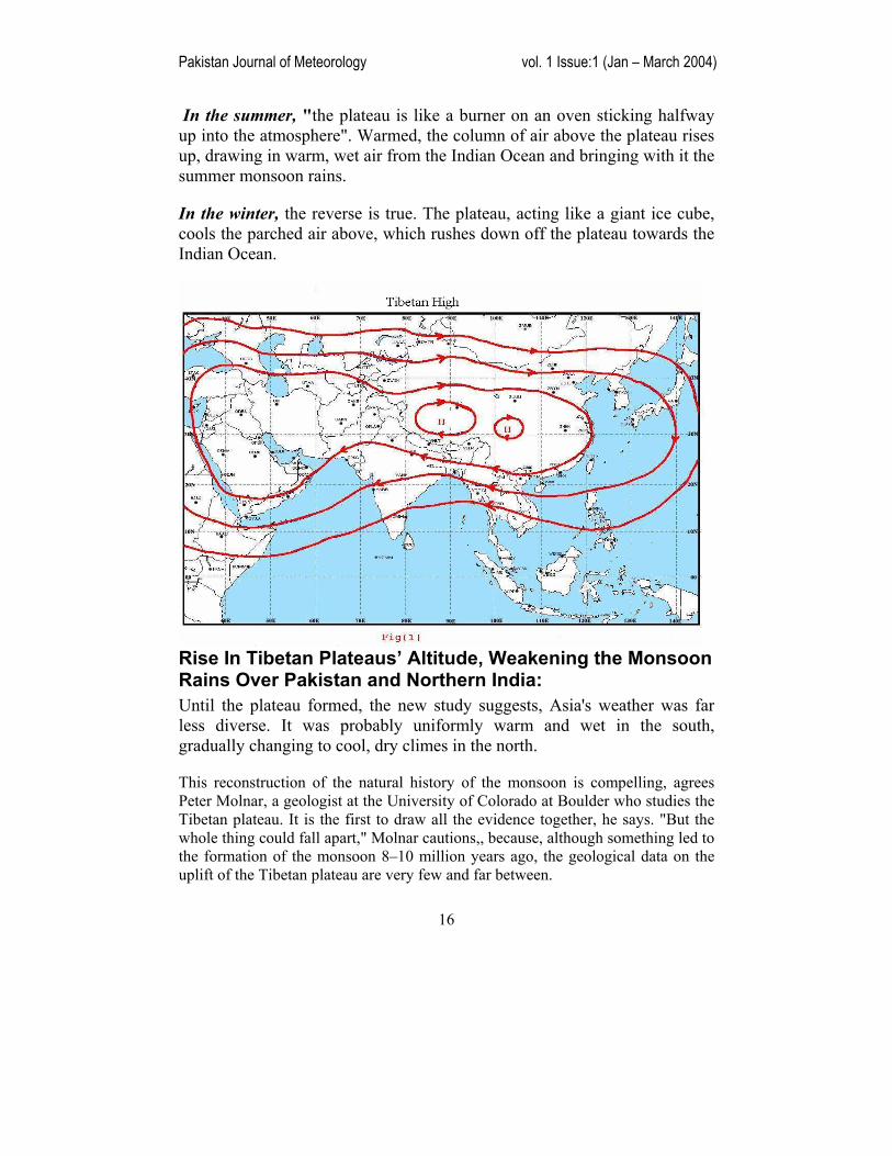
The Tibetan Plateau induced Tibetan High in the summer is therefore an important key to the summer Asian monsoon formation in Fig(1). It is well known that the strength of Tibetan High is significantly correlated with local precipitation patterns in Indian and other areas of the Asia. The exposure of the Tibetan Plateau is affected by the amount of snowfall in the winter. The size of Tibetan High determines the general area of descending and ascending, thus also the latitudinal position of the monsoon trough.
This relationship between the monsoon system (both winter and summer) and the Tibetan Plateau illustrates the scale of the monsoon and its significance in the entire dynamic system of the general circulation.
The history of the monsoon that brings life-giving rains to much of Asia in the summer, and dry, cool winds in the winter, is an uplifting one. New research links the evolution of this massive climate system with the growth of the Himalayas and the high, dry Tibetan plateau.
Today, the Tibetan plateau ringed by the Himalayas drives the monsoon winds that govern the continent's climate.
Pakistan Journal of Meteorology vol. 1 Issue:1 (Jan – March 2004)
16
In the summer, "the plateau is like a burner on an oven sticking halfway up into the atmosphere". Warmed, the column of air above the plateau rises up, drawing in warm, wet air from the Indian Ocean and bringing with it the summer monsoon rains.
In the winter, the reverse is true. The plateau, acting like a giant ice cube, cools the parched air above, which rushes down off the plateau towards the Indian Ocean.
Rise In Tibetan Plateaus’ Altitude, Weakening the Monsoon Rains Over Pakistan and Northern India: Until the plateau formed, the new study suggests, Asia's weather was far less diverse. It was probably uniformly warm and wet in the south, gradually changing to cool, dry climes in the north.
This reconstruction of the natural history of the monsoon is compelling, agrees Peter Molnar, a geologist at the University of Colorado at Boulder who studies the Tibetan plateau. It is the first to draw all the evidence together, he says. "But the whole thing could fall apart," Molnar cautions,, because, although something led to the formation of the monsoon 8–10 million years ago, the geological data on the uplift of the Tibetan plateau are very few and far between.
Pakistan Journal of Meteorology vol. 1 Issue:1 (Jan – March 2004)
17
There are models of tectonic movement to account for the plateau's rise. But the only hard geological evidence for exact phases of its growth "is based on dating just one fault", says Molnar.
Tibet as a whole inferred to have risen significantly above its current altitude (~ 5000 m).(Review GEOLOGY Science vol 294 23 November 2001)
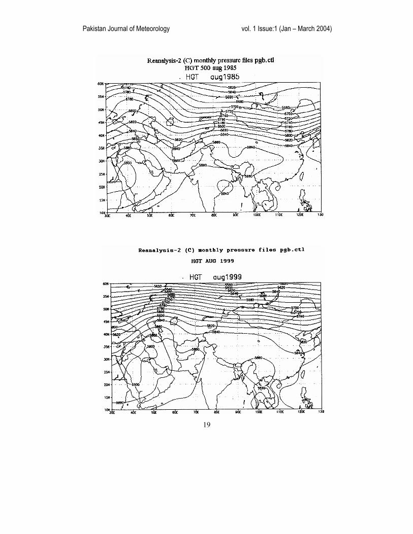
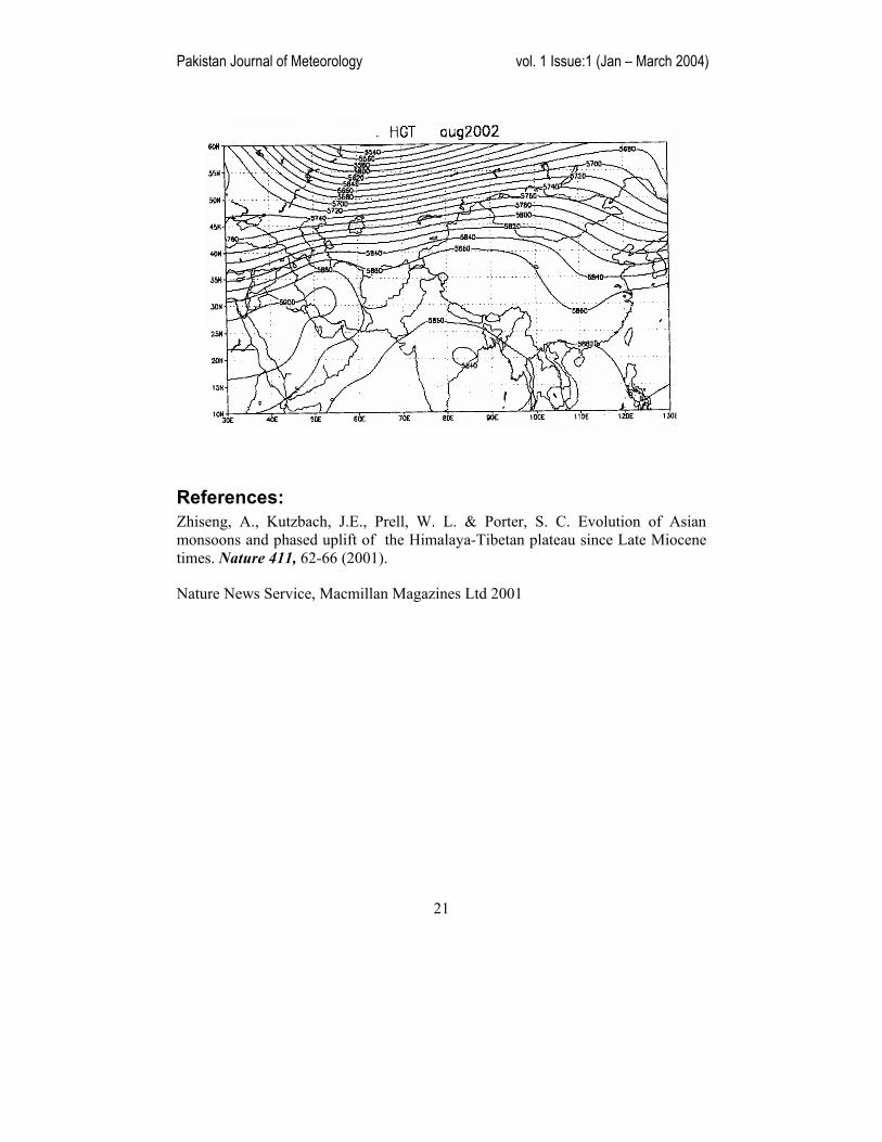
It has been observed that Tibetan High which usually formed from the past, during summer Monsoon Season has become less marked at 500 hPa. Periphery of this High is not reaching to Pakistan areas through Northern India. Therefore, the monsoon depressions formed in the Bay of Bengal usually do not move continuously to westwards due to unavailability of steering effect of Tibetan High. Penetration of low level moist easterly current along the foot of Himalayas into
upper parts of the country especially, in North-East Punjab has weakened also.
See monthly height charts of 500 hPa for the years,1984,1985 when Tibetan High was marked and received good Monsoon Rains Where as, the height charts for the years 1999,2000,2001 and 2002, when Tibetan High was less marked and Indo-Pak region experienced less Monsoon Rains.
What could have been the reason of such change in the weakening of Monsoon Rains from the past? Probably, this change in the Tibetan Plateaus’ growth, the
Pakistan Journal of Meteorology vol. 1 Issue:1 (Jan – March 2004)
18
Tibetan High (warm high) forming in somewhat more height and not drawing sufficient warm moist air from Indian Ocean, playing a part in weakening the “Monsoon Rains”
The researchers checked their interpretation by feeding the Tibetan plateau's growth into a climate model of the monsoon. Working back from the present day, they found that the monsoon weakened in a similar way to that implied by the sediment data. "It goes away as you take the mountains away," says Kutzbach.
Researchers agree with the Tibetan Plateaus’ growth that the geological data is limited, largely because so little research is done in the Tibetan plateau. But we believe that, because there is no compelling evidence for another mechanism for the monsoon's evolution, researchers work will stand the test of time. "There are differences in the details, "but the idea is rock solid."
Pakistan Journal of Meteorology vol. 1 Issue:1 (Jan – March 2004)
19
Pakistan Journal of Meteorology vol. 1 Issue:1 (Jan – March 2004)
20
Pakistan Journal of Meteorology vol. 1 Issue:1 (Jan – March 2004)
21
References: Zhiseng, A., Kutzbach, J.E., Prell, W. L. & Porter, S. C. Evolution of Asian monsoons and phased uplift of the Himalaya-Tibetan plateau since Late Miocene times. Nature 411, 62-66 (2001).