The NSGIC Distinguished Service Award recognizes exemplary service that exceeds the normal expectation of duty and that has occurred over an extended period of time. Criteria for nominations for the Distinguished Service Award include actions that: benefit more than just the nominee’s own agency or organization; demonstrate measurable improvements in implementing the NSDI; provide leadership that benefits the nation, and; work as a champion for all stakeholder groups. Contact: [email protected]Geospatial Modernization Blueprint Update Overview The Geospatial Modernization Blueprint is being created through a planning process that defines how geospatial National States Geographic Information Council (NSGIC) honors Ivan DeLoatch of the Federal Geographic Data Committee (FGDC) On March 28, 2007, the NSGIC Board of Directors presented its Distinguished Service Award to Ivan DeLoatch, Staff Director of the Federal Geographic Data Committee (FGDC). The award recognizes an individual or organization who has demonstrated leadership in advancing the National Spatial Data Infrastructure (NSDI) by promoting NSGIC’s goal of efficient and effective government through prudent implementation of geospatial technologies. Mr. DeLoatch was cited for his work with the FGDC pertaining to the Geospatial Line of Business, one of the President’s E-Government initiatives. 2007 Summer Edition Tony Spicci NSGIC Past President, Ivan Deloatch FGDC Staff Director, Stu Davis NSGIC President data and technology will be used to enhance the business activities of the Department of the Interior (DOI) in support of its mission and goals. All the DOI bureaus are participating in this process to ensure that their missions and goals will also be supported. Why is a Blueprint needed? The Geospatial Blueprint describes a recommended path to a target future state and milestones for measuring performance. It meets DOI strategic, business and technical requirements by improving cost management, business practices, investment planning and decision making. Geospatial data and technology are strategic, national assets involving major investments.
Transcript
�
The NSGIC Distinguished Service Award recognizes exemplary service that exceeds the normal expectation of duty and that has occurred over an extended period of time. Criteria for nominations for the Distinguished Service Award include actions that: benefit more than just the nominee’s own agency or organization; demonstrate measurable improvements in implementing the NSDI; provide leadership that benefits the nation, and; work as a champion for all stakeholder groups. Contact: [email protected]
Geospatial Modernization Blueprint UpdateOverview
The Geospatial Modernization Blueprint is being created through a planning process that defines how geospatial
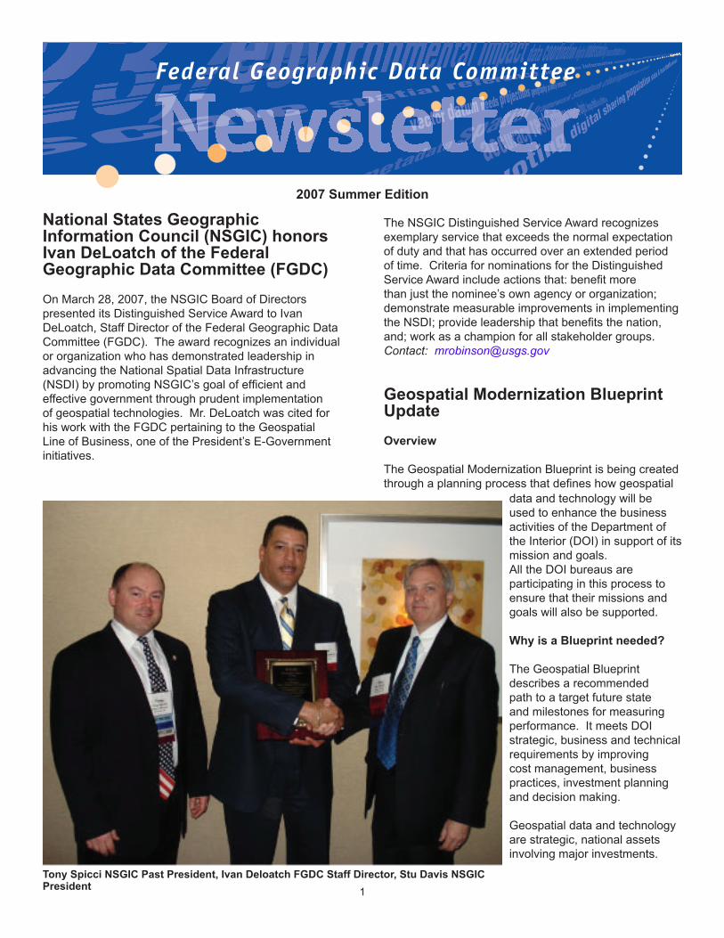
National States Geographic Information Council (NSGIC) honors Ivan DeLoatch of the Federal Geographic Data Committee (FGDC)On March 28, 2007, the NSGIC Board of Directors presented its Distinguished Service Award to Ivan DeLoatch, Staff Director of the Federal Geographic Data Committee (FGDC). The award recognizes an individual or organization who has demonstrated leadership in advancing the National Spatial Data Infrastructure (NSDI) by promoting NSGIC’s goal of efficient and effective government through prudent implementation of geospatial technologies. Mr. DeLoatch was cited for his work with the FGDC pertaining to the Geospatial Line of Business, one of the President’s E-Government initiatives.
2007 Summer Edition
Tony Spicci NSGIC Past President, Ivan Deloatch FGDC Staff Director, Stu Davis NSGIC President
data and technology will be used to enhance the business activities of the Department of the Interior (DOI) in support of its mission and goals.All the DOI bureaus are participating in this process to ensure that their missions and goals will also be supported.
Why is a Blueprint needed?
The Geospatial Blueprint describes a recommended path to a target future state and milestones for measuring performance. It meets DOI strategic, business and technical requirements by improving cost management, business practices, investment planning and decision making.
Geospatial data and technology are strategic, national assets involving major investments.
While geospatial capabilities have been implemented across all bureaus of DOI, these capabilities have not been documented and implemented in systematic ways, leading to breaks in potential interoperability and lost potential for cost savings.
The Federal and DOI Enterprise Architectures are the overarching guides for the Blueprint the process. The Geospatial Blueprint is harmonized with the OMB Geospatial Line of Business and the Geospatial Enterprise Architecture profile. All efforts are guided by the same principles: compliance with national policies and with all relevant national and international standards; business driven, not technology driven with emphasis on common solutions.
Blueprint Status
Expert planning and skilled implementation of the recommended strategies will maximize DOI’s return on investment in geospatial data, information and services. Providing nationally consistent authoritative data will greatly improve internal processes across all bureaus. Stakeholder surveys show that DOI bureaus are unanimous in support of the proposed investments.
Federal agencies and their data-sharing partners believe that opportunities for increasing internal effectiveness and efficiency while optimizing and creating new uses of geospatial resources for the Nation and its citizens can be achieved by architecting and investing in geospatial information and services in a well governed, coordinated and purposeful way.
These investments will be managed and delivered through trustworthy providers (commercial or federal) and create a common environment where:
• high quality and timely geospatial data and services are easy to find and use
• new sectors of government, the public and communities of interest will realize the benefits of national geospatial assets
• common mission business resource needs are quickly identified in the budget planning life-cycle to identify shared opportunities,
• long term geo-information access, delivery costs and efforts will be reduced,
• manual business processes will be facilitated and automated business processes improved,
• legacy application and system developments can be simplified or modernized,
• ongoing and future development activities will be less risky and costly,
• geospatial related investments and costs will be managed and accountable.
Short Term Recommendations
The Geospatial Blueprint team has almost completed the process and has identified these near term investments and improvement opportunities for:
• National Integrated Lands Systems: In accordance with A-16, establishment of service level agreements with BLM’s National Integrated Land System (NILS) as the department-wide land management application.
• Enterprise Requirements Management Planning: Conduct a pilot project to align annual planning cycles with department wide requirements collection and analysis saves data acquisition costs and optimizes resource utilization.
• Designate Authoritative Data Sources and Authoritative Services (ADS): Conduct a pilot for geospatial data sets for land ownership and cadastre, Work through a prioritized list to ensure availability of robust, standards-based geospatial data sets and geospatial services that meet the business needs of Interior.
• Establish data management life cycle policy and practices: This recommendation deals with the need for standard business policies, processes and services for data. These policies will be needed to ensure the creation of the Authoritative Data Sources and Services as well as the implementation of other recommendations.
• Enterprise Licensing Agreements: Development of new enterprise license agreements or consortia for geospatial software and geospatial data sources.
• Establish Program Management Office (PMO): This office would be the main contact for coordination of enterprise contracts, service level agreements for data and services and other DOI wide geospatial functions.
• Governance: Establishment of an improved geospatial governance structure to develop and manage policy, blueprint implementation, data, infrastructure and services life cycle and investment portfolio.
The Geospatial Blueprint Team
The Geospatial Modernization Blueprint is supported by Colleen Coggins, Chief Architect, DOI, and is sponsored by Karen Siderelis, National Geospatial Program Office (NGPO), U.S. Geological Survey (USGS). NGPO Project Manager is Robert Pierce.
Core Team: NGPO has assembled a Core Team of executives to represent DOI business and programs, existing investments, E-government and management accountability:
�
• Tom Weimer - DOI Assistant Secretary for Policy, Management and Budget
• Mark Limbaugh – DOI Assistant Secretary for Water and Science
• Tim Petty – DOI Deputy Assistant Secretary for Water and Science
• Linda Gundersen - USGS Acting Associate Director for Geology, E-Gov representative
• Leslie Cone – BLM NILS Project Manager• Mike Howell – USFWS CIO• Billie Clarke – OSM, Chief National Technology
Innovation and Professional Services• Mike Gabaldon - BOR, Director of Technical
Resources• Sue Hawkins – NPS, Deputy CIO, Information
Systems• Bob Brown, MMS,CIO• Debbie Clark, BIA, Deputy Assistant Secretary
(Management)
The executive and business sponsorship will be required to review and approve critical work products generated by the project. The executives will act as the project’s governance board and be referred to as the Geospatial Modernization Blueprint Core Team (CMBT). The CMBT is assisted by Subject Matter Experts known as the Enterprise Geographic Information Management Team (EGIM) as well as technical advisors and contractor support:
Subject Matter Experts/EGIM TeamBIA - Beth Wenstrom FWS - Deb GreenBLM – Bob Bewley FWS - Gary KraussBLM – George Heine MMS – Leonard CoatsBOR - Lorri Peltz-Lewis NPS – Dave DuranBOR - Bruce Whitesell NPS - Joe GregsonOSM – Rob Welsh USGS – Jennifer SieverlingOSM - Alan Wilhelm USGS – Jacque Fahsholtz For more information please contact:
26 Projects Granted 2007 CAP AwardsIn March the FGDC Secretariat was pleased to announce the recipients of this year’s NSDI Cooperative Agreements Program awards. For the five categories a total of $1,118,775 was granted. The projects began in late spring and will wrap in late spring of 2008.
Category 1: FGDC-Endorsed Standards Implementation Assistance and Outreach provides funding to organizations to assist in the implementation of FGDC-
endorsed standards. The results of this category will be materials that can provide step-by-step assistance or a roadmap for implementing FGDC-endorsed standards.
North Pacific Ecosystem Metadata Federation: China ComponentAlaska Fisheries Science Center, NOAASeattle, WA Metadata Outreach And Assistance for Northwest IndianaIndiana UniversityBloomington, IN
Propagation of FGDC-Endorsed Metadata Standards across the Great Lakes BasinRemote Sensing & Geographic Information ScienceMichigan State University East Lansing, MI
MAGIC Metadata TriageMid America Geographic Information Consortium Topeka, KS
NBII Outreach and Training Program for FGDC Content Standard for Digital Geospatial MetadataNational Biological Information InfrastructureReston, VA and Seattle, WA Handson Metadata Training for National Park Service Personnel in the New England RegionUniversity of Rhode Island Kingston, RI
Virginia Metadata Clearinghouse Implementation SupportThe Virginia Geospatial Extension ProgramBlacksburg, VA
Category 2: Framework Client Development projects will develop software clients for Framework Data Services to provide assistance to advance the development of client software to exploit online Framework Data to support general access to ANSI Framework data vector themes. Software will be integrated and provided as a capability of an existing desktop geographic information system client. An underlying goal is to increase visibility, usability, and regular access to established Framework data services.
ArcGIS Framework Plug-InGeorge Mason University Fairfax, VA
Extending uDig GIS and GeoTools Library for US Framework Data The Open Planning Project New York, NY
Category 3: Fifty States Initiative projects will develop and implement statewide strategic and business plans that will facilitate the coordination of programs, policies, technologies, and resources that enable the coordination, collection, documentation, discovery, distribution, exchange and maintenance of geospatial information in support of the NSDI and the objectives of the Fifty States Initiative Action Plan. Like the 2006 CAP awards eleven States received awards in 2007, they are California, Florida, Illinois, Indiana, Iowa, Maine, Missouri, New York, South Dakota, Utah, and Vermont.
Category 4: Geo-Enabled Federal Businesses Initiative projects goal is to effectively communicate to Federal business managers the value of incorporating geospatial approaches into business processes, especially to those who have had limited experience with geo-enabled decision-making. The GMU project will develop comprehensive business cases for geo-enabling at least ten decision-making processes that are common across Federal programs. The Great Lakes project will produce a demonstration of integrated, geo-enabled decision-making across 3 to 5 businesses that serve a common goal within a given population.
Leveraging Geospatial Resources - Making the Case for Geo-Enabling Decision Processes in the Great Lakes Great Lakes Commission Ann Arbor, MI
Improving Federal BusinessGeorge Mason UniversityFairfax, VA
Category 5: Geographic Information Integration projects will assist organizations and consortia to work together with the NGPO to develop and provide access to geospatial information that serves regional and local community needs. The deliverables for the projects include base topographic data provided to The National Map and other data available through the Geospatial One-Stop portal, operational capability to maintain and update data evidenced through periodic updates of data made available through The National Map, and a written agreement with NGPO to serve as an NSDI steward.
Iron Range GIS CollaborativeArrowhead Regional Development CommissionDuluth, MN
Information Integration and Analysis Project McIntosh County Commission, GeorgiaDarien, GA
Ohio’s Statewide Imagery Program (OSIP) Data Delivery Ohio Office of Information TechnologyColumbus, OH
Western Michigan’s Upper Peninsula Geospatial Data Outreach ProgramWestern Upper Peninsula Planning & Development RegionHoughton, MI
For more information about the 2007 NSDI CAP and other past CAP projects please see the FGDC Grants Web site, http://www.fgdc.gov/grants. As they are completed results from 2007 projects will also be posted on this site. Questions and comments can be directed to Gita Urban-Mathieux, NSDI CAP coordinator, [email protected], 703-684-5175.
Watch for the 2008 CAP Announcement
Information for the categories and schedule for the 2008 NSDI CAP announcement will be made available by late summer 2007. The planned opening date for proposal submissions is late October 2007. Check the FGDC Grants Web site, http://www.fgdc.gov/grants.
National Spatial Data Infrastructure Cooperative Agreements ProgramFor 12 years, the FGDC has used the Cooperative Agreements Program (CAP) to help the geospatial data community implement components of the NSDI. CAP – which is open to federal, state, local and Tribal governments, as well as academia and commercial and non-profit organizations – has provided small seed grants to initiate sustainable, on-going NSDI implementation. The program emphasizes partnerships, collaboration, and the leveraging of geospatial resources for achieving its goals.
CAP awards have played a substantial role in promoting and disseminating the tenets of the NSDI to thousands of practitioners. To date, the NSDI CAP awards have created collaborations at all levels of government, developed an understanding of geospatial information in organizations and disciplines new to the NSDI, provided seed money to enable geospatial organizations to participate in the national effort to implement the NSDI, promoted the development of standardized metadata in hundreds of organizations, and funded numerous implementations of OGC Web Mapping Services and Web Feature Services.
• Three Train the Trainer Workshops conducted by grant recipients: USGS’s National Biological Information Infrastructure (NBII), the NOAA Coastal Services Center, and the Center for International Earth Science Information Network (CEISIN) at Columbia University. In all, 34 metadata trainers were prepared to train larger groups.
• Creation of training opportunities for more than 330 people within city, county and Tribal government entities – including public health and emergency response organizations – by the NBII, the Merriam Powell Research Center at the University at Northern Arizona, the University of Idaho, the University of Indiana, Columbia University and the government of Westchester County, NY.
• Saving more than $8.5 million in staff time through the Minnesota Geographic Data Clearinghouse.
• Configuration and deployment of Web Feature Services (WFS) by Vermont, Rhode Island, Minnesota, North Carolina, and the Center for International Earth Science Information Network (Columbia University) to support NSDI Framework themes, including Governmental Units, Hydrography, and Transportation.
• Providing seed funding to Wisconsin to promote the advantages of a shared spatial infrastructure within that state.
• Helping the Tennessee Valley Authority provide access to its Aerial Photography Index via an OGC Web Map Service.
• Supporting South Carolina’s establishment of a user-friendly geospatial portal that is an outstanding return on investment.
• Helping the California Geographic Information Association bring together national, state, regional and local organizations to draft a comprehensive regionally-relevant, nationally consistent framework data plan. This provides the foundation for a California GIS Council data plan and will be used to promote the FGDC’s “Fifty States Initiative”.
• Under the leadership of the Wisconsin Department of Natural Resources, completion of 11 high- resolution hydrologic units, which were added to the National Hydrology Database.
• Helping the University of Oklahoma incorporate local data into the development of high-quality street centerline data.
For the 2006 CAP, there were 25 ongoing projects. The budget for the year was $1.2 million, funding projects in five areas:
• The Fifty States Initiative, designed to accelerate statewide coordination activities that advance the National Spatial Data Infrastructure.
• Projects that enable organizations with NSDI expertise, knowledge and experience to assist other organizations with the training and implementation of metadata, clearinghouse, and/or web mapping services.
• Framework Client Development projects that are developing software clients for Framework Data Services. These services will exploit online Framework Data to support operational needs of an application community.
• Through joint funding by GeoConnections Canada and FGDC, a Spatial Data Infrastructure project that will map the spread of infectious diseases across the Maine/New Brunswick Border.
• Projects that are developing sustainable partnerships to integrate, maintain and provide access to current geospatial data and to develop the infrastructure needed to integrate these data and make them available through geospatial programs of the NGPO.
Over the years, the desired CAP outcomes have been modified to meet evolving NSDI requirements. For 2007, CAP is refocusing some projects, as follows:
• Awards still will be given to projects under the Fifty States Initiative, and for framework client development, and for geographic data integration.
• The metadata trainer and outreach assistance category has been expanded to include all FGDC-endorsed standards.
• To support the Geospatial Line of Business, a new category was added. The goal of the new Geo-Enabled Federal Businesses Initiative is to communicate the value of incorporating geospatial approaches into business processes to Federal business managers.
The 2007 budget of $1.2 million will fund up to 26 projects. The announcement of the 2007 awards was made in March of 2007.
For more information about the CAP see http://www.fgdc.gov/grants.
Updates on the FGDC Steering Committee and Coordination Group Meetings The FGDC Coordination Group is comprised of chairpersons of the thematic Subcommittees and ‘cross-cut’ Working Groups, and representatives from Federal agencies and FGDC recognized stakeholder groups. The Coordination Group meets once a month in the Washington, DC area. Areas of focus at recent meetings
have included the FGDC Annual Report, the Geospatial Line of Business, and the creation of a National Geospatial Advisory Committee. For information about the FGDC Coordination Group charter, membership and meeting minutes please visit: http://www.fgdc.gov/participation/coordination-group
The Federal Geographic Data Committee (FGDC) Steering Committee is chaired by Lynn Scarlett, the Deputy Secretary of the Interior and Karen Evans, the Office of Management and Budget administrator for e-government and IT. The Steering Committee is the policy-level interagency group responsible for overseeing Office of Management and Budget (OMB) Circular A-16 related activities and implementation of the National Spatial Data Infrastructure (NSDI). The Steering Committee’s central focus is to provide the executive leadership for the coordination of federal geospatial activities between, among, and within agencies by establishing policy and providing guidance and direction to the member agencies. The committee meets four times a year and has focused this year on the implementation of the Geospatial Line of Business and the creation of a National Geospatial Advisory Committee. For more information, please visit: http://www.fgdc.gov/participation/steering-committee
Spatially Speaking: Geospatial Line of BusinessThe Geospatial LoB has set forth ambitious and transformational goals to better serve the Nation’s interests. Building on the policy foundation of the Office of Management and Budget (OMB) Circular A-16 (“Coordination of Geographic Information and Related Spatial Data Activities”) and the President’s Management Agenda, the Geospatial LoB is establishing a new and more citizen-centric collaborative model for geospatial-related activities and investments. This will
create a framework for sustainable participation from non-Federal partners, and create a more coordinated and leveraged approach to producing, maintaining, and using geospatial data and services. OMB and the Geospatial LoB are focused on business-driven, common solutions(s) aligned with the Federal Enterprise Architecture (FEA) and guided by the FEA Geospatial Profile and the National Spatial Data Infrastructure (NSDI) in order to support operations across the Nation and beyond. The common solution consists of three solution tracks. Each solution track plays a critical role in supporting the vision, goals, and objectives of the Geospatial LoB.
Solution Tracks• Enhanced Governance• Planning and Investment Strategy • Optimize and Standardize Geospatial Data and
Services
The first step for improving business processes require that we understand our business. There are a number of data calls underway which will assist in getting the understanding, supporting and developing the geospatial information business case, and setting the goals for the future for geospatial information. The inter-agency task force members are working with the Senior Agency Official for Geospatial Information (SAOGI) for their organization in order to respond to the following data calls:
• Geospatial Agency Investment Reporting ~ a quantitative designed to assess agency investments in geo-spatial related activities and capabilities (due April 27, 2007)
• Geospatial Data and Services Priorities Survey ~ this qualitative survey is designed to understand better agency business activities and how agencies use select OMB Circular A-16 data to meet business/mission requirements as opposed to focusing on the “numbers.” (due May 15, 2007)
• National Data Infrastructure Data Themes A-16 ~ agency performance reporting information with regard to national coverage coordination and stewardship of NSDI data themes as required by the revised OMB Circular A-16 (due May 25, 2007)
As the Geo LoB matures and business processes improve, geospatial information will be readily available and accessible to all. Geo LoB highlights include:
• Global Spatial Data Infrastructure (GSDI) Small Grants to be awarded for 2006 and 2007 received 85 responses to the call for proposals. The FGDC supports the GSDI in many areas, including contributing to the Small Grants program designed Geospatial Information helps you know where your business is
to encourage SDI development globally-- particularly in nations with developing economies and emerging SDIs. A formal announcement of the awards will occur in June 2007. For more information contact Al Stevens ([email protected]).
• The Open Geospatial Consortium, Inc. (OGC) has issued a Call for Participation (CFP) in the “Architecture Implementation Pilot,” which is a co-ordinated interoperability initiative of Group on Earth Observation System of Systems (GEOSS), Federated Earth Observation Pilot (FedEO) and Tri-Lateral initiatives (US, Canada, and European SDIs). Responses are due by May 11, 2007. The Architecture Implementation Pilot CFP documents can be downloaded from: http://portal.opengeospatial.org/files/?artifact_id=2095�. For more information contact Doug Nebert ([email protected]).
• Metadata trainers conducted two workshops and a Train-the-Trainer workshop in Texas. The workshops were held based on request from Texas A & M’s Coastal Studies Department, NOAA Coastal Data Development Center, and Texas Department of Information Resources. For more information contact Sharon Shin ([email protected]).
• The Library of Congress (LOC) and the FGDC met to discuss the FGDC and the Loch’s National Digital Information Infrastructure and Preser-vation Program (NDIIP). Geospatial is one of the significant digital content types that LOC has interest in preserving. They currently have two geospatial cooperative partnerships and are looking to develop additional state based programs for geospatial digital data preservation. For more information contact Milo Robinson ([email protected]).
• The draft Wetlands Mapping Standard has been released for a 30-day review by the FGDC Standards Working Group. For more information contact Julie Maitra ([email protected]).
• Springer Science + Business Media has accepted articles that define and explain the organizational initiatives “National Spatial Data Infra-structure” and “Federal Geographic Data Committee” for inclusion in the Encyclopedia of GIS. This encyclopedia is designed to be an authoritative source for definitions and concepts in the geospatial sciences field. It is expected to be released in January 2008. For more information about the Encyclopedia of GIS, visit: http://ww.springer.com/west/home/generics/search/results?SGWD=4-40109-22-173664907-0.
The Common Solutions Team UpdateThe Common Solutions team from the Geospatial Line of Business convened two seminars on April 11, 2007 at the FAA Headquarters in Washington to help executives and business architects becomes aware of geospatial concepts in order to better align agency enterprise architectures. The first seminar was for Chief Information Officers, Chief Technology Officers, and senior managers who are responsible for integrating agency data requirements. The second seminar was designed for agency business architects who are responsible for enabling geospatial capabilities into agency enterprise architectures. The seminars were well attended with over 60 participants and excellent presentations. These have been packaged and posted on the FGDC website under the Geospatial Line of Business page. For more information contact Barry Davis, [email protected], and Doug Nebert, [email protected].
Challenge – The Forest Service needed to improve its ability to provide tactical geospatial wildland fire products for the 2006 fire season.
Action – Enhancements were made to the Phoenix airborne thermal infrared fire detection system. It now provides digital geo-corrected imagery to emergency fire personnel.
Result – This significant enhancement over the previous analog products has resulted in significant savings in time for the production of fire perimeter, active fire front, and hot spot mapping. See http://nirops.fs.fed.us/ for more information.
Challenge - Need for population data for pre- and post- disaster hurricane affected areas
Action – US Census Bureau created two special products for areas affected by Hurricanes Katrina and Rita. The first was population estimates by county before the event (July 2004 and July 2005) and after the hurricane (January 2006). In the second product, data from The American Community Survey shows population and housing characteristics for before and after the disaster.
Result – Access to population information for both pre- and post-Katrina for planning and recovery.
Challenge - Delivering post-hurricane and tropical storm aerial imagery to the public as soon as possible.
Action - In coordination with federal partners and state and local governments, NOAA began damage assessment flights following Hurricanes Rita’s and Wilma’s landfall.
Result - Public access to the images aided emergency response and allowed assessment of damages. Increasingly used for insurance assessments, for example, thus allowing meaningful savings in personnel time and money.
Current ImageryChallenge - Increase Partnerships to Maximize LeverageThe Department of Homeland Security’s (DHS’s) Geospatial Management Office (GMO) has made a significant investment in the acquisition of imagery to support programs for development of geospatial data to support disaster preparedness and homeland security. Federal contributions continues to make significant progress in the ongoing challenge of coordinating, communicating, documenting, and reporting existing and proposed geospatial data to meet the ongoing goals for the development of the National Spatial Data Infrastructure (NSDI).
Action - Decided to increase use of federal, state and local partnership opportunities. DHS recognized the need for improved access to geospatial data in the aftermath of hurricane Katrina and formed a highly
successful partnership with USGS and NGA to fund imagery programs that would exercise maximum leverage to support an array of federal, state, local and tribal needs. The partnership enables federal agencies to take advantage of USGS’ state liaisons who are responsible to identify imagery programs at the State/local level where federal funds could act as a catalyst to enable the program to proceed or to expand the planned area of coverage. In addition to funding state and local programs, NGA and DHS provided a pool of funds to USGS to complete the orthophoto coverage of the 133 Urban Area initiative. The partners requested that all data sets were to be fully documented with metadata that complies with requirements of the Federal Geographic Data Committee. Completed orthophotography will be published on the USGS seamless data server and on the Hazards Data Distribution System (HDDS).
Result - 16:1 ROI. As a result of this partnership DHS leveraged a total of approximately $70,000,000.00 in current orthophotography based on an investment of approximately $4,400,000.00. This data is sharable with federal, state and local agencies and provides comprehensive, current preevent coverage for those areas of the Gulf of Mexico and the Southeastern Atlantic coasts that are at greatest risk for damage by hurricanes and storms.
The homeland security community and local stakeholders derive significant benefit from the high resolution coverage that is produced to support the ��� Urban Areas initiative, this coverage is critical in the development of inventories of critical assets and key resources surrounding major US urban centers.
Challenge - After Hurricane Katrina (later followed by Hurricanes Rita and Wilma), HUD’s Office of Policy Development and Research (PDR) responded to information requests by senior policy officials and an interagency taskforce on the magnitude of the disasters in terms of both the overall housing stock and the HUD Insured and Assisted housing stock. This was followed by a request to provide a detailed analysis of how the storms affected the New Orleans metropolitan area specifically and offer some thoughts on what major issues would affect its long-term recovery. Finally, after Congress appropriated $11.5 billion in December 2005 for the Community Development Block Grant (CDBG) program to support long-term recovery, PDR was tasked with obtaining the data to develop an allocation formula to divide funds between Alabama, Florida, Louisiana, Mississippi, and Texas. After a second supplemental
appropriation of CDBG funds in June 2006 of $5.2 billion, PDR was again asked to provide data to the Secretary of HUD to assist with dividing those funds among the five affected states.
Action - For all of these activities, PDR made extensive use of Geographic Information Systems (GIS). To identify HUD insured and assisted properties in the damage areas, as well as to examine demographic characteristics of households in the most affected areas from the storms, HUD overlayed the FEMA IT Mapping and Analysis Center (MAC) “remote sensing” damage areas on Census 2000 block and block group data as well as the latitude and longitude of HUD’s properties. HUD also overlayed a flood depth GRID file from NOAA, representing the depth of the floodwaters on August 31 for Orleans and St. Bernard Parish, on the Census 2000 block data and HUD administrative records to show how many units were likely in areas of deep flooding versus shallow flooding. Finally, HUD obtained from FEMA and SBA data on housing inspections completed for FEMA’s Individual Assistance program and SBA’s disaster grant program. HUD geocoded the data and used those geocodes, particularly the United States Postal Service Delivery Point Bar Code, to identify individual housing units when the unit had multiple registrants. Included with the inspection data was information about the type of damage (wind or flood), tenure, insurance status, and income. HUD also determined if the units that experienced flooding were inside or outside a flood zone by performing an overlay operation known as a spatial join with the geocoded FEMA-registered housing units and the FEMA Q3 flood coverage. All of these data allowed HUD to create cross tabs on household and housing characteristics by extent and type of damage.
Result - PDR developed several papers for senior policymakers and Congressional staff describing the extent of housing damage in each community and who was most affected. The data were also used to make decisions about how to allocate $16.7 billion in supplemental CDBG funds to facilitate long-term recovery.
Challenge - Provide cadastral data and contacts in support of wildland fire and hurricane events.
Action - Completed inventories or cadastral data and contacts in priority counties in the west and for areas along the Gulf Coast. Cadastral data profiles defining the information that is needed in support of these initiatives have also been developed and distributed to support the publication of cadastral data. In addition,
BLM assisted the wildland fire efforts in the west to obtain cadastral data (primarily from county assessor data bases) in support of fire response teams and economic analysis to determine “values at risk.” Cadastral data was obtained for all fires where it was available with the exception of one county which was unwilling to provide the data.
Result - Wildland fire applications were successfully supported by conducting economic analyses of values at risk in comparison to expenditures for responding to wildland fires. Fire personnel were also given information that helped establish priorities based upon information in regards to life (residences), structures and the value of real property.
Challenge - (Contributed by Deidre McCarthy, NPS Cultural Resource GIS Program)As a result of the damage caused by Hurricane Katrina, the National Park Service Cultural Resource GIS Facility was asked to develop and implement an historic preservation data management system for New Orleans and the seven surrounding Parishes. This system was to be developed in consultation with the Louisiana State Historic Preservation Office and the New Orleans Historic District Landmark Commission to meet FEMA’s legal requirements under Section 106 of the National Historic Preservation Act. These requirements call for the identification and evaluation of all potential Federal undertakings for their eligibility to the National Register, and the definition of treatment measures that FEMA should carry out to mitigate against the anticipated adverse affects on those historic resources.
Action - The National Park Service Cultural Resource GIS Facility developed a strategy to survey and evaluate the properties slated for demolition by the Parishes using GPS, with detailed data dictionaries to document the historic characteristics, condition, integrity and National Register eligibility of each structure. This data was incorporated into a GeoDatabase designed by the Cultural Resource GIS Facility, implementing the draft cultural resource spatial data standards mandated by OMB Circular A-16.
Result - Having extremely detailed locational information incorporated into a GIS serves as a form of documentation acceptable under Section 106 of the National Historic Preservation Act for the first time. The ability to use GIS to coordinate among FEMA, the Louisiana State Historic Preservation Office and other agencies brought the review time for each potential Federal undertaking down from 90 days to approximately
2 weeks, helping to speed the recovery in the area. Further, the GPS survey strategy is being implemented as a treatment measure under Section 106 for the first time with FEMA surveying National Register historic districts throughout New Orleans for their inclusion in the GeoDatabase. As a result, the draft cultural resource spatial data standards created by the National Park Service have proven to be extremely useful in their implementation across the disaster area. FEMA and the Department of Interior have entered into an interagency agreement to provide continued support for this effort in the Gulf Coast and other areas.
Challenge - Provide Wetlands Geospatial Data for Bird Flu Emergency Preparedness. In May 2006, the U.S. Fish and Wildlife Service responded to a request from the Center for Disease Control and the U.S. Department of Agriculture’s Centers for Epidemiology and Animal Health (APHIS) related to avian influenza (Bird Flu). Because of the human health threats posed by potential pandemic, infectious disease specialists wanted to develop a model to assess the threat level based on transmission of avian influenza virus spread through wild populations of migratory waterfowl or water birds. To conduct these analyses, disease specialists needed to know where and how many wetlands and surface water bodies might serve as staging areas for migrating birds. They requested the Service’s assistance in acquiring digital wetlands data from the Service’s Wetlands Geodatabase.
Action - The Service accessed and provided its entire wetlands digital dataset for the conterminous United States (40+ gigabytes) for the avian influenza study on May 30, 2006. This involved coordination with APHIS specialists to provide large amounts of digital wetlands data in proper format and development of a grid system to partition the data and make determinations of the size and location of water bodies and wetlands that would support migratory birds. This was done on very short turn-around to meet the timeline requirements for this emergency preparedness study.
Result - APHIS planned to use this information to develop models of areas susceptible to avian influenza outbreaks should migratory bird populations become infected. This may have consequences for the deployment of emergency response medical teams and supplies should large numbers of birds become infected along migratory routes in close proximity to human population centers. While this event has not occurred to date, the emergency preparedness planning that used the wetlands data may someday help save human lives.
Challenge - Personnel in TVA’s Transmission Emergency Operations Center (TEOC) needed a means to quickly view transmission assets (structures, lines, and substations) and distributor customers affected by hurricanes, tornados, ice storms and other disasters.
Action - TVA developed a GIS approach, drawing data from the Power System Operations work management system and the incident data base, to enable TEOC staff to rapidly display the location of affected assets and customers and to track / guide system operations throughout an emergency incident.
Result - The Affected Assets and Customers Tracking System was developed following Hurricane Katrina. It has already been used in response to several tornado outbreaks in the TVA Power Service Area during 2006.
Partner agencies utilize NASA’s research data for input into decision support tools (DST’s) developed by our operational and/or partner agencies. Two research projects directly relate to emergency response and preparedness success stories:
1. The Modeling, Analysis Prediction (MAP) 06 Project, http://map06.gsfc.nasa.gov/, so named for its affiliation with NASA’s Modeling, Analysis, and Prediction (MAP) program, will apply NASA’s advanced satellite remote sensing technologies and earth system modeling capabilities to improve our understanding of tropical cyclones that develop in and move across the Atlantic basin.
2. The MODIS Rapid Response system, http://rapidfire.sci.gsfc.nasa.gov/, has been developed to provide rapid access to MODIS data globally, with initial emphasis on 250m color composite imagery and active fire data. The experience gained during the Montana fires of 2000,
when the MODIS team was asked to provide active fire information to the U.S. Forest Service (USFS), has led to the improvement and automation of several of the steps involved in MODIS rapid data provision. Imagery and data are now being provided to a number of users such as the USFS Remote Sensing Applications Center (RSAC), the National Interagency Fire Center (NIFC), the U.N. Global Fire Monitoring Center, and NASA’s Earth Observatory.
Action - Developed an enterprise-wide asset tracking system called ‘Map Tracker’
Result - The ‘Map Tracker’ greatly improved the management of the map production process. EPA staff are integrating geospatial metadata into the tool to provide the metadata along with the maps. This Enterprise Tool is slated to be available across the enterprise for emergency response actions in the spring of 2007.
NGA – Norman C. Andersen, [email protected], 703-814-4565The Geospatial Intelligence (GEOINT) Standards Working Group (GWG) is a working group under the Department of Defense’s Information Technology (IT) Standards Committee (ITSC). The GWG provides a standards-focused forum for the GEOINT community to review, develop, coordinate, and recommend studies, reports, and Department of Defense (DoD) and Intelligence Community (IC) positions in the areas of GEOINT standardization activities and, as appropriate, recommend adoption of GEOINT standards to the DoD IT Standards Registry (DISR). The GWG operates as a consensus-based community forum and will adhere to a set of operating principles in the conduct of all business and the fulfillment of responsibilities assigned by the GWG Charter.
The GWG has the following objectives:• Provide a management structure and process to
evolve and maintain GEOINT standards using the DISRonline tool,
• Respond to the needs of the NSG GEOINT community, and
• Support the ITSC objective to maximize, through
use of the DISRonline, the Change Request (CR) process and the use of electronic distribution and coordination, to include web-centric services to reduce the requirements for face-to-face meetings.
The GWG currently has eight focus groups; The Metadata Focus Group is one. The Metadata Focus Group (MFG) deals with those aspects of the standardization of GEOINT relating to imagery, sensor and geospatial metadata. Metadata is used by a large population of users other than the producer of the metadata. Usually, it is created by someone and used by someone else. Standardizing the structure and use of metadata will provide creators with appropriate information to characterize the data. Furthermore, standardizing the use of metadata will enable users to effectively implement the metadata to facilitate the most efficient method to discover and retrieve the associated data.
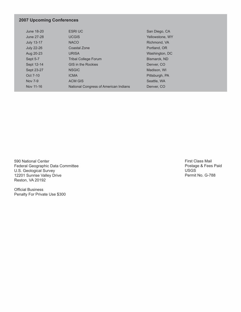
June 18-20 ESRI UC San Diego, CA June 27-28 UCGIS Yellowstone, WY July 13-17 NACO Richmond, VA July 22-26 Coastal Zone Portland, OR Aug 20-23 URISA Washington, DC Sept 5-7 Tribal College Forum Bismarck, ND Sept 12-14 GIS in the Rockies Denver, CO Sept 23-27 NSGIC Madison, WI Oct 7-10 ICMA Pittsburgh, PA Nov 7-9 ACM GIS Seattle, WA Nov 11-16 National Congress of American Indians Denver, CO
590 National CenterFederal Geographic Data CommitteeU.S. Geological Survey12201 Sunrise Valley DriveReston, VA 20192
Official BusinessPenalty For Private Use $300
First Class MailPostage & Fees PaidUSGSPermit No. G-788