2008 Intensive Observation Period in Arid/Semi-arid China— MAIRS Contribution to AMY Ailikun, Congbin FU International Program Office of MAIRS Chinese Academy of Sciences 3 rd AMY workshop, 26-27 Jan 2008, Yokohama, Japan
Transcript
2008 Intensive Observation Period in Arid/Semi-arid China—MAIRS
Contribution to AMY
Ailikun, Congbin FUInternational Program Office of MAIRS
Chinese Academy of Sciences
3rd AMY workshop, 26-27 Jan 2008, Yokohama, Japan
Importance of Dryland Study
Water resources and ecosystem service goods are crucial to the people living in dryland regions
Dryland regions are sensitive to climate variation and human perturbations
Dryland areas in monsoon Asia are the major sources of dust aerosol
Land degradation in
semi-arid China
Desertification speed over northern China (Cai, 2005)
Before mid 1970’s: 0.15 million hec/y
mid 1970’s to 1980’s: 0.21 million hec/y
After 1990’s: 0.25 million hec/y
The difficulties for dryland study
Complicated topography and landscape.
Bad simulation in both GCM and RCM
Lack of high resolution observation data
The mechanism of water balance and water cycle are not clear
Field observing stations are running by various institutes and organizations, no data sharing or exchanging system
Observing Stations over dryland China
Developing of Multi-discipline Observing Network over Arid/semi-arid China—Participants
Universities (2)Universities (2) : Lanzhou University, Beijing Normal Univ : Lanzhou University, Beijing Normal Universityersity•CAS (6)(6)—Institute of Atmospheric Physics/IAP, Cold and Cold and Arid Regions Environmental and Engineering Research InArid Regions Environmental and Engineering Research Institute/CAREERI, Institute of Geographic Sciences and Natstitute/CAREERI, Institute of Geographic Sciences and Natural Resources research/IGSNRR, Institute of Soil and Watural Resources research/IGSNRR, Institute of Soil and Water Conservation, Institute of Botany, Xinjiang Institute of er Conservation, Institute of Botany, Xinjiang Institute of Ecology and Geography;Ecology and Geography;• Chinese Meteorological Administration(7)Chinese Meteorological Administration(7)—Gansu Bure—Gansu Bureau, Xinjiang Bureau, Shanxi Bureau, Ningxia Bureau, Shanau, Xinjiang Bureau, Shanxi Bureau, Ningxia Bureau, Shannxi Bureau, Jilin Bureau, Inner Mongolia Bureau. nxi Bureau, Jilin Bureau, Inner Mongolia Bureau.
Developing of Multi-discipline Observing Network over Arid/semi-arid China—workshops
1st national workshop on integrated dryland study
27-29th Jun, 2007
Beijing
2nd National workshop on integrated dryland study
10th Dec, 2007
Beijing
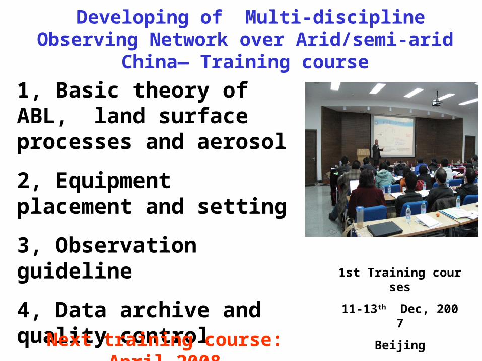
Developing of Multi-discipline Observing Network over Arid/semi-arid China— Training course
1st Training courses
11-13th Dec, 2007
Beijing
1, Basic theory of ABL, land surface processes and aerosol
2, Equipment placement and setting
3, Observation guideline
4, Data archive and quality control
Next training course: April 2008
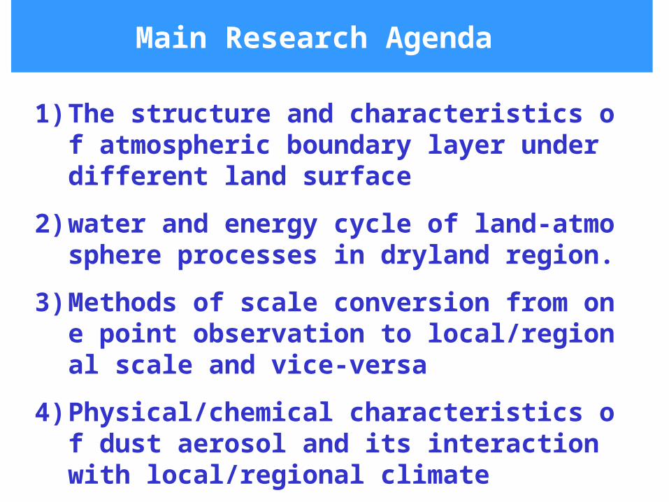
Main Research Agenda
1) The structure and characteristics of atmospheric boundary layer under different land surface
2) water and energy cycle of land-atmosphere processes in dryland region.
3) Methods of scale conversion from one point observation to local/regional scale and vice-versa
4) Physical/chemical characteristics of dust aerosol and its interaction with local/regional climate
Main Observing Agenda
1)Atmosphere boundary Layer
2)Land surface processes
3)Dust Aerosol
4)Ecosystem
70°E 80°E 90°E 100°E 110°E 120°E 130°E 140°E30°N
35°N
40°N
45°N
50°N
55°N
1
2
3
4
5
6
7
8
9
10
11
12
1314
1516
Map of Multi-discipline Observing Network in Arid/Semi-arid China (20 stations)
Ground meteorology and radiation observing stations (16)
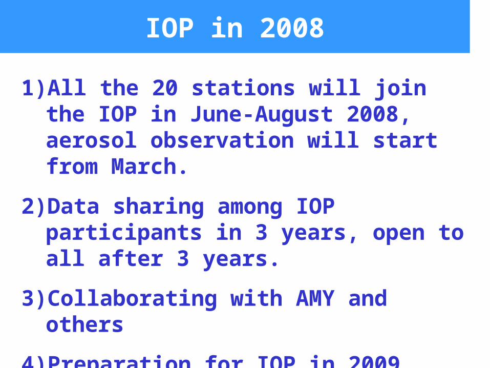
1)All the 20 stations will join the IOP in June-August 2008, aerosol observation will start from March.
2)Data sharing among IOP participants in 3 years, open to all after 3 years.
3)Collaborating with AMY and others
4)Preparation for IOP in 2009.
Regional Climate Model Intercomparison Project for Asia
1)To improve the simulation skills of regional climate models, and to meet the urgent needs of providing accurate regional climate change information to impact and assessment community, which has been one of the high priority areas in climatic change study
2)Participants: China(CMA, CAS, Nanjing Uni), US, Italy(ITCP), Japan, Korea.
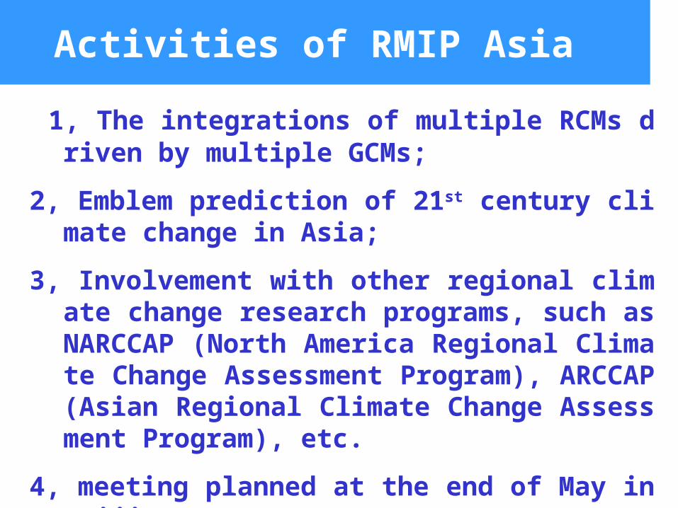
Activities of RMIP Asia
1, The integrations of multiple RCMs driven by multiple GCMs;
2, Emblem prediction of 21st century climate change in Asia;
3, Involvement with other regional climate change research programs, such as NARCCAP (North America Regional Climate Change Assessment Program), ARCCAP (Asian Regional Climate Change Assessment Program), etc.