12
2010 Annual R&D Report Remote Sensing Group
2010 Annual R&D Report
Remote Sensing Group
University of Lethbridge Remote Sensing Group Annual R&D Report 2010
2
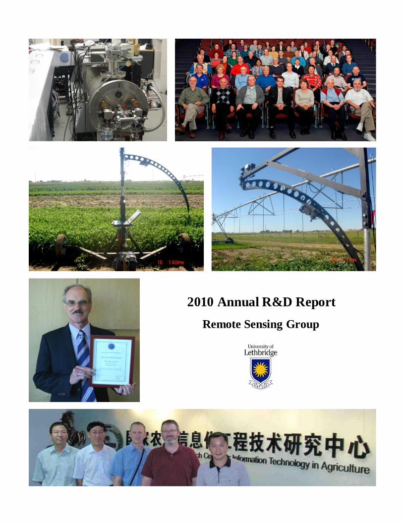
1. The far-infrared beam-line at the Canadian Light Source, Saskatoon, Saskatchewan.
2. Participants at the 20th
International Conference on Spectral Line Shapes, St. John’s, Newfoundland.
3. BRDF field work over barley in Fairfield, Alberta using the unique University of Lethbridge goniometer system.
4. The University of Lethbridge goniometer system at work near an irrigation system in Fairfield, Alberta.
5. Dr. Karl Staenz, recipient of the 2010 Gold Medal award from the Canadian Remote Sensing Society.
6. International cooperation at the National Engineering Research Centre for Informat ion Technology in Agriculture
(NERCITA), Beijing, China. Left to right: Dr. Zhijie Wang (University of Lethbridge), Dr. Jihua Wang
(NERCITA), Dr. Phil Teillet (University of Lethbridge), Dr. Craig Coburn (University of Lethbridge), and Dr.
Wenjiang Huang (NERCITA).
Report Editor
Dr. Ph ilippe M. Teillet
Department of Physics and Astronomy
University of Lethbridge
4401 University Drive W.
Lethbridge, A lberta T1K 3M4
Canada
Information Contact
Dr. Karl Staenz
Department of Geography
University of Lethbridge
4401 University Drive W.
Lethbridge, A lberta T1K 3M4
Canada
1 2
3 4
5
6
University of Lethbridge Remote Sensing Group Annual R&D Report 2010
3
Remote Sensing Group
Faculty
Craig Coburn, Department of Geography Derek Peddle, Department of Geography Adriana Predoi-Cross, Department of Physics and Astronomy Karl Staenz, Department of Geography Phil Teillet, Department of Physics and Astronomy
Adjunct Professors
Department of Physics and Astronomy: Brant Billinghurst, Canadian Light Source, Saskatoon, Saskatchewan Dionisio Bermejo, Instituto de Estructura de la Materia, Madrid, Spain Per Jensen, University of Wuppertal, Wuppertal, Germany Nadia Rochdi, Alberta Terrestrial Imaging Corporation, Lethbridge, Alberta
Department of Geography: Ron Hall, Canadian Forest Service, Edmonton, Alberta Anne Smith, Agriculture and Agri-Food Canada, Lethbridge, Alberta
Post-Doctoral Fellows
Zhijie Wang, Department of Physics and Astronomy
Research Assistants
Xiaomeng Ren, Department of Physics and Astronomy
Graduate Students
Ashley Bracken, Department of Geography, AMETHYST Award Student Subir Chowdhury, Department of Geography Cathy Kloppenburg, Department of Geography Amr Ibrahim, Department of Physics and Astronomy Deep Mazumdar, Department of Geography Aaron Mullin, Department of Geography Steve Myshak Department of Geography, AMETHYST Award Student Kean O’Shea, Department of Geography Ilia Parshakov, Department of Geography, AMETHYST Award Student Chad Povey, Department of Physics and Astronomy, AMETHYST Award Student Logan Pryor, Department of Geography, AMETHYST Award Student Gairik Roy, Department of Physics and Astronomy Hoimonti Rozario, Department of Physics and Astronomy, AMETHYST Award Student Shiyong Xu, Department of Geography, AMETHYST Award Student
Undergraduate Research Assistants
Josh Sorell, Department of Physics and Astronomy Jonathan Vos, Department of Physics and Astronomy
Administrative Support
Trevor Armstrong, AMETHYST Program Coordinator, University of Lethbridge Dana Andrei, Alberta Water and Environmental Science Building, University of Lethbridge Margaret Cook and Charlene Sawatsky, Department of Geography, University of Lethbridge Sheila Matson and Laurie Scott, Department of Physics and Astronomy, University of Lethbridge
University of Lethbridge Remote Sensing Group Annual R&D Report 2010
4
Overview
Introduction
The Remote Sensing Group (RSG) at the University of Lethbridge (UL) is composed primarily of faculty, students and other researchers from the Department of Geography and the Department of Physics and Astronomy, Faculty of Arts and Science. The RSG also collaborates with imaging scientists at the UL in the fields of neuro-imaging, image processing/computer science, kinesiology, and astronomy.
Primary Research Areas
Analysis of atmospheric trace gases
Atmospheric correction of satellite image data
Autonomous systems in support of post-launch satellite sensor calibration Bidirectional reflectance properties of Earth surfaces
Development of remote sensing applications in agriculture, rangeland, forestry, mountainous terrain, oil sands, water resources, etc
Hyperspectral imaging / imaging spectroscopy
Image classification, texture analysis, and spectral mixture analysis
Image processing and analysis methodologies
Investigations of molecular structures
Remote sensing laboratory and field analyses
Remote sensing instrumentation (field/airborne/atmospheric sensors)
Sensor radiometric calibration
Vegetation canopy reflectance modeling and inversion
NSERC CREATE AMETHYST Program
The University of Lethbridge received a prestigious NSERC Collaborative Research and Training Experience (CREATE) grant for an Advanced Methods, Education and Training in Hyperspectral Science and Technology (AMETHYST) Program. The AMETHYST Program will provide excellent support for research training over a six year period (2011-2016). It is designed to expose students to the broader context of imaging science and technology, with research foci in remote sensing methodologies, resource and environmental monitoring, greenhouse gas studies, and neuro-imaging. Student internships are offered at the undergraduate and graduate levels, including research placements in academic laboratories, government agencies and industry settings. In addition to periodic and ongoing research and training events, AMETHYST features two types of workshops. The annual multi-day Workshop on Hyperspectral Imaging Science and Technology (summer) provides an intensive interdisciplinary research training experience. The annual single-day Workshop on Career Development and Workforce Preparation (winter) offers trainees a unique and diverse training experience, allowing them to acquire a full scope of individual and team-oriented professional skills that are highly valued and optimized for today’s job market. Both workshops are open to participants from across Canada and internationally. More information is available on the AMETHYST web site: http://www.uleth.ca/fas/amethyst/.
University of Lethbridge Remote Sensing Group Annual R&D Report 2010
5
Remote Sensing Gold Medal Award
Dr. Karl Staenz, University of Lethbridge Professor of Geography and Remote Sensing Group Member, was awarded the prestigious Gold Medal from the Canadian Remote Sensing Society (CRSS) in 2010. This award recognizes a significant long-term contribution to the field of remote sensing in Canada and is the highest award in the country granted by the CRSS for Excellence in Remote Sensing. Staenz’ research has long been focused on spectral sensing, including the process of image data preprocessing, information extraction for various applications, and building intelligent image processing and monitoring systems. He worked at the Canada Centre for Remote Sensing, a branch of Natural Resources Canada, in Ottawa for over 20 years before joining the University of Lethbridge in 2006. The Gold Medal was awarded to Staenz in June 2010 at the 31st Canadian Symposium on Remote Sensing – the Prairie Summit – in Regina, Saskatchewan.
Multi-Disciplinary Major in Remote Sensing
The University of Lethbridge has initiated a new Multi-Disciplinary Major in Remote Sensing, combining the strengths of the university’s Department of Geography and Department of Physics and Astronomy. The program is designed to prepare B.Sc. graduates for a broad spectrum of job opportunities as well as graduate education and research.
Major R&D Funding Sources
Agriculture and Food Council of Alberta Alberta Ingenuity New Faculty Award Canadian Foundation for Innovation Infrastructure Operating Natural Sciences and Engineering Research Council of Canada Grants: Discovery, Strategic, CREATE University of Lethbridge Faculty of Arts and Science
Laboratories
The Remote Sensing Laboratory in the Alberta Water and Environmental Sciences Building (AWESB) consolidates various elements of UL remote sensing research. It is the home base for the UL goniometer systems, a variety of laboratory and field-deployable sensors and experimental target systems, 3-D structural measurement devices, and other specialised field equipment.
The Remote Sensing Calibration Spectrometry Laboratory is a highly specialized yet critical facility unique to Canada. The laboratory carries out spectroradiometric calibration of instrumentation used to support a variety of Earth and environmental science studies.
The Atmospheric Spectroscopy Laboratory in University Hall undertakes laboratory spectroscopy of terrestrial and planetary atmospheric molecules. The main instrument is a three-channel home-made laser spectrometer, tuneable from 1.48 to 3.8 micrometers. A variable-temperature single-pass absorption gas cell was designed and built in-house for the spectroscopic study of gases. This setup enables highly sensitive line shape studies and fundamental spectroscopic studies of molecular interactions. Tuneable diode laser absorption spectroscopy has also been used to develop an instrument capable of high-accuracy measurements of greenhouse gases such as N2O, CO2, and CH4. The field-portable instrument can be deployed in remote locations and used to measure greenhouse gas concentrations in real time.
University of Lethbridge Remote Sensing Group Annual R&D Report 2010
6
Instrumentation
AERONET/AEROCAN node Cimel CE-318 autonomous Sun-tracking photometer
Airborne Multispectral Camera System
ASD spectrometers (3): ASD FieldSpec 3, ASD FieldSpec 3 Hi-Res, and ASD FieldSpec Pro
ASD mercury argon calibration source assembly ALZSOLO
ASD RTS-3ZC Reflectance/Transmittance Integrating Sphere
HEMI digital hemispherical photography system
LAI-2000 plant canopy analyzer system
Pulnix AccuPiXEL cameras (6)
Science mode Cimel CE-318 autonomous Sun-tracking photometer
SVC HR-1024 field spectrometer
SWIR imaging spectrometer: Specim VN25E / MCT camera / Specim mirror scanner TRAC (Tracing Radiation and Architecture of Canopies) system
Trimble TSCL and ProXRS DGPS receivers
VNIR imaging spectrometers (2): Specim V10E / Hamamatsu C8484 / Specim mirror scanner
Yankee Environmental Systems SPUV sun photometer
Field Goniometer System
The UL Goniometer System version 2 (ULGS-2) apparatus has a unique design that incorporates a number of advancements over other goniometers for measuring bi-directional reflectance data that are used to support remote sensing analyses. It is the most advanced field goniometer system in the
world. The ULGS 2 uses a quarter circle positioning arc with a 2-m radius and no part of the apparatus touches the ground in the target area. This new design reduces the weight of the
apparatus, increases portability, allows positioning over a wider variety of surfaces, and facilitates significantly faster data acquisition. ULGS-2 incorporates a computer-controlled motor-driven instrument payload that rapidly samples target bidirectional reflectance distribution functions.
2010 Bibliography, University of Lethbridge Remote Sensing Group
Publications in Refereed Journals
Amyay, B., M. Herman, A. Fayt, L. Fusina, and A. Predoi-Cross. 2010. High resolution FTIR investigation of 12C2H2 in the FIR spectral range using synchrotron radiation. Chemical Physics Letters, 491 (1-3): 17-19.
Beres, B.L, K.N. Harker, G.W. Clayton, E. Bremer., J.T. O’Donovan, R.E. Blackshaw, and A.M. Smith. 2010. Influence of N fertilization method on weed growth, grain yield and grain protein concentration in no-till winter wheat. Canadian Journal of Plant Science, 90: 637-644.
Coburn, C.A., Van Gaalen, K.E., Peddle, D.R., and Flanagan, L.B., 2010. Anisotropic Reflectance Effects on Spectral Indices for Estimating Ecophysiological Parameters using a Portable Goniometer System. Canadian Journal of Remote Sensing, 36(S2): 355-364.
Devi, V.M., D. Chris Benner, C.E. Miller, and A. Predoi-Cross. 2010. Lorentz half-width, pressure-induced shift and speed-dependent coefficients in oxygen-broadened CO2 bands at 6227 & 6348 cm-1 using a constrained multispectrum analysis. Journal of Quantitative Spectroscopy and Radiative Transfer, 111 (16): 2355-2369.
University of Lethbridge Remote Sensing Group Annual R&D Report 2010
7
Gamon, J.A., Coburn, C.A., Flanagan, L.B., Huemmrich, K.F., Kiddles, C., Sanchez-Azofeifa, G.A. Thayer, D.R., Vescovo, L., Gianelle, D., Sims, D.A., Rahman, A.F., and Pastorello, G.Z. 2010. SpecNet Revisited: Bridging Flux and Remote Sensing Communities (Review Paper). Canadian Journal of Remote Sensing, 36(S2): 376-390.
Letts, M.G., Johnson, D.R.E. and Coburn, C.A. 2010. Drought stress ecophysiology of grass and shrub functional groups on opposing slopes of a temperate grassland valley. Botany 88(9), DOI: 10.1139/B10-054.
Liu, J., E. Pattey, J.R. Miller, H. McNairn, A. Smith, and B. Hu. 2010. Estimating crop stresses, aboveground dry biomass and yield of corn using multi-temporal optical data combined with Monteith’s crop growth model. Remote Sensing of Environment, 114:1167-1177.
Moruzzi, G., R.J. Murphy, R.M. Lees, A. Predoi-Cross, and B.E. Billinghurst. 2010. High-resolution synchrotron based Fourier transform spectroscopy of CH317OH in the 120-350 cm−1 far-infrared region. Molecular Physics, 108 (18): 2343-2353.
Moyer, J.R., G. Coen, R. Dunn, and A.M. Smith. 2010. Effects of Landscape Position, Rainfall, and Tillage on Residual Herbicides. Weed Technology, 24:361–368.
Peddle, D.R. 2010. Partial-blind model inversion of mountain forest structure from MODIS imagery. International Journal of Remote Sensing: Remote Sensing Letters, in press.
Peddle, D.R., K.F. Huemmrich, F.G. Hall, J.G. Masek, S.A. Soenen, and C.D. Jackson. 2010. Applications of the BIOPHYS algorithm for physically-based retrieval of biophysical, structural and forest disturbance information. IEEE Journal of Selected Topics in Applied Earth Observations and Remote Sensing , in press.
Peddle, D.R., S. Boon, A.P. Glover, and F.G. Hall. 2010. Forest structure without ground data: Adaptive full-blind multiple forward-mode canopy reflectance model inversion in a mountain pine beetle damaged forest. International Journal of Remote Sensing. 31(8):2123-2128. DOI: 10.1080/01431160903401361.
Pracna, P., A. Ceausu-Velcescu, A. Predoi-Cross, and Š. Urban. 2010. Rovibrational spectroscopy of the Fermi interacting v4 = 1 and v3 = v6= 1 levels of DCF3. Journal of Molecular Spectroscopy, 259: 1-10.
Predoi-Cross, A., A. Ibrahim, M. Herman, L. Fusina, G. Nivellini and G. Di Lonardo. 2010. The high resolution infrared spectrum of the ν4 band of 1,1,1- trifluoro–ethane, Molecular Physics, 108 (18): 2303-2307.
Predoi-Cross, A., W. Liu, R. Murphy, C. Povey, R.R. Gamache, A.L. Laraia, A.R.W. McKellar, D.R. Hurtmans, and V. Malathy Devi. 2010. Measurement and computations for temperature dependences of self-broadened carbon dioxide transitions in the 30012←00001 and 30013←00001 bands. Journal of Quantitative Spectroscopy and Radiative Transfer, 111 (9): 1065-1079.
Smith, A.M., and J.R. Buckley. 2010. Investigating RADARSAT-2 as a Tool for Monitoring Grassland in Western Canada. Canadian Journal of Remote Sensing, in press.
Smith, M.A.H., D. Chris Benner, A. Predoi-Cross, and V. Malathy Devi. 2010. Multispectrum analysis of 12CH4 in the ν4 spectral region: II. Self-broadened half widths, pressure-induced shifts, temperature dependences and line mixing, Database. Journal of Quantitative Spectroscopy and Radiative Transfer, 111 (9): 1152-1166.
Soenen, S.A., D.R. Peddle, R.J. Hall, C.A. Coburn, and F.G. Hall. 2010. Estimating Aboveground Forest Biomass from Canopy Reflectance Model Inversion in Mountainous Terrain. Remote Sensing of Environment, 114(7): 1325–1337. DOI: 10.1016/j.rse.2009.12.012.
Teillet, P.M., and G. Chander. 2010. Terrestrial reference standard sites for postlaunch sensor calibration, Canadian Journal of Remote Sensing, in press.
Teillet, P.M., X. Ren, and A.M. Smith. 2010. Suitability of rangeland terrain for satellite remote sensing calibration, Canadian Journal of Remote Sensing, in press.
University of Lethbridge Remote Sensing Group Annual R&D Report 2010
8
Book Chapters
Dasgupta, A., and A. Predoi-Cross. 2010. “Women in Physics”, Encyclopedia of Women in Today's World , SAGE Publications, ISBN: 9781412995962.
Teillet, Philippe M., and Craig A. Coburn. 2010. "Radiometric Correction." Encyclopedia of Geography, SAGE Publications. <http://www.sage-ereference.com/geography/Article_n952.html>.
Edited Volumes
Buckley, J.R., and A.M. Smith. 2010. Monitoring grasslands with Radarsat-2 quad-pol imagery. Proceedings of the 2010 IEEE International Geoscience and Remote Sensing Symposium (IGARSS-2010), Honolulu, Hawaii, USA. pp. 3090-3093.
Coburn, C.A, and Peddle, D.R. 2010 (Editors). Proceedings of the 30th Canadian Symposium on Remote Sensing, Lethbridge, Alberta, ISBN: 978-0-9781886-4-1, 1352 pages.
Conference Proceedings Publications
Hall, R.J. R.S. Skakun, A. Beaudoin, M.A. Wulder, E.J. Arsenault, P.Y. Bernier, L. Guindon, J.E. Luther, and M.D. Gillis 2010. Approaches for forest biomass estimation and mapping in Canada. Proceedings of the 2010 IEEE International Geoscience and Remote Sensing Symposium (IGARSS-2010), Honolulu, Hawaii, USA. pp. 1988-1991.
Ibrahim, A., A. Predoi-Cross, and P.M. Teillet. 2010. Techniques for Handling Channelling in High Resolution Fourier Transform Spectra Recorded with Synchrotron Sources, Proceedings of the 20th International Conference on Spectral Line Shapes, St. John’s, Newfoundland, American Institute of Physics, 1290: 147-151.
Malathy Devi, V., D. Chris Benner, C.E. Miller, and A. Predoi-Cross. 2010. Width and Shift Coefficients in O2-Broadened CO2: Bands at 6227 & 6348 cm-1 Using a Constrained Multispectrum Analysis, Proceedings of the 20th International Conference on Spectral Line Shapes, St. John’s, Newfoundland, American Institute of Physics, 1290: 179-183.
Mazumdar D.D., C.A. Coburn, P.M. Teillet, N. Rochdi and A.M. Smith. 2010. Extraction of LAI from agricultural crop canopy BRDF using PROSAIL model inversion. Proceedings of the 31st Canadian Symposium on Remote Sensing, Regina, Saskatchewan, pp. 209-212.
Peddle, D.R. and Coburn, C.A. (Guest Editors). 2010. Canadian Journal of Remote Sensing, Special Conference Issue: 30th Canadian Symposium on Remote Sensing, Lethbridge, Alberta, 36(2): 211-400.
Peddle, D.R., and F.G. Hall. 2010. Physically-based canopy reflectance model inversion of forest structure from MODIS imagery in boreal and mountainous terrain using the BIOPHYS-MFM algorithm, Proceedings of the International Geoscience and Remote Sensing Symposium (IGARSS’2010), Honolulu, Hawaii, USA, in press.
Peddle, D.R., F.G. Hall, K.F. Huemmrich, J.G. Masek, S.A. Soenen, and C.D. Jackson. 2010. Remote sensing of forest structure from MODIS imagery for biomass monitoring in boreal and mountainous terrain using the BIOPHYS-MFM algorithm. Proceedings of the 31st Canadian Symposium on Remote Sensing , Regina, Saskatchewan, in press.
Peddle, D.R., S. Boon, A.P. Glover, and F.G. Hall. 2010. Mountain pine beetle structural change assessment from pre-outbreak (1999) and post-outbreak (2007) satellite imagery us ing BIOPHYS-MFM canopy reflectance modeling near Prince George, British Columbia. Proceedings of the 31st Canadian Symposium on Remote Sensing, Regina, Saskatchewan, in press.
Pilger, N. Peddle, D.R. and Hall, R.J. 2010. MFM CR modelling of forest stand height. Proceedings of the 31st Canadian Symposium on Remote Sensing, Regina, Saskatchewan, pp. 245-248.
University of Lethbridge Remote Sensing Group Annual R&D Report 2010
9
Povey, C., A. Predoi-Cross, J. Sorell, and A. Chatelet. 2010. Line shape study of R-branch transitions in the ν1+ν2+ν4+ν5 band of acetylene over a range of temperatures. Proceedings of the 20th International Conference on Spectral Line Shapes, St. John’s, Newfoundland, American Institute of Physics, 1290: 189-194.
Predoi-Cross, A., and J.W.C. Lewis (Editors). 2010. Proceedings of the 20th International Conference on
Spectral Line Shapes, St. John’s, Newfoundland, American Institute of Physics, 1290, 303 pages.
Smith, A.M, J.R. Buckley, and G.L. Larson. 2010. Investigating Radarsat-2 Polarimetric Data for Native Grassland Mapping in Western Canada. Proceedings of the 31st Canadian Symposium on Remote Sensing , Regina, Saskatchewan, pp. 289-292.
Smith, A.M., and C. Kloppenburg. 2010. Remote Sensing Tools for Mapping Native Grassland Change in Western Canada. Proceedings of the 31st Canadian Symposium on Remote Sensing , Regina, Saskatchewan, pp. 293-296.
Smith, A.M., and J.R. Buckley. 2010. Mapping native grasslands in western Canada using fine resolution polarimetric Radarsat-2 data. Proceedings of the 3rd RADARSAT-2 Workshop, St Hubert, Quebec. ftp://ftp.asc-csa.gc.ca/users/symposiumR2/pub/, Select: 5 - Jeudi 30 septembre 2010 - Thursday September 30th 2010, Download: Smith, AnneM.pdf.
Wang Z., Coburn, C.A., Teillet, P.M. 2010. A new goniometer capability for image-based bidirectional reflectance distribution function data acquisition. Proceedings of the 31st Canadian Symposium on Remote Sensing, Regina, Saskatchewan, pp 325-328.
Wang, Z., C.A. Coburn, X. Ren, D.D. Mazumdar, S. Myshak, A. Mullin, and P.M. Teillet. 2010. Assessment of soil surface BRDF using an imaging spectrometer. Proceedings of SPIE Remote Sensing Conference on Sensors, Systems, and Next-Generation Satellites, Toulouse, France, pp?
Zhang, Y.L., A.M. Smith, and C. Kloppenburg. 2010. Grassland Composition and Percent Cover Estimation using Digital Hemispherical Photographs. Proceedings of the 31st Canadian Symposium on Remote Sensing , Regina, Saskatchewan, pp. 349-352.
Zhang, Y.L., A.M. Smith, B. van Hezewijk, and R. Bourchier. 2010. Detecting and Estimating the Density of Leafy Spurge from Ground Level and Airborne Remote Sensing Data. Proceedings of the 31st Canadian Symposium on Remote Sensing, Regina, Saskatchewan, pp. 353-356.
Zhang, Y.L., and A.M. Smith. 2010. Estimation of Percent Ground Cover in Grassland from Hyperspectral and Multi-Angle Remote Sensing Imagery. Proceedings of the 31st Canadian Symposium on Remote Sensing, Regina, Saskatchewan, pp. 345-348.
External Reports
Dasgupta, A., and A. Predoi-Cross. 2010. Women in Physics, The Multimedia Encyclopedia of Women in Today's World, 6 pages.
Moruzzi, G., R.J. Murphy, R.M. Lees, A. Predoi-Cross, and B. Billinghurst. 2010. High-Resolution FIR Spectra of the O-17 Isotopologue of Methanol for Astrophysical Applications, 2009 CLS Activity Report, pp. 76-77.
Predoi-Cross, A., A. Ibrahim, M. Herman, L. Fusina, G. Nivellini, and G. Di Lonardo. 2010. Spectroscopic Study of the ν4 Band of CH3CF3 Using Synchrotron Based Fourier Transform Spectra, 2009 CLS Activity Report, pp. 78-79.
Smith, A.M, Y. L. Zhang, R. Bourchier, G. L. Larson, C. Kloppenburg, B. van Hezewijk, J.R. Buckley, A.J. Coleman, and M. Hill 2010. Developing Earth Observation Tools to Measure the Current and Future Spatial Extent and Productivity in Grasslands of Western Canada. Annual Report to the Canadian Space Agency Government Related Initiatives Program (GRIP), 80 pages.
University of Lethbridge Remote Sensing Group Annual R&D Report 2010
10
Teillet, P.M. (Editor). 2010. 2009 Annual R&D Report, Remote Sensing Group, University of Lethbridge, Lethbridge, Alberta T1K 3M4, 12 pages.
2010 Professional Activities, University of Lethbridge Remote Sensing Group
Conferences, Workshops and Specialist Meetings
2010 IEEE International Geoscience and Remote Sensing Symposium, Honolulu, Hawaii, USA
2010 National Forest Pest Management Forum, Ottawa, Ontario
20th International Conference on Spectral Line Shapes, St. John’s, Newfoundland
22nd Colloquium on High-Resolution Molecular Spectroscopy, Poznan, Poland 31
st Canadian Symposium on Remote Sensing, Regina, Saskatchewan
4th
Annual University of Lethbridge GSA Conference, Lethbridge, Alberta
Annual Users Meeting, Canadian Light Source, Saskatoon, Alberta
Prairies Universities Seminar Series, Saskatoon and Regina, Saskatchewan
Workshop on Infrared Visible Optical Sensors (IVOS), Working Group on Calibration and Validation (WGCV), Committee on Earth Observation Satellites (CEOS), European Commission Joint Research Centre, Ispra, Italy
Service Activities and Memberships
Alberta Geomatics Group
American Society of Agronomy
American Society of Photogrammetry and Remote Sensing
Canadian Association of Geographers
Canadian Association of Physicists
Canadian Institute of Forestry, Rocky Mountain Section Council member, Program and Membership Committees
Canadian Remote Sensing Society Canadian Society of Agronomy
Co-chair, IEEE International Spaceborne Imaging Spectroscopy (ISIS) Working Group
Co-Editor, Proceedings of the 20th International Conference on Spectral Line Shapes, American Institute of Physics
College of Alberta Professional Foresters
Director of Communications, Regional Councillor for Alberta, Nunavut and Northwest Territories provinces and Co-Chair of the Committee to Encourage Women in Physics, Canadian Association of Physicists
Editorial Board, Canadian Journal of Forest Research
Editorial Board, Canadian Journal of Remote Sensing Editorial Board, Remote Sensing of Environment
Editorial Board, The Forestry Chronicle
Editors, Proceedings of the 30th Canadian Symposium on Remote Sensing , Canadian Remote Sensing Society
Environmental Mapping and Analysis Program Scientific Advisory Committee (EnSAG) for a spaceborne hyperspectral mission, German Aerospace Centre, Germany
Guest Editor, Special Issue: Terrestrial Reference Standard Test Sites for Post-Launch Calibration, Canadian Journal of Remote Sensing
Guest Editors, Special Issue: 30th Canadian Symposium on Remote Sensing, Canadian Journal of Remote Sensing
University of Lethbridge Remote Sensing Group Annual R&D Report 2010
11
IEEE Geoscience and Remote Sensing Society
Past-Chair, Canadian Remote Sensing Society
Remote Sensing Science Review Panel, Belgian Remote Sensing Program, Brussels, Belgium.
Scientific Advisory Committee (SAC), Tecterra, Canadian Networks of Centres of Excellence (NCE) and Alberta Innovates – Technology Futures
Society of Range Management. Subgroup on Infrared-Visible Optical Sensors (IVOS), Committee on Earth Observation Satellites
(CEOS) Working Group on Calibration and Validation
Technical Program Committee, 2010 Congress of the Canadian Association of Physicists (CAP), Toronto, Ontario
Technical Program Committee, 20th International Conference on Spectral Line Shapes, St. John’s, Newfoundland
Technical Program Reviewer, 2010 IEEE International Geoscience and Remote Sensing Symposium, Honolulu, Hawai’i, USA
Vice-Chair, Canadian Remote Sensing Society
Courses Taught
Introduction to Geography, Geography 1000
Introduction to Geographical Information Science, Geography 2735
Cartography, Geography 3700
Remote Sensing, Geography 3720
Advanced Remote Sensing, Geography 4725/5725 Spatial Modelling, Geography 4751
Seminar in Remote Sensing, Geography 4753/5753
Advanced Spatial Modelling and Geography, Geography 5751
Research Methods in Geography, Geography 5850
University of Lethbridge Remote Sensing Group Annual R&D Report 2010
12


