77
MARCH 2010 OAKAJEE PORT AND RAIL PROPOSED RAIL CORRIDOR SHORT RANGE ENDEMIC INVERTEBRATE SURVEY

MARCH 2010
OAKAJEE PORT AND RAIL
PROPOSED RAIL CORRIDOR
SHORT RANGE ENDEMIC INVERTEBRATE SURVEY

This page has been left blank intentionally

Oakajee Port and Rail
Proposed Rail Corridor
Short Range Endemic Invertebrate Survey
March 2010
i
OAKAJEE PORT AND RAIL
PROPOSED RAIL CORRIDOR
SHORT RANGE ENDEMIC INVERTEBRATE SURVEY

Oakajee Port and Rail
Proposed Rail Corridor
Short Range Endemic Invertebrate Survey
March 2010
ii
Document Status
Approved for Issue Rev. Author Reviewer/s Date
Name Distributed To Date
A Catherine Taylor N. Thompson 25/11/09
B N.Thompson L.Roque‐Albelo 15/12/09
C L.Roque‐Albelo N.Thompson 23/12/09 N.Thompson C.Miller 23/12/09
D C.Miller N.Thompson 25/01/10 M. Davis C.Miller 28/1/10
ecologia Environment (2010). Reproduction of this report in whole or in part by electronic, mechanical or chemical means including photocopying, recording or by any information storage and retrieval system, in any language, is strictly prohibited without the express approval of Oakajee Port and Rail and/or ecologia Environment.
Restrictions on Use
This report has been prepared specifically for Oakajee Port and Rail. Neither the report nor its contents may be referred to or quoted in any statement, study, report, application, prospectus, loan, or other agreement document, without the express approval of Oakajee Port and Rail and/or ecologia Environment.
ecologia Environment
1025 Wellington Street
WEST PERTH WA 6005
Phone: 08 9322 1944
Fax: 08 9322 1599
Email: [email protected]

Oakajee Port and Rail
Proposed Rail Corridor
Short Range Endemic Invertebrate Survey
March 2010
iii
TABLE OF CONTENTS
GLOSSARY OF TERMS ....................................................................................................................VII
1 INTRODUCTION ................................................................................................................ 1
1.1 PROJECT OVERVIEW..................................................................................................................1
1.2 LEGISLATIVE FRAMEWORK .......................................................................................................1
1.3 SURVEY OBJECTIVES..................................................................................................................2
1.4 OVERVIEW OF SHORT‐RANGE ENDEMISM IN INVERTEBRATES................................................4
2 PROJECT AREA .................................................................................................................. 9
2.1 GEOLOGY, LANDFORMS AND SOILS..........................................................................................9
2.2 LAND SYSTEM AND SOIL‐LANDSCAPE SYSTEM CLASSIFICATION ............................................10
2.3 BIOGEOGRAPHIC REGIONS .....................................................................................................11
2.4 CONSERVATION RESERVES IN THE REGION ............................................................................24
2.5 CLIMATE ..................................................................................................................................24
3 METHODS ....................................................................................................................... 29
3.1 SYSTEMATIC SURVEY – INVERTEBRATE PITFALL TRAPPING....................................................29
3.2 HAND FORAGING ....................................................................................................................30
3.3 LITTER SIFTING ........................................................................................................................30
3.4 LEAF LITTER COLLECTION........................................................................................................30
3.5 SITE SELECTION .......................................................................................................................30
3.6 SURVEY TIMING ......................................................................................................................32
3.7 LABORATORY METHODS.........................................................................................................32
3.8 SURVEY ADEQUACY.................................................................................................................32
3.9 CURATION AND SPECIES IDENTIFICATION ..............................................................................32
3.10 DETERMINATION OF SURVEY SAMPLING DESIGN AND INTENSITY.........................................33
3.11 SURVEY TEAM .........................................................................................................................34
4 RESULTS AND DISCUSSION.............................................................................................. 35
4.1 OVERVIEW...............................................................................................................................35

Oakajee Port and Rail
Proposed Rail Corridor
Short Range Endemic Invertebrate Survey
March 2010
iv
4.2 SURVEY ADEQUACY.................................................................................................................35
4.3 SPECIMENS..............................................................................................................................37
5 CONCLUSION .................................................................................................................. 43
6 REFERENCES.................................................................................................................... 45
TABLES
Table 3.1 – Summary of the particulars of techniques employed in the SRE survey. ............................29
Table 3.2 – Summary of OPR Rail SRE Survey Sites ................................................................................31
Table 3.3 – The List of Experts Used to Identify Potential SRE Taxa Found During the Survey..............33
Table 3.4 – SRE Invertebrate fauna survey constraints..........................................................................33
Table 3.5 – Field Survey Personnel.........................................................................................................34
Table 4.1 – Taxa Recorded During The OPR Rail Short‐range Endemic Invertebrate Survey.................42
FIGURES
Figure 1.1 – Location of the Project Area.................................................................................................3
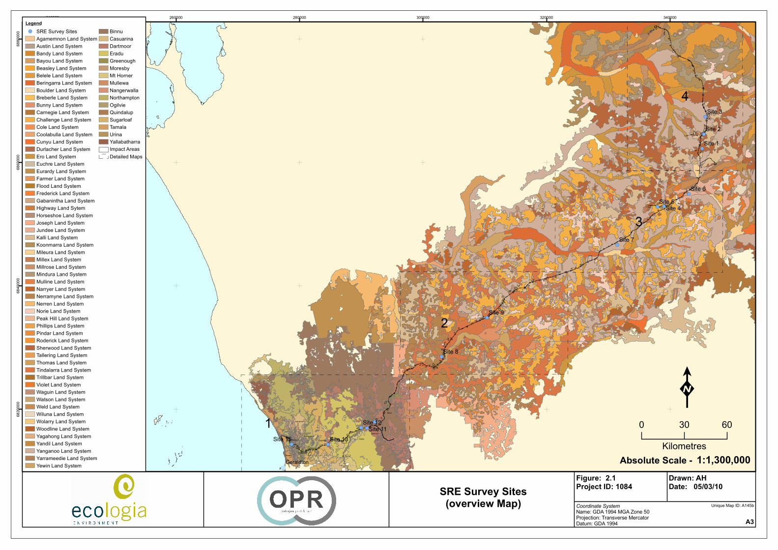
Figure 2.1 – Land Systems and Soil‐Landscape Systems of the Project Area including SRE Sites (Overview)..........................................................................................................................13
Figure 2.2 – Soil‐Landscape Systems of the Project Area including SRE Sites........................................15
Figure 2.3 – Land Systems of the Project Area including SRE Sites ........................................................17
Figure 2.4 – Land Systems of the Project Area including SRE Sites ........................................................19
Figure 2.5 – Land Systems of the Project Area including SRE Sites ........................................................21
Figure 2.6 – IBRA Subregions of the Project Area ..................................................................................23
Figure 2.7 – Geraldton (1941 – 2008).....................................................................................................25
Figure 2.8 – Mullewa (1925 – 2008).......................................................................................................25
Figure 2.9 – Meekatharra (1950 ‐2008) .................................................................................................26
Figure 2.10 – Rainfall one month before and during the survey time (BOM 2009)...............................27
Figure 4.1 – Species Accummulation Curve for Specimens Recorded to Date ......................................36

Oakajee Port and Rail
Proposed Rail Corridor
Short Range Endemic Invertebrate Survey
March 2010
v
APPENDICES
APPENDIX 1 SURVEY SITE DESCRIPTIONS...............................................................................................49

Oakajee Port and Rail
Proposed Rail Corridor
Short Range Endemic Invertebrate Survey
March 2010
vi
ACRONYMS
List all acronyms used in the report
BOM Bureau of Meteorology
DEC Department of Environmental Conservation
EIA Environmental Impact Assessment
EPA Environmental Protection Authority
EPBC Act Environment Protection and Biodiversity Conservation Act 1999
IBRA Interim Biogeographical Regionalisation of Australia
OPR Oakajee Port and Rail Pty Ltd
PER Public Environmental Review
SRE Short‐range Endemics
SAC Species Accumulation Curve
WC Act, WCA Wildlife Conservation Act 1950

Oakajee Port and Rail
Proposed Rail Corridor
Short Range Endemic Invertebrate Survey
March 2010
vii
GLOSSARY OF TERMS Term Definition
Oakajee Port and Rail Development The larger OPR project comprising the marine port, terrestrial port and rail components, each the subject of a separate approvals process.
Project Area
The area described in the Railway (Oakajee) Bill 2010 (Special Act Corridor), being generally a 4 km corridor within pastoral land areas and a 3.2 km corridor within freehold land areas.
Proposed alignment The rail construction and operational footprint, being a much smaller area, completely located within the Project Area.
The Project
The rail Project consisting of approximately 570 km of rail from Oakajee to the Jack Hills mine and including a rail spur to join the existing WestNet (Mullewa) line and another spur to Weld Range.
Approved Port
The deepwater port located at Oakajee. The Port was approved by the state government in 1998 by Ministerial Statement 469 and more recently updated by an approved 45C process.

Oakajee Port and Rail
Proposed Rail Corridor
Short Range Endemic Invertebrate Survey
March 2010
viii
This page has been left blank intentionally

Oakajee Port and Rail
Proposed Rail Corridor
Short Range Endemic Invertebrate Survey
March 2010
ix
EXECUTIVE SUMMARY
Oakajee Port and Rail Pty Ltd (OPR) propose to construct the Oakajee Rail Development (the Project); a multi‐user rail facility to service the expanding iron ore industry in the region.
The Project comprises approximately 570 km of rail track which runs from the Oakajee Port to the mid‐west mines, ending at Jack Hills. Associated with the rail track is the supporting infrastructure including bridges, construction camps, and laydown facilities.
OPR commissioned ecologia Environment (ecologia) to undertake an assessment of the short‐range endemic invertebrates of the Project Area. The purpose of the assessment, in line with PER level requirements, was to provide detailed information regarding the SRE of the Project Area, with special interest focussed on species of conservation significance.
The primary habitat focus of short‐range endemic surveys was isolated (‘island’) habitats within the Project Area. Island habitats may be any areas that maintain higher levels of moisture in the surrounding environment, such as:
• southern facing slopes;
• areas of deep leaf litter accumulation and under logs and rocks under permanent shade;
• in caves and their entrances; and
• in and around springs and permanent water bodies.
To date, approximately 24 species representing six orders of invertebrate fauna were recorded during the survey. Of these, two Mygalomorph spider species were short‐range endemics: Idiosoma ‘MYG018’ and Missulena ‘MYG045’. Nine species had undetermined SRE status due to either a lack of taxonomic knowledge from a paucity of data or from specimens being juveniles: the spiders Idiopidae indet. sp. juv, Kwonkan and Teyl, the pseudoscorpions Austrohorus (sp. juvenile and sp. unknown) and Beierolpium spp. (4 morphospecies). None of these species are currently listed as protected fauna; however, all are new to science and/or belong to genera composed predominantly of SRE species. These species require further taxonomic work or a full taxonomic revision before SRE status can be fully determined.
Statistical analysis to date showed adequate sampling effort, however this was pending taxonomic identification results of the snails. This information is expected in February/March 2010.
To conclude, despite several new species and SRE species being recorded throughout the Project Area, many appear to have a widespread distribution with respect to the Project Area and therefore the impact on these species from the proposed development is expected to be low. This is pending the remaining taxonomic identification of snails.

Oakajee Port and Rail
Proposed Rail Corridor
Short Range Endemic Invertebrate Survey
March 2010
x
This page has been left blank intentionally

Oakajee Port and Rail
Proposed Rail Corridor
Short Range Endemic Invertebrate Survey
March 2010
1
1 INTRODUCTION
1.1 PROJECT OVERVIEW
Oakajee Port and Rail Pty Ltd (OPR) propose the Oakajee Rail Development (the Project), a component of the larger Oakajee Port and Rail Development which also consists of the Oakajee Port (Approved Port) and the Oakajee Port Terrestrial Development which is the subject of a separate environmental impact assessment.
The Project comprises the development of approximately 570 km of rail formation within a rail transport corridor from mines in the northern mid‐west to an export port at Oakajee located approximately 24 km north of Geraldton. The main rail formation (of approximately 530 km) extends from the western boundary of Reserve 16200 near the north‐west coastal highway to Jack Hills mine in the north‐east. In addition, the Project includes a 10 ‐15 km spur to Weld Range and another 21 km spur to connect to the existing WestNet (Mullewa) line to potentially connect the mines south of Mullewa to the Oakajee Port. (Figure 1.1).
A Special Act of Parliament will authorise the construction of the railway within a defined corridor (Special Act Corridor, hereafter referred to as the Project Area). This corridor will generally be 4 km wide in pastoral land areas and 3.2 km wide within the freehold land area. The proposed alignment will be located within the Project Area, with a footprint of up to 200 m wide for construction purposes, plus additional area for supporting infrastructure, including camps, laydown areas and maintenance yards. The permanent rail operational corridor will be up to 100 m wide.
1.2 LEGISLATIVE FRAMEWORK
Federal and State legislation applicable to the conservation of native fauna include, but are not limited to, the Environment Protection and Biodiversity Conservation Act 1999, the Wildlife Conservation Act 1950, and the Environmental Protection Act 1986. Section 4a of the Environmental Protection Act 1986 requires that developments take into account the following principles applicable to native fauna:
• The Precautionary Principle
Where there are threats of serious or irreversible damage, a lack of full scientific certainty should not be used as a reason for postponing measures to prevent environmental degradation.
• The Principles of Intergenerational Equity
The present generation should ensure that the health, diversity and productivity of the environment is maintained or enhanced for the benefit of future generations.
• The Principle of the Conservation of Biological Diversity and Ecological Integrity
Conservation of biological diversity and ecological integrity should be a fundamental consideration.
This document includes background information on the project, a literature review of the SRE fauna of Geraldton Sandplains, Tallering and Murchison bioregions; particularly in reference to the habitats and environments of the project. The conservation significance of fauna in Western Australia is also outlined.

Oakajee Port and Rail
Proposed Rail Corridor
Short Range Endemic Invertebrate Survey
March 2010
2
The document was constructed with a view to satisfy the requirements of EPA Guidance Statement No. 56: Terrestrial Fauna Surveys for Environmental Impact Assessment in Western Australia (EPA 2004). In relation to SRE fauna the guidance statement states that:
“Comprehensive systematic reviews of different faunal groups often reveal the presence of short‐range endemic species (Harvey 2002). Among the terrestrial fauna there are numerous regions that possess short‐range endemics. Mountainous terrains and freshwater habitats often harbour short‐range endemics, but the widespread aridification and forest contraction that have occurred since the Miocene has resulted in the fragmentation of populations and the evolution of many new species. Particular attention should be given to these types of species in environmental impact assessment because habitat loss and degradation will further decrease their prospects for long‐term survival.”
This document also satisfies the requirements of the later released Guidance statement 20: Sampling of Short‐range Endemic Invertebrate Fauna for Environmental Impact Assessment in Western Australia (EPA 2009b).
Harvey (2002) considered that although there were occasional SREs among the vertebrates and insects, there were much higher numbers among the molluscs, earthworms, some spider groups (especially the mygalomorphs), millipedes, and some groups of crustaceans. SREs generally possessed similar ecological and life history characteristics, especially poor powers of dispersal, confinement to discontinuous habitats, slow growth, and low fecundity.
Some better known SRE species have been listed as threatened or endangered under State or Commonwealth legislation in the Wildlife Conservation Act 1950 and/or Environment Protection and Biodiversity Conservation Act 1999, but the majority have not. Often the lack of knowledge about these species precludes their consideration for listing as threatened or endangered. Listing under legislation should therefore not be the only conservation consideration in environmental impact assessment.
The State is committed to the principles and objectives for the protection of biodiversity as outlined in The National Strategy for the Conservation of Australia's Biological Diversity (Commonwealth Government 1996). The EPA expects that environmental impact assessment will consider impacts on conservation of SREs (EPA 2004).
1.3 SURVEY OBJECTIVES
The objectives of the survey were to provide:
a) An inventory of the SRE invertebrate fauna species occurring in the Project Area, incorporating recent published and unpublished records.
b) A review of regional and local conservation value of invertebrate fauna occurring within the Project Area.

MEEKATHARRA
YUIN
YANDI
YALGOO
MULLEWA
MILEURA
DARTMOOR
WELD RANGE
TWIN PEAKS
NORTHAMPTON
MOUNT MAGNET
MOUNT WITTENOOM
Geraldton
150000 300000 450000 600000 75000067
5000
069
0000
070
5000
0
LegendOPR Proposed Rail Corridor
Coordinate SystemName: GDA 1994 MGA Zone 50Projection: Transverse MercatorDatum: GDA 1994 A4
Figure: 1.1Project ID: 1126
Drawn: AHDate: 27/11/09
K0 60 120
Kilometres1:2,700,000Absolute Scale -
Unique Map ID: A024Location of the Study Area
Geraldton

Oakajee Port and Rail
Proposed Rail Corridor
Short Range Endemic Invertebrate Survey
March 2010
4
1.4 OVERVIEW OF SHORT‐RANGE ENDEMISM IN INVERTEBRATES
The decline in biodiversity of terrestrial communities has already been observed both nationally and state‐wide (CALM 2004). There is also an increasing shift in environmental protection from species based conservation to biodiversity based conservation (Chessman 1995; Burbidge et al. 2000; McKenzie et al. 2000) and one of the important considerations involved in this is the presence of endemic species.
Endemism refers to the restriction of species to a particular area, whether it is at the continental, national or local level (Allen et al. 2002). This review focuses on short‐range endemics (SRE), those species that exhibit tight local range restrictions. It outlines the major paths to short‐range endemism, the current knowledge of short‐range endemism in Australia (with an emphasis on Geraldton Sandplains, Tallering and Murchison bioregions), and the conservation significance of such species. It is important to note that the individual taxa and broader groups discussed are not an exhaustive list of all SRE. This is due to the fact that SRE are dominated by invertebrate species, which are historically understudied and in many cases lack formal descriptions. An extensive, reliable taxonomic evaluation of these species has begun only relatively recently and thus the availability of literature relevant to SRE’s is relatively scarce.
1.4.1 Threats to Short‐Range Endemics
Short‐range endemism is influenced by numerous processes generally contributing to the isolation of a fauna species. A number of factors including life history, physiology, habitat requirements, habitat availability, the ability and opportunity to disperse, biotic and abiotic interactions and historical conditions, influence not only the distribution of a taxon, but also the tendency for differentiation and speciation (Ponder and Colgan 2002).
Isolated populations of both plants and animals tend to differentiate both morphologically and genetically as they are influenced by different selective pressures over time. Additionally, a combination of novel mutation and genetic drift promote the accumulation of genetic differences between isolated populations. Conversely, the maintenance of genetic similarity is promoted by a lack of isolation through migration between the populations, repeated mutation and balancing selection (Wright 1943). The amount of differentiation and speciation between populations will be determined by the relative magnitude of these factors, with the amount of migration generally being the strongest determinant. Migration is hindered by poor dispersal ability of the taxon as well as geographical barriers to dispersal. Thus, those taxa that exhibit short‐range endemism are generally characterised by poor dispersal, reliance on habitat types that are discontinuous, low growth rates and low fecundity (Harvey 2002).
A number of habitats in Australia contain SRE’s because they are surrounded by geographic barriers. Islands are a classic example where terrestrial fauna are surrounded by a marine environment which impedes migration and thus genetic flow. Similarly, isolated habitats such as mountains, aquifers, lakes, and caves are essentially islands of differing environmental conditions amongst the surrounding landscape. Within Western Australia, caves and other subterranean habitats are examples of areas where short‐range endemics are common (Harvey 2002).
Historical connections of habitats are also important in determining species distributions and often explain patterns that are otherwise inexplicable by current conditions. Many SRE’s are those from relict taxa (organisms surviving as a remnant of an otherwise extinct species) and are confined to

Oakajee Port and Rail
Proposed Rail Corridor
Short Range Endemic Invertebrate Survey
March 2010
5
certain habitats and in some cases geographic areas (Main 1996). Relict taxa include species dating back to Gondwanan periods that have very restricted natures.
In Western Australia, relict taxa are generally fragmented populations from lineages reaching back to historically wetter periods. During the Miocene period (from 25 million to 13 million years ago), the aridification of Australia resulted in the contraction of many areas of moist habitat and the fragmentation of populations of fauna occurring in these areas (Hill 1994). With progressively dryer and more seasonal climatic conditions since this time, the most favourable habitats have now become increasingly fragmented and such fauna are now restricted to specialised moist microhabitats which simulate, on a small scale, an earlier, more widespread habitat (Main 1996). Many of the current species have restricted distributions as a result of these processes.
Relict species now generally persist in habitats characterised by permanent moisture and shade, with conditions provided by high rainfall (Main 1996). Such conditions can be seen at sites adjacent to granite outcrops (which benefit from rainwater runoff), mountain summits, swampy headwaters of river systems and caves (Main 1996). Topography, proximity to the coast and directional orientation are also influential in determining relict habitats. Due to the isolation of populations, many relict species of cave fauna have very disjunct populations, indicating that their dispersal is limited (Clarke and Spier‐Ashcroft 2003).
1.4.2 Conservation of Short‐Range Endemics
Specific characteristics of sites in south‐west Australia in which relict SRE species might be found were proposed by Main (1996, 1997) , following Main and Main (1991), and include areas:
• unaffected by salinisation;
• of high rainfall with short summer drought;
• topographically high along the coast and subject to frequent mists, cloud and drizzle;
• adjacent to rocks from which water is shed;
• of impeded groundwater flow so producing winter wet swamps;
• of streams with extensive fresh headwater swamps and year round flow;
• where vegetation can harvest water from fog or cloud drip from leaves and stem flow e.g. tingle forest and south coast dunes and heath;
• with southern or south‐west aspects which are thus sheltered from summer insolation e.g. valley slopes and wet valley floors; and
• of intact forest canopy under which the characteristics under storey shrubs and herbs occur.
To these, Horwitz and Rogan (2003) added:
“Springs and caves streams or other expressions of interstitial or groundwater”.
1.4.3 Short Range Endemics in the Project Area
SREs are common among the invertebrates. Many species are confined to topographically or geographically restricted areas and specialised microhabitats because of their small size and often

Oakajee Port and Rail
Proposed Rail Corridor
Short Range Endemic Invertebrate Survey
March 2010
6
specialised behaviour, typical for relict species. These microhabitats provide areas of short‐range endemism and are vulnerable to artificial disturbances imposed by agriculture and other rural and urban disruptions to the landscape, for instance roads and other human constructions (Main 1996).
Widespread and uniform short‐range endemism is found in both terrestrial and freshwater molluscs, onychophorans, millipedes, some arachnids and some crustaceans. Short‐range endemism also occurs in other groups but is not uniform throughout (Harvey 2002).
Many taxa that appear to be rare are often poorly documented and could prove to be more widespread than originally thought. Nevertheless, recent taxonomic and survey work has revealed that SRE species are common in Australia, and that (although rare) some taxonomic groups such as Megascolecidae are composed entirely of SRE species (Harvey 2002).
There is little published evidence of SRE fauna to date from the Geraldton Sandplains, Tallering and Murchison bioregions. This is most likely due to the historical lack of invertebrate research, as common in most areas of Australia. Geraldton Sandplains have a potential to provide refuges for SRE species where moist conditions have persisted during the continent’s increasing aridity, as is the case for numerous relict invertebrate taxa in the south‐west region of Western Australia (Abbott 1994; Horwitz and Rogan 2003). Due to the history of pastoral land use in the area, suitable remnant vegetation associations may function as refugia for invertebrates with restricted distributions and thus be important for their long‐term survival.
Short‐range endemic members of groups such as millipedes (Diplopoda), centipedes (Chilopoda), land snails (Mollusca), native earthworms (Megascolecidae) and trapdoor spiders (Mygalomorphae) have been recorded (Abbott 1994; Harvey et al. 2000) or are considered likely to exist on the Geraldton Sandplains and Murchison bioregions and are expected to occurs also within the Tallering bioregion.
1.4.4 Local Endemism of Invertebrate Groups
Isopods (crustaceans), amphipods (crustaceans), annelids (worms), onychophorans (velvet worms) molluscs (snails), arachnids (spiders and scorpions) and myriapods (millipedes and centipedes) are all known to show local endemism in southern Australia (Abbott 1994; Harvey 2002; Horwitz and Rogan 2003). Many of these taxa are confined to freshwater systems but can occur in shallow subterranean systems in saturated soils, or saturated sediments of wetlands, where they can survive seasonal drought by remaining in damp soil (Horwitz and Rogan 2003).
1.4.4.1 Annelida (Worms) and Onychophora (Velvet worms)
The taxonomic status of the earthworm family Megascolecidae in Western Australia was revised by Jamieson in 1971. This study concluded that most of the earthworm genera are made up almost entirely of SRE. This is also the case with the velvet worms (Onychophorans). A number of taxonomic revisions have been conducted since in both groups and the number of taxa has expanded. Furthermore, a number of new species are still to be described (Harvey 2002).
Of the earthworms, a single Acanthodriline species, Microscolex dubius, occurs in the coastal regions of south‐western Western Australia (Dyne and Jamieson 2004). The known distribution of earthworms in the south‐west is shown by Abbott (1994) as a series of isolated dots on a map within the 400 mm rainfall zone. This highlights the current lack of information and distribution data for earthworms occurring in the Project Area and indeed throughout the state.

Oakajee Port and Rail
Proposed Rail Corridor
Short Range Endemic Invertebrate Survey
March 2010
7
Velvet worms exhibit one of the most extreme forms of short‐range endemism inhabiting moist habitats (Harvey 2002). Very few of these species exceed ranges of 200 km² and some are restricted to single localities and have high genetic differentiation, indicating very little mobility and dependence on their permanently moist habitats (Harvey 2002).
The most widely distributed onychophoran appears to be Occiperipatoides gilesii, which occurs throughout the Darling Range, with occasional outlying populations on the Swan Coastal Plain (Harvey 2002). Onychophorans inhabit permanently moist habitats, usually in native forests, and are most commonly found in or under rotting logs (Harvey 2002). They exhibit one of the most extreme forms of SRE, with some species restricted to single localities and with high genetic differentiation, indicating poor mobility and a strong reliance upon permanently moist habitat for survival (Harvey 2002).
1.4.4.2 Arachnida (Spiders)
The majority of spider species in Australia are widely distributed, due to their ability to balloon (Harvey 2002). However, some of the Mygalomorph species (primitive terrestrial, burrowing spiders, including trapdoor and funnel‐web spiders) exhibit short‐range endemism with some of the Mygalomorph genera completely composed of SRE. Many of these species are restricted to habitat isolates such as rainforest patches (Raven 1982) or mountain peaks.
The Mygalomorphae are predominantly burrowing spiders, which occasionally make tubular silk nests in bark or moss on tree trunks. A number of Mygalomorph species occur in the south‐west of Western Australia and have highly restricted ranges. Mygalomorphs are relictual in their distribution, long‐lived and relatively sedentary with poor dispersal ability. They also have very specific microhabitat preferences (Main 1987). In Western Australia, most Mygalomorph genera are confined to humid and forested regions, with some persisting in favourable (moist) microhabitats within more arid areas (Main 1991).
1.4.4.3 Crustacea (Crustaceans)
Three families of the freshwater isopod suborder Phreatoicidea occur in Australia. Most are highly endemic, often allopatric, and all are constrained by their specific habitat requirements of permanent fresh water lakes and streams (see references within Harvey (2002)) and thus are not likely to be found in the Project Area. Similarly, the habitat requirements of other commonly targeted south‐west SRE crustacean species, such as Peludo paraliotus, Platypyga subpetrae, Hemiboeckella powellensis, and the endangered crayfish genus Engaewa, are not present and thus the taxa are not likely to be found in the Project Area.
1.4.4.4 Mollusca (Snails)
Numerous species of freshwater molluscs from many genera have been identified in Australia, with most being short‐range endemics with highly restricted ranges (Harvey 2002). Freshwater snails of the family Hydrobiidae have recently been shown to be diverse in Australia (Ponder et al. 1999). Many hydrobiids show small morphological differences between populations, even in those from adjacent drainages (Ponder 1982; Ponder et al. 1993) and these differences are often indicative of marked genetic differentiation (Ponder et al. 1994; Ponder et al. 1995; Ponder et al. 1996; Ponder and Colgan 2002).

Oakajee Port and Rail
Proposed Rail Corridor
Short Range Endemic Invertebrate Survey
March 2010
8
Small streams and, to a lesser extent, local groundwater seepages and springs are the major habitats of the majority of hydrobiid species in south‐western Australia (Ponder 1997). Hyrdobiids have very poor powers of dispersal and are good indicators of long term permanent water due to their restricted distributions and local genetic differentiation (Ponder 1997).
The terrestrial molluscan fauna also have highly restricted ranges with many families consisting entirely of SRE’s (Harvey 2002). Land snails inhabit microhabitats across much of the state, from the Kimberley to the moist uplands of the Stirling and Porongurup Ranges. In the south‐west of Western Australia, land snails are patchily distributed “in a mosaic” with distributions seemingly influenced by topography and soil type (S. Slack‐Smith, pers. comm., August 2007). On a finer scale, leaf litter and calcrete concentrations in soil can influence occurrence of land snails. Rocky habitats associated with higher altitudes are more likely to contain species of restricted land snails than the lowlands areas of the south‐west of Western Australia, where species can disperse more readily. Salinity levels in soil can also affect the distribution of land snails as many are intolerant of increasing salinity levels.
Short‐range endemic molluscs potentially occurring at or near the Project Area include members of the genus Bothriembryon, such as B. kendricki that occurs on the Swan Coastal Plain, escarpment, and plateau (Hill et al. 1983).
1.4.4.5 Myriapods (Millipedes and Centipedes)
Despite millipedes being highly abundant in soil and leaf litter, and highly diverse at the level of order (Harvey 2002), they are inadequately studied and relatively little is known of their biogeography.
Recent research into the paradoxosmatid genus, Antichiropus (endemic to south‐western Australia and South Australia) has revealed an extensive array of taxa, most of which possess extremely short‐ranges (Harvey 2002). These large, black millipedes are mostly undescribed, and all are restricted to relatively small geographical areas (M. Harvey and P. West, pers. comm. October 2006). Approximately 90 species have been recorded so far, with most species known from single localities (Harvey 2002). The lack of mobility of both juvenile and adult millipedes, coupled with extremely seasonal life cycles, suggest that such species are extremely limited in their dispersal. Antichiropus variabilis is known from the Darling Ranges east of Perth, with isolated occurrences as far south as Manjimup and Forest Grove (Harvey 2002). However, the only relevant Swan Coastal Plain record is of a number of unidentified female juvenile Antichiropus, which were recently recorded in Malaga as part of the survey for the Stage 2 extension of Hepburn Avenue (Speers and Wasaha 2004).
The genus Antichiropus includes species that appear restricted to seasonally moist biotypes with individuals seemingly active for only a short period during times of high winter rainfall (M. Harvey and P. West, pers. comm., October 2006). It is likely that many millipedes show allopatric speciation and extremely short‐ranges, especially in areas where soil and vegetation vary considerably across the landscape (Harvey 2002).
Currently centipedes are not officially recognised as a group which contains SRE species. Recent personal communication with Matt Colloff (CSIRO) however, indicated that taxon with in the Geophilomorpha sub‐order of centipedes is likely to contain restricted species. As more research into invertebrates is conducted as part of the EIA process, the distribution of taxon within this poorly known group will improve.

Oakajee Port and Rail
Proposed Rail Corridor
Short Range Endemic Invertebrate Survey
March 2010
9
2 PROJECT AREA
2.1 GEOLOGY, LANDFORMS AND SOILS
The Project Area dissects (Beard 1976) Murchison and Greenough Province. The Murchison Province incorporates the Murchison Region, which incorporates the Upper Murchison and Yalgoo sub‐regions, describing the pastoral land area and the Greenough Province incorporates the Geraldton Region, describing the freehold land area. The geology, landforms and soils of these areas are discussed below.
2.1.1 Geology, Landforms and Soils of the Pastoral Land Area
The Murchison Province, which incorporates Beard’s (1976) Murchison region, is described by Tille (2006) as an area of “hardpan wash plains and sandplains (with some stony plains, hills, mesas and salt lakes) on the granitic rocks and greenstone of the Yilgarn Craton”. While the soils are described as “red loamy earths, red sandy earths, red shallow loams, red deep sands and red‐brown hardpan shallow loams (with some red shallow sands and red shallow sandy duplexes)” (Tille 2006).
Most of the western boundary of the Yilgarn Block was formed by the Darling Fault (Beard 1976). The Perth Basin lies to the west of the Yilgarn Block and contains mostly sedimentary rocks of sandstone and shale. The Northampton Block is a formation of the Perth Basin, composed of substantially metamorphosed rocks; granulites and some felspathic quartzite; large granite intrusions are also evident.
The geology of Beard’s (1976) Murchison region is dominated by the Archaean Yilgarn Block (also known as the Yilgarn Craton), which forms the nucleus of the Western Australian Shield. Gneisses and granites are the major components of the Yilgarn Block, with minor infolded belts of metamorphic sedimentary and igneous rocks. Metamorphic rocks are composed of various volcanic and sedimentary materials including: ultramafic and mafic rocks (essentially basalts), acid lavas and tuffs, chemical sedimentary rocks such as banded ironstone, jaspilite and chert, and clastic sedimentary rocks comprising shale, siltstone, sandstone, greywacke and conglomerate. Metamorphic belts are mineralized and tend to form ranges of hills, as they are harder and more resistant than gneiss and granite ‐ the latter generally underlie plains, particularly sandplains. The major soil type present in the Murchison region is shallow earthy loam overlying red‐brown hardpan.
The Upper Murchison sub‐region of Beard’s (1976) Murchison region is described as generally hilly and undulating terrain, with shallow soils and granite exposure in the hills. The Weld Range and the Jack Hills are the main ranges of the sub‐region, and are formed by resistant metamorphic rocks (Beard 1976). These greenstone belts exhibit banded ironstone formations (Elias 1982). Curry et al. (1994) describe the Murchison River catchment and surrounds as an area dominated by granite‐greenstone terrain, while very flat plains derived from colluvium and alluvium widely separate the hill ranges. Soils are predominantly shallow, sandy and infertile, and are underlain by red‐brown siliceous hardpan across most of the lower areas.
The terrain of the Yalgoo sub‐region of Beard’s (1976) Murchison region is undulating and moderately dissected, with small remnants of the Tertiary land surface existing as sandplains. Low ranges of hills are created by metamorphic rocks. An inventory and condition survey of the Sandstone‐Yalgoo‐Paynes Find Area was carried out by Payne et al. (1998). They describe the area as dominated by granite‐greenstone terrain, with gently sloping pediments widely separating

Oakajee Port and Rail
Proposed Rail Corridor
Short Range Endemic Invertebrate Survey
March 2010
10
occasional ranges. Sheetflood alluvial plains (very gently inclined) are upslope from salt lakes. Most soils are characterized as shallow, sandy and infertile, generally with the lower areas underlain by red‐brown siliceous hardpan.
2.1.2 Geology, Landforms and Soils of the Freehold Land Area
Playford et al. (1970) describe four main physiographic units on the mainland of the Geraldton region: the Victoria Plateau, the Greenough Flats, the river drainage systems, and the coastal belt. The Victoria Plateau is a gently undulating sandplain approximately 240 m above sea level. Laterite is overlain by sand, and is exposed at dissected margins of the sandplain. Sand dunes are present in some areas, and flat‐topped mesas have been formed by remnants of the plateau. The Greenough Flats form the floodplain near the mouth of the Greenough River. The river drainage systems include the Greenough, Chapman, Hutt and Bowes Rivers. The coastal belt unit includes a band of coastal limestone and sand dunes.
Tille (2006) describes the Greenough Province, which incorporates part of Beard & Burn’s (1976) Geraldton area, as a “laterised plateau (dissected at the fringes) on the sedimentary rocks of the Perth Basin and gneiss of the Northampton Complex”, with soils of “yellow deep sands and pale deep sands, with some gravelly pale deep sands and red‐brown hardpan shallow loams”.
2.2 LAND SYSTEM AND SOIL‐LANDSCAPE SYSTEM CLASSIFICATION
Land Systems
Land systems are described using the biophysical characteristics of geology, landforms, vegetation and soils (Curry et al. 1994); (Payne et al. 1998).
Curry et al. (1994) undertook a regional inventory of the Murchison River catchment and surrounds to document the land systems present and the condition of each. The survey area covered 88,360 km2, and covered between Meekatharra and Mount Magnet in the east, to the catchments of the Greenough and Wooramel Rivers in the west. Payne et al. (1998) carried out a regional inventory of the Sandstone‐Yalgoo‐Paynes Find area to document the land systems present and the condition of each. The survey area covered approximately 94,700 km2.
The pastoral section of the Project Area crosses 30 of the land systems mapped by Curry et al. (1994) and Payne et al. (1998). These land systems and their locations in the Project Area are shown in Figure 2.1 and Figures 2.3 to 2.5.
The most commonly occurring land systems in the pastoral section of the Project Area were the Yanganoo (19.8%), Tindalarra (16.3%) and Challange (9.6%). The land systems with the highest percent of the total land system in the Project Area were Weld (9.7%), Yarrameedie (10.3%) and Millex (6.0%).
Soil‐landscape Systems
Rogers (1996) conducted an inventory of soil and land resources of the Geraldton agricultural region, covering an area of approximately 20,600 km2. The survey area incorporated the Shire of Mingenew and the agricultural zones in the Shires of Chapman Valley, Greenough, Irwin, Morawa, Mullewa and Northampton. Fifty‐one soil‐landscape systems are described, based on geology, landform and soil characteristics.
The freehold section of the Project Area crosses 11 of the soil‐landscape systems mapped in the area. The locations of these soil‐landscape systems in the Project Area are provided in Figure 2.2.

Oakajee Port and Rail
Proposed Rail Corridor
Short Range Endemic Invertebrate Survey
March 2010
11
The most commonly occurring soil‐landscape systems in the freehold section of the Project Area were the Dartmoor system (27.4%), Binnu system (20.1%) and Eradu system (14.3%). The soil‐landscape systems with the highest percent of the total system area contained in the Project Area were the Greenough system (11.1%), Moresby system (7.4%) and Dartmoor system (6.7%).
2.3 BIOGEOGRAPHIC REGIONS
The Interim Biogeographic Regionalisation for Australia (IBRA) classifies the Australian continent into regions (bioregions) of similar geology, landform, vegetation, fauna and climate characteristics (Department of the Environment, Water, Heritage and the Arts (DEWHA), 2009). According to IBRA (Version 6.1) the Project Area crosses three of these bioregions; Murchison (MUR), Yalgoo (YAL) and the Geraldton Sandplains (GS). Each of these IBRA bioregions is further divided into subregions as described below and mapped in Figure 2.6.
2.3.1 Murchison Bioregion (MUR) ‐ Western Murchsion Subregion (MUR2)
The Murchison (MUR) bioregion is divided into two subregions ‐ Eastern Murchison (MUR1) and Western Murchison (MUR2). A section of Project Area occurs in the Western Murchison (MUR2) subregion. Extensive hardpan wash plains dominate this subregion, and granite and greenstone rocks outcrop in the northern part of the Yilgarn Craton (Desmond et al. 2001). The Western Murchison (MUR2) subregion contains the easternmost portion of the rail including the Jack Hills Loop and the Weld Range Link (DEC 2002). Pastoralism is the dominant land use (96%) with degradation of the region widespread as a result of this and feral herbivores.
The vegetation of the Western Murchison (MUR2) subregion is described by Desmond et al. (2001) as Acacia aneura low woodlands, rich in ephemerals, and generally with bunched grasses on rocky outcrops and fine‐textured Quaternary alluvial and elluvial surfaces. Surfaces associated with drainage systems occur throughout, with hummock grasslands on Quaternary sandplains, saltbush shrublands on calcareous soils and Tecticornia species low shrublands on saline alluvium.
2.3.2 Yalgoo Bioregion (YAL) ‐ Tallering Subregion (YAL2)
The Yalgoo (YAL) bioregion is an interzone between the south‐western bioregions and the Murchison bioregion (Desmond & Chant, 2001a), and it is divided into two subregions – Edel (YAL1) and Tallering (YAL2). A section of the Project Area occurs in the Tallering (YAL2) subregion. This subregion is dominated by red sandy plains and sandy earth plains of the western Yilgarn Craton. The Yalgoo bioregion represents the westernmost section of the pastrol land area. The predominant land use in the Tallering subregion is grazing on native pastures (approx 77%) (Payne et. al. 1998).
The vegetation of the Yalgoo (YAL) bioregion is characterised by red sandy plains, supporting low to open woodlands of Eucalyptus, Acacia and Callitris species (Desmond & Chant, 2001a). The vegetation of the earth to sandy‐earth plains is Acacia aneura, Callitris‐Eucalyptus salubris and Acacia ramulosa var. ramulosa and Acacia ramulosa var. linophylla open woodlands and scrubs. Ephemeral species are particularly abundant in this bioregion.
2.3.3 Geraldton Sandplains Bioregion (GS) ‐ Geraldton Hills Subregion (GS1)
The Geraldton Sandplains (GS) bioregion is divided into two subregions ‐ Geraldton Hills (GS1) and Leseur Sandplain (GS2). A section of the Project Area crosses the Geraldton Hills (GS1) subregion.

Oakajee Port and Rail
Proposed Rail Corridor
Short Range Endemic Invertebrate Survey
March 2010
12
This subregion features exposed areas of Permian/Silurian siltstone and Jurassic sandstones, mostly overlain by sandplains, alluvial plains, and coastal limestones (Desmond & Chant, 2001b).
The Geraldton Sandplains bioregion is represented by the freehold land area. The dominant land uses are dryland agriculture (65.8%), conservation (13.8%) and rural residential (Desmond and Chant 2003).
Desmond & Chant (2003) describe the vegetation of the Geraldton Sandplains (GS) bioregion as primarily proteaceous scrub‐heaths, rich in endemics, on the sandy earths of an extensive, undulating and lateritic sandplain mantling Permian to Cretaceous strata. Outwash plains support extensive Eucalyptus loxophleba and Acacia acuminata woodlands. The Geraldton Hills (GS1) subregion includes sand heaths of emergent Banksia and Actinostrobus species. Alluvial plains support Eucalyptus loxophleba woodlands, with proteaceous heath and Acacia species scrubs on limestone. Low closed forests of Acacia rostellifera (now cleared) are associated with the plains of the Greenough and Irwin River. The Pinjarra Orogen (an area of hilly terrain) has proteaceous shrublands and mallees on sandplains, and Eucalyptus loxophleba and Acacia acuminata in valleys.
$
!(
!(
!(
!(!(
!(
!(
!(
!(
!(
!(!(
!(!(
Binnu
EraduNorthampton
Sugarloaf
Dartmoor
Casuarina
Mt HornerTamala
Moresby
Greenough
Site 9
Site 8
Site 7
Site 6Site 5
Site 4
Site 3
Site 2
Site 1
Site 15 Site 13
Site 12Site 11
Geraldton
2
4
3
1
SRE Survey Sites(overview Map) Coordinate System
Name: GDA 1994 MGA Zone 50Projection: Transverse MercatorDatum: GDA 1994 A3
Figure: 2.1Project ID: 1084
Drawn: AHDate: 05/03/10
K0 30 60
Kilometres1:1,300,000Absolute Scale -
Unique Map ID: A145b
240000 260000 280000 300000 320000 34000068
2000
068
4000
068
6000
068
8000
0Legend!( SRE Survey Sites
Agamemnon Land SystemAustin Land SystemBandy Land SystemBayou Land SystemBeasley Land SystemBelele Land SystemBeringarra Land SystemBoulder Land SystemBreberle Land SystemBunny Land SystemCarnegie Land SystemChallenge Land SystemCole Land SystemCoolabulla Land SystemCunyu Land SystemDurlacher Land SystemEro Land SystemEuchre Land SystemEurardy Land SystemFarmer Land SystemFlood Land SystemFrederick Land SystemGabanintha Land SystemHighway Land SytemHorseshoe Land SystemJoseph Land SystemJundee Land SystemKalli Land SystemKoonmarra Land SystemMileura Land SystemMillex Land SystemMillrose Land SystemMindura Land SystemMulline Land SystemNarryer Land SystemNerramyne Land SystemNerren Land SystemNorie Land SystemPeak Hill Land SystemPhillips Land SystemPindar Land SystemRoderick Land SystemSherwood Land SystemTallering Land SystemThomas Land SystemTindalarra Land SystemTrillbar Land SystemViolet Land SystemWaguin Land SystemWatson Land SystemWeld Land SystemWiluna Land SystemWolarry Land SystemWoodline Land SystemYagahong Land SystemYandil Land SystemYanganoo Land SystemYarrameedie Land SystemYewin Land System
BinnuCasuarinaDartmoorEraduGreenoughMoresbyMt HornerMullewaNangerwallaNorthamptonOgilvieQuindalupSugarloafTamalaUrinaYallabatharraImpact AreasDetailed Maps


$
!(
!(!(
!(!(
Binnu
EraduNorthampton
Sugarloaf
Dartmoor
Casuarina
Mt HornerTamala
Moresby
Greenough
Site 15 Site 13
Site 12 Site 11
Site 10
Geraldton
SRE Survey Sites(Map 1) Coordinate System
Name: GDA 1994 MGA Zone 50Projection: Transverse MercatorDatum: GDA 1994 A3
Figure: 2.2Project ID: 1084
Drawn: AHDate: 05/03/10
K0 7 14
Kilometres1:299,342Absolute Scale -
Unique Map ID: A145b
240000 260000 280000 300000 320000 34000068
2000
068
4000
068
6000
068
8000
0
Legend!( SRE Survey Sites
Impact Areas


!(
!(
Challenge
Breberle
Ranch
Tindalarra
Norie
Yewin
Joseph
NorieChallenge
Kalli
Kalli
Yanganoo
Waguin
Tallering
Mulline
Gabanintha
Violet
Tindalarra
Narramyne
Pindar
Challenge
Tindalarra
Mulline
Site 9
Site 8
350000 375000 400000 425000 45000069
0000
069
2500
069
5000
0 Legend!( SRE Survey Sites
Impact Areas
SRE Survey Sites (Map 2) Coordinate System
Name: GDA 1994 MGA Zone 50Projection: Transverse MercatorDatum: GDA 1994 A3
Figure: 2.3Project ID: 1084
Drawn: AHDate: 05/03/10
K0 7 14
Kilometres1:300,000Absolute Scale -
Unique Map ID: A145c


!(!(
!(
!(
Yanganoo
Beringarra
EroYanganoo
Weld
TindalarraNorie
Jundee
Mileura
Millex
Yandil
Violet Gabanintha
Wiluna Challenge
Yarrameedie
Bunny
Sherwood
Challenge
Site 7
Site 6
Site 5 Site 4
475000 500000 525000 55000069
7500
070
0000
0
Legend!( SRE Survey Sites
Impact Areas
SRE Survey Sites(Map 3) Coordinate System
Name: GDA 1994 MGA Zone 50Projection: Transverse MercatorDatum: GDA 1994 A3
Figure: 2.4Project ID: 1084
Drawn: AHDate: 05/03/10
K0 7 14
Kilometres1:300,000Absolute Scale -
Unique Map ID: A145d
Cunyu
Nerramyne
Norie


!(
!(
!(
Sherwood
Sherwood
Belele
Yanganoo
Mindura
Koonmarra
Ero
Beringarra
Weld
Yandil
Wiluna
Flood
Challenge Land System
Yarrameedie
Kalli
Norie
Sherwood
Koonmarra
Belele
Waguin
Agamemnon
Site 3
Site 2
Site 1
525000 550000 57500070
2500
070
5000
070
7500
071
0000
071
2500
0
K0 8 16
Kilometres
1:300,000Absolute Scale -
Legend!( SRE Survey Sites
Impact Areas
Coordinate SystemName: GDA 1994 MGA Zone 50Projection: Transverse MercatorDatum: GDA 1994
Figure: 2.5Project ID: 1084
Drawn: AHDate: 05/03/10SRE Survey Sites
(Map 4)A3
Unique Map ID: A145e
Millrose


!
!
!
Edel
Western Murchison
Tallering
Eastern Murchison
Wooramel
Geraldton Hills
Avon Wheatbelt P1
Augustus Augustus
Geraldton
MEEKATHARRA
MULLEWA
200000 300000 400000 500000 60000068
0000
069
0000
070
0000
071
0000
0
LegendOPR Proposed Rail RouteOPR Proposed Rail Corridor
IBRA Subregions of the Study Area Coordinate System
Name: GDA 1994 MGA Zone 50Projection: Transverse MercatorDatum: GDA 1994 A4
Figure: 2.6Project ID: 1126
Drawn: AHDate: 28/08/09
K0 30 60
Kilometres1:2,000,000Absolute Scale -
Unique Map ID: A040

Oakajee Port and Rail
Proposed Rail Corridor
Short Range Endemic Invertebrate Survey
March 2010
24
2.4 CONSERVATION RESERVES IN THE REGION
Of the subregions crossed by the project, 0.01‐5% of the Tallering and Western Muchison subregions are protected under the national reserve system, while the Geraldton Hills subregion has a much higher percent of 15‐30% protected under the national reserve system (DEWHA 2008). The Project Area crosses several conservation reserves, or areas proposed for conservation reservation. These are:
• Reserve 16200;
• Moresby Range Conservation Park;
• ex Woolgorong Pastoral Station; and
• ex Twin Peaks Pastoral Station.
There are no DEC listed Environmentally Sensitive Areas (ESA) within the Project Area (DEC Geographic Data Atlas 2009a). The Project does intersect the Moresby Range Strategy Area however; a future infrastructure corridor is recognised within this strategy.
The Project Area crosses four Priority Ecological Communities (PEC investigation buffers, from Jack Hills to Oakajee) being:
• the north‐eastern section of the Jack Hills vegetation complex buffer (banded iron formation, BIF);
• the south‐western section of the Weld Range vegetation complex buffer (BIF); and
• the Tallering Peak vegetation complex buffer (BIF and jaspilite); and
• the Moresby Range vegetation complex consisting of Melaleuca megacephala and Hakea pycnoneura thicket on the stony plains of the Moresby Range (DEC 2008).
2.5 CLIMATE
The Project Area traverses two climatic regions. The south‐west section experiences a Mediterranean climate characterised by hot, dry summers and cool, wet winters, while the north‐east section experiences an arid climate, with hot summers and a bimodal rainfall distribution (rainfall peaks in summer and winter).
The climate of the Project Area can be inferred from measurements recorded at Geraldton, Mullewa and Meekatharra (Bureau of Meteorology 2009). Average rainfall and temperature data for these three locations are given in Error! Reference source not found., Figure 2.8, Figure 2.9, Figure 2.10.
The weather prior to a survey can affect the composition and activity of fauna. For example heavy rainfall can result in an increase in some invertebrates groups. The rainfall records for the study period are presented in Figure 2.10.

Oakajee Port and Rail
Proposed Rail Corridor
Short Range Endemic Invertebrate Survey
March 2010
25
0
20
40
60
80
100
120
140
Jan Feb Mar Apr May Jun Jul Aug Sep Oct Nov Dec
Rai
nfal
l (m
m)
0
5
10
15
20
25
30
35
40
45
Tem
pera
ture
(°C
)
Rainfall (mm)Max. temperature (°C)Min. temperature (°C)
Figure 2.7 – Geraldton (1941 – 2008)
Source: BoM 2009, readings from 1941 to 2009
0
10
20
30
40
50
60
70
Jan Feb Mar Apr May Jun Jul Aug Sep Oct Nov Dec
Rai
nfal
l (m
m)
0
5
10
15
20
25
30
35
40
45Te
mpe
ratu
re (°
C)
Rainfall (mm) Max. temperature (°C)Min. temperature (°C)
Figure 2.8 – Mullewa (1925 – 2008)
Source: BoM 2009, readings from 1896 to 2009

Oakajee Port and Rail
Proposed Rail Corridor
Short Range Endemic Invertebrate Survey
March 2010
26
0
10
20
30
40
50
60
70
Jan Feb Mar Apr May Jun Jul Aug Sep Oct Nov Dec
Rai
nfal
l (m
m)
0
5
10
15
20
25
30
35
40
45
Tem
pera
ture
(°C
)
Rainfall (mm) Max. temperature (°C)Min. temperature (°C)
Figure 2.9 – Meekatharra (1950 ‐2008)
Source: BoM 2009, readings from 1944 to 2009.

Oakajee Port and Rail
Proposed Rail Corridor
Short Range Endemic Invertebrate Survey
March 2010
27
Figure 2.10 – Rainfall one month before and during the survey time (BOM 2009).

Oakajee Port and Rail
Proposed Rail Corridor
Short Range Endemic Invertebrate Survey
March 2010
28
(This page has been left blank intentionally)

Oakajee Port and Rail
Proposed Rail Corridor
Short Range Endemic Invertebrate Survey
March 2010
29
3 METHODS
The methodology for the SRE’s survey was developed based on the principles outlined in the EPA Guidance Statement 20: Sampling of Short‐range Endemic Invertebrate Fauna for Environmental Impact Assessment in Western (EPA 2009b). The only exception was the use of wet pitfall traps in nine out of fourteen sampling sites. The EPA’s Guidance Statement No. 20 discourages the use of wet pitfall trapping (EPA 2009a: 15); however, the technique is amongst the most reliable methods for detecting short‐range endemic trapdoor spiders, this is indicated in the guidance statement (EPA 2009a: 10). Following discussion with DEC and WAM experts on short‐range endemic invertebrates, it is ecologia’s position that wet pitfall trapping forms an important part of short‐range endemic invertebrate surveys, particularly for the detection of trapdoor spiders. However, the use of pitfall traps in our study started prior to the publication of the EPA’s Guidance Statement No. 20.
In addition to pitfall trapping, several foraging techniques were used to collect specimens from a wide range of taxa. These techniques are summarized and described below (Table 3.1).
Table 3.1 – Summary of the particulars of techniques employed in the SRE survey.
Technique
A:
Number of pits per site /
foraging time (person hrs) / m litter or sifts
per site
B:
Number of sites
C:
Number of trap nights per site
D:
Sample size (n) (A x B x C)
E.
Trap area (m)
F.
Sample area (m2)
(B x E)
Invertebrate Pitfall Traps
10 pits 9 45 4050 traps nights
50 x 50 22500
Hand Foraging
2 person hrs 14 n/a 28 person hrs 100 x 100 140000
Litter Sifting 6 sifts (3 per person)
14 n/a 84 1 x 6 84
Leaf Litter
3m2 5 n/a 15
1 x3 15
3.1 SYSTEMATIC SURVEY – INVERTEBRATE PITFALL TRAPPING
The pitfall trapping comprised ten invertebrate pitfall traps over 9 sites. Each site was open for 45 nights (6/05/2009 to 19/06/2009), resulting in 450 trap nights per site and a total of 4050 trap nights for the entire survey (see Table 3.1 for summary).
The traps consisted of two‐litre containers (16 cm of diameter) placed in each corner of a 50 m by 50 m grid with the fifth container placed in the centre of the grid, equating to a total survey area of 15000 m2 given the six sites covered.
Each container contained a 500 ml solution of Ethylene Glycol (engine coolant with bittering agent to prevent ingestion by larger vertebrates) / Formalin (3 % of total volume). The high viscosity of the

Oakajee Port and Rail
Proposed Rail Corridor
Short Range Endemic Invertebrate Survey
March 2010
30
Ethylene Glycol prevents small invertebrate animals from escaping and the Formalin euthanases collected specimens and fixes animal tissues. Lastly, a lid made of Medium Density Fibreboard (MDF) was placed over each trap approximately 3 cm above the ground level to reduce vertebrate fauna by‐catch and evaporation of trap fluids.
3.2 HAND FORAGING
Each team member spent one hour hand foraging for a total of two man hours per site. During hand foraging the ground surface and the underside of logs and rocks were investigated for mygalomorph and scorpion burrows, snails, centipedes, millipedes, and centipedes.
3.3 LITTER SIFTING
At each site three litter sifts were completed by each team member for a total of six sifts per site. Litter sifting focuses on pseudoscorpions, snails, millipedes, centipedes, scorpions, isopods and worms.
3.4 LEAF LITTER COLLECTION
From each site three 1 m2 quadrats of leaf litter were collected and placed on a sheet. Litter was then sorted through and invertebrate specimens were collected. Following sorting all litter was placed into plastic zip‐lock bags. These bags were transported back to ecologia’s Perth laboratory where they were dried under Tullgren funnels to extract the invertebrates (Brady 1969; Upton 1991). This process involves placing the sample in a funnel beneath a source of light and heat (i.e. 40 W light bulb) which encourages live specimens move downward through the funnel as the leaf litter in the sample dries. At the base of the funnel, the invertebrates fall into a vial of 70% ethanol which preserves them until they can be identified.
3.5 SITE SELECTION
The primary habitat focus of SRE surveys was isolated (island) habitats along the proposed rail corridor. Island habitats may be any areas that maintain higher levels of moisture in the surrounding environment, such as:
• southern facing slopes;
• areas of deep leaf litter accumulation and under logs and rocks under permanent shade;
• in caves and their entrances; and
• in and around springs and permanent water bodies.
Aerial photographs were initially inspected for likely habitats that would support SRE’s. These formed the basis for site selection and these were refined further ground‐truthing of selected sites. In some instances, accessibility to the proposed sites was difficult due to limited roads and tracks, which required some sites to be changed. More easily accessible alternate sites, in the same vegetation type or in isolated habitats were then selected. Table 3.2 provides details on the sites surveyed for the SRE assessment. No sites were located in permanent water bodies or in caves as none were found along the proposed rail alignment.

Oakajee Port and Rail
Proposed Rail Corridor
Short Range Endemic Invertebrate Survey
March 2010
31
Table 3.2 – Summary of OPR Rail SRE Survey Sites
COLLECTION METHOD GPS COORDINATES
SITE_CODE
Pitfall Traps Foraging
Zone Easting Northing
LOCATION HABITAT TYPE
Site_1 √ √ 50J 559975 7038382 Mileura Station, Midwest, Shire of Cue Plain
Site_2 √ √ 50J 561180 7048380 Mileura Station, Midwest, Shire of Cue Undulating Plain
Site_3 √ √ 50J 562244 7060714 Madoonga Station, Midwest Plain
Site_4 √ √ 50J 533157 6997744 Meka Station, Shire of Murchison Acacia thicket at base of granite outcrop
Site_5 √ √ 50J 528577 6997464 Meka Station, Shire of Murchison Acacia vegetation along creek bed
Site_6 √ √ 50J 550660 7006416 Glen Station, Kalli Road, Shire of Cue Acacia vegetation on rocky slope
Site_7 √ √ 50J 500385 6970801 Meka Station, off Meka Noondie Road, Shire of Murchison Acacia vegetation on plain
Site _8 √ √ 50J 376984 6892254 Off Carnavon Mullewa Road, Shire of Mullewa Rocky, South facing slope Site_9 √ √ 50J 408948 6919691 Murgoo Station, Shire of Murchison creek bed, heavily dominated by grassy weeds
Site_10 √ 50J 330252 6846581 Bindoo Hill Nature Reserve Ridgetop, moderate W facing slope
Site_11 √ 50J 324776 6842291 Radisle Property East facing midslope
Site_12 √ 50J 320559 6842401 Cutuburi Nature Reserve Plain
Site_13 √ 50J 297359 6830703 Anderson Property Plain
Site_15 √ 50J 271817 6830772 East of Geraldton Plain

Oakajee Port and Rail
Proposed Rail Corridor
Short Range Endemic Invertebrate Survey
March 2010
32
3.6 SURVEY TIMING
Sampling was conducted during four sampling rounds, from 6 May to 25 June 2009 pitfall trapping and foraging on sites 1 to 9; 9 ‐ 14 July 2009 foraging on sites 11 to 15 and 7 October 2009 foraging on site 10. All these rounds followed the 2009 peak rainfall periods for Geraldton and the mid‐west region, conforming with the survey timing as stipulated stated in the EPA Guidance Statement 20 (EPA 2009b).
3.7 LABORATORY METHODS
Both foraging samples and pitfall traps were processed under a Leica S6 microscope with each taxon being placed into a separate vial containing 100 % ethanol for foraging samples and 70 % ethanol for pitfall trap samples and assigned a unique identification code for tracking. All vials were labelled with the date, site, GPS coordinates and the name of the collector(s). After sorting, the collected specimens were sent to taxonomic specialists for identification before being lodged at the WA Museum (WAM).
3.8 SURVEY ADEQUACY
There are three general methods of estimating species richness from sample data: extrapolating species‐accumulation curves, fitting parametric models of relative abundance, and using non parametric estimators (Bunge and Fitzpatrick 1993; Colwell and Coddington 1994; Gaston 1996).
In this report the level of survey adequacy was estimated using species accumulation curves (SACs) as computed by Mao Tao and two nonparametric estimators Chao 1 and Abundance‐based Coverage Estimator (ACE). In addition, and since some rare and/or localized species may have been missed, a Michaelis Menten enzyme kinetic curve (Colwell and Coddington 1994) approach was also used to estimate the species richness.
Species Accumulation Curve is a plot of accumulated number of species found with respect to the number of units of effort expected. The curve as a function of effort monotonically increases and typically approaches an asymptote, which is the total number of species.
Chao 1 is based on the concept that rare species carry most information about the number of missing ones. This estimator uses just singletons and doubletons to estimate the number of missing species. ACE works separating the observed frequencies into two groups: abundant and rare. Abundant species are those having more than n individuals in the sample, and the observed rare species are those represented by only one, two etc and up to n individuals in the sample. For abundant species, only the presence/absence information is needed because they would be discovered anyway. Hence, it is not necessary to record the exact frequencies for those species that have already reached a sufficient number of representatives in the sample. The exact frequencies for rare species are required because the estimation of number of missing species is based entirely on these frequencies. Data were randomised 1x10⁴ times using EstimateS (version 8, Colwell 2009).
3.9 CURATION AND SPECIES IDENTIFICATION
The level of specimen identification achievable is dependent on the level of taxonomic knowledge and expertise currently available. Taxa belonging to groups known to include short range endemics were identified to genus or species level by relevant experts. Table 3.3 provides the list of experts used for identification.

Oakajee Port and Rail
Proposed Rail Corridor
Short Range Endemic Invertebrate Survey
March 2010
33
Table 3.3 – The List of Experts Used to Identify Potential SRE Taxa Found During the Survey
Organism Person Institution
Mygalomorph spiders V. Framenau WAM
Scorpions E. Volschenk Subterranean Ecology
Millipedes M. Harvey WAM
Snails S. Slack‐Smith WAM
Isopods S. Judd ECU
3.10 DETERMINATION OF SURVEY SAMPLING DESIGN AND INTENSITY
According to the EPA Guidance Statement No. 20 (EPA 2009b), fauna surveys may be limited by several aspects.
These constraints are addressed with regards to the Project Area in Table 3.4 below.
Table 3.4 – SRE Invertebrate fauna survey constraints
ASPECT CONSTRAINT (yes/no) COMMENT
Competency/experience of the consultant carrying out the survey
No
All members of the survey team have appropriate training, experience and mentoring in fauna identification and
fauna surveys.
Scope No The survey design satisfied the
requirements of EPA Guidance Statement No. 20.
Proportion of fauna identified, recorded and/or collected
No All fauna recorded were identified to the
lowest possible determination.
Sources of information e.g. previously available information vs. new data
Yes – moderate
Museum records are not comprehensive and a limited number of other surveys of similar scope have been conducted in the
region.
This survey will provide valuable information to the existing records.
The proportion of the task achieved and further work which might be
needed No Surveying is complete.
Timing/weather/season/cycle No
SRE invertebrate fauna are currently thought to be most active during the
cooler winter months (May – September) in the southern half of the state. The
survey was carried out in this period after good winter rainfall and hence was
appropriate.
Disturbances which affected results No N/A
Intensity (in retrospect was the No Surveys met the requirements of

Oakajee Port and Rail
Proposed Rail Corridor
Short Range Endemic Invertebrate Survey
March 2010
34
ASPECT CONSTRAINT (yes/no) COMMENT
intensity adequate) Guidance Statement 20.
Completeness No Surveying is complete.
Resources No
Systematic invertebrate pitfall trapping equated a total sample size of 22500 trap‐days; foraging techniques were equal to 28 person hours (covering 140000 m2).
Leaf litter sifting and extraction of invertebrates using Tullgren funnels were
equal to 84m² and 15 m²
Remoteness and/or access problems Yes
Accessibility to the proposed sites was sometimes difficult due to limited roads and tracks, and time constraints which
required some sites to be changed. More easily accessible alternative sites, in the same vegetation type or in isolated
habitats nearby were selected based on ground‐truthing.
Availability of contextual (e.g. biogeographic) information on the
region No
The Geraldton Sandplains and Murchison bioregions have been subjected to
previous biological surveying. However, few studies which are contextually
relevant are available due to the recent requirement for inventories of SRE invertebrates in the EIA process.
Competency/experience of the consultant carrying out the survey
No
All members of the survey team have appropriate training, experience and mentoring in fauna identification and
fauna surveys.
3.11 SURVEY TEAM
The ecologia staff involved in planning, coordination and execution of the SRE survey are listed in Table 3.5.
Table 3.5 – Field Survey Personnel
KEY SURVEY MEMBERS
SPECIALTY QUALIFICATION EXPERIENCE
L. Roque‐Albelo Senior Invertebrate
Zoologist Ph.D. 25 years
N. Thompson Invertebrate Zoologist B.Sc (Hons) 6 years
C. Taylor Invertebrate Zoologist B.Sc. (Hons) 2 years
L. Quinn Invertebrate Zoologist M.Sc 4 years
N. Dight Invertebrate Zoologist B.Sc. 2 years
S. White Invertebrate Zoologist B.Sc. 4 years

Oakajee Port and Rail
Proposed Rail Corridor
Short Range Endemic Invertebrate Survey
March 2010
35
4 RESULTS AND DISCUSSION
4.1 OVERVIEW
Over 100 specimens representing more than 8 families were recorded during the short‐range endemic invertebrate survey for the OPR Rail Corridor (pending taxonomic identification of the snails). Of these, two Mygalomorph spider species are short‐range endemics: Idiosoma ‘MYG018’ and Missulena ‘MYG045’. Four species have undetermined SRE status due to a lack of taxonomic knowledge from a paucity of data: the spiders, Kwonkan and Teyl, and the pseudoscorpions Austrohorus sp. and Beierolpium spp. (3 morphospecies). Taxonomic identification of snails is currently pending, which will increase the number of families. No comment can be made on the SRE status of pending snails until identifications are forthcoming.
4.2 SURVEY ADEQUACY
During a survey, it is often useful to plot the number of species observed against sampling effort. The randomized order of the samples may change the shape of the curve but not the endpoint. It gives a visual representation of the sampling efficiency, and can tell how well the fauna has been sampled. The plateau in the curve indicates that a number of sampled species is close to all the species in an area. If the curve is still on a steep ascend, then more sampling is needed.
An accumulation curve is a plot of the cumulative number of types observed versus sampling effort. Figure 4.1 shows the accumulation curves for the entire data set, for all method combined using nonparametric estimators of species richness. The data sets were standardized by the number of species collected to compare the shapes of the curves and predict the species diversity.
After sampling effort of 10 samples the curves reach their “brake point” or the point where the curves start to flattened and very few species are added. Because all communities contain a finite number of species, the curves would eventually reach an asymptote at the actual richness.
For 20‐pooled samples the Michaelis‐Menten equation predicted a mean of 30.64 species. The ACE predicted a species richness of 27.9, Chao 1 a mean of 23 and Mao and Tau (species observed) 20 species. These results confirm the confidence of the survey efficiency.
Differences in the richness and relative abundances of species in the sampled communities underlie the differences in the shape of the curves. Thus, the curves contain information about how well the communities have been sampled (i.e. what fraction of the species in the community have been detected). The more concave‐downward the curve, the better sampled the community.

Oakajee Port and Rail
Proposed Rail Corridor
Short Range Endemic Invertebrate Survey
March 2010
36
1
10
100
1 2 3 4 5 6 7 8 9 1011121314151617181920
ACE MeanChao 1 MeanSobs (Mao Tau)MMMeans (1 run)
Figure 4.1 – Species Accummulation Curve for Specimens Recorded to Date
(pending taxonomic identification of Geraldton snails)

Oakajee Port and Rail
Proposed Rail Corridor
Short Range Endemic Invertebrate Survey
March 2010
37
4.3 SPECIMENS
4.3.1 ARACHNIDS (PHYLUM: ATHROPODA; SUB CLASS ARACHNIDA)
4.3.1.1 Trap‐door Spiders: Infraorder Mygalomorphae
IDIOPIDAE (Simon, 1889)
Idiosoma ‘MYG018’
Spiders in the genus Idiosoma have a thick, rugose and hard abdomen which is used by the spiders as a plug against burrow invaders. Three species are currently known from Western Australia, I. sigillatum from the Swan Coastal plain, I. hirsutum from a small area around South Perth, and I. nigrum from the Avon Wheatbelt and the Geraldton Sandplain (Main 1952, 1957). Idiosoma nigrum is listed on Schedule 1 (“Fauna that is rare or likely to become extinct”) of the Wildlife Conservation Notice 2010 (Specially Protected Fauna) and is considered Vulnerable.
Idiosoma ‘MYG018’, of which two males were collected at Glen Station, has very close morphological affinities to I. nigrum based on the rugosity of the abdomen. However, it differs significantly in male pedipalp morphology (and somewhat in its smaller size) and must be considered a different species (V. Framenau, WAM, pers. comm. 2009). In addition to the material from the current survey it is known only from Albion Downs Station.
This is currently considered a SRE species.
Sp. ‘Indet’. (juv)
One juvenile specimen of sp. ‘indet.’ (juvenile) was recorded at Mileura station (pitfall site 1). It is not possible to identify to species level.
Without examination of mature males it is not possible to determine whether this species is a SRE.
Eucyrtops ‘MYG131’
The genus Eucyrtops currently includes three named species, all from Western Australia, although it is believed to also occur into South Australia and north‐western Queensland (Main 1985). With seven or eight species recorded, Eucyrtops was very diverse and abundant in the Carnavon Basin of Western Australia (Main 2000).
The specimen collected at Meka Station belongs to a widespread complex of very similar morphotypes that putatively belong to a single species. The group was the most commonly collected morphospecies in the WAM/CALM Carnavon Basin survey and has been found at a number of sites during the DEC Pilbara survey (B. Durrant, pers comms). Additional collections are from Albion Downs station, the Barlee Ranges and Honeymoon Well.
The species is not considered a SRE.
ACTINOPODIDAE (Simon, 1892)
Missulena ‘MYG045’

Oakajee Port and Rail
Proposed Rail Corridor
Short Range Endemic Invertebrate Survey
March 2010
38
A single male of Missulena ‘MYG045’ was recorded at Meka Station. Spiders of the actinopodid genus Missulena are commonly known as “Mouse spiders”. Males are often strikingly coloured with a distinctly red cephalic area and chelicerae, contrasting against a black thoracic part and abdomen.
This is currently considered a SRE species.
NEMESIIDAE (Simon, 1892)
?Kwonkan and ?Teyl (juv.)
Members of the mygalomorph spider family Nemesiidae are represented in Western Australia by several genera, including Kwonkan, Teyl, Aname, Chenistonia, Yilgarnia, and Stanwellia. They usually dig burrows of soil and do not cover their burrow entrances with lids (Raven 1981). However, several Western Australian species are known to construct trapdoors (Main 1986).
It is not possible to confidently identify the juvenile nemesiids found during the survey to genus level. They may represent Kwonkan and / or Teyl (or even Aname), based on some somatic characters such as tarsal spination (Kwonkan) and cuspule pattern on the maxillae (Teyl).
Without examination of mature males it is not possible to determine if these specimens represent SRE species.
4.3.2 Pseudoscorpions: Order Pseudoscorpiones
ATEMNIDAE (Chamberlin, 1931)
Oratemnus sp.
A single female Oratemnus was collected at Meka Station. Atemnids are frequently found under the bark of trees in Western Australia, but the systematics of the group, particularly of the genus Oratemnus, is uncertain and the taxonomy of individual species unclear. However, based upon current evidence, it seems that most species will eventually be found to be widely distributed.
This species is not considered a SRE.
OLPIIDAE (Banks, 1895)
Austrohorus sp.
A single male of Austrohorus was collected at Mileura Station. Based on our current levels of knowledge, it is not possible to determine if this species is a SRE.
Beierolpium spp.
At least four morphospecies of Beierolpium were collected at a number of sites during the survey: Beierolpium sp.large, Beierolpium sp.small and Beierolpium sp.8/2 and Beierolpium sp. 8/4. The systematic status of members of this genus has not been fully assessed. At present it is not possible to firmly establish the identity of these species until a complete systematic revision of the Western Australian members of Beierolpium is undertaken.
Based on our current levels of knowledge, it is not possible to determine if these species are SRE.
Indolpium sp.

Oakajee Port and Rail
Proposed Rail Corridor
Short Range Endemic Invertebrate Survey
March 2010
39
Two specimens of this pseudoscorpion species were collected at Madoonga station. The specimens comprise a single species and extremely similar specimens have been collected from other regions of Western Australia, suggesting that only a single species is involved.
This species is not considered a SRE.
4.3.3 Scorpions: Order Scorpiones
BUTHIDAE (Koch, 1837)
Lychas ‘splendens’
Two specimens were recorded from foraging site 2 on Mileura Station. L.’splendens’ is widespread throughout the Midwest and wheatbelt regions.
This is not a SRE species (E.S.Volschenck, pers. comms.)
4.3.4 MILLIPEDES AND CENTIPEDES (PHYLUM ARTHROPODA, SUBCLASS MYRIAPODA)
4.3.4.1 Centipedes: Class Chilopoda
Numerous centipedes were collected during this survey; however, all species belong to the family Scolopendridae which is not known to contain short‐range endemic species (pers. com. V.W. Framenau and M.S. Harvey, WAM).
The species is not considered a SRE.
4.3.5 CRUSTACEANS (PHYLUM: CRUSTACEA)
4.3.5.1 Slaters: Order Isopoda
ARMADILLIDAE (Brandt 1831)
Acanthodillo sp. 1
This species of Acanthodillo has previously been collected from the Jarrah forest and drier areas north‐east of Perth. It now appears that its distribution extends northward. Acanthodillo are rarely encountered and most likely occupy the upper soil profile and some leaf litter. They are also commonly found under rocks and logs.
This is not a SRE species.
Acanthodillo sp. 2
This species of Acanthodillo is similar to species 1. However, it lacks the distinctive dorsal tuberculation and has different interlocking lobes on the first epimeron and different shaped epimera. It closely resembles a species found in the northern jarrah forest which is almost exclusively associated with logs. There are a few small differences between these species and further investigation over the entire distributional range would be needed to make a definite determination. Notably, this species co‐occurs with Acanthodillo sp.1.
This species is not considered a SRE.

Oakajee Port and Rail
Proposed Rail Corridor
Short Range Endemic Invertebrate Survey
March 2010
40
Buddelundia sp. 1
This species (probably undescribed) is common in the drier areas of Western Australia. No accurate distributional data are available but it is widespread. Buddelundia is the most encountered genus of the drier areas.
This is not a SRE species.
Spherillo sp.indet
These are an undescribed a species of Spherillo which is common in southern WA. No species of Spherillo are yet described from WA but the genus is widespread, particularly in drier areas.
This is not a SRE species.
4.3.6 MOLLUSCS (PHYLUM MOLLUSCA)
4.3.6.1 Snails: Class Gastropoda
Taxonomic identification of snails is currently pending. No comment can be made on the SRE status of the pending snails until identifications are forthcoming.
PUPILLIDAE
The family Pupillidae is distributed practically worldwide. However the pupillid fauna of Western Australia has been poorly collected, although more is known of the populations inhabiting the more frequented coastal areas of the State and along its main inland highways. As most of the collected specimens have been dead‐taken, it is often difficult to distinguish congeneric species, because of their generally conservative shell characters.
Gastrocoptinae
Gastrocopta bannertonensis (Gabriel 1930)
The specimens collected from Bindoo Hill Nature Reserve exhibit shell characters most consistent with those of the tiny dextral species Gastrocopta bannertonensis (Gabriel 1930). This species has a wide geographic distribution in southern Australia, having been recorded from the southern regions of Western Australia; South Australia and New South Wales. There is also an isolated record of its presence in an area to the north‐west of Alice Springs in the Northern Territory (Pokryszko 1996). Gastrocopta margaretae (Cox 1868) differs only slightly in shell aperture characters and is reported to have a similar distributional range. It is sometimes difficult to distinguish G.bannertonesis and G.margaretae on shell characters alone.
This is not a SRE species.
PUNCTIDAE
Species of the family Punctidae are not well known in Western Australia because of the small to minute size of many of its species, because those collecting methods generally used have been unsuitable for detecting such tiny organisms and because of the lack of published research on this group since Iredale’s (1939) descriptions of some new species within the WA snail fauna.
Westralaoma

Oakajee Port and Rail
Proposed Rail Corridor
Short Range Endemic Invertebrate Survey
March 2010
41
Apart from some punctid species described from the coastal areas, only two species ‐ Westralaoma aprica (Iredale, 1939) and Westralaoma expicta (Iredale, 1939) ‐ are currently recognized from the Great Southern, Eastern Wheatbelt and the Eastern Goldfields Regions.
Westralaoma sp. cf. W. aprica (Iredale, 1939)
Of these two inland punctid species, the four tiny shells collected from Bindoo Hill Nature Reserve more closely resemble the species W. aprica. Its shells are slightly larger; more translucent, smoother and with less obvious radial ribbing than those of W. expicta. Both of these species were described by Iredale (1939) from specimens taken in the Nangeenan area and both forms have recently been found to be sympatric over a fairly wide area of the Eastern Goldfields. The occurrence of W. aprica during this survey is evidence that the distribution of this species, at least, extends to the northern wheatbelt of Western Australia.
This is not a SRE species.

Oakajee Port and Rail
Proposed Rail Corridor
Short Range Endemic Invertebrate Survey
March 2010
42
Table 4.1 – Taxa Recorded During The OPR Rail Short‐range Endemic Invertebrate Survey
(SRE – species is considered to be a short‐range endemic, Undetermine – not enough data to provide an assessment of SRE status, not ‐ the species is classified as not, or considered highly likely to not, be a short‐range endemic)

Oakajee Port and Rail
Proposed Rail Corridor
Short Range Endemic Invertebrate Survey
March 2010
43
5 CONCLUSION
To date, approximately 24 species representing six orders of invertebrate fauna were recorded during the survey. Of these, two Mygalomorph spider species are short‐range endemics: Idiosoma ‘MYG018’ and Missulena ‘MYG045’. These were recorded at Glen station and Meka Station located in the Midwest region of Western Australia (sites 6 and 7).
Nine species have undetermined SRE status due to either a lack of taxonomic knowledge from a paucity of data or from specimens being juveniles: the spiders Idiopidae indet. sp. juv, Kwonkan and Teyl, the pseudoscorpions Austrohorus (sp. juvenile and sp. unknown) and Beierolpium spp. (4 morphospecies). None of these species are currently listed as protected fauna; however, all are new to science and/or belong to genera composed predominantly of SRE species. These species require further taxonomic work or a full taxonomic revision before SRE status can be fully determined.
The SRE species Missulena ‘MYG045’ has previously been recorded in Western Australia from the northern Avon Wheatbelt southeast of Geraldton including Pintharuka (29°06’03”S, 115°59’14”E) , Mt Gibson (29°34’04”S, 117°10’47”E) and Mt Manning (30°27’57.2”S, 119°58’01”E) (pers. com. V.W. Framenau and M.S. Harvey, WAM) . Emergent juveniles of Missulena are known to disperse via ballooning, a mechanism using silk to lift themselves off a surface or using the silk as an anchor in mid air, thus potentially allowing them to disperse large distances and thereby, in some instances, reducing the predisposition for short‐range endemism (Main 1953). Any potential impact from the proposed Rail Alignment on this species is expected to be low due to the distribution and dispersal mechanisms of juveniles.
The SRE species Idiosoma ‘MYG018’ has only ever previously been recorded from Albion Downs Station (27°21’30”S, 120°21’33”E) and so the species recorded at Glen Station extends its known distribution (pers.com. Prof. Barbara Main, UWA). Three species of Idiosoma are currently known from Western Australia (Main 1952, 1957, 1985). Of these, Idiosoma nigrum is the only species currently classified as a Schedule 1 species and is considered endangered. Idiosoma ‘MYG018’ is morphologically close to Idiosoma nigrum, of which many large populations have been recorded from Weld Range, situated close to Glen Station (ecologia, unpublished data). Glen station is located in the Midwest, between Weld Range and Albion Downs Station and so it is possible that the range of Idiosoma ‘MYG018’ may extend between the two and that the current lack of knowledge of this species is due to the lack of sampling rather than a restricted distribution.
The specimens of Kwonkan, Teyl and Idiopidae sp. indet currently have undetermined SRE status. However, this is due to the lack of mature males recorded in the survey as positive species identification can not be made from juveniles. None of these species are currently listed as protected fauna: however, they do belong to genera composed predominantly of SRE species. All three specimens have previously been recorded from ecologia surveys in the Great Victoria Desert (ecologia, unpublished data). Teyl specimens have also been recorded from Victoria (Main 2004) indicating that this genus has a wider distribution. This will reduce any impacts from the Project. Prof. Barbara York Main has previously indicated that Teyl specimens may be of special interest but are unlikely to be considered a SRE (B.Y. Main, UWA, pers. comm.). As previously mentioned, Idiopidae species have been recorded from many locations around Western Australia, and as such any impacts from the Project are expected to be low. Kwonkan is relatively new to science and more sampling and research needs to be conducted in order to understand the distribution and biology of this species. At this stage the species is considered to be a SRE due to a paucity of data (B.Y. Main, UWA, pers. comm.).

Oakajee Port and Rail
Proposed Rail Corridor
Short Range Endemic Invertebrate Survey
March 2010
44
The Beierolpium pseudoscorpions currently have undetermined SRE status. The genus is very diverse in Australia, with two described species (Harvey 1991) and many undescribed species. Previous surveys have recorded Beierolpium specimens from North of Geraldton (ecologia in prep.), to the Hammersley Ranges in the Eastern Pilbara to Neale Junction Nature Reserve in the Great Victorian Desert (ecologia, unpublished data). However, at present it is not possible to firmly establish the identity of these species until a complete systematic revision of the Western Australian members of the genus Beierolpium is undertaken. (Harvey 2006). Due to the widespread distribution of this genus, any potential impact from the Project is expected to be low.
Austrohorus specimens are currently undetermined SRE species due to a lack of knowledge from a paucity of data (M.S. Harvey, WAM, pers. com.). This species has previously been recorded from the Hammersley Ranges in the Eastern Pilbara where it was located in island and non‐island type habitats. It has also been recorded from North of Geraldton (ecologia in prep.) to the Great Victorian Desert (ecologia, unpublished data). It is unlikely to represent a SRE and due to its widespread distribution any potential impact from the Project is expected to be low.
Snail IDs are currently pending. Results are expected in February/March 2010.
Statistical analysis from the survey shows that the sample size was adequate. In Figure 4.1, the curve reaches a plateau at which point the sampling effort has reached an optimum. Achieved by a range of techniques (Table 3.1), the sampling effort of the SRE survey has been adequate in obtaining an accurate record of the species biodiversity of the Project Area.
To conclude, despite several new species and SRE species being recorded throughout the Project Area, many appear to have a widespread distribution with respect to the Project Area and therefore the impact on these species from the proposed development is expected to be low. This is pending the remaining taxonomic identification of snails.

Oakajee Port and Rail
Proposed Rail Corridor
Short Range Endemic Invertebrate Survey
March 2010
45
6 REFERENCES
Abbott, I. 1994. Distribution of the native earthworm fauna of Australia: a continent‐wide perspective. Australian Journal of Soil Research. 32:117 ‐ 126.
Allen, G. R., Midgley, S. H., and Allen, M. 2002. Field Guide to the Freshwater Fishes of Australia. CSIRO Publishing, Melbourne, VIC.
Beard, J. S. 1976. Vegetation survey of Western Australia ‐ Murchison 1:1 000 000 vegetation series. University of Western Australia Press, Perth.
Beard, J. S. and Burns, A. C. 1976. The vegetation of the Geraldton area. Western Australia. Map
and explanatory memoir. 1: 250,000 Series. Vegmap Publications Perth.
Brady, J. 1969. Some Physical Gradients Set Up In Tullgren Funnels During The Extraction of Mites From Poultry Litter. The Journal of Applied Ecology. 6:391 ‐ 402.
Bunge, J. and Fitzpatrick, M. 1993. Estimating the number of species: A review. Journal of the American Statistical Association. 88:364‐373.
Burbidge, A. H., Harvey, M. S., and McKenzie, N. L. 2000. Biodiversity in the southern Carnarvon Basin. Records of the Western Australian Museum. Supp. 61:1 ‐ 595.
Bureau of Meteorology. 2009. Accessed http://www.bom.gov.au.
Department of Conservation and Land Management,. 2004. Towards a biodiversity conservation strategy for Western Australia ‐ discussion paper.
Chessman, B. C. 1995. Rapid assessment of rivers using macroinvertebrates: A procedure based on habitat‐specific sampling, family level identification and a biotic index. Australian Journal of Ecology. 20:122 ‐ 129.
Clarke, G. M. and Spier‐Ashcroft, F. 2003. A Review of the Conservation Status of Selected Australian Non‐Marine Invertebrates. Natural Heritage Trust: Commonwealth Government of Australia, Canberra.
Colwell, R. K. 2009. EstimateS: Statistical estimation of species richness and shared species from samples. Version 8.
Colwell, R. K. and Coddington, J. A. 1994. Estimating terrestrial biodiversity through extrapolation. Philosophical Transactions of the Royal Society (Series B). 345:101‐118.
Commonwealth Government. 1996. The Natural Strategy for the conservation of Australia's Biological Diversity. in Department of the Environment, S. a. T., ed. Commonweath of Australia, canberra.
Cox, J. C., ed. 1868. Monograph of Australian Land Shells. William Maddox Sydney.
Curry, P. J., Payne, A. L., Leighton, K. A., Hennig, P., and Blood, D. A. 1994. An inventory and condition survey of the Murchison River Catchment, Western Australia. Technical Bulletin No. 84. Department of Agriculture, Western Australia.
Department of Environment and Conservation. 2008. Priority Ecological Communities for Western Australia.

Oakajee Port and Rail
Proposed Rail Corridor
Short Range Endemic Invertebrate Survey
March 2010
46
Desmond, A. and Chant, A. 2003. Geraldton Sandplain 3 (GS3 ‐ Lesueur Sandplain subregion). A Biodiversity Audit of Western Australia’s 53 Biogeographical Subregions in 2002. CALM, Perth, W.A.
Desmond, A., Cowan, M., and Chant, A. 2001. Murchison 2 (MUR2 – Western Murchison subregion). CALM.
Department of the Environment, Water, Heritage and the Arts. 2008. Gascoyne bioregion. 05/03/2009
Dyne, G. R. and Jamieson, B. G. M. 2004. Native Earthworms of Australia II (Megascolecidae, Acanthodrilinae). Australian Biological Resources Study (CD‐ROM, published 20 December 2004, Canberra, Australia.
Oakajee Port and Rail. in prep. Port Terrestrial Development, Short Range Endemic Invertebrate survey, Part 1 ‐ Study Area.
Elias, M. 1982. 1:250 000 Geological Series – Explanatory Notes, Belele, Western Australia. Geological Survey of Western Australia, Perth.
Environmental Protection Authority. 2004. Guidance for the Assessment of Environmental Factors No. 56: Terrestrial Fauna Surveys for Environmental Impact Assessment in Western Australia. 28 June 2004
EPA. 2009a. Guidance for the assessment of environmnental factors: Sampling of short‐range endemic invertebrates fauna for environmental impact assessment in Western Australia. 31. May 2009
Environmental Protection Authority. 2009b. Guidance Statement 20: Sampling of Short Range Endemic Invertebrate Fauna for Environmental Impact Assessment in Western Australia.
Gabriel, C. J. 1930. Catalogue of the land shells of Victoria. Proceedings of the Royal Society of Victoria 43:62‐88.
Gaston, K. J. 1996. Species richness: measure and measurement. In: Biodiversity, a biology of number and difference. Blackwell Science, Cambridge.
Harvey, M. S. 1991. The cavernicolous pseudoscorpions (Chelicerata: Pseudoscorpionida) of Cape Range, Western Australia. Records of the Western Australian Museum. 15:487‐502.
Harvey, M. S. 2002. Short‐range endemism among the Australian fauna: some examples from non‐marine environments. Invertebrate Systematics. 16:555 ‐ 570.
Harvey, M. S. 2006. Short range endemic invertebrates from the Oakajee site. Report Prepared for ecologia Environment. Western Australian Museum.
Harvey, M. S., Sampey, A., West, P. L. J., and Waldock, J. M. 2000. The Chilopoda and Diplopoda of the southern Carnarvon Basin, Western Australia. Records of the Western Australian Museum Supplement. 61:323‐333.
Hill, A., Johnson, M. S., and Merrifield, H. 1983. An Electrophoretic and Morphological Examination of Bothriembyron kendricki (Pulmonata: Bulimulidae), a New Species previously Considered Conspecific with B. bulla (Menke). Australian Journal of Zoology. 31:227 ‐ 242.
Hill, R. S., ed. 1994. History of Australian Vegetation: Cretaceous to Recent. Cambridge University Press., Cambridge, UK.

Oakajee Port and Rail
Proposed Rail Corridor
Short Range Endemic Invertebrate Survey
March 2010
47
Horwitz, P. and Rogan, R. 2003. Aquatic macroinvertebrates and non‐flowing wetland values of the Yarragadee (outcropping and subcropping) groundwater dependent systems of south‐western Australia. Centre for Ecosystem Management, Edith Cowan University., Perth, W.A.
Main, A. R. and Main, B. Y. 1991. Report on the Southern Forest Region of Western Australia. Report. Australian Heritage Commission,, Perth.
Main, B. Y. 1952. Notes of the genus Idiosoma, a supposedly rare Western Australian trap‐door spider. The Western Australian Naturalist. 3:130‐137.
Main, B. Y. 1953. Observations on the burrow and natural history of the trap‐door spider Missulena (Ctenizidae). The Western Australian Naturalist. 5:73‐80.
Main, B. Y. 1957. Biology of Aganippine trapdoor spiders (Myglomorphae: Ctenizidae). Australian Journal of Zoology. 5:402‐473.
Main, B. Y. 1985. Further studies on the systematics for Ctenizid trapdoor spiders: a review of the Australian genera (Araneae: Mygalomorphae: Ctenizidae). Australian Journal of Zoology Supplementary Series. 108:1‐84.
Main, B. Y. 1986. Trapdoors of Australian mygalomorph spiders: protection or predation? Actas X Congr. Int. Aracnol. 1:95‐102.
Main, B. Y. 1987. Ecological disturbance and conservation of spiders: implications for biogeographic relics in southwestern Australia. pp. 89 ‐ 97 in Majer, J. D., ed. The Role of Invertebrates in Conservation and Biological Survey . Department of Conservation and Land Management Report, Perth.
Main, B. Y. 1991. Trapdoor spiders in remnant vegetation of the Western Australian wheatbelt. WEB (National Bulletin). 2:8‐9.
Main, B. Y. 1996. Terrestrial invertebrates in south‐west Australian forests: the role of relict species and habitats in reserve design. Journal of the Royal Society of Western Australia. 79:277 ‐ 280.
Main, B. Y. 1997. Granite outcrops: A collective ecosystem. Journal of the Royal Society of Western Australia. 80:113 ‐ 122.
Main, B. Y. 2000. Biosystematics of two new species of unusually coloured Australian mygalomorph spiders, Arbanitis (Araneae: Idiopidae), from south‐western Australia. Journal of the Royal Society of Western Australia. 83:93‐97.
Main, B. Y. 2004. Biosystematics of Australian mygalomorph spiders: descriptions of three new species of Teyl from Victoria (Araneae: Nemesiidae). Memoirs of Museum Victoria. 61:47–55.
McKenzie, N. L., Halse, S. A., and Gibson, N. 2000. Some gaps in the reserve system of the southern Carnarvon Basin, Western Australia. Records of the Western Australian Museum. Supp. 61.
Payne, A. L., Vreeswyk, A. M. E. V., Pringle, H. J. R., Leighton, K. A., and Hennig, P. 1998. An inventory and condition survey of the Sandstone‐Yalgoo‐Paynes Find area, Western Australia. Technical Bulletin No. 90. Agriculture Western Australia, Perth.
Playford, P. E., Horwitz, R.C., Peers, R. and Baxter, J.L. . 1970. Geraldton, Western Australia: Geological Survey of Western Australia. Geological Series. Explanatory Notes.
Pokryszko, B. M. 1996. The Gastrocoptinae of Australia (Gastropoda: Pulmonata: Pupilloidea): systematics, distribution and origin. Invertebrate Taxonomy 10:1085‐1150

Oakajee Port and Rail
Proposed Rail Corridor
Short Range Endemic Invertebrate Survey
March 2010
48
Ponder, W. F. 1982. Hydrobiidae of Lord Howe Island (Mollusca: Gastropoda: Prosobranchia). Australian Journal of Marine and Freshwater Research. 33:89 ‐ 159.
Ponder, W. F. 1997. Conservation staus, threats and habitat requirements of Australian terrestrial and freshwater Mollusca. Memoirs of the Museum of Victoria. 56:421‐430.
Ponder, W. F., Clark, G. A., Miller, A. C., and Toluzzi, A. 1993. On a major radiation of freshwater snails in Tasmania and eastern Victoria: A preliminary overview of the Beddomeia group (Mollusca: Gastropoda: Hydrobiidae). Invertebrate Taxonomy. 7:501 ‐ 750.
Ponder, W. F., Clarke, S. A., and Miller, A. C. 1999. A new genus and two new species of Hydrobiidae (Mollusca: Gastropoda: Caenogastropoda) from south Western Australia. Journal of the Royal Society of Western Australia. 82:109 ‐ 120.
Ponder, W. F. and Colgan, D. J. 2002. What makes a narrow‐range taxon? Insights from Australian freshwater snails. Invertebrate Systematics. 16.
Ponder, W. F., Colgan, D. J., Clark, G. A., Miller, A. C., and Terzis, T. 1994. Microgeographic genetic and morphological differentiation of freshwater snails ‐ the Hydrobiidae of Wilsons Promontory, Victoria, south eastern Australia. Australian Journal of Zoology. 42:557 ‐ 678.
Ponder, W. F., Colgan, D. J., Terzis, T., Clark, S. A., and Miller, A. C. 1996. Three new morphologically and genetically determined species of hydrobiid gastropods from Dalhousie Springs, northern South Australia, with the description of a new genus. Molluscan Research. 17:49 ‐ 109.
Ponder, W. F., Eggler, P., and Colgan, D. J. 1995. Genetic differentiation of aquatic snails (Gastropoda: Hydrobiidae) in artesian springs in arid Australia. Biological Journal of the Linnean Society. 56:553 ‐ 596.
Raven, R. J. 1981. The mygalomorph spider genera Phyxioschaema Simon and Stenygrocerus Simon (Dipluridae: Ischnothelinae). Bulletin of the British Arachnological Society. 5:225‐231.
Raven, R. J. 1982. Systematics of the Australian mygalomorph spider genus Ixamatus Simon (Diplurinae: Dipluridae: Chelicerata). Australian Journal of Zoology. 30.
Rogers, L. G. 1996. Geraldton region land resources survey. Agriculture Western Australia, South Perth.
Speers, K. and Wasaha, K. 2004. Extension of Hepburn Avenue (Stage 2) from Marshall Road to Reid Highway, Malaga: Public Environmental Review. City of Swan and Main Roads Western Australia, Perth, WA.
Tille, P. 2006. Soil‐landscapes of Western Australia’s Rangelands and Arid Interior. Department of Agriculture and Food.
Upton, M. S. 1991. Methods for Collecting, Preserving and Studying Insects and Allied Forms (4th Ed.). The Australian Entomological Society. Miscellaneous Publication No. 3. Brisbane Australia.
Wright, S. 1943. Isolation by distance. Genetics. 28:114 ‐ 138.

Oakajee Port and Rail
Proposed Rail Corridor
Short Range Endemic Invertebrate Survey
March 2010
49
APPENDIX 1 SURVEY SITE DESCRIPTIONS

Oakajee Port and Rail
Proposed Rail Corridor
Short Range Endemic Invertebrate Survey
March 2010
50
This page has been left blank intentionally

Oakajee Port and Rail
Proposed Rail Corridor
Short Range Endemic Invertebrate Survey
March 2010
51
Site 1
• Creek bed – water body
• Deep leaf litter/permanent shade
Zone UTM East UTM North Latitude Longitude
50 559975 7038382 26°47’28.74” 117°36’11.844”
Habitat type: Acacia vegetation along creek bed
Soil type: Grey sandy clay with lots of fine gravel

Oakajee Port and Rail
Proposed Rail Corridor
Short Range Endemic Invertebrate Survey
March 2010
52
Site 2
• Island habitat
• Deep leaf litter
Zone UTM East UTM North Latitude Longitude
50 561180 7048380 26°41’3.588” 117°36’53.712”
Habitat Type: Acacias at the base of a granite outcrop
Soil Type: Red sandy clay with fine gravel

Oakajee Port and Rail
Proposed Rail Corridor
Short Range Endemic Invertebrate Survey
March 2010
53
Site 3
• Deep leaf litter/Permanent shade
Zone UTM East UTM North Latitude Longitude
50 533157 6997744 27°8’32.784 117°20’4.596
Habitat Type: Casuarina thicket on floodplain
Soil Type: Red‐brown sand with fine gravel

Oakajee Port and Rail
Proposed Rail Corridor
Short Range Endemic Invertebrate Survey
March 2010
54
Site 4
• Island habitat
• Deep leaf litter/permanent shade
Zone UTM East UTM North Latitude Longitude
50 528577 6997464 27°8’42.252 117°17’18.24
Habitat Type: Acacia thicket at base of granite outcrop
Soil Type: Red‐orange sandy clay

Oakajee Port and Rail
Proposed Rail Corridor
Short Range Endemic Invertebrate Survey
March 2010
55
Site 5
• Creek bed – water body
• Deep leaf litter/permanent shade
Zone UTM East UTM North Latitude Longitude
50 550660 7006416 27°3’49.032 117°30’39.204
Habitat Type: Acacia vegetation along creek bed
Soil Type: Red‐orange sandy clay

Oakajee Port and Rail
Proposed Rail Corridor
Short Range Endemic Invertebrate Survey
March 2010
56
Site 6
• Southern facing slope
Zone UTM East UTM North Latitude Longitude
50 562244 7060714 26°34’22.512” 117°37’30.036”
Habitat Type: Acacia vegetation on rocky slope
Soil Type: Red‐orange sandy clay with large gravel and stones

Oakajee Port and Rail
Proposed Rail Corridor
Short Range Endemic Invertebrate Survey
March 2010
57
Site 7
• Copse of trees offering deep leaf litter/permanent shade (was picked due to time restraints and accessibility)
Zone UTM East UTM North Latitude Longitude
50 6970801 500385 27°23’9.924” 117°0’14.004”
Habitat Type: Acacia vegetation on plain
Soil Type: Brown clay with fine gravel
Site Notes: Heavily disturbed by livestock

Oakajee Port and Rail
Proposed Rail Corridor
Short Range Endemic Invertebrate Survey
March 2010
58
Site 8
• South facing slope
Zone UTM East UTM North Latitude Longitude
50 6919691 408948 27°50’39.84” 116°4’31.044”
Habitat Type: Acacia vegetation on mid‐slope of rocky south facing slope
Soil Type: Red‐brown sandy clay with fine gravel, rocks and boulders

Oakajee Port and Rail
Proposed Rail Corridor
Short Range Endemic Invertebrate Survey
March 2010
59
Site 9
• Creek bed – water body
• Deep leaf litter/permanent shade
Zone UTM East UTM North Latitude Longitude
50 6892254 376984 28°5’22.092” 115°44’52.332”
Habitat Type: Acacia vegetation along creek bed, heavily dominated by grassy weeds
Soil Type: Red‐brown sandy clay with gravel

Oakajee Port and Rail
Proposed Rail Corridor
Short Range Endemic Invertebrate Survey
March 2010
60
Site 10 (Bindoo Nature Reserve)
• Protected habitat with areas of permanent shade
Zone UTM East UTM North Latitude Longitude
50 330252 6846581 28°5’22.092” 115°44’52.332”
Habitat Type: Ridgetop, moderate W facing slope
Soil Type: Red‐brown sandy clay with fine gravel
NO PHOTO AVAILABLE

Oakajee Port and Rail
Proposed Rail Corridor
Short Range Endemic Invertebrate Survey
March 2010
61
Site 11 (Radisle Property)
• Midslope offering good shade
• Deep leaf litter
• No erosion or disturbance from livestock
Zone UTM East UTM North
50 324776 6842291
Habitat Type: East facing midslope
Soil Type: Red‐brown sandy clay with fine gravel

Oakajee Port and Rail
Proposed Rail Corridor
Short Range Endemic Invertebrate Survey
March 2010
62
Site 12 (Cutuburi Nature Reserve)
• Deep leaf litter
• No disturbance from livestock
Zone UTM East UTM North
50 320559 6842401
Habitat Type: Plain, grassy weeds
Soil type: Sandy

Oakajee Port and Rail
Proposed Rail Corridor
Short Range Endemic Invertebrate Survey
March 2010
63
Site 13 (Anderson Property)
• Area of permanent shade
Zone UTM East UTM North
50 297359 6830703
Habitat Type: Plain, grassy weeds
Soil type: Sandy, large rocks and boulders

Oakajee Port and Rail
Proposed Rail Corridor
Short Range Endemic Invertebrate Survey
March 2010
64
Site 15 (North‐east of Geraldton near Mt Sommer)
Zone UTM East UTM North
50 271817 6830772
Habitat Type: Plain
Soil type: not recorded
NO PHOTO AVAILABLE

Oakajee Port and Rail
Proposed Rail Corridor
Short Range Endemic Invertebrate Survey
March 2010
65
This page has been left blank intentionally


