30
2011 GEOLOGICAL REPORT
2011 GEOLOGICAL REPORT

Baymag Inc. – 2011 Geological Report - i-
EXPLORATION DRILLHOLE ANALYSIS • Consisted of the assaying of core samples from exploration holes drilled on Struna Creek Site,
Mineral Claim 596516.
GOLDEN MINING DIVISION
NTS 82 J/13 @ 562700 N, 593000 E
LATITUDE 50 47’ N LONGITUDE 115 41’ W
CLAIMS OWNED BY: Baymag Inc.
AUTHORS: Ian Knuckey, Chris Pilarski
DATE SUBMITTED: December 15, 2011

Baymag Inc. – 2011 Geological Report - ii-
TABLE OF CONTENTS
1 INTRODUCTION ....................................................................................... 1
1.1 LOCATION AND ACCESS .................................................................................... 1
1.2 PREVIOUS WORK............................................................................................ 1
1.3 GEOLOGICAL SUMMARY OF OREBODY .................................................................... 3
2 DETAILED TECHNICAL DATA AND INTERPRETATION ................... 4
2.1 PURPOSE .................................................................................................... 4
2.2 METHODOLOGY ............................................................................................. 5
2.3 DATA ......................................................................................................... 5
2.4 CONCLUSIONS............................................................................................... 8
3 ITEMIZED COST STATEMENT .............................................................. 9
4 AUTHORS’ QUALIFICATIONS.............................................................. 12
5 FIGURES.................................................................................................. 13
5.1 FIGURE 1: REGIONAL LOCATION MAP ................................................................... 13
5.2 FIGURE 2: BAYMAG CLAIMS MAP ........................................................................ 14
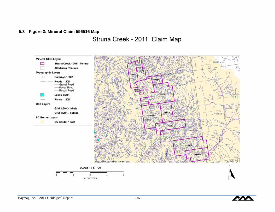
5.3 FIGURE 3: MINERAL CLAIM 596516 MAP ............................................................... 15
5.4 FIGURE 4: STRUNA CREEK DRILL SITE MAP............................................................ 16
5.5 FIGURE 5: STRUNA CREEK DRILL HOLES LOCATION MAP ............................................. 17
6 APPENDIX A – DDH ASSAY SHEETS ................................................ 18

Baymag Inc. – 2011 Geological Report - 1-
1 INTRODUCTION This report summarizes activities and results from exploration drilling program carried out by Baymag Inc. in August 2011. The program consisted of drilling, coring, logging, sampling and assaying 2 vertical (DDH 2011-03, DDH211-04, @-900) and 3 oblique (DDH2011-01A, DDH2011-02A, DDH2011-03A @-450) boreholes. The drilling was performed on the west slope of Mount Brussilof in close vicinity to Struna Creek, approximately 3.5 km south from Baymag Magnesite Open Mine (See Fig. 3). As a result of the drilling a total of 776.1 meters of core was recovered. Subsequently 470 samples were taken from the core for purpose of mineral and chemical evaluation. Execution of the program, along with all necessary field works (roads construction, sites preparation, equipment repositioning, sites reclamation) was performed by John Wolf Construction. Baymag Inc. personnel were responsible for the program’s design, coordination, field supervision, holes’ lay out, core logging, sampling and handling. Geochemical composition of the sampled core was determined through application of Induced Coupled Plasma (ICP) analyze, at the Baymag chemical lab in Exshaw, Alberta.
1.1 Location and Access The Struna Creek Exploration Site is located in the District of East Kootenay British Columbia, approximately 35 km north-east of Radium Hot Springs, in close proximity to confluence of Mitchell River and Assiniboine Creek (See Fig.1). It is crossed by latitude 50°47’N and longitude 115° 41’W and is situated within borders of the Mining Lease M31. Access to the Site is by Provincial Highway 93 from Radium Hot Springs northeast to Settlers Road in Kootenay National Park. The Road, which starts about 20 km of Radium, leads for 12 km south/southeast along the Valley of the Kootenay River. At the 12 kilometer mark Palliser Road branches off of the Settlers and continues through bridge on the Kootenay River for additional 2 km where it connects to Cross River Road at the 14 km junction. From the junction Cross Road follows the northeast direction along the south side of the Cross River Valley to a crossroad at 32 km. From this crossroad Mitchell River Road forks off and leads northward directly to the Baymag Mine. (See Fig. 1). In total the roads cover a distance of 38 km from the highway to the Mine Site and are maintained year round by Baymag Inc. Actual exit to the drill Site starts at 34.5 km of the Mitchell Road. From this exit , forestry road reconstructed by Baymag follows an uphill NE and E direction. The Site is in the distance of about 2.5 km from the exit, on approximate elevation of 1600 m.
1.2 Previous Work The Struna Property or Claim 596516 is one of 461 contiguous mineral titles registered in the Golden Mining Division by Baymag Inc. (See Fig. 2). In total, the claims cover a significant area of more than 10000 hectares of mainly mountainous and forested terrain. Exploration activities performed on the area has a long and rewarding history. They resulted in discovery of a world class magnesite deposit, which currently is mined and processed by Baymag Inc. The history started in 1966 when G.B. Leech of the Geological Survey of Canada who first discovered magnesite occurrence. Rock samples collected during the time upon chemical assaying showed high contents of MgO. The content was consistently reaching or exceeding 97% MgO level. Because of the Leech report, New Jersey Zinc Exploration Canada Ltd. staked the area and conducted a mapping and diamond drill program. Imperial Oil Enterprises also investigated the area but no additional work

Baymag Inc. – 2011 Geological Report - 2-
was performed. Baykal Minerals Ltd. conducted a mapping program in 1969, which resulted in acquisition of additional claims to bring the total to 278. Baykal Minerals arranged with New Jersey Zinc Exploration Canada Ltd. to conduct mining on their claims. Following the completion of fieldwork in 1969 to 1970, which included diamond-drilling programs, Acres Western Limited of Vancouver completed a production feasibility report for Baykal Minerals Ltd. During 1971 Brussilof Resources Limited and Baykal Minerals Ltd. amalgamated to form Baymag Mines Co. Limited. The property was optioned to Canadian Exploration Limited (CANEX) in 1972. CANEX conducted a field orientation program that included 2819.4 meters of diamond drilling to bring the total length then drilled on the property to 5,255 meters. Geological mapping of specific areas was also completed. In 1975, a 250 mt. bulk sample was shipped to Refratechnik, a major German producer of refractory products, which showed interest in securing a raw material source. Crushed material was then forwarded to the research and manufacturing companies of KHD, Lorgi and Polysius for research into developing a modern technology for calcining and dead-burning Mt. Brussilof type ore. In 1979 Baymag Mines Co. Limited - a subsidiary of Refratechnik GmbH of West Germany - contracted Techman and Kilborn Engineering (B.C.) Ltd to re-evaluate the feasibility of bringing the magnesite deposit into production. The evaluation involved surveys, 130 meters of percussion drilling, 75 meters of shallow diamond drilling and bulk sample extraction. A 100 ton sample of magnesite was extracted from a site on Rok 17 (now mine lease M31) and shipped to a crusher to be reduced to a minus 10 millimetres mesh. The crushed sample was then shipped to Nichols Engineering and Research in New Jersey to be dead burnt. The dead burnt material was briquetted for further testing. In 1981, Baymag entered into a contractual agreement with John Wolfe Construction Co. Ltd to operate the mine and to be responsible for ore supply to the production plant at Exshaw, Alberta, a facility leased from Canada Cement Lafarge. During 1984, eight exploration holes totalling a length of 731.5 meters of diamond drilling was completed on the Rok 17 claim. The core was descriptively logged, sampled and assayed. A major exploration program was conducted in 1987, the purpose of which was to investigate the extension of the known magnesite deposit up-slope from the current pit development and further delineate and evaluate the quality and quantity of the ore in the immediate vicinity of the active mining operations. Thirty-four diamond drill holes totalling 2707 meters were drilled, logged, sampled and assayed. A smaller exploration program was conducted in 1989 in two areas of the claim block. In the area proximal to the current mine development, the goal was to further delineate and evaluate the quality and quantity of ore immediately north of the known reserves. Fifteen shallow diamond drill holes totalling 273 meters were drilled, logged, sampled and assayed. The other area of interest was near the confluence of the Cross and Mitchell Rivers on the southern Vano claims (now Bay 19 & 21 claims). Ten shallow diamond drill holes totalling 110 meters were drilled, logged, sampled and assayed. The following year Baymag acquired new ground up the Alcantara, Assiniboine and Aurora Creeks bringing the total number of claims to 461 units. A small, percussion drilling program was conducted in 1990 with the goal of delineating zones of contamination near the little explored upper pit area. A total of 370 meters was drilled, sampled and assayed. It became evident that these localized contamination zones greatly influence the direction of pit development. Future drill and assay programs will be targeted toward these structures. Eight shallow percussion holes were drilled in the summer of 1991 to further delineate the zones of contamination in the north section of the upper pit. A total of 166 m were drilled, logged and assayed.

Baymag Inc. – 2011 Geological Report - 3-
A diamond-drilling program consisting of 16 holes was drilled in the summer of 1992. A total of 950 m was drilled, concentrated in an area immediately north of the upper pit. The program hoped to delineate new reserves and determine future pit development. A small exploration program was conducted in 1993 on the Bay-21 claim. Three diamond drill holes totalling 182 meters were drilled, logged, sampled and assayed. At the end of the 1993 exploration program, a total of 27 percussion holes and 145 diamond drill holes had been drilled on the property. This brings the total length of diamond drilling to 10,280 meters and percussion drilling to 500 meters. Commercial scale mining started in the second quarter of 1982 and has increased dramatically since then. The Mine is an open pit development and operates year round. Currently it produces in the order of 180,000 mt/year of high quality magnesite ore. The ore is subsequently transported to Baymag’s production facilities in Exshaw, Alberta where it is calcined into various grades of magnesium oxide (MgO). The calcined product is used in a wide variety of industrial, agricultural and environmental applications. Baymag produces several grades of MgO suitable for all of these purposes. The Struna Property was first explored by diamond drilling in 2009. Seven vertical holes, each of 100 m in depth, were drilled to evaluate mineral and geochemical makeup of the Site’s bedrock. No magnesite mineralization of economical or considerable scale was found as a result of the project. However, several geochemical results especially from holes: DDH2009-09, DDH2009-10 and DDH2009-11 clearly identified core sections of acceptable quality, equal to Baymag’s lower yet entirely usable ore grades. Subsequent to the 2009 program, in summer of 2010 several rock samples were collected from outcrops located above the 2009 drill site. Analytical research of the material returned surprisingly encouraging chemical results indicating on potential MgO enrichment. Following the finding, in summer of 2011 full scale exploration program followed. This report summarizes results of the program.
1.3 Geological Summary of Orebody
The genesis of the deposit is thought to be as mineralogical replacement or molecular substitution. As such, the process occurred when a fine-grained dolomite CaMg(CO3)2 was substituted by a coarse-crystalline magnesite MgCO3. The replacement, when taking place in geological past, likely included several phases of progressive influx of magnesium (Mg) rich fluids into existed dolomite sediment. On the molecular basis, the incursion resulted in a near complete removal of Ca+2 from chemical structure of the sediment and a fill up of available vacancies with Mg+2. The above chemical process was accompanied by a textural transformation, where original fine-grained layout of dolomite molecules was transposed into coarse-crystalline texture of newly formed magnesite. When viewed on a large scale the deposit is a relatively homogenous, high-grade orebody. Its appearance is well defined by a white to light-grey colour and remarkably evident crystalline texture of the magnesite rock. Closer examination, predominantly by chemical analysis, have identified that broad irregular zones of contaminants occur through such forms as veining, in-filling of fractures and within the magnesite matrix itself. The value of these contaminants and the form in which they occur play a key role in determining whether the material is considered as ore or waste. The components of vein material are generally fine-grained pyrite and/or aphanitic white dolomite. Veins occur as irregularly oriented structures with individual veins swelling to thickness of 10 cm and pinching out to nothing. Some veins, especially pyrite, tend to form in swarms covering areas tens of meters wide. In-filling of fractures occurs in thickness up to 5 cm and generally occurs as a light brown silty clay material, aphanitic white dolomite or as pyrite. Minor occurrences of palygorskite can sometimes be

Baymag Inc. – 2011 Geological Report - 4-
seen coating fracture walls. The fractures are generally narrow elongated curvy-planar structures with local deviations of strike and dip. An invisible chemical halo often brackets the more visible fracture. These halos pinch and swell in a similar manner as veining but on a larger scale. The interstitial or in-matrix contaminants are comprised of thin coatings of calcite or dolomite between magnesite crystals or as a simple Ca ion exchange within the crystal lattice itself. This form of contamination is the broadest form, covering areas as wide as 100 meters. With sufficient drilling, these areas can now be generally classified in the complimentary and marginal ore types, as contaminant values are usually less than occur in the other forms of contamination. The competitive market and specific end uses of magnesite, place a great importance on the chemical specification of the product. Somewhat unique to industrial minerals and magnesite in particular is the requirement of continually meeting a set grade specification without receiving any bonus for surpassing it. Material under spec on the other hand, has a very sharp value cut-off and is essentially valueless mere tenths of a percent below spec. Most, if not all naturally occurring deposits, rarely conform to such strict boundaries (e.g. some material within the deposit is above spec, some right at spec and some below.) As a result, before mining can be contemplated, a complex and feasible sequence of blending ore quality and ore type has to be determined. The Brussilof deposit is somewhat lucky in the respect that inverse grade relationship exists between various chemical zones of the ore-body. For example, when the ore has iron values above spec the calcium values are often consistently below spec and vice versa. Similar associations exist with other element pairs to a lesser degree. Baymag has initiated a complementary ore pile strategy in order to capitalize on this characteristic. Complimentary materials from different blasts are routinely blended together to achieve a uniform product exactly at the spec level thereby optimizing usage of the deposit. (A high iron, low calcium blast, which by itself would be waste, is blended with a low iron, high calcium which, again by itself would be waste, resulting in on-spec ore; in other words the right waste with its correct complimentary waste results in ore).
2 DETAILED TECHNICAL DATA AND INTERPRETATION
2.1 Purpose
The primary objective of the 2011 Exploration Program was a geological and geochemical valuation of claim 5965516 as a potentially viable source of magnesite ore. In the light of:
• 2009 exploration data, which from economic point of view showed somewhat encouraging data as to the claim’s mineral and geochemical composition, and
• 2010 field prospecting data, which in collected surface grab samples identified good chemical quality grades, the Program was undertaken to accumulate more geochemical data from subsurface horizons of the claim.
In particular, the Program’s explicit research targets were:
• A lateral (or any) extension of the Brussilof High Grade Magnesite orebody southward, past the limits of the current Mining Area, up to and on the Struna Property,
• Evaluation of subsurface geological, mineral and geochemical nature of the Site’s bedrock to a depth of hypothetical footwall (fine grained dolomite),
• Resolving if qualitatively promising ore grades and economically feasible tonnages of a magnesite occurred,
• Defining geological zones (if any) of potential interest including their spatial parameters, shapes, contacts, directions and trends,
• Resolving if the Claim has a future development capacity and as such should be held in reserve or as an economically unproductive could be given up.
Baymag Inc. – 2011 Geological Report - 5-
2.2 Methodology
Access road to the drilling area was constructed in July of 2011 in two phases: • phase 1: reactivation of 1850 m of disabled road, which originally was built in 2009 and used
for the implementation of that year Drilling Program. • phase 2: construction of a new road, from the end point of phase 1 directly to the 2011
projected drilling site. Length of the new road totaled in circa 700 m. For all ground work required to establish both roads a dozer CAT-D9 was utilized. Clearance of individual drill sites included tree removal and repositioning of overburden and glacial sediments, so that adequate exposure of the solid bedrock was accomplished. The actual drilling was commenced on August 4, 2009 and completed on August 21, 2009. A Longyear Model “34” (Stub Shaft with a Ford 172 Diesel engine) core rig was used to carry out the program. The unit was operated by a crew of two workers. Recovered from the drill holes core of 2.5 cm in diameter, was stored in core boxes in sequential segments of 4 sections by 5 feet long each. Successively, the core was split along its length with a 12” rock saw, and arranged for generic logging. The logging included description of most visually detectable features of the core, pertinent to its mineralogy, chemical compositions and physical state. In particular, in the charting focus of the core were: texture (whether crystalline or not), color, hardness, reactivity with HCl, inventory of main, accessory and traced minerals. Once logged, one half of the core from each 5 foot section was bagged, labeled and sent out for chemical assaying. At the same time, remaining core halves were safely stored in core shacks for future references if needed. The chemical assaying was performed by Baymag’s laboratory at the ore processing Plant in Exshaw, Alberta. It resulted in quantitative determination of MgO, CaO, Fe2O3, Al2O3, and SiO2 as major components of the researched material. Appendix 6 provides a complete set of chemical data obtained from the program. Immediately after completion of the drilling, full and thorough reclamation of the Site ensued. The reclamation, which was commenced on September 3 and completed on September 27, 2011 included:
• full reconstruction of all places, spots and sites disturbed by ground works to their original (or nearly original) state,
• even spreading of formerly piled up soil and overburden, • uniform scattering of biomass of non-merchantable timber, • grass-seeding of the entire area more or less effected by the project execution, • re-establishing the forestry road to its original state with all water-bars in place.
2.3 Data
DDH 2011-01A The hole was drilled from elevation of 1633.9 m down to 1532.0 m level, at the angle of -450 and azimuth of 900E. Crystalline carbonate of apparent and well developed “sparry” texture was prevailing lithological component in the hole. On average, crystal size of the texture ranged from 4 to 8 mm. The crystalline texture extended through the core length of 97.0 m from the initial elevation to depth of 1536.9 m. At the above level, a sharp textural change in core lithology occurred: a fine grained, thinly bedded, light to black dolomite replaced entirely the carbonate. Drilling of the hole was terminated at 1532 m when it became obvious that it was no longer within potentially MgO-hosting carbonate unit. Few color variations were quit noticeable in the researched rock material. The most perceptive was light-brow to brown, mottled pattern, which dominated through section from 8’ to 58’ and from 95’ to 205’ of the core length. This color, despite striking visual presence was in fact not associated with any uncommon mineral or abnormal level of analyzed components.

Baymag Inc. – 2011 Geological Report - 6-
In contrast, light gray stain - more typical for local magnesite mineralization - was common in the remaining part of the core. Based on analytical results and mineralogical observations, the following geochemical zones were identified in the hole:
1. From 1633.9 m to 1595.1 0 m zone of crystalline carbonate with consistent calcium content ranging 3-5% and averaging 5.25% CaO.
2. From 1633.9 m to 1595.1 0 m zone of crystalline carbonate with consistent calcium content ranging 3-5% and averaging 5.25% CaO.
3. From 1595.1 m to 1556.3 zone 26.8 m thick of crystalline carbonate averaging 95.27% MgO, 3.64% CaO, 0.68% Fe2O3, 0.11% Al2O3 and 0.30% SiO2.
4. From 1556.3 m down to 1536.9 m zone of crystalline carbonate averaging in: 88.67% MgO, 8.87% CaO, 2.24% Fe2O3, 0.06% Al2O3 and 0.15% SiO2.
5. From 1536.9 m to the hole’s and at 1532.0 m zone of fine grained dolomite. Due to obvious mineralogy, high reactivity with hydrochloric acid hydrochloric acid (HCl) and thus predictable high CaO composition, the section was not sampled.
Of special interest turned out to be the above selected middle section # 2. Characterized by an average 95.27% MgO content, the core section while not on the highest end of Baymag ore quality could definitely fulfill present day specifications of blendable ores. As such it was classified as economically feasible and considered as potential magnesite ore zone of 38.8 m in thickness. What's more, some of the chemical assays from the subject section showed remarkably low general and Fe2O3 in particular contamination levels. For instance, the segment between depth of 1572.5 and 1556.3m, with an average Fe2O3 value of only 0.55%, represented one of higher quality magnesite ore grades. The remaining two zones # 1 (overlaying) and # 2 (underlying) the section of possible ore, since significantly contaminated with overall CaO (zone 1) or CaO and Fe2O3 (zone 2), were excluded from further geochemical and economical consideration. DDH 2011-02A Location of this hole was in distance of 50 m south of the 2011-01A site. Started on elevation of 1639.6 m it also was drilled as an angled one at - 450 and azimuth of 900E. Total length of recovered core amounted in 112.3 meters. The drilling was terminated at the depth of 1527.3 m after earlier interception (depth of 1535.1 m) of a lithological horizon of fine grained dolomite and advancing through the formation for another 7.8 m. The uppermost part of the core of 8.6 m in length (from 1639.6 m to 1631.0 m) showed relatively clear physical features of a typical caprock: high brittleness, softness, brown to rusty discoloration and intense fracturing. Resulted from rather weathered state and additionally contaminated by CaO (frequent white dolomite crystals up to 6 cm in diameter) and Fe2O3 (commonly scattered Pyrite veins and clusters) the section not surprisingly showed no MgO enrichment averaging in only 89.56% MgO content. From 1631 m to 1627.7 m the hole intersected a layer of dark gray to black, thinly bedded, fine grained dolomite. It was detected that in this upper lithological division, both the carbonate and the dolomite units were characterized by fairly low overall Fe2O3 values, averaging in only 0.81% of the oxide. These two zones of low Fe2O3 content were reported in a drastic mineralogical contrast with underlying core section of 10.8 m in thickness (elevation 1625.6 m to 1614.8 m). Pyrite veins of irregular orientation and size as well as small (1-3 mm) Pyrite clusters and clots, were identified in the section in high number. In all, averaged iron oxide level was reported as 1.21% of Fe2O3. Significantly higher level of Pyrite contamination was recognized in the hole’s bottom part at the depth from 1548.0 m to 1530.8m (18.8 m total thickness). Averaging in 1.96% of Fe2O3 the section was saturated with Pyrite occurrences, usually in form of 1 - 4 mm thick veins and irregular clusters. In a few extreme cases size of some Pyrite crystals was in range from 3 to 4 cm in diameter. These rather anomalous concentrations were well reflected by high analytical results reaching double digit values (e.g. Value: 13.64% Fe2O3 in sample # 144886 at depth from 1545.8 m to 1544.8 m).

Baymag Inc. – 2011 Geological Report - 7-
Chemical assays from core cut between elevation of 1614.8 m and 1548.0 m, indicated on low yet to a certain extent encouraging rock quality. Whereas the MgO contents averaged 93.18%, other major oxides were reported as follows: 5.39% CaO, 0.79% Fe2O3, 0.15% Al2O3, and 0.48% SiO2. Elevated to high yet very tight and homogenous ranges of all analyzed oxide components were remarkable feature recognized in this section of the core. From visual point of view it also represented very solid and consistent physical state with minimum or no fracturing and any weathering or erosion/leaching/dissolving signs. DDH 2011-03 and DDH 2011-03A Drill site for the above two holes was designed 50 m further south of DDH 2011-02A. While both holes were started in the same spot on collar elevation of 1624.5 m, the DDH 2011-03 was drilled at - 900
dip, whereas DDH 2011-03A at - 450 and azimuth of 900E. Due to the above vertical/angled setting of the holes, the drilling was progressing mainly through identical or very similar lithological units. In general, crystalline (sparry) carbonate formation was identified in both holes extending from the collar elevation down to 1519.3 m level (vertical hole) and 1508.1 m (angled hole). Below these levels, a fine grained dolomite with perfect thin layering of light and dark strata ensued. Based on chemical data derived from samples of the crystalline formation, the following sequence of 3 main mineralogical units was clearly identified and distinguished:
1. Siliceous sparry carbonate: depth intervals: 1618.4 m – 1583.4 m in hole DDH 2011-03 and 1622.3 m – 1601.9 m subsequently in hole DDH 2011-03A. On average contents of individual oxides in the intervals were close to the following: 90.00% MgO, 5.7% CaO, 1.45% Fe2O3, 0.11% Al2O3, and 1.90% SiO2.
2. Sparry carbonate: depth intervals: 1571.2 m – 1519.3 m in hole DDH 2011-03 and 1574.9 m – 1535.1 m subsequently in hole DDH 2011-03A. On average contents of individual oxides in the intervals were close to the following: 89.44% MgO, 8.81% CaO, 1.00% Fe2O3, 0.15% Al2O3, and 0.59% SiO2.
3. Sparry dolomitic carbonate: depth intervals: 1519.3 m – 1495.0 m in hole DDH 2011-03 and 1535.1m – 1512.4 m subsequently in hole DDH 2011-03A. On average contents of individual oxides in the intervals were close to the following: 84.18% MgO, 13.84% CaO, 1.64% Fe2O3, 0.08% Al2O3, and 0.26% SiO2.
In the light of the above data, no MgO mineralization of economic value was identified in any of the above three units. The fine grained dolomite, which as mentioned above in both holes underlined the sparry complex, was clearly defined by high CaO contamination averaging 36.00% (rather normal level for this mineral kind) and very low MgO contents of only 63.26%. Analyses of the remaining oxide constituents were reported as follows: 0.38% Fe2O3, 0.11% Al2O3, and 0.26% SiO2 DDH 2011 - 04 The hole was located on the southern side of the Struna Creek deep canyon and drilled vertically at - 900. Started on elevation of 1637.0 m it was terminated at depth of 1510.5 m after recovering 126.5 meters of core. Lithology of the core was similar to what had been previously identified in other holes. It again consisted of two mineral groups: top (from 1637.5 m to 1576.5 m, thickness of 61.0 m), overlying sparry carbonate and bottom (from 1576.5 m to 1511.0 m, thickness of 65.5 m) underlying fine grained dolomite. Border between the two unites was quite sharp and consisted of an abrupt change in texture size and even more in chemical composition. In general, the following averages were calculated from 81 core sample assays for the above lithological units:
• Crystalline carbonate: MgO 87.70%, CaO 11.00%, Fe2O3 1.10%, Al2O3 0.10%, and SiO2 0.19%. (in fact core section of 27.4 m thick, between elevation 1631.4 m and 1604 m contained somewhat better quality of: MgO 92.24 %, CaO 6.84 %, Fe2O3 0.67 %, Al2O3 0.08%, and SiO2 0.18%).
• Dolomite: MgO 54.04 %, CaO 44.68 %, Fe2O3 0.92 %, Al2O3 0.13%, and SiO2 0.22%.

Baymag Inc. – 2011 Geological Report - 8-
Pyrite mineralization in form of thick, irregular and randomly oriented veins was present independently on lithological nature of the core. Highest Pyrite concentrations were recognized especially between depth interval of 1596.4 and 1579.6 m (carbonate unit) as well as 1570.4 and 1561.3 m. Analytical readings of Fe2O3 in these intervals ranged from values as low as 0.80% to as high as 4.71%.
2.4 Conclusions
• In spite of close proximity (3-4 km) to the Brussilof High Grade Magnesite Deposit the Program - except of a few individual chemical data - showed no geochemical evidence for existence of a large tonnage/high grade magnesite mineralisation within the borders of Struna Creek Mineral Claim.
• The program confirmed only horizontal extension of lithologically crystalline (sparry) carbonate formation, which hosts the Brussilof Magnesite Orebody.
• Only in hole 2011 – 01A in core section of 16.2 m in length (from elevation of 1572.5 m to 1556.3 m), the identified composition was narrowly adequate (96.13% MgO, 3.04% CaO, 0.54% Fe2O3, 0.08% Al2O3, 0.22% SiO2) to current ore specifications. Otherwise, analytical data obtained from the drill holes failed to recognize any geological zones of potential value as high grade magnesite ore resource.
• In hole 2011 – 01A and 2011 – 02A zones of considerable thickness (58.1 m in hole 2011 – 01A from elevation of 1631.7 to 1573.6 and 65.7 m in hole 2011 – 02A, from elevation of 1613.7 m to 1548.0 m) and chemical homogeneity yet lower grade magnesite were identified.
• Sequential lithological pattern, consisted of crystalline, sparry carbonates overlaying non-crystalline, stratified dolomite rocks, was identified in all 5 holes.
• Visually recognised mineral phases included various forms of dolomite, pyrite, limonite, palygorskite and quartz. If analysed on more detailed, microscopic scale the researched core would have likely generated more mineral findings.

Baymag Inc. – 2011 Geological Report - 9-
3 ITEMIZED COST STATEMENT The total costs incurred during the 2011 (from August - September 2011) for diamond drilling program were as follows:

Baymag Inc. – 2011 Geological Report - 10-

Baymag Inc. – 2011 Geological Report - 11-
Baymag Inc. – 2011 Geological Report - 12-
4 AUTHORS’ QUALIFICATIONS Program supervision: Ian Knuckey, MBA, B. Sc. Geology, Mine Manager Report compilation, geological interpretation, conclusions: Chris Pilarski, M.Sc. Geology, Senior Mine Geologist .

Baymag Inc. – 2011 Geological Report - 13 -
5 Figures
5.1 Figure 1: Regional Location Map

Baymag Inc. – 2011 Geological Report - 14 -
5.2 Figure 2: Baymag Claims Map
Baymag Inc. – 2011 Geological Report - 15 -
5.3 Figure 3: Mineral Claim 596516 Map

Baymag Inc. – 2011 Geological Report - 16 -
5.4 Figure 4: Struna Creek Drill Site Map

Baymag Inc. – 2011 Geological Report - 17 -
5.5 Figure 5: Struna Creek Drill Holes Location Map General Area and Access to Tenure # 596516 Close-up of the Drill Sites

Baymag Inc. – 2011 Geological Report - 18 -
6 APPENDIX A – DDH Assay Sheets
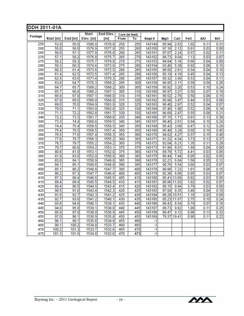
Baymag Inc. – 2011 Geological Report - 19 -

Baymag Inc. – 2011 Geological Report - 20 -

Baymag Inc. – 2011 Geological Report - 21 -

Baymag Inc. – 2011 Geological Report - 22 -

Baymag Inc. – 2011 Geological Report - 23 -

Baymag Inc. – 2011 Geological Report - 24 -

Baymag Inc. – 2011 Geological Report - 25 -

Baymag Inc. – 2011 Geological Report - 26 -

Baymag Inc. – 2011 Geological Report - 27 -


