SITE ASSESSMENT JBA Job number: 2011s5232 Job Title: North-West & Neagh-Bann CFRAM Sheet number: 1 of 4 Site Name: DUNFANAGHY UM Approval: Ross Bryant JBA Consulting www.jbaconsulting.ie 2011s5232-Site Assessment - Dunfanaghy Name: Dunfanaghy County: Donegal HA: 38 Unique ID: 385338 Source of Flooding (Fluvial / Tidal): Fluvial / Tidal Type: AFA Visit By: Rosalie Scanlon Date of Visit: 10/09/2011 PFRA Data / Comments (taken from 110310_Final Database): Predictive assessment indicates potentially significant flood risk exists (FRI Total > 250). No strong evidence against inclusion as an AFA Approved AFA PFRA Database Comments (taken from 110309_ALL_VAL - Post Round Two - MA.mdb): OPW comments No comment in database LA comments Lands between Dunfanaghy and Portnablagh are liable to flood. High Tides could be a problem. LA Around town square in 1 in 8 year high tide Watercourses / Sources of Flooding: Tidal flooding along the sea front is the primary source; there is the potential for fluvial flooding from the Dunfanaghy watercourse (located to the east of the town) but this was not included in the fluvial model output and therefore does not feature in the FRI score. Maps: See Flood Risk Review Site Map below. Flood Outlines and Receptors: Dunfanaghy received an overall PFRA score of 597. This is based on tidal flood risk. The scoring breakdown in presented in the following table: Flood Risk Receptor FRI Score Name Dunfanaghy TOTAL_TIDAL 596.91 Res_tot_prob_T_S 522.51 Com_tot_prob_T_C 60.97 OPW_MV_Weighted_T_S 3.43 Total FRI Score 596.91 The majority of the score, 522.51, is for residential properties at tidal flood risk. This score was based on a simplified coastal flood map. Since this PFRA score was determined more advanced modelling was completed under the ICPSS. With this more detailed flood map and the benefit of the site visit, the PFRA score can be reduced; this is discussed in more detail below under Site Visit Findings. Comment on Flood Outlines: The OPW coastal flood mapping shows a number of dwellings that are at tidal flood risk in Dunfanaghy town. There is a government building (Dunfanaghy Social Welfare Office) in the predicted flood outline. The Dunfanaghy watercourse does not appear to have been modelled and does not have a PFRA flood outline associated with it. An approximate estimation of the potential flood risk to a number of houses on the left bank has been digitised and is presented under Site Visit Findings.
Name: Dunfanaghy County: Donegal HA: 38 Unique ID: 385338Source of Flooding (Fluvial / Tidal): Fluvial / Tidal Type: AFAVisit By: Rosalie Scanlon Date of Visit: 10/09/2011PFRA Data / Comments (taken from 110310_Final Database):Predictive assessment indicates potentially significant flood risk exists (FRI Total > 250). No strongevidence against inclusion as an AFAApproved � AFA
PFRA Database Comments (taken from 110309_ALL_VAL - Post Round Two - MA.mdb):OPW commentsNo comment in database
LA commentsLands between Dunfanaghy and Portnablagh are liable to flood. High Tidescould be a problem. LA Around town square in 1 in 8 year high tide
Watercourses / Sources of Flooding:Tidal flooding along the sea front is the primary source; there is the potential for fluvial flooding from theDunfanaghy watercourse (located to the east of the town) but this was not included in the fluvial modeloutput and therefore does not feature in the FRI score.
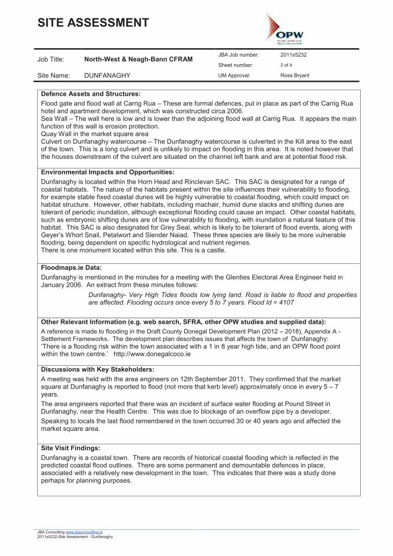
Maps:See Flood Risk Review Site Map below.
Flood Outlines and Receptors:Dunfanaghy received an overall PFRA score of 597. This is based on tidal flood risk. The scoringbreakdown in presented in the following table:
The majority of the score, 522.51, is for residential properties at tidal flood risk. This score was based on asimplified coastal flood map. Since this PFRA score was determined more advanced modelling wascompleted under the ICPSS. With this more detailed flood map and the benefit of the site visit, the PFRAscore can be reduced; this is discussed in more detail below under Site Visit Findings.
Comment on Flood Outlines:The OPW coastal flood mapping shows a number of dwellings that are at tidal flood risk in Dunfanaghytown.There is a government building (Dunfanaghy Social Welfare Office) in the predicted flood outline.The Dunfanaghy watercourse does not appear to have been modelled and does not have a PFRA floodoutline associated with it. An approximate estimation of the potential flood risk to a number of houses onthe left bank has been digitised and is presented under Site Visit Findings.
Defence Assets and Structures:Flood gate and flood wall at Carrig Rua � These are formal defences, put in place as part of the Carrig Ruahotel and apartment development, which was constructed circa 2006.Sea Wall � The wall here is low and is lower than the adjoining flood wall at Carrig Rua. It appears the mainfunction of this wall is erosion protection.Quay Wall in the market square areaCulvert on Dunfanaghy watercourse � The Dunfanaghy watercourse is culverted in the Kill area to the eastof the town. This is a long culvert and is unlikely to impact on flooding in this area. It is noted however thatthe houses downstream of the culvert are situated on the channel left bank and are at potential flood risk.
Environmental Impacts and Opportunities:Dunfanaghy is located within the Horn Head and Rinclevan SAC. This SAC is designated for a range ofcoastal habitats. The nature of the habitats present within the site influences their vulnerability to flooding,for example stable fixed coastal dunes will be highly vulnerable to coastal flooding, which could impact onhabitat structure. However, other habitats, including machair, humid dune slacks and shifting dunes aretolerant of periodic inundation, although exceptional flooding could cause an impact. Other coastal habitats,such as embryonic shifting dunes are of low vulnerability to flooding, with inundation a natural feature of thishabitat. This SAC is also designated for Grey Seal, which is likely to be tolerant of flood events, along withGeyer�s Whorl Snail, Petalwort and Slender Naiad. These three species are likely to be more vulnerableflooding, being dependent on specific hydrological and nutrient regimes.There is one monument located within this site. This is a castle.
Floodmaps.ie Data:Dunfanaghy is mentioned in the minutes for a meeting with the Glenties Electoral Area Engineer held inJanuary 2006. An extract from these minutes follows:
ÿ Dunfanaghy- Very High Tides floods low lying land. Road is liable to flood and propertiesare affected. Flooding occurs once every 5 to 7 years. Flood Id = 4107
Other Relevant Information (e.g. web search, SFRA, other OPW studies and supplied data):A reference is made to flooding in the Draft County Donegal Development Plan (2012 � 2018), Appendix A -Settlement Frameworks. The development plan describes issues that affects the town of Dunfanaghy:�There is a flooding risk within the town associated with a 1 in 8 year high tide, and an OPW flood pointwithin the town centre.� http://www.donegalcoco.ie
Discussions with Key Stakeholders:A meeting was held with the area engineers on 12th September 2011. They confirmed that the marketsquare at Dunfanaghy is reported to flood (not more that kerb level) approximately once in every 5 � 7years.The area engineers reported that there was an incident of surface water flooding at Pound Street inDunfanaghy, near the Health Centre. This was due to blockage of an overflow pipe by a developer.Speaking to locals the last flood remembered in the town occurred 30 or 40 years ago and affected themarket square area.
Site Visit Findings:Dunfanaghy is a coastal town. There are records of historical coastal flooding which is reflected in thepredicted coastal flood outlines. There are some permanent and demountable defences in place,associated with a relatively new development in the town. This indicates that there was a study doneperhaps for planning purposes.
Based on the PFRA score there are at least 52 residential and 6 commercial properties at risk. The PFRAused a simplified method to interpolate tide levels and estimate coastal flooding in the North-West region, asthe final outputs from the ICPSS were not available for this section of the Irish coast. Using the morerefined and detailed coastal mapping from ICPSS, the number of buildings shown within the PFRA outlinesis less than half this at 21. It is considered appropriate to reduce the score, in light of this more detailedflood mapping and based on the site visit findings. It is noted that the Carrig Rua hotel and apartmentcomplex is counted as one building. Considering a total number of 21 properties at flood risk in a 10% AEPflood event will generate a score of 210 points.There are a number of houses on the banks of the Dunfanaghy watercourse (which are not shown in thePFRA predicted flood outline). These may be at flood risk, particularly those on the left bank immediatelydownstream of the culvert crossing on the main road. These houses are shown in the photos below and inthe map (showing the revised flood outline) that follows.
Photo 3 � House on Left Bank Photo 4 � Dunfanaghy Watercourse
Out of bank flow here could add up to 5 houses which based on a 1% AEP would increase the overall scoreby 5 points. The stream is culverted upstream of this point and it was unclear on site where the upstreamend of the culvert is located. An indicative extreme flood outline to include for the potential risk to thesehouses from this watercourse is shown below.
Summary:Based on the ICPSS outlines and site visit there are approximately 20 properties at risk in a 10% AEP eventand 5 properties potentially at risk from a 1% fluvial event, giving this FRR site a score of 205. This is belowthe threshold and it is considered appropriate following the flood risk review stage not to bring this siteforward for further assessment.
Name: Dungloe County: Donegal HA: 38 Unique ID: 385339Source of Flooding (Fluvial / Tidal): Fluvial / Tidal Type: Risk ReviewVisit By: Rosalie Scanlon Date of Visit: 10/09/11PFRA Data / Comments (taken from 110310_Final Database):Local knowledge indicates risk, but not supported by the predictive or historic assessments. It is notdeemed appropriate to define this area as being at potentially significant risk
PFRA Database Comments (taken from 110309_ALL_VAL - Post Round Two - MA.mdb):OPW commentsTidal and fluvial flooding
LA commentsWhen river is high flood backup at PSC. Lack of any drainage at sections of Quay Road
Flooding Source:Fluvial flooding from Dunglow River and tidal flood risk. (Note that in this report the river is referred to asDunglow River, rather than Dungloe River, as defined on the OS mapping)Hydrometric Station: There is an inactive hydrometric station located downstream of the bridge by thehospital.
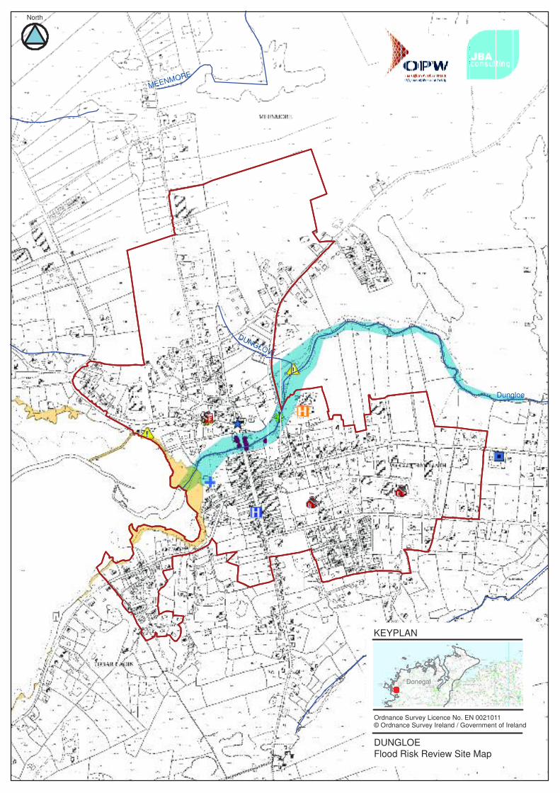
Maps:See Flood Risk Review Site Map below.
Flood Outlines and Receptors:The PFRA outlines show some coastal flooding at the mouth of the river and fluvial flooding over the riverbanks. In the PFRA flood outline there are a number of residential / commercial buildings. Dungloe wasnot included in the PFRA scoring spreadsheet.
Comment on Flood Outlines:The PFRA flood outlines appear reasonable; however the outlines were extended in the vicinity of thehospital to include for the potential risk to the hospital due to blockage of the bridge on Gweedore Road andto reflect historic accounts of flooding. This amended outline is discussed in more detail under the sectionbelow on Site Visit Findings. The existence of a water pool just upstream of the weir and sluice adjacent tothe hospital is not reflected in the PFRA outlines.
Defence Assets and Structures:Sluice and weir � located adjacent to Dungloe community hospital; maintains water level upstream of thispoint and regulates downstream flow.There is a second weir mapped at the mouth of the river, however this was not visible on the day of the sitevisit.Gweedore N56 Road Bridge � located just downstream of the hospital site; blockage here has potential tocause backing up and impact flooding at the hospital.R259 Road Bridge � this is in a built up area with commercial properties on all sides. Some properties areerected on stilts over the river channel at this bridge. A blockage here has the potential to impact onflooding in this area.
Environmental Impacts and Opportunities:There are no designated sites of nature conservation interest located within, or in close proximity, toDungloe.There are no historic monuments/features located within, or in close proximity, to this site.
Dungloe River and lakes are part of the Rosses Fishery and there is a fish monitoring point / counter at thesluice and weir located adjacent to Gweedore Road and the Hospital.
Floodmaps.ie Data:The following is an extract from the Glenties Electoral Engineer Meeting Minutes take took place in January2006:
ÿ Dungloe 1 - High Tides once or twice a year floods low lying land. Road is liable to flood andproperties may be affected. Flood Id = 4115
ÿ Drummeen, Dungloe � A combination of river overflowing its banks and lake level rising causeflooding every year after heavy rain. Flood Id = 4116
ÿ Dungloe 2- River Dungloe overflows its banks after heavy rain every year. The road is liableto flood occasionally. Flood Id = 4117
Other Relevant Information (e.g. web search, SFRA, other OPW studies and supplied data):No other information was found relating to flooding in this area.
Discussions with Key Stakeholders:A meeting was held with the area engineers on 12th September 2011 and the following lists the issueshighlighted:
ÿ There are major issues with surface water flooding in the vicinity of the Dungloe PublicService Centre and Fire Station. The car parking areas are frequently under water. This areahas flooded 6 or more times in the last 2 years. A watercourse is culverted under a newdevelopment site and along by the PSC and fire station sites. This watercourse discharges ata low level upstream of the sluice on the Dunglow River.
ÿ There are inadequately sized surface water drainage pipes along the Gweedore roadadjacent to the hospital.
ÿ There have been a number of floods at the Hospital preventing cars gaining access.ÿ There are surface water flooding issues at Mc Devitts service station on the Mill Road.ÿ It was commented that recent development in Dungloe town is draining into already
inadequate surface water drainage networks.ÿ The 2 schools that serve the Dungloe area are located on Chapel Road.
Key Contacts (local authority, local or community groups):Dungloe Electoral Area, Donegal County Council
Name Position Tel Mobile EmailBrendanMcFadden
Area Manager, SeniorExecutive Engineer(Roads Section)
The Secretary, Rosses Angling Association, Dungloe, Co. Donegal
Site Visit Findings:The Dunglow River runs through the town before it enters the sea. The LA highlighted issues with surfacewater flooding in the town near the PSC, fire station and hospital.The Gweedore Road Bridge is located in this area and is immediately downstream of the hospital. Thereare houses located on the left bank downstream with back gardens extending out to the river bank edgeand the Bayview Bar car park extends to the river edge on the right bank. There is a sluice and weirupstream, which include a fish counting monitor. The hospital grounds have been known to flood and in
recent years the ambulance was used to bring visitors to the hospital, such was the depth of flooding on theroad. The majority of the reported flooding here has been due to surface water drainage problems,however the proximity of the hospital to the river and its location immediately upstream of a flow structuremeans that there is a fluvial flood risk to the hospital and its grounds. The hospital is of critical vulnerabilityand if flooded in a 1% AEP will attract a FRI score of 2500.
Photo 1 � Dunglow River Photo 2 � Bayview Bar Car Park
Photo 3 � Culvert looking US Photo 4 � Hospital with Dunglow River in foreground
Photo 5 � US face of Culvert Photo 6 � Hospital on river bank
Photo 7 � Fisheries Monitoring Point, sluice and weir
Surface water drainage from the road and hard standing areas in the PSC and fire station area dischargeinto the Dunglow River upstream of the sluice and it was reported by the LA that this outlet is at a low level.There is a second flow structure on the main street; this is the R259 Road bridge. Buildings here havebeen built on stilts over the river channel.
There is a wastewater treatment plant located downstream that is adjacent to but not within the PFRAoutline. The topography of the land here is flat and so it is difficult to say from the site visit whether thisWWTP is at flood risk or not. It is shown outside of the PFRA flood outlines. Including this will as a riskreceptor in a 1% AEP event will add 2.5 points to the FRI score.
Photo 10 � WWTP Photo 11 � Flat Topography at river mouth
Based on the site visit the PFRA flood outlines have been amended to account for the potential risk at thehospital and the WWTP. The adjusted outlines are presented below:
OSi Licence No. EN 0021011
Recommended Extreme Flood Outline
The number of buildings at potential flood risk is 14; the associated score assuming these are at risk in a1% AEP is 14.Adding the FRI score of these receptors, gives a total FRI score of 2516.5.
Summary:Following the site visit, the Dungloe Community hospital is identified as a key receptor, which is of criticalvulnerability. The WWTP and a number of houses were also identified as receptors. Calculation of the FRIbased on these receptors gives Dungloe an overall FRI score of 2516.5 which is well above the thresholdfor inclusion as an AFA.The surface water drainage network, particularly on Gweedore Road is reported to be severely under
Name: Glenties County: Donegal HA: 38 Unique ID: 385347Source of Flooding (Fluvial / Tidal): Fluvial Type: AFAVisit By: Mairéad Conlon Date of Visit: 06\09\2011PFRA Data / Comments:PFRA Data / Comments (taken from 110310_Final Database):Predictive assessment indicates potentially significant flood risk exists (FRI Total > 250). No strongevidence against inclusion as an AFA.
PFRA Database Comments (taken from 110309_ALL_VAL - Post Round Two - MA.mdb):OPW commentsRoad flooding
LA commentsTopography of town and River Owenea and large catchment combine to increase flood risk Crossingrequired on Main Street. Crossing on R250 required. Crossing at Meenahalla.
Watercourses / Flood Sources:Fluvial sources from the Gortnamucklagh River, the Stracashel River and the Owenea River.
Maps:See Flood Risk Review Site Map below.
Flood Outlines and Receptors:The total FRI score for Glenties is 361.5. Predominantly the receptors are all residential and commercialproperties. The total PFRA breakdown is shown in the table below. The 10% AEP and the 100% AEP floodoutlines are similar with most of the receptors in the 10% AEP outline.
Comments on Flood Outlines:The PFRA outlines have been applied to all watercourses in the area. They seem to be correct andcorrespond to the records available and site visit (see below).
Defence Assets and Structures:There is one large bridge in the centre of the town on the Stracashel River. The bridge seems appropriatelysized for the river.
Environmental Impacts & Opportunities:This AFA is located on the Owenea River and Stracashel River which are both designated as part of theWest of Ardara/Maas Road SAC and pNHA. Several of the species for which this site is designated a SACmay be present, including Freshwater Pearl Mussel, Salmon and Otter. These species may be adverselyaffected by flooding and flood risk management activity, particularly during their breeding seasons, throughdisturbance to spawning gravels or flooding of holts.Lough Nillan Bog SPA is also located in close proximity to the Owenea River. This site is designated for itsoligotrophic water habitats and blanket bog. These habitats are wetlands and tolerant of periodic
inundation, however, extreme events which impact on nutrient status or sediment loadings may have anadverse impact.There is one monument located within this AFA. This is a standing stone.
Floodmaps.ie Data:
There is one flood point in the development boundary and one to the south west of the town, downstream ofwhere the Gortnamucklagh River flows into the Owenea River.
A report from a Donegal County Council meeting in 2006 mentions flooding in the Glen of Glenties roadwhich is not shown to be affected by flooding in the PFRA outlines.
Glenties R253 Glen of Glenties road � frequent.Part of road raised slightly
Glenties Owenea River flood plain � frequent
Discussion with Key Stakeholders:A meeting was held with the area engineers of the Dungloe electoral area. It was noted at this meeting thatthe Mully Road, approximately 3km east of Glenties is often impassable due to flooding.
Key Contacts (local authority, local or community groups):Dungloe Electoral Area, Donegal County Council
Name Position Tel Mobile EmailBrendanMcFadden
Area Manager, SeniorExecutive Engineer(Roads Section)
During the site visit, conversations with locals were held to ascertain the extent of any flooding which mayhave occurred in the past few years. It was found that the back garden of one household, which regularlyfloods, flooded one week prior to the site visit. This is outlined in the Site Visit Findings section below.
Site Visit Findings:On the site visit there was no evidence found to exclude any of the properties from the flood outlines.A few days prior to the site visit the river had flooded a back-garden of a private resident adjacent to theCourt House. Speaking to the residents, this type of event happens once every few years. The extent of therecent flooding matches that of 1% AEP PFRA outline. However the residents spoke of flooding to a higherlevel on one occasion over 15 years ago. Therefore it is suspected that the 1% AEP outline may beunderestimated in this area.
SummaryThe risk of fluvial flooding in Glenties town is posed mainly from the Stracashel River, which flows into theOwenea River outside the town and from a lesser extent by the Owenea River.
With the initial FRI score of 361.5, together with the supporting assessment herein, Glenties should remainas an AFA. There was no evidence to warrant reduction of the FRI score below the threshold level of 250.
Final FRR Status: AFA
Backyard which frequently floods. Floodoutlines amended according to historicalevidence.
Name: Inver County: Donegal HA: 37 Unique ID: 370583Source of Flooding (Fluvial / Tidal): Fluvial/ /Tidal Type: Risk ReviewVisit By: John Daly Date of Visit: 30/08//2011PFRA Data / Comments (taken from 110310_Final Database):Predictive assessment indicates potentially significant flood risk exists (FRI Total > 250). No strongevidence against inclusion as an AFAProbable error in predictive flood extent - Risk Review - Not an AFA
PFRA Database Comments (taken from 110309_ALL_VAL - Post Round Two - MA.mdb):OPW commentsSluice required. Original comment related to INVER GLEBELA commentsNo comment in database
Watercourses/Sources of Flooding:Predominantly the flood sources in the area are a mix of fluvial and tidal however the PFRA flood extents donot fully cover the River Inver estuary. The other watercourses in the area are the Mullanboys, Drumduffand Keeloges streams.
Maps:See Flood Risk Review Site Map below.
Flood Outlines and Receptors:The total FRI score of 261 in the PFRA for the site is over the threshold of 250 for AFA status. The TotalTidal FRI score of 121.97 is not reflected in the predicted outlines showing a smaller risk of tidal flooding(FRI <20). This is due to the fact that the PFRA tidal FRI score was calculated based on a simplified coastalflood map. Since this PFRA work was completed more detailed coastal flood mapping has been producedunder the ICPSS which indicates a more refined coastal flood risk. The initial tidal score should be editedinline with the ICPSS coastal flood map and to reflect the findings of the site visit.The majority of the total FRI score is made up of fluvial and tidal flood risk to residential properties. Thepredicted outlines for the fluvial 1% AEP event is very similar to that of the 10% AEP. The receptors arescored based on flood risk in the 10% AEP event.No receptors of high vulnerability are within or adjacent to the flood extents.
Comment on Flood Outlines:The PFRA fluvial outlines show a number of properties to the east of Inver (left bank) at risk however thereis not any history of flooding here. The PRFA outlines appear to overestimate the flood extent, there is a
�spike� in the outline and this has been commented on previously �Probable error in predictive flood extent�.The PFRA outlines have been amended based on the site visit walkover and the topography of the site.The Recommended Extreme Flood Outline is presented in the Site Visit Findings section.
Defence Assets and Structures:There are coastal defences and a large bridge in this area. The historic data mentions a flood wall/possibleerection of a sluice gate as a defensive feature in 1999, but this was not identified during the site visit.The coastal defences found include:
ÿ A 150m retaining wall with no parapet as shown in Photograph 2. On the day of the visit avegetated shingle bank was noted along much of the toe of the structure. The vegetation indicatesstability and relatively mild wave conditions. The aging wall was found to be settling in locations andwas not designed for flood defence.
ÿ The earth embankment was found to be 200m long and 4m high with gabion baskets and rockprotection on the most exposed part near the Quay. The embankment showed signs of erosion inplaces and was possibly constructed as a means of erosion protection with the benefit of some tidalflood defence (see photos below). The residents of the Quay area have acknowledged that itspresence has reduced the affects of tidal flooding.
ÿ A 70m long Quay wall is also constructed in the coastal village but was not designed to protectagainst flooding.
Environmental Impacts & Opportunities:There are no designated sites of nature conservation interest within, or located in close proximity, to thissite.There are five monuments located around Inver, including a church, cist and an enclosure.
Floodmaps.ie Data:Two reports of describing limited flooding in Inver from a combination of fluvial and tidal sources:
OPW memos of tidal flooding: Report Flooding at Inver 05/May/1999 3 OPW memo with photos. Deals withflooding at Inver Co Donegal. (Report Includes: No. of Properties Damaged (1), Source, Cause)
Donegal Electoral Engineer � Minutes 2006Minutes of meeting identifying areas subject to flooding - Donegal Report Includes: Source, Cause
ÿ D2.Inver � River overflows its banks once or twice every year through a combination of heavy rainand high tides. Road is liable to flood and properties are affected. Flood Id = 4144
Discussions with Key Stakeholders:Ross Bryant and John Daly of JBA Consulting met with Peadar Thomas (Senior Executive Engineer) andDeclan Gillespie (Area Engineer) on 30th August 2011.
ÿ No knowledge of flooding in Inver
Key Contacts (local authority, local or community groups):Name Position Email Tel MobileDeclan Gillespie Area Engineer 087 987 9130
The site visit found there is local knowledge of tidal flooding near the village/quay area of Inver; theconstructed defences have mitigated some smaller events. Large events during the spring tide are known tohave caused property damage in past. An event in 1973 was highlighted, by local residents, to have causeddamage to a number of properties however the return period is unknown.
Other Relevant Information:No other relevant data was found relating to flooding in this area.
Site Visit Findings:The school and sports pitches have been raised substantially enough to reduce risk of flooding. Thedistance to watercourse is large (~40m) and from the site visits the building was confirmed to be outside thePFRA 1% AEP Extents.
School with raised pitches Some of the properties possible at risk fromtidal flooding
The site visit and consultation with residents of Inver highlighted a coastal area that has historically (1973and 1999) had issues with tidal flooding. This was not shown in the initial 0.5% AEP outlines did not containthese properties. Coastal defences are present but erosion and rare cases of overtopping (Stillwater onSpring Tide) suggest a risk of flooding to a maximum of 20 properties, this is greater number thansuggested by the initial IPCSS tidal flood mapping.
The coastal erosion defences constructed in Inver.
Summary:The removal of (10) properties from the PFRA outlines and the subtraction of the initial residential tidalscore will reduce the initial score considerably. Local knowledge and the site visit data suggests that therecould be up to 20 properties impacted by tidal flooding along the coast. However the return period involvedwould be large therefore the lower FRI factor for scoring would be used in any revised FRI score (20).
The revised score for Inver will be considerably below the AFA threshold of 250. The collated evidencesuggests that Inver should not be taken forward for further assessment.
Name: Kilcar County: Donegal HA: 37 Unique ID: 370584Source of Flooding (Fluvial / Tidal): Fluvial / Tidal Type: Risk ReviewVisit By: Mairead Conlon Date of Visit: 06/09/2011 and 07/09/2011PFRA Data / Comments (taken from 110310_Final Database):While there is evidence of moderate risk in this area, there is no strong evidence that the risk is potentiallysignificant, as definedFRI = 184 - Maintain for Risk Review to assess status
PFRA Database Comments (taken from 110309_ALL_VAL - Post Round Two - MA.mdb):OPW commentsNo comment in database
LA commentsNot sure it warrants risk review. Not aware of any risk.
Watercourses / Flood Sources:Kilcar is located at the confluence of the Ballaghdoo and Glenaddragh rivers and these rivers have beenindentified as sources of potential fluvial flooding. Kilcar is also a coastal town with its GAA pitch, WWTPand Pier subject to tidal flooding.Receptors in Kilcar include residential and commercial properties. There are two factories in the townwhich are located on the right bank of the Ballaghdoo river in the PFRA outline.
Maps:See Flood Risk Review Site Map below.
Flood Outlines and Receptors:The PFRA scoring breakdown is given in the table below. The main receptors are commercial property atfluvial flood risk. The majority of the comerical properties are contained within the 10% AEP outline withmainly residential properties in the 1% AEP.
Comment on Flood Outlines:The PFRA outlines have been applied to all watercourses in the area. Overall the outlines seem to becorrect. The outlines will be accessed during the site visit.
Defence Assets and StructuresThere are coastal defences and bridge/culvert structures in Kilcar. The coastal defences structures are aembankment around the perimeter of the GAA pitch and a rock revetment wall adjacent the harbour.In the town there are two main bridges on the Glenaddragh River and the Ballaghdoo river. North of thetown there is a culvert on a stream which discharges into the Ballaghadoo river which blocks frequently.This is outlined in the Site Visit Findings section below.
Environmental Impacts & Opportunities:There are no designated sites of nature conservation interest within, or located in close proximity, to thisAFA.There are two monuments located within close proximity to this AFA. These are a holy well and a cairn.
Floodmaps.ie Data:The Area Engineer and his supervisor outlined one area that was prone to flooding.
ÿ C10. Clifden - Flooding occurs due to water flowing off high ground after heavy rain every year.Flood Id = 1765
There is one historic point id no. 4195 to the north of the town on the Ballaghdoo river. This is a reoccurringpoint which refers to several newspaper articles which document flooding which occurred on the 23rd
September 1985.One article in the Donegal Democrat reports that the yarn factory and the shop were both flooded withmachine in the factory sustaining damage. This article also mentions that houses in the village wereflooded as a large volume of water came down the main street.Another article in the Irish Times documenting the same flood event outlines that the yarn factory wasflooded to a depth of 2 feet after the river,(Ballahdoo) broke its banks.
Other Relevant Information (e.g. web search, SFRA, other OPW studies and supplied data):None Found
Discussion with Key Stakeholders:Ross Bryant and John Daly of JBA Consulting met with Peadar Thomas (Senior Executive Engineer) andDeclan Gillespie (Area Engineer) on 30th August 2011.The main issues highlighted in Kilcar are as follows:
ÿ Factory known to have flooded
Key Contacts (local authority, local or community groups):Name Description Tel. Mobile Email AddressDeclan Gillespie Area Engineer n/a 087 9879130 n/a
Locals gave information on previous flooding which had occurred in the town, which are outlined in the SiteVisit Findings section below.
Site Visit Findings:The Donegal yarn shop and community centre is located on the right bank of the Ballaghdoo riverimmediately downstream the main bridge.
Front entrance of Donegal Yarn shop and the community centre
Side of the community centre on the right bank of the Ballaghdoo River
A lady in the shop indicated that previous flooding had occurred from two streams which rise in the hills tothe Northwest of the shop. The streams have been culverted at the bottom of the hill and flow into theBallaghdoo river just upstream of the main bridge. A trench drain has also been installed in front of theshop as a defence measure. Since these works have been carried out the shop has not flooded.
The outlet into the river is not flapped, shown in the photo below. Therefore in a flood event this could backup causing flooding to the shop and the community centre.
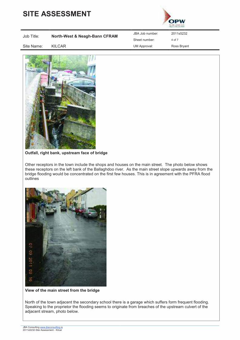
Other receptors in the town include the shops and houses on the main street. The photo below showsthese receptors on the left bank of the Ballaghdoo river. As the main street slope upwards away from thebridge flooding would be concentrated on the first few houses. This is in agreement with the PFRA floodoutlines
View of the main street from the bridge
North of the town adjacent the secondary school there is a garage which suffers form frequent flooding.Speaking to the proprietor the flooding seems to originate from breaches of the upstream culvert of theadjacent stream, photo below.
Receptors on the Glenaddragh river include the post office and some residential properties. The secondphoto below shows the road from the right bank sloping towards the main street. These additionalresidential units are potentially at risk of flooding and should be added to the list of receptors.
Post Office on the right bank downstream of the bridge
Additional residential properties at risk of flooding
OSi Licence No. EN 0021011
Recommended Extreme Flood Outline
Outside the town, south of the development boundary there is a WWTP which is at risk of coastal flooding.There are no formal defences protecting the WWTP.
Summary:The findings of the site visit confirms the extents of the PFRA flood outlines and in one case suggest thatthe outlines be extended to included two additional properties.
On the site visit two additional sources of flooding were identified that of the streams rising in the hill to thenorthwest of the town and the stream adjacent the garage to the north of the town.
The original FRI score for Kilcar is 184. The two additional properties are in the 1%AEP brings the FRIscore to 186. This is still under the AFA threshold of 250.
Based on these finding Kilcar should not be recommended an area for further investigation.
Name: Killybegs County: Donegal HA: 37 Unique ID: 375275Source of Flooding (Fluvial / Tidal) Fluvial/Tidal Type: AFAVisit By: Mairéad Conlon Date of Visit: 07/09/2011PFRA Data / Comments (taken from 110310_Final Database):The Initial PRFA study has found significant flood risk to designate Killybegs an AFA.Predictive assessment indicates potentially significant flood risk exists (FRI Total > 250). No strongevidence against inclusion as an AFA.
PFRA Database Comments (taken from 110309_ALL_VAL - Post Round Two - MA.mdb):OPW commentsNo comment in database
LA commentsRisk is likely to be Fish Meal Plant Culverts in town get blocked by debris, trees etc
Watercourses / Flood Sources:Killybegs, a coastal town is subject to tidal flooding of the Port, commercial and residential units. TheCashelcummin River, also a source of flooding, flows through the town. This river is tidally influenced and isreported to have flooded during periods of high tides and heavy rainfall.
Maps:See Flood Risk Review Site Map below.
Flood Outlines and Receptors:The fluvial risk originates from the Cashelcummin River which flows through the town. The Fire Station andHarbour are individually the highest scoring receptors (342 each) both are at risk from Tidal flooding. A fulllist of all receptors for Killybegs is shown in the table below.
This list was originally derived from the simplified coastal flood outlines which have since been replacedwith the ICPSS outlines. In the ICPSS outlines there are substantially less residential and commercialreceptors. The residential tidal score reduces to 20 and the commercial tidal score to 40. Therefore theoverall FRI score is reduced to 1037.The 1% AEP and the 10% AEP PFRA fluvial outlines are the same in extent. Therefore all fluvial receptorswere counted in the 10% AEP outline.
Comment on Flood Outlines:The outlines show that the town is vulnerable to fluvial and tidal flooding, with the threat from tidal flooding
being more dominant. There are two moderately vulnerable receptors in the coastal outline which need tobe accessed on site.
Defence Assets and Structures:There are coastal defences and a bridge structure in Killybegs. The coastal features include a rockrevetment and sea wall and these protect properties from coastal erosion and/or against tidal surges. Theupstream face of the culvert just before the river discharges into the sea which was blocked with debris atthe time of the site visit.
Environmental Impacts & Opportunities:There are no designated sites of nature conservation interest within, or located in close proximity, toKillybegs.There are approximately six monuments located within, or in close proximity to, this site, including a castleand a medieval house.
Floodmaps.ie Data:Information on high tides with properties affected.
ÿ D18. Killybegs - A combination of heavy rain and high tides causes flooding every year. The road isliable to flood and properties are affected. Flood Id = 4160
Other Relevant Information (e.g. web search, SFRA, other OPW studies and supplied data):None found
Discussions with Key Stakeholders:Speaking to a local the river floods during periods of heavy rainfall just downstream of the old fire station.This account confirms the record of flooding on flood maps.ie.
Key Contacts (local authority, local or community groups):Name Description Tel. Mobile Email AddressDeclan Gillespie Area Engineer n/a 087 9879130 n/a
During the site visit conversations with locals were held, and they provided information on flooding whichoccurs upstream of the Cashelcummin River during periods of heavy rainfall and high tides. This is detailedbelow under Site Visit Findings.
Site Visit Findings:Receptors with the greatest vulnerability in the town are the Fire station and the Port which are both in thetidal outline. These were confirmed as receptors on the site visit.
Photo of the fire station in relation to the coast
Photo of the Port
Receptors at potential risk from coastal flooding include commercial and residential units along the coastand in the main square.There are also some commercial and residential properties at risk of fluvial flooding. These units are in thecentre of the town adjacent the river.On the day of the site visit the upstream face of the culvert, just as the river discharges to the sea, was
During the site visit no evidence was found to suggest that any adjustment to the PFRA fluvial outline isrequired.
Summary:Killybegs is a coastal town vulnerable to tidal and fluvial flooding. Main receptors include the Fire Stationand the Port which on the site visit were both found to be at potential risk of tidal flooding.Based on the more detailed ICPSS coastal flood mapping and the site walkover the PFRA FRI score canbe reduced. With a revised score of 1037, the classification of Killybegs as an AFA remains and this siteshould go forward for further assessment.
Name: Killygordon County: Donegal HA: 01 Unique ID: 10645Source of Flooding (Fluvial / Tidal): Fluvial Type: AFAVisit By: Brian Phelan Date of Visit: 06/09/2011PFRA Data / Comments (taken from 110310_Final Database):Predictive assessment indicates potentially significant flood risk exists (FRI Total > 250). No strongevidence against inclusion as an AFA
PFRA Database Comments (taken from 110309_ALL_VAL - Post Round Two - MA.mdb):OPW commentsNo Comment
LA commentsAdjacent fields are located in the River Swilly flood plain.Housing Estate south of town would be liable to flood.
Watercourses / Sources of Flooding:Finn River (major watercourse that flows from west to east), Cross Roads Stream (enters the FinnWatercourse from the south of Killygordon), Killygordon Watercourse (flow through the town and entersthe River Finn on the right bank), Mullingar Water Course (North of Killygordon town)
Maps:See Flood Risk Review Site Map below.
Flood Outlines and Receptors:The total Flood Risk Index score for this town is 492.1. The majority of this figure is made up fromresidential properties (341) at flood risk. The remainder of the score is formed from commercial properties(110) and a monument (41).
Comment on Flood Outlines:The PFRA outlines and topography indicate the village is located on low lying land at the base of a valley.The outlines show out of bank fluvial flooding from the Finn River. Just south of Killygordon Bridge, thereare two properties indicated to be at risk on the PFRA 100yr outlines. There is a school bordering thePFRA outlines in this area also.South of this location there is a cluster of 10 properties at risk from the Mullingar Watercourse to the Northof the town.To the north of Killygordon there is also a cluster of approximately 20 properties at fluvial flood risk fromthe Cross Roads Stream.The outlines are broadly appropriate but have been amended in the Site Visit Findings section to pick upsome extra receptors found to be at risk.There is little difference between the PFRA flood outlines (10%, 1% and 0.1% AEP outlines) in terms ofreceptors at flood risk. The 0.1% AEP flood outline contains one more additional property than the 10%AEP flood outlines in Killygordon.
Defence Assets and Structures:ÿ There are earth embankments on the left bank of the River Finn, down stream of the Killygordon
Bridge;ÿ There is a major weir located approximately 300m upstream of Killygordon arched bridge;ÿ There is also a footbridge located at Killygordon bridge;ÿ There is an arched bridged located at the Cross Roads area where the Killygordon Watercourse
flows underneath, there is another located approximately 300m upstream of this point;ÿ There is an undersized culvert located at the point where the Mullingar watercourse flows under
the N16 road.
Environmental Impacts & Opportunities:This FRR site is located on the River Finn which is designated as a SAC. The features of interest withinthis SAC include riverine species (e.g. Otter and Salmon) and adjacent habitats including wet heaths,transition mires and quaking bogs, oligotrophic waters and blanket bog. Generally the habitats for whichthe River Finn SAC is designated are of low vulnerability to flooding, being waterlogged habitats tolerant ofperiodic inundation, however flooding which impacts on the nutrient status of the habitats could have anadverse impact. The species for which the River Finn SAC is designated may be adversely affected byflooding, particularly during their breeding seasons, through disturbance to spawning gravels or flooding ofholts. The site is also susceptible to water quality issues, and in-channel flood risk management workscould potentially have a significant impact.There are approximately five monuments located within close proximity to this FRR site, including standingstones and a cist.
Floodmaps.ie Data:From Floodmaps.ie Flood ID: Killygordon has 2 reports:
ReportType
Report Name File Type& Size
Date QualityCode
Description Source ofInformation
Report Flooding in Donegalby DCC
.pdf(93Kb)
26/Nov/2006 4 Report prepared by WaterServices Section of DonegalCounty Council for the OPWFlood Hazard Mapping Project. Itgives of known flooding areas(Report Includes: Source, Cause)
DonegalCountyCouncil
SourceMeetingMinutes
Stranorlar ElectoralEngineer - Minutes
.pdf(24Kb)
13/Jan/2006 4 Minutes of meeting identifyingareas subject to flooding -Donegal Stranorlar (ReportIncludes: Source, Cause)
DonegalCountyCouncil
Flooding in Donegal County Council by DCC (relevant section reproduced from floodmaps.ie)
Finn Valley Flood plain all along � frequent.Floods roads in places through streams back up
Stranorlar Electoral Engineer Meeting Minutes (relevant minutes reproduced from floodmaps.ie)ÿ S5. Killygordan - River Finn overflows its banks every year after heavy rain. Flood Id = 4180
Other Relevant Information (e.g. web search, SFRA, other OPW studies and supplied data):Damien McKay � Chartered Structural and Civil Engineer. Construction of a 110m multi span footbridge atKillygordon, Co. Donegal for Donegal County Council.Extract from his website about the issues faced when constructing the footbridge.�This river is prone to flash flooding with high river flows occurring within short periods of heavy rainfallgiven its contributing catchment�
Discussions with Key Stakeholders:A discussion was held with a number of lifelong residents of Killygordon. They commented;
ÿ No major issues with flooding in the town;ÿ The River Finn has overtopped the embankment downstream of Killygordon bridge;ÿ The river is tidal to Castlefinn but not Killygordon;ÿ The river bed is gravel in Killygordon, further downstream in Castlefinn the river bed contains
more silt/fines material.ÿ Flood waters have come very close to properties built on low ground opposite the School in the
past
Key Contacts (local authority, local or community groups):Name Description Tel. Mobile Email AddressMichaelMcFadden
Site Visit Findings:There are a number of receptors at risk from the Mullingar watercourse located at the North East of thetown. A local resident commented that flooding often occurs on the road shown in photo 1. It was notedthat the flooding was caused by an undersized culvert causing the watercourse to back up. The recentlybuilt dwellings on the left bank of the watercourse are confirmed as potentially at risk from this undersizedculvert and this is represented in the original PFRA outlines (see photo 2).
Photo 1 � The Mullingar Water Course (looking upstream � taken form the N16 road)
Photo 2 � Receptors on raised ground (Mullingar Water Course on left - N16 road on right)
Photo 3 � The Mullingar Water Course is on the left of dwelling. There is potential here for thewatercourse to overtop its banks and flood nearby dwellings.
The Waste Water Treatment Plant (WWTP) in Killygordon is not shown within the PFRA outlines. The sitevisit confirmed there is an earth embankment between the WWTP and the river. The level f risk isconsidered to be low due to the capacity of the channel and its high banks (discounting the earthembankment). However there is a potential residual risk and therefore this should be included for in theFRI scoring. With a potential flood risk in the 0.1% AEP this receptor will add 0.25 points to the FRI score.
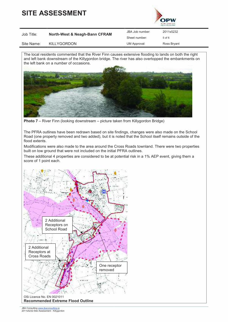
The local residents commented that the River Finn causes extensive flooding to lands on both the rightand left bank downstream of the Killygordon bridge. The river has also overtopped the embankments onthe left bank on a number of occasions.
Photo 7 � River Finn (looking downstream � picture taken from Killygordon Bridge)
The PFRA outlines have been redrawn based on site findings, changes were also made on the SchoolRoad (one property removed and two added), but it is noted that the School itself remains outside of theflood extents.Modifications were also made to the area around the Cross Roads townland. There were two propertiesbuilt on low ground that were not included on the initial PFRA outlines.These additional 4 properties are considered to be at potential risk in a 1% AEP event, giving them ascore of 1 point each.
OSi Licence No. EN 0021011Recommended Extreme Flood Outline
Summary:Killygordon was initially calculated as having an FRI score of 492.1, the site visit has indicated that thePFRA outlines are broadly consistent with the topography of the area, although some minor changes havebeen made to the PFRA fluvial outlines that have a small impact on the FRI score.Based on the net addition of 4 residential properties and the inclusion of the WWTP the FRI score willincrease by 4.25 up to 496.35. This is a minor change in score and does not affect the sites classificationas an AFA. Killygordon should go forward as an AFA in under the CFRAM study.
Name: Kilmacrenan County: Donegal HA: 39 Unique ID: 395406Source of Flooding (Fluvial / Tidal): Fluvial Type: AFAVisit By: Ed Blackburn Date of Visit: 08/09/2011PFRA Data / Comments (taken from 110310_Final Database):Predictive assessment indicates potentially significant flood risk exists (FRI Total > 250). No strongevidence against inclusion as an AFA.Approved � AFA.
PFRA Database Comments (taken from 110309_ALL_VAL - Post Round Two - MA.mdb):OPW commentsNo Comments
LA commentsOne Residential Estate would be vulnerable In times of heavy rainfall, existing culverts not capable of takingstorm flows. Minor flooding near Kilmacrennan Hall.
Watercourses / Sources of Flooding:Fluvial flooding from the Leannan and Lurgy Rivers. There are no historical records of pluvial flooding.
Map:See Flood Risk Review Site Map below.
Flood Outlines and ReceptorsKilmacrenan has a FRI score of 280.1; the scoring breakdown is given below. 8 residential properties arewithin the 10% AEP outline and a further 24 are within the 1% AEP outline. There are no critical receptors inthe PFRA outline.
Comment on Flood Outlines:An area of the PFRA outline for the Leannan River upstream of the confluence with the Lurgy River extendsbeyond an escarpment marked on the map. The validity of the outline in this area was investigated on siteas a large proportion of residential properties are in this locality. 8 of these properties are within the 10%AEP outline and a further 24 are within the 1% AEP outline. The PFRA outlines were adjusted accordinglyand are discussed in more detail under Site Visit Findings.
Historic mapping on OSI public viewer shows farmland upstream and downstream of Kilmacrenan markedas �liable to flood�.
Defence Assets and Structures:A natural escarpment on the left bank of the Leannan River acts as an informal effective flood defence forthe housing estate downstream of Milltown Bridge.
The two road bridges over the Leannan and Lurgy Rivers are not likely to be at risk of blockage.
Environmental Impacts & Opportunities:Kilmacrenan is located on the Leannan River SAC. This SAC is designated for its oligotrophic waters whichare vulnerable to nutrient enrichment which may arise from flood events. It is also a SAC for its wetlandspecies, including Freshwater Pearl Mussel, Salmon, Otter and Slender Naiad. These species may beadversely affected by flooding, particularly during their breeding seasons, through disturbance to spawninggravels or flooding of holts.There are approximately three monuments located within, or in close proximity to, this FRR site, includingBullaun stones and architectural fragments.
Floodmaps.ie Data:Minutes of a meeting with Milford Electoral Engineer in 2006 identified the following areas subject to flooding:
ÿ M24. Dromore - River Leannan overflows its banks every year after heavy rain. Approximately6 mile stretch of the river overflows its banks. The road is liable to flood and properties may beaffected. Flood Id = 4082*
ÿ M1. Kilmacrenan � River Leannan and Lurgy overflows their banks every year after heavy rain.A significant area is covered. Flood Id = 4059* (*Note � these areas are located upstream anddownstream of Kilmacrenan respectively and do not affect the town itself.)
Other Relevant Information (e.g. web search, SFRA, other OPW studies and supplied data):None found.
Discussions with Key Stakeholders:Donegal County Council has been contacted but is yet to respond to our information request.
Key Contacts (local authority, local or community groups):Name Description Tel. Mobile Email AddressTrevorGordon
Discussion with the Council Waste Water Treatment Plant Operator revealed that floodwaters have enteredthe grounds of the plant in the past but that local remedial works have been successful in preventing anyfurther flooding.
Site Visit Findings:All of the residential properties within the PFRA outline are located in a recently built housing estate on theleft bank of the Leannan River approximately 500 metres downstream of Milltown Bridge. 8 of these arewithin the 10% AEP outline and another 23 are within the 1% AEP. The site visit determined that themajority of these dwellings are not at risk of flooding as they are on higher ground which is protected by anatural escarpment on the left bank (see below and revised outline).
Looking upstream to house on higher ground. River and escarpment is to left.
The PFRA outline in this area is therefore not accurate as it does not represent the local topography.Removing 31 properties from the PFRA analysis that are deemed to be not at risk would significantly reducethe FRI score by 103 (8 houses within 10% AEP and 23 in between 10% and 1% AEP), resulting in areduced FRI score of 177.1 which is below the threshold for classification as an AFA.
The perimeter of the Waste Water Treatment Plant situated on the left bank of the Lurgy River downstreamof Kilmacrenan Bridge is within the 1% AEP PFRA outline. Including this receptor would add a maximum of2.5 to the overall FRI score. Discussion with the Council Site Operator revealed that floodwaters haveentered the grounds of the plant in the past but that local remedial works have been successful in preventingany further flooding. In the opinion of the Council Operative, flooding does not affect any properties inKilmacrenan. The only flooding of note has been to farmland both upstream and downstream of the town.
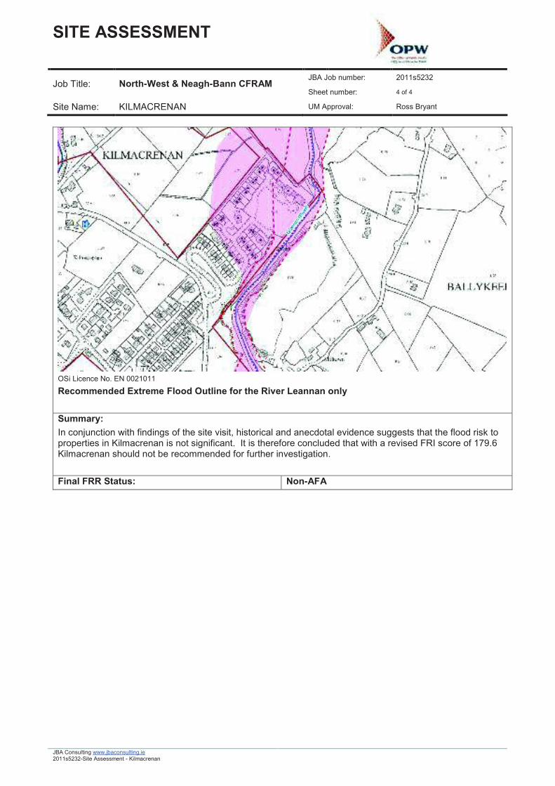
Recommended Extreme Flood Outline for the River Leannan only
Summary:In conjunction with findings of the site visit, historical and anecdotal evidence suggests that the flood risk toproperties in Kilmacrenan is not significant. It is therefore concluded that with a revised FRI score of 179.6Kilmacrenan should not be recommended for further investigation.
Name: Letterkenny County: Donegal HA: 39 Unique ID: 390607Source of Flooding (Fluvial / Tidal): Fluvial / Tidal Type: AFAVisit By: Rosalie Scanlon Date of Visit: 06/09/2011 to 08/09/2011PFRA Data / Comments (taken from 110310_Final Database):In the PFRA, Letterkenny was divided into Letterkenny and Letterkenny West. Letterkenny was broughtforward as an AFA as historic flood data and predicted flood extents supported its selection.Predictive assessment indicates potentially significant flood risk exists (FRI Total > 250). No strongevidence against inclusion as an AFA
PFRA Database Comments (taken from 110309_ALL_VAL - Post Round Two - MA.mdb):OPW commentsDonegal Schemes PFS
LA commentsCombination of Tidal Current from Lough Swilly, surface runoff from residential estates, Topography of townand large catchment. Large floodplain in town along River Swilly, zoned Town Centre extension, developedwith large retail warehouses, cinema,
Watercourses / Sources of Flooding:Fluvial flooding from the River Swilly and its tributaries, including the Coravaddy Burn and tidal floodingfrom Lough SwillyHydrometric Station: Gauging station managed by OPW, name Port Bridge, number 39061 with waterlevel records dating back to the 60s.
Maps:See Flood Risk Review Site Map below.
Flood Outlines and Receptors:The PFRA scoring breakdown for Letterkenny and Letterkenny West is given in the table below:
Letterkenny was given a FRI score of 6047.34. The majority of this score is for commercial and residentialproperties. Letterkenny West which is located within the Letterkenny urban boundary was assigned a scoreof 181.2. The majority of this score is for flood risk at The Elms housing estate located on the banks of anunnamed tributary of the Swilly River.Letterkenny West although not an AFA in its own right will be included in the assessment of the Letterkennyarea as it lies within the development boundary.
Comment on Flood Outlines:The PFRA flood extents were determined using a DTM. Limitations in DTM data means that the ground
model does not take into account the existence of flood defences along the Swilly River. This is consideredappropriate for the preliminary assessment as a residual risk remains behind such defences due to thepossibility of defence failure.The PFRA outlines are broadly acceptable and represent an undefended scenario. The PFRA outlinesshow out of bank flow in the vicinity of Letterkenny general hospital; the watercourse here is reported tooverflow its banks once every 3 years.
Defence Assets and Structures:Swilly Embankments � OPW maintained embankments extend along the River Swilly. The extent of theseis shown on the site map, using GIS data supplied by the OPW.Port Bridge � 5 corrugated steel pipes, coal yard on downstream left bank and flood embankment on allother banks; breach of defence here would cause flooding on Port RoadOldtown Bridge and Footbridge � road bridge consists of 3 stone arches and footbridge is a 3 span bridge ofsimilar proportionDisused Railway Bridge � consists of single span horizontal deck.These bridge structures on the Swilly River are not considered likely to have a significant impact on floodrisk.There are a number of culverts on the Sprackburn watercourse that are reported to be under capacity andcontribute to flooding in this area, namely the culvert at the Oatfield factory and the N15 culvert. (JBAReport, Tesco Letterkenny Flood Risk Assessment, August 2011)
Environmental Impacts & Opportunities:Letterkenny is located at the south-western point of Lough Swilly SAC and pNHA. This SAC is generallydesignated for its coastal habitats (e.g. estuaries, Spartina swards, salt meadows and coastal lagoons)which are generally of low vulnerability to flooding as inundation by tidal waters is natural process within thishabitat. The exception to this are the sessile oak woodland habitats for which the site is designated a SAC,which are intolerant of flooding. The site is also a SAC for its Otter population. Otter are generallyaccustomed to flooding, although inundation of a holt with cubs could have a significant impact.It is also located in relatively close proximity (upstream) to Lough Swilly SPA. This site is a SPA fornumerous wetland and wading bird species. The impact of flooding on these SPA species is in general low,although some wading species could be adversely impacted upon by inundation of intertidal feeding androosting areas which require populations to move elsewhere.There are approximately 15 monuments located within, or in close proximity to, this FRR site, including achurch, graveyard and standing stones.
Floodmaps.ie Data:There is a lot of evidence of historic flooding in Letterkenny. On floodmaps.ie there are press reports offlooding in 1985, 1986, 1989, 1990, and 2002.Areas that are known to flood include the hospital, UNIFY factory and Letterkenny IT.
Other Relevant Information (e.g. web search, SFRA, other OPW studies and supplied data):Donegal County Council commissioned 2 studies to provide planning and policy guidance for Letterkennyand Environs Development Plan. JB Barry together with Hydro Environmental completed the work whichincluded HEC-RAS model of River Swilly. One of the findings was that the embankments at Letterkenny,built originally under the Arterial Drainage Scheme, need to be raised and strengthened and flood storagewithin these embankments needs to be maintained.
Discussions with Key Stakeholders:A meeting was held with Area Engineers in Letterkenny Public Services Centre on Tuesday 13th September.Stephen Flynn is the area manager and he arranged a meeting with two of the Area Engineers, CharlieCannon and David Mc Ilwaine. The issues highlighted in Letterkenny urban area were:
ÿ There have been flooding problems at the Unify factory relating to a surface water culvertthere. The Unify factory is no longer operating. It is thought that there are plans to build aprivate medical facility here.
ÿ Flooding has occurred at Letterkenny General Hospital in the past. Flooding here hasaffected some hospital buildings including outhouses and stores.
ÿ There are issues with surface water flooding in a housing estate in the Magheranan area.ÿ The coal yard at the Port Bridge has been affected by flooding in the past.ÿ The Port Road and adjoining properties is a known flood prone area.ÿ The occurrence of flooding in the vicinity of the Institute of Technology was confirmed.
Business owners on the Port Road were approached and they confirmed the historical reports of flooding inthis area. Speaking to the landowner here one issue was related to surface water runoff not be able to draininto the River Swilly. This problem was alleviated when the council installed a large surface water culvert atthe back of the property. Flooding was reported in at the site of the Toyota garage about 10 � 12 years agowhen cars in the car park were partially submerged. The garage has since been rebuilt with raised finishedlevels.At the Top Oil depot, the owner reported that the last flooding seen by him was in 1964 and since then theembankments and drainage channels are maintained regularly by the OPW. The Cornavaddy Burn flowsalong this land to its confluence with the River Swilly. Upstream on the Burn there are a number ofproperties in the PFRA outline. From speaking with residents on the site visits they did not have anyaccount of fluvial flooding from the Burn. One businessman at Coyles� Ironworks has been in the area 35years and has not seen the Burn overflow. However there are issues in the area with pluvial flooding due tosurface water runoff from the road entering lower private properties. Work was done to rebuild a wall on theleft bank of the Burn after the original wall was undercut and fell in.
Key Contacts (local authority, local or community groups):Name Description Tel. Email AddressStephen Flynn Donegal County Council
Area Manager (RoadsSection) for LetterkennyElectoral Area
Site Visit Findings:As mentioned above, the watercourse that runs adjacent to Letterkenny hospital is reported to overflow itsbanks once every 3 years. From speaking to the local authority, it has been reported to affect buildings thatform part of the hospital. Letterkenny hospital was not included the PFRA scoring breakdown. Dependingon the probability of the hospital flooding (i.e. 10%, 1% or 0.1% AEP) this could increase the FRI by 25000to 250 points.The stream is culverted at the hospital grounds and was not located in this area on the site visit. Thestream passes through a number of culverts downstream of the hospital and these are reported to beundersized. This inadequacy has the potential to cause flooding due to backing up of water in the channel.The stream flows through the Oatfield factory site, under the regional R245 road, under the Letterkennyshopping centre, along by the western boundary of the IT and continues in an open embanked channelthrough 3 road culverts before it discharges into the River Swilly. There are reports of flooding at the haltingsite in the area of this confluence (floodmaps.ie).The land on the left bank of the river along Pearse Road is zoned commercial. The Letterkenny PublicService Centre building is located here. Embankment failure poses a significant flood risk for low lying landin this area. More recent development land in this area has been raised.
The N14 national primary route between Letterkenny and Derry has a history of flooding. There are anumber of commercial properties along this route at flood risk including a Toyota garage and LightingConcepts store.Further along the N14, at the Top Oil depot, the owner reported that the last flooding seen by him was in1964 and since then the embankments and drainage channels are maintained regularly by the OPW. TheCornavaddy Burn flows along this land to its confluence with the River Swilly.Upstream on this Burn there are a number of properties in the PFRA outline. The residents here confirmedthat there are flooding issues due to surface water road runoff and did not recall any fluvial flooding from theBurn. One businessman at Coyles� Ironworks has been in the area 35 years and has not seen the Burnoverflow.
Summary:There are a number of vulnerable receptors at flood risk in Letterkenny, including Letterkenny GeneralHospital. It is recommended that this FRR site be included as an AFA in the CFRAM study.The probability of failure of the flood embankments along the River Swilly is a factor that needs to beconsidered in assessing the flood risk.