78
R-WD-15-15 STATE OF NEW HAMPSHIRE 2012 305(b) Category 4A, 4B, and 4C Impairments Not Included in the 2014 305(b) Report March 27, 2017

R-WD-15-15
STATE OF NEW HAMPSHIRE
2012 305(b) Category 4A, 4B, and 4C Impairments Not
Included in the 2014 305(b) Report
March 27, 2017

2012 305(b) Category 4A, 4B, and 4C Impairments Not Included in the 2014 305(b) Report
2 of 78
R-WD-15-15
STATE OF NEW HAMPSHIRE
2012 305(b) Category 4A, 4B, and 4C Impairments Not
Included in the 2014 305(b) Report
STATE OF NEW HAMPSHIRE
DEPARTMENT OF ENVIRONMENTAL SERVICES
29 HAZEN DRIVE
CONCORD, N.H. 03301
CLARK B. FREISE
ASSISTANT COMMISSIONER
EUGENE FORBES, P.E.
DIRECTOR
WATER DIVISION
Prepared by:
Ken Edwardson
March 27, 2017
Printed on Recycled Paper
2012 305(b) Category 4A, 4B, and 4C Impairments Not Included in the 2014 305(b) Report
3 of 78
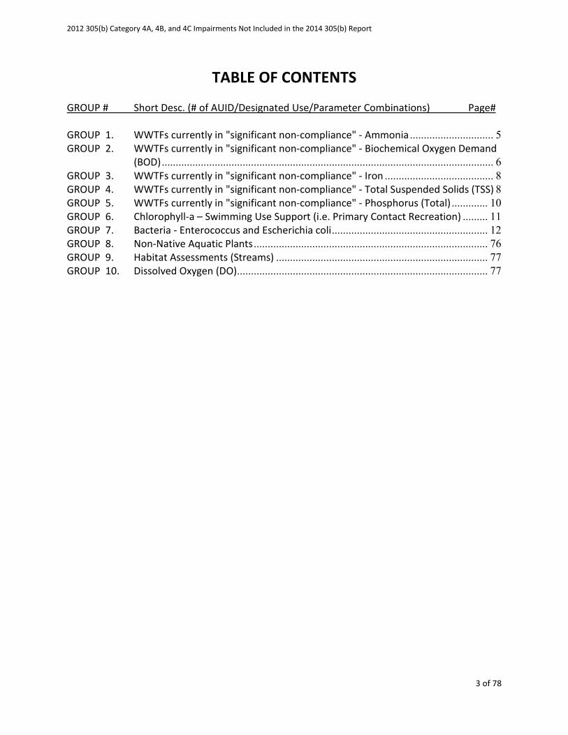
TABLE OF CONTENTS
GROUP # Short Desc. (# of AUID/Designated Use/Parameter Combinations) Page#
GROUP 1. WWTFs currently in "significant non-compliance" - Ammonia .............................. 5
GROUP 2. WWTFs currently in "significant non-compliance" - Biochemical Oxygen Demand
(BOD) ....................................................................................................................... 6
GROUP 3. WWTFs currently in "significant non-compliance" - Iron ....................................... 8
GROUP 4. WWTFs currently in "significant non-compliance" - Total Suspended Solids (TSS) 8
GROUP 5. WWTFs currently in "significant non-compliance" - Phosphorus (Total) ............. 10
GROUP 6. Chlorophyll-a – Swimming Use Support (i.e. Primary Contact Recreation) ......... 11
GROUP 7. Bacteria - Enterococcus and Escherichia coli ........................................................ 12
GROUP 8. Non-Native Aquatic Plants .................................................................................... 76
GROUP 9. Habitat Assessments (Streams) ............................................................................ 77
GROUP 10. Dissolved Oxygen (DO) .......................................................................................... 77

2012 305(b) Category 4A, 4B, and 4C Impairments Not Included in the 2014 305(b) Report
4 of 78
Introduction
In accordance with Section 303(d) of the federal Clean Water Act, States must prepare a list of
impaired waters that require a Total Maximum Daily Load study every 2 years (i.e., the 303(d)
List). In parallel each State produces a 305(b) report which includes impaired waters that do not
require a TMDL because either; a TMDL has been completed (aka category 4A waters), other
enforceable pollution control measure are expected to restore water quality (aka category 4B
waters, or the impairment is due to a non-pollutant such as exotic weeds (aka category 4C
waters). This document provides a list of all surface waters that were removed from the 4A, 4B,
and 4C impairment categories (i.e., “deimpaired”) and the reasons why they were removed.
Assessment outcomes cover a spectrum from very good to very bad coded as an alpha numeric
scale that provides additional distinctions in cases where and impairment exists. In each of the
deimpairments detailed within this document the 2012 and 2014 assessment status is
highlighted applying the categories in the table below.
Severe Poor Likely
Bad
No
Data
Likely
Good
Marginal Good
Not
Supporting,
Severe
Not
Supporting,
Marginal
Insufficient
Information –
Potentially Not
Supporting
No Data
Insufficient
Information –
Potentially Full
Supporting
Full Support,
Marginal
Full Support,
Good
CATEGORY Description
*Category 2 Meets standards 2-M or
2-OBS 2-G
Category 3 Insufficient
Information 3-PNS 3-ND 3-PAS
Category 4
Does not Meet
Standards;
4A TMDL Completed 4A-P 4A-M or
4A-T
4B
Other enforceable
measure will
correct the issue.
4B-P 4B-M or
4B-T
4C Non-pollutant (i.e.
exotic weeds) 4C-P 4C-M
Category 5 TMDL Needed 5-P 5-M or
5-T
2012 305(b) Category 4A, 4B, and 4C Impairments Not Included in the 2014 305(b) Report
5 of 78
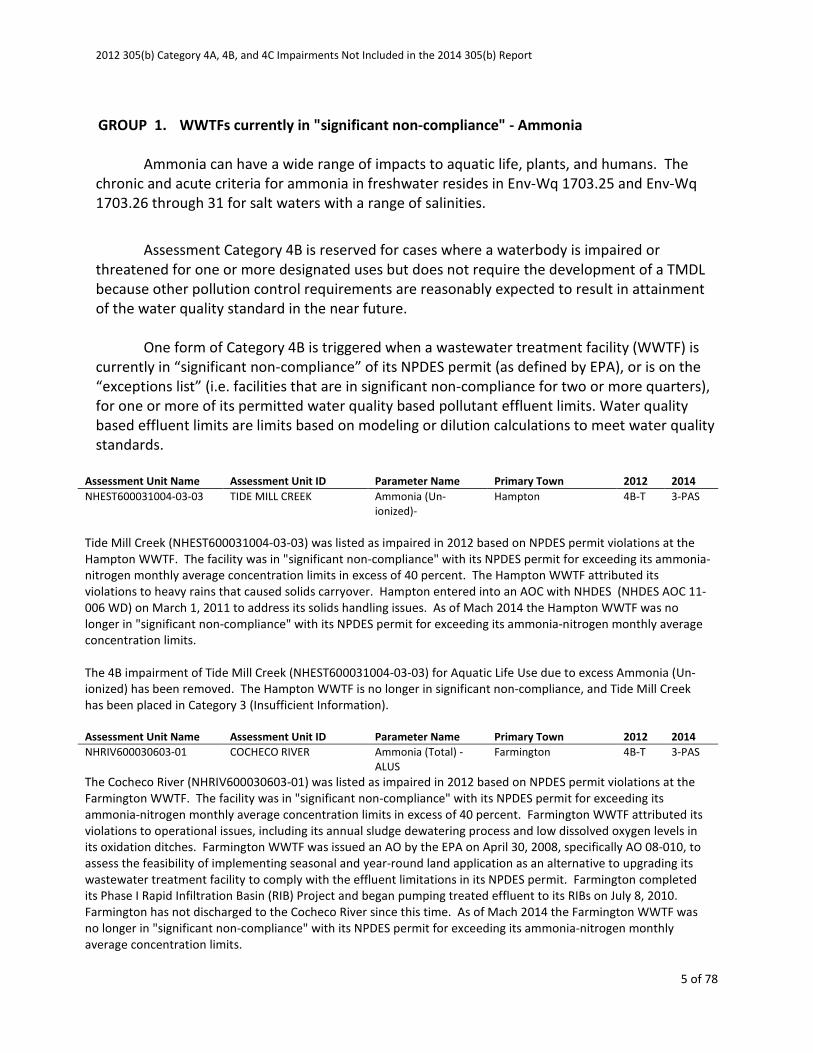
GROUP 1. WWTFs currently in "significant non-compliance" - Ammonia
Ammonia can have a wide range of impacts to aquatic life, plants, and humans. The
chronic and acute criteria for ammonia in freshwater resides in Env-Wq 1703.25 and Env-Wq
1703.26 through 31 for salt waters with a range of salinities.
Assessment Category 4B is reserved for cases where a waterbody is impaired or
threatened for one or more designated uses but does not require the development of a TMDL
because other pollution control requirements are reasonably expected to result in attainment
of the water quality standard in the near future.
One form of Category 4B is triggered when a wastewater treatment facility (WWTF) is
currently in “significant non-compliance” of its NPDES permit (as defined by EPA), or is on the
“exceptions list” (i.e. facilities that are in significant non-compliance for two or more quarters),
for one or more of its permitted water quality based pollutant effluent limits. Water quality
based effluent limits are limits based on modeling or dilution calculations to meet water quality
standards.
Assessment Unit Name Assessment Unit ID Parameter Name Primary Town 2012 2014
NHEST600031004-03-03 TIDE MILL CREEK Ammonia (Un-
ionized)-
Hampton 4B-T 3-PAS
Tide Mill Creek (NHEST600031004-03-03) was listed as impaired in 2012 based on NPDES permit violations at the
Hampton WWTF. The facility was in "significant non-compliance" with its NPDES permit for exceeding its ammonia-
nitrogen monthly average concentration limits in excess of 40 percent. The Hampton WWTF attributed its
violations to heavy rains that caused solids carryover. Hampton entered into an AOC with NHDES (NHDES AOC 11-
006 WD) on March 1, 2011 to address its solids handling issues. As of Mach 2014 the Hampton WWTF was no
longer in "significant non-compliance" with its NPDES permit for exceeding its ammonia-nitrogen monthly average
concentration limits.
The 4B impairment of Tide Mill Creek (NHEST600031004-03-03) for Aquatic Life Use due to excess Ammonia (Un-
ionized) has been removed. The Hampton WWTF is no longer in significant non-compliance, and Tide Mill Creek
has been placed in Category 3 (Insufficient Information).
Assessment Unit Name Assessment Unit ID Parameter Name Primary Town 2012 2014
NHRIV600030603-01 COCHECO RIVER Ammonia (Total) -
ALUS
Farmington 4B-T 3-PAS
The Cocheco River (NHRIV600030603-01) was listed as impaired in 2012 based on NPDES permit violations at the
Farmington WWTF. The facility was in "significant non-compliance" with its NPDES permit for exceeding its
ammonia-nitrogen monthly average concentration limits in excess of 40 percent. Farmington WWTF attributed its
violations to operational issues, including its annual sludge dewatering process and low dissolved oxygen levels in
its oxidation ditches. Farmington WWTF was issued an AO by the EPA on April 30, 2008, specifically AO 08-010, to
assess the feasibility of implementing seasonal and year-round land application as an alternative to upgrading its
wastewater treatment facility to comply with the effluent limitations in its NPDES permit. Farmington completed
its Phase I Rapid Infiltration Basin (RIB) Project and began pumping treated effluent to its RIBs on July 8, 2010.
Farmington has not discharged to the Cocheco River since this time. As of Mach 2014 the Farmington WWTF was
no longer in "significant non-compliance" with its NPDES permit for exceeding its ammonia-nitrogen monthly
average concentration limits.
2012 305(b) Category 4A, 4B, and 4C Impairments Not Included in the 2014 305(b) Report
6 of 78
The 4B impairment of the Cocheco River (NHRIV600030603-01) for Aquatic Life Use due to excess Ammonia (Total)
has been removed. The Farmington WWTF is no longer in significant non-compliance, and the Cocheco River has
been placed in Category 3 (Insufficient Information).
GROUP 2. WWTFs currently in "significant non-compliance" - Biochemical Oxygen Demand
(BOD)
Dissolved oxygen is critical to the balanced, integrative, and adaptive community of
organisms as described in Env-Wq 1703.19. As such, the water quality standard provide criteria
for Class A waters, Class B waters, waters with cold water fish species, and in both thermally
stratified and unstratified lakes, impoundments, and reservoirs in Env-Wq 1703.07 (a), (b), (c),
and (d). Wastewater treatment facility (WWTF) discharge permits from EPA include a
biochemical oxygen demand (BOD) such that during the periods of highest stress on the aquatic
organism, when the temperature is high and the natural reaeration is low, the WWTF does not
drive the dissolved oxygen in the system to unhealthy low levels.
Assessment Category 4B is reserved for cases where a waterbody is impaired or
threatened for one or more designated uses but does not require the development of a TMDL
because other pollution control requirements are reasonably expected to result in attainment
of the water quality standard in the near future.
One form of Category 4B is triggered when a wastewater treatment facility (WWTF) is
currently in “significant non-compliance” of its NPDES permit (as defined by EPA), or is on the
“exceptions list” (i.e. facilities that are in significant non-compliance for two or more quarters),
for one or more of its permitted water quality based pollutant effluent limits. Water quality
based effluent limits are limits based on modeling or dilution calculations to meet water quality
standards.
Assessment Unit Name Assessment Unit ID Parameter Name Primary Town 2012 2014
NHRIV700030104-18 CONTOOCOOK RIVER - US
OF PETERBOROUGH
WWTF TO BOGLIE BK
BOD, Biochemical
oxygen demand
Peterborough 4B-T 3-PAS
The Contoocook River, starting several hundred feet upstream of the Peterborough WWTF and continuing to Boglie
Brook (NHRIV700030104-18) was listed as impaired in 2012 based on NPDES permit violations at the Peterborough
WWTF. The Peterborough WWTF was in violation of its NPDES permit from January thru May of 2009 and from
January thru March of 2010, for effluent BOD monthly average concentration limit violations; and from January
thru April of 2010 for effluent BOD monthly average loading limit violations. The facility was in "significant non-
compliance" with its NPDES permit for exceeding its effluent BOD monthly average concentration and load limits in
excess of 40 percent. The BOD violations in 2009 were attributed to low lagoon levels combined with colder
temperatures decreasing biological activity. The BOD violations in 2010 were attributed to decreased biological
activity due to colder temperatures, and nitrification occurring. As of Mach 2014 the Peterborough WWTF was no
longer in "significant non-compliance" with its NPDES permit for exceeding its BOD monthly average concentration
and load limits.
2012 305(b) Category 4A, 4B, and 4C Impairments Not Included in the 2014 305(b) Report
7 of 78
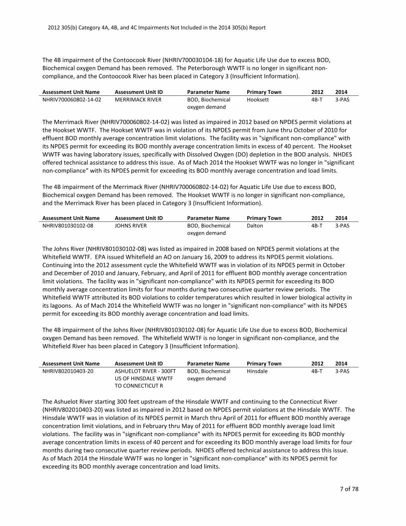
The 4B impairment of the Contoocook River (NHRIV700030104-18) for Aquatic Life Use due to excess BOD,
Biochemical oxygen Demand has been removed. The Peterborough WWTF is no longer in significant non-
compliance, and the Contoocook River has been placed in Category 3 (Insufficient Information).
Assessment Unit Name Assessment Unit ID Parameter Name Primary Town 2012 2014
NHRIV700060802-14-02 MERRIMACK RIVER BOD, Biochemical
oxygen demand
Hooksett 4B-T 3-PAS
The Merrimack River (NHRIV700060802-14-02) was listed as impaired in 2012 based on NPDES permit violations at
the Hookset WWTF. The Hookset WWTF was in violation of its NPDES permit from June thru October of 2010 for
effluent BOD monthly average concentration limit violations. The facility was in "significant non-compliance" with
its NPDES permit for exceeding its BOD monthly average concentration limits in excess of 40 percent. The Hookset
WWTF was having laboratory issues, specifically with Dissolved Oxygen (DO) depletion in the BOD analysis. NHDES
offered technical assistance to address this issue. As of Mach 2014 the Hookset WWTF was no longer in "significant
non-compliance" with its NPDES permit for exceeding its BOD monthly average concentration and load limits.
The 4B impairment of the Merrimack River (NHRIV700060802-14-02) for Aquatic Life Use due to excess BOD,
Biochemical oxygen Demand has been removed. The Hookset WWTF is no longer in significant non-compliance,
and the Merrimack River has been placed in Category 3 (Insufficient Information).
Assessment Unit Name Assessment Unit ID Parameter Name Primary Town 2012 2014
NHRIV801030102-08 JOHNS RIVER BOD, Biochemical
oxygen demand
Dalton 4B-T 3-PAS
The Johns River (NHRIV801030102-08) was listed as impaired in 2008 based on NPDES permit violations at the
Whitefield WWTF. EPA issued Whitefield an AO on January 16, 2009 to address its NPDES permit violations.
Continuing into the 2012 assessment cycle the Whitefield WWTF was in violation of its NPDES permit in October
and December of 2010 and January, February, and April of 2011 for effluent BOD monthly average concentration
limit violations. The facility was in "significant non-compliance" with its NPDES permit for exceeding its BOD
monthly average concentration limits for four months during two consecutive quarter review periods. The
Whitefield WWTF attributed its BOD violations to colder temperatures which resulted in lower biological activity in
its lagoons. As of Mach 2014 the Whitefield WWTF was no longer in "significant non-compliance" with its NPDES
permit for exceeding its BOD monthly average concentration and load limits.
The 4B impairment of the Johns River (NHRIV801030102-08) for Aquatic Life Use due to excess BOD, Biochemical
oxygen Demand has been removed. The Whitefield WWTF is no longer in significant non-compliance, and the
Whitefield River has been placed in Category 3 (Insufficient Information).
Assessment Unit Name Assessment Unit ID Parameter Name Primary Town 2012 2014
NHRIV802010403-20 ASHUELOT RIVER - 300FT
US OF HINSDALE WWTF
TO CONNECTICUT R
BOD, Biochemical
oxygen demand
Hinsdale 4B-T 3-PAS
The Ashuelot River starting 300 feet upstream of the Hinsdale WWTF and continuing to the Connecticut River
(NHRIV802010403-20) was listed as impaired in 2012 based on NPDES permit violations at the Hinsdale WWTF. The
Hinsdale WWTF was in violation of its NPDES permit in March thru April of 2011 for effluent BOD monthly average
concentration limit violations, and in February thru May of 2011 for effluent BOD monthly average load limit
violations. The facility was in "significant non-compliance" with its NPDES permit for exceeding its BOD monthly
average concentration limits in excess of 40 percent and for exceeding its BOD monthly average load limits for four
months during two consecutive quarter review periods. NHDES offered technical assistance to address this issue.
As of Mach 2014 the Hinsdale WWTF was no longer in "significant non-compliance" with its NPDES permit for
exceeding its BOD monthly average concentration and load limits.
2012 305(b) Category 4A, 4B, and 4C Impairments Not Included in the 2014 305(b) Report
8 of 78
The 4B impairment of the Ashuelot River (NHRIV802010403-20) for Aquatic Life Use due to excess BOD,
Biochemical oxygen Demand has been removed. The Hinsdale WWTF is no longer in significant non-compliance,
and the Ashuelot River has been placed in Category 3 (Insufficient Information).
GROUP 3. WWTFs currently in "significant non-compliance" - Iron
When Iron rich waters mix with healthy oxygen rich waters, ferric hydroxide (Fe(OH)3)
floc can form on coat the gills of some fish impairing their ability to breath. Precipitates of iron
can then settle smothering benthic invertebrates, plants, and fish eggs. In severe cases,
precipitates may consolidate thereby creating impenetrable hard bottoms.
Assessment Category 4B is reserved for cases where a waterbody is impaired or
threatened for one or more designated uses but does not require the development of a TMDL
because other pollution control requirements are reasonably expected to result in attainment
of the water quality standard in the near future.
One form of Category 4B is triggered when a wastewater treatment facility (WWTF) is
currently in “significant non-compliance” of its NPDES permit (as defined by EPA), or is on the
“exceptions list” (i.e. facilities that are in significant non-compliance for two or more quarters),
for one or more of its permitted water quality based pollutant effluent limits. Water quality
based effluent limits are limits based on modeling or dilution calculations to meet water quality
standards.
Assessment Unit Name Assessment Unit ID Parameter Name Primary Town 2012 2014
NHRIV801030403-07 AMMONOOSUC RIVER Iron-ALUS Bethlehem 4B-T 3-PAS
Ammonoosuc River (NHRIV801030403-07) was listed as impaired in 2012 based on NPDES permit violations in April,
July and October 2010 for effluent iron daily maximum concentration limit violations at the GDF Suez Energy
Generation (Bethlehem Power Plant). The facility was in "significant non-compliance" with its NPDES permit for
exceeding its iron daily maximum concentration limits in excess of 40 percent. Suez Energy attributed its iron
violations to groundwater infiltration in its stormwater system having naturally occurring high levels of iron. Suez
Energy removed its stormwater from its collection system, and has since maintained compliance with its iron limits.
As of Mach 2014 Suez Energy was no longer in "significant non-compliance" with its NPDES permit for exceeding its
iron daily maximum concentration limits.
The 4B impairment of the Ammonoosuc River (NHRIV801030403-07) for Aquatic Life Use due to excess Iron has
been removed. The GDF Suez Energy Generation (Bethlehem Power Plant) is no longer in significant non-
compliance, and the Ammonoosuc River has been placed in Category 3 (Insufficient Information).
GROUP 4. WWTFs currently in "significant non-compliance" - Total Suspended Solids (TSS)
The concentration of total dissolved solids are made up of calcium, chlorides, nitrate,
phosphorus, iron, sulfur, and other ions particles and affect the water balance in the cells of

2012 305(b) Category 4A, 4B, and 4C Impairments Not Included in the 2014 305(b) Report
9 of 78
aquatic organisms. Total solids also affect water clarity. Higher solids decrease the passage of
light through water, thereby slowing photosynthesis by aquatic plants. Water will heat up more
rapidly and hold more heat; this, in turn, might adversely affect aquatic life that has adapted to
a lower temperature regime and/or reduce the amount of oxygen available in the water for
aquatic organisms.
Assessment Category 4B is reserved for cases where a waterbody is impaired or
threatened for one or more designated uses but does not require the development of a TMDL
because other pollution control requirements are reasonably expected to result in attainment
of the water quality standard in the near future.
One form of Category 4B is triggered when a wastewater treatment facility (WWTF) is
currently in “significant non-compliance” of its NPDES permit (as defined by EPA), or is on the
“exceptions list” (i.e. facilities that are in significant non-compliance for two or more quarters),
for one or more of its permitted water quality based pollutant effluent limits. Water quality
based effluent limits are limits based on modeling or dilution calculations to meet water quality
standards.
Assessment Unit Name Assessment Unit ID Parameter Name Primary Town 2012 2014
NHEST600031003-02 TAYLOR RIVER Total Suspended
Solids (TSS)
Hampton 4B-T 3-PAS
The Taylor River (NHEST600031003-02) was listed as impaired in 2012 based on NPDES permit violations in
February and May thru July of 2011 for effluent TSS daily maximum concentration limit violations at Aquatic
Research Organisms. The facility was in "significant non-compliance" with its NPDES permit for exceeding its TSS
daily maximum concentration limits in excess of 40 percent. Aquatic Research Organisms was unable to attribute
its violations to a specific cause. As of Mach 2014 Aquatic Research Organisms was no longer in "significant non-
compliance" with its NPDES permit for exceeding its TSS daily maximum concentration limits.
The 4B impairment of the Taylor River (NHEST600031003-02) for Aquatic Life Use due to excess TSS has been
removed. Aquatic Research Organisms is no longer in significant non-compliance, and the Taylor River has been
placed in Category 3 (Insufficient Information).
Assessment Unit Name Assessment Unit ID Parameter Name Primary Town 2012 2014
NHRIV801030403-03 AMMONOOSUC RIVER Total Suspended
Solids (TSS)
Bethlehem 4B-T 3-PAS
The Ammonoosuc River (NHRIV801030403-03) was listed as impaired in 2012 based on NPDES permit violations in
April and July thru September 2010 for effluent TSS monthly average concentration limit violations at Bethlehem
Village District. The facility was in "significant non-compliance" with its NPDES permit for exceeding its effluent TSS
monthly average concentration limits for four months during two consecutive quarter review periods. Bethlehem
Village District attributed its violations to algae blooms within its lagoons. As of Mach 2014 Bethlehem Village
District was no longer in "significant non-compliance" with its NPDES permit for exceeding its TSS monthly average
concentration limits.
The 4B impairment of the Ammonoosuc River (NHRIV801030403-03) for Aquatic Life Use due to excess TSS has
been removed. Bethlehem Village District is no longer in significant non-compliance, and the Ammonoosuc River
has been placed in Category 3 (Insufficient Information).
2012 305(b) Category 4A, 4B, and 4C Impairments Not Included in the 2014 305(b) Report
10 of 78
GROUP 5. WWTFs currently in "significant non-compliance" - Phosphorus (Total)
While essential to plants and animals, phosphorus is the limiting nutrient in freshwater
systems. The stress induced by too much phosphorus can lead to a series of detrimental
responses from excess plant growth, to algae blooms, to decreased dissolved oxygen, and the
loss of benthic macroinvertebrates and fish species.
Assessment Category 4B is reserved for cases where a waterbody is impaired or
threatened for one or more designated uses but does not require the development of a TMDL
because other pollution control requirements are reasonably expected to result in attainment
of the water quality standard in the near future.
One form of Category 4B is triggered when a wastewater treatment facility (WWTF) is
currently in “significant non-compliance” of its NPDES permit (as defined by EPA), or is on the
“exceptions list” (i.e. facilities that are in significant non-compliance for two or more quarters),
for one or more of its permitted water quality based pollutant effluent limits. Water quality
based effluent limits are limits based on modeling or dilution calculations to meet water quality
standards.
Assessment Unit Name Assessment Unit ID Parameter Name Primary Town 2012 2014
NHIMP600030406-03 SALMON FALLS RIVER -
ROLLINSFORD DAM
Phosphorus (Total) Rollinsford 4B-T 3-PAS
The Salmon Falls River - Rollinsford Dam (NHIMP600030406-03) was listed as impaired in 2012 based on NPDES
permit violations in July thru September 2010 for effluent phosphorous monthly average concentration limit
violations at the Somersworth WPCF. The facility was in "significant non-compliance" with its NPDES permit for
exceeding its phosphorous monthly average concentration limits in excess of 40 percent. Somersworth WPCF
attributed its violations to a combination of very low flows, higher than average influent BOD loadings, and
restricted internal flow rates. NHDES offered technical assistance to address Somersworth's issues. As of Mach
2014 Somersworth WPCF was no longer in "significant non-compliance" with its NPDES permit for exceeding its
phosphorous monthly average concentration limits.
The 4B impairment of the Salmon Falls River - Rollinsford Dam (NHIMP600030406-03) for Aquatic Life Use due to
excess total phosphorus has been removed. Somersworth WPCF is no longer in significant non-compliance, and the
Salmon Falls River - Rollinsford Dam has been placed in Category 3 (Insufficient Information).
Assessment Unit Name Assessment Unit ID Parameter Name Primary Town 2012 2014
NHRIV700030104-18 CONTOOCOOK RIVER - US
OF PETERBOROUGH
WWTF TO BOGLIE BK
Phosphorus (Total) Peterborough 4B-T 3-PAS
The Contoocook River - Upstream of Peterborough WWTF to Boglie Bk (NHRIV700030104-18) was listed as
impaired in 2008 based on NPDES permit violations from July thru December 2007 for effluent phosphorous
monthly average concentration limit violations at the Peterborough WWTF. The facility was in "significant non-
compliance" with its NPDES permit for exceeding its phosphorous monthly average concentration limits in excess of
40 percent. Effective May 1, 2007, Peterborough WWTF was issued a new NPDES permit establishing a more
stringent discharge limit for effluent phosphorous concentration. The Peterborough WWTF was in violation of its
NPDES permit from October 2008 thru March 2009 for effluent phosphorous monthly average concentration limit
violations. The facility was in "significant non-compliance" with its NPDES permit for exceeding its effluent
phosphorous monthly average concentration limits in excess of 40 percent. Peterborough WWTF was issued an
2012 305(b) Category 4A, 4B, and 4C Impairments Not Included in the 2014 305(b) Report
11 of 78
Administrative Order by Consent (AOC) by the NHDES on March 10, 2009 (AO 09-002 WD effective date March 19,
2009). The AO established interim effluent limits for total phosphorous, including 6.0 mg/L for average monthly
limit. Peterborough violated its interim limit for total phosphorous in February 2010 and in January and February
2011. As of Mach 2014 the Peterborough WWTF was no longer in "significant non-compliance" with its NPDES
permit for exceeding its phosphorous monthly average concentration limits.
The 4B impairment of the Contoocook River - UU Of Peterborough WWTF to Boglie Bk (NHRIV700030104-18) for
Aquatic Life Use due to excess total phosphorus has been removed. The Peterborough WWTF is no longer in
significant non-compliance, and the Contoocook River - US of Peterborough WWTF to Boglie Bk has been placed in
Category 3 (Insufficient Information).
GROUP 6. Chlorophyll-a – Swimming Use Support (i.e. Primary Contact Recreation)
Excessive algal growth (high biomass and high chlorophyll-a values) can impair the
public safety and aesthetic enjoyment of surface waters. The General Water Quality Criteria
(Env-Wq 1703.03) require that surface waters be free of substances which: produce color or
turbidity making the water unsuitable for the designated use, or interfere with recreational
activities (Env-Wq 1703.03 (c)(1) c & e). For assessment purposes, chlorophyll-a concentrations
in excess of 15 µg/L in fresh water and 20 µg/L in salt water are indicators of excessive algal
growth that interferes with recreational activities.
Assessment category 4A is reserved for cases where a waterbody is impaired or
threatened for one or more designated uses but does not require the development of a TMDL
because a TMDL has been completed
Assessment Unit Name Assessment Unit ID Parameter Name Primary Town 2012 2014
NHLAK700040402-01 FLINTS POND Chlorophyll-a - PCR Hollis 4A-M 2-M
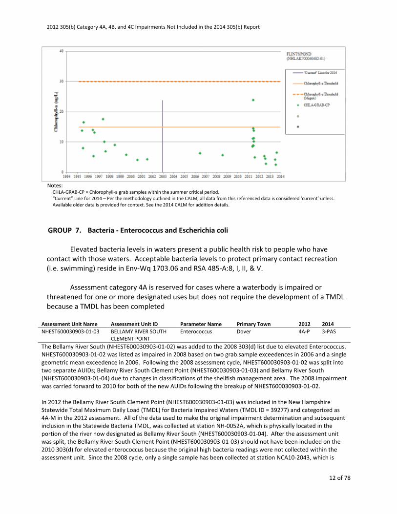
Flints Pond (NHLAK700040402-01) was listed as impaired in 2006 due to elevated chlorophyll-a, particularly two
elevated readings of 17.5 µg/L and 16.4 µg/L on 6/3/1997 and 8/20/1995, respectively. During the current
assessment period (2003 to 2014), there has been only one sample that exceeded the 15 µg/L threshold. A single
sample from 1998 to 2013 collected on 6/22/2011 was 23.7 µg/L. All of the samples collected in 2012 and 2013
were less than 7 µg/L and were collected under similar conditions as the past exceedences. The frequency of
apparent high values does not warrant waterbody impairment.
The 4A impairment of Flints Pond (NHLAK700040402-01) for Primary Contact Recreation (i.e. swimming) due to
elevated chlorophyll-a has been removed. Flints Pond has been placed in Category 2 (Full Support).
2012 305(b) Category 4A, 4B, and 4C Impairments Not Included in the 2014 305(b) Report
12 of 78
Notes:
CHLA-GRAB-CP = Chlorophyll-a grab samples within the summer critical period.
“Current” Line for 2014 – Per the methodology outlined in the CALM, all data from this referenced data is considered ‘current’ unless.
Available older data is provided for context. See the 2014 CALM for addition details.
GROUP 7. Bacteria - Enterococcus and Escherichia coli
Elevated bacteria levels in waters present a public health risk to people who have
contact with those waters. Acceptable bacteria levels to protect primary contact recreation
(i.e. swimming) reside in Env-Wq 1703.06 and RSA 485-A:8, I, II, & V.
Assessment category 4A is reserved for cases where a waterbody is impaired or
threatened for one or more designated uses but does not require the development of a TMDL
because a TMDL has been completed
Assessment Unit Name Assessment Unit ID Parameter Name Primary Town 2012 2014
NHEST600030903-01-03 BELLAMY RIVER SOUTH
CLEMENT POINT
Enterococcus Dover 4A-P 3-PAS
The Bellamy River South (NHEST600030903-01-02) was added to the 2008 303(d) list due to elevated Enterococcus.
NHEST600030903-01-02 was listed as impaired in 2008 based on two grab sample exceedences in 2006 and a single
geometric mean exceedence in 2006. Following the 2008 assessment cycle, NHEST600030903-01-02 was split into
two separate AUIDs; Bellamy River South Clement Point (NHEST600030903-01-03) and Bellamy River South
(NHEST600030903-01-04) due to changes in classifications of the shellfish management area. The 2008 impairment
was carried forward to 2010 for both of the new AUIDs following the breakup of NHEST600030903-01-02.
In 2012 the Bellamy River South Clement Point (NHEST600030903-01-03) was included in the New Hampshire
Statewide Total Maximum Daily Load (TMDL) for Bacteria Impaired Waters (TMDL ID = 39277) and categorized as
4A-M in the 2012 assessment. All of the data used to make the original impairment determination and subsequent
inclusion in the Statewide Bacteria TMDL, was collected at station NH-0052A, which is physically located in the
portion of the river now designated as Bellamy River South (NHEST600030903-01-04). After the assessment unit
was split, the Bellamy River South Clement Point (NHEST600030903-01-03) should not have been included on the
2010 303(d) for elevated enterococcus because the original high bacteria readings were not collected within the
assessment unit. Since the 2008 cycle, only a single sample has been collected at station NCA10-2043, which is
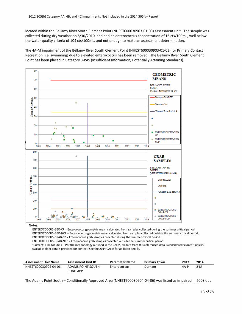
2012 305(b) Category 4A, 4B, and 4C Impairments Not Included in the 2014 305(b) Report
13 of 78
located within the Bellamy River South Clement Point (NHEST600030903-01-03) assessment unit. The sample was
collected during dry weather on 8/30/2010, and had an enterococcus concentration of 16 cts/100mL, well below
the water quality criteria of 104 cts/100mL, and not enough to make an assessment determination.
The 4A-M impairment of the Bellamy River South Clement Point (NHEST600030903-01-03) for Primary Contact
Recreation (i.e. swimming) due to elevated enterococcus has been removed. The Bellamy River South Clement
Point has been placed in Category 3-PAS (Insufficient Information, Potentially Attaining Standards).
Notes:
ENTEROCOCCUS-GEO-CP = Enterococcus geometric mean calculated from samples collected during the summer critical period.
ENTEROCOCCUS-GEO-NCP = Enterococcus geometric mean calculated from samples collected outside the summer critical period.
ENTEROCOCCUS-GRAB-CP = Enterococcus grab samples collected during the summer critical period.
ENTEROCOCCUS-GRAB-NCP = Enterococcus grab samples collected outside the summer critical period.
“Current” Line for 2014 – Per the methodology outlined in the CALM, all data from this referenced data is considered ‘current’ unless.
Available older data is provided for context. See the 2014 CALM for addition details.
Assessment Unit Name Assessment Unit ID Parameter Name Primary Town 2012 2014
NHEST600030904-04-06 ADAMS POINT SOUTH -
COND APP
Enterococcus Durham 4A-P 2-M
The Adams Point South – Conditionally Approved Area (NHEST600030904-04-06) was listed as impaired in 2008 due

2012 305(b) Category 4A, 4B, and 4C Impairments Not Included in the 2014 305(b) Report
14 of 78
to elevated Enterococcus for both primary and secondary contact recreation. This assessment unit was listed as
impaired based on grab sample exceedences in 2006 and 2010. There have been no geometric mean exceedences
recorded from 2002 to 2013. During that same time period 1.5% and 0.8% of the samples exceeded the grab
sample criteria for enterococcus for primary contact recreation and secondary contact recreation, respectively.
Since 2010 the site has been sampled every year without a single grab sample exceedence or geometric mean
criteria exceedences. During that time, both the freshwater inflow and preceding precipitation conditions
experienced during the historic grab sample exceedences have been repeated. Since the last exceedence in 2010,
three years and 37 additional grab samples have been collected which have been used to calculate 24 geometric
means and no enterococcus exceedences have occurred.
The 4A impairment of the Adams Point South – Conditionally Approved Area (NHEST600030904-04-06) for both
Primary Contact Recreation (i.e. swimming) and Secondary Contact Recreation due to elevated enterococcus has
been removed. The Adams Point South – Conditionally Approved area has been placed in Category 2 (Fully
Supporting).
Notes:
ENTEROCOCCUS-GEO-CP = Enterococcus geometric mean calculated from samples collected during the summer critical period.

2012 305(b) Category 4A, 4B, and 4C Impairments Not Included in the 2014 305(b) Report
15 of 78
ENTEROCOCCUS-GEO-NCP = Enterococcus geometric mean calculated from samples collected outside the summer critical period.
ENTEROCOCCUS-GRAB-CP = Enterococcus grab samples collected during the summer critical period.
ENTEROCOCCUS-GRAB-NCP = Enterococcus grab samples collected outside the summer critical period.
“Current” Line for 2014 – Per the methodology outlined in the CALM, all data from this referenced data is considered ‘current’ unless.
Available older data is provided for context. See the 2014 CALM for addition details.
Assessment Unit Name Assessment Unit ID Parameter Name Primary Town 2012 2014
NHEST600030904-06-10 ADAMS POINT MOORING
FIELD SZ
Enterococcus Durham 4A-P 2-M
The Adams Point Mooring Field Safety Zone Area (NHEST600030904-06-10) was listed as impaired in 2008 due to
elevated Enterococcus for both primary and secondary contact recreation. This assessment unit was listed as
impaired based on grab sample exceedences in 2006 and 2010. There have been no geometric mean exceedences
recorded from 2002 to 2013. During that same time period 1.5% and 0.8% of the samples exceeded the grab
sample criteria for enterococcus for primary contact recreation and secondary contact recreation, respectively.
Since 2010 the site has been sampled every year without a single grab sample exceedence or geometric mean
criteria exceedences. During that time, both the freshwater inflow and preceding precipitation conditions
experienced during the historic grab sample exceedences have been repeated. Since the last exceedence in 2010,
three years and 37 additional grab samples have been collected which have been used to calculate 24 geometric
means and no enterococcus exceedences have occurred.
The 4A impairment of the Adams Point Mooring Field Safety Zone Area (NHEST600030904-06-10) for both Primary
Contact Recreation (i.e. swimming) and Secondary Contact Recreation due to elevated enterococcus has been
removed. Adams Point Mooring Field Safety Zone area has been placed in Category 2 (Fully Supporting).
2012 305(b) Category 4A, 4B, and 4C Impairments Not Included in the 2014 305(b) Report
16 of 78
Notes:
ENTEROCOCCUS-GEO-CP = Enterococcus geometric mean calculated from samples collected during the summer critical period.
ENTEROCOCCUS-GEO-NCP = Enterococcus geometric mean calculated from samples collected outside the summer critical period.
ENTEROCOCCUS-GRAB-CP = Enterococcus grab samples collected during the summer critical period.
ENTEROCOCCUS-GRAB-NCP = Enterococcus grab samples collected outside the summer critical period.
“Current” Line for 2014 – Per the methodology outlined in the CALM, all data from this referenced data is considered ‘current’ unless.
Available older data is provided for context. See the 2014 CALM for addition details.
Assessment Unit Name Assessment Unit ID Parameter Name Primary Town 2012 2014
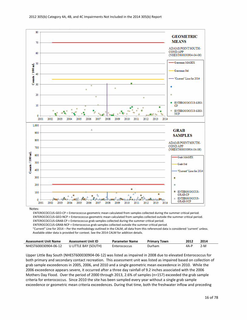
NHEST600030904-06-12 U LITTLE BAY (SOUTH) Enterococcus Durham 4A-P 2-M
Upper Little Bay South (NHEST600030904-06-12) was listed as impaired in 2008 due to elevated Enterococcus for
both primary and secondary contact recreation. This assessment unit was listed as impaired based on collection of
grab sample exceedences in 2005, 2006, and 2010 and a single geometric mean exceedence in 2010. While the
2006 exceedence appears severe, it occurred after a three day rainfall of 9.2 inches associated with the 2006
Mothers Day Flood. Over the period of 2000 through 2013, 2.6% of samples (n=157) exceeded the grab sample
criteria for enterococcus. Since 2010 the site has been sampled every year without a single grab sample
exceedence or geometric mean criteria exceedences. During that time, both the freshwater inflow and preceding

2012 305(b) Category 4A, 4B, and 4C Impairments Not Included in the 2014 305(b) Report
17 of 78
precipitation conditions experienced during the historic grab sample exceedences have been repeated. Since the
last exceedence in 2010, three years and 42 additional grab samples have been collected which have been used to
calculate 28 geometric means and no enterococcus exceedences have occurred.
The 4A impairment of Upper Little Bay South (NHEST600030904-06-12) for both Primary Contact Recreation (i.e.
swimming) and Secondary Contact Recreation due to elevated enterococcus has been removed. Upper Little Bay
South has been placed in Category 2 (Fully Supporting).
Notes:
ENTEROCOCCUS-GEO-CP = Enterococcus geometric mean calculated from samples collected during the summer critical period.
ENTEROCOCCUS-GEO-NCP = Enterococcus geometric mean calculated from samples collected outside the summer critical period.
ENTEROCOCCUS-GRAB-CP = Enterococcus grab samples collected during the summer critical period.
ENTEROCOCCUS-GRAB-NCP = Enterococcus grab samples collected outside the summer critical period.
“Current” Line for 2014 – Per the methodology outlined in the CALM, all data from this referenced data is considered ‘current’ unless.
Available older data is provided for context. See the 2014 CALM for addition details.
Assessment Unit Name Assessment Unit ID Parameter Name Primary Town 2012 2014
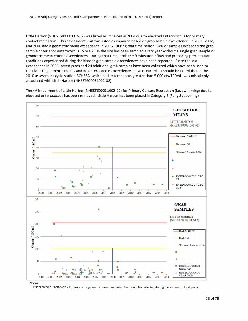
NHEST600031002-02 LITTLE HARBOR Enterococcus Rye 4A-M 2-G
2012 305(b) Category 4A, 4B, and 4C Impairments Not Included in the 2014 305(b) Report
18 of 78
Little Harbor (NHEST600031002-02) was listed as impaired in 2004 due to elevated Enterococcus for primary
contact recreation. This assessment unit was listed as impaired based on grab sample exceedences in 2001, 2002,
and 2006 and a geometric mean exceedence in 2006. During that time period 5.4% of samples exceeded the grab
sample criteria for enterococcus. Since 2006 the site has been sampled every year without a single grab sample or
geometric mean criteria exceedences. During that time, both the freshwater inflow and preceding precipitation
conditions experienced during the historic grab sample exceedences have been repeated. Since the last
exceedence in 2006, seven years and 24 additional grab samples have been collected which have been used to
calculate 10 geometric means and no enterococcus exceedences have occurred. It should be noted that in the
2010 assessment cycle station BCH26A, which had enterococcus greater than 5,000 cts/100mL, was mistakenly
associated with Little Harbor (NHEST600031002-02).
The 4A impairment of Little Harbor (NHEST600031002-02) for Primary Contact Recreation (i.e. swimming) due to
elevated enterococcus has been removed. Little Harbor has been placed in Category 2 (Fully Supporting).
Notes:
ENTEROCOCCUS-GEO-CP = Enterococcus geometric mean calculated from samples collected during the summer critical period.
2012 305(b) Category 4A, 4B, and 4C Impairments Not Included in the 2014 305(b) Report
19 of 78
ENTEROCOCCUS-GEO-NCP = Enterococcus geometric mean calculated from samples collected outside the summer critical period.
ENTEROCOCCUS-GRAB-CP = Enterococcus grab samples collected during the summer critical period.
ENTEROCOCCUS-GRAB-NCP = Enterococcus grab samples collected outside the summer critical period.
“Current” Line for 2014 – Per the methodology outlined in the CALM, all data from this referenced data is considered ‘current’ unless.
Available older data is provided for context. See the 2014 CALM for addition details.
Assessment Unit Name Assessment Unit ID Parameter Name Primary Town 2012 2014
NHOCN000000000-02-06 ATLANTIC OCEAN -
SAWYER BEACH
Enterococcus Rye 4A-P 2-G
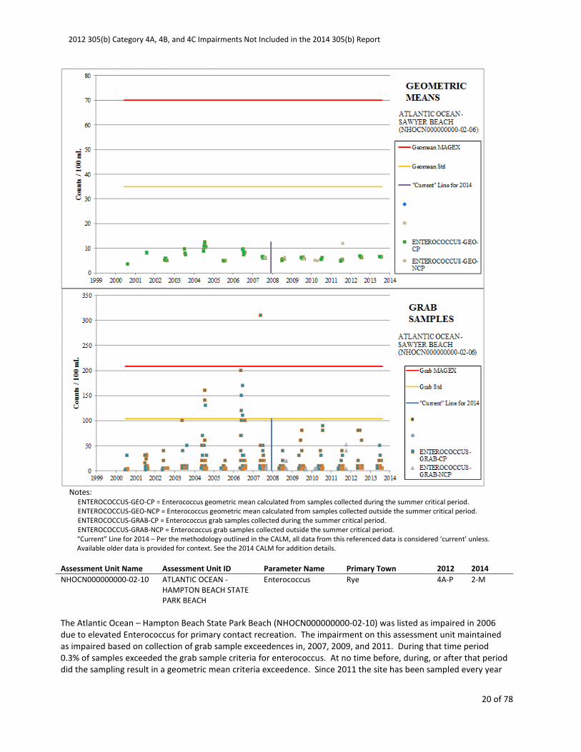
The Atlantic Ocean – Sawyer Beach (NHOCN000000000-02-06) was listed as impaired in 2004 due to elevated
Enterococcus for primary contact recreation. This assessment unit was listed as impaired based on collection of
grab sample exceedences in 2004, 2006, and 2007. During that time period 1.0% of samples exceeded the grab
sample criteria for enterococcus. At no time before, during, or after that period did the sampling result in a
geometric mean criteria exceedence. Since 2007 the site has been sampled every year without any grab sample or
geometric mean criteria exceedences. During that time, both the freshwater inflow and preceding precipitation
conditions experienced during the historic grab sample exceedences have been repeated. Since the last
exceedence in 2007, six years and 631 additional grab samples have been collected which have been used to
calculate 61 geometric means and no enterococcus exceedences have occurred.
The 4A impairment of the Atlantic Ocean – Sawyer Beach (NHOCN000000000-02-06) for Primary Contact
Recreation (i.e. swimming) due to elevated enterococcus has been removed. The Atlantic Ocean – Sawyer Beach
has been placed in Category 2 (Fully Supporting).
2012 305(b) Category 4A, 4B, and 4C Impairments Not Included in the 2014 305(b) Report
20 of 78
Notes:
ENTEROCOCCUS-GEO-CP = Enterococcus geometric mean calculated from samples collected during the summer critical period.
ENTEROCOCCUS-GEO-NCP = Enterococcus geometric mean calculated from samples collected outside the summer critical period.
ENTEROCOCCUS-GRAB-CP = Enterococcus grab samples collected during the summer critical period.
ENTEROCOCCUS-GRAB-NCP = Enterococcus grab samples collected outside the summer critical period.
“Current” Line for 2014 – Per the methodology outlined in the CALM, all data from this referenced data is considered ‘current’ unless.
Available older data is provided for context. See the 2014 CALM for addition details.
Assessment Unit Name Assessment Unit ID Parameter Name Primary Town 2012 2014
NHOCN000000000-02-10 ATLANTIC OCEAN -
HAMPTON BEACH STATE
PARK BEACH
Enterococcus Rye 4A-P 2-M
The Atlantic Ocean – Hampton Beach State Park Beach (NHOCN000000000-02-10) was listed as impaired in 2006
due to elevated Enterococcus for primary contact recreation. The impairment on this assessment unit maintained
as impaired based on collection of grab sample exceedences in, 2007, 2009, and 2011. During that time period
0.3% of samples exceeded the grab sample criteria for enterococcus. At no time before, during, or after that period
did the sampling result in a geometric mean criteria exceedence. Since 2011 the site has been sampled every year
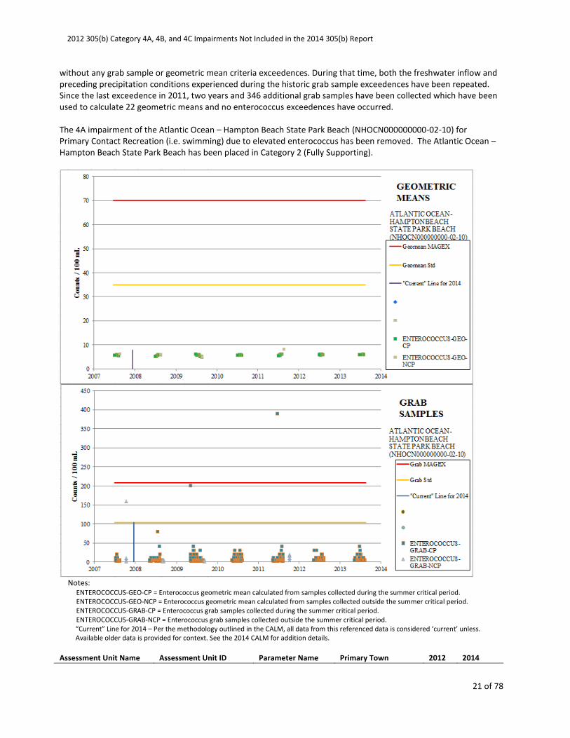
2012 305(b) Category 4A, 4B, and 4C Impairments Not Included in the 2014 305(b) Report
21 of 78
without any grab sample or geometric mean criteria exceedences. During that time, both the freshwater inflow and
preceding precipitation conditions experienced during the historic grab sample exceedences have been repeated.
Since the last exceedence in 2011, two years and 346 additional grab samples have been collected which have been
used to calculate 22 geometric means and no enterococcus exceedences have occurred.
The 4A impairment of the Atlantic Ocean – Hampton Beach State Park Beach (NHOCN000000000-02-10) for
Primary Contact Recreation (i.e. swimming) due to elevated enterococcus has been removed. The Atlantic Ocean –
Hampton Beach State Park Beach has been placed in Category 2 (Fully Supporting).
Notes:
ENTEROCOCCUS-GEO-CP = Enterococcus geometric mean calculated from samples collected during the summer critical period.
ENTEROCOCCUS-GEO-NCP = Enterococcus geometric mean calculated from samples collected outside the summer critical period.
ENTEROCOCCUS-GRAB-CP = Enterococcus grab samples collected during the summer critical period.
ENTEROCOCCUS-GRAB-NCP = Enterococcus grab samples collected outside the summer critical period.
“Current” Line for 2014 – Per the methodology outlined in the CALM, all data from this referenced data is considered ‘current’ unless.
Available older data is provided for context. See the 2014 CALM for addition details.
Assessment Unit Name Assessment Unit ID Parameter Name Primary Town 2012 2014
2012 305(b) Category 4A, 4B, and 4C Impairments Not Included in the 2014 305(b) Report
22 of 78
NHOCN000000000-02-11 ATLANTIC OCEAN -
SEABROOK TOWN BEACH
Enterococcus Seabrook 4A-P 2-M
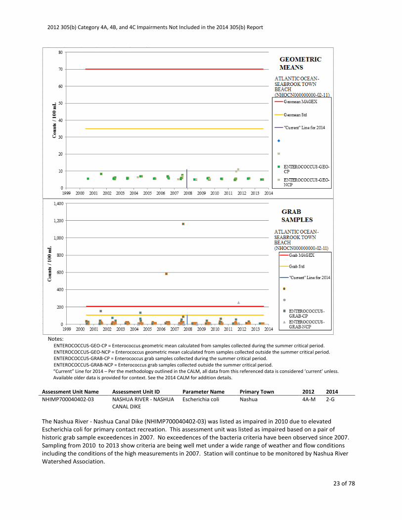
The Atlantic Ocean - Seabrook Town Beach (NHOCN000000000-02-11) was listed as impaired in 2008 due to
elevated Enterococcus for both primary and secondary contact recreation. This assessment unit was listed as
impaired for primary contact recreation based on collection of grab sample exceedences in 2001, 2004, 2006, 2007,
and 2011. During that time period 0.6% of samples exceeded the grab sample criteria for enterococcus. At no time
before, during, or after that period did the sampling result in a geometric mean criteria exceedence. Since 2011 the
site has been sampled every year without any grab sample or geometric mean criteria exceedences. During that
time, both the freshwater inflow and preceding precipitation conditions experienced during the historic grab
sample exceedences have been repeated. Since the last exceedence in 2011, two years and 119 additional grab
samples have been collected which have been used to calculate 13 geometric means and no enterococcus
exceedences have occurred.
This assessment unit was also listed as impaired for secondary contact recreation on collection of grab sample
exceedences in 2006 and 2007. At no time before, during, or after that period did the sampling result in a
geometric mean criteria exceedence. Since the last secondary contact recreation indicator exceedence in 2007 the
site has been sampled every year without any grab sample or geometric mean criteria exceedences. During that
time, both the freshwater inflow and preceding precipitation conditions experienced during the historic grab
sample exceedences have been repeated. Since the last secondary contact recreation indicator exceedence in
2007, six years and 479 additional grab samples have been collected which have been used to calculate 47
geometric means and no enterococcus exceedences have occurred.
The 4A impairment of Atlantic Ocean - Seabrook Town Beach (NHOCN000000000-02-11) for both Primary Contact
Recreation (i.e. swimming) and Secondary Contact Recreation due to elevated enterococcus has been removed.
The Atlantic Ocean - Seabrook Town Beach has been placed in Category 2 (Fully Supporting).
2012 305(b) Category 4A, 4B, and 4C Impairments Not Included in the 2014 305(b) Report
23 of 78
Notes:
ENTEROCOCCUS-GEO-CP = Enterococcus geometric mean calculated from samples collected during the summer critical period.
ENTEROCOCCUS-GEO-NCP = Enterococcus geometric mean calculated from samples collected outside the summer critical period.
ENTEROCOCCUS-GRAB-CP = Enterococcus grab samples collected during the summer critical period.
ENTEROCOCCUS-GRAB-NCP = Enterococcus grab samples collected outside the summer critical period.
“Current” Line for 2014 – Per the methodology outlined in the CALM, all data from this referenced data is considered ‘current’ unless.
Available older data is provided for context. See the 2014 CALM for addition details.
Assessment Unit Name Assessment Unit ID Parameter Name Primary Town 2012 2014
NHIMP700040402-03 NASHUA RIVER - NASHUA
CANAL DIKE
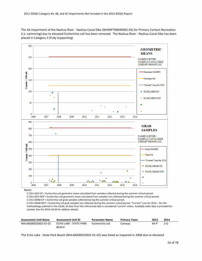
Escherichia coli Nashua 4A-M 2-G
The Nashua River - Nashua Canal Dike (NHIMP700040402-03) was listed as impaired in 2010 due to elevated
Escherichia coli for primary contact recreation. This assessment unit was listed as impaired based on a pair of
historic grab sample exceedences in 2007. No exceedences of the bacteria criteria have been observed since 2007.
Sampling from 2010 to 2013 show criteria are being well met under a wide range of weather and flow conditions
including the conditions of the high measurements in 2007. Station will continue to be monitored by Nashua River
Watershed Association.
2012 305(b) Category 4A, 4B, and 4C Impairments Not Included in the 2014 305(b) Report
24 of 78
The 4A impairment of the Nashua River - Nashua Canal Dike (NHIMP700040402-03) for Primary Contact Recreation
(i.e. swimming) due to elevated Escherichia coli has been removed. The Nashua River - Nashua Canal Dike has been
placed in Category 2 (Fully Supporting).
Notes:
E.COLI-GEO-CP = Escherchia coli geometric mean calculated from samples collected during the summer critical period.
E.COLI-GEO-NCP = Escherchia coli geometric mean calculated from samples not collected during the summer critical period.
E.COLI-GRAB-CP = Escherchia coli grab samples collected during the summer critical period.
E.COLI-GRAB-NCP = Escherchia coli grab samples not collected during the summer critical period. “Current” Line for 2014 – Per the
methodology outlined in the CALM, all data from this referenced data is considered ‘current’ unless. Available older data is provided for
context. See the 2014 CALM for addition details.
Assessment Unit Name Assessment Unit ID Parameter Name Primary Town 2012 2014
NHLAK600020302-01-02 ECHO LAKE - STATE PARK
BEACH
Escherichia coli Conway 4A-P 2-G
The Echo Lake - State Park Beach (NHLAK600020302-01-02) was listed as impaired in 2008 due to elevated

2012 305(b) Category 4A, 4B, and 4C Impairments Not Included in the 2014 305(b) Report
25 of 78
Escherichia coli for primary contact recreation. This assessment unit was listed as impaired based on exceedences
of the grab sample criteria in 2006 and 2008. At no time during that period did the sampling result in a geometric
mean criteria exceedence. Since that time the site has been sampled every year without any grab sample or
geometric mean criteria exceedences. During that time, both the flow and preceding precipitation conditions
experienced during the original high readings have been repeated.
The 4A impairment of the Echo Lake - State Park Beach (NHLAK600020302-01-02) for Primary Contact Recreation
(i.e. swimming) due to elevated Escherichia coli has been removed. The Echo Lake - State Park Beach has been
placed in Category 2 (Fully Supporting).
Notes:
E.COLI-GEO-CP = Escherchia coli geometric mean calculated from samples collected during the summer critical period.
E.COLI-GRAB-CP = Escherchia coli grab samples collected during the summer critical period.
“Current” Line for 2014 – Per the methodology outlined in the CALM, all data from this referenced data is considered ‘current’ unless.
Available older data is provided for context. See the 2014 CALM for addition details.
Assessment Unit Name Assessment Unit ID Parameter Name Primary Town 2012 2014
2012 305(b) Category 4A, 4B, and 4C Impairments Not Included in the 2014 305(b) Report
26 of 78
NHLAK600020605-02-02 WHITE LAKE - STATE PARK
BEACH
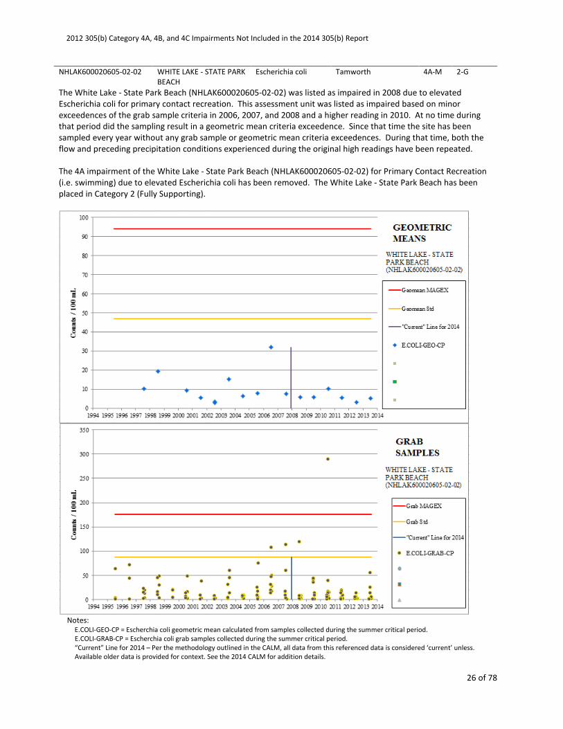
Escherichia coli Tamworth 4A-M 2-G
The White Lake - State Park Beach (NHLAK600020605-02-02) was listed as impaired in 2008 due to elevated
Escherichia coli for primary contact recreation. This assessment unit was listed as impaired based on minor
exceedences of the grab sample criteria in 2006, 2007, and 2008 and a higher reading in 2010. At no time during
that period did the sampling result in a geometric mean criteria exceedence. Since that time the site has been
sampled every year without any grab sample or geometric mean criteria exceedences. During that time, both the
flow and preceding precipitation conditions experienced during the original high readings have been repeated.
The 4A impairment of the White Lake - State Park Beach (NHLAK600020605-02-02) for Primary Contact Recreation
(i.e. swimming) due to elevated Escherichia coli has been removed. The White Lake - State Park Beach has been
placed in Category 2 (Fully Supporting).
Notes:
E.COLI-GEO-CP = Escherchia coli geometric mean calculated from samples collected during the summer critical period.
E.COLI-GRAB-CP = Escherchia coli grab samples collected during the summer critical period.
“Current” Line for 2014 – Per the methodology outlined in the CALM, all data from this referenced data is considered ‘current’ unless.
Available older data is provided for context. See the 2014 CALM for addition details.

2012 305(b) Category 4A, 4B, and 4C Impairments Not Included in the 2014 305(b) Report
27 of 78
Assessment Unit Name Assessment Unit ID Parameter Name Primary Town 2012 2014
NHLAK600030604-01-02 BOW LAKE - TOWN
BEACH
Escherichia coli Strafford 4A-P 2-M
Bow Lake - Town Beach (NHLAK600030604-01-02) was listed as impaired in 2006 due to elevated Escherichia coli
for primary contact recreation. This assessment unit was listed as impaired based on collection of grab sample
exceedences in 1997, 2001, and 2005. At no time before, during, or after that period did the sampling result in a
geometric mean criteria exceedence. Since 2005 the site has been sampled every year without any grab sample or
geometric mean criteria exceedences. During that time, both the flow and preceding precipitation conditions
experienced during the historic grab sample exceedences have been repeated. Since the last exceedence in 2005,
eight years and 73 additional grab samples have been collected which have been used to calculate nine geometric
means and no E. coli exceedences have occurred
The 4A impairment of Bow Lake - Town Beach (NHLAK600030604-01-02) for Primary Contact Recreation (i.e.
swimming) due to elevated Escherichia coli has been removed. Bow Lake - Town Beach has been placed in
Category 2 (Fully Supporting).

2012 305(b) Category 4A, 4B, and 4C Impairments Not Included in the 2014 305(b) Report
28 of 78
Notes:
E.COLI-GEO-CP = Escherchia coli geometric mean calculated from samples collected during the summer critical period.
E.COLI-GRAB-CP = Escherchia coli grab samples collected during the summer critical period.
“Current” Line for 2014 – Per the methodology outlined in the CALM, all data from this referenced data is considered ‘current’ unless.
Available older data is provided for context. See the 2014 CALM for addition details.
Assessment Unit Name Assessment Unit ID Parameter Name Primary Town 2012 2014
NHLAK600030704-02-03 PAWTUCKAWAY LAKE -
TOWN BEACH
Escherichia coli Nottingham 4A-P 2-G
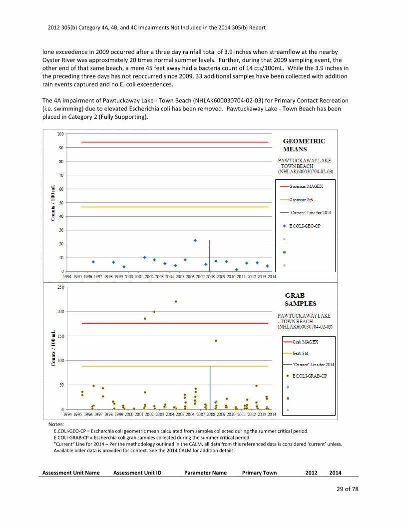
Pawtuckaway Lake - Town Beach (NHLAK600030704-02-03) was listed as impaired in 2004 due to elevated
Escherichia coli for primary contact recreation. This assessment unit was listed as impaired based on collection of
four grab sample exceedences in 2001, 2002, 2004, and 2009. At no time during that period did the sampling result
in a geometric mean criteria exceedence. Since that time the site has been sampled every year without any grab
sample or geometric mean criteria exceedences. During that time, both the flow and preceding precipitation
conditions experienced during the grab sample exceedences of 2001, 2002, and 2004 have been repeated. The
2012 305(b) Category 4A, 4B, and 4C Impairments Not Included in the 2014 305(b) Report
29 of 78
lone exceedence in 2009 occurred after a three day rainfall total of 3.9 inches when streamflow at the nearby
Oyster River was approximately 20 times normal summer levels. Further, during that 2009 sampling event, the
other end of that same beach, a mere 45 feet away had a bacteria count of 14 cts/100mL. While the 3.9 inches in
the preceding three days has not reoccurred since 2009, 33 additional samples have been collected with addition
rain events captured and no E. coli exceedences.
The 4A impairment of Pawtuckaway Lake - Town Beach (NHLAK600030704-02-03) for Primary Contact Recreation
(i.e. swimming) due to elevated Escherichia coli has been removed. Pawtuckaway Lake - Town Beach has been
placed in Category 2 (Fully Supporting).
Notes:
E.COLI-GEO-CP = Escherchia coli geometric mean calculated from samples collected during the summer critical period.
E.COLI-GRAB-CP = Escherchia coli grab samples collected during the summer critical period.
“Current” Line for 2014 – Per the methodology outlined in the CALM, all data from this referenced data is considered ‘current’ unless.
Available older data is provided for context. See the 2014 CALM for addition details.
Assessment Unit Name Assessment Unit ID Parameter Name Primary Town 2012 2014
2012 305(b) Category 4A, 4B, and 4C Impairments Not Included in the 2014 305(b) Report
30 of 78
NHLAK700010502-01-02 LITTLE SQUAM LAKE -
TOWN BEACH
Escherichia coli Ashland 4A-P 2-G
Little Squam Lake - Town Beach (NHLAK700010502-01-02) was listed as impaired in 2004 due to elevated
Escherichia coli for primary contact recreation. This assessment unit was listed as impaired based on collection of
grab sample exceedences in 2003 and maintained as impaired based on high values in 2006, and 2008. At no time
during that period did the sampling result in a geometric mean criteria exceedence. Since that time the site has
been sampled every year without any grab sample or geometric mean criteria exceedences. During that time, both
the flow and preceding precipitation conditions experienced during the grab sample exceedences of 2003 and 2006
have been repeated. The exceedences in 2008 all occurred on August 6 and 8, 2008 after a three day rainfall total
of 0.7 to 3.25 inches when streamflow at the nearby Baker River was 10-15 times normal summer levels. While the
3.25 inches in the preceding three days has not reoccurred since 2008, five years and 75 additional samples have
been collected with addition rain events captured and no E. coli exceedences.
The 4A impairment of Little Squam Lake - Town Beach (NHLAK700010502-01-02) for Primary Contact Recreation
(i.e. swimming) due to elevated Escherichia coli has been removed. Little Squam Lake - Town Beach has been
placed in Category 2 (Fully Supporting).
2012 305(b) Category 4A, 4B, and 4C Impairments Not Included in the 2014 305(b) Report
31 of 78
Notes:
E.COLI-GEO-CP = Escherchia coli geometric mean calculated from samples collected during the summer critical period.
E.COLI-GRAB-CP = Escherchia coli grab samples collected during the summer critical period.
“Current” Line for 2014 – Per the methodology outlined in the CALM, all data from this referenced data is considered ‘current’ unless.
Available older data is provided for context. See the 2014 CALM for addition details.
Assessment Unit Name Assessment Unit ID Parameter Name Primary Town 2012 2014
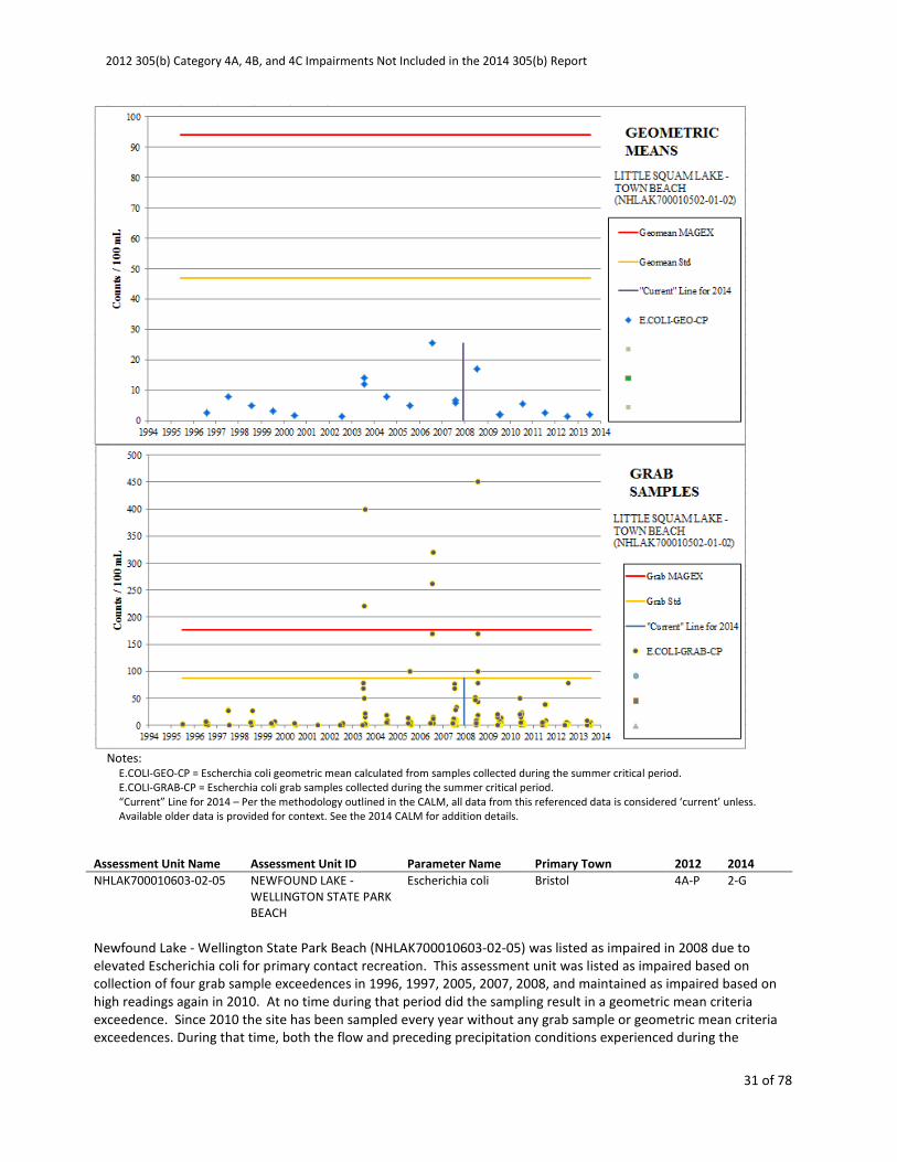
NHLAK700010603-02-05 NEWFOUND LAKE -
WELLINGTON STATE PARK
BEACH
Escherichia coli Bristol 4A-P 2-G
Newfound Lake - Wellington State Park Beach (NHLAK700010603-02-05) was listed as impaired in 2008 due to
elevated Escherichia coli for primary contact recreation. This assessment unit was listed as impaired based on
collection of four grab sample exceedences in 1996, 1997, 2005, 2007, 2008, and maintained as impaired based on
high readings again in 2010. At no time during that period did the sampling result in a geometric mean criteria
exceedence. Since 2010 the site has been sampled every year without any grab sample or geometric mean criteria
exceedences. During that time, both the flow and preceding precipitation conditions experienced during the
2012 305(b) Category 4A, 4B, and 4C Impairments Not Included in the 2014 305(b) Report
32 of 78
historic grab sample exceedences have been repeated. Since the last exceedence in 2010, five years and 32
additional grab samples have been collected which have been used to calculate five geometric means and no E. coli
exceedences have occurred.
The 4A impairment of Newfound Lake - Wellington State Park Beach (NHLAK700010603-02-05) for Primary Contact
Recreation (i.e. swimming) due to elevated Escherichia coli has been removed. Newfound Lake - Wellington State
Park Beach has been placed in Category 2 (Fully Supporting).
Notes:
E.COLI-GEO-CP = Escherchia coli geometric mean calculated from samples collected during the summer critical period.
E.COLI-GRAB-CP = Escherchia coli grab samples collected during the summer critical period.
“Current” Line for 2014 – Per the methodology outlined in the CALM, all data from this referenced data is considered ‘current’ unless.
Available older data is provided for context. See the 2014 CALM for addition details.
Assessment Unit Name Assessment Unit ID Parameter Name Primary Town 2012 2014
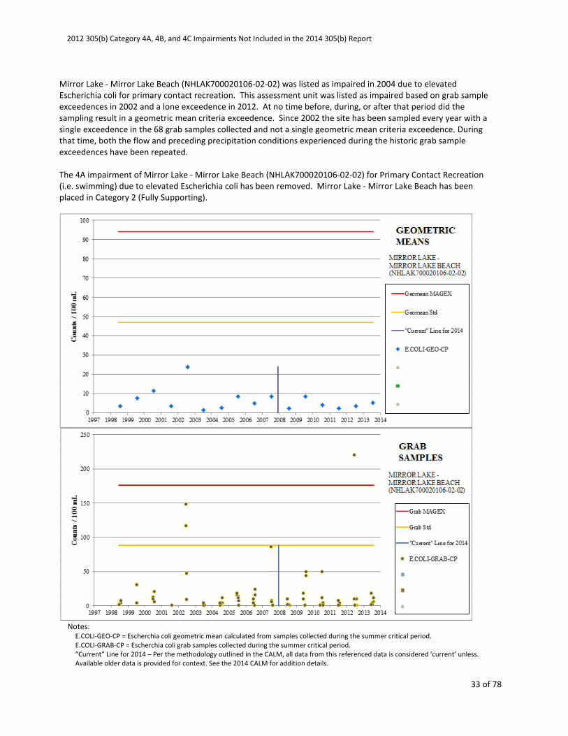
NHLAK700020106-02-02 MIRROR LAKE - MIRROR
LAKE BEACH
Escherichia coli Tuftonboro 4A-M 2-M
2012 305(b) Category 4A, 4B, and 4C Impairments Not Included in the 2014 305(b) Report
33 of 78
Mirror Lake - Mirror Lake Beach (NHLAK700020106-02-02) was listed as impaired in 2004 due to elevated
Escherichia coli for primary contact recreation. This assessment unit was listed as impaired based on grab sample
exceedences in 2002 and a lone exceedence in 2012. At no time before, during, or after that period did the
sampling result in a geometric mean criteria exceedence. Since 2002 the site has been sampled every year with a
single exceedence in the 68 grab samples collected and not a single geometric mean criteria exceedence. During
that time, both the flow and preceding precipitation conditions experienced during the historic grab sample
exceedences have been repeated.
The 4A impairment of Mirror Lake - Mirror Lake Beach (NHLAK700020106-02-02) for Primary Contact Recreation
(i.e. swimming) due to elevated Escherichia coli has been removed. Mirror Lake - Mirror Lake Beach has been
placed in Category 2 (Fully Supporting).
Notes:
E.COLI-GEO-CP = Escherchia coli geometric mean calculated from samples collected during the summer critical period.
E.COLI-GRAB-CP = Escherchia coli grab samples collected during the summer critical period.
“Current” Line for 2014 – Per the methodology outlined in the CALM, all data from this referenced data is considered ‘current’ unless.
Available older data is provided for context. See the 2014 CALM for addition details.
2012 305(b) Category 4A, 4B, and 4C Impairments Not Included in the 2014 305(b) Report
34 of 78
Assessment Unit Name Assessment Unit ID Parameter Name Primary Town 2012 2014
NHLAK700020110-02-11 LAKE WINNIPESAUKEE -
PUBLIC DOCK TOWN
BEACH
Escherichia coli Alton 4A-P 2-G
Lake Winnipesaukee - Public Dock Town Beach (NHLAK700020110-02-11) was listed as impaired in 2008 due to
elevated Escherichia coli for primary contact recreation. This assessment unit was listed as impaired based on
collection of four grab sample exceedences in 1996, 1998, and 2006. At no time during that period did the
sampling result in a geometric mean criteria exceedence. Since 2006 the site has been sampled every year without
any grab sample or geometric mean criteria exceedences. During that time, both the flow and preceding
precipitation conditions experienced during the historic grab sample exceedences have been repeated. Since the
last exceedence in 2006, seven years and 67 additional grab samples have been collected which have been used to
calculate eight geometric means and no E. coli exceedences have occurred.
The 4A impairment of Lake Winnipesaukee - Public Dock Town Beach (NHLAK700020110-02-11) for Primary
Contact Recreation (i.e. swimming) due to elevated Escherichia coli has been removed. Lake Winnipesaukee -
Public Dock Town Beach has been placed in Category 2 (Fully Supporting).
2012 305(b) Category 4A, 4B, and 4C Impairments Not Included in the 2014 305(b) Report
35 of 78
Notes:
E.COLI-GEO-CP = Escherchia coli geometric mean calculated from samples collected during the summer critical period.
E.COLI-GRAB-CP = Escherchia coli grab samples collected during the summer critical period.
“Current” Line for 2014 – Per the methodology outlined in the CALM, all data from this referenced data is considered ‘current’ unless.
Available older data is provided for context. See the 2014 CALM for addition details.
Assessment Unit Name Assessment Unit ID Parameter Name Primary Town 2012 2014
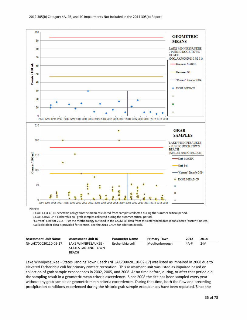
NHLAK700020110-02-17 LAKE WINNIPESAUKEE -
STATES LANDING TOWN
BEACH
Escherichia coli Moultonborough 4A-P 2-M
Lake Winnipesaukee - States Landing Town Beach (NHLAK700020110-02-17) was listed as impaired in 2008 due to
elevated Escherichia coli for primary contact recreation. This assessment unit was listed as impaired based on
collection of grab sample exceedences in 2002, 2005, and 2008. At no time before, during, or after that period did
the sampling result in a geometric mean criteria exceedence. Since 2008 the site has been sampled every year
without any grab sample or geometric mean criteria exceedences. During that time, both the flow and preceding
precipitation conditions experienced during the historic grab sample exceedences have been repeated. Since the
2012 305(b) Category 4A, 4B, and 4C Impairments Not Included in the 2014 305(b) Report
36 of 78
last exceedence in 2008, five years and 37 additional grab samples have been collected which have been used to
calculate six geometric means and no E. coli exceedences have occurred.
The 4A impairment of Lake Winnipesaukee - States Landing Town Beach (NHLAK700020110-02-17) for Primary
Contact Recreation (i.e. swimming) due to elevated Escherichia coli has been removed. Lake Winnipesaukee -
States Landing Town Beach has been placed in Category 2 (Fully Supporting).
Notes:
E.COLI-GEO-CP = Escherchia coli geometric mean calculated from samples collected during the summer critical period.
E.COLI-GRAB-CP = Escherchia coli grab samples collected during the summer critical period.
E.COLI-GRAB-NCP = Escherchia coli grab samples collected outside the summer critical period.
“Current” Line for 2014 – Per the methodology outlined in the CALM, all data from this referenced data is considered ‘current’ unless.
Available older data is provided for context. See the 2014 CALM for addition details.
Assessment Unit Name Assessment Unit ID Parameter Name Primary Town 2012 2014
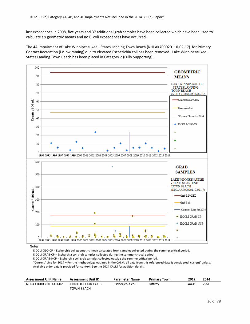
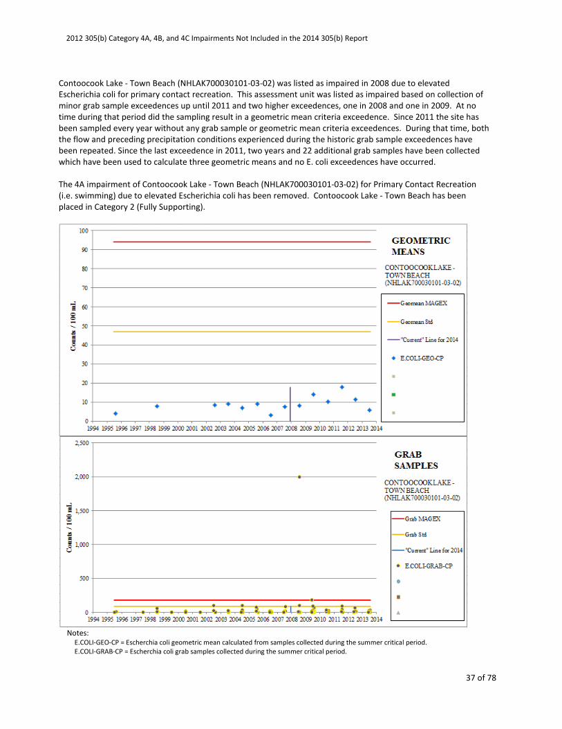
NHLAK700030101-03-02 CONTOOCOOK LAKE -
TOWN BEACH
Escherichia coli Jaffrey 4A-P 2-M
2012 305(b) Category 4A, 4B, and 4C Impairments Not Included in the 2014 305(b) Report
37 of 78
Contoocook Lake - Town Beach (NHLAK700030101-03-02) was listed as impaired in 2008 due to elevated
Escherichia coli for primary contact recreation. This assessment unit was listed as impaired based on collection of
minor grab sample exceedences up until 2011 and two higher exceedences, one in 2008 and one in 2009. At no
time during that period did the sampling result in a geometric mean criteria exceedence. Since 2011 the site has
been sampled every year without any grab sample or geometric mean criteria exceedences. During that time, both
the flow and preceding precipitation conditions experienced during the historic grab sample exceedences have
been repeated. Since the last exceedence in 2011, two years and 22 additional grab samples have been collected
which have been used to calculate three geometric means and no E. coli exceedences have occurred.
The 4A impairment of Contoocook Lake - Town Beach (NHLAK700030101-03-02) for Primary Contact Recreation
(i.e. swimming) due to elevated Escherichia coli has been removed. Contoocook Lake - Town Beach has been
placed in Category 2 (Fully Supporting).
Notes:
E.COLI-GEO-CP = Escherchia coli geometric mean calculated from samples collected during the summer critical period.
E.COLI-GRAB-CP = Escherchia coli grab samples collected during the summer critical period.
2012 305(b) Category 4A, 4B, and 4C Impairments Not Included in the 2014 305(b) Report
38 of 78
“Current” Line for 2014 – Per the methodology outlined in the CALM, all data from this referenced data is considered ‘current’ unless.
Available older data is provided for context. See the 2014 CALM for addition details.
Assessment Unit Name Assessment Unit ID Parameter Name Primary Town 2012 2014
NHLAK700030107-02-02 NORWAY POND - TOWN
BEACH
Escherichia coli Hancock 4A-P 2-M
Norway Pond - Town Beach (NHLAK700030107-02-02) was listed as impaired in 2004 due to elevated Escherichia
coli for primary contact recreation. This assessment unit was listed as impaired based on collection of grab sample
exceedences from 2003 and maintained as impaired based on exceedences in 2009 with the exceedences of 2009
triggering a geometric mean exceedence. At no time besides 2009 during that period did the sampling result in a
geometric mean criteria exceedence. Since 2009 the site has been sampled every year without any grab sample or
geometric mean criteria exceedences. During that time, both the flow and preceding precipitation conditions
experienced during the historic grab sample exceedences have been repeated. Since the last exceedence in 2009,
four years and 33 additional grab samples have been collected which have been used to calculate six geometric
means and no E. coli exceedences have occurred.
The 4A impairment of Norway Pond - Town Beach (NHLAK700030107-02-02) for Primary Contact Recreation (i.e.
swimming) due to elevated Escherichia coli has been removed. Norway Pond - Town Beach has been placed in
Category 2 (Fully Supporting).
2012 305(b) Category 4A, 4B, and 4C Impairments Not Included in the 2014 305(b) Report
39 of 78
Notes:
E.COLI-GEO-CP = Escherchia coli geometric mean calculated from samples collected during the summer critical period.
E.COLI-GEO-NCP = Escherchia coli geometric mean calculated from samples collected outside the summer critical period.
E.COLI-GRAB-CP = Escherchia coli grab samples collected during the summer critical period.
E.COLI-GRAB-NCP = Escherchia coli grab samples collected outside the summer critical period.
“Current” Line for 2014 – Per the methodology outlined in the CALM, all data from this referenced data is considered ‘current’ unless.
Available older data is provided for context. See the 2014 CALM for addition details.
Assessment Unit Name Assessment Unit ID Parameter Name Primary Town 2012 2014
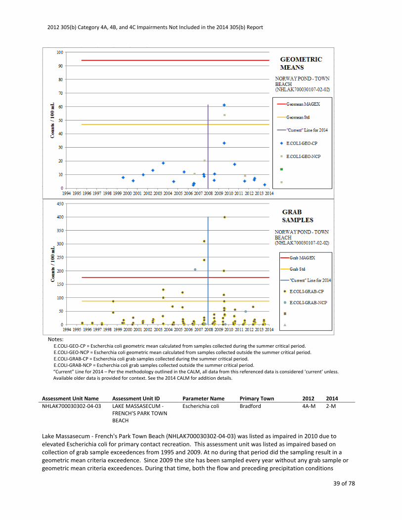
NHLAK700030302-04-03 LAKE MASSASECUM -
FRENCH'S PARK TOWN
BEACH
Escherichia coli Bradford 4A-M 2-M
Lake Massasecum - French's Park Town Beach (NHLAK700030302-04-03) was listed as impaired in 2010 due to
elevated Escherichia coli for primary contact recreation. This assessment unit was listed as impaired based on
collection of grab sample exceedences from 1995 and 2009. At no during that period did the sampling result in a
geometric mean criteria exceedence. Since 2009 the site has been sampled every year without any grab sample or
geometric mean criteria exceedences. During that time, both the flow and preceding precipitation conditions
2012 305(b) Category 4A, 4B, and 4C Impairments Not Included in the 2014 305(b) Report
40 of 78
experienced during the historic grab sample exceedences have been repeated. Since the last exceedence in 2009,
four years and 36 additional grab samples have been collected which have been used to calculate five geometric
means and no E. coli exceedences have occurred.
The 4A impairment of Lake Massasecum - French's Park Town Beach (NHLAK700030302-04-03) for Primary Contact
Recreation (i.e. swimming) due to elevated Escherichia coli has been removed. Lake Massasecum - French's Park
Town Beach has been placed in Category 2 (Fully Supporting).
Notes:
E.COLI-GEO-CP = Escherchia coli geometric mean calculated from samples collected during the summer critical period.
E.COLI-GRAB-CP = Escherchia coli grab samples collected during the summer critical period.
“Current” Line for 2014 – Per the methodology outlined in the CALM, all data from this referenced data is considered ‘current’ unless.
Available older data is provided for context. See the 2014 CALM for addition details.
Assessment Unit Name Assessment Unit ID Parameter Name Primary Town 2012 2014
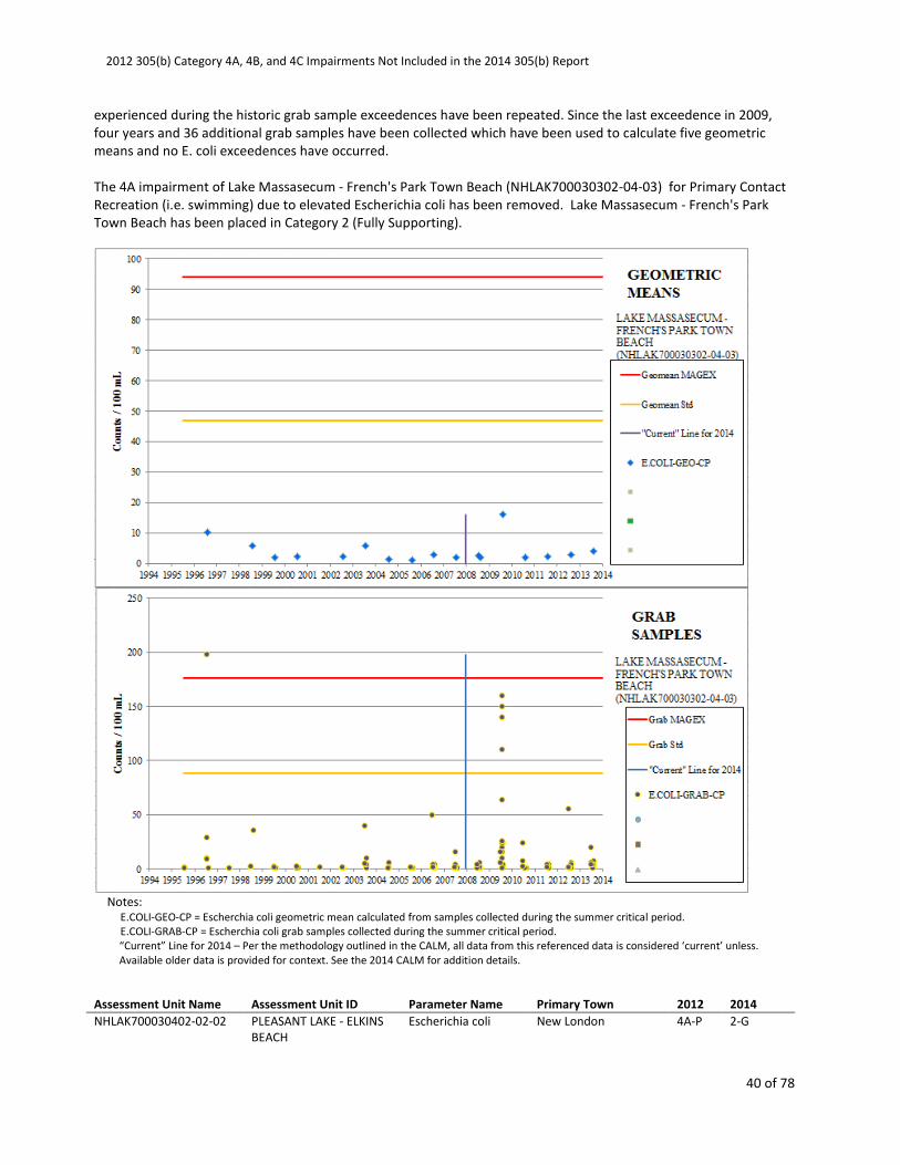
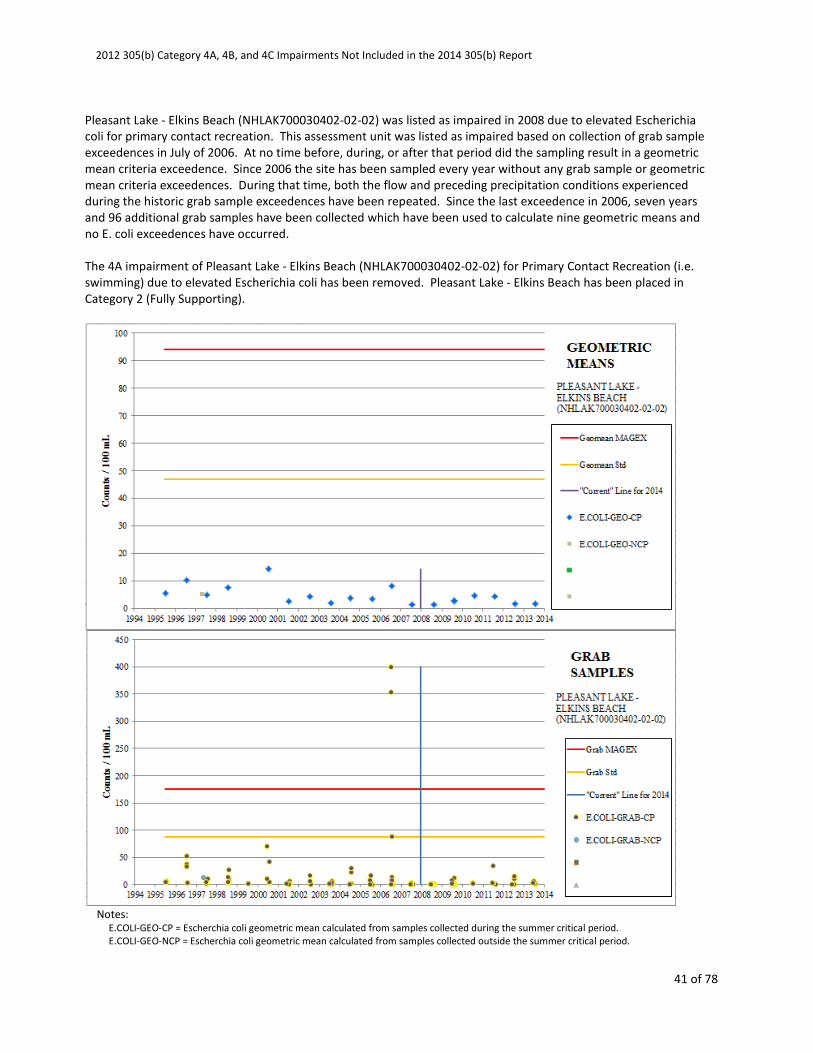
NHLAK700030402-02-02 PLEASANT LAKE - ELKINS
BEACH
Escherichia coli New London 4A-P 2-G
2012 305(b) Category 4A, 4B, and 4C Impairments Not Included in the 2014 305(b) Report
41 of 78
Pleasant Lake - Elkins Beach (NHLAK700030402-02-02) was listed as impaired in 2008 due to elevated Escherichia
coli for primary contact recreation. This assessment unit was listed as impaired based on collection of grab sample
exceedences in July of 2006. At no time before, during, or after that period did the sampling result in a geometric
mean criteria exceedence. Since 2006 the site has been sampled every year without any grab sample or geometric
mean criteria exceedences. During that time, both the flow and preceding precipitation conditions experienced
during the historic grab sample exceedences have been repeated. Since the last exceedence in 2006, seven years
and 96 additional grab samples have been collected which have been used to calculate nine geometric means and
no E. coli exceedences have occurred.
The 4A impairment of Pleasant Lake - Elkins Beach (NHLAK700030402-02-02) for Primary Contact Recreation (i.e.
swimming) due to elevated Escherichia coli has been removed. Pleasant Lake - Elkins Beach has been placed in
Category 2 (Fully Supporting).
Notes:
E.COLI-GEO-CP = Escherchia coli geometric mean calculated from samples collected during the summer critical period.
E.COLI-GEO-NCP = Escherchia coli geometric mean calculated from samples collected outside the summer critical period.

2012 305(b) Category 4A, 4B, and 4C Impairments Not Included in the 2014 305(b) Report
42 of 78
E.COLI-GRAB-CP = Escherchia coli grab samples collected during the summer critical period.
E.COLI-GRAB-NCP = Escherchia coli grab samples collected outside the summer critical period.
“Current” Line for 2014 – Per the methodology outlined in the CALM, all data from this referenced data is considered ‘current’ unless.
Available older data is provided for context. See the 2014 CALM for addition details.
Assessment Unit Name Assessment Unit ID Parameter Name Primary Town 2012 2014
NHLAK700040401-01-02 MELENDY POND - TOWN
BEACH
Escherichia coli Brookline 4A-P 2-G
Melendy Pond - Town Beach (NHLAK700040401-01-02) was listed as impaired in 2002 due to elevated Escherichia
coli for primary contact recreation. This assessment unit was listed as impaired, and maintained as such, based on
collection of grab sample exceedences in 2000, 2001, and 2006. At no time before, during, or after that period did
the sampling result in a geometric mean criteria exceedence. Since 2006 the site has been sampled every year
without any grab sample or geometric mean criteria exceedences. During that time, both the flow and preceding
precipitation conditions experienced during the historic grab sample exceedences have been repeated. Since the
last exceedence in 2006, seven years and 43 additional grab samples have been collected which have been used to
calculate eight geometric means and no E. coli exceedences have occurred.
The 4A impairment of Melendy Pond - Town Beach (NHLAK700040401-01-02) for Primary Contact Recreation (i.e.
swimming) due to elevated Escherichia coli has been removed. Melendy Pond - Town Beach has been placed in
Category 2 (Fully Supporting).
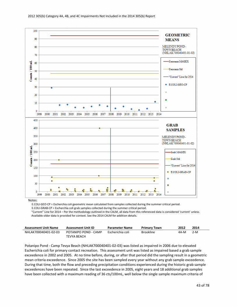
2012 305(b) Category 4A, 4B, and 4C Impairments Not Included in the 2014 305(b) Report
43 of 78
Notes:
E.COLI-GEO-CP = Escherchia coli geometric mean calculated from samples collected during the summer critical period.
E.COLI-GRAB-CP = Escherchia coli grab samples collected during the summer critical period. “Current” Line for 2014 – Per the methodology outlined in the CALM, all data from this referenced data is considered ‘current’ unless.
Available older data is provided for context. See the 2014 CALM for addition details.
Assessment Unit Name Assessment Unit ID Parameter Name Primary Town 2012 2014
NHLAK700040401-02-03 POTANIPO POND - CAMP
TEVYA BEACH
Escherichia coli Brookline 4A-M 2-M
Potanipo Pond - Camp Tevya Beach (NHLAK700040401-02-03) was listed as impaired in 2006 due to elevated
Escherichia coli for primary contact recreation. This assessment unit was listed as impaired based a grab sample
exceedence in 2002 and 2005. At no time before, during, or after that period did the sampling result in a geometric
mean criteria exceedence. Since 2005 the site has been sampled every year without any grab sample exceedence.
During that time, both the flow and preceding precipitation conditions experienced during the historic grab sample
exceedences have been repeated. Since the last exceedence in 2005, eight years and 18 additional grab samples
have been collected with a maximum reading of 36 cts/100mL, well below the single sample maximum criteria of

2012 305(b) Category 4A, 4B, and 4C Impairments Not Included in the 2014 305(b) Report
44 of 78
88 cts/100mL and below the geometric mean criteria of 47 cts/100mL.
The 4A impairment of Potanipo Pond - Camp Tevya Beach (NHLAK700040401-02-03) for Primary Contact
Recreation (i.e. swimming) due to elevated Escherichia coli has been removed. Potanipo Pond - Camp Tevya Beach
has been placed in Category 2 (Fully Supporting).
Notes:
E.COLI-GEO-CP = Escherchia coli geometric mean calculated from samples collected during the summer critical period.
E.COLI-GRAB-CP = Escherchia coli grab samples collected during the summer critical period.
“Current” Line for 2014 – Per the methodology outlined in the CALM, all data from this referenced data is considered ‘current’ unless.
Available older data is provided for context. See the 2014 CALM for addition details.
Assessment Unit Name Assessment Unit ID Parameter Name Primary Town 2012 2014
NHLAK700060502-08-04 NORTHWOOD LAKE -
LYNN GROVE
ASSOCIATION BEACH
Escherichia coli Northwood 4A-P 2-G

2012 305(b) Category 4A, 4B, and 4C Impairments Not Included in the 2014 305(b) Report
45 of 78
Northwood Lake - Lynn Grove Association Beach (NHLAK700060502-08-04) was listed as impaired in 2010 due to
elevated Escherichia coli for primary contact recreation. This assessment unit was listed as impaired based on
collection of grab sample exceedences in 2006. At no time before, during, or after that period did the sampling
result in a geometric mean criteria exceedence. Since 2006 the site has been sampled every year without any grab
sample or geometric mean criteria exceedences. During that time, both the flow and preceding precipitation
conditions experienced during the historic grab sample exceedences have been repeated. Since the last
exceedence in 2006, seven years and 41 additional grab samples have been collected which have been used to
calculate eight geometric means and no E. coli exceedences have occurred.
The 4A impairment of Northwood Lake - Lynn Grove Association Beach (NHLAK700060502-08-04) for Primary
Contact Recreation (i.e. swimming) due to elevated Escherichia coli has been removed. Northwood Lake - Lynn
Grove Association Beach has been placed in Category 2 (Fully Supporting).
Notes:
E.COLI-GEO-CP = Escherchia coli geometric mean calculated from samples collected during the summer critical period.
E.COLI-GRAB-CP = Escherchia coli grab samples collected during the summer critical period.
“Current” Line for 2014 – Per the methodology outlined in the CALM, all data from this referenced data is considered ‘current’ unless.
Available older data is provided for context. See the 2014 CALM for addition details.
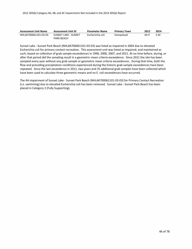
2012 305(b) Category 4A, 4B, and 4C Impairments Not Included in the 2014 305(b) Report
46 of 78
Assessment Unit Name Assessment Unit ID Parameter Name Primary Town 2012 2014
NHLAK700061101-03-03 SUNSET LAKE - SUNSET
PARK BEACH
Escherichia coli Hampstead 4A-P 2-M
Sunset Lake - Sunset Park Beach (NHLAK700061101-03-03) was listed as impaired in 2004 due to elevated
Escherichia coli for primary contact recreation. This assessment unit was listed as impaired, and maintained as
such, based on collection of grab sample exceedences in 1996, 2006, 2007, and 2011. At no time before, during, or
after that period did the sampling result in a geometric mean criteria exceedence. Since 2011 the site has been
sampled every year without any grab sample or geometric mean criteria exceedences. During that time, both the
flow and preceding precipitation conditions experienced during the historic grab sample exceedences have been
repeated. Since the last exceedence in 2011, two years and 25 additional grab samples have been collected which
have been used to calculate three geometric means and no E. coli exceedences have occurred.
The 4A impairment of Sunset Lake - Sunset Park Beach (NHLAK700061101-03-03) for Primary Contact Recreation
(i.e. swimming) due to elevated Escherichia coli has been removed. Sunset Lake - Sunset Park Beach has been
placed in Category 2 (Fully Supporting).
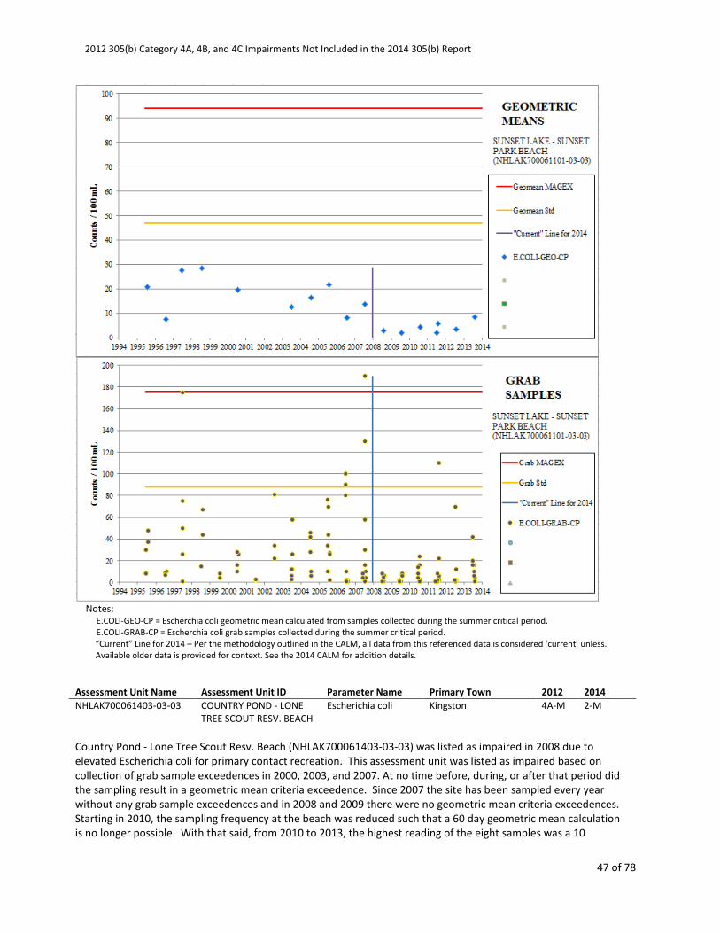
2012 305(b) Category 4A, 4B, and 4C Impairments Not Included in the 2014 305(b) Report
47 of 78
Notes:
E.COLI-GEO-CP = Escherchia coli geometric mean calculated from samples collected during the summer critical period.
E.COLI-GRAB-CP = Escherchia coli grab samples collected during the summer critical period.
“Current” Line for 2014 – Per the methodology outlined in the CALM, all data from this referenced data is considered ‘current’ unless.
Available older data is provided for context. See the 2014 CALM for addition details.
Assessment Unit Name Assessment Unit ID Parameter Name Primary Town 2012 2014
NHLAK700061403-03-03 COUNTRY POND - LONE
TREE SCOUT RESV. BEACH
Escherichia coli Kingston 4A-M 2-M
Country Pond - Lone Tree Scout Resv. Beach (NHLAK700061403-03-03) was listed as impaired in 2008 due to
elevated Escherichia coli for primary contact recreation. This assessment unit was listed as impaired based on
collection of grab sample exceedences in 2000, 2003, and 2007. At no time before, during, or after that period did
the sampling result in a geometric mean criteria exceedence. Since 2007 the site has been sampled every year
without any grab sample exceedences and in 2008 and 2009 there were no geometric mean criteria exceedences.
Starting in 2010, the sampling frequency at the beach was reduced such that a 60 day geometric mean calculation
is no longer possible. With that said, from 2010 to 2013, the highest reading of the eight samples was a 10
2012 305(b) Category 4A, 4B, and 4C Impairments Not Included in the 2014 305(b) Report
48 of 78
cts/100mL, 9 times lower than the grab sample criteria and 5 times lower than geometric mean criteria. Since
2007, both the flow and preceding precipitation conditions experienced during the historic grab sample
exceedences have been repeated.
The 4A impairment of Country Pond - Lone Tree Scout Resv. Beach (NHLAK700061403-03-03) for Primary Contact
Recreation (i.e. swimming) due to elevated Escherichia coli has been removed. Country Pond - Lone Tree Scout
Resv. Beach has been placed in Category 2 (Fully Supporting).
Notes:
E.COLI-GEO-CP = Escherchia coli geometric mean calculated from samples collected during the summer critical period.
E.COLI-GEO-NCP = Escherchia coli geometric mean calculated from samples collected outside the summer critical period.
E.COLI-GRAB-CP = Escherchia coli grab samples collected during the summer critical period.
E.COLI-GRAB-NCP = Escherchia coli grab samples collected outside the summer critical period.
“Current” Line for 2014 – Per the methodology outlined in the CALM, all data from this referenced data is considered ‘current’ unless.
Available older data is provided for context. See the 2014 CALM for addition details.
Assessment Unit Name Assessment Unit ID Parameter Name Primary Town 2012 2014

2012 305(b) Category 4A, 4B, and 4C Impairments Not Included in the 2014 305(b) Report
49 of 78
NHLAK801030101-01-02 BURNS POND - PUBLIC
BEACH
Escherichia coli Whitefield 4A-P 2-M
Burns Pond - Public Beach (NHLAK801030101-01-02) was listed as impaired in 2008 due to elevated Escherichia coli
for primary contact recreation. This assessment unit was listed as impaired based on collection of grab sample
exceedences in 2006, 2007, and 2008 and a geometric mean exceedence in 2006. At no time since 2006 have the
sampling results led to a geometric mean criteria exceedence. Since 2008 the site has been sampled every year
without any grab sample or geometric mean criteria exceedences. During that time, both the flow and preceding
precipitation conditions experienced during the historic exceedences have been repeated. Since the last
exceedence in 2008, five years and 30 additional grab samples have been collected which have been used to
calculate five geometric means and no E. coli exceedences have occurred.
The 4A impairment of Burns Pond - Public Beach (NHLAK801030101-01-02) for Primary Contact Recreation (i.e.
swimming) due to elevated Escherichia coli has been removed. Burns Pond - Public Beach has been placed in
Category 2 (Fully Supporting).
Notes:

2012 305(b) Category 4A, 4B, and 4C Impairments Not Included in the 2014 305(b) Report
50 of 78
E.COLI-GEO-CP = Escherchia coli geometric mean calculated from samples collected during the summer critical period.
E.COLI-GRAB-CP = Escherchia coli grab samples collected during the summer critical period.
“Current” Line for 2014 – Per the methodology outlined in the CALM, all data from this referenced data is considered ‘current’ unless.
Available older data is provided for context. See the 2014 CALM for addition details.
Assessment Unit Name Assessment Unit ID Parameter Name Primary Town 2012 2014
NHLAK801030101-02-02 FOREST LAKE - FOREST
LAKE STATE PARK
Escherichia coli Dalton 4A-P 2-G
Forest Lake - Forest Lake State Park (NHLAK801030101-02-02) was listed as impaired in 2008 due to elevated
Escherichia coli for primary contact recreation. This assessment unit was listed as impaired based on collection of
grab sample exceedences in 2001 and 2006 and a geometric mean exceedence in 2001. At no time since 2001 have
the sampling results led to a geometric mean criteria exceedence. Since 2008 the site has been sampled every year
without any grab sample or geometric mean criteria exceedences. During that time, both the flow and preceding
precipitation conditions experienced during the historic exceedences have been repeated. Since the last
exceedence in 2006, seven years and 59 additional grab samples have been collected which have been used to
calculate eight geometric means and no E. coli exceedences have occurred.
The 4A impairment of Forest Lake - Forest Lake State Park (NHLAK801030101-02-02) for Primary Contact
Recreation (i.e. swimming) due to elevated Escherichia coli has been removed. Forest Lake - Forest Lake State Park
has been placed in Category 2 (Fully Supporting).
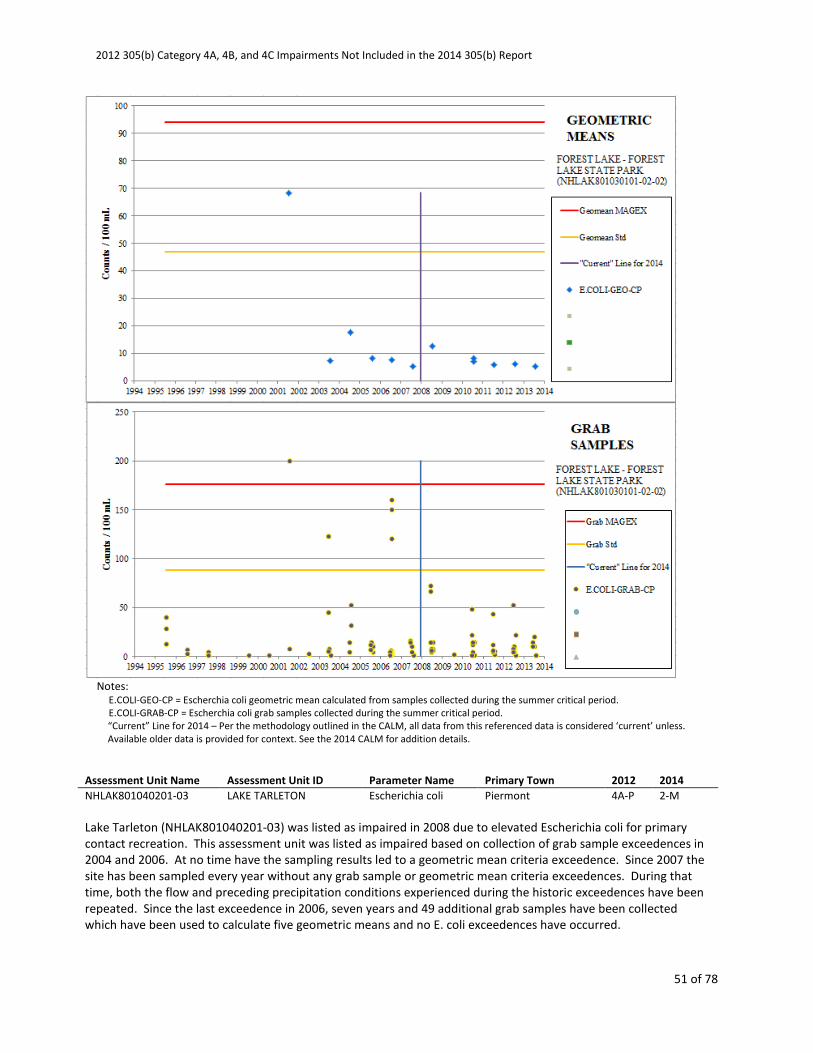
2012 305(b) Category 4A, 4B, and 4C Impairments Not Included in the 2014 305(b) Report
51 of 78
Notes:
E.COLI-GEO-CP = Escherchia coli geometric mean calculated from samples collected during the summer critical period.
E.COLI-GRAB-CP = Escherchia coli grab samples collected during the summer critical period.
“Current” Line for 2014 – Per the methodology outlined in the CALM, all data from this referenced data is considered ‘current’ unless.
Available older data is provided for context. See the 2014 CALM for addition details.
Assessment Unit Name Assessment Unit ID Parameter Name Primary Town 2012 2014
NHLAK801040201-03 LAKE TARLETON Escherichia coli Piermont 4A-P 2-M
Lake Tarleton (NHLAK801040201-03) was listed as impaired in 2008 due to elevated Escherichia coli for primary
contact recreation. This assessment unit was listed as impaired based on collection of grab sample exceedences in
2004 and 2006. At no time have the sampling results led to a geometric mean criteria exceedence. Since 2007 the
site has been sampled every year without any grab sample or geometric mean criteria exceedences. During that
time, both the flow and preceding precipitation conditions experienced during the historic exceedences have been
repeated. Since the last exceedence in 2006, seven years and 49 additional grab samples have been collected
which have been used to calculate five geometric means and no E. coli exceedences have occurred.
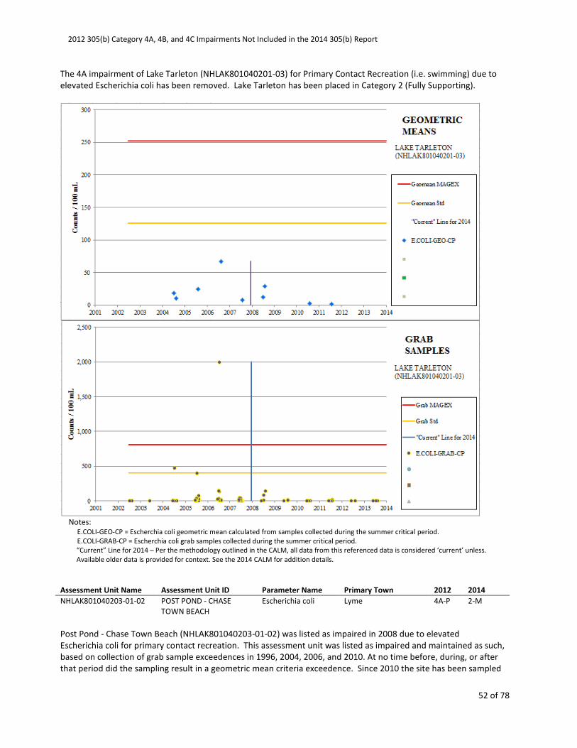
2012 305(b) Category 4A, 4B, and 4C Impairments Not Included in the 2014 305(b) Report
52 of 78
The 4A impairment of Lake Tarleton (NHLAK801040201-03) for Primary Contact Recreation (i.e. swimming) due to
elevated Escherichia coli has been removed. Lake Tarleton has been placed in Category 2 (Fully Supporting).
Notes:
E.COLI-GEO-CP = Escherchia coli geometric mean calculated from samples collected during the summer critical period.
E.COLI-GRAB-CP = Escherchia coli grab samples collected during the summer critical period.
“Current” Line for 2014 – Per the methodology outlined in the CALM, all data from this referenced data is considered ‘current’ unless.
Available older data is provided for context. See the 2014 CALM for addition details.
Assessment Unit Name Assessment Unit ID Parameter Name Primary Town 2012 2014
NHLAK801040203-01-02 POST POND - CHASE
TOWN BEACH
Escherichia coli Lyme 4A-P 2-M
Post Pond - Chase Town Beach (NHLAK801040203-01-02) was listed as impaired in 2008 due to elevated
Escherichia coli for primary contact recreation. This assessment unit was listed as impaired and maintained as such,
based on collection of grab sample exceedences in 1996, 2004, 2006, and 2010. At no time before, during, or after
that period did the sampling result in a geometric mean criteria exceedence. Since 2010 the site has been sampled

2012 305(b) Category 4A, 4B, and 4C Impairments Not Included in the 2014 305(b) Report
53 of 78
every year without any grab sample or geometric mean criteria exceedences. During that time, both the flow and
preceding precipitation conditions experienced during the historic grab sample exceedences have been repeated.
Since the last exceedence in 2010, three years and 19 additional grab samples have been collected which have
been used to calculate three geometric means and no E. coli exceedences have occurred.
The 4A impairment of Post Pond - Chase Town Beach (NHLAK801040203-01-02) for Primary Contact Recreation (i.e.
swimming) due to elevated Escherichia coli has been removed. Post Pond - Chase Town Beach has been placed in
Category 2 (Fully Supporting).
E.COLI-GEO-CP = Escherchia coli geometric mean calculated from samples collected during the summer critical period.
E.COLI-GRAB-CP = Escherchia coli grab samples collected during the summer critical period.
“Current” Line for 2014 – Per the methodology outlined in the CALM, all data from this referenced data is considered ‘current’ unless.
Available older data is provided for context. See the 2014 CALM for addition details.
Assessment Unit Name Assessment Unit ID Parameter Name Primary Town 2012 2014
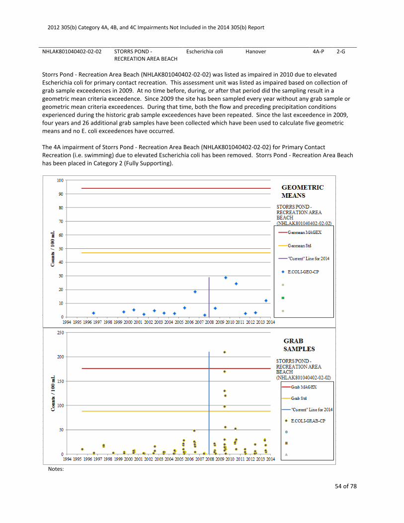
2012 305(b) Category 4A, 4B, and 4C Impairments Not Included in the 2014 305(b) Report
54 of 78
NHLAK801040402-02-02 STORRS POND -
RECREATION AREA BEACH
Escherichia coli Hanover 4A-P 2-G
Storrs Pond - Recreation Area Beach (NHLAK801040402-02-02) was listed as impaired in 2010 due to elevated
Escherichia coli for primary contact recreation. This assessment unit was listed as impaired based on collection of
grab sample exceedences in 2009. At no time before, during, or after that period did the sampling result in a
geometric mean criteria exceedence. Since 2009 the site has been sampled every year without any grab sample or
geometric mean criteria exceedences. During that time, both the flow and preceding precipitation conditions
experienced during the historic grab sample exceedences have been repeated. Since the last exceedence in 2009,
four years and 26 additional grab samples have been collected which have been used to calculate five geometric
means and no E. coli exceedences have occurred.
The 4A impairment of Storrs Pond - Recreation Area Beach (NHLAK801040402-02-02) for Primary Contact
Recreation (i.e. swimming) due to elevated Escherichia coli has been removed. Storrs Pond - Recreation Area Beach
has been placed in Category 2 (Fully Supporting).
Notes:
2012 305(b) Category 4A, 4B, and 4C Impairments Not Included in the 2014 305(b) Report
55 of 78
E.COLI-GEO-CP = Escherchia coli geometric mean calculated from samples collected during the summer critical period.
E.COLI-GRAB-CP = Escherchia coli grab samples collected during the summer critical period.
“Current” Line for 2014 – Per the methodology outlined in the CALM, all data from this referenced data is considered ‘current’ unless.
Available older data is provided for context. See the 2014 CALM for addition details.
Assessment Unit Name Assessment Unit ID Parameter Name Primary Town 2012 2014
NHLAK801040402-02-03 STORRS POND - ADULT
BEACH
Escherichia coli Hanover 4A-M 2-G
Storrs Pond - Adult Beach (NHLAK801040402-02-03) was listed as impaired in 2010 due to elevated Escherichia coli
for primary contact recreation. This assessment unit was listed as impaired based on collection of grab sample
exceedences in 2009. At no time before, during, or after that period did the sampling result in a geometric mean
criteria exceedence. Since 2009 the site has been sampled every year without any grab sample or geometric mean
criteria exceedences. During that time, both the flow and preceding precipitation conditions experienced during
the historic grab sample exceedences have been repeated. Since the last exceedence in 2009, four years and 27
additional grab samples have been collected which have been used to calculate five geometric means and no E. coli
exceedences have occurred.
The 4A impairment of Storrs Pond - Adult Beach (NHLAK801040402-02-03) for Primary Contact Recreation (i.e.
swimming) due to elevated Escherichia coli has been removed. Storrs Pond - Adult Beach has been placed in
Category 2 (Fully Supporting).

2012 305(b) Category 4A, 4B, and 4C Impairments Not Included in the 2014 305(b) Report
56 of 78
Notes:
E.COLI-GEO-CP = Escherchia coli geometric mean calculated from samples collected during the summer critical period.
E.COLI-GRAB-CP = Escherchia coli grab samples collected during the summer critical period.
“Current” Line for 2014 – Per the methodology outlined in the CALM, all data from this referenced data is considered ‘current’ unless.
Available older data is provided for context. See the 2014 CALM for addition details.
Assessment Unit Name Assessment Unit ID Parameter Name Primary Town 2012 2014
NHLAK801060401-08-02 KOLEMOOK LAKE - TOWN
BEACH
Escherichia coli Springfield 4A-P 2-M
Kolemook Lake - Town Beach (NHLAK801060401-08-02) was listed as impaired in 2004 due to elevated Escherichia
coli for primary contact recreation. This assessment unit was listed as impaired and maintained as such based on
collection of grab sample exceedences in 2002 and 2006. At no time before, during, or after that period did the
sampling result in a geometric mean criteria exceedence. Since 2006 the site has been sampled every year without
any grab sample or geometric mean criteria exceedences. During that time, both the flow and preceding
precipitation conditions experienced during the historic grab sample exceedences have been repeated. Since the
last exceedence in 2006, seven years and 51 additional grab samples have been collected which have been used to

2012 305(b) Category 4A, 4B, and 4C Impairments Not Included in the 2014 305(b) Report
57 of 78
calculate 12 geometric means and no E. coli exceedences have occurred.
The 4A impairment of Kolemook Lake - Town Beach (NHLAK801060401-08-02) for Primary Contact Recreation (i.e.
swimming) due to elevated Escherichia coli has been removed. Kolemook Lake - Town Beach has been placed in
Category 2 (Fully Supporting).
Notes:
E.COLI-GEO-CP = Escherchia coli geometric mean calculated from samples collected during the summer critical period.
E.COLI-GRAB-CP = Escherchia coli grab samples collected during the summer critical period.
“Current” Line for 2014 – Per the methodology outlined in the CALM, all data from this referenced data is considered ‘current’ unless.
Available older data is provided for context. See the 2014 CALM for addition details.
Assessment Unit Name Assessment Unit ID Parameter Name Primary Town 2012 2014
NHLAK801060402-04-02 LITTLE SUNAPEE LAKE -
BUCKLIN TOWN BEACH
Escherichia coli New London 4A-M 2-G
Little Sunapee Lake - Bucklin Town Beach (NHLAK801060402-04-02) was listed as impaired in 2008 due to elevated
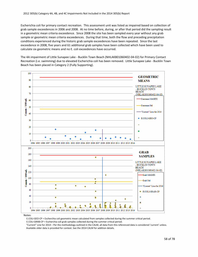
2012 305(b) Category 4A, 4B, and 4C Impairments Not Included in the 2014 305(b) Report
58 of 78
Escherichia coli for primary contact recreation. This assessment unit was listed as impaired based on collection of
grab sample exceedences in 2006 and 2008. At no time before, during, or after that period did the sampling result
in a geometric mean criteria exceedence. Since 2008 the site has been sampled every year without any grab
sample or geometric mean criteria exceedences. During that time, both the flow and preceding precipitation
conditions experienced during the historic grab sample exceedences have been repeated. Since the last
exceedence in 2008, five years and 61 additional grab samples have been collected which have been used to
calculate six geometric means and no E. coli exceedences have occurred.
The 4A impairment of Little Sunapee Lake - Bucklin Town Beach (NHLAK801060402-04-02) for Primary Contact
Recreation (i.e. swimming) due to elevated Escherichia coli has been removed. Little Sunapee Lake - Bucklin Town
Beach has been placed in Category 2 (Fully Supporting).
Notes:
E.COLI-GEO-CP = Escherchia coli geometric mean calculated from samples collected during the summer critical period.
E.COLI-GRAB-CP = Escherchia coli grab samples collected during the summer critical period.
“Current” Line for 2014 – Per the methodology outlined in the CALM, all data from this referenced data is considered ‘current’ unless.
Available older data is provided for context. See the 2014 CALM for addition details.
2012 305(b) Category 4A, 4B, and 4C Impairments Not Included in the 2014 305(b) Report
59 of 78
Assessment Unit Name Assessment Unit ID Parameter Name Primary Town 2012 2014
NHLAK801060402-12-02 OTTER POND - MORGAN
BEACH
Escherichia coli New London 4A-P 2-G
Otter Pond - Morgan Beach (NHLAK801060402-12-02) was listed as impaired in 2002 due to elevated Escherichia
coli for primary contact recreation. This assessment unit was listed as impaired and maintained as such based on
the collection of grab sample exceedences in 2000 and 2006. At no time before, during, or after that period did the
sampling result in a geometric mean criteria exceedence. Since 2006 the site has been sampled every year without
any grab sample or geometric mean criteria exceedences. During that time, both the flow and preceding
precipitation conditions experienced during the historic grab sample exceedences have been repeated. Since the
last exceedence in 2006, seven years and 51 additional grab samples have been collected which have been used to
calculate sixteen geometric means and no E. coli exceedences have occurred.
The 4A impairment of Otter Pond - Morgan Beach (NHLAK801060402-12-02) for Primary Contact Recreation (i.e.
swimming) due to elevated Escherichia coli has been removed. Otter Pond - Morgan Beach has been placed in
Category 2 (Fully Supporting).

2012 305(b) Category 4A, 4B, and 4C Impairments Not Included in the 2014 305(b) Report
60 of 78
Notes:
E.COLI-GEO-CP = Escherchia coli geometric mean calculated from samples collected during the summer critical period.
E.COLI-GEO-NCP = Escherchia coli geometric mean calculated from samples collected outside the summer critical period.
E.COLI-GRAB-CP = Escherchia coli grab samples collected during the summer critical period.
E.COLI-GRAB-NCP = Escherchia coli grab samples collected outside the summer critical period.
“Current” Line for 2014 – Per the methodology outlined in the CALM, all data from this referenced data is considered ‘current’ unless.
Available older data is provided for context. See the 2014 CALM for addition details.
Assessment Unit Name Assessment Unit ID Parameter Name Primary Town 2012 2014
NHLAK801060403-04-02 RAND POND - PUBLIC WAY
BEACH
Escherichia coli Goshen 4A-P 2-G
Rand Pond - Public Way Beach (NHLAK801060403-04-02) was listed as impaired in 2008 due to elevated Escherichia
coli for primary contact recreation. This assessment unit was listed as impaired based on collection of grab sample
exceedences in 2006. At no time before, during, or after that period did the sampling result in a geometric mean
criteria exceedence. Since 2006 the site has been sampled every year without any grab sample or geometric mean
criteria exceedences. During that time, both the flow and preceding precipitation conditions experienced during the

2012 305(b) Category 4A, 4B, and 4C Impairments Not Included in the 2014 305(b) Report
61 of 78
historic grab sample exceedences have been repeated. Since the last exceedence in 2006, seven years and 48
additional grab samples have been collected which have been used to calculate eight geometric means and no E.
coli exceedences have occurred.
The 4A impairment of Rand Pond - Public Way Beach (NHLAK801060403-04-02) for Primary Contact Recreation (i.e.
swimming) due to elevated Escherichia coli has been removed. Rand Pond - Public Way Beach has been placed in
Category 2 (Fully Supporting).
Notes:
E.COLI-GEO-CP = Escherchia coli geometric mean calculated from samples collected during the summer critical period.
E.COLI-GRAB-CP = Escherchia coli grab samples collected during the summer critical period.
“Current” Line for 2014 – Per the methodology outlined in the CALM, all data from this referenced data is considered ‘current’ unless.
Available older data is provided for context. See the 2014 CALM for addition details.
Assessment Unit Name Assessment Unit ID Parameter Name Primary Town 2012 2014
NHLAK802010101-06-02 MILLEN POND - TOWN
BEACH
Escherichia coli Washington 4A-P 2-M

2012 305(b) Category 4A, 4B, and 4C Impairments Not Included in the 2014 305(b) Report
62 of 78
Millen Pond - Town Beach (NHLAK802010101-06-02) was listed as impaired in 2008 due to elevated Escherichia coli
for primary contact recreation. This assessment unit was listed as impaired and maintained as such based on
collection of grab sample exceedences in 1999, 2007, and 2010. At no time before, during, or after that period did
the sampling result in a geometric mean criteria exceedence. Since 2010 the site has been sampled every year
without any grab sample or geometric mean criteria exceedences. During that time, both the flow and preceding
precipitation conditions experienced during the historic grab sample exceedences have been repeated. Since the
last exceedence in 2010, three years and 30 additional grab samples have been collected which have been used to
calculate four geometric means and no E. coli exceedences have occurred.
The 4A impairment of Millen Pond - Town Beach (NHLAK802010101-06-02) for Primary Contact Recreation (i.e.
swimming) due to elevated Escherichia coli has been removed. Millen Pond - Town Beach has been placed in
Category 2 (Fully Supporting).
Notes:
E.COLI-GEO-CP = Escherchia coli geometric mean calculated from samples collected during the summer critical period.
E.COLI-GRAB-CP = Escherchia coli grab samples collected during the summer critical period.
2012 305(b) Category 4A, 4B, and 4C Impairments Not Included in the 2014 305(b) Report
63 of 78
“Current” Line for 2014 – Per the methodology outlined in the CALM, all data from this referenced data is considered ‘current’ unless.
Available older data is provided for context. See the 2014 CALM for addition details.
Assessment Unit Name Assessment Unit ID Parameter Name Primary Town 2012 2014
NHLAK802020202-02-02 LAUREL LAKE - TOWN
BEACH
Escherichia coli Fitzwilliam 4A-P 2-G
Laurel Lake - Town Beach (NHLAK802020202-02-02) was listed as impaired in 2010 due to elevated Escherichia coli
for primary contact recreation. This assessment unit was listed as impaired based on collection of grab sample
exceedences in 2002 and 2009. At no time before, during, or after that period did the sampling result in a
geometric mean criteria exceedence. Since 2009 the site has been sampled every year without any grab sample or
geometric mean criteria exceedences. During that time, both the flow and preceding precipitation conditions
experienced during the historic grab sample exceedences have been repeated. Since the last exceedence in 2009,
four years and 35 additional grab samples have been collected which have been used to calculate eight geometric
means and no E. coli exceedences have occurred.
The 4A impairment of Laurel Lake - Town Beach (NHLAK802020202-02-02) for Primary Contact Recreation (i.e.
swimming) due to elevated Escherichia coli has been removed. Laurel Lake - Town Beach has been placed in
Category 2 (Fully Supporting).
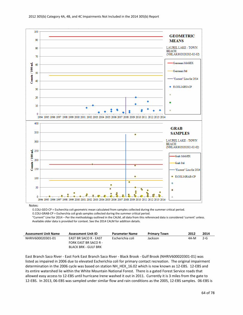
2012 305(b) Category 4A, 4B, and 4C Impairments Not Included in the 2014 305(b) Report
64 of 78
Notes:
E.COLI-GEO-CP = Escherchia coli geometric mean calculated from samples collected during the summer critical period.
E.COLI-GRAB-CP = Escherchia coli grab samples collected during the summer critical period.
“Current” Line for 2014 – Per the methodology outlined in the CALM, all data from this referenced data is considered ‘current’ unless.
Available older data is provided for context. See the 2014 CALM for addition details.
Assessment Unit Name Assessment Unit ID Parameter Name Primary Town 2012 2014
NHRIV600020301-01 EAST BR SACO R - EAST
FORK EAST BR SACO R -
BLACK BRK - GULF BRK
Escherichia coli Jackson 4A-M 2-G
East Branch Saco River - East Fork East Branch Saco River - Black Brook - Gulf Brook (NHRIV600020301-01) was
listed as impaired in 2006 due to elevated Escherichia coli for primary contact recreation. The original impairment
determination in the 2006 cycle was based on station NH_HEX_16.02 which is now known as 12-EBS. 12-EBS and
its entire watershed lie within the White Mountain National Forest. There is a gated Forest Service roads that
allowed easy access to 12-EBS until hurricane Irene washed it out in 2011. Currently it is 3 miles from the gate to
12-EBS. In 2013, 06-EBS was sampled under similar flow and rain conditions as the 2005, 12-EBS samples. 06-EBS is
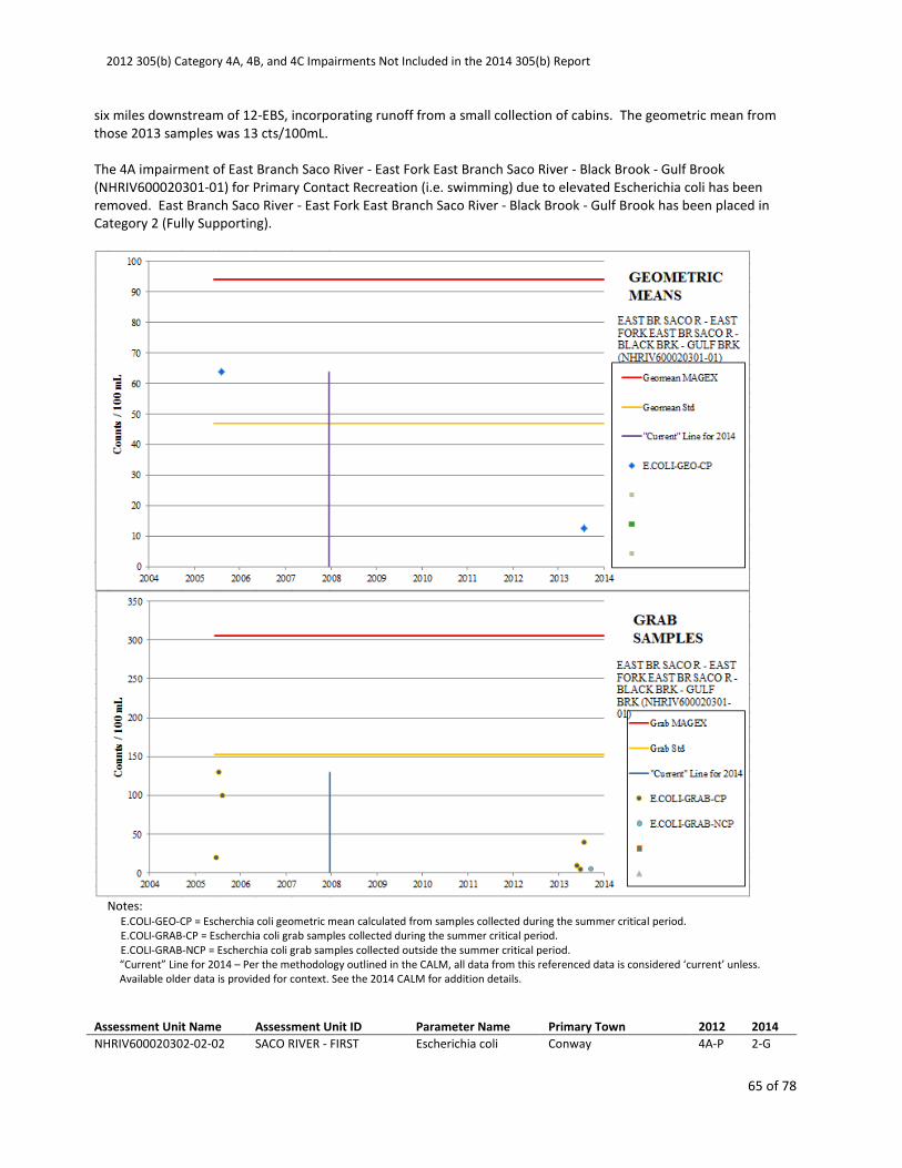
2012 305(b) Category 4A, 4B, and 4C Impairments Not Included in the 2014 305(b) Report
65 of 78
six miles downstream of 12-EBS, incorporating runoff from a small collection of cabins. The geometric mean from
those 2013 samples was 13 cts/100mL.
The 4A impairment of East Branch Saco River - East Fork East Branch Saco River - Black Brook - Gulf Brook
(NHRIV600020301-01) for Primary Contact Recreation (i.e. swimming) due to elevated Escherichia coli has been
removed. East Branch Saco River - East Fork East Branch Saco River - Black Brook - Gulf Brook has been placed in
Category 2 (Fully Supporting).
Notes:
E.COLI-GEO-CP = Escherchia coli geometric mean calculated from samples collected during the summer critical period.
E.COLI-GRAB-CP = Escherchia coli grab samples collected during the summer critical period.
E.COLI-GRAB-NCP = Escherchia coli grab samples collected outside the summer critical period.
“Current” Line for 2014 – Per the methodology outlined in the CALM, all data from this referenced data is considered ‘current’ unless.
Available older data is provided for context. See the 2014 CALM for addition details.
Assessment Unit Name Assessment Unit ID Parameter Name Primary Town 2012 2014
NHRIV600020302-02-02 SACO RIVER - FIRST Escherichia coli Conway 4A-P 2-G
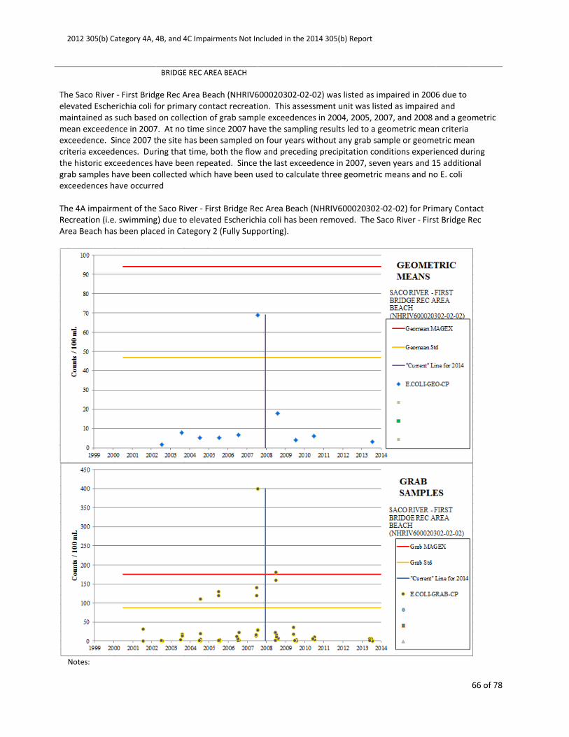
2012 305(b) Category 4A, 4B, and 4C Impairments Not Included in the 2014 305(b) Report
66 of 78
BRIDGE REC AREA BEACH
The Saco River - First Bridge Rec Area Beach (NHRIV600020302-02-02) was listed as impaired in 2006 due to
elevated Escherichia coli for primary contact recreation. This assessment unit was listed as impaired and
maintained as such based on collection of grab sample exceedences in 2004, 2005, 2007, and 2008 and a geometric
mean exceedence in 2007. At no time since 2007 have the sampling results led to a geometric mean criteria
exceedence. Since 2007 the site has been sampled on four years without any grab sample or geometric mean
criteria exceedences. During that time, both the flow and preceding precipitation conditions experienced during
the historic exceedences have been repeated. Since the last exceedence in 2007, seven years and 15 additional
grab samples have been collected which have been used to calculate three geometric means and no E. coli
exceedences have occurred
The 4A impairment of the Saco River - First Bridge Rec Area Beach (NHRIV600020302-02-02) for Primary Contact
Recreation (i.e. swimming) due to elevated Escherichia coli has been removed. The Saco River - First Bridge Rec
Area Beach has been placed in Category 2 (Fully Supporting).
Notes:
2012 305(b) Category 4A, 4B, and 4C Impairments Not Included in the 2014 305(b) Report
67 of 78
E.COLI-GEO-CP = Escherchia coli geometric mean calculated from samples collected during the summer critical period.
E.COLI-GRAB-CP = Escherchia coli grab samples collected during the summer critical period.
“Current” Line for 2014 – Per the methodology outlined in the CALM, all data from this referenced data is considered ‘current’ unless.
Available older data is provided for context. See the 2014 CALM for addition details.
Assessment Unit Name Assessment Unit ID Parameter Name Primary Town 2012 2014
NHRIV600020304-01-02 SACO RIVER - DAVIS PARK
REC AREA BEACH
Escherichia coli Conway 4A-P 2-G
The Saco River - Davis Park Rec Area Beach (NHRIV600020304-01-02) was listed as impaired in 2008 due to
elevated Escherichia coli for primary contact recreation. This assessment unit was listed as impaired based on
collection of grab sample exceedences in 2001, 2007, and 2008. At no time before, during, or after that period did
the sampling result in a geometric mean criteria exceedence. Since 2008 the site has been sampled every year
without any grab sample or geometric mean criteria exceedences. During that time, both the flow and preceding
precipitation conditions experienced during the historic grab sample exceedences have been repeated. Since the
last exceedence in 2008, five years and 32 additional grab samples have been collected which have been used to
calculate six geometric means and no E. coli exceedences have occurred.
The 4A impairment of the Saco River - Davis Park Rec Area Beach (NHRIV600020304-01-02) for Primary Contact
Recreation (i.e. swimming) due to elevated Escherichia coli has been removed. The Saco River - Davis Park Rec Area
Beach has been placed in Category 2 (Fully Supporting).
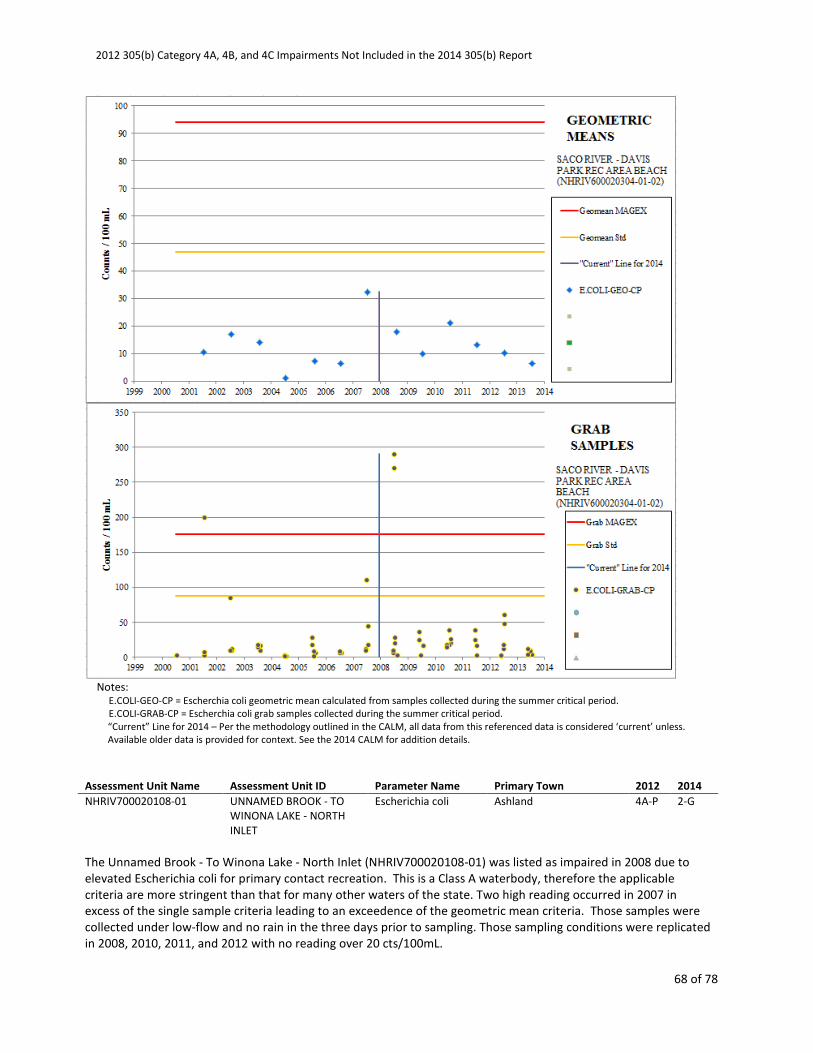
2012 305(b) Category 4A, 4B, and 4C Impairments Not Included in the 2014 305(b) Report
68 of 78
Notes:
E.COLI-GEO-CP = Escherchia coli geometric mean calculated from samples collected during the summer critical period.
E.COLI-GRAB-CP = Escherchia coli grab samples collected during the summer critical period.
“Current” Line for 2014 – Per the methodology outlined in the CALM, all data from this referenced data is considered ‘current’ unless.
Available older data is provided for context. See the 2014 CALM for addition details.
Assessment Unit Name Assessment Unit ID Parameter Name Primary Town 2012 2014
NHRIV700020108-01 UNNAMED BROOK - TO
WINONA LAKE - NORTH
INLET
Escherichia coli Ashland 4A-P 2-G
The Unnamed Brook - To Winona Lake - North Inlet (NHRIV700020108-01) was listed as impaired in 2008 due to
elevated Escherichia coli for primary contact recreation. This is a Class A waterbody, therefore the applicable
criteria are more stringent than that for many other waters of the state. Two high reading occurred in 2007 in
excess of the single sample criteria leading to an exceedence of the geometric mean criteria. Those samples were
collected under low-flow and no rain in the three days prior to sampling. Those sampling conditions were replicated
in 2008, 2010, 2011, and 2012 with no reading over 20 cts/100mL.

2012 305(b) Category 4A, 4B, and 4C Impairments Not Included in the 2014 305(b) Report
69 of 78
The 4A impairment of the Unnamed Brook - To Winona Lake - North Inlet (NHRIV700020108-01) for Primary
Contact Recreation (i.e. swimming) due to elevated Escherichia coli has been removed. The Unnamed Brook - To
Winona Lake - North Inlet has been placed in Category 2 (Fully Supporting).
Notes:
E.COLI-GEO-CP = Escherchia coli geometric mean calculated from samples collected during the summer critical period.
E.COLI-GRAB-CP = Escherchia coli grab samples collected during the summer critical period.
E.COLI-GRAB-NCP = Escherchia coli grab samples collected outside the summer critical period.
“Current” Line for 2014 – Per the methodology outlined in the CALM, all data from this referenced data is considered ‘current’ unless.
Available older data is provided for context. See the 2014 CALM for addition details.
Assessment Unit Name Assessment Unit ID Parameter Name Primary Town 2012 2014
NHRIV700030101-05 TOWNLINE INLET TO
CONTOOCOOK LAKE
Escherichia coli Jaffrey 4A-P 2-G
Townline Inlet To Contoocook Lake (NHRIV700030101-05) was listed as impaired in 2002 due to elevated
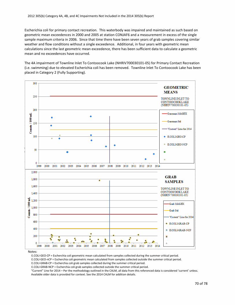
2012 305(b) Category 4A, 4B, and 4C Impairments Not Included in the 2014 305(b) Report
70 of 78
Escherichia coli for primary contact recreation. This waterbody was impaired and maintained as such based on
geometric mean exceedences in 2000 and 2005 at station CONJAF6 and a measurement in excess of the single
sample maximum criteria in 2006. Since that time there have been seven years of grab samples covering similar
weather and flow conditions without a single exceedence. Additional, in four years with geometric mean
calculations since the last geometric mean exceedence, there has been sufficient data to calculate a geometric
mean and no exceedences have occurred.
The 4A impairment of Townline Inlet To Contoocook Lake (NHRIV700030101-05) for Primary Contact Recreation
(i.e. swimming) due to elevated Escherichia coli has been removed. Townline Inlet To Contoocook Lake has been
placed in Category 2 (Fully Supporting).
Notes:
E.COLI-GEO-CP = Escherchia coli geometric mean calculated from samples collected during the summer critical period.
E.COLI-GEO-nCP = Escherchia coli geometric mean calculated from samples collected outside the summer critical period.
E.COLI-GRAB-CP = Escherchia coli grab samples collected during the summer critical period.
E.COLI-GRAB-NCP = Escherchia coli grab samples collected outside the summer critical period.
“Current” Line for 2014 – Per the methodology outlined in the CALM, all data from this referenced data is considered ‘current’ unless.
Available older data is provided for context. See the 2014 CALM for addition details.

2012 305(b) Category 4A, 4B, and 4C Impairments Not Included in the 2014 305(b) Report
71 of 78
Assessment Unit Name Assessment Unit ID Parameter Name Primary Town 2012 2014
NHRIV700030107-07 MOOSE BROOK -
UNNAMED BROOK
Escherichia coli Hancock 4A-M 2-G
Moose Brook - Unnamed Brook (NHRIV700030107-07) was listed as impaired in 2008 due to elevated Escherichia
coli for primary contact recreation. This waterbody appears to have been impaired based on a single high reading
in 2006 and should not have been added to the impaired water waterbodies list. Since that high reading, 13 grab
samples have been collected covering similar flow and weather conditions of the high value from 2006 with no
confirmation exceedence. Additionally, sufficient samples were collected in 2008 to calculate two geometric
means which were 25.2 and 32.8 cts/100 mL, well below the 126 cts/100 mL geometric mean criteria.
The 4A impairment of Moose Brook - Unnamed Brook (NHRIV700030107-07) for Primary Contact Recreation (i.e.
swimming) due to elevated Escherichia coli has been removed. Moose Brook - Unnamed Brook has been placed in
Category 2 (Fully Supporting).

2012 305(b) Category 4A, 4B, and 4C Impairments Not Included in the 2014 305(b) Report
72 of 78
Notes:
E.COLI-GEO-CP = Escherchia coli geometric mean calculated from samples collected during the summer critical period.
E.COLI-GEO-NCP = Escherchia coli geometric mean calculated from samples collected outside the summer critical period.
E.COLI-GRAB-CP = Escherchia coli grab samples collected during the summer critical period.
E.COLI-GRAB-NCP = Escherchia coli grab samples collected outside the summer critical period.
“Current” Line for 2014 – Per the methodology outlined in the CALM, all data from this referenced data is considered ‘current’ unless.
Available older data is provided for context. See the 2014 CALM for addition details.
Assessment Unit Name Assessment Unit ID Parameter Name Primary Town 2012 2014
NHRIV700030204-04 BEARD BROOK -
UNNAMED BROOK
Escherichia coli Washington 4A-M 2-M
Beard Brook - Unnamed Brook (NHRIV700030204-04) was listed as impaired in 2006 due to elevated Escherichia
coli for primary contact recreation. Most of the data for this waterbody comes from station ISLWASB including the
earlier minor exceedences of the single sample maximum criteria. Since the last single sample exceedence in early
2008, there have been five full years of sampling covering the conditions of the original exceedences without any
additional values over the single sample maximum criteria. Back in 2004 there were two slight exceedences of the
geometric mean criteria, an E. coli level which has not since been repeated.
The 4A impairment of Beard Brook - Unnamed Brook (NHRIV700030204-04) for Primary Contact Recreation (i.e.
swimming) due to elevated Escherichia coli has been removed. Beard Brook - Unnamed Brook has been placed in
Category 2 (Fully Supporting).
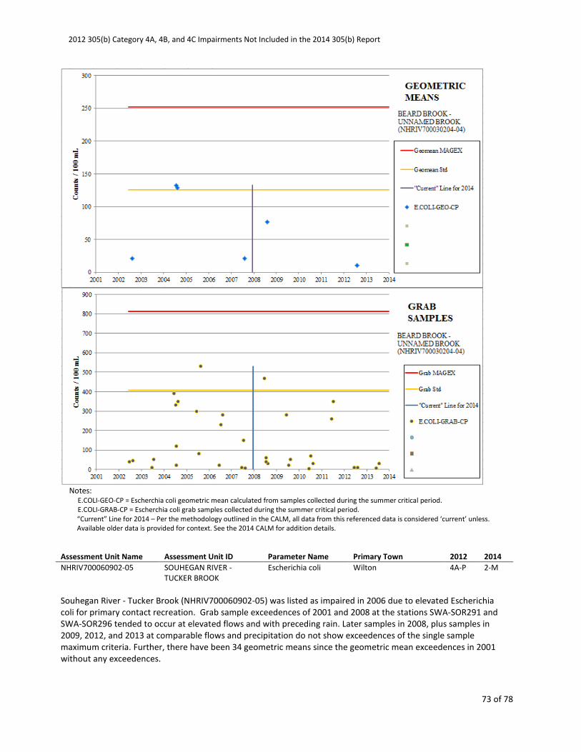
2012 305(b) Category 4A, 4B, and 4C Impairments Not Included in the 2014 305(b) Report
73 of 78
Notes:
E.COLI-GEO-CP = Escherchia coli geometric mean calculated from samples collected during the summer critical period.
E.COLI-GRAB-CP = Escherchia coli grab samples collected during the summer critical period.
“Current” Line for 2014 – Per the methodology outlined in the CALM, all data from this referenced data is considered ‘current’ unless.
Available older data is provided for context. See the 2014 CALM for addition details.
Assessment Unit Name Assessment Unit ID Parameter Name Primary Town 2012 2014
NHRIV700060902-05 SOUHEGAN RIVER -
TUCKER BROOK
Escherichia coli Wilton 4A-P 2-M
Souhegan River - Tucker Brook (NHRIV700060902-05) was listed as impaired in 2006 due to elevated Escherichia
coli for primary contact recreation. Grab sample exceedences of 2001 and 2008 at the stations SWA-SOR291 and
SWA-SOR296 tended to occur at elevated flows and with preceding rain. Later samples in 2008, plus samples in
2009, 2012, and 2013 at comparable flows and precipitation do not show exceedences of the single sample
maximum criteria. Further, there have been 34 geometric means since the geometric mean exceedences in 2001
without any exceedences.
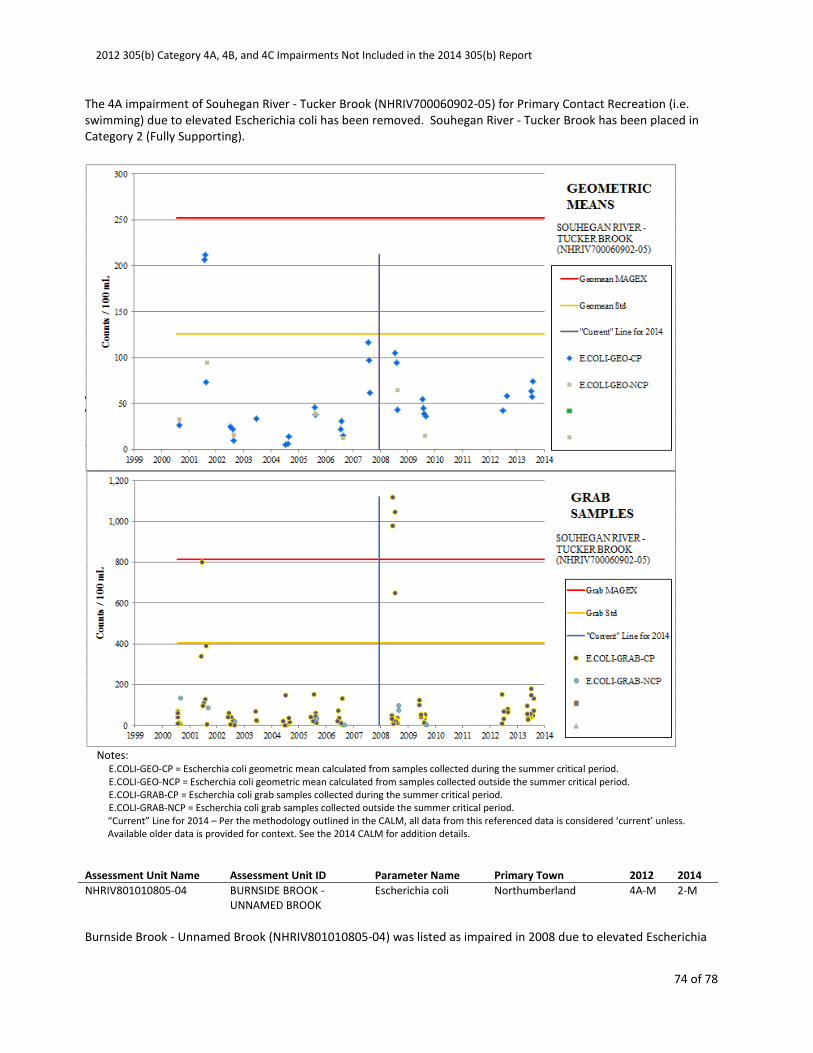
2012 305(b) Category 4A, 4B, and 4C Impairments Not Included in the 2014 305(b) Report
74 of 78
The 4A impairment of Souhegan River - Tucker Brook (NHRIV700060902-05) for Primary Contact Recreation (i.e.
swimming) due to elevated Escherichia coli has been removed. Souhegan River - Tucker Brook has been placed in
Category 2 (Fully Supporting).
Notes:
E.COLI-GEO-CP = Escherchia coli geometric mean calculated from samples collected during the summer critical period.
E.COLI-GEO-NCP = Escherchia coli geometric mean calculated from samples collected outside the summer critical period.
E.COLI-GRAB-CP = Escherchia coli grab samples collected during the summer critical period.
E.COLI-GRAB-NCP = Escherchia coli grab samples collected outside the summer critical period.
“Current” Line for 2014 – Per the methodology outlined in the CALM, all data from this referenced data is considered ‘current’ unless.
Available older data is provided for context. See the 2014 CALM for addition details.
Assessment Unit Name Assessment Unit ID Parameter Name Primary Town 2012 2014
NHRIV801010805-04 BURNSIDE BROOK -
UNNAMED BROOK
Escherichia coli Northumberland 4A-M 2-M
Burnside Brook - Unnamed Brook (NHRIV801010805-04) was listed as impaired in 2008 due to elevated Escherichia

2012 305(b) Category 4A, 4B, and 4C Impairments Not Included in the 2014 305(b) Report
75 of 78
coli for primary contact recreation. All samples have been collected at 03-OTT. Although the upstream watershed
is very rural, it is heavily agricultural in the valley bottom. This watershed has the benefits of a very active
volunteer monitoring group that have made on the ground efforts to talk with the farmers and help make
improvements. There have been ample samples collected in 2001, 2011, 2012, and 2013 to illustrate that water
quality criteria are being met at both low and high flow conditions with both little rain and storms in the three days
prior to sampling. Although the more recent data does not cover the time when the indicator stream gage reached
10 cfsm, that flow has only been exceeded four percent of the time since 1990 and even more rarely (2.5 percent of
the time) during the summer season when dairy cattle are likely to be out in the pastures.
The 4A impairment of Burnside Brook - Unnamed Brook (NHRIV801010805-04) for Primary Contact Recreation (i.e.
swimming) due to elevated Escherichia coli has been removed. Burnside Brook - Unnamed Brook has been placed
in Category 2 (Fully Supporting).
Notes:
E.COLI-GEO-CP = Escherchia coli geometric mean calculated from samples collected during the summer critical period.
E.COLI-GRAB-CP = Escherchia coli grab samples collected during the summer critical period.
“Current” Line for 2014 – Per the methodology outlined in the CALM, all data from this referenced data is considered ‘current’ unless.
Available older data is provided for context. See the 2014 CALM for addition details.
2012 305(b) Category 4A, 4B, and 4C Impairments Not Included in the 2014 305(b) Report
76 of 78
GROUP 8. Non-Native Aquatic Plants
Exotic macrophytes are non-native, fast growing aquatic plants, which can quickly
dominate and choke out native aquatic plant growth in the surface water. Examples of exotic
macrophytes include variable milfoil (Myriophyllum heterophyllum), Eurasian milfoil
(Myriophyllum spicatum), fanwort (Cabomba caroliniana) and water chestnut (Trapa natans).
Such infestations are in violation of Env-Wq 1703.19, which states that surface waters shall
support and maintain a balanced, integrated and adaptive community of organisms having a
species composition, diversity, and functional organization comparable to that of similar natural
habitats of a region.
Assessment Category 4C is represents cases where a waterbody is impaired or
threatened for one or more designated uses but does not require the development of a TMDL
because the impairment is not caused by a pollutant.
Assessment Unit Name Assessment Unit ID Parameter Name Primary Town 2012 2014
NHLAK700060402-10-01 LOWER SUNCOOK POND Non-Native Aquatic
Plants
Barnstead 4C-M 3-PNS
Lower Suncook Pond (NHLAK700060402-10-01) was listed as impaired in 2006 for non-native aquatic plants for the
aquatic life designated use. Infestation by Variable milfoil is currently at a low density/coverage. As of April 2014
control actions include; Herbicide treatment and hand removal and suction harvesting. Reduced growth observed
to a level that this in no longer considered and infestation.
The 4C impairment of Lower Suncook Pond (NHLAK700060402-10-01) for the aquatic life designated use due to
non-native aquatic plants has been removed. Lower Suncook Pond has been placed in Category 3 (Insufficient
Information).
Assessment Unit Name Assessment Unit ID Parameter Name Primary Town 2012 2014
NHLAK700060502-08-02 NORTHWOOD LAKE -
TOWN BEACH
Non-Native Aquatic
Plants
Northwood 4C-M 3-PNS
Northwood Lake - Town Beach (NHLAK700060502-08-02) was listed as impaired in 2006 for non-native aquatic
plants for the aquatic life designated use. Infestation by Variable milfoil is a possible issue however, as of April
2014 ongoing treatment has maintained the variable milfoil outside of the beach area.
The 4C impairment of Northwood Lake - Town Beach (NHLAK700060502-08-02) for the aquatic life designated use
due to non-native aquatic plants has been removed. Northwood Lake - Town Beach has been placed in Category 3
(Insufficient Information).
Assessment Unit Name Assessment Unit ID Parameter Name Primary Town 2012 2014
NHLAK802010401-01-02 FOREST LAKE - TOWN
BEACH
Non-Native Aquatic
Plants
Winchester 4C-M 3-PNS
Forest Lake - Town Beach (NHLAK802010401-01-02) was listed as impaired in 2006 for non-native aquatic plants for
the aquatic life designated use. Infestation by Variable milfoil is a possible issue however, as of April 2014 ongoing
treatment has maintained the variable milfoil outside of the beach area.
2012 305(b) Category 4A, 4B, and 4C Impairments Not Included in the 2014 305(b) Report
77 of 78
The 4C impairment of Forest Lake - Town Beach (NHLAK802010401-01-02) for the aquatic life designated use due
to non-native aquatic plants has been removed. Forest Lake - Town Beach has been placed in Category 3
(Insufficient Information).
GROUP 9. Habitat Assessments (Streams)
The maintenance of a balanced, integrated, and adaptive community described in Env-
Wq 1703.19 will be limited if the suitable habitat for that natural community has been severely
degraded. The requirement to restore surface waters for designated uses and maintain the
physical integrity of surface waters is described in Env-Wq 1703.01(b) and Env-Wq 1703.03(c).
Assessment Category 4C is represents cases where a waterbody is impaired or
threatened for one or more designated uses but does not require the development of a TMDL
because the impairment is not caused by a pollutant,
Assessment Unit Name Assessment Unit ID Parameter Name Primary Town 2012 2014
NHRIV700060201-04 ACADEMY BROOK - LOON
POND BROOK
Habitat Assessment
(Streams)
Gilmanton 4C-M 3-ND
Academy Brook - Loon Pond Brook (NHRIV700060201-04) was listed as impaired in 2006 for habitat assessment
(streams) for the aquatic life designated use. The two stations used to impair Academy Brook - Loon Pond Brook
(NHRIV700060201-04) were associated to the wrong AUID. Station SP04M-102 should have been associated to
AUID NHRIV700060201-09 which is already associated with samples at SP04M-100 and SP04M-101. Station
SP04M-104 should have been associated to AUID NHRIV700060201-10 which is already listed as impaired based on
other samples at SP04M-103, SP04M-104, and SP04M-105.
The 4C impairment of Academy Brook - Loon Pond Brook (NHRIV700060201-04) for the aquatic life designated use
due to habitat assessment (streams) has been removed. Academy Brook - Loon Pond Brook has been placed in
Category 3 (No Data).
GROUP 10. Dissolved Oxygen (DO)
Dissolved oxygen is critical to the balanced, integrative, and adaptive community of
organisms as described in Env-Wq 1703.19. As such, the water quality standard provide criteria
for Class A waters, Class B waters, waters with cold water fish species, and in both thermally
stratified and unstratified lakes, impoundments, and reservoirs in Env-Wq 1703.07 (a), (b), (c),
and (d).
Assessment category 4A is reserved for cases where a waterbody is impaired or
threatened for one or more designated uses but does not require the development of a TMDL
because a TMDL has been completed
Assessment Unit Name Assessment Unit ID Parameter Name Primary Town 2012 2014
NHRIV600030709-01 LAMPREY RIVER Oxygen, Dissolved Epping 4A-M 3-ND
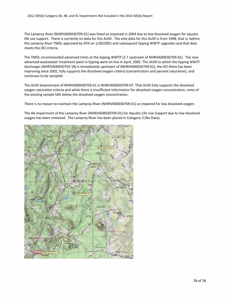
2012 305(b) Category 4A, 4B, and 4C Impairments Not Included in the 2014 305(b) Report
78 of 78
The Lamprey River (NHRIV600030709-01) was listed as impaired in 2004 due to low dissolved oxygen for aquatic
life use support. There is currently no data for this AUID. The only data for this AUID is from 1998, that is, before
the Lamprey River TMDL approved by EPA on 1/30/2001 and subsequent Epping WWTF upgrades and that data
meets the DO criteria.
The TMDL recommended advanced limits at the Epping WWTP (2.7 upstream of NHRIV600030709-01). The new
advanced wastewater treatment plant in Epping went on line in April, 2002. The AUID to which the Epping WWTF
discharges (NHRIV600030703-18) is immediately upstream of (NHRIV600030709-01), the DO there has been
improving since 2002, fully supports the dissolved oxygen criteria (concentration and percent saturation), and
continues to be sampled.
The AUID downstream of NHRIV600030709-01 is NHRIV600030709-07. That AUID fully supports the dissolved
oxygen saturation criteria and while there is insufficient information for dissolved oxygen concentration, none of
the existing sample falls below the dissolved oxygen concentration.
There is no reason to maintain the Lamprey River (NHRIV600030709-01) as impaired for low dissolved oxygen.
The 4A impairment of the Lamprey River (NHRIV600030709-01) for Aquatic Life Use Support due to low dissolved
oxygen has been removed. The Lamprey River has been placed in Category 3 (No Data).


