1 2013 Fire Season Weather Summary Summary The first week of June, the 2013 Fire Season looked like it would be an extremely busy one. But despite many temperature and precipitation comparisons to the record-breaking 2004 fire season, a lack of lightning kept the number of acres burned to a near average 1.3 million acres. The most significant fire of the year, the Stuart Creek Fire, threatened parts of Fairbanks for several weeks and demanded a great amount of resources due to the extremely dry fuel conditions and proximity to residential areas in the wild land interface. In all, there were three fuels advisories issued over the course of the summer, for extreme fire behavior potential due to these dry conditions. An extremely cold spring and some of the latest snowfalls on record settled everyone into thinking that fire season would never really arrive. Snowmelt dates were some of the latest ever observed. After Fairbanks set cold temperature records on May 20 th , summer finally arrived, and Fairbanks reported record highs just ten days later. These hot temperatures set the pace for the summer, with several stations around the state breaking all-time high temperature records in June, July, and August. Anchorage had the most consecutive days over 70, while Fairbanks surpassed the 80 degree mark on 36 days, blasting the 2004 record of 30 days. There was little precipitation for most of the state, with South Central finally catching a reprieve by the second week of August. By the end of August, low temperature records were again being set across Interior Alaska, and one of the earlier snowfalls on record for Fairbanks made it the 4 th shortest summer (summer defined as having no snow on the ground). Nearly statewide, one of the shortest summers had also been one of the hottest and driest! The dry, stable air mass that accompanied these hot temperatures prevented Alaska from having a potentially catastrophic fire season, as was observed in the similarly hot summer of 2004. The dry air and stability limited thunderstorm activity, with far fewer lightning strikes. This meant fewer remote starts, which are typically the culprits of large burned acreage in Alaska. The potential for lightning to rapidly ramp up the fire season was evidenced in Southwest Alaska, where numerous lightning fires started on just a couple of busy lightning days. Most starts for the rest of the season were human-caused and in populated areas where rapid initial attack resulted in fewer acres burned.
Transcript
1
2013 Fire Season Weather Summary
Summary
The first week of June, the 2013 Fire Season looked like it would be an extremely busy one. But despite many temperature and precipitation comparisons to the record-breaking 2004 fire season, a lack of lightning kept the number of acres burned to a near average 1.3 million acres. The most significant fire of the year, the Stuart Creek Fire, threatened parts of Fairbanks for several weeks and demanded a great amount of resources due to the extremely dry fuel conditions and proximity to residential areas in the wild land interface. In all, there were three fuels advisories issued over the course of the summer, for extreme fire behavior potential due to these dry conditions.
An extremely cold spring and some of the latest snowfalls on record settled everyone into thinking that fire season would never really arrive. Snowmelt dates were some of the latest ever observed. After Fairbanks set cold temperature records on May 20th, summer finally arrived, and Fairbanks reported record highs just ten days later. These hot temperatures set the pace for the summer, with several stations around the state breaking all-time high temperature records in June, July, and August. Anchorage had the most consecutive days over 70, while Fairbanks surpassed the 80 degree mark on 36 days, blasting the 2004 record of 30 days. There was little precipitation for most of the state, with South Central finally catching a reprieve by the second week of August. By the end of August, low temperature records were again being set across Interior Alaska, and one of the earlier snowfalls on record for Fairbanks made it the 4th shortest summer (summer defined as having no snow on the ground). Nearly statewide, one of the shortest summers had also been one of the hottest and driest!
The dry, stable air mass that accompanied these hot temperatures prevented Alaska from having a potentially catastrophic fire season, as was observed in the similarly hot summer of 2004. The dry air and stability limited thunderstorm activity, with far fewer lightning strikes. This meant fewer remote starts, which are typically the culprits of large burned acreage in Alaska. The potential for lightning to rapidly ramp up the fire season was evidenced in Southwest Alaska, where numerous lightning fires started on just a couple of busy lightning days. Most starts for the rest of the season were human-caused and in populated areas where rapid initial attack resulted in fewer acres burned.
2
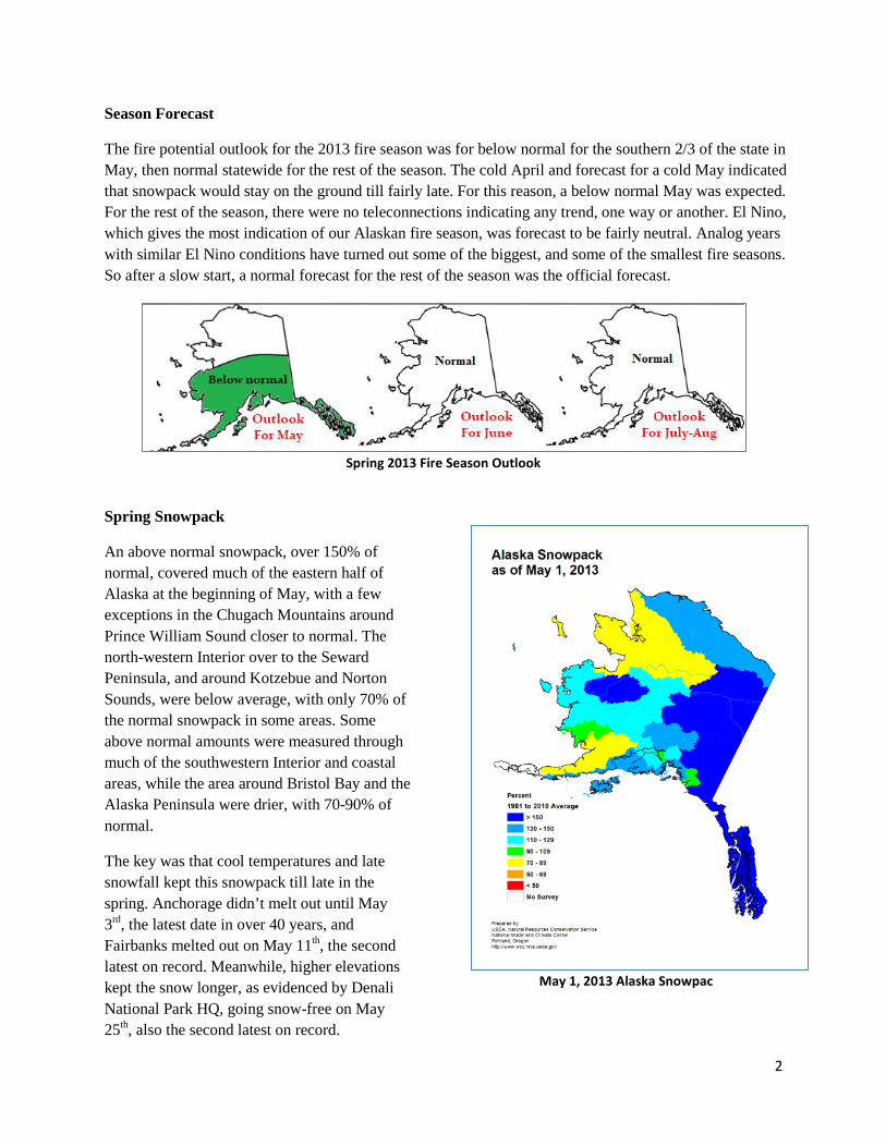
Season Forecast
The fire potential outlook for the 2013 fire season was for below normal for the southern 2/3 of the state in May, then normal statewide for the rest of the season. The cold April and forecast for a cold May indicated that snowpack would stay on the ground till fairly late. For this reason, a below normal May was expected. For the rest of the season, there were no teleconnections indicating any trend, one way or another. El Nino, which gives the most indication of our Alaskan fire season, was forecast to be fairly neutral. Analog years with similar El Nino conditions have turned out some of the biggest, and some of the smallest fire seasons. So after a slow start, a normal forecast for the rest of the season was the official forecast.
Spring 2013 Fire Season Outlook
Spring Snowpack
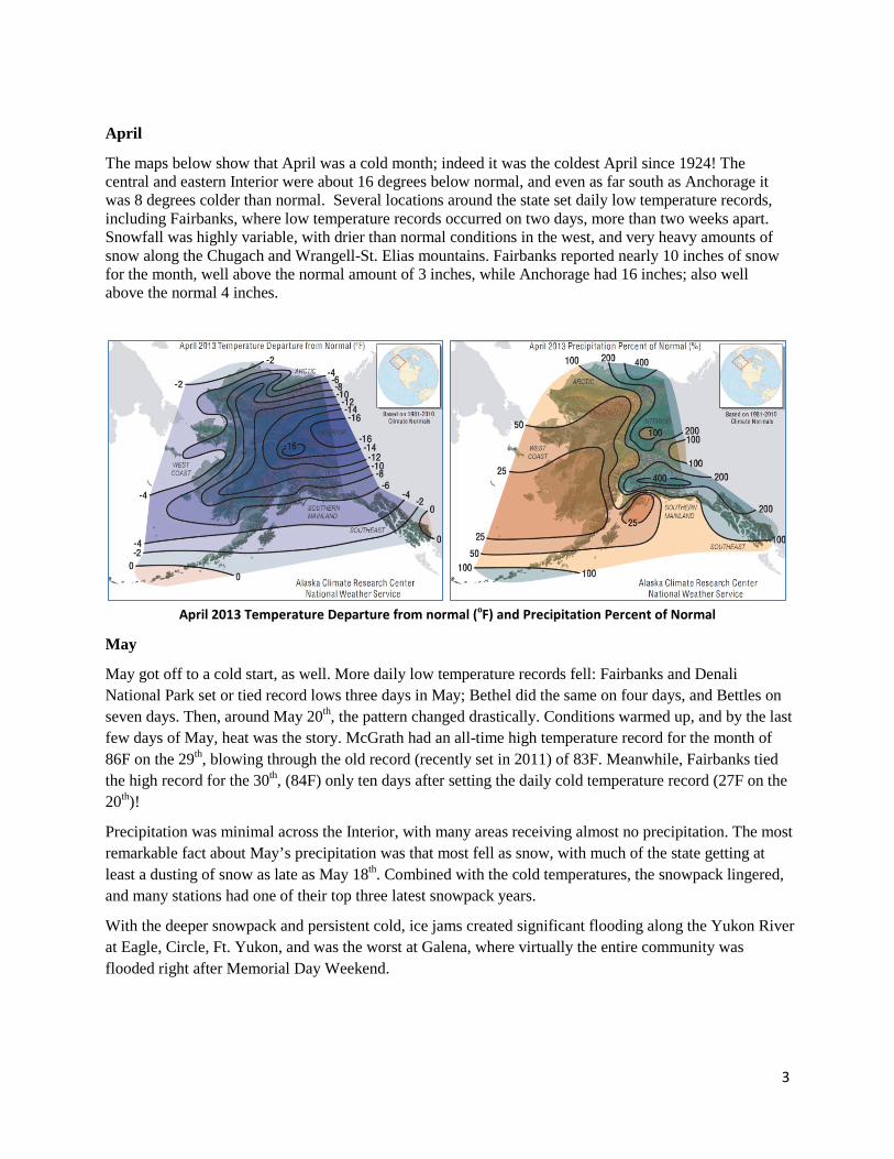
An above normal snowpack, over 150% of normal, covered much of the eastern half of Alaska at the beginning of May, with a few exceptions in the Chugach Mountains around Prince William Sound closer to normal. The north-western Interior over to the Seward Peninsula, and around Kotzebue and Norton Sounds, were below average, with only 70% of the normal snowpack in some areas. Some above normal amounts were measured through much of the southwestern Interior and coastal areas, while the area around Bristol Bay and the Alaska Peninsula were drier, with 70-90% of normal.
The key was that cool temperatures and late snowfall kept this snowpack till late in the spring. Anchorage didn’t melt out until May 3rd, the latest date in over 40 years, and Fairbanks melted out on May 11th, the second latest on record. Meanwhile, higher elevations kept the snow longer, as evidenced by Denali National Park HQ, going snow-free on May 25th, also the second latest on record.
May 1, 2013 Alaska Snowpac
3
April
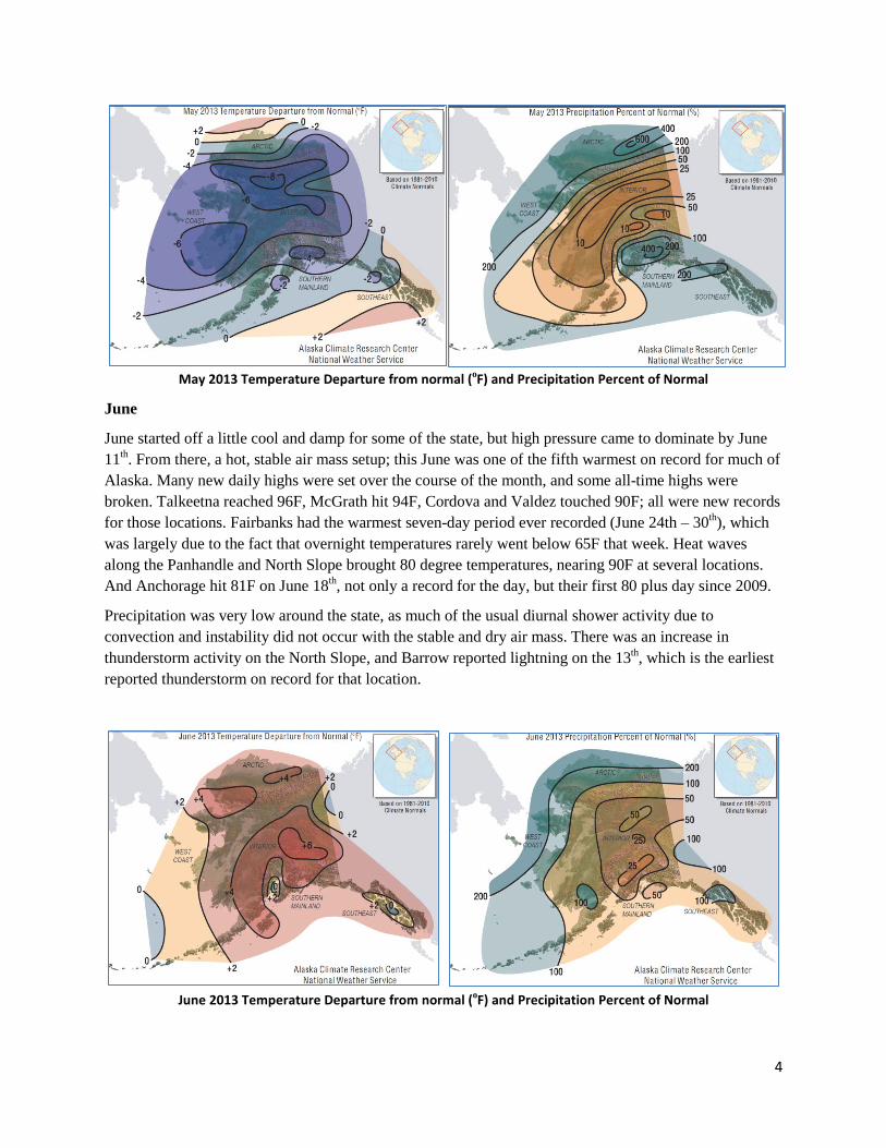
The maps below show that April was a cold month; indeed it was the coldest April since 1924! The central and eastern Interior were about 16 degrees below normal, and even as far south as Anchorage it was 8 degrees colder than normal. Several locations around the state set daily low temperature records, including Fairbanks, where low temperature records occurred on two days, more than two weeks apart. Snowfall was highly variable, with drier than normal conditions in the west, and very heavy amounts of snow along the Chugach and Wrangell-St. Elias mountains. Fairbanks reported nearly 10 inches of snow for the month, well above the normal amount of 3 inches, while Anchorage had 16 inches; also well above the normal 4 inches.
April 2013 Temperature Departure from normal (oF) and Precipitation Percent of Normal
May
May got off to a cold start, as well. More daily low temperature records fell: Fairbanks and Denali National Park set or tied record lows three days in May; Bethel did the same on four days, and Bettles on seven days. Then, around May 20th, the pattern changed drastically. Conditions warmed up, and by the last few days of May, heat was the story. McGrath had an all-time high temperature record for the month of 86F on the 29th, blowing through the old record (recently set in 2011) of 83F. Meanwhile, Fairbanks tied the high record for the 30th, (84F) only ten days after setting the daily cold temperature record (27F on the 20th)!
Precipitation was minimal across the Interior, with many areas receiving almost no precipitation. The most remarkable fact about May’s precipitation was that most fell as snow, with much of the state getting at least a dusting of snow as late as May 18th. Combined with the cold temperatures, the snowpack lingered, and many stations had one of their top three latest snowpack years.
With the deeper snowpack and persistent cold, ice jams created significant flooding along the Yukon River at Eagle, Circle, Ft. Yukon, and was the worst at Galena, where virtually the entire community was flooded right after Memorial Day Weekend.
4
May 2013 Temperature Departure from normal (oF) and Precipitation Percent of Normal
June
June started off a little cool and damp for some of the state, but high pressure came to dominate by June 11th. From there, a hot, stable air mass setup; this June was one of the fifth warmest on record for much of Alaska. Many new daily highs were set over the course of the month, and some all-time highs were broken. Talkeetna reached 96F, McGrath hit 94F, Cordova and Valdez touched 90F; all were new records for those locations. Fairbanks had the warmest seven-day period ever recorded (June 24th – 30th), which was largely due to the fact that overnight temperatures rarely went below 65F that week. Heat waves along the Panhandle and North Slope brought 80 degree temperatures, nearing 90F at several locations. And Anchorage hit 81F on June 18th, not only a record for the day, but their first 80 plus day since 2009.
Precipitation was very low around the state, as much of the usual diurnal shower activity due to convection and instability did not occur with the stable and dry air mass. There was an increase in thunderstorm activity on the North Slope, and Barrow reported lightning on the 13th, which is the earliest reported thunderstorm on record for that location.
June 2013 Temperature Departure from normal (oF) and Precipitation Percent of Normal
5
July
The first week of July brought a little reprieve with cooler temperatures and a bit of precipitation. A cold July 4th brought record lows to parts of the Interior where temperatures dropped into the 30s overnight. Then it quickly got hot again. More long-term records were broken. Anchorage broke the 2004 record (13 days) of most consecutive days of 70F and higher on 15 consecutive days that month (July 17th – 31st). Fairbanks broke the 2004 record (30 days) of most days over 80F with 36 days, and also broke the 1987 record (10 days) of most days over 85F with 14 days.
Even the Panhandle could not escape the heat. Record highs were set there at the middle and again at the end of the month: 84F at Annette, 87F at Hyder, and 86F at Hollis and the Haines Highway Customs Station.
Precipitation was sparse for July, with very few exceptions. The first week of the month did bring rain for much of the state, but that was short lived as high pressure came back to dominate the rest of the month. The map indicates how location made a big difference with showery precipitation across the Interior: Denali Park’s Eielson Visitor Center received 8.55” of rain in July, more than four times what the main Denali Visitor Center/HQ received! Again, thunderstorms were lacking, though a few were reported, including at Juneau (downpours with dime-size hail north of town on July 13th) and Kenai (near record-rate rainfall for an hour on July 26th).
Smoke was an issue for communities in Southwest Alaska, as well as around parts of the Interior. With the hot, stable weather, there were quite a few mornings when smoke was observed, at varying degrees of particulate levels. This provided concern not only for health issues, but for operational issues including visibility on affected runways.
July 2013 Temperature Departure from normal (oF) and Precipitation Percent of Normal
6
August
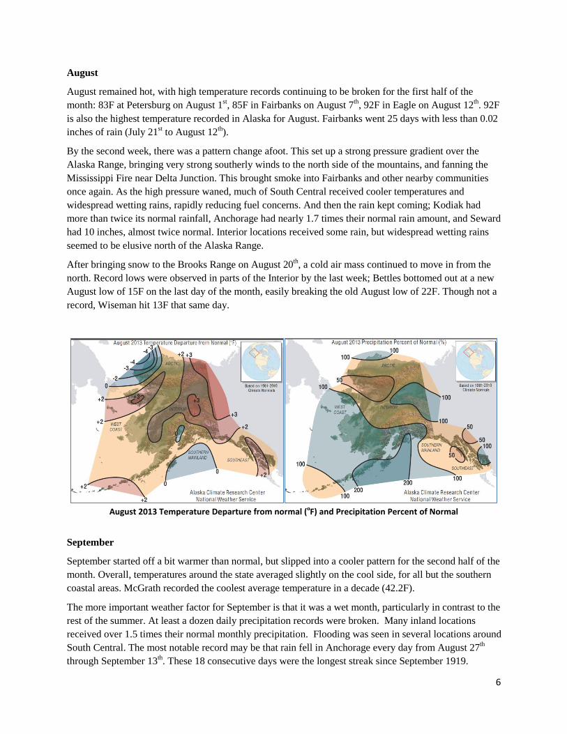
August remained hot, with high temperature records continuing to be broken for the first half of the month: 83F at Petersburg on August 1st, 85F in Fairbanks on August 7th, 92F in Eagle on August 12th. 92F is also the highest temperature recorded in Alaska for August. Fairbanks went 25 days with less than 0.02 inches of rain (July 21st to August 12th).
By the second week, there was a pattern change afoot. This set up a strong pressure gradient over the Alaska Range, bringing very strong southerly winds to the north side of the mountains, and fanning the Mississippi Fire near Delta Junction. This brought smoke into Fairbanks and other nearby communities once again. As the high pressure waned, much of South Central received cooler temperatures and widespread wetting rains, rapidly reducing fuel concerns. And then the rain kept coming; Kodiak had more than twice its normal rainfall, Anchorage had nearly 1.7 times their normal rain amount, and Seward had 10 inches, almost twice normal. Interior locations received some rain, but widespread wetting rains seemed to be elusive north of the Alaska Range.
After bringing snow to the Brooks Range on August 20th, a cold air mass continued to move in from the north. Record lows were observed in parts of the Interior by the last week; Bettles bottomed out at a new August low of 15F on the last day of the month, easily breaking the old August low of 22F. Though not a record, Wiseman hit 13F that same day.
August 2013 Temperature Departure from normal (oF) and Precipitation Percent of Normal
September
September started off a bit warmer than normal, but slipped into a cooler pattern for the second half of the month. Overall, temperatures around the state averaged slightly on the cool side, for all but the southern coastal areas. McGrath recorded the coolest average temperature in a decade (42.2F).
The more important weather factor for September is that it was a wet month, particularly in contrast to the rest of the summer. At least a dozen daily precipitation records were broken. Many inland locations received over 1.5 times their normal monthly precipitation. Flooding was seen in several locations around South Central. The most notable record may be that rain fell in Anchorage every day from August 27th through September 13th. These 18 consecutive days were the longest streak since September 1919.
7
The cooler weather that arrived mid-month seemed to bring winter along with it, a bit on the early side. Eagle had more than a foot of snow for the month, making it the second snowiest September on record there. September 18th saw the first measureable snowfall in Fairbanks, 12 days earlier than normal, making it the 4th shortest summer (summer defined as the period having no snow on the ground) on record. An early snow was also observed in Anchorage, where a couple of inches were reported on September 22nd.
Fall usually brings stronger winds, and this September held true. The first large system brought strong winds to the northern Interior around September 3rd, while South Central closed out the month with another windstorm on the 25th of the month. Whenever the winds picked up through the Alaska Range, the Mississippi Fire responded with a sudden increase in activity, keeping fire suppression officers on their toes, and some smoke still intruding into nearby communities.
September 2013 Temperature Departure from normal (oF) and Precipitation Percent of Normal
500 mb Patterns
In April and May, lower than normal height anomalies dominated first the eastern half of the state (April), and then almost all of the state north of the Alaska Range (May). This would explain why colder than normal temperatures were widespread through most of the spring. For June, the mean heights show that ridging centered over Canada stretched over Alaska. Though this is a normal pattern, the anomaly map shows that the ridge held stronger (and more persistent) high pressure over the entire state, and that much stronger ridging than normal was positioned over southwestern Alaska.
July's mean height map indicates that ridging was generally present over the ALCAN border. The anomalies were again leaning toward higher heights, with high pressure setup over the north Pacific. This was likely a key factor in making this one of the top five warmest summers for so much of the state; usually July brings cooler temperatures, and that didn't happen in 2013.
August's anomaly map shows that lower than normal heights moved into the west coast from the south. With the longwave trough that dominated the composite mean for the month, this indicates low pressure was the rule for that part of the state, which goes hand in hand with the cooler weather and moisture moving into southern Alaska at that time. During September, that longwave trough seems to have deepened, and the area of lower height anomalies expanded to the east, enveloping much of Alaska. This would explain the long rainy stretches in parts of Southwest and South Central Alaska at the beginning of September.
8
`
Composite Mean Analyses and Anomalies of 500 mb Geopotential Heights (m) for April, May, June 2013
9
`
Composite Mean Analyses and Anomalies of 500 mb Geopotential Heights (m) for July, August, September 2013
10
Lightning
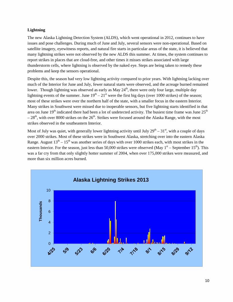
The new Alaska Lightning Detection System (ALDS), which went operational in 2012, continues to have issues and pose challenges. During much of June and July, several sensors were non-operational. Based on satellite imagery, eyewitness reports, and natural fire starts in particular areas of the state, it is believed that many lightning strikes were not observed by the new ALDS this summer. At times, the system continues to report strikes in places that are cloud-free, and other times it misses strikes associated with large thunderstorm cells, where lightning is observed by the naked eye. Steps are being taken to remedy these problems and keep the sensors operational.
Despite this, the season had very low lightning activity compared to prior years. With lightning lacking over much of the Interior for June and July, fewer natural starts were observed, and the acreage burned remained lower. Though lightning was observed as early as May 24th, there were only four large, multiple day lightning events of the summer. June 19th – 21st were the first big days (over 1000 strikes) of the season; most of these strikes were over the northern half of the state, with a smaller focus in the eastern Interior. Many strikes in Southwest were missed due to inoperable sensors, but five lightning starts identified in that area on June 19th indicated there had been a lot of undetected activity. The busiest time frame was June 25th – 28th, with over 8000 strikes on the 26th. Strikes were focused around the Alaska Range, with the most strikes observed in the southeastern Interior.
Most of July was quiet, with generally lower lightning activity until July 29th – 31st, with a couple of days over 2000 strikes. Most of these strikes were in Southwest Alaska, stretching over into the eastern Alaska Range. August 13th – 15th was another series of days with over 1000 strikes each, with most strikes in the eastern Interior. For the season, just less than 50,000 strikes were observed (May 1st – September 15th). This was a far cry from that only slightly hotter summer of 2004, when over 175,000 strikes were measured, and more than six million acres burned.
0
2
4
6
8
10
Thou
sand
s
Alaska Lightning Strikes 2013
11
Conclusion
2013 will be remembered as one of the shortest, but hottest summers on record. After a cold spring and snowy May, temperatures ramped up by June, and conditions stayed hot and dry till the end of August, with only a little precipitation. Fuel conditions reached near record dryness at some locations, spurring the issuance of three Fuels and Fire Behavior Advisories. Despite many record-setting hot temperatures, the stable high pressure kept thunderstorms at bay, and lightning to a minimum. The end of August heralded a cold and wet month, finally wetting fuels across the state.
With many comparisons between the hot, dry summers of 2004 and 2013, it seems that the lack of lightning, and therefore the lack of natural fire starts, is what kept the 2013 fire season from becoming catastrophic.
Contacts
This summary was put together by Heidi Strader and Sharon Alden. Please contact Heidi at 907-356-5691, or via email at [email protected] if you have any questions or concerns about this document.