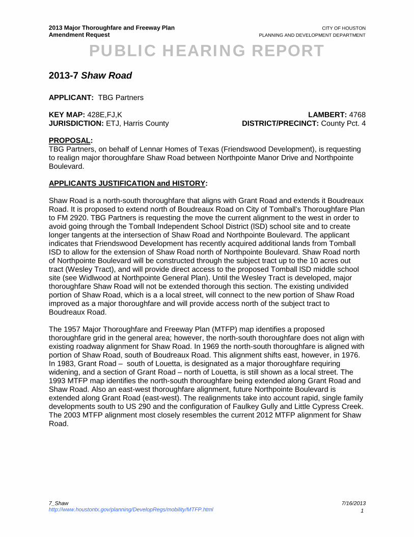
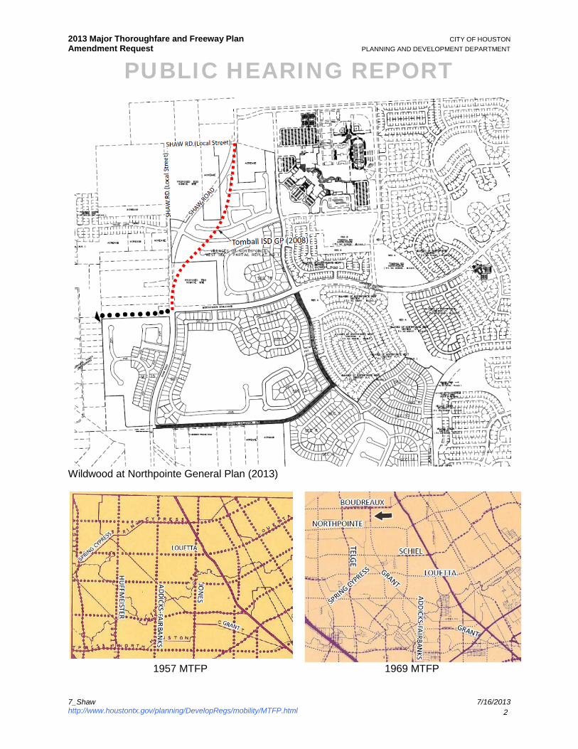
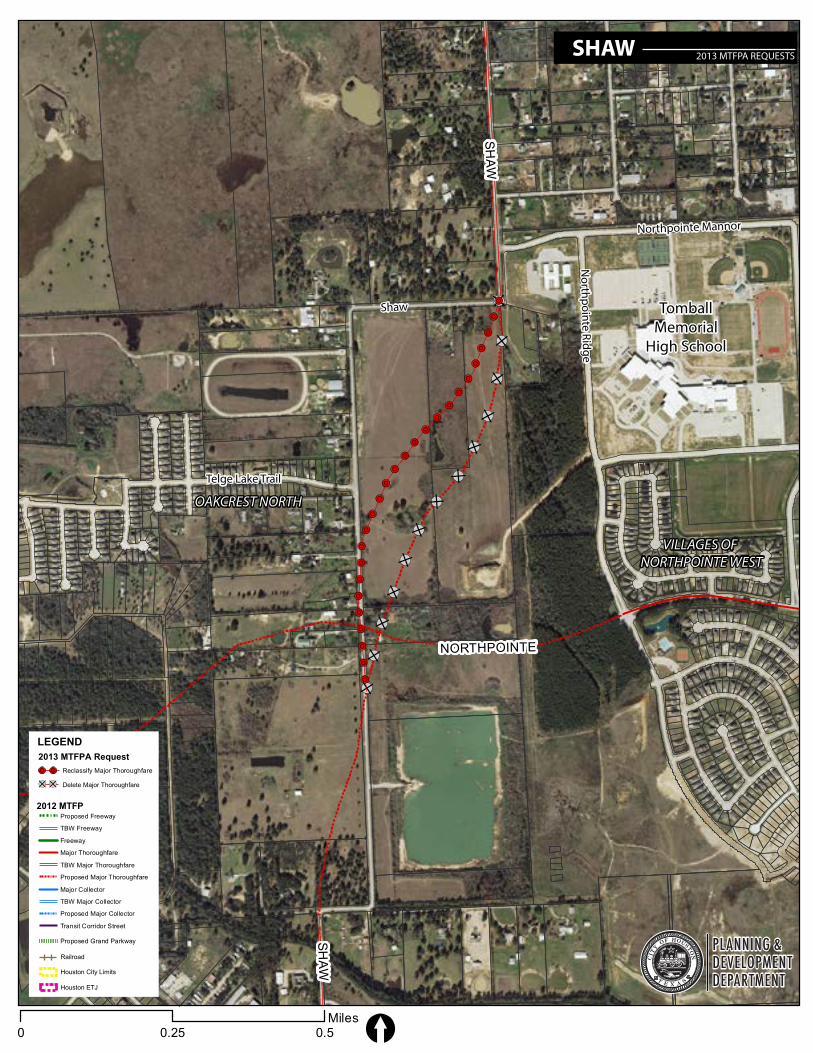
2013 Major Thoroughfare and Freeway Plan CITY OF HOUSTON Amendment Request PLANNING AND DEVELOPMENT DEPARTMENT PUBLIC HEARING REPORT 7_Shaw 7/16/2013 http://www.houstontx.gov/planning/DevelopRegs/mobility/MTFP.html 1 2013-7 Shaw Road APPLICANT: TBG Partners KEY MAP: 428E,FJ,K LAMBERT: 4768 JURISDICTION: ETJ, Harris County DISTRICT/PRECINCT: County Pct. 4 PROPOSAL: TBG Partners, on behalf of Lennar Homes of Texas (Friendswood Development), is requesting to realign major thoroughfare Shaw Road between Northpointe Manor Drive and Northpointe Boulevard. APPLICANTS JUSTIFICATION and HISTORY: Shaw Road is a north-south thoroughfare that aligns with Grant Road and extends it Boudreaux Road. It is proposed to extend north of Boudreaux Road on City of Tomball’s Thoroughfare Plan to FM 2920. TBG Partners is requesting the move the current alignment to the west in order to avoid going through the Tomball Independent School District (lSD) school site and to create longer tangents at the intersection of Shaw Road and Northpointe Boulevard. The applicant indicates that Friendswood Development has recently acquired additional lands from Tomball ISD to allow for the extension of Shaw Road north of Northpointe Boulevard. Shaw Road north of Northpointe Boulevard will be constructed through the subject tract up to the 10 acres out tract (Wesley Tract), and will provide direct access to the proposed Tomball lSD middle school site (see Widlwood at Northpointe General Plan). Until the Wesley Tract is developed, major thoroughfare Shaw Road will not be extended thorough this section. The existing undivided portion of Shaw Road, which is a a local street, will connect to the new portion of Shaw Road improved as a major thoroughfare and will provide access north of the subject tract to Boudreaux Road. The 1957 Major Thoroughfare and Freeway Plan (MTFP) map identifies a proposed thoroughfare grid in the general area; however, the north-south thoroughfare does not align with existing roadway alignment for Shaw Road. In 1969 the north-south thoroughfare is aligned with portion of Shaw Road, south of Boudreaux Road. This alignment shifts east, however, in 1976. In 1983, Grant Road – south of Louetta, is designated as a major thoroughfare requiring widening, and a section of Grant Road – north of Louetta, is still shown as a local street. The 1993 MTFP map identifies the north-south thoroughfare being extended along Grant Road and Shaw Road. Also an east-west thoroughfare alignment, future Northpointe Boulevard is extended along Grant Road (east-west). The realignments take into account rapid, single family developments south to US 290 and the configuration of Faulkey Gully and Little Cypress Creek. The 2003 MTFP alignment most closely resembles the current 2012 MTFP alignment for Shaw Road.
Transcript
2013 Major Thoroughfare and Freeway Plan CITY OF HOUSTON Amendment Request PLANNING AND DEVELOPMENT DEPARTMENT
2013-7 Shaw Road APPLICANT: TBG Partners KEY MAP: 428E,FJ,K LAMBERT: 4768 JURISDICTION: ETJ, Harris County DISTRICT/PRECINCT: County Pct. 4 PROPOSAL: TBG Partners, on behalf of Lennar Homes of Texas (Friendswood Development), is requesting to realign major thoroughfare Shaw Road between Northpointe Manor Drive and Northpointe Boulevard. APPLICANTS JUSTIFICATION and HISTORY: Shaw Road is a north-south thoroughfare that aligns with Grant Road and extends it Boudreaux Road. It is proposed to extend north of Boudreaux Road on City of Tomball’s Thoroughfare Plan to FM 2920. TBG Partners is requesting the move the current alignment to the west in order to avoid going through the Tomball Independent School District (lSD) school site and to create longer tangents at the intersection of Shaw Road and Northpointe Boulevard. The applicant indicates that Friendswood Development has recently acquired additional lands from Tomball ISD to allow for the extension of Shaw Road north of Northpointe Boulevard. Shaw Road north of Northpointe Boulevard will be constructed through the subject tract up to the 10 acres out tract (Wesley Tract), and will provide direct access to the proposed Tomball lSD middle school site (see Widlwood at Northpointe General Plan). Until the Wesley Tract is developed, major thoroughfare Shaw Road will not be extended thorough this section. The existing undivided portion of Shaw Road, which is a a local street, will connect to the new portion of Shaw Road improved as a major thoroughfare and will provide access north of the subject tract to Boudreaux Road. The 1957 Major Thoroughfare and Freeway Plan (MTFP) map identifies a proposed thoroughfare grid in the general area; however, the north-south thoroughfare does not align with existing roadway alignment for Shaw Road. In 1969 the north-south thoroughfare is aligned with portion of Shaw Road, south of Boudreaux Road. This alignment shifts east, however, in 1976. In 1983, Grant Road – south of Louetta, is designated as a major thoroughfare requiring widening, and a section of Grant Road – north of Louetta, is still shown as a local street. The 1993 MTFP map identifies the north-south thoroughfare being extended along Grant Road and Shaw Road. Also an east-west thoroughfare alignment, future Northpointe Boulevard is extended along Grant Road (east-west). The realignments take into account rapid, single family developments south to US 290 and the configuration of Faulkey Gully and Little Cypress Creek. The 2003 MTFP alignment most closely resembles the current 2012 MTFP alignment for Shaw Road.
2013 Major Thoroughfare and Freeway Plan CITY OF HOUSTON Amendment Request PLANNING AND DEVELOPMENT DEPARTMENT
Population & Employment Projections: According to 2010 Census, Texas grew by 20% in ten years, to over 25 million people, recording about a quarter of the nation’s overall growth. The rate of growth in Texas was twice the national average. Harris County is the most populous county (4 million) in Texas. Today, 2.1 million people live within the City of Houston and another 2 million live in the City’s extraterritorial jurisdiction (ETJ). Since 2000, the City of Houston added 146,000 people (8 %) to its population. Houston’s ETJ however grew 35 % during the same time period. Houston and its ETJ’s rich employment sector are home to more than 1.8 million jobs, making it the state’s most populous and robust economic center. More than one million jobs are located within the City limits and are saturated within the City’s eight major activity centers.
2013 Major Thoroughfare and Freeway Plan CITY OF HOUSTON Amendment Request PLANNING AND DEVELOPMENT DEPARTMENT
One of the greatest challenges to Houston’s mobility is that by 2035 significant numbers of residents are projected to live outside the City limits in the ETJ; while the major employment growth is expected to occur within the City limits. This increase in distance between the population and employment centers will result in more travel, greater travel time, and longer travel delays. In addition to anticipated growth within the ETJ, an additional 550,000 new residents are expected within the current city limits. The most notable population growth is projected to occur inside Loop 610. It reflects efforts to create a dense urban core through mixed-use development strategies. To compare the result between 2000 and 2010 Census, the subject area’s population grew by 263% from 4,325 to 15,735 which demonstrates a percent change significantly higher than that of Harris County’s growth (20%). The Houston-Galveston Area Council (H-GAC) projects that over the next 25 years (2010 – 2035), the population within the study area* will increase from 15,703 to 24,185 (8,482 persons), or 54%. The number of persons per acre is projected to increase from approximately 3.0 to approximately 4.6. During the same period, H-GAC estimates that the total jobs in the subject area will increase from 1,101 to 1,122 (21 jobs), or 1.9%. The number of jobs per acre is projected to remain approximately 0.2.
Expressed in percentages, the subject area’s population growth is expected to be more than the Houston ETJ’s (54% vs. 53%), and the area’s job growth is less than the Houston ETJ’s (1.9% vs. 85%).
Change (2010 to 2035) 1.6 54.0% 0.8 77.5% 0.0 1.9% City of Houston Change
(2010 to 2035) 1.6 30.4% 0.6 32.4% 1.3 32.9%
City of Houston ETJ Change (2010 to 2035) 1.3 53.4% 0.6 73.7% 0.6 85.6%
Source: H-GAC’s 2035 Regional Growth Forecast * Data represents population, jobs, and households in 2 Traffic Analysis Zones (TAZ) encompassing approximately 5,229 acres around the proposed amendment. Population projections do not include projections for group housing.
2013 Major Thoroughfare and Freeway Plan CITY OF HOUSTON Amendment Request PLANNING AND DEVELOPMENT DEPARTMENT
Land Use and Platting Activity: The majority of development along the Northpointe corridor is single-family residential in nature. Accordingly, platting activity in the general area of the Shaw Road MTFP amendment request served to enhance the residential landscape. Over the last five years, 526 single family lots have been platted on approximately 250 acres, and represents 95% of the platting activity in the area. Commercial properties comprise only 8 acres of the total area platted. Tomball ISD has a large High School campus east of Shaw Road as well as two additional Tomball ISD tracts adjacent to proposed Shaw Road alignment. Subdivision Plat Name Action Date Key Map Land Use Property
Size (ac) No. of Lots
Grant Meadows GP 30-Aug-12 328J SF Residential (public street) 93.2 Oakcrest North Sec 6 3-Jan-13 328E SF Residential (public street) 9.2 36
Grant Meadows Sec 4 13-Dec-12 328J SF Residential (public street) 10.1 51
Wildwood at Northpointe Sec 11 13-Sep-12 328K SF Residential (Type 1 PAE) 16.4 40
Wildwood at Northpointe Sec 12 13-Sep-12 328K SF Residential (Type 1 PAE) 13.5 40
Oakcrest North Sec 9 30-Aug-12 328E SF Residential (public street) 11.2 40
Grant Meadows Sec 3 30-Aug-12 328J SF Residential (public street) 16.2 67
Wildwood at Northpointe GP 14-Feb-13 328K General Plan 287.1 Wildwood at Northpointe Sec 9 30-Aug-12 328K SF Residential (public street) 8.0 29
Wildwood at Northpointe Sec 7 16-Aug-12 328k SF Residential (Type 1 PAE) 10.2 33
Enclave at Northpointe GP 5-Jul-12 328K General Plan 108.7 Enclave at Northpointe Sec 1 5-Jul-12 328K SF Residential (Type 1 PAE) 16.9 58
Enclave at Northpointe Sec 2 5-Jul-12 328K SF Residential (Type 1 PAE) 13.5 42
Wildwood at Northpointe Sec 8 7-Jun-12 328K SF Residential (public street) 8.0 31 Oakcrest North Sec 5 partial replat no 1 12-Apr-12 328E SF Residential (public street) 4.3 Mak and Mar Plaza 16-Feb-12 328B Commercial 3.0 Villages of Northpointe West Sec 3 partial replat no 1 16-Feb-12 328F Unrestricted 0.0
Wildwood at Northpointe Sec 5 16-Feb-12 328K SF Residential (public street) 14.9 45
Wildwood at Northpointe Sec 6 16-Feb-12 328K SF Residential (public street) 4.5 14
Patton Myhre 2-Feb-12 328B Commercial 5.0 Northpointe Blvd From Northpointe Ridge Ln to Shaw Rd STD
19-Jan-12 328k Other 5.2
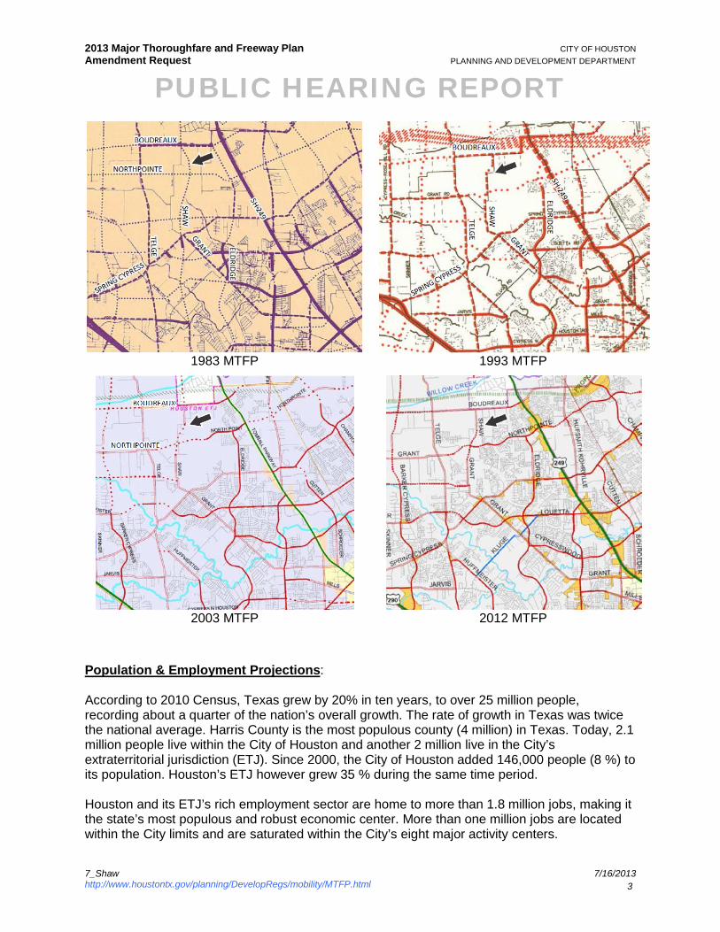
Right-Of-Way (ROW) Status: Shaw Road is a proposed north-south thoroughfare that aligns with Grant Road and extends to Boudreaux Road. ROW for Northpointe Boulevard has been dedicated east of Shaw Road however is a proposed Major Thoroughfare on the west side of Shaw Road. Telge Road, Boudreaux Road, and Grant Road are “to be widened” as recognized by the MTFP. Other major thoroughfares in the general area are planned for 4-lanes and 100’ ROW.
2013 Major Thoroughfare and Freeway Plan CITY OF HOUSTON Amendment Request PLANNING AND DEVELOPMENT DEPARTMENT
Spacing: Shaw Road provides the only north-south connection through the provided study area located approximately 1.35 miles east of Telge Road and 1.5 miles west of Tomball Parkway. The corridor runs parallel to North Eldridge Parkway which is located 2.10 miles west of the corridor but, unlike Shaw Road, terminates at Grant Road /Northpointe Boulevard.
Street From To Classification Direction Spacing Shaw Boudreaux Palico T-4-100 N-S 0.62 mile