Page 1
ALBERTA TRANSPORTATION
2014-17 Tentative Major Construction Projects 2014/15 – 2016/17
Provincial Highway, Water Management, and Flood Related Projects Major Provincial Highway Water Management Flood Related
The attached tentative three-year construction and rehabilitation program lists the major projects where substantive work is anticipated to be complete or undertaken between 2014/15 and 2016/17, subject to provincial funding and priorities.
Projects that are under contract or tendered are identified stating the year of
construction. Other projects are being designed, right-of-way being negotiated and the acquisition of
permits underway. These projects will commence as planned in the three year program dependent upon the timely completion of the design, and availability of budget.
Minor changes to the program may be required as newer information becomes available. In particular, final paving, pavement overlays and bridge rehabilitation may be added and/or deleted from the program depending on how the roadway or bridge condition changes throughout the year.
Not identified in the program are some of the bridge rehabilitation projects and localized improvements, such as: minor slide repairs and intersection upgrades; small carry-over projects from 2013/14; and general expenditures such as chip seal coats, lighting, preliminary (consultant) engineering and future right-of-way. Additionally, minor safety-related improvements might be added as identified, generally in conjunction with larger projects.
Page 2
GLOSSARYThis is a listing of abbreviations used in the following document
@ AtAve AvenueBdry BoundaryBF 74817 or (74817-02) Bridge File NumberCNR Canadian National RailwayCr CreekCty County(E) East JunctionE EastEB or EBL East Bound LaneECL East Corporate (or City) LimitEID Eastern Irrigation DistrictG/S Grade Separation StructureHwy HighwayIncl IncludesImp ImprovementInt IntersectionIntch InterchangeIR Indian ReserveJct JunctionLR Local Road(N) North JunctionN NorthNB or NBL North Bound LaneNCL North Corporate (or City) LimitR or Riv RiverRge RangeRd or Rds Road or Roads(S) South JunctionS SouthSB or SBL South Bound LaneSCL South Corporate (or City) Limitsel selectiveSRA Safety Rest AreaSt StreetSV Summer VillageTr TrailTwp TownshipUAR Urban Approach RoadVIS Vehicle Inspection Station(W) West JunctionW WestWB or WBL West Bound LaneWCL West Corporate (or City) LimitWID Western Irrigation District
Page 3
Highway Location Type of WorkEstimatedLength (km)
Tentative Government-Owned Transportation ProjectsNear Completion, Underway or Scheduled
in 2014-2017Major Provincial Highway, Water Management, and Flood Related Projects
(Major Construction and Rehabilitation)
Major Provincial Highway
1 Preservation/Overlay 38Contract for 2013 & 2014 Construction
4 km W of Bow Valley Trail - 1 km E of Hwy 1X (selective)(Banff National Park E Bdry to the Kananaskis River)
1 Preservation/Overlay 381 km E of Hwy 1X - 3 km W of Hwy 68 (selective)
1 Preservation/Overlay 32East Boundary Stony Indian Reserve to West of Hwy 22
1 Preservation/Overlay 21Hwy 797 - Town of Strathmore (WBL)
1 Preservation/Overlay 21Hwy 797 - Town of Strathmore (EBL)
1 Preservation/Overlay 6420 km W of Hwy 884 - 1 km W of Hwy 524 (selective)
1 Interchange - Grade, Base, PavingContract for 2013 & 2014 Construction
Highway 1 and Dunmore Road
1 Interchange - Bridge StructureContract for 2013 & 2014 Construction
Dunmore Road Over Hwy1, Medicine Hat (84536-E)
1 Interchange - Bridge StructureContract for 2013 & 2014 Construction
Dunmore Road Over Hwy1, Medicine Hat (84536-W)
1 Preservation/Overlay 241 km E of Hwy 41 - 25 km E of Hwy 41
1A Preservation/Overlay 206 km E of Hwy 22 - 18 km W of Hwy 201 (selective)
1A Twinning - 2nd Stage Paving 64 km E of Hwy 22 - 2 km W of Hwy 766
1A Signalization / LightingSignalization at Hwy 1A & Centre Avenue, Town of Cochrane
1X Preservation/Overlay 6Hwy 1 - Hwy 1A selective
1X Bridge RehabilitationContract for 2014 Construction
Bow River Bridge on Highway 1X, at N Boundary of Seebe (75111-1)
2 Bridge RehabilitationHighway 567 Over Highway 2 Interchange, at N Boundary of Airdrie (76848-1)
2 Preservation/Overlay 42Contract for 2013 & 2014 Construction
1 km N of Hwy 590 - City of Red Deer (NBL & SBL)
Monday, March 03, 2014 Page 1 of 21
Page 4
Highway Location Type of WorkEstimatedLength (km)
Tentative Government-Owned Transportation ProjectsNear Completion, Underway or Scheduled
in 2014-2017Major Provincial Highway, Water Management, and Flood Related Projects
(Major Construction and Rehabilitation)
Major Provincial Highway
2 Structure ReplacementWolf Creek Bridge on Highway 2, 9 km SW of Ponoka (75623-1)
2 Structure ReplacementWolf Creek Bridge on Highway 2, 9 km SW of Ponoka (75623-2)
2 Interchange - Grade, Base, PavingContract for 2013, 2014, & 2015 Construction
Interchange @ 41 Ave SW Edmonton
2 Bridge Rehabilitation50 Street Over Highway 2 Interchange, at NW Boundary of Leduc (77994-1)
2 Preservation/Overlay 9Vimy Approach Road (UAR 79) - Hwy 18
2 Preservation/Overlay 12Hwy 37 - Town of Morinville
2 Preservation/Overlay 22Morinville - N of Hwy 18 (selective)
2 Signalization / LightingIntersection Signalization and Other Work (Cardiff Road Intersection)
2 Preservation/Overlay 39Hwy 44 - 15 km S of Town of Slave Lake
2 Structure ReplacementLittle Sucker Culvert on Provincial Highway 2 near Joussard (76479-1)
2 Structure ReplacementSucker Creek (Arcadia Creek Bridge ) on Highway 2, 12 km E of Enilda (76478-1)
2 Preservation/Overlay 38N of Hwy 49 - N of Hwy 683
2 Reconstruct/Re-Alignment 2Contract for 2014 Construction
Road Realignment for Heart River Bridge (BF13117) near Nampa
2 Structure ReplacementContract for 2012 & 2014 Construction
Heart River Bridge on Highway 2, 2 km N of Nampa (13117-1)
2 Structure ReplacementWatercourse Culvert on Hwy 2 near Rycroft (86265-1)
2 Preservation/Overlay 52 km N of Hwy 672 - 3 km N of Hwy 672
2 Preservation/Overlay 14 km N of Hwy 672 - 5 km S of Hwy 43X
Monday, March 03, 2014 Page 2 of 21
Page 5
Highway Location Type of WorkEstimatedLength (km)
Tentative Government-Owned Transportation ProjectsNear Completion, Underway or Scheduled
in 2014-2017Major Provincial Highway, Water Management, and Flood Related Projects
(Major Construction and Rehabilitation)
Major Provincial Highway
2 Preservation/Overlay 1512 km N of Hwy 59 - Town of Sexsmith (selective)
2 Intersection ImprovementHwy 2 & 100 Street, Hamlet of Clairmont (includes traffic signals)
2A Signalization / LightingSignalization at Hwy 2A and Dunbow Road
2A Intersection ImprovementRoundabout at 2A/597
2A Preservation/Overlay 4City of Lacombe - N of City of Lacombe
2A Preservation/Overlay 12Hwy 2 - S of Hwy 53 (selective)
2A Preservation/Overlay 11 km S of Hwy 2 - Hwy 2
2A Structure ReplacementNoon Creek Bridge on Provincial Highway 02a near High Prairie (73781-1)
3 Bridge RehabilitationCPR Overpass on Highway 3, at Crowsnest Pass (75744-1)
3 Structure ReplacementCrowlodge Creek Culvert on Highway 3, 18 km SW of Fort Macleod (70887-1)
3 Preservation/Overlay 22Hwy 3A - City of Lethbridge
3 Major Girder Repairs on BridgesOldman River Bridge on Highway 3, at Lethbridge (1074-1)
6 Structure ReplacementIndian Farm Creek Culvert on Provincial Highway 6 near Pincher Creek (74271-1)
9 Preservation/Overlay 19Hwy 838 - Hwy 27
11 Preservation/Overlay 314 km E of Hwy 22 - 2 km W of Benalto Access (selective)
11 Preservation/Overlay 21 km W of Hwy 11A - Town of Rocky Mountain House (selective)
11 Structure ReplacementWatercourse Culvert on Provincial Highway 11 near Benalto (72356-1)
Monday, March 03, 2014 Page 3 of 21
Page 6
Highway Location Type of WorkEstimatedLength (km)
Tentative Government-Owned Transportation ProjectsNear Completion, Underway or Scheduled
in 2014-2017Major Provincial Highway, Water Management, and Flood Related Projects
(Major Construction and Rehabilitation)
Major Provincial Highway
11 Preservation/Overlay 289 km W of Hwy 921 - Hwy 12
12 Preservation/Overlay 46Hwy 50 - Town of Stettler
13 Structure ReplacementModeste Creek Culvert on Provincial Highway 13 near Winfield (73229-1)
13 Preservation/Overlay 68 km E of Hwy 2 - Hwy 2A
13 Intersection ImprovementHighway 13 and 21 (W of Camrose) (construct multilane roundabout)
13 Passing/Climbing Lane 23 km E of Hwy 881 - 3 km E of Hardisty (EB)
13 Preservation/Overlay 21Hwy 881 (Town of Hardisty) - Hwy 884
15 Intersection ImprovementIntersection Improvement: @ Lamoureux Road
15 Preservation/Overlay 5City of Edmonton - City of Fort Saskatchewan
16 Preservation/Overlay 80Hinton to Town of Edson (selective)
16 Structure ReplacementHappy Creek Culvert on Provincial Highway 16 near Hinton (70884-1)
16 Preservation/Overlay 121 km W of Hwy 748 - 10 km E of Hwy 16X
16 Preservation/Overlay 44 km W of Hwy 32 - Hwy 32
16 Preservation/Overlay 6Contract for 2014 Construction
1 km E of Hwy 32 - 8 km E of Hwy 32
16 Preservation/Overlay 58Contract for 2013 & 2014 Construction
W of Wabamun - Hwy 216 (selective)
16 Bridge RehabilitationHighway 16 Over Kipasiwin Access Interchange, 3 km E of Wabamun (77389-1)
16 Bridge RehabilitationHighway 16 Over Kipasiwin Access Interchange, 3 km E of Wabamun (77389-2)
16 Preservation/Overlay 91 km E of Hwy 21 - 1 km W of Hwy 830
Monday, March 03, 2014 Page 4 of 21
Page 7
Highway Location Type of WorkEstimatedLength (km)
Tentative Government-Owned Transportation ProjectsNear Completion, Underway or Scheduled
in 2014-2017Major Provincial Highway, Water Management, and Flood Related Projects
(Major Construction and Rehabilitation)
Major Provincial Highway
16 Preservation/Overlay 152 km W of Hwy 834 - 7 km W of Town of Mundare (EBL)
16 Preservation/Overlay 1012 km W of Hwy 834 - 2 km W of Hwy 834 (EBL)
16 Preservation/Overlay 412 km W of Hwy 834 - 9 km W of Hwy 834 (WBL)
16 Preservation/Overlay 121 km W of Hwy 16A - 1 km E of Hwy 16A
16A Structure ReplacementAtim Creek Culvert on Hwy 16A, at Stony Plain (1635-1)
16A Preservation/Overlay 72 km W of Hwy 60 - 1 km W of City of Edmonton (EBL & WBL)
18 Preservation/Overlay 18Thunder Lake Park Road (PAR 107) - Hwy 33
18 Preservation/Overlay 1Hwy 2 - Hwy 2 (selective)
18 Preservation/Overlay 31E of Clyde - Hwy 63 (selective)
20 Preservation/Overlay 3Hwy 11 - Town of Sylvan Lake (selective)
21 Structure ReplacementWatercourse Culvert on Provincial Highway 21 near Armena (74941-1)
22 Preservation/Overlay 10Hwy 591 - 10 km N of Hwy 54
22 Reconstruct/Re-Alignment 8Contract for 2011, 2012, 2013, & 214 Construction
West of Jct Hwy 22(S) to South of Drayton Valley (Phase 2, road realignment for new bridge 74381-1)
22X Preservation/Overlay 97 km N of Hwy 791 - Hwy 901
27 Bridge RehabilitationGhostpine Creek Bridge on Highway 27, 18 km SE of Three Hills (1938-1)
28 Structure ReplacementCache Creek Bridge on Highway 28, 3 km W of Spedden (72816-1)
32 Preservation/Overlay 11Contract for 2014 Construction
4 km N of Hwy 748 - 15 km N of Hwy 748
Monday, March 03, 2014 Page 5 of 21
Page 8
Highway Location Type of WorkEstimatedLength (km)
Tentative Government-Owned Transportation ProjectsNear Completion, Underway or Scheduled
in 2014-2017Major Provincial Highway, Water Management, and Flood Related Projects
(Major Construction and Rehabilitation)
Major Provincial Highway
32 Preservation/Overlay 2115 km N of Hwy 748 - 17 km S of Hwy 43X
32 Preservation/Overlay 21Contract for 2014 Construction
Hwy 43 - 11 km N of Carson-Pegasus Road (PAR 142)
33 Structure ReplacementChalmers Creek Culvert on Highway 33, 30 km N of Swan Hills) (76041-1)
35 Structure ReplacementContract for 2014 Construction
Watercourse Culvert on Provincial Highway 35, S of Dixonville (76055-1)
35 Preservation/Overlay 321 km S of Hwy 986 - 10 km N of Hwy 689
35 Preservation/Overlay 1Hwy 691 - Town of Manning
35 Structure ReplacementContract for 2014 Construction
Stowe Creek Culvert on Provincial Highway 35 near Notikewin (71814-1)
35 Bridge RehabilitationContract for 2013 & 2014 Construction
Meikle River Bridge on Highway 35, 8 km N of Hotchkiss (72094-1)
35 Preservation/Overlay 271 km N of Hwy 691 - 10 km S of Hwy 692
35 Structure ReplacementWatercourse Culvert on Provincial Highway 35 near High Level (73438-1)
35 Structure ReplacementWatercourse Culvert on Provincial Highway 35 near High Level (73448-1)
35 Structure ReplacementSlavey Creek Culvert on Provincial Highway 35 near Meander River (73430-1)
36 Preservation/Overlay 21S of Hwy 12 - S of Alliance (selective)
36 Preservation/Overlay 11 km S of Hwy 45 - Hwy 45 (Town of Two Hills)
37 Intersection ImprovementMajor Intersection Improvement / Realignment at Hwys 37/825/15 (W of Fort Saskatchewan)
38 Preservation/Overlay 20Hwy 28 - 2 km E of Hwy 830 (Beaverhill Creek Bridge)
Monday, March 03, 2014 Page 6 of 21
Page 9
Highway Location Type of WorkEstimatedLength (km)
Tentative Government-Owned Transportation ProjectsNear Completion, Underway or Scheduled
in 2014-2017Major Provincial Highway, Water Management, and Flood Related Projects
(Major Construction and Rehabilitation)
Major Provincial Highway
39 Structure ReplacementEight Mile Creek Culvert on Prov Highway 39 near Leduc (402-1)
40 Bridge RehabilitationCat Creek Bridge on Highway 40, 49 km W of Longview (78197-1)
40 Structure ReplacementWatercourse Culvert on Hwy 40 near Coalspur (85218-1)
40 Structure ReplacementFred Creek Culvert on Provincial Highway 40 near Entrance (76754-1)
40 Structure ReplacementBerland River Bridge on Highway 40, 61 km North of Entrance (74710-1)
40 Reconstruct/Re-Alignment 2Road Re-alignment for Berland River Bridge Replacement (BF 74710)
40 Structure ReplacementCabin Creek Bridge on Provincial Highway 40 near Entrance (75050-1)
40 Preservation/Overlay 2Within Town of Grande Cache
40 Preservation/Overlay 8109 km N of William A Switzer Provincial Park Road (PAR 123) - Town of Grande Cache (selective)
40 Intersection ImprovementIntersection Treatment at Access Road to Canfor Road
40 Passing/Climbing Lane 3Addition of Northbound Climbing Lane
40 Safety Rest AreaSafety Rest Area, SBL (S of Grande Prairie)
40 Preservation/Overlay 23N of Cutbank River to N of Big Mountain Creek
40 Intersection ImprovementIntersection Treatment at Gold Creek Gas Plant Access
43 2nd Stage Paving 221 km E of Hwy 723 - 2 km W of Hwy 724
43 Preservation/Overlay 151 km W of Hwy 724 - 2 km W of Hwy 40 (selective, near Grande Prairie)
Monday, March 03, 2014 Page 7 of 21
Page 10
Highway Location Type of WorkEstimatedLength (km)
Tentative Government-Owned Transportation ProjectsNear Completion, Underway or Scheduled
in 2014-2017Major Provincial Highway, Water Management, and Flood Related Projects
(Major Construction and Rehabilitation)
Major Provincial Highway
43 Preservation/Overlay 191 km W of Hwy 724 - City of Grande Prairie
43 Intersection ImprovementContract for 2014 Construction
Intersection Improvement at Hwy 43 and Airport Road
43 2nd Stage Paving 2Hwy 2 - 2 km E of Hwy 43X
43 Preservation/Overlay 29Hwy 2 - 3 km E of Hwy 670 (repair heaves)
43 Twinning - 2nd Stage Paving 17E of Crooked Creek - W of Sturgeon Lake IR West Bdry
43 Bridge StructureContract for 2012, 2013, & 2014 Construction
Goose Creek Bridge on Pedestrian Trail near Calais (86202-1)
43 Bridge RehabilitationContract for 2012, 2013, & 2014 Construction
Goose Creek Bridge, W of Valleyview (74307-1) (rehab and modifications for pedestrian traffic)
43 Twinning - StructureContract for 2012, 2013, & 2014 Construction
Pedestrian Underpass on Provincial Hwy 43 near Sturgeon Lake Settlement (86204-1)
43 Twinning - StructureContract for 2012, 2013, & 2014 Construction
Pelican Creek Culvert on Provincial Highway 43 near Calais (74308-2)
43 Twinning - Grade, Base, Stage Paving 19Contract for 2013 & 2014 Construction
Sturgeon Lake IR (W of W Bdry - E Bdry)
43 Preservation/Overlay 102 km E of Hwy 736 - Young's Point Park Road (PAR 135)
43 Preservation/Overlay 9Williamson Park Road (PAR 113) - Hwy 49 (selective)
43 Preservation/Overlay 4534 km E of Hwy 665 - Town of Fox Creek
43 Preservation/Overlay 2415 km W of Hwy 947 - 19 km E of Hwy 947 (selective)
43 Preservation/Overlay 4Contract for 2014 Construction
1 km E of Hwy 32 - Town of Whitecourt (EBL)
43 Preservation/Overlay 5Contract for 2014 Construction
1 km E of Hwy 32 - Town of Whitecourt (WBL)
43X 2nd Stage Paving 7W of 116 Street (RR63) - E of Hwy 2 and 43 interchange, N of Grande Prairie
Monday, March 03, 2014 Page 8 of 21
Page 11
Highway Location Type of WorkEstimatedLength (km)
Tentative Government-Owned Transportation ProjectsNear Completion, Underway or Scheduled
in 2014-2017Major Provincial Highway, Water Management, and Flood Related Projects
(Major Construction and Rehabilitation)
Major Provincial Highway
44 Preservation/Overlay 251 km N of Hwy 16 - 1 km N of Hwy 642 (selective)
44 Preservation/Overlay 2Contract for 2014 Construction
Hwy 16 - 1 km N of Hwy 16
44 Intersection ImprovementContract for 2013 & 2014 Construction
Highway 44 and 633 (roundabout)
44 Preservation/Overlay 225 km S of Fawcett Access - Flatbush Access
44 Preservation/Overlay 21Hwy 18 (Westlock) - Hwy 661
45 Preservation/Overlay 51Hwy 15 - 1 km E of Hwy 855 (selective)
45 Preservation/Overlay 23Hwy 41 - Hwy 893
45 Preservation/Overlay 43Dewberry Access Road (UAR 56) - Hwy 17
47 Preservation/Overlay 1314 km S of Hwy 16 - 1 km S of Hwy 16
47 Preservation/Overlay 45Hwy 40 - 14 km S of Hwy 16
49 Bridge RehabilitationContract for 2013 & 2014 Construction
Saddle Burnt River Bridge on Highway 49, 11 km E of Rycroft (73877-1)
49 Bridge PaintingLittle Smoky River Bridge on Highway 49, 12 km S of Guy (74440-1)
53 Preservation/Overlay 29Contract for 2014 Construction
2 km W of Hwy 761 - Hwy 20
55 Preservation/Overlay 25Hwy 881 - 12 km W of Hwy 41
55 Structure ReplacementTributary to Beaver River Culvert, 17 km NE of Goodridge (77455-1)
56 Preservation/Overlay 33 km S of Hwy 10 - Hwy 10
56 Preservation/Overlay 311 km S of Hwy 12 - Town of Stettler (selective)
56 Structure ReplacementBig Valley Creek Bridge on Highway 56, 5 km NE of Big Valley (1877-1)
Monday, March 03, 2014 Page 9 of 21
Page 12
Highway Location Type of WorkEstimatedLength (km)
Tentative Government-Owned Transportation ProjectsNear Completion, Underway or Scheduled
in 2014-2017Major Provincial Highway, Water Management, and Flood Related Projects
(Major Construction and Rehabilitation)
Major Provincial Highway
58 Structure ReplacementEast Sousa Creek Bridge on Highway 58, 21 km SE of Chateh (76633-1)
58 Preservation/Overlay 251.5 km E of Hwy 35 - 26 km E of Hwy 35
60 Preservation/Overlay 2Contract for 2014 Construction
S of Hwy 16 to N of Hwy 16
60 Preservation/Overlay 4Hwy 16A - S of Hwy 16
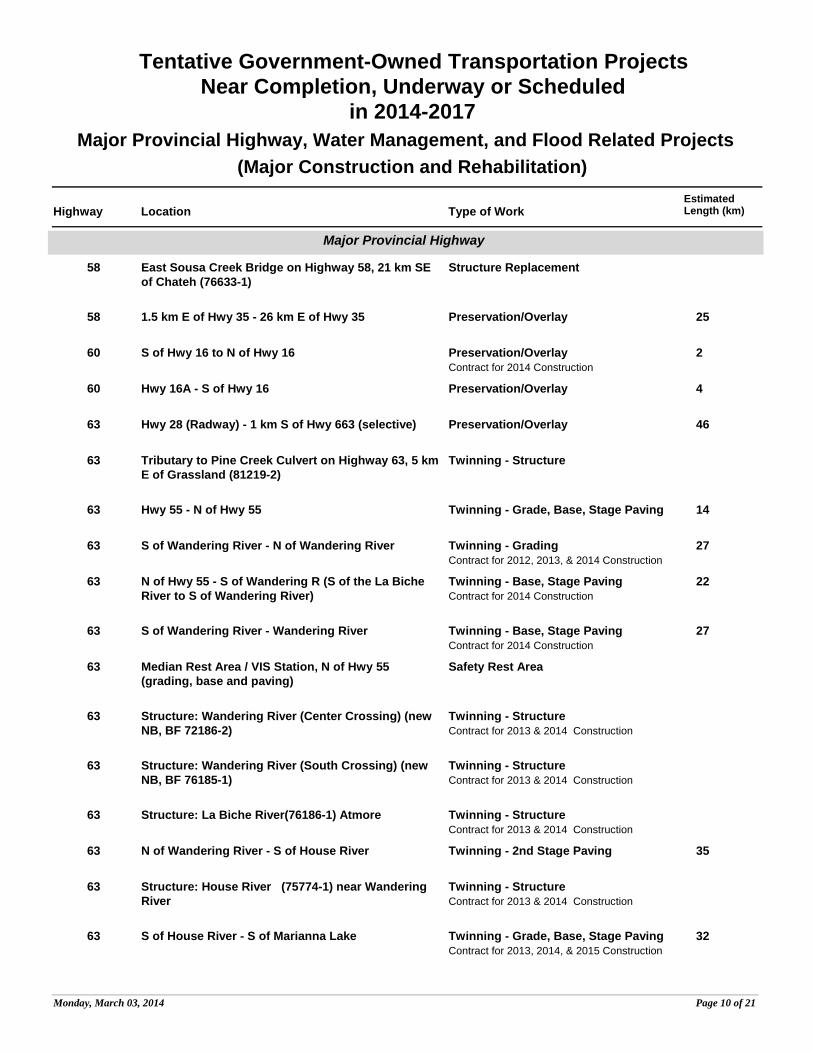
63 Preservation/Overlay 46Hwy 28 (Radway) - 1 km S of Hwy 663 (selective)
63 Twinning - StructureTributary to Pine Creek Culvert on Highway 63, 5 km E of Grassland (81219-2)
63 Twinning - Grade, Base, Stage Paving 14Hwy 55 - N of Hwy 55
63 Twinning - Grading 27Contract for 2012, 2013, & 2014 Construction
S of Wandering River - N of Wandering River
63 Twinning - Base, Stage Paving 22Contract for 2014 Construction
N of Hwy 55 - S of Wandering R (S of the La Biche River to S of Wandering River)
63 Twinning - Base, Stage Paving 27Contract for 2014 Construction
S of Wandering River - Wandering River
63 Safety Rest AreaMedian Rest Area / VIS Station, N of Hwy 55 (grading, base and paving)
63 Twinning - StructureContract for 2013 & 2014 Construction
Structure: Wandering River (Center Crossing) (new NB, BF 72186-2)
63 Twinning - StructureContract for 2013 & 2014 Construction
Structure: Wandering River (South Crossing) (new NB, BF 76185-1)
63 Twinning - StructureContract for 2013 & 2014 Construction
Structure: La Biche River(76186-1) Atmore
63 Twinning - 2nd Stage Paving 35N of Wandering River - S of House River
63 Twinning - StructureContract for 2013 & 2014 Construction
Structure: House River (75774-1) near Wandering River
63 Twinning - Grade, Base, Stage Paving 32Contract for 2013, 2014, & 2015 Construction
S of House River - S of Marianna Lake
Monday, March 03, 2014 Page 10 of 21
Page 13
Highway Location Type of WorkEstimatedLength (km)
Tentative Government-Owned Transportation ProjectsNear Completion, Underway or Scheduled
in 2014-2017Major Provincial Highway, Water Management, and Flood Related Projects
(Major Construction and Rehabilitation)
Major Provincial Highway
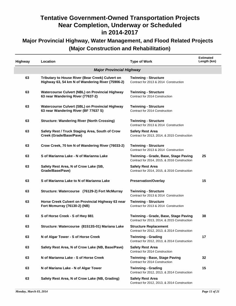
63 Twinning - StructureContract for 2013 & 2014 Construction
Tributary to House River (Bear Creek) Culvert on Highway 63, 54 km N of Wandering River (75906-2)
63 Twinning - StructureContract for 2014 Construction
Watercourse Culvert (NBL) on Provincial Highway 63 near Wandering River (77637-2)
63 Twinning - StructureContract for 2014 Construction
Watercourse Culvert (SBL) on Provincial Highway 63 near Wandering River (BF 77637 S)
63 Twinning - StructureContract for 2013 & 2014 Construction
Structure: Wandering River (North Crossing)
63 Safety Rest AreaContract for 2013, 2014, & 2015 Construction
Safety Rest / Truck Staging Area, South of Crow Creek (Grade/Base/Pave)
63 Twinning - StructureContract for 2013 & 2014 Construction
Crow Creek, 70 km N of Wandering River (76033-2)
63 Twinning - Grade, Base, Stage Paving 25Contract for 2014, 2015, & 2016 Construction
S of Marianna Lake - N of Marianna Lake
63 Safety Rest AreaContract for 2014, 2015, & 2016 Construction
Safety Rest Area, N of Crow Lake (SB, Grade/Base/Pave)
63 Preservation/Overlay 15S of Marianna Lake to N of Marianna Lake
63 Twinning - StructureContract for 2013 & 2014 Construction
Structure: Watercourse (76129-2) Fort McMurray
63 Twinning - StructureContract for 2013 & 2014 Construction
Horse Creek Culvert on Provincial Highway 63 near Fort Mcmurray (76130-2) (NB)
63 Twinning - Grade, Base, Stage Paving 38Contract for 2013, 2014, & 2015 Construction
S of Horse Creek - S of Hwy 881
63 Structure ReplacementContract for 2012, 2013, & 2014 Construction
Structure: Watercourse (81513S-01) Mariana Lake
63 Twinning - Grading 17Contract for 2012, 2013, & 2014 Construction
N of Algar Tower - S of Horse Creek
63 Safety Rest AreaContract for 2014 Construction
Safety Rest Area, N of Crow Lake (NB, Base/Pave)
63 Twinning - Base, Stage Paving 32Contract for 2014 Construction
N of Marianna Lake - S of Horse Creek
63 Twinning - Grading 15Contract for 2012, 2013, & 2014 Construction
N of Mariana Lake - N of Algar Tower
63 Safety Rest AreaContract for 2012, 2013, & 2014 Construction
Safety Rest Area, N of Crow Lake (NB, Grading)
Monday, March 03, 2014 Page 11 of 21
Page 14
Highway Location Type of WorkEstimatedLength (km)
Tentative Government-Owned Transportation ProjectsNear Completion, Underway or Scheduled
in 2014-2017Major Provincial Highway, Water Management, and Flood Related Projects
(Major Construction and Rehabilitation)
Major Provincial Highway
63 Twinning - StructureContract for 2012, 2013, & 2014 Construction
Watercourse Culvert on Provincial Highway 63 near Mariana Lake (81511-2)
63 Preservation/Overlay 24N of Marianna Lake - N of Algar Tower (selective)
63 Safety Rest AreaContract for 2013, 2014, & 2015 Construction
Safety Rest Area, (S of Hwy 881, SB, Grade/Base/Pave)
63 Structure ReplacementContract for 2013 & 2014 Construction
Hangingstone River, (75907S) (Inc 1.3 km Roadwork) 15 km S of Hwy 881 (SBL)
63 Twinning - Grading 12Contract for 2014 Construction
N of Hangingstone River - S of Hwy 881
63 Interchange - Grade, Base, Paving 13Contract for 2013, 2014, & 2015 Construction
Parsons Creek Interchange
63 Preservation/Overlay 22Hwy 686 - Hwy 63X selective
63 2nd Stage Paving20 km N of Hwy 686 - 48 km N of Hwy 686 (selective)
88 Structure ReplacementWatercourse Culvert on Hwy 88, S of Red Earth (86187-1)
88 Structure ReplacementWatercourse Culvert on Provincial Hwy 88 near Red Earth (86234-1)
88 Bridge RehabilitationContract for 2014 Construction
Willow Creek Bridge on Provincial Highway 88 near Red Earth Creek (77319-1)
88 Grading, Base, Stage Paving 48Contract for 2012, 2013, & 2014 Construction
S of Wabasca River (S) - N of Senex Creek
88 Bridge RehabilitationContract for 2014 Construction
Lafond Creek Bridge on Highway 88, 62 km N of Red Earth Creek (77320-1)
88 Bridge Substructure RepairsPeace River Bridge , 8 km NW of Fort Vermilion (74227-1) (slope stabilization)
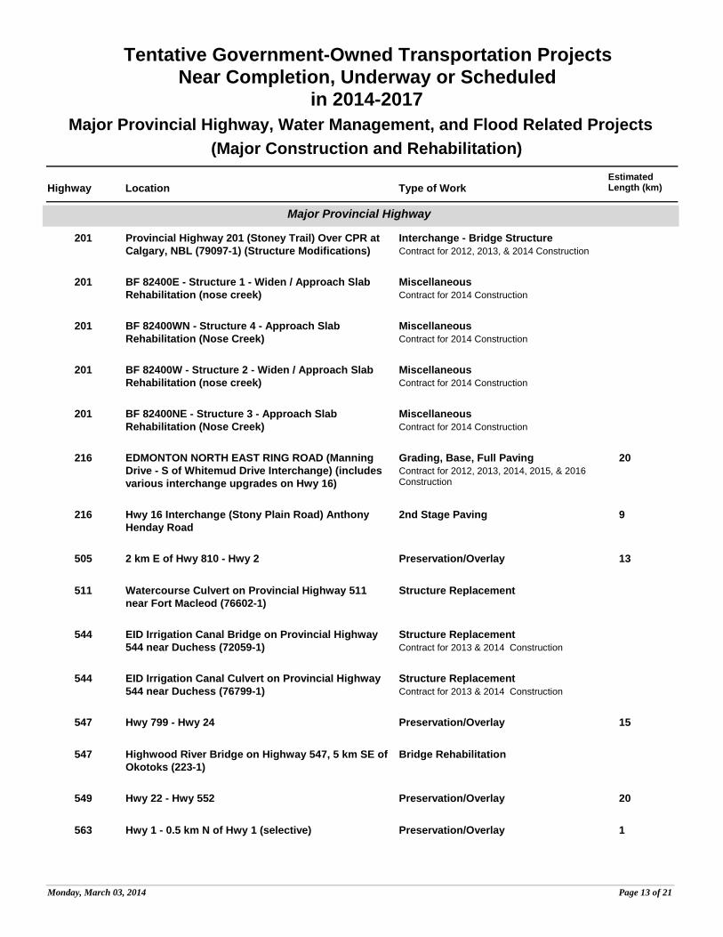
201 Interchange - Bridge StructureContract for 2012, 2013, & 2014 Construction
Provincial Highway 201 (Stoney Trail) Over Nose Hill Drive at Calgary (82402-1)
201 Interchange - Grade, Base, PavingContract for 2012, 2013, & 2014 Construction
Nose Hill Drive Interchange Stony Trail NW
Monday, March 03, 2014 Page 12 of 21
Page 15
Highway Location Type of WorkEstimatedLength (km)
Tentative Government-Owned Transportation ProjectsNear Completion, Underway or Scheduled
in 2014-2017Major Provincial Highway, Water Management, and Flood Related Projects
(Major Construction and Rehabilitation)
Major Provincial Highway
201 Interchange - Bridge StructureContract for 2012, 2013, & 2014 Construction
Provincial Highway 201 (Stoney Trail) Over CPR at Calgary, NBL (79097-1) (Structure Modifications)
201 MiscellaneousContract for 2014 Construction
BF 82400E - Structure 1 - Widen / Approach Slab Rehabilitation (nose creek)
201 MiscellaneousContract for 2014 Construction
BF 82400WN - Structure 4 - Approach Slab Rehabilitation (Nose Creek)
201 MiscellaneousContract for 2014 Construction
BF 82400W - Structure 2 - Widen / Approach Slab Rehabilitation (nose creek)
201 MiscellaneousContract for 2014 Construction
BF 82400NE - Structure 3 - Approach Slab Rehabilitation (Nose Creek)
216 Grading, Base, Full Paving 20Contract for 2012, 2013, 2014, 2015, & 2016 Construction
EDMONTON NORTH EAST RING ROAD (Manning Drive - S of Whitemud Drive Interchange) (includes various interchange upgrades on Hwy 16)
216 2nd Stage Paving 9Hwy 16 Interchange (Stony Plain Road) Anthony Henday Road
505 Preservation/Overlay 132 km E of Hwy 810 - Hwy 2
511 Structure ReplacementWatercourse Culvert on Provincial Highway 511 near Fort Macleod (76602-1)
544 Structure ReplacementContract for 2013 & 2014 Construction
EID Irrigation Canal Bridge on Provincial Highway 544 near Duchess (72059-1)
544 Structure ReplacementContract for 2013 & 2014 Construction
EID Irrigation Canal Culvert on Provincial Highway 544 near Duchess (76799-1)
547 Preservation/Overlay 15Hwy 799 - Hwy 24
547 Bridge RehabilitationHighwood River Bridge on Highway 547, 5 km SE of Okotoks (223-1)
549 Preservation/Overlay 20Hwy 22 - Hwy 552
563 Preservation/Overlay 1Hwy 1 - 0.5 km N of Hwy 1 (selective)
Monday, March 03, 2014 Page 13 of 21
Page 16
Highway Location Type of WorkEstimatedLength (km)
Tentative Government-Owned Transportation ProjectsNear Completion, Underway or Scheduled
in 2014-2017Major Provincial Highway, Water Management, and Flood Related Projects
(Major Construction and Rehabilitation)
Major Provincial Highway
563 Preservation/Overlay 60.5 km N of Hwy 1 - City of Calgary
566 Preservation/Overlay 212 km E of Hwy 2 - Hwy 9
567 Preservation/Overlay 15Hwy 791 - Hwy 9
582 Preservation/Overlay 104 km W of Hwy 2A - 1 km E of Hwy 2
587 Preservation/Overlay 169 km W of Hwy 766 - 7 km E of Hwy 766
590 Preservation/Overlay 81 km E of Hwy 2 - Hwy 791
590 Bridge RehabilitationRed Deer River Bridge on Highway 590, 18 km W of Big Valley (78814-1)
597 Preservation/Overlay 3Hwy 2 - Town of Blackfalds (selective)
601 Structure ReplacementPaintearth Creek Bridge on Provincial Highway 601 near Gadsby (7512-1)
605 Preservation/Overlay 11Hwy 821 - 11 km E of Hwy 821
651 Preservation/Overlay 81 km W of Hwy 777 - 5 km E of Hwy 777
651 Preservation/Overlay 9Hwy 2 - 10 km E of Hwy 803 (selective)
661 Preservation/Overlay 24Hwy 44 - Hwy 2
667 Preservation/Overlay 7Hwy 722 - Hwy 43
670 Structure ReplacementContract for 2014 Construction
Watercourse Bridge on Provincial Highway 670 near Grande Prairie (13767-1)
670 Preservation/Overlay 214 km W of Hwy 43 - 12 km W of Hwy 43
670 Preservation/Overlay 1212 km W of Hwy 43 - Hwy 43
672 Preservation/Overlay 48Hwy 43 - E of Hwy 2
Monday, March 03, 2014 Page 14 of 21
Page 17
Highway Location Type of WorkEstimatedLength (km)
Tentative Government-Owned Transportation ProjectsNear Completion, Underway or Scheduled
in 2014-2017Major Provincial Highway, Water Management, and Flood Related Projects
(Major Construction and Rehabilitation)
Major Provincial Highway
681 Structure ReplacementWatercourse Bridge on Provincial Highway 681 near Blueberry Mountain (76439-1)
682 Structure ReplacementWatercourse Culvert on Provincial Highway 682 near Fairview (8867-1)
685 Preservation/Overlay 22 km W of Hwy 735 - Hwy 735
686 Structure ReplacementWatercourse Culvert on Hwy 686 near Trout Lake (86210-1)
686 Grading, Base, Stage Paving 5Contract for 2014 & 2015 Construction
W of Hwy 63 to Hwy 63
690 Preservation/Overlay 12Hwy 35 - 3 km W of Hwy 743
695 Preservation/Overlay 18W of Hwy 35 - Hwy 35
722 Intersection ImprovementIntersection Improvement at Jct Highway 667
722 Bridge RehabilitationContract for 2014 Construction
Redwillow River Bridge on Highway 722, 18 km S of Beaverlodge (8036-1)
747 Structure ReplacementWatercourse Culvert on Provincial Highway 747 near Sunset House (77835-1)
749 Structure ReplacementDrainage Ditch Culvert on Provincial Highway 749 near High Prairie (70388-1)
752 Preservation/Overlay 1817 km S of Hwy 11A - Hwy 11A
754 Preservation/Overlay 5145 km N of Hwy 88 - 6 km N of Hwy 813 (selective)
756 Preservation/Overlay 5Hwy 11 - Crimson Lake Park Road (PAR 102)
758 Preservation/Overlay 5Hwy 66 - Hwy 22
762 Preservation/Overlay 22Hwy 549 - Hwy 22
769 Structure ReplacementContract for 2014 Construction
Watercourse Bridge on Provincial Highway 769 near Neerlandia (70764-1)
Monday, March 03, 2014 Page 15 of 21
Page 18
Highway Location Type of WorkEstimatedLength (km)
Tentative Government-Owned Transportation ProjectsNear Completion, Underway or Scheduled
in 2014-2017Major Provincial Highway, Water Management, and Flood Related Projects
(Major Construction and Rehabilitation)
Major Provincial Highway
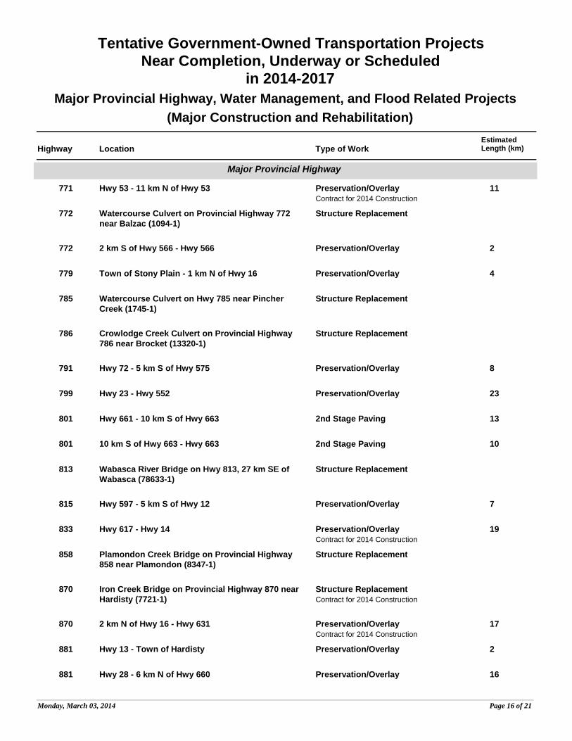
771 Preservation/Overlay 11Contract for 2014 Construction
Hwy 53 - 11 km N of Hwy 53
772 Structure ReplacementWatercourse Culvert on Provincial Highway 772 near Balzac (1094-1)
772 Preservation/Overlay 22 km S of Hwy 566 - Hwy 566
779 Preservation/Overlay 4Town of Stony Plain - 1 km N of Hwy 16
785 Structure ReplacementWatercourse Culvert on Hwy 785 near Pincher Creek (1745-1)
786 Structure ReplacementCrowlodge Creek Culvert on Provincial Highway 786 near Brocket (13320-1)
791 Preservation/Overlay 8Hwy 72 - 5 km S of Hwy 575
799 Preservation/Overlay 23Hwy 23 - Hwy 552
801 2nd Stage Paving 13Hwy 661 - 10 km S of Hwy 663
801 2nd Stage Paving 1010 km S of Hwy 663 - Hwy 663
813 Structure ReplacementWabasca River Bridge on Hwy 813, 27 km SE of Wabasca (78633-1)
815 Preservation/Overlay 7Hwy 597 - 5 km S of Hwy 12
833 Preservation/Overlay 19Contract for 2014 Construction
Hwy 617 - Hwy 14
858 Structure ReplacementPlamondon Creek Bridge on Provincial Highway 858 near Plamondon (8347-1)
870 Structure ReplacementContract for 2014 Construction
Iron Creek Bridge on Provincial Highway 870 near Hardisty (7721-1)
870 Preservation/Overlay 17Contract for 2014 Construction
2 km N of Hwy 16 - Hwy 631
881 Preservation/Overlay 2Hwy 13 - Town of Hardisty
881 Preservation/Overlay 16Hwy 28 - 6 km N of Hwy 660
Monday, March 03, 2014 Page 16 of 21
Page 19
Highway Location Type of WorkEstimatedLength (km)
Tentative Government-Owned Transportation ProjectsNear Completion, Underway or Scheduled
in 2014-2017Major Provincial Highway, Water Management, and Flood Related Projects
(Major Construction and Rehabilitation)
Major Provincial Highway
881 Intersection Improvement 0.01Contract for 2014 Construction
Intersection Improvement at Raven's Nest East Access Road
881 Preservation/Overlay 14Contract for 2013 & 2014 Construction
10 km E of Hwy 63, near Gregoire First Nations
881 Intersection Improvement 0.01Contract for 2014 Construction
Intersection Improvement at AMOCO Road
884 Structure ReplacementBlood Ind Creek Bridge on Provincial Highway 884 near Youngstown (7686-1)
887 Structure ReplacementContract for 2014 Construction
Canal Creek Bridge on Provincial Highway 887 near Orion (7097-1)
899 Bridge RehabilitationRed Deer River Bridge on Highway 899, at NW Boundary of Empress (8132-1)
901 Preservation/Overlay 0.33Hwy 22X - Hwy 22X
986 Structure ReplacementCulvert on Tributary to Cadotte River on Highway 986 NE of Peace River (86227-1)
UAR 56 Preservation/Overlay 2Hwy 45 - Village of Dewberry
UAR 57 Preservation/Overlay 3Hwy 45 - 3 km N of Hwy 45
UAR 82 Preservation/Overlay 3Hwy 44 - 3 km E of Hwy 44
UAR 83 Preservation/Overlay 1Hwy 44 - 1 km E of Hwy 44
UAR 79 Preservation/Overlay 1Hwy 2 - 1 km E of Hwy 2
UAR 160 Preservation/Overlay 3Hwy 2 - 3 km E of Hwy 2
LOCAL ROAD Structure ReplacementIrrigation Canal Culvert on Local Road near Mclennan (86072-1)
Monday, March 03, 2014 Page 17 of 21
Page 20
Highway Location Type of WorkEstimatedLength (km)
Tentative Government-Owned Transportation ProjectsNear Completion, Underway or Scheduled
in 2014-2017Major Provincial Highway, Water Management, and Flood Related Projects
(Major Construction and Rehabilitation)
Water Management
LITTLE BOW RESERVOIR
Water ManagementLittle Bow Reservoir - Stage 2 Main Embankment Rehabilitation
W16804-01 Water ManagementContract for 2013 & 2014 Construction
Chain Lakes Flood Handling Upgrade
W16821-01 Water ManagementCoal Lake Dam - Riparian Outlet - near Gwynne
W16841-04 Water ManagementDickson Dam Controls (53102-1)
W16986-02 Water ManagementLethbridge Northern Headworks Control System (50002-1)
W17064-02 Water ManagementOldman River Dam Controls (50107-2)
BF55117 Water ManagementLesser Slave Lake (55117-1)
BF50051 Water ManagementSt Mary Dam Low Level Outlet Replacement
BF50051 Water ManagementSt Mary Dam Irrigation Shaft Stairwell Replacement (50051-1)
Monday, March 03, 2014 Page 18 of 21
Page 21
Highway Location Type of WorkEstimatedLength (km)
Tentative Government-Owned Transportation ProjectsNear Completion, Underway or Scheduled
in 2014-2017Major Provincial Highway, Water Management, and Flood Related Projects
(Major Construction and Rehabilitation)
Flood Related
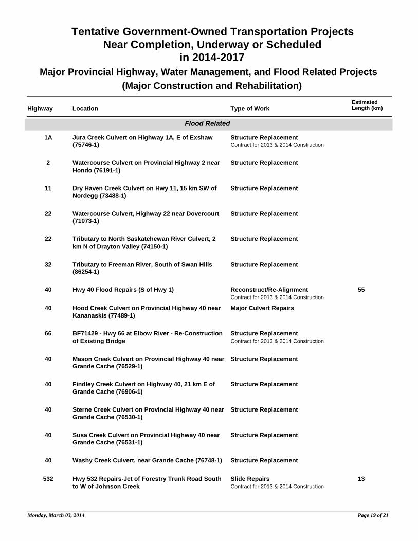
1A Structure ReplacementContract for 2013 & 2014 Construction
Jura Creek Culvert on Highway 1A, E of Exshaw (75746-1)
2 Structure ReplacementWatercourse Culvert on Provincial Highway 2 near Hondo (76191-1)
11 Structure ReplacementDry Haven Creek Culvert on Hwy 11, 15 km SW of Nordegg (73488-1)
22 Structure ReplacementWatercourse Culvert, Highway 22 near Dovercourt (71073-1)
22 Structure ReplacementTributary to North Saskatchewan River Culvert, 2 km N of Drayton Valley (74150-1)
32 Structure ReplacementTributary to Freeman River, South of Swan Hills (86254-1)
40 Reconstruct/Re-Alignment 55Contract for 2013 & 2014 Construction
Hwy 40 Flood Repairs (S of Hwy 1)
40 Major Culvert RepairsHood Creek Culvert on Provincial Highway 40 near Kananaskis (77489-1)
66 Structure ReplacementContract for 2013 & 2014 Construction
BF71429 - Hwy 66 at Elbow River - Re-Construction of Existing Bridge
40 Structure ReplacementMason Creek Culvert on Provincial Highway 40 near Grande Cache (76529-1)
40 Structure ReplacementFindley Creek Culvert on Highway 40, 21 km E of Grande Cache (76906-1)
40 Structure ReplacementSterne Creek Culvert on Provincial Highway 40 near Grande Cache (76530-1)
40 Structure ReplacementSusa Creek Culvert on Provincial Highway 40 near Grande Cache (76531-1)
40 Structure ReplacementWashy Creek Culvert, near Grande Cache (76748-1)
532 Slide Repairs 13Contract for 2013 & 2014 Construction
Hwy 532 Repairs-Jct of Forestry Trunk Road South to W of Johnson Creek
Monday, March 03, 2014 Page 19 of 21
Page 22
Highway Location Type of WorkEstimatedLength (km)
Tentative Government-Owned Transportation ProjectsNear Completion, Underway or Scheduled
in 2014-2017Major Provincial Highway, Water Management, and Flood Related Projects
(Major Construction and Rehabilitation)
Flood Related
541 Reconstruct/Re-Alignment 4Smith Dorrien Spray Trail at Rummel Creek (repair 3 scoured areas)
547 Bridge Substructure RepairsBF1293 Hwy 547 over Bow River (stage 3)
584 Bridge StructureFlood Mitigation Works, James River Bridge on Hwy 584, 10 km NW OF Bearberry
734 Structure ReplacementWigwam Creek Bridge on Provincial Highway 734 near Sundre (77571-1)
734 Structure ReplacementBread Creek Culvert on Provincial Highway 734 near Bearberry (72008-1)
734 Structure ReplacementElk Creek Bridge, near Nordegg (77583-1)
734 Structure ReplacementRadiant Creek Bridge on Hyw 734, 56 km W of Caroline (77581-1)
KANANASKIS PARKS TRAIL
Structure ReplacementEvans-Thomas Bridge on Local Road near Seebe (78899-2)
LOCAL ROAD Reconstruct/Re-Alignment 33Contract for 2013 & 2014 Construction
Forestry Trunk Road South (S of Hwy 541)
LOCAL ROAD Reconstruct/Re-Alignment 26Smith Dorrien Spray Trail, at Rummel Creek (repair scoured area)
LOCAL ROAD Reconstruct/Re-Alignment 23Flood related repairs to Sheep River Road (Hwy 546 extension)
LOCAL ROAD Structure ReplacementPowder Face Trail, Construction for BF 78205 over Jumpingpound Creek
LOCAL ROAD Structure ReplacementPowder Face Trail, Construction for BF 78206-1 over Jumpingpound Creek
LOCAL ROAD Structure ReplacementPowder Face Trail, Construction for BF 78710 over Canyon Creek
LOCAL ROAD Structure ReplacementPowder Face Trail, Construction for BF 79293 over unnamed watercourse near Bragg Creek
Monday, March 03, 2014 Page 20 of 21
Page 23
Highway Location Type of WorkEstimatedLength (km)
Tentative Government-Owned Transportation ProjectsNear Completion, Underway or Scheduled
in 2014-2017Major Provincial Highway, Water Management, and Flood Related Projects
(Major Construction and Rehabilitation)
Flood Related
LOCAL ROAD Major Culvert RepairsPowder Face Trail, Construction for BF 78208 over Jumping Pound Creek
LOCAL ROAD Reconstruct/Re-AlignmentPowder Face Trail, Construction on Various Washouts (10 to 15 locations)
ANTHONY HENDAY
DYKE
Water ManagementContract for 2014 Construction
Repairs to Mountainview -Anthony Henday Dykes (Red Deer River)
LITTLE BOW RIVER CANAL
Water ManagementLittle Bow river Canal Flood Mitigation Works - Construction
WOMEN'S COULEE
Water ManagementFlood Mitigation Work - Construction
Monday, March 03, 2014 Page 21 of 21