4
NOTE GLOBAL REPORT ON INTERNAL DISPLACEMENT 2018 This is a Spotlight taken from IDMC’s 2018 Global Report on Internal Displacement (GRID).

NOTEGLOBAL REPORT ONINTERNALDISPLACEMENT2018
This is a Spotlight taken from IDMC’s 2018 Global Report on Internal Displacement (GRID).
GRID2018
sPoTlighT
indonesia and vanuaTuDisplacement for good reason
The responses of the governments of Indonesia and Vanuatu to volcanic activity in 2017 show how effec-tive early warning systems can be in reducing people’s exposure to hazards They also illustrate the fact that displacement need not always be a negative outcome, in that pre-emptive evacuations save lives and are an effective resilience measure The two countries have unique approaches to disaster risk management, using the Sendai framework and the Sustainable Development Goals to improve their preparedness and responses as a means of reducing loss of life and people’s vulnerability
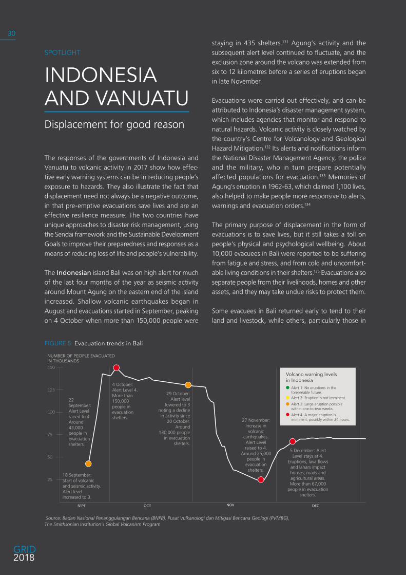
The Indonesian island Bali was on high alert for much of the last four months of the year as seismic activity around Mount Agung on the eastern end of the island increased Shallow volcanic earthquakes began in August and evacuations started in September, peaking on 4 October when more than 150,000 people were
staying in 435 shelters 131 Agung’s activity and the subsequent alert level continued to fluctuate, and the exclusion zone around the volcano was extended from six to 12 kilometres before a series of eruptions began in late November
Evacuations were carried out effectively, and can be attributed to Indonesia’s disaster management system, which includes agencies that monitor and respond to natural hazards Volcanic activity is closely watched by the country’s Centre for Volcanology and Geological Hazard Mitigation 132 Its alerts and notifications inform the National Disaster Management Agency, the police and the military, who in turn prepare potentially affected populations for evacuation 133 Memories of Agung’s eruption in 1962-63, which claimed 1,100 lives, also helped to make people more responsive to alerts, warnings and evacuation orders 134
The primary purpose of displacement in the form of evacuations is to save lives, but it still takes a toll on people’s physical and psychological wellbeing About 10,000 evacuees in Bali were reported to be suffering from fatigue and stress, and from cold and uncomfort-able living conditions in their shelters 135 Evacuations also separate people from their livelihoods, homes and other assets, and they may take undue risks to protect them
Some evacuees in Bali returned early to tend to their land and livestock, while others, particularly those in
figure 5: evacuation trends in Bali
Volcano warning levelsin Indonesia
Alert 1: No eruptions in the foreseeable future. Alert 2: Eruption is not imminent.
Alert 3: Large eruption possible within one-to-two weeks.
Alert 4: A major eruption is imminent, possibly within 24 hours.
150
75
100
125
50
25
NUMBER OF PEOPLE EVACUATEDIN THOUSANDS
SEPT OCT NOV DEC
29 October: Alert level
lowered to 3 noting a decline in activity since
20 October. Around
130,000 people in evacuation
shelters.
27 November: Increase in volcanic
earthquakes. Alert Level raised to 4.
Around 25,000 people in
evacuation shelters.
22 September: Alert Level raised to 4. Around 43,000 people in evacuation shelters.
4 October: Alert Level 4. More than 150,000 people in evacuation shelters.
18 September: Start of volcanic and seismic activity. Alert level increased to 3.
5 December: Alert Level stays at 4.
Eruptions, lava flows and lahars impact houses, roads and agricultural areas. More than 67,000
people in evacuation shelters.
Source: Badan Nasional Penanggulangan Bencana (BNPB), Pusat Vulkanologi dan Mitigasi Bencana Geologi (PVMBG), The Smithsonian Institution’s Global Volcanism Program
30
isolated mountain communities, refused to leave at all 136 In an effort to prevent people on Bali making daily trips in and out of the exclusion zone, the authorities also evacuated as many as 30,000 cows 137
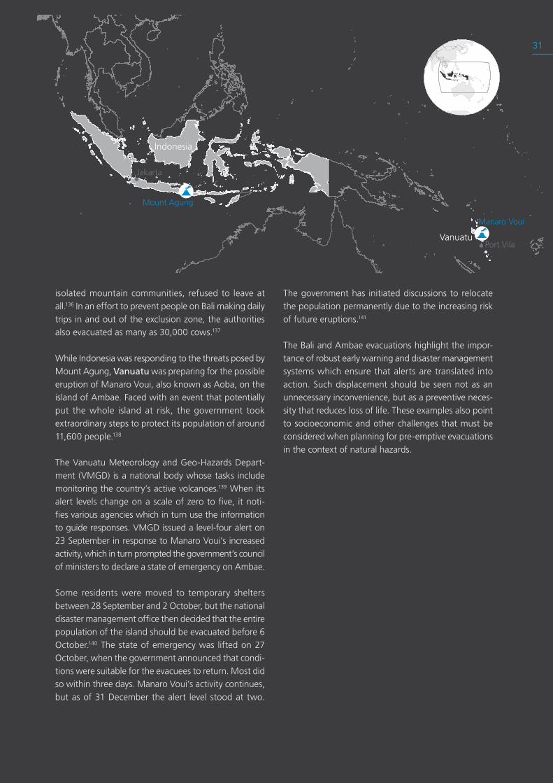
While Indonesia was responding to the threats posed by Mount Agung, Vanuatu was preparing for the possible eruption of Manaro Voui, also known as Aoba, on the island of Ambae Faced with an event that potentially put the whole island at risk, the government took extraordinary steps to protect its population of around 11,600 people 138
The Vanuatu Meteorology and Geo-Hazards Depart-ment (VMGD) is a national body whose tasks include monitoring the country’s active volcanoes 139 When its alert levels change on a scale of zero to five, it noti-fies various agencies which in turn use the information to guide responses VMGD issued a level-four alert on 23 September in response to Manaro Voui’s increased activity, which in turn prompted the government’s council of ministers to declare a state of emergency on Ambae
Some residents were moved to temporary shelters between 28 September and 2 October, but the national disaster management office then decided that the entire population of the island should be evacuated before 6 October 140 The state of emergency was lifted on 27 October, when the government announced that condi-tions were suitable for the evacuees to return Most did so within three days Manaro Voui’s activity continues, but as of 31 December the alert level stood at two
The government has initiated discussions to relocate the population permanently due to the increasing risk of future eruptions 141
The Bali and Ambae evacuations highlight the impor-tance of robust early warning and disaster management systems which ensure that alerts are translated into action Such displacement should be seen not as an unnecessary inconvenience, but as a preventive neces-sity that reduces loss of life These examples also point to socioeconomic and other challenges that must be considered when planning for pre-emptive evacuations in the context of natural hazards
Port Vila
Jakarta
Mount Agung
Manaro Voui
Indonesia
Vanuatu
31
| Footnotes
131. Global Volcanism Program, “Report on Agung (Indonesia),” in Weekly Volcanic Activity Report, 13 September-19 Sep-tember 2017, ed. Sennert, S K (Smithsonian Institution and US Geological Survey, 2017), https://goo.gl/ZNPcoq.
132. Pusat Vulkanologi dan Mitigasi Bencana Geologi, “Badan Geologi,” accessed 20 March 2018, https://goo.gl/jKDjT8.
133. Badan Nasional Penanggulangan Bencana, “BNPB,” Badan Nasional Penanggulangan Bencana, accessed 21 March 2018, https://goo.gl/aBcXH5.
134. Will Kirby, “‘Lava Destroyed EVERYTHING’ Survivors of 1963 Mt Agung Eruption Recall Devastation of Bali,” Express.co.uk, 27 November 2017, https://goo.gl/1FXuBV.
135. Ibid.
136. Nicola Smith and Simon Roughneen, “Some Residents ‘Refus-ing to Evacuate’ from Bali’s Mt Agung Volcano Danger Zone, as Nervous Tourists Await News,” The Telegraph, September 2017, https://goo.gl/U7v1be.
137. Agence France-Presse, “Bali Volcano Threat Puts Volunteers in Race to Save Cows and Monkeys,” The Guardian, 30 September 2017, https://goo.gl/rA4vuE.
138. Chris Firth, “Ambae Volcano’s Crater Lakes Make It a Seri-ous Threat to Vanuatu,” The Conversation (blog), 2017, https://goo.gl/86LQzL.
139. Vanuatu Meteorology & Geo-Harzards Department, “Home,” 2018, https://goo.gl/KHF9oM.
140. Reuters, “Locals Evacuate Ambae Island as Vanuatu Vol-cano Threatens to Erupt – Video,” The Guardian, 2 October 2017, https://goo.gl/sNQUTo.
141. Roy, Eleanor Ainge. “Island of No Return: Vanuatu Evacu-ates Entire Population of Volcanic Ambae.” The Guardian, 19 April 2018. https://goo.gl/P4hmSS.
124
GRID2018


