133
2021 MOUNTAIN LAKES GUIDE Silver Lake ABSAROKA - BEARTOOTH & CRAZY MOUNTAINS

2021 MOUNTAIN LAKES GUIDE
Silver Lake
ABSAROKA - BEARTOOTH&
CRAZY MOUNTAINS

Fellow Angler:
This booklet is intended to pass on information collected over many years about the fishery of the
Absaroka-Beartooth high country lakes. Since Pat Marcuson began surveying these lakes in 1967, many individuals
have hefted a heavy pack and worked the high country for Fish, Wildlife and Parks. They have brought back the raw
data and personal observations necessary to formulate management schemes for the 300+ lakes in this area
containing fish. While the information presented here is not intended as a guide for hiking/camping or fishing
techniques, it should help wilderness users to better plan their trips according to individual preferences and abilities.
Fish species present in the Absaroka-Beartooth lakes include Yellowstone cutthroat trout, brook trout, rainbow trout,
golden trout, arctic grayling, and variations of cutthroat/rainbow/golden trout hybrids. These lake fisheries generally
fall into two categories: self-sustaining and stocked. Self-sustaining lakes have enough spawning habitat to allow
fish to restock themselves year after year. These often contain so many fish that while fishing can be fast, the
average fish size will be small. The average size and number of fish present change very little from year to year in
most of these lakes.
Lakes without spawning potential must be planted regularly to sustain a fishery. Standard stocking in the Beartooths
is 50-100 Yellowstone cutthroat trout fingerlings per acre every eight years. Special situations may call for different
species, numbers, or frequency of plants. For instance, lakes with heavy fishing pressure tend to be stocked more
often and at higher densities. Grayling and golden trout are stocked to provide unique fishing opportunities and to
help conserve populations of these rare fish. In the first few years after planting, many small fish will be found in a
lake. With each passing year, fewer but larger fish will remain until all the fish age out and are gone, generally in 7-9
years. An angler can thus use the stocking history in this guide to predict what sizes and numbers of fish a given
lake might currently contain.
Every year, Fish, Wildlife and Parks survey crews sample 30+ lakes out of the 300+ lakes containing fish. Results of
past sampling efforts found in this report can be informative if looked at in the context of the stocking cycle for each
lake. While this data will not provide up-to-theminute information for anglers, it is sufficient to allow a good guess
about what may be present at any given time. Still, these wilderness waters can hold surprises. Additional water
body and raw data can be found on the FWP website under Fish MT. I would appreciate any information you gather
while on your trip (such as species, numbers, and accurate lengths).
For more information contact:
Ben Bailey
Montana Fish, Wildlife and Parks
Red Lodge, MT
406-698-9574
2

Tips For Using This Guide
Latitude/Longitude: These are taken at the middle of the lakes and are used for stocking purposes.
Marcusons Code = Code number of lake by drainage e.g., Rock Creek #60, East Rosebud #5, etc.
Crazy Mountain lake information can be found at the very end of this booklet.
As this guide will be updated yearly, the typeface has been much reduced and it is available online at
(http://fwp.mt.gov/r5/mountainlakes) to keep costs down. I trust the information contained here will be worth the
extra eye strain or price of a magnifying glass to the user.
While this guide deals with mountain lakes, an angler would be wise not to overlook the many streams of the
Beartooths.
Special thanks go to all Montana Fish, Wildlife & Parks Mountain Lake crews that have worked on the Mountain
Lakes surveys, as well as those dedicated FWP employees who worked to keep the Mountain Lakes Guide
updated throughout the years.
Enjoy and respect the high country. Good Fishing!
3

Table of Contents
12Fish Species Opportunities By Drainage
. . . . . . . . . . . . . . . . . . . . . . . . . . . . . . . . . . . . . . . . . . . . . . . . . . . . . . . . . 12Boulder Drainage (Beartooth Range)
. . . . . . . . . . . . . . . . . . . . . . . . . . . . . . . . . . . . . . . . . . . . . . . . . . . . . . . 12Clarks Fork Drainage (Beartooth Range)
. . . . . . . . . . . . . . . . . . . . . . . . . . . . . . . . . . . . . . . . . . . . . . . . . . . . . . 12East Rosebud Drainage (Beartooth Range)
. . . . . . . . . . . . . . . . . . . . . . . . . . . . . . . . . . . . . . . . . . . . . . . . . . . . . . . 12Rock Creek Drainage (Beartooth Range)
. . . . . . . . . . . . . . . . . . . . . . . . . . . . . . . . . . . . . . . . . . . . . . . . . . . . . . 12Slough Creek Drainage (Beartooth Range)
. . . . . . . . . . . . . . . . . . . . . . . . . . . . . . . . . . . . . . . . . . . . . . . . . . . . . . . . 13Stillwater Drainage (Beartooth Range)
. . . . . . . . . . . . . . . . . . . . . . . . . . . . . . . . . . . . . . . . . . . . . . . . . . . . . 13West Rosebud Drainage (Beartooth Range)
. . . . . . . . . . . . . . . . . . . . . . . . . . . . . . . . . . . . . . . . . . . . . . . . . . . . . . 13Big Timber Creek Drainage (Crazy Range)
. . . . . . . . . . . . . . . . . . . . . . . . . . . . . . . . . . . . . . . . . . . . . . . . . . . . . 13Cottonwood Creek Drainage (Crazy Range)
. . . . . . . . . . . . . . . . . . . . . . . . . . . . . . . . . . . . . . . . . . . . . . . . . . . . . . . . . 13Rock Creek Drainage (Crazy Range)
. . . . . . . . . . . . . . . . . . . . . . . . . . . . . . . . . . . . . . . . . . . . . . . . . . . . . . . . 13Swamp Creek Drainage (Crazy Range)
. . . . . . . . . . . . . . . . . . . . . . . . . . . . . . . . . . . . . . . . . . . . . . . . . . . . . 13Sweet Grass Creek Drainage (Crazy Range)
14Beartooth Mountain Range
. . . . . . . . . . . . . . . . . . . . . . . . . . . . . . . . . . . . . . . . . . . . . . . . . . . . . . . . . . . . . . . . . . . . . . 14Boulder Drainage
. . . . . . . . . . . . . . . . . . . . . . . . . . . . . . . . . . . . . . . . . . . . . . . . . . . . . . . . . . . . . . . . . . . . . . 14Alpine Lake
. . . . . . . . . . . . . . . . . . . . . . . . . . . . . . . . . . . . . . . . . . . . . . . . . . . . . . . . . . . . . . . . . . . . . . 14Beaver Pond
. . . . . . . . . . . . . . . . . . . . . . . . . . . . . . . . . . . . . . . . . . . . . . . . . . . . . . . . . . . . . . . . . . . . . 14Blacktail Lake
. . . . . . . . . . . . . . . . . . . . . . . . . . . . . . . . . . . . . . . . . . . . . . . . . . . . . . . . . . . . . . . . . . . . . . . 15Blue Lake
. . . . . . . . . . . . . . . . . . . . . . . . . . . . . . . . . . . . . . . . . . . . . . . . . . . . . . . . . . . . . . . . 15Bramble Creek Lake 38
. . . . . . . . . . . . . . . . . . . . . . . . . . . . . . . . . . . . . . . . . . . . . . . . . . . . . . . . . 15Bramble Creek Lake 39 (Bramble #1)
. . . . . . . . . . . . . . . . . . . . . . . . . . . . . . . . . . . . . . . . . . . . . . . . . . . . . . . . . . . . 16Bramble Lake #41 (Bramble #3)
. . . . . . . . . . . . . . . . . . . . . . . . . . . . . . . . . . . . . . . . . . . . . . . . . . . . . . . . . . . . . . . . . . . . . . 16Bridge Lake
. . . . . . . . . . . . . . . . . . . . . . . . . . . . . . . . . . . . . . . . . . . . . . . . . . . . . . . . . . . . . . . . . . . 16Burnt Gulch Lake
. . . . . . . . . . . . . . . . . . . . . . . . . . . . . . . . . . . . . . . . . . . . . . . . . . . . . . . . . . . . . . . . . . . . . . . 17Camp Lake
. . . . . . . . . . . . . . . . . . . . . . . . . . . . . . . . . . . . . . . . . . . . . . . . . . . . . . . . . . . . . . . . . . . . 17Chickadee Lake
. . . . . . . . . . . . . . . . . . . . . . . . . . . . . . . . . . . . . . . . . . . . . . . . . . . . . . . . . . . . . . . . . . . . . . . 17Davis Lake
. . . . . . . . . . . . . . . . . . . . . . . . . . . . . . . . . . . . . . . . . . . . . . . . . . . . . . . . . . . . . . . . . . . . . . . . 18Elk Lake
. . . . . . . . . . . . . . . . . . . . . . . . . . . . . . . . . . . . . . . . . . . . . . . . . . . . . . . . . . . . . . . . . . . . . . . . 18Fish Lake
. . . . . . . . . . . . . . . . . . . . . . . . . . . . . . . . . . . . . . . . . . . . . . . . . . . . . . . . . . . . 19Great Falls Creek Lake, Lower
. . . . . . . . . . . . . . . . . . . . . . . . . . . . . . . . . . . . . . . . . . . . . . . . . . . . . . . . . . . . . . . . . . . . 19Horseshoe Lake
. . . . . . . . . . . . . . . . . . . . . . . . . . . . . . . . . . . . . . . . . . . . . . . . . . . . . . . . . . . . . . . . . . . . . . . 19Icicle Lake
. . . . . . . . . . . . . . . . . . . . . . . . . . . . . . . . . . . . . . . . . . . . . . . . . . . . . . . . . . . 20Kaufman Lake (Falls Creek Lake)
. . . . . . . . . . . . . . . . . . . . . . . . . . . . . . . . . . . . . . . . . . . . . . . . . . . . . . . . . . . . . . . . . . . . 20Lake Columbine
. . . . . . . . . . . . . . . . . . . . . . . . . . . . . . . . . . . . . . . . . . . . . . . . . . . . . . . . . . . . . . . . . . . . . 20Lake Mcknight
. . . . . . . . . . . . . . . . . . . . . . . . . . . . . . . . . . . . . . . . . . . . . . . . . . . . . . . . . . . . . . . . . . . . . . . 21Mirror Lake
. . . . . . . . . . . . . . . . . . . . . . . . . . . . . . . . . . . . . . . . . . . . . . . . . . . . . . . . . . . . . . . . . . 21Narrow Escape Lake
. . . . . . . . . . . . . . . . . . . . . . . . . . . . . . . . . . . . . . . . . . . . . . . . . . . . . . . . . . . . . . . . . . . . . 21Prospect Lake
. . . . . . . . . . . . . . . . . . . . . . . . . . . . . . . . . . . . . . . . . . . . . . . . . . . . . . . . . . . . . . . . . . . 22Rainbow Lake #2
. . . . . . . . . . . . . . . . . . . . . . . . . . . . . . . . . . . . . . . . . . . . . . . . . . . . . . . . . . . . . . . . . . . 22Rainbow Lake #3
. . . . . . . . . . . . . . . . . . . . . . . . . . . . . . . . . . . . . . . . . . . . . . . . . . . . . . . . . . . . . . . . . . . 23Rainbow Lake #4
. . . . . . . . . . . . . . . . . . . . . . . . . . . . . . . . . . . . . . . . . . . . . . . . . . . . . . . . . . . . . . . . . . . . 23Rainbow Lake 5
. . . . . . . . . . . . . . . . . . . . . . . . . . . . . . . . . . . . . . . . . . . . . . . . . . . . . . . . . . . . . . . . . . . . 24Rainbow Lake 64

. . . . . . . . . . . . . . . . . . . . . . . . . . . . . . . . . . . . . . . . . . . . . . . . . . . . . . . . . . . . . . . . . . . . 24Rainbow Lake 7
. . . . . . . . . . . . . . . . . . . . . . . . . . . . . . . . . . . . . . . . . . . . . . . . . . . . . . . . . . . . . . . . . . . . . . . 25Silver Lake
. . . . . . . . . . . . . . . . . . . . . . . . . . . . . . . . . . . . . . . . . . . . . . . . . . . . . . . . . . . . . . . . . . . . 25Speculator Lake
. . . . . . . . . . . . . . . . . . . . . . . . . . . . . . . . . . . . . . . . . . . . . . . . . . . . . . . . . . . . . . . . . . . . . 26Squeeze Lake
. . . . . . . . . . . . . . . . . . . . . . . . . . . . . . . . . . . . . . . . . . . . . . . . . . . . . . . . . . . . . . . . . . . . . . . 26Trout Lake
. . . . . . . . . . . . . . . . . . . . . . . . . . . . . . . . . . . . . . . . . . . . . . . . . . . . . . . . . . . . . . . . . 26Upper Mcknight Lake
. . . . . . . . . . . . . . . . . . . . . . . . . . . . . . . . . . . . . . . . . . . . . . . . . . . . . . . . . . . . . . . . . . . 27Weasel Lake #48
. . . . . . . . . . . . . . . . . . . . . . . . . . . . . . . . . . . . . . . . . . . . . . . . . . . . . . . . . . . . . . . . . . . 27Weasel Lake #51
. . . . . . . . . . . . . . . . . . . . . . . . . . . . . . . . . . . . . . . . . . . . . . . . . . . . . . . . . . . . . . . . . . . 27West Boulder Lake
. . . . . . . . . . . . . . . . . . . . . . . . . . . . . . . . . . . . . . . . . . . . . . . . . . . . . . . . . . . . . . . . . . . . 28Clarks Fork Drainage
. . . . . . . . . . . . . . . . . . . . . . . . . . . . . . . . . . . . . . . . . . . . . . . . . . . . . . . . . . . . . . . . . . . . 28Abandoned Lake
. . . . . . . . . . . . . . . . . . . . . . . . . . . . . . . . . . . . . . . . . . . . . . . . . . . . . . . . . . . . . . . . . . . . . . 28Albino Lake
. . . . . . . . . . . . . . . . . . . . . . . . . . . . . . . . . . . . . . . . . . . . . . . . . . . . . . . . . . . . . . . . . . . . . . . . 28Alp Lake
. . . . . . . . . . . . . . . . . . . . . . . . . . . . . . . . . . . . . . . . . . . . . . . . . . . . . . . . . . . . . . . . . . . . . . 29Anchor Lake
. . . . . . . . . . . . . . . . . . . . . . . . . . . . . . . . . . . . . . . . . . . . . . . . . . . . . . . . . . . . . . . . . . . . . 29Aquarius Lake
. . . . . . . . . . . . . . . . . . . . . . . . . . . . . . . . . . . . . . . . . . . . . . . . . . . . . . . . . . . . . . . . . . . . . . . 29Astral Lake
. . . . . . . . . . . . . . . . . . . . . . . . . . . . . . . . . . . . . . . . . . . . . . . . . . . . . . . . . . . . . . . . . . . . 30Bald Knob Lake
. . . . . . . . . . . . . . . . . . . . . . . . . . . . . . . . . . . . . . . . . . . . . . . . . . . . . . . . . . . . . . . 30Basin Lake (Picasso Lake)
. . . . . . . . . . . . . . . . . . . . . . . . . . . . . . . . . . . . . . . . . . . . . . . . . . . . . . . . . . . . . . . . . . . . . 30Big Butte Lake
. . . . . . . . . . . . . . . . . . . . . . . . . . . . . . . . . . . . . . . . . . . . . . . . . . . . . . . . . . . . . . . . . . . . 31Big Moose Lake
. . . . . . . . . . . . . . . . . . . . . . . . . . . . . . . . . . . . . . . . . . . . . . . . . . . . . . . . . . . . . . . . . . . . . . . . 31Bob Lake
. . . . . . . . . . . . . . . . . . . . . . . . . . . . . . . . . . . . . . . . . . . . . . . . . . . . . . . . . . . . . . . . . . . . 31Broadwater Lake
. . . . . . . . . . . . . . . . . . . . . . . . . . . . . . . . . . . . . . . . . . . . . . . . . . . . . . . . . . . . . . . . . . 32Broadwater Meadow
. . . . . . . . . . . . . . . . . . . . . . . . . . . . . . . . . . . . . . . . . . . . . . . . . . . . . . . . . . . . . . . . . . . 32Burnt Bacon Lake
. . . . . . . . . . . . . . . . . . . . . . . . . . . . . . . . . . . . . . . . . . . . . . . . . . . . . . . . . . . . . . . . . . . . . . 32Canyon Lake
. . . . . . . . . . . . . . . . . . . . . . . . . . . . . . . . . . . . . . . . . . . . . . . . . . . . . . . . . . . . . . . 33Castle Lake (Queer Lake)
. . . . . . . . . . . . . . . . . . . . . . . . . . . . . . . . . . . . . . . . . . . . . . . . . . . . . . . . . . . . . . . . . . . . . . . . 33Cliff Lake
. . . . . . . . . . . . . . . . . . . . . . . . . . . . . . . . . . . . . . . . . . . . . . . . . . . . . . . . . . . . . . . . . . 33Cloverleaf Lake 215
. . . . . . . . . . . . . . . . . . . . . . . . . . . . . . . . . . . . . . . . . . . . . . . . . . . . . . . . . . . . . . . . . . 34Cloverleaf Lake 216
. . . . . . . . . . . . . . . . . . . . . . . . . . . . . . . . . . . . . . . . . . . . . . . . . . . . . . . . . . . . . . . . . . 34Cloverleaf Lake 217
. . . . . . . . . . . . . . . . . . . . . . . . . . . . . . . . . . . . . . . . . . . . . . . . . . . . . . . . . . . . . . . . . . 34Cloverleaf Lake 223
. . . . . . . . . . . . . . . . . . . . . . . . . . . . . . . . . . . . . . . . . . . . . . . . . . . . . . . . . . . . . . . . . . . . 35Companion Lake
. . . . . . . . . . . . . . . . . . . . . . . . . . . . . . . . . . . . . . . . . . . . . . . . . . . . . . . . . . . . . . . . . . . . . 35Copeland Lake
. . . . . . . . . . . . . . . . . . . . . . . . . . . . . . . . . . . . . . . . . . . . . . . . . . . . . . . . . . . . . . . . . . . . . . 35Corner Lake
. . . . . . . . . . . . . . . . . . . . . . . . . . . . . . . . . . . . . . . . . . . . . . . . . . . . . . . . . . . . . . . . . . . . . . 36Cradle Lake
. . . . . . . . . . . . . . . . . . . . . . . . . . . . . . . . . . . . . . . . . . . . . . . . . . . . . . . . . . . . . . . . . . . . . . 36Crystal Lake
. . . . . . . . . . . . . . . . . . . . . . . . . . . . . . . . . . . . . . . . . . . . . . . . . . . . . . . . . . . . . . . . . . . . . . . . 36Curl Lake
. . . . . . . . . . . . . . . . . . . . . . . . . . . . . . . . . . . . . . . . . . . . . . . . . . . . . . . . . . . . . . . . . . . . 37Desolation Lake
. . . . . . . . . . . . . . . . . . . . . . . . . . . . . . . . . . . . . . . . . . . . . . . . . . . . . . . . . . . . . . . 37Diamond Lake (Cliff Lake)
. . . . . . . . . . . . . . . . . . . . . . . . . . . . . . . . . . . . . . . . . . . . . . . . . . . . . . . . . . . . . . . . . . . . . . . 37Dick Lake
. . . . . . . . . . . . . . . . . . . . . . . . . . . . . . . . . . . . . . . . . . . . . . . . . . . . . . . . . . . . . . . . . . . . . . . 38Dollar Lake
. . . . . . . . . . . . . . . . . . . . . . . . . . . . . . . . . . . . . . . . . . . . . . . . . . . . . . . . . . . . . . . . . . . . . 38Donelson Lake
. . . . . . . . . . . . . . . . . . . . . . . . . . . . . . . . . . . . . . . . . . . . . . . . . . . . . . . . . . . . . . . . . . . . . . 38Estelle Lake
. . . . . . . . . . . . . . . . . . . . . . . . . . . . . . . . . . . . . . . . . . . . . . . . . . . . . . . . . . . . . . . . . . . . . . 39Farley Lake
. . . . . . . . . . . . . . . . . . . . . . . . . . . . . . . . . . . . . . . . . . . . . . . . . . . . . . . . . . . . . . 39Finger Lake (Hunger Lake)
. . . . . . . . . . . . . . . . . . . . . . . . . . . . . . . . . . . . . . . . . . . . . . . . . . . . . 39Fizzle Lake (Dead Horse Lake, Windy Lake)
. . . . . . . . . . . . . . . . . . . . . . . . . . . . . . . . . . . . . . . . . . . . . . . . . . . . . . . . . . . . . . . . . . . . . 40Flat Rock Lake
. . . . . . . . . . . . . . . . . . . . . . . . . . . . . . . . . . . . . . . . . . . . . . . . . . . . . . . . . . . . . . . . . . . . . . . . 40Fox Lake
5

. . . . . . . . . . . . . . . . . . . . . . . . . . . . . . . . . . . . . . . . . . . . . . . . . . . . . . . . . . . . . . . 40Fritter Lake (Hipshot Lake)
. . . . . . . . . . . . . . . . . . . . . . . . . . . . . . . . . . . . . . . . . . . . . . . . . . . . . . . . . . . . . 41Fulcrum Lake (Mermaid Lake)
. . . . . . . . . . . . . . . . . . . . . . . . . . . . . . . . . . . . . . . . . . . . . . . . . . . . . . . . . . . . . . . . . . . . . . 41Gallery Lake
. . . . . . . . . . . . . . . . . . . . . . . . . . . . . . . . . . . . . . . . . . . . . . . . . . . . . . . . . . . . . . . . . . . . . . 41Golden Lake
. . . . . . . . . . . . . . . . . . . . . . . . . . . . . . . . . . . . . . . . . . . . . . . . . . . . . . . . . . . . . . . . . . . . . . 42Granite Lake
. . . . . . . . . . . . . . . . . . . . . . . . . . . . . . . . . . . . . . . . . . . . . . . . . . . . . . . . . . . . . . . . . . . . . . 42Green Lake
. . . . . . . . . . . . . . . . . . . . . . . . . . . . . . . . . . . . . . . . . . . . . . . . . . . . . . . . . . . . . . . . . . . . . . 42Green Lake
. . . . . . . . . . . . . . . . . . . . . . . . . . . . . . . . . . . . . . . . . . . . . . . . . . . . . . . . . . . . . . . . . . . . . . . . 43Gus Lake
. . . . . . . . . . . . . . . . . . . . . . . . . . . . . . . . . . . . . . . . . . . . . . . . . . . . . . . . . . . . . . . . . . . . . . . 43Heidi Lake
. . . . . . . . . . . . . . . . . . . . . . . . . . . . . . . . . . . . . . . . . . . . . . . . . . . . . . . . . . . . . . . . . . . . . . 43Hidden Lake
. . . . . . . . . . . . . . . . . . . . . . . . . . . . . . . . . . . . . . . . . . . . . . . . . . . . . . . . . . . . . . . . . . . 44Indian Knife Lake
. . . . . . . . . . . . . . . . . . . . . . . . . . . . . . . . . . . . . . . . . . . . . . . . . . . . . . . . . . . . . . . . . . . . . . 44Jasper Lake
. . . . . . . . . . . . . . . . . . . . . . . . . . . . . . . . . . . . . . . . . . . . . . . . . . . . . . . . . . . . . . . . . . . . . . 44Jorden Lake
. . . . . . . . . . . . . . . . . . . . . . . . . . . . . . . . . . . . . . . . . . . . . . . . . . . . . . . . . . . . . . . . . . . . . . 45Kersey Lake
. . . . . . . . . . . . . . . . . . . . . . . . . . . . . . . . . . . . . . . . . . . . . . . . . . . . . . . . . . . . . . . . . . . . . . 45Kidney Lake
. . . . . . . . . . . . . . . . . . . . . . . . . . . . . . . . . . . . . . . . . . . . . . . . . . . . . . . . . . . . . . . . . . . 45Lady Of The Lake
. . . . . . . . . . . . . . . . . . . . . . . . . . . . . . . . . . . . . . . . . . . . . . . . . . . . . . . . . . . . . . . . . . . . . . 46Lake Elaine
. . . . . . . . . . . . . . . . . . . . . . . . . . . . . . . . . . . . . . . . . . . . . . . . . . . . . . . . . . . . . . . . . . 46Lake Of The Clouds
. . . . . . . . . . . . . . . . . . . . . . . . . . . . . . . . . . . . . . . . . . . . . . . . . . . . . . . . . . . . . . . . . . 46Lake Of The Winds
. . . . . . . . . . . . . . . . . . . . . . . . . . . . . . . . . . . . . . . . . . . . . . . . . . . . . . . . . 47Leaky Raft Lake (Unnamed Lake 33)
. . . . . . . . . . . . . . . . . . . . . . . . . . . . . . . . . . . . . . . . . . . . . . . . . . . . . . . . . . . . . . . . . . . . . . 47Lennon Lake
. . . . . . . . . . . . . . . . . . . . . . . . . . . . . . . . . . . . . . . . . . . . . . . . . . . . . . . . . . . . . . . . . . . . . . . 47Lillis Lake
. . . . . . . . . . . . . . . . . . . . . . . . . . . . . . . . . . . . . . . . . . . . . . . . . . . . . . . . . . . . . . . . . . . . . . . . 48Line Lake
. . . . . . . . . . . . . . . . . . . . . . . . . . . . . . . . . . . . . . . . . . . . . . . . . . . . . . . . . . . . . . . . . . . . 48Little Green Lake
. . . . . . . . . . . . . . . . . . . . . . . . . . . . . . . . . . . . . . . . . . . . . . . . . . . . . . . . . 48Little Washtub Lake (Washtub Lake)
. . . . . . . . . . . . . . . . . . . . . . . . . . . . . . . . . . . . . . . . . . . . . . . . . . . . . . . . . . . . . . . . . . . . . 49Lone Elk Lake
. . . . . . . . . . . . . . . . . . . . . . . . . . . . . . . . . . . . . . . . . . . . . . . . . . . . . . . . . . . . . . . . . . . . 49Lonesome Lake
. . . . . . . . . . . . . . . . . . . . . . . . . . . . . . . . . . . . . . . . . . . . . . . . . . . . . . . . . . . . . . . . 49Long Lake (Lone Lake)
. . . . . . . . . . . . . . . . . . . . . . . . . . . . . . . . . . . . . . . . . . . . . . . . . . 50Looking Glass Lake (Glass Lake, Stephanie Lake)
. . . . . . . . . . . . . . . . . . . . . . . . . . . . . . . . . . . . . . . . . . . . . . . . . . . . . . . . . . . . . . . . . . . . 50Lower Aero Lake
. . . . . . . . . . . . . . . . . . . . . . . . . . . . . . . . . . . . . . . . . . . . . . . . . . . . . . . . . . . . . . . . . . . . . 51Margaret Lake
. . . . . . . . . . . . . . . . . . . . . . . . . . . . . . . . . . . . . . . . . . . . . . . . . . . . . . . . . . . . . . . . . . . . . 51Mariane Lake
. . . . . . . . . . . . . . . . . . . . . . . . . . . . . . . . . . . . . . . . . . . . . . . . . . . . . . . . . . . . . . . . . . . . . . 51Marsh Lake
. . . . . . . . . . . . . . . . . . . . . . . . . . . . . . . . . . . . . . . . . . . . . . . . . . . . . . . . . . . . . . . . . . . . . . 52Martin Lake
. . . . . . . . . . . . . . . . . . . . . . . . . . . . . . . . . . . . . . . . . . . . . . . . . . . . . . . . . . . . . . . . . . . . . . 52Maryott Lake
. . . . . . . . . . . . . . . . . . . . . . . . . . . . . . . . . . . . . . . . . . . . . . . . . . . . . . . . . . . . . . . . . . . . . . 52Melody Lake
. . . . . . . . . . . . . . . . . . . . . . . . . . . . . . . . . . . . . . . . . . . . . . . . . . . . . . . . . . . 53Midnight Lake (Red Storm Lake)
. . . . . . . . . . . . . . . . . . . . . . . . . . . . . . . . . . . . . . . . . . . . . . . . . . . . . . . . . . . . . . . . . . . . . 53Moccasin Lake
. . . . . . . . . . . . . . . . . . . . . . . . . . . . . . . . . . . . . . . . . . . . . . . . . . . . . . . . . . . . . . . . . . . . . 53Mosquito Lake
. . . . . . . . . . . . . . . . . . . . . . . . . . . . . . . . . . . . . . . . . . . . . . . . . . . . 54North Hidden Lake (Marmot Lake, Renie Lake)
. . . . . . . . . . . . . . . . . . . . . . . . . . . . . . . . . . . . . . . . . . . . . . . . . . . . . . . . . . . . . . . . 54Nymph Lake (Leo Lake)
. . . . . . . . . . . . . . . . . . . . . . . . . . . . . . . . . . . . . . . . . . . . . . . . . . . . . . . . . . . . . . . . . . . . . . . 54Otter Lake
. . . . . . . . . . . . . . . . . . . . . . . . . . . . . . . . . . . . . . . . . . . . . . . . . . . . . . . . . . . . . . . . . . . . . . . 55Ouzel Lake
. . . . . . . . . . . . . . . . . . . . . . . . . . . . . . . . . . . . . . . . . . . . . . . . . . . . . . . . . . . . . . . . . . . . . . . 55Ovis Lake
. . . . . . . . . . . . . . . . . . . . . . . . . . . . . . . . . . . . . . . . . . . . . . . . . . . . . . . . . . . . . . . . . . . . . . . 55Pablo Lake
. . . . . . . . . . . . . . . . . . . . . . . . . . . . . . . . . . . . . . . . . . . . . . . . . . . . . . . . . . . . . . . . . . . . 56Pneumonia Lake
. . . . . . . . . . . . . . . . . . . . . . . . . . . . . . . . . . . . . . . . . . . . . . . . . . . . . . . . . . . . . . . . . . . . 56Production Lake
. . . . . . . . . . . . . . . . . . . . . . . . . . . . . . . . . . . . . . . . . . . . . . . . . . . . . . . . . . . . . . . . 56Rachel Lake (Wall Lake)
6

. . . . . . . . . . . . . . . . . . . . . . . . . . . . . . . . . . . . . . . . . . . . . . . . . . . . . . . . . . . . . . . . . . . 57Recruitment Lake
. . . . . . . . . . . . . . . . . . . . . . . . . . . . . . . . . . . . . . . . . . . . . . . . . . . . . . . . . . . . . . . . 57Robin Lake (Whitcomb)
. . . . . . . . . . . . . . . . . . . . . . . . . . . . . . . . . . . . . . . . . . . . . . . . . . . . . . . . . . . . . . . . . . . . 57Rock Island Lake
. . . . . . . . . . . . . . . . . . . . . . . . . . . . . . . . . . . . . . . . . . . . . . . . . . . . . . . . . . . . . . . . . . . . 58Rock Tree Lake
. . . . . . . . . . . . . . . . . . . . . . . . . . . . . . . . . . . . . . . . . . . . . . . . . . . . . . . . . . . . . . . . . . . . . . 58Rough Lake
. . . . . . . . . . . . . . . . . . . . . . . . . . . . . . . . . . . . . . . . . . . . . . . . . . . . . . . . . . . . . . . . . . . . . . 58Round Lake
. . . . . . . . . . . . . . . . . . . . . . . . . . . . . . . . . . . . . . . . . . . . . . . . . . . . . . . . . . . . . . . . . . . . . . 59Russell Lake
. . . . . . . . . . . . . . . . . . . . . . . . . . . . . . . . . . . . . . . . . . . . . . . . . . . . . . . . . . . . . . . . . . . . . . 59Sedge Lake
. . . . . . . . . . . . . . . . . . . . . . . . . . . . . . . . . . . . . . . . . . . . . . . . . . . . . . . . . . . . . . . . . . . . . . 59Shelter Lake
. . . . . . . . . . . . . . . . . . . . . . . . . . . . . . . . . . . . . . . . . . . . . . . . . . . . . . . . . . . . . . . . . . . . . . 60Skeeter Lake
. . . . . . . . . . . . . . . . . . . . . . . . . . . . . . . . . . . . . . . . . . . . . . . . . . . . . . . . . . . . . . . . . . . . . . . 60Skull Lake
. . . . . . . . . . . . . . . . . . . . . . . . . . . . . . . . . . . . . . . . . . . . . . . . . . . . . . . . . . . . . . . . . . . . . 60Sky Top Lakes
. . . . . . . . . . . . . . . . . . . . . . . . . . . . . . . . . . . . . . . . . . . . . . . . . . . . . . . . . . . . . . . . . . . . . 61Sodalite Lake
. . . . . . . . . . . . . . . . . . . . . . . . . . . . . . . . . . . . . . . . . . . . . . . . . . . . . . . . . . . . . . . . . . . . . 61Spaghetti Lake
. . . . . . . . . . . . . . . . . . . . . . . . . . . . . . . . . . . . . . . . . . . . . . . . . . . . . . . . . . . . . . . 61Splinter Lake (Sliver Lake)
. . . . . . . . . . . . . . . . . . . . . . . . . . . . . . . . . . . . . . . . . . . . . . . . . . . . . . . . . . . . 62Spogen Lake (Little Falls Lake)
. . . . . . . . . . . . . . . . . . . . . . . . . . . . . . . . . . . . . . . . . . . . . . . . . . . . . . . . . . . . . . . . . . . . . . . . 62Star Lake
. . . . . . . . . . . . . . . . . . . . . . . . . . . . . . . . . . . . . . . . . . . . . . . . . . . . . . . . . . . . . . . . . . . . . . . 62Stash Lake
. . . . . . . . . . . . . . . . . . . . . . . . . . . . . . . . . . . . . . . . . . . . . . . . . . . . . . . . . . . . . . . . . . . 63Summerville Lake
. . . . . . . . . . . . . . . . . . . . . . . . . . . . . . . . . . . . . . . . . . . . . . . . . . . . . . . . . . . . . . . . . . . . . 63Surprise Lake
. . . . . . . . . . . . . . . . . . . . . . . . . . . . . . . . . . . . . . . . . . . . . . . . . . . . . . . . . . . . . . . . . . . . . . 63Swamp Lake
. . . . . . . . . . . . . . . . . . . . . . . . . . . . . . . . . . . . . . . . . . . . . . . . . . . . . . . . . . . . . . . . . . . . . . . 64Thiel Lake
. . . . . . . . . . . . . . . . . . . . . . . . . . . . . . . . . . . . . . . . . . . . . . . . . . . . . . . . . . . . . . 64Throop Lake (Swede Lake)
. . . . . . . . . . . . . . . . . . . . . . . . . . . . . . . . . . . . . . . . . . . . . . . . . . . . . . . . . . . . . . . . . . . . . . . 64Trail Lake
. . . . . . . . . . . . . . . . . . . . . . . . . . . . . . . . . . . . . . . . . . . . . . . . . . . . . . . . . . . . . . . . . . . . . 65Triangle Lake
. . . . . . . . . . . . . . . . . . . . . . . . . . . . . . . . . . . . . . . . . . . . . . . . . . . . . . . . . . . 65Triskele Lake (Wednesday Lake)
. . . . . . . . . . . . . . . . . . . . . . . . . . . . . . . . . . . . . . . . . . . . . . . . . . . . . . . . . . . . . 65Two Bits Lake (Tuesday Lake)
. . . . . . . . . . . . . . . . . . . . . . . . . . . . . . . . . . . . . . . . . . . . . . . . . . . . . . . . . . . . . . . . . . 66Unnamed Lake 89a
. . . . . . . . . . . . . . . . . . . . . . . . . . . . . . . . . . . . . . . . . . . . . . . . . . . . . . . . . . . . . . . . . . . . 66Upper Aero Lake
. . . . . . . . . . . . . . . . . . . . . . . . . . . . . . . . . . . . . . . . . . . . . . . . . . . . . . . . . . 66Upper Mud Lake (Schoolarm Lake)
. . . . . . . . . . . . . . . . . . . . . . . . . . . . . . . . . . . . . . . . . . . . . . . . . . . . . . . . . . . . . . 67Varve Lake (Forsaken Lake)
. . . . . . . . . . . . . . . . . . . . . . . . . . . . . . . . . . . . . . . . . . . . . . . . . . . . . . . . . . . . . . . . . . . . . . 67Vernon Lake
. . . . . . . . . . . . . . . . . . . . . . . . . . . . . . . . . . . . . . . . . . . . . . . . . . . . . . . . . . . 67Wand Lake (Amphitheater Lake)
. . . . . . . . . . . . . . . . . . . . . . . . . . . . . . . . . . . . . . . . . . . . . . . . . . . . . . . . . . . . . . . . . . . . . . 68Weasel Lake
. . . . . . . . . . . . . . . . . . . . . . . . . . . . . . . . . . . . . . . . . . . . . . . . . . . . . . . . . . . . . . . . . . . . 68Widewater Lake
. . . . . . . . . . . . . . . . . . . . . . . . . . . . . . . . . . . . . . . . . . . . . . . . . . . . . . . . . . . . . . . . . . . . . 68Widowed Lake
. . . . . . . . . . . . . . . . . . . . . . . . . . . . . . . . . . . . . . . . . . . . . . . . . . . . . . . . . . . . . . . . . . . . . . 69Wiedy Lake
. . . . . . . . . . . . . . . . . . . . . . . . . . . . . . . . . . . . . . . . . . . . . . . . . . . . . . . . . . . . . . . . . . . . . . 69Wright Lake
. . . . . . . . . . . . . . . . . . . . . . . . . . . . . . . . . . . . . . . . . . . . . . . . . . . . . . . . . . . . . . . . . . . . . . 69Zimmer Lake
. . . . . . . . . . . . . . . . . . . . . . . . . . . . . . . . . . . . . . . . . . . . . . . . . . . . . . . . . . . . . . . . . . . 70East Rosebud Drainage
. . . . . . . . . . . . . . . . . . . . . . . . . . . . . . . . . . . . . . . . . . . . . . . . . . . . . . . . . . . . . . . . . . . . 70Arch Lake, Little
. . . . . . . . . . . . . . . . . . . . . . . . . . . . . . . . . . . . . . . . . . . . . . . . . . . . . . . . . . . . . . . . . . . 70Arch Lake, Lower
. . . . . . . . . . . . . . . . . . . . . . . . . . . . . . . . . . . . . . . . . . . . . . . . . . . . . . . . . . . . . . . . . . . . . 70Big Park Lake
. . . . . . . . . . . . . . . . . . . . . . . . . . . . . . . . . . . . . . . . . . . . . . . . . . . . . . . . . . . . . . . . . . . . . . . . 71Billy Lake
. . . . . . . . . . . . . . . . . . . . . . . . . . . . . . . . . . . . . . . . . . . . . . . . . . . . . . . . . . . . . . . . . . . . . . . 71Brent Lake
. . . . . . . . . . . . . . . . . . . . . . . . . . . . . . . . . . . . . . . . . . . . . . . . . . . . . . . . . . . . . . . . . . . . . . . 71Cairn Lake
. . . . . . . . . . . . . . . . . . . . . . . . . . . . . . . . . . . . . . . . . . . . . . . . . . . . . . . . . . . . . . . . . . . . . . . 72Crow Lake
. . . . . . . . . . . . . . . . . . . . . . . . . . . . . . . . . . . . . . . . . . . . . . . . . . . . . . . . . . . . . . . . . . . . . . 72Dewey Lake
7

. . . . . . . . . . . . . . . . . . . . . . . . . . . . . . . . . . . . . . . . . . . . . . . . . . . . . . . . . . . . . . . . . . . . . . 72Duggan Lake
. . . . . . . . . . . . . . . . . . . . . . . . . . . . . . . . . . . . . . . . . . . . . . . . . . . . . . . . . . . . . . . . . . 73East Rosebud Lake
. . . . . . . . . . . . . . . . . . . . . . . . . . . . . . . . . . . . . . . . . . . . . . . . . . . . . . . . . . . . . . . . . . . . . . . 73Echo Lake
. . . . . . . . . . . . . . . . . . . . . . . . . . . . . . . . . . . . . . . . . . . . . . . . . . . . . . . . . . . . . . . . . . . . . . . . 74Elk Lake
. . . . . . . . . . . . . . . . . . . . . . . . . . . . . . . . . . . . . . . . . . . . . . . . . . . . . . . . . . . . . . . . . . . . . . . 74Fossil Lake
. . . . . . . . . . . . . . . . . . . . . . . . . . . . . . . . . . . . . . . . . . . . . . . . . . . . . . 74Froze-to-death Lake (Froze To Death Lake)
. . . . . . . . . . . . . . . . . . . . . . . . . . . . . . . . . . . . . . . . . . . . . . . . . . . . . . . . . . . . . . . . . . . . . . 75Lake At Falls
. . . . . . . . . . . . . . . . . . . . . . . . . . . . . . . . . . . . . . . . . . . . . . . . . . . . . . . . . . . . . . . . . . . . 75Little Arch Lake
. . . . . . . . . . . . . . . . . . . . . . . . . . . . . . . . . . . . . . . . . . . . . . . . . . . . . . . . . . . . . . . . . . . . . 75Little Scat Lake
. . . . . . . . . . . . . . . . . . . . . . . . . . . . . . . . . . . . . . . . . . . . . . . . . . . . . . . . . . . . . . . . 76Lost Lake (Hidden Lake)
. . . . . . . . . . . . . . . . . . . . . . . . . . . . . . . . . . . . . . . . . . . . . . . . . . . . . . . . . . . . . . . . . . . . . . 76Martin Lake
. . . . . . . . . . . . . . . . . . . . . . . . . . . . . . . . . . . . . . . . . . . . . . . . . . . . . . . . . . . . . . . . . . . . . 76Medicine Lake
. . . . . . . . . . . . . . . . . . . . . . . . . . . . . . . . . . . . . . . . . . . . . . . . . . . . . . . . . . . . . . . . . . . . . . . . 77Oly Lake
. . . . . . . . . . . . . . . . . . . . . . . . . . . . . . . . . . . . . . . . . . . . . . . . . . . . . . . . . . . . . . . . . . . . . 77Phantom Lake
. . . . . . . . . . . . . . . . . . . . . . . . . . . . . . . . . . . . . . . . . . . . . . . . . . . . . . . . . . . . . . . . . . . . . 77Rainbow Lake
. . . . . . . . . . . . . . . . . . . . . . . . . . . . . . . . . . . . . . . . . . . . . . . . . . . . . . . . . . . . . . . . . . . . . 78Rimrock Lake
. . . . . . . . . . . . . . . . . . . . . . . . . . . . . . . . . . . . . . . . . . . . . . . . . . . . . . . . . . . . . . . . . . . . . . . 78Scat Lake
. . . . . . . . . . . . . . . . . . . . . . . . . . . . . . . . . . . . . . . . . . . . . . . . . . . . . . . . . . . . . . . . . . . . . 78Shadow Lake
. . . . . . . . . . . . . . . . . . . . . . . . . . . . . . . . . . . . . . . . . . . . . . . . . . . . . . . . . . . . . . . . . . . . . . 79Slough Lake
. . . . . . . . . . . . . . . . . . . . . . . . . . . . . . . . . . . . . . . . . . . . . . . . . . . . . . . . . . . . . . . . . . . 79Snow Lake, Lower
. . . . . . . . . . . . . . . . . . . . . . . . . . . . . . . . . . . . . . . . . . . . . . . . . . . . . . . . . . . . . . . . . . . 79Snow Lake, Upper
. . . . . . . . . . . . . . . . . . . . . . . . . . . . . . . . . . . . . . . . . . . . . . . . . . . . . . . . . . . . . . . . . . . . . . 80Sylvan Lake
. . . . . . . . . . . . . . . . . . . . . . . . . . . . . . . . . . . . . . . . . . . . . . . . . . . . . . . . . . . . . . . . . . . . . 80Turgulse Lake
. . . . . . . . . . . . . . . . . . . . . . . . . . . . . . . . . . . . . . . . . . . . . . . . . . . . . . . . . . . . . . . . . . . . 80Twin Outlet Lake
. . . . . . . . . . . . . . . . . . . . . . . . . . . . . . . . . . . . . . . . . . . . . . . . . . . . . . . . . . . . . . . . . . . . 81Rock Creek Drainage
. . . . . . . . . . . . . . . . . . . . . . . . . . . . . . . . . . . . . . . . . . . . . . . . . . . . . . . . . . . . . . . . . . . 81Basin Creek Lake
. . . . . . . . . . . . . . . . . . . . . . . . . . . . . . . . . . . . . . . . . . . . . . . . . . . . . . . . . . . . . . . 81Basin Creek Lake, Lower
. . . . . . . . . . . . . . . . . . . . . . . . . . . . . . . . . . . . . . . . . . . . . . . . . . . . . . . . . . . . . . . . . . 82Black Canyon Lake
. . . . . . . . . . . . . . . . . . . . . . . . . . . . . . . . . . . . . . . . . . . . . . . . . . . . . . . . . . . . . . . . . . . . . 82Bowback Lake
. . . . . . . . . . . . . . . . . . . . . . . . . . . . . . . . . . . . . . . . . . . . . . . . . . . . . . . . . . . . . . . . . . . . 82Broadwater Lake
. . . . . . . . . . . . . . . . . . . . . . . . . . . . . . . . . . . . . . . . . . . . . . . . . . . . . . . . . . 83Crescent Lake (Hellroaring Lake 8)
. . . . . . . . . . . . . . . . . . . . . . . . . . . . . . . . . . . . . . . . . . . . . . . . . . . . . . . . . . . . 83Daly Lake (Hellroaring Lake 11)
. . . . . . . . . . . . . . . . . . . . . . . . . . . . . . . . . . . . . . . . . . . . . . . . . . . . . . . . . . . . . . . . . . . . . . . 83Dude Lake
. . . . . . . . . . . . . . . . . . . . . . . . . . . . . . . . . . . . . . . . . . . . . . . . . . . . . . 84Elk Horn Lake (Wapiti, Hellroaring Lake #5)
. . . . . . . . . . . . . . . . . . . . . . . . . . . . . . . . . . . . . . . . . . . . . . . . . . . . . . . . . . . . . . . . . . . . . 84Emerald Lake
. . . . . . . . . . . . . . . . . . . . . . . . . . . . . . . . . . . . . . . . . . . . . . . . . . . . . . . 84First Rock Lake (First Rock Creek Lake)
. . . . . . . . . . . . . . . . . . . . . . . . . . . . . . . . . . . . . . . . . . . . . . . . . . . . . . . . . . . . . 85Glacier Lake (Emerald Lake)
. . . . . . . . . . . . . . . . . . . . . . . . . . . . . . . . . . . . . . . . . . . . . . . . . . . . . . . . . . . . . . . . . . . . 85Greenough Lake
. . . . . . . . . . . . . . . . . . . . . . . . . . . . . . . . . . . . . . . . . . . . . . . . . . . . . . . . . . 85Hairpin Lake (Hellroaring Lake #2)
. . . . . . . . . . . . . . . . . . . . . . . . . . . . . . . . . . . . . . . . . . . . . . . . . . . . . . . . . . . . . . . . . . . 86Hellroaring Lake 4
. . . . . . . . . . . . . . . . . . . . . . . . . . . . . . . . . . . . . . . . . . . . . . . . . . . . . . . . . . . . . . . . . . . 86Hellroaring Lake 9
. . . . . . . . . . . . . . . . . . . . . . . . . . . . . . . . . . . . . . . . . . . . . . . . . . . . . . . . . . . . . . . . . . 87Keyser Brown Lake
. . . . . . . . . . . . . . . . . . . . . . . . . . . . . . . . . . . . . . . . . . . . . . . . . . . . . . . . . . . . . . . . . . . . . . 87Kookoo Lake
. . . . . . . . . . . . . . . . . . . . . . . . . . . . . . . . . . . . . . . . . . . . . . . . . . . . . . . . . . . . . . . . . . . . . 87Lake Gertrude
. . . . . . . . . . . . . . . . . . . . . . . . . . . . . . . . . . . . . . . . . . . . . . . . . . . . . . . . . . . . . . . . . . . . . . . 88Lake Mary
. . . . . . . . . . . . . . . . . . . . . . . . . . . . . . . . . . . . . . . . . . . . . . . . . . . . . . . . . . . . . . . . . . . . . . . . 88Lost Lake
. . . . . . . . . . . . . . . . . . . . . . . . . . . . . . . . . . . . . . . . . . . . . . . . . . . . . . . . . . . . . . . . . . . . . . 88Marker Lake
. . . . . . . . . . . . . . . . . . . . . . . . . . . . . . . . . . . . . . . . . . . . . . . . . . . . . . . . . . . . . . . . . . . . . . . 89Moon Lake
8

. . . . . . . . . . . . . . . . . . . . . . . . . . . . . . . . . . . . . . . . . . . . . . . . . . . . . . . . . . . . . . . . . . 89Mountain Goat Lake
. . . . . . . . . . . . . . . . . . . . . . . . . . . . . . . . . . . . . . . . . . . . . . . . . . . . . . . . . . . . . 89Ryeberg Lake (Hellroaring 12)
. . . . . . . . . . . . . . . . . . . . . . . . . . . . . . . . . . . . . . . . . . . . . . . . . . . . . . . . . . . . . . . . . . . 90Second Rock Lake
. . . . . . . . . . . . . . . . . . . . . . . . . . . . . . . . . . . . . . . . . . . . . . . . . . . . . . . . . . . . . . . . . . . . . . . 90Senal Lake
. . . . . . . . . . . . . . . . . . . . . . . . . . . . . . . . . . . . . . . . . . . . . . . . . . . . . . . . . . . . . . . . . 90September Morn Lake
. . . . . . . . . . . . . . . . . . . . . . . . . . . . . . . . . . . . . . . . . . . . . . . . . . . . . . . . . . . . . . . . . . . . . 91Shadow Lake
. . . . . . . . . . . . . . . . . . . . . . . . . . . . . . . . . . . . . . . . . . . . . . . . . . . . . . . . . . 91Sheep Lake (Mountain Sheep Lake)
. . . . . . . . . . . . . . . . . . . . . . . . . . . . . . . . . . . . . . . . . . . . . . . . . . . . . . . . . . . . . . . . . . . . . . . 91Shelf Lake
. . . . . . . . . . . . . . . . . . . . . . . . . . . . . . . . . . . . . . . . . . . . . . . . . . . . . . . . . . . . . . . . . . . . . . . 92Ship Lake
. . . . . . . . . . . . . . . . . . . . . . . . . . . . . . . . . . . . . . . . . . . . . . . . . . . . . . . . . . . . . . . . . . . . 92Silt Lake, Lower
. . . . . . . . . . . . . . . . . . . . . . . . . . . . . . . . . . . . . . . . . . . . . . . . . . . . . . . . . . . . . . . . . . . . 92Silt Lake, Upper
. . . . . . . . . . . . . . . . . . . . . . . . . . . . . . . . . . . . . . . . . . . . . . . . . . . . . . . . . . . . . . . . . . . 93Silver Run Lake 43
. . . . . . . . . . . . . . . . . . . . . . . . . . . . . . . . . . . . . . . . . . . . . . . . . . . . . . . . . . . . . . . . . . . 93Silver Run Lake 44
. . . . . . . . . . . . . . . . . . . . . . . . . . . . . . . . . . . . . . . . . . . . . . . . . . . . . . . . . . . . . . . . . . . 93Silver Run Lake 47
. . . . . . . . . . . . . . . . . . . . . . . . . . . . . . . . . . . . . . . . . . . . . . . . . . . . . . . . . . . . . . . . . . . . . 94Sliderock Lake
. . . . . . . . . . . . . . . . . . . . . . . . . . . . . . . . . . . . . . . . . . . . . . . . . . . . . . . . 94Smethurst Lake (Hellroaring Lake #10)
. . . . . . . . . . . . . . . . . . . . . . . . . . . . . . . . . . . . . . . . . . . . . . . . . . . . . . . . . 94Snowbank Lake (Hellroaring Lake #3)
. . . . . . . . . . . . . . . . . . . . . . . . . . . . . . . . . . . . . . . . . . . . . . . . . . . . . . . . . . . . . . . . . . . . 95Sundance Lake
. . . . . . . . . . . . . . . . . . . . . . . . . . . . . . . . . . . . . . . . . . . . . . . . . . . . . . . . . . . . . . . . . . . . 95Timberline Lake
. . . . . . . . . . . . . . . . . . . . . . . . . . . . . . . . . . . . . . . . . . . . . . . . . . . . . . . . . . . . . . . . . . . . . 95Triangle Lake
. . . . . . . . . . . . . . . . . . . . . . . . . . . . . . . . . . . . . . . . . . . . . . . . . . . . . . . . . . . . . . . . . . . . . 96Triangle Lake
. . . . . . . . . . . . . . . . . . . . . . . . . . . . . . . . . . . . . . . . . . . . . . . . . . . . . . . . . . . 96Unnamed Lake (Half Moon Lake)
. . . . . . . . . . . . . . . . . . . . . . . . . . . . . . . . . . . . . . . . . . . . . . . . . . . . . . . . . . . . . . . . . . . . . . 96Wild Bill Lake
. . . . . . . . . . . . . . . . . . . . . . . . . . . . . . . . . . . . . . . . . . . . . . . . . . . . . . . . . . . . . . . . . . . 97Slough Creek Drainage
. . . . . . . . . . . . . . . . . . . . . . . . . . . . . . . . . . . . . . . . . . . . . . . . . . . . . . . . . . . . . . . . . . . . 97Abundance Lake
. . . . . . . . . . . . . . . . . . . . . . . . . . . . . . . . . . . . . . . . . . . . . . . . . . . . . . . . . . . . . . . . . . . . . . 97Heather Lake
. . . . . . . . . . . . . . . . . . . . . . . . . . . . . . . . . . . . . . . . . . . . . . . . . . . . . . . . . . . . . . . . . . . . 97Horseshoe Lake
. . . . . . . . . . . . . . . . . . . . . . . . . . . . . . . . . . . . . . . . . . . . . . . . . . . . . . . . . . . . . . . . . . . . . . 98Peace Lake
. . . . . . . . . . . . . . . . . . . . . . . . . . . . . . . . . . . . . . . . . . . . . . . . . . . . . . . . . . . . . . . . . . . . . . 99Stillwater Drainage
. . . . . . . . . . . . . . . . . . . . . . . . . . . . . . . . . . . . . . . . . . . . . . . . . . . . . . . . . . . . . . . . . . . . . . . 99Anvil Lake
. . . . . . . . . . . . . . . . . . . . . . . . . . . . . . . . . . . . . . . . . . . . . . . . . . . . . . . . . . . . . . . . . . . . . 99Asteroid Lake
. . . . . . . . . . . . . . . . . . . . . . . . . . . . . . . . . . . . . . . . . . . . . . . . . . . . . . . . . . . . . . . . . . . . . 99Aufwuchs Lake
. . . . . . . . . . . . . . . . . . . . . . . . . . . . . . . . . . . . . . . . . . . . . . . . . . . . . . . . . . . . . . . . . . . . . . 100Barrier Lake
. . . . . . . . . . . . . . . . . . . . . . . . . . . . . . . . . . . . . . . . . . . . . . . . . . . . . . . . . . . . . . . . . . . . . 100Beauty Lake
. . . . . . . . . . . . . . . . . . . . . . . . . . . . . . . . . . . . . . . . . . . . . . . . . . . . . . . . . . . . . . . . . . . . . . . . 100Bill Lake
. . . . . . . . . . . . . . . . . . . . . . . . . . . . . . . . . . . . . . . . . . . . . . . . . . . . . . . . . . . . . . . . . . . . . 101Cataract Lake
. . . . . . . . . . . . . . . . . . . . . . . . . . . . . . . . . . . . . . . . . . . . . . . . . . . . . . . . . . . . . . . . . . . . . 101Chrome Lake
. . . . . . . . . . . . . . . . . . . . . . . . . . . . . . . . . . . . . . . . . . . . . . . . . . . . . . . . . . . . . . . . . . . 102Cimmerian Lake
. . . . . . . . . . . . . . . . . . . . . . . . . . . . . . . . . . . . . . . . . . . . . . . . . . . . . . . . . . . . . . . . . . . 102Courthouse Lake
. . . . . . . . . . . . . . . . . . . . . . . . . . . . . . . . . . . . . . . . . . . . . . . . . . . . . . . . . . . . . . . . . . . 102Diaphanous Lake
. . . . . . . . . . . . . . . . . . . . . . . . . . . . . . . . . . . . . . . . . . . . . . . . . . . . . . . . . . . . . . . . . . . . . . 103Dreary Lake
. . . . . . . . . . . . . . . . . . . . . . . . . . . . . . . . . . . . . . . . . . . . . . . . . . . . . . . . . . . . . . . . . . . . . . 103Dryad Lake
. . . . . . . . . . . . . . . . . . . . . . . . . . . . . . . . . . . . . . . . . . . . . . . . . . . . . . . . . . . . . . . . . . . . 103Favonius Lake
. . . . . . . . . . . . . . . . . . . . . . . . . . . . . . . . . . . . . . . . . . . . . . . . . . . . . . . . . . . . . . . . . . . . . . . . 104Fly Lake
. . . . . . . . . . . . . . . . . . . . . . . . . . . . . . . . . . . . . . . . . . . . . . . . . . . . . . 104Glacier Green Lake (Glacier Creek Lake)
. . . . . . . . . . . . . . . . . . . . . . . . . . . . . . . . . . . . . . . . . . . . . . . . . . . . . . . . . . . . . . . . . . . . . . 104Goose Lake
. . . . . . . . . . . . . . . . . . . . . . . . . . . . . . . . . . . . . . . . . . . . . . . . . . . . . . . . . . . . . . . . . . . 105Huckleberry Lake
. . . . . . . . . . . . . . . . . . . . . . . . . . . . . . . . . . . . . . . . . . . . . . . . . . . . . . . . . . . . . . . . . . . . . . 105Imelda Lake9

. . . . . . . . . . . . . . . . . . . . . . . . . . . . . . . . . . . . . . . . . . . . . . . . . . . . . . . . . . . . . . . . . . . . . . 105Incisor Lake
. . . . . . . . . . . . . . . . . . . . . . . . . . . . . . . . . . . . . . . . . . . . . . . . . . . . . . . . . . . . . 106Jasper Lake (Tumble Lake)
. . . . . . . . . . . . . . . . . . . . . . . . . . . . . . . . . . . . . . . . . . . . . . . . . . . . . . . . . . . . . . . . . . . . . . . 106Jay Lake
. . . . . . . . . . . . . . . . . . . . . . . . . . . . . . . . . . . . . . . . . . . . . . . . . . . . . . . . . . . . . . . . . . . . . . . 106Jeff Lake
. . . . . . . . . . . . . . . . . . . . . . . . . . . . . . . . . . . . . . . . . . . . . . . . . . . . . . . . . . . . . . . . . . . . . 107Jordan Lake
. . . . . . . . . . . . . . . . . . . . . . . . . . . . . . . . . . . . . . . . . . . . . . . . . . . . . . . . . . . . . . . . . . . . . . 107Lake Aries
. . . . . . . . . . . . . . . . . . . . . . . . . . . . . . . . . . . . . . . . . . . . . . . . . . . . . . . . . . . . . . . . . 107Lake Of The Woods
. . . . . . . . . . . . . . . . . . . . . . . . . . . . . . . . . . . . . . . . . . . . . . . . . . . . . . . . . . . . . . . . . . . . . 108Lake Pinchot
. . . . . . . . . . . . . . . . . . . . . . . . . . . . . . . . . . . . . . . . . . . . . . . . . . . . . . . . . . . . . . . . . . . . 108Lake Surrender
. . . . . . . . . . . . . . . . . . . . . . . . . . . . . . . . . . . . . . . . . . . . . . . . . . . . . . . . . . . . . . . . . . . 108Lake Wilderness
. . . . . . . . . . . . . . . . . . . . . . . . . . . . . . . . . . . . . . . . . . . . . . . . . . . . . . . . . . . . . . . . . . . . 109Lightning Lake
. . . . . . . . . . . . . . . . . . . . . . . . . . . . . . . . . . . . . . . . . . . . . . . . . . . . . . . . . . . . . . . . . . . 109Little Goose Lake
. . . . . . . . . . . . . . . . . . . . . . . . . . . . . . . . . . . . . . . . . . . . . . . . . . . . . . . . . . . . . . . . . 109Little Lightning Lake
. . . . . . . . . . . . . . . . . . . . . . . . . . . . . . . . . . . . . . . . . . . . . . . . . . . . . . . . . . . . . . . . . . . . . 110Martes Lake
. . . . . . . . . . . . . . . . . . . . . . . . . . . . . . . . . . . . . . . . . . . . . . . . . . . . . . . . . . . . . . . . . 110Mountain View Lake
. . . . . . . . . . . . . . . . . . . . . . . . . . . . . . . . . . . . . . . . . . . . . . . . . . . . . . . . . . . . . . . . . . . . . . 110Mouse Lake
. . . . . . . . . . . . . . . . . . . . . . . . . . . . . . . . . . . . . . . . . . . . . . . . . . . . . . . . . . . . . . . . . . . . . . . 111Mutt Lake
. . . . . . . . . . . . . . . . . . . . . . . . . . . . . . . . . . . . . . . . . . . . . . . . . . . . . . . . . . . . . . . . . . . . . . . 111Owl Lake
. . . . . . . . . . . . . . . . . . . . . . . . . . . . . . . . . . . . . . . . . . . . . . . . . . . . . . . . . . . . . . . . . . . . . 111Pentad Lake
. . . . . . . . . . . . . . . . . . . . . . . . . . . . . . . . . . . . . . . . . . . . . . . . . . . . . . . . . . . . . . . . 112Picket Pin Lake, North
. . . . . . . . . . . . . . . . . . . . . . . . . . . . . . . . . . . . . . . . . . . . . . . . . . . . . . . . . . . . . . . . 112Picket Pin Lake, South
. . . . . . . . . . . . . . . . . . . . . . . . . . . . . . . . . . . . . . . . . . . . . . . . . . . . . . . . . . . . . . . . . . . . . . . 112Pipit Lake
. . . . . . . . . . . . . . . . . . . . . . . . . . . . . . . . . . . . . . . . . . . . . . . . . . . . . . . . . . . . . . . . . . . . . . 113Raven Lake
. . . . . . . . . . . . . . . . . . . . . . . . . . . . . . . . . . . . . . . . . . . . . . . . . . . . . . . . . 113Saderbalm Lake (Sodderholm Lake)
. . . . . . . . . . . . . . . . . . . . . . . . . . . . . . . . . . . . . . . . . . . . . . . . . . . . . . . . . . . . . . . . . . 113Sioux Charley Lake
. . . . . . . . . . . . . . . . . . . . . . . . . . . . . . . . . . . . . . . . . . . . . . . . . . . . . . . . . . . . . . . . . . . 114Sourdough Lake
. . . . . . . . . . . . . . . . . . . . . . . . . . . . . . . . . . . . . . . . . . . . . . . . . . . . . . . . . . . . . . . . . . . . . . 114Spider Lake
. . . . . . . . . . . . . . . . . . . . . . . . . . . . . . . . . . . . . . . . . . . . . . . . . . . . . . . . . . . . . . . . . . . . 114Sundown Lake
. . . . . . . . . . . . . . . . . . . . . . . . . . . . . . . . . . . . . . . . . . . . . . . . . . . . . . . . . . . . . . . . . . 115Sunken Rock Lake
. . . . . . . . . . . . . . . . . . . . . . . . . . . . . . . . . . . . . . . . . . . . . . . . . . . . . . . . . . . . . . . . . . . . . 115Unnamed 69
. . . . . . . . . . . . . . . . . . . . . . . . . . . . . . . . . . . . . . . . . . . . . . . . . . . . . . . . . . . . . . . . . . . . . . 115Wood Lake
. . . . . . . . . . . . . . . . . . . . . . . . . . . . . . . . . . . . . . . . . . . . . . . . . . . . . . . . . . . . . . . . . 116Wounded Man Lake
. . . . . . . . . . . . . . . . . . . . . . . . . . . . . . . . . . . . . . . . . . . . . . . . . . . . . . . . . . . . . . . . . . . . . . 116Wrong Lake
. . . . . . . . . . . . . . . . . . . . . . . . . . . . . . . . . . . . . . . . . . . . . . . . . . . . . . . . . . . . . . . . . . 117West Rosebud Drainage
. . . . . . . . . . . . . . . . . . . . . . . . . . . . . . . . . . . . . . . . . . . . . . . . . . . . . . . . . . . . . . . . . . . 117Arrapooash Lake
. . . . . . . . . . . . . . . . . . . . . . . . . . . . . . . . . . . . . . . . . . . . . . . . . . . . . . . . . . . . . . . . . . . . 117Avalanche Lake
. . . . . . . . . . . . . . . . . . . . . . . . . . . . . . . . . . . . . . . . . . . . . . . . . . . . . . . . . . . . . . . . . . . 117Beckwourth Lake
. . . . . . . . . . . . . . . . . . . . . . . . . . . . . . . . . . . . . . . . . . . . . . . . . . . . . . . . . . . . . . . . . . . . . . 118Crater Lake
. . . . . . . . . . . . . . . . . . . . . . . . . . . . . . . . . . . . . . . . . . . . . . . . . . . . . . . . . . . . . . . . . . . . . 118Eedica Lake
. . . . . . . . . . . . . . . . . . . . . . . . . . . . . . . . . . . . . . . . . . . . . . . . . . . . . . . . . . . . . . . . . . . . . 119Emerald Lake
. . . . . . . . . . . . . . . . . . . . . . . . . . . . . . . . . . . . . . . . . . . . . . . . . . . . . . . . . . . . . . . . . . . . . . . 119Ewe Lake
. . . . . . . . . . . . . . . . . . . . . . . . . . . . . . . . . . . . . . . . . . . . . . . . . . . . . . . . . . . . . . . . . . . . . 119Frenco Lake
. . . . . . . . . . . . . . . . . . . . . . . . . . . . . . . . . . . . . . . . . . . . . . . . . . . . . . . . . . . . . . . . . . . 120Huckleberry Lake
. . . . . . . . . . . . . . . . . . . . . . . . . . . . . . . . . . . . . . . . . . . . . . . . . . . . . . . . . . . . . . . . . . . . . . 120Island Lake
. . . . . . . . . . . . . . . . . . . . . . . . . . . . . . . . . . . . . . . . . . . . . . . . . . . . . . . . . . . . . . . . . . . . . . 120Island Lake
. . . . . . . . . . . . . . . . . . . . . . . . . . . . . . . . . . . . . . . . . . . . . . . . . . . . . . . . . . . . . . . . . . . . . 121Lily Pad Lake
. . . . . . . . . . . . . . . . . . . . . . . . . . . . . . . . . . . . . . . . . . . . . . . . . . . . . . . . . . . . . . . . . . . . 121Little Face Lake
. . . . . . . . . . . . . . . . . . . . . . . . . . . . . . . . . . . . . . . . . . . . . . . . . . . . . . . . . . . . . . . . . . 121Lower Storm Lake
10

. . . . . . . . . . . . . . . . . . . . . . . . . . . . . . . . . . . . . . . . . . . . . . . . . . . . . . . . . . . . . . . . . . . . . . 122Mystic Lake
. . . . . . . . . . . . . . . . . . . . . . . . . . . . . . . . . . . . . . . . . . . . . . . . . . . . . . . . . . . . . . . . . . . . . 122Nemidgi Lake
. . . . . . . . . . . . . . . . . . . . . . . . . . . . . . . . . . . . . . . . . . . . . . . . . . . . . . . . . . . . . . . . . . . . . 122Nugget Lake
. . . . . . . . . . . . . . . . . . . . . . . . . . . . . . . . . . . . . . . . . . . . . . . . . . . . . . . . . . . . . . . . . . . . . 123Princess Lake
. . . . . . . . . . . . . . . . . . . . . . . . . . . . . . . . . . . . . . . . . . . . . . . . . . . . . . . . . . . . . . . . . . . . . . . 123Ram Lake
. . . . . . . . . . . . . . . . . . . . . . . . . . . . . . . . . . . . . . . . . . . . . . . . . . . . . . . . . . . . . . . . . . . . . . 123Silver Lake
. . . . . . . . . . . . . . . . . . . . . . . . . . . . . . . . . . . . . . . . . . . . . . . . . . . . . . . . . . . . . . . . . . . . . . . 124Star Lake
. . . . . . . . . . . . . . . . . . . . . . . . . . . . . . . . . . . . . . . . . . . . . . . . . . . . . . . . . . . . . . . . . . . . . . 124Twin Lakes
. . . . . . . . . . . . . . . . . . . . . . . . . . . . . . . . . . . . . . . . . . . . . . . . . . . . . . . . . . . . . . . . . . . . 124Weeluna Lake
. . . . . . . . . . . . . . . . . . . . . . . . . . . . . . . . . . . . . . . . . . . . . . . . . . . . . . . . . . . . . 125West Fishtail Creek Lake 40
. . . . . . . . . . . . . . . . . . . . . . . . . . . . . . . . . . . . . . . . . . . . . . . . . . . . . . . . . . . . . 125West Fishtail Creek Lake 41
. . . . . . . . . . . . . . . . . . . . . . . . . . . . . . . . . . . . . . . . . . . . . . . . . . . . . . . . . . . . 125West Fishtail Creek Lake 41A
. . . . . . . . . . . . . . . . . . . . . . . . . . . . . . . . . . . . . . . . . . . . . . . . . . . . . . . . . . . . . 126West Fishtail Creek Lake 43
. . . . . . . . . . . . . . . . . . . . . . . . . . . . . . . . . . . . . . . . . . . . . . . . . . . . . . . . . . . . . . . . . 126West Rosebud Lake
128Crazy Mountain Range
. . . . . . . . . . . . . . . . . . . . . . . . . . . . . . . . . . . . . . . . . . . . . . . . . . . . . . . . . . . . . . . . . 128Big Timber Creek Drainage
. . . . . . . . . . . . . . . . . . . . . . . . . . . . . . . . . . . . . . . . . . . . . . . . . . . . . . . . . . . . . . . . . . . . . . . 128Blue Lake
. . . . . . . . . . . . . . . . . . . . . . . . . . . . . . . . . . . . . . . . . . . . . . . . . . . . . . . . . . . . . . . . . . . . . . 128Crazy Lake
. . . . . . . . . . . . . . . . . . . . . . . . . . . . . . . . . . . . . . . . . . . . . . . . . . . . . . . . . . . . . . . . . . . 129Druckmiller Lake
. . . . . . . . . . . . . . . . . . . . . . . . . . . . . . . . . . . . . . . . . . . . . . . . . . . . . . . . . . . . . . . . . . . . . 129Granite Lake
. . . . . . . . . . . . . . . . . . . . . . . . . . . . . . . . . . . . . . . . . . . . . . . . . . . . . . . . . . . . . . . . . . . . . . . 129Pear Lake
. . . . . . . . . . . . . . . . . . . . . . . . . . . . . . . . . . . . . . . . . . . . . . . . . . . . . . . . . . . . . . . . . . . . . 130Thunder Lake
. . . . . . . . . . . . . . . . . . . . . . . . . . . . . . . . . . . . . . . . . . . . . . . . . . . . . . . . . . . . . . . . . . . 130Twin Lake, Lower
. . . . . . . . . . . . . . . . . . . . . . . . . . . . . . . . . . . . . . . . . . . . . . . . . . . . . . . . . . . . . . . . . . . 130Twin Lake, Upper
. . . . . . . . . . . . . . . . . . . . . . . . . . . . . . . . . . . . . . . . . . . . . . . . . . . . . . . . . . . . . . . . . . 131Swamp Creek Drainage
. . . . . . . . . . . . . . . . . . . . . . . . . . . . . . . . . . . . . . . . . . . . . . . . . . . . . . . . . . . . . . . 131Hidden Lake (Fish Lake)
. . . . . . . . . . . . . . . . . . . . . . . . . . . . . . . . . . . . . . . . . . . . . . . . . . . . . . . . . . . . . . . . . . . . . 131Swamp Lake
. . . . . . . . . . . . . . . . . . . . . . . . . . . . . . . . . . . . . . . . . . . . . . . . . . . . . . . . . . . . . . . 132Sweet Grass Creek Drainage
. . . . . . . . . . . . . . . . . . . . . . . . . . . . . . . . . . . . . . . . . . . . . . . . . . . . . . . . . . . . . 132Campfire Lake (Hindu Lake)
. . . . . . . . . . . . . . . . . . . . . . . . . . . . . . . . . . . . . . . . . . . . . . . . . . . . . . . . . . . . . . . . . . . . 132Cascade Lake
. . . . . . . . . . . . . . . . . . . . . . . . . . . . . . . . . . . . . . . . . . . . . . . . . . . . . . . . . . . . . . . . . . . . . . 132Cave Lake
. . . . . . . . . . . . . . . . . . . . . . . . . . . . . . . . . . . . . . . . . . . . . . . . . . . . . . . . . . . . . . . . . . . . . . 133Moose Lake
. . . . . . . . . . . . . . . . . . . . . . . . . . . . . . . . . . . . . . . . . . . . . . . . . . . . . . . . . . . . . . . . . . . 133North Fork Lake
. . . . . . . . . . . . . . . . . . . . . . . . . . . . . . . . . . . . . . . . . . . . . . . . . . . . . . . . . . . . . . . . . . . . . 133Sunlight Lake
11

Fish Species Opportunities By DrainageNote: The list of fish species opportunity by drainage is not an all inclusive list and does not include hybrid species, non-game fish species and does not includerare species found in a lake. The list was generated to help an angler narrow their search for a specific species.
Boulder Drainage (Beartooth Range)Golden Trout: Lake Mcknight, Upper Mcknight Lake
Rainbow Trout: Icicle Lake, Mirror Lake, Rainbow Lake #2, Rainbow Lake #3, Rainbow Lake #4, Rainbow Lake #5, Rainbow Lake #6, RainbowLake #7
Yellowstone Cutthroat: Alpine Lake, Beaver Pond, Blacktail Lake, Blue Lake, Bramble Lake #41, Bridge Lake, Burnt Gulch Lake, Camp Lake,Chickadee Lake, Davis Lake, Elk Lake, Fish Lake, Great Falls Creek Lake (Lower), Horseshoe Lake, Kaufman Lake, Mirror Lake,Narrow Escape Lake, Prospect Lake, Rainbow Lake #2, Rainbow Lake #3, Rainbow Lake #4, Rainbow Lake #5, Rainbow Lake #6,Rainbow Lake #7, Silver Lake, Speculator Lake, Squeeze Lake, Trout Lake, Weasel Lake #48, Weasel Lake #51, West Boulder Lake
Clarks Fork Drainage (Beartooth Range)Arctic Grayling: Diamond Lake, Little Washtub Lake
Brook Trout: Abandoned Lake, Alp Lake, Astral Lake, Bald Knob Lake, Big Moose Lake, Bob Lake, Broadwater Lake, Broadwater Meadow, CastleLake, Cliff Lake, Companion Lake, Copeland Lake, Curl Lake, Dick Lake, Estelle Lake, Farley Lake, Finger Lake, Fizzle Lake, FoxLake, Granite Lake, Green Lake, Green Lake, Gus Lake, Heidi Lake, Indian Knife Lake, Kersey Lake, Kidney Lake, Lady Of TheLake, Lake Elaine, Lennon Lake, Lillis Lake, Little Green Lake, Lone Elk Lake, Lonesome Lake, Long Lake, Lower Aero Lake,Mariane Lake, Martin Lake, Midnight Lake, Moccasin Lake, North Hidden Lake, Otter Lake, Ouzel Lake, Ovis Lake, Production Lake,Rachel Lake, Recruitment Lake, Robin Lake, Rock Island Lake, Rough Lake, Round Lake, Russell Lake, Shelter Lake, Skull Lake,Sodalite Lake, Splinter Lake, Spogen Lake, Summerville Lake, Thiel Lake, Vernon Lake, Wand Lake, Widewater Lake, Wright Lake
Golden Trout: Anchor Lake, Basin Lake, Desolation Lake, Pablo Lake, Rock Tree Lake
Rainbow Trout: Big Moose Lake, Cradle Lake, Fox Lake, Granite Lake, Widewater Lake
Yellowstone Cutthroat: Albino Lake, Alp Lake, Aquarius Lake, Cloverleaf Lake #215, Cloverleaf Lake #216, Cloverleaf Lake #217, Cloverleaf Lake#223, Corner Lake, Crystal Lake, Dollar Lake, Flat Rock Lake, Fritter Lake, Fulcrum Lake, Golden Lake, Hidden Lake, Jasper Lake,Jorden Lake, Kersey Lake, Lake Of The Clouds, Lake Of The Winds, Leaky Raft Lake, Line Lake, Looking Glass Lake, Lower AeroLake, Margaret Lake, Marsh Lake, Maryott Lake, Melody Lake, Nymph Lake, Rock Island Lake, Sedge Lake, Star Lake, Stash Lake,Surprise Lake, Swamp Lake, Throop Lake, Trail Lake, Triangle Lake, Triskele Lake, Two Bits Lake, Unnamed Cf089a, Upper AeroLake, Upper Mud Lake, Varve Lake, Vernon Lake, Weasel Lake, Wiedy Lake, Zimmer Lake
East Rosebud Drainage (Beartooth Range)Brook Trout: Billy Lake, Cairn Lake, Crow Lake, Elk Lake, Shadow Lake, Slough Lake
Brown Trout: East Rosebud Lake
Golden Trout: Little Scat Lake, Martin Lake, Scat Lake, Sylvan Lake
Rainbow Trout: East Rosebud Lake, Lower Snow Lake
Yellowstone Cutthroat: Arch Lake (Little), Big Park Lake, Brent Lake, Dewey Lake, Duggan Lake, Echo Lake, Fossil Lake, Froze To Death Lake,Lower Arch Creek Lake, Medicine Lake, Phantom Lake, Turgulse Lake, Twin Outlets Lake, Upper Arch Creek Lake
Rock Creek Drainage (Beartooth Range)Arctic Grayling: Lost Lake
Brook Trout: Basin Creek Lake, Broadwater, Crescent Lake, Daly Lake, Elk Horn Lake, First Rock Lake, Glacier Lake, Hellroaring Lake #9, KeyserBrown, Lake Gertrude, Lake Mary, Second Rock Lake, Senal Lake, September Morn Lake, Shelf Lake, Ship Lake, Silver Run Lake#47, Sliderock Lake, Smethurst Lake, Snowbank Lake, Timberline Lake, Unnamed lake (Half Moon Lake)
Rainbow Trout: Greenough Lake, Wild Bill Lake
Yellowstone Cutthroat: Black Canyon Lake, Bowback Lake, Daly Lake, Dude Lake, Elk Horn Lake, Emerald Lake, First Rock Lake, Glacier Lake,Hairpin Lake, Hellroaring Lake #4, Hellroaring Lake #9, Keyser Brown, Kookoo Lake, Lost Lake, Marker Lake, Moon Lake, MountainGoat Lake, Ryeberg Lake, Senal Lake, Shadow Lake, Sheep Lake, Silt Lake (Lower), Silt Lake (Upper), Smethurst Lake, SundanceLake, Triangle Lake, Triangle Lake
Slough Creek Drainage (Beartooth Range)Yellowstone Cutthroat: Heather Lake, Lake Abundance, Peace Lake
12

Stillwater Drainage (Beartooth Range)Arctic Grayling: Chrome Lake
Brook Trout: Fly Lake, Glacier Green Lake, Imelda Lake, Lake Aries, Sioux Charley Lake, Sourdough Lake, Spider Lake
Golden Trout: Asteroid Lake, Dryad Lake, Incisor Lake, Lightning Lake, Little Lightning Lake, Sunken Rock Lake
Rainbow Trout: Cimmerian Lake, Unamed 69, Wounded Man Lake
Yellowstone Cutthroat: Anvil Lake, Aufwuchs Lake, Beauty Lake, Chrome Lake, Cimmerian Lake, Courthouse Lake, Favonius Lake, Goose Lake,Huckleberry Lake, Jasper Lake, Jay Lake, Jeff Lake, Jordan Lake, Lake Of The Woods, Lake Wilderness, Little Goose Lake, MartesLake, Mouse Lake, Mutt Lake, North Picket Pin Lake, Pentad Lake, South Picket Pin Lake, Sundown Lake, Wood Lake, Wrong Lake
West Rosebud Drainage (Beartooth Range)Brook Trout: Emerald Lake, Lily Pad Lake, Twin Lakes, West Rosebud Lake
Brown Trout: Emerald Lake, Island Lake, West Rosebud Lake
Golden Trout: W Fishtail Cr Lk #40, W Fishtail Cr Lk #41, W Fishtail Cr Lk #43
Rainbow Trout: Crater Lake, Emerald Lake, Huckleberry Lake, Island Lake, Mystic Lake, Silver Lake, West Rosebud Lake
Yellowstone Cutthroat: Arrapooash Lake, Avalanche Lake, Beckwourth Lake, Eedica Lake, Frenco Lake, Island Lake, Lower Storm Lake, NemidjiLake, Nugget Lake, Princess Lake, Ram Lake, Weeluna Lake
Big Timber Creek Drainage (Crazy Range)Rainbow Trout: Blue Lake, Druckmiller Lake, Granite Lake, Lower Twin Lake, Thunder Lake, Upper Twin Lake
Yellowstone Cutthroat: Crazy Lake, Pear Lake
Cottonwood Creek Drainage (Crazy Range)Yellowstone Cutthroat: Cottonwood Lake, Forest Lake
Rock Creek Drainage (Crazy Range)Yellowstone Cutthroat: Rock Lake, Smeller Lake
Swamp Creek Drainage (Crazy Range)Brook Trout: Swamp Lake
Sweet Grass Creek Drainage (Crazy Range)Golden Trout: Cave Lake
Rainbow Trout: Moose Lake
Yellowstone Cutthroat: Campfire Lake, Cascade Lake, North Fork Lake, Sunlight Lake
13
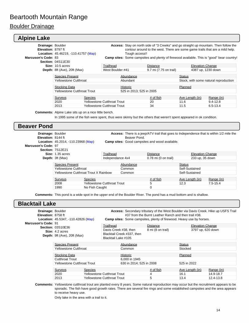
Beartooth Mountain RangeBoulder Drainage
Alpine LakeDrainage: BoulderElevation: 8797 ftLocation: 45.46219, -110.41757 (Map)
Marcuson's Code: 83Section: 04S11E30
Size: 10.5 acresDepth: 8ft (Ave), 20ft (Max)
Access: Stay on north side of "3 Creeks" and go straight up mountain. Then follow thecontour around to the west. There are some game trails that are a mild help.Tough access!!
Camp sites: Some campsites and plenty of firewood available. This is "good" bear country!
Trailhead Distance Elevation ChangeWest Boulder #41 9.7 mi (7.75 on trail) 4387 up, 1230 down
Species Present Abundance StatusYellowstone Cutthroat Abundant Stock, with some natural reproduction
Stocking Data Historic PlannedYellowstone Cutthroat Trout 525 in 2013; 525 in 2005
Surveys Species # of fish Ave Length (in) Range (in)2020 Yellowstone Cutthroat Trout 20 11.6 9.4-12.82013 Yellowstone Cutthroat Trout 34 11.5 6.5-13.4
Comments: Alpine Lake sits up on a nice little bench.
In 1995 some of the fish were spent, thus were skinny but the others that weren't spent appeared in ok condition.
Beaver PondDrainage: BoulderElevation: 8144 ftLocation: 45.2014, -110.23968 (Map)
Marcuson's Code: 97Section: 7S12E21
Size: 1.35 acresDepth: 3ft (Max)
Access: There is a jeep/ATV trail that goes to Independence that is within 1/2 mile theBeaver Pond.
Camp sites: Good campsites and wood available.
Trailhead Distance Elevation ChangeIndependance 4x4 0.78 mi (0 on trail) 233 up, 35 down
Species Present Abundance StatusYellowstone Cutthroat Common Self-SustainedYellowstone Cutthroat Trout X Rainbow Common Self-Sustained
Surveys Species # of fish Ave Length (in) Range (in)2008 Yellowstone Cutthroat Trout 5 12.3 7.5-15.41990 No Fish Caught 0
Comments: This pond is a wide spot in the upper end of the Boulder River. The pond has a mud bottom and is shallow.
Blacktail LakeDrainage: BoulderElevation: 8758 ftLocation: 45.5347, -110.42826 (Map)
Marcuson's Code: 91Section: 03S10E36
Size: 4.2 acresDepth: 9ft (Ave), 20ft (Max)
Access: Secondary tributary of the West Boulder via Davis Creek. Hike up USFS Trail#37 from the Burnt Leather Ranch and then trail #38.
Camp sites: Some campsites, plenty of firewood. Heavy use by horses.
Trailhead Distance Elevation ChangeDavis Creek #38, thenBlacktail Creek #337, thenBlacktail Lake #105
8 mi (8 on trail) 3797 up, 620 down
Species Present Abundance StatusYellowstone Cutthroat Common Stocked
Stocking Data Historic PlannedCutthroat Trout 6,000 in 1945Yellowstone Cutthroat Trout 630 in 2014; 525 in 2008 525 in 2022
Surveys Species # of fish Ave Length (in) Range (in)2020 Yellowstone Cutthroat Trout 4 16.1 14.9-18.72013 Yellowstone Cutthroat Trout 5 13.4 12.4-13.8
Comments: Yellowstone cutthroat trout are planted every 8 years. Some natural reproduction may occur but the recruitment appears to besporadic. The fish have good growth rates. There are several fire rings and some established campsites and the area appearsto receive heavy use.
Only lake in the area with a trail to it.
14

Blue LakeDrainage: BoulderElevation: 9558 ftLocation: 45.19955, -110.211 (Map)
Marcuson's Code: 31Section: 07S12E27
Size: 10.2 acresDepth: 12ft (Ave), 27ft (Max)
Access: Located in the headwaters of the East Fork of the Boulder River nearHaystack Peak. There is a jeep/ATV trail up the Main Boulder nearIndependence. The lake is about 200 yards from the end of the jeep/ATV trail.
Camp sites: Campsites are available and there is firewood
Trailhead Distance Elevation ChangeIndependence 4x4 2.5 mi (1 on trail) 800 up, 800 downCross-country fromIndependence
1.5 mi (0 on trail) 150 ft up, 150 ft down
Species Present Abundance StatusYellowstone Cutthroat Common Stocked
Stocking Data Historic PlannedCutthroat Trout 2,000 in 1965Yellowstone Cutthroat Trout 1,000 in 2018; 900 in 2017 1,020 in 2021; 1,020 in 2025
Surveys Species # of fish Ave Length (in) Range (in)2020 Yellowstone Cutthroat Trout 14 9.8 5.9-12.22017 No Fish Caught 02017 Yellowstone Cutthroat Trout 4 15.4 13.5-18.3
Comments: Blue Lake is stocked every 4 years because of the relatively easy access. The 2020 sample was a short 2.25 hour daytime netset that caught 4 Yellowstone Cutthroat Trout. The Crew also angled 10 YCT.
Bramble Creek Lake 38Drainage: BoulderElevation: 8508 ftLocation: 45.36948, -110.24429 (Map)
Marcuson's Code: 38Section: 5S12E28
Size: 1.62 acresDepth: 1ft (Ave), 3ft (Max)
Access: Headwaters of Bramble Creek. It is a 3 mile hike up Bramble Creek. No Trailexists.
Camp sites: Nice campsite and there is firewood present.
Trailhead Distance Elevation Changeno trail, leave from HellsCanyon Campground, followBramble Creek.
1.89 mi (0 on trail) 3500 up, 112 down
Species Present Abundance StatusYellowstone Cutthroat Rare Unknown
Comments: There are 4 Bramble Lakes (38, 39, 40, & 41). Bramble Lake #39 and #41 have fish. Bramble Lake 39 is planted withYellowstone Cutthroat and some of these fish may get into Bramble Lake 38 but the lake is too shallow to set a net. Anglerreported that on 8/27/1989 Bramble Lake 38 was dry.
Bramble Creek Lake 39 (Bramble #1)Drainage: BoulderElevation: 8889 ftLocation: 45.36614, -110.24857 (Map)
Marcuson's Code: 39Section: 5S12E28
Size: 4.08 acresDepth: 26ft (Max)
Access: Approximately 3 miles up Bramble Creek. No Trail exists. Tough hike butmaybe try staying just north of the creek drainage first 1/2 to avoid dead fall.
Camp sites: Beautiful place to camp. Plenty of firewood.
Trailhead Distance Elevation Changeleave from Hells CanyonCampground, follow BrambleCreek up.
3 mi (0 on trail) 2789 up, 112 down
Species Present Abundance StatusYellowstone Cutthroat Unknown Stocked
Stocking Data Historic PlannedCutthroat Trout 3,000 in 1965Yellowstone Cutthroat Trout 300 in 2017; 330 in 2009 330 in 2024
Surveys Species # of fish Ave Length (in) Range (in)2018 Yellowstone Cutthroat Trout 19 9.8 9.0-10.91991 No Fish Caught 0
Comments: Bramble #39 was stocked in 2017. Some of the previous plants may have been missed. The FWP crew found plenty of fatYellowstone Cutthroat here in 2018. They should grow quite well the next few years. The lake is somewhat turbid. Visibility wasabout 3 feet in 2018.
15

Bramble Lake #41 (Bramble #3)Drainage: BoulderElevation: None ftLocation: 45.36389, -110.25982 (Map)
Marcuson's Code: 41Section: 05S12E28
Size: 4.25 acresDepth: 70ft (Max)
Access: Approximately 3 miles up Bramble Creek. No Trail exists and these lakes aremoderately hard to find. The climb up the mountain is tough. Try staying justnorth of the creek drainage first 1/2 to avoid deadfall.
Camp sites: Firewood is present. Nice campsites (a few good flat spots).
Trailhead Distance Elevation Changeleave from Hells CanyonCampground, follow BrambleCreek up.
3 mi (0 on trail) 3652 up, 204 down
Species Present Abundance StatusYellowstone Cutthroat Abundant Stocked
Surveys Species # of fish Ave Length (in) Range (in)2018 Yellowstone Cutthroat Trout 20 15.3 13.3-17.71991 Yellowstone Cutthroat Trout 9 11.6 9.8-14.2
Comments: In 2018, the mountain lakes crew angled 20 Yellowstone Cutthroat up to 17.7 inches long. Fish were observed attempting tospawn along the shoreline.
Bridge LakeDrainage: BoulderElevation: 9614 ftLocation: 45.26612, -110.34525 (Map)
Marcuson's Code: 36Section: 06S11E34
Size: 14.2 acresDepth: 28ft (Ave), 42ft (Max)
Access: North East of Crow Mountain. Trail #25 climbs 10 miles to this lake from theBoulder River. The trail is excellent the first 9.5 miles.
Camp sites: Nice campsites, especially 1/2 mile below but the firewood is a little scarce.
Trailhead Distance Elevation ChangeBridge Creek #25 10 mi (9.5 on trail) 3500 up, 384 down
Species Present Abundance StatusYellowstone Cutthroat Common StockedYellowstone Cutthroat Common Stocked
Stocking Data Historic PlannedYellowstone Cutthroat Trout 2,130 in 2019; 2,130 in 2013 2,130 in 2025
Surveys Species # of fish Ave Length (in) Range (in)2012 Yellowstone Cutthroat Trout 21 13.5 8.2-16.82006 Yellowstone Cutthroat Trout 34 9.4 6.8-15.8
Comments: Abundant forage available results in some exceptional fish. This is a beautiful cirque lake with volcanic rock all around that ispopular and shows some heavy use.
Burnt Gulch LakeDrainage: BoulderElevation: 9109 ftLocation: 45.244, -110.1478 (Map)
Marcuson's Code: 26Section: 07S13E7
Size: 9.1 acresDepth: 22ft (Ave), 43ft (Max)
Access: From the main Boulder Road it is 14 miles up Upsidedown trail or 10 miles upRainbow Creek/Box Canyon trail. The lake sits 1/2 mile north Of ColumbineCreek confluence. The last 1/2 mile of the hike is cross country and about 600ft easy climb.
Camp sites: Plenty of good campsites and lots of firewood available.
Trailhead Distance Elevation ChangeUpsidedown Trail #26 14 mi (12.5 on trail) 3942 up, 1170 downBox Canyon #27, then Trail#28
9.5 mi (8.5 on trail) 2529 ft up, 319 ft down
Species Present Abundance StatusYellowstone Cutthroat Common Self-Sustained
Stocking Data Historic PlannedYellowstone Cutthroat Trout 975 in 2019; 3,978 in 1985
Surveys Species # of fish Ave Length (in) Range (in)2018 No Fish Caught 02018 Yellowstone Cutthroat Trout 8 10.0 8.2-14.22009 Yellowstone Cutthroat Trout 15 13.5 8.7-17.8
Comments: The FWP crew sample in 2018 found few average sized YCT. There wer lots of Columbia Spotted frogs and tadpoles.Can also be reached from Upsidedown Trail - Horseshoe Lake rainbow crk. Trail - columbine crk. - then cross country.
16

Camp LakeDrainage: BoulderElevation: 8905 ftLocation: 45.47217, -110.11503 (Map)
Marcuson's Code: 3Section: 04S13E22
Size: 7.8 acresDepth: 28ft (Ave), 58ft (Max)
Access: Head of Canyon Creek. Take Picket Pin-Iron Mountain Road to ChromeMountain and then it is 2.5 miles cross country from Chrome Mountain.
Camp sites: One excellent campsite. Plenty of firewood available.
Trailhead Distance Elevation ChangeChrome Mtn 4X4 Road, thenoff-trail
2.5 mi (0 on trail) 226 up, 711 down
Species Present Abundance StatusYellowstone Cutthroat Common Self-Sustained
Surveys Species # of fish Ave Length (in) Range (in)2015 Yellowstone Cutthroat Trout 35 10.0 4.7-12.72008 Yellowstone Cutthroat Trout 26 9.3 5.9-11.9
Comments: Camp Lake is outside AB Wilderness boundary. Fish from the 2016 survey were thin and 25 of the 35 fish sample wereobtained with 3.5 hrs of angling. This is good day hike material.
Chickadee LakeDrainage: BoulderElevation: 9671 ftLocation: 45.2768, -110.15835 (Map)
Marcuson's Code: 15Section: 6S13E30
Size: 6.64 acresDepth: 8ft (Max)
Access: Take the trail up Upsidedown Creek and then approximately 1 mile of crosscountry to the lake.
Camp sites: Camping is excellent just below the lake. There is some firewood below.
Trailhead Distance Elevation ChangeUpsidedown Trail #26 9.5 mi (8.5 on trail) 4141 up, 846 down
Species Present Abundance StatusYellowstone Cutthroat Common Self-SustainedYellowstone Cutthroat Common Self-Sustained
Surveys Species # of fish Ave Length (in) Range (in)2012 Yellowstone Cutthroat Trout 11 11.4 6.9-16.02003 Yellowstone Cutthroat Trout 5 14.6 13.0-15.7
Comments: There is a spring fed spawning area located in the inlet. In 2012 the fish were in average condition. The 2012 sample wascollected with 2 hours of angling effort.
Davis LakeDrainage: BoulderElevation: 8790 ftLocation: 45.48054, -110.42739 (Map)
Marcuson's Code: 87Section: 04S10E24
Size: 5.1 acresDepth: 5ft (Ave), 15ft (Max)
Access: Headwaters of Davis Creek on the West Boulder. Follow Trail #37 up DavisCreek 3 miles past Trail #38 then cross country to the lake. Last 3 miles aretough 1 mile / hour!
Camp sites: Plenty of firewood and many campsites are available. Be Bear Aware!
Trailhead Distance Elevation ChangeDavis Creek #38 9.5 mi (7.5 on trail) 4130 up, 767 down
Species Present Abundance StatusYellowstone Cutthroat Common Self-Sustained
Stocking Data Historic PlannedCutthroat Trout 4,650 in 1934Yellowstone Cutthroat Trout 510 in 1979
Surveys Species # of fish Ave Length (in) Range (in)2017 Yellowstone Cutthroat Trout 14 12.7 9.4-16.41996 Yellowstone Cutthroat Trout 15 12.1 7.6-14.6
Comments: Beautiful place with goats, elk and deer. The access is tough and there is little use here. The YCT are reproducing well and arealso present in the pond above the lake. In 2017 FWP caught 14 YCT in 3 hr day net set.
17

Elk LakeDrainage: BoulderElevation: 9528 ftLocation: 45.22765, -110.31366 (Map)
Marcuson's Code: 35Section: 07S11E14
Size: 9.2 acresDepth: 10ft (Ave), 22ft (Max)
Access: It is 6 miles up Copper Creek Trail #15 to West Boulder Divide and then 2miles north along the divide to where you drop into the lake. It is a tough hikeup Elk Creek. An angler reported hiking up the north side of Elk Creek and ittook them 10-11 hours to reach the lake.
Camp sites: Some camping spots and firewood available.
Trailhead Distance Elevation ChangeCopper Creek 8 mi (6 on trail) 2800 up, 600 downInependence Road, justnorth of Elk Creek
4 mi (0 on trail) None ft up, None ft down
Species Present Abundance StatusYellowstone Cutthroat Abundant StockedYellowstone Cutthroat Abundant Stocked
Stocking Data Historic PlannedRainbow Trout 6,000 in 1936Yellowstone Cutthroat Trout 920 in 2020; 920 in 2014 920 in 2026
Surveys Species # of fish Ave Length (in) Range (in)2019 Yellowstone Cutthroat Trout 22 14.9 12.7-16.32012 Yellowstone Cutthroat Trout 9 15.1 12.8-18.9
Comments: The Yellowstone cutthroat grow well in Elk Lake. In 2019, 22 YCT were caught in an overnight net set. Great fishing spot that isfairly tough to get to.
Fish LakeDrainage: BoulderElevation: 9525 ftLocation: 45.2528, -110.1106 (Map)
Marcuson's Code: 25Section: 07S13E4
Size: 18.0 acresDepth: 27ft (Ave), 45ft (Max)
Access: Fish Lake is in the headwaters of the South Fork of Rainbow Creek. There aretwo trails that can get you there, Box Canyon up Rainbow Creek or theUpsidedown Trail.
Camp sites: There are great camping spots, firewood is limited.
Trailhead Distance Elevation ChangeRainbow Creek #27, then#28, then #211
10.25 mi (10 on trail) 3249 up, 642 down
Upsidedown Creek #26, then#28, then #211
12.50 mi (12.25 on trail) 4498 ft up, 1400 ft down
Species Present Abundance StatusYellowstone Cutthroat Abundant Self-Sustained
Stocking Data Historic PlannedBrook Trout 1,200 in 1944
Surveys Species # of fish Ave Length (in) Range (in)2018 Golden X Rainbow X Cutthroat 33 9.4 5.6-14.32004 Yellowstone Cutthroat Trout 8 10.5 9.3-11.8
Comments: Fish Lake is a very scenic location! MTFWp sampled in 2018 with angling. They found good fishing with fish up to 14 inches.Fish look like cutthroats that are hybridized with Rainbow and/or Golden Trout.
18

Great Falls Creek Lake, LowerDrainage: BoulderElevation: 9020 ftLocation: 45.43391, -110.28377 (Map)
Marcuson's Code: 55Section: 05S12E6
Size: 6.6 acresDepth: 9ft (Ave), 23ft (Max)
Access: Trail #18 up great Falls Creek. It's the first lake you come to ~7 miles from thetrailhead. It's slightly off the trail to the NW 6.5 miles up.
Camp sites: There are flat spots to camp on the trail side of the lake and lots of firewood.
Trailhead Distance Elevation ChangeGreat Falls Creek #18 7 mi (6.5 on trail) 4000 up, 400 down
Species Present Abundance StatusRainbow Trout Rare Self-SustainedYellowstone Cutthroat Abundant Stock, with some natural reproduction
Stocking Data Historic PlannedRainbow Trout 1,080 in 1978; 28,000 in 1933Yellowstone Cutthroat Trout 660 in 2020; 660 in 2012 660 in 2025
Surveys Species # of fish Ave Length (in) Range (in)2018 Yellowstone Cutthroat Trout 27 12.9 9.4-15.62014 Yellowstone Cutthroat Trout 50 10.7 5.7-16.3
Comments: This is a nice secluded location that does not receive very many visitors. Starting in 2007 Yellowstone cutthroat were stockedannually with intent to swamp out rainbow trout genetics. Legal harvest of rainbow trout is encouraged. MTFWP sampled in2014 and 2018 finding no sign of Rainbows.
Fish are plentiful and a few of the sampled fish were skinny likely due to the high abundance of fish in the lake. In 2014, 31 ofthe 51 fish sample was obtained by angling for 6 hours.
Horseshoe LakeDrainage: BoulderElevation: 9587 ftLocation: 45.26847, -110.18172 (Map)
Marcuson's Code: 11Section: 06S12E36
Size: 15.9 acresDepth: 4ft (Ave), 10ft (Max)
Access: This is the first lake encountered on the Upsidedown Creek Trail and receivesheavy use. The Upsidedown Trail is steep but very well maintained.
Camp sites: Camping is good but the firewood is picked over.
Trailhead Distance Elevation ChangeUpsidedown Creek Trail #26 7.5 mi (7.5 on trail) 3388 up, 268 down
Species Present Abundance StatusYellowstone Cutthroat Common Self-Sustained
Stocking Data Historic PlannedYellowstone Cutthroat Trout 291 in 1970
Surveys Species # of fish Ave Length (in) Range (in)2015 Yellowstone Cutthroat Trout 12 11.4 8.6-13.92007 Yellowstone Cutthroat Trout 15 9.2 5.5-14.0
Comments: Horseshoe Lake is shallow wide spot in the creek and has potential to winterkill. The July 2015 gill net sample was collectedduring cold conditions with 4 inches of fresh snow that may have decreased sampling efficiency.
Icicle LakeDrainage: BoulderElevation: 9471 ftLocation: 45.45127, -110.3361 (Map)
Marcuson's Code: 74Section: 4S11E26
Size: 6.25 acresDepth: 13ft (Max)
Access: Leave west Boulder Trail #41 between Trapper Creek and Three Creeks. Hikeup a steep, untrailed, very difficult 2.5 miles through large boulder fields to thelake. OR consider hiking across West Boulder Plateau from Great Falls Creek
Camp sites: Many campsites. Plenty of firewood.
Trailhead Distance Elevation ChangeWest Boulder Trail #41 10.5 mi (7.5 on trail) 5140 up, 1200 down
Species Present Abundance StatusRainbow Trout Abundant Self-Sustained
Surveys Species # of fish Ave Length (in) Range (in)2014 Rainbow Trout 15 13.5 11.7-15.22004 Rainbow Trout 11 9.9 8.0-12.1
Comments: Icicle Lake is a beautiful lake at timberline that shows little sign of human use.
Most fish were in good condition during 2014 survey. 7 of the 15 fish for the 2014 survey were obtained by angling for 5.5hours.
19

Kaufman Lake (Falls Creek Lake)Drainage: BoulderElevation: 8994 ftLocation: 45.38625, -110.36447 (Map)
Marcuson's Code: 76Section: 05S11E21
Size: 39.7 acresDepth: 16ft (Ave), 70ft (Max)
Access: Best route is up Four Mile Creek past Silver, Patient and West Boulder Lakesor up Speculator Creek leaving the trail at the switchbacks.
Camp sites: Camping is best in meadow near inlet. Firewood available.
Trailhead Distance Elevation ChangeFourmile Creek Trail #22,then trail #149
10 mi (7.5 on trail) 4785 up, 1965 down
Speculator Creek Trail #21 9 mi (7 on trail) 4640 ft up, 1400 ft down
Species Present Abundance StatusYellowstone Cutthroat Common Self-Sustained
Stocking Data Historic PlannedArctic Grayling 8,225 in 2013; 15,750 in 2012Golden Trout 10,000 in 1958Yellowstone Cutthroat Trout 20,000 in 1979; 3,850 in 1977
Surveys Species # of fish Ave Length (in) Range (in)2017 Arctic Grayling 16 12.5 11.5-13.42017 Yellowstone Cutthroat Trout 3 12.3 9.0-16.12009 Yellowstone Cutthroat Trout 19 14.7 9.8-16.0
Comments: In 2017 YCT were spawning in the stream. Crews observed YCT from 2 inches to 12 inches. Grayling were stocked as apossible high elevation brood source.
Lake ColumbineDrainage: BoulderElevation: 9151 ftLocation: 45.21762, -110.14352 (Map)
Marcuson's Code: 30Section: 07S13E17
Size: 5.3 acresDepth: 5ft (Ave), 10ft (Max)
Access: Usfs Trail #27 up the East Fork of the Boulder River.Camp sites: Firewood limited.
Trailhead Distance Elevation ChangeUpsidedown Creek Trail #26,ten #28, then #128 onColumbine Creek
15.0 mi (15 on trail) 4800 up, 2000 down
Box Canyon (RainbowCreek) Trail #27, then #28,then #128 on ColumbineCreek
11.5 mi (11.5 on trail) 2857 ft up, 340 ft down
Species Present Abundance StatusNo Fish Captured Unknown Unknown
Surveys Species # of fish Ave Length (in) Range (in)2007 No Fish Caught 0
Comments: Grayling were scheduled to be planted in 1984 but no record of an actual plant can be found (suspect plant cancelled atrequest of USFS). Crews sampled this lake in 2007 with an overnight gill net set 13 hours and captured no fish. This lake willlikely only be surveyed again if it has been stocked.
Lake McknightDrainage: BoulderElevation: 9181 ftLocation: 45.49057, -110.44325 (Map)
Marcuson's Code: 90Section: 04S10E13
Size: 10.8 acresDepth: 16ft (Ave), 60ft (Max)
Access: Trail #37 up Davis Creek on the West Boulder. Follow the trail up a tributarynorth of the lakes and then south. This is tough cross country hiking.
Camp sites: Couple really nice camp spots- some firewood.
Trailhead Distance Elevation ChangeDavis Creek Trail #38 9.5 mi (7.5 on trail) 4283 up, 721 downPine Creek Trail #47 6.0 mi (4.5 on trail) 4849 ft up, 1300 ft down
Species Present Abundance StatusGolden Trout Common Stocked
Stocking Data Historic PlannedGolden Trout 1,100 in 2005; 927 in 1992
Surveys Species # of fish Ave Length (in) Range (in)2017 Golden Trout 15 11.9 6.8-18.82009 Golden Trout 71 12.5 10.6-14.3
Comments: Lake Mcknight and Upper Mcknight Lakes are beautiful, isolated and hard to get to. The 2017 sample was an overnight net set.The population of golden trout appear to be self-sustaining thus no future stocking is planned.
20

Mirror LakeDrainage: BoulderElevation: 9784 ftLocation: 45.27744, -110.149 (Map)
Marcuson's Code: 16Section: 06S13E30
Size: 16.4 acresDepth: 34ft (Ave), 80ft (Max)
Access: On lake plateau in the headwaters of Rainbow Creek. Access via Usfs Trail#26.
Camp sites: Campsites best near the outlet. Some firewood nearby.
Trailhead Distance Elevation ChangeUpsidedown Creek Trail #26 10.75 mi (9.75 on trail) 4100 up, 780 down
Species Present Abundance StatusRainbow Trout Common Self-SustainedYellowstone Cutthroat Common Stock, with some natural reproduction
Stocking Data Historic PlannedYellowstone Cutthroat Trout 11,750 in 2019; 11,750 in 2018
Surveys Species # of fish Ave Length (in) Range (in)2016 Rainbow Trout 10 9.4 6.7-14.02016 Yellowstone Cutthroat Trout 33 8.1 4.7-11.42003 Rainbow Trout 8 10.4 8.0-12.0
Comments: In 2011 FWP began stocking Yellowstone cutthroat trout at high density in an attempt to swamp out rainbow trout. In 2016FWP sampled with gill nets and angling and caught mostly YCT and no no apparent hybrids.
Narrow Escape LakeDrainage: BoulderElevation: 9394 ftLocation: 45.29884, -110.14972 (Map)
Marcuson's Code: 4Section: 06S13E19
Size: 11.6 acresDepth: 11ft (Ave), 20ft (Max)
Access: Headwaters of Hawley Creek. The access is best from Rainbow and/or MirrorLake but there is no trail from either lake. To get to Narrow Escape travelaround the southwest side of Squeeze Lake.
Camp sites: Decent campsites at inlet and outlet. Plenty of firewood.
Trailhead Distance Elevation ChangeUpsidedown Creek 14.5 mi (11.5 on trail) 4000 up, 1000 downBox Canyon 14.5 mi (11.5 on trail) 3200 ft up, 500 ft down
Species Present Abundance StatusYellowstone Cutthroat Common Self-Sustained
Stocking Data Historic PlannedYellowstone Cutthroat Trout 1,100 in 1989; 1,100 in 1977
Surveys Species # of fish Ave Length (in) Range (in)2018 Yellowstone Cutthroat Trout 21 15.3 11.1-20.32001 Yellowstone Cutthroat Trout 9 12.4 8.4-14.8
Comments: The fishery is self-sustaining. The mountain lakes crew sampled in 2018 with netting and angling. They found really nice sizedcutthroats up to 20 inches long.
Prospect LakeDrainage: BoulderElevation: 9617 ftLocation: 45.36663, -110.35922 (Map)
Marcuson's Code: 43Section: 05S11E27
Size: 6.8 acresDepth: 30ft (Max)
Access: Hike Up Trail #22 along Fourmile Creek from the USFS station. From SilverLake follow the left fork of the inlet stream ~1 mile to prospect.
Camp sites: Fairly rocky, with little firewood. The camping is better at Silver Lake.
Trailhead Distance Elevation ChangeFourmile Creek Trail #22,then trail #149
8.5 mi (7.5 on trail) 3785 up, 408 down
Species Present Abundance StatusYellowstone Cutthroat Common Self-Sustained
Stocking Data Historic PlannedRainbow Trout 4,020 in 1989; 4,020 in 1980Yellowstone Cutthroat Trout 680 in 2012; 680 in 2011
Surveys Species # of fish Ave Length (in) Range (in)2020 Yellowstone Cutthroat Trout 3 13.5 13.4-13.72015 Yellowstone Cutthroat Trout 37 10.1 7.9-13.0
Comments: The chance of encountering other hikers is pretty good.
Prospect Lake was part of the Upper Boulder Yellowstone Cutthroat Trout restoration effort and from 2007 to 2009 gill netswere used to remove rainbow trout. Yellowstone Cutthroat Trout were stocked until 2012 when they became self-sustaining.
In 2015, 11 of the 36 fish sample was obtained by angling for 4 hours.In 2020 several small YCT were angled from the pond in the outlet
21

Rainbow Lake #2Drainage: BoulderElevation: 9448 ftLocation: 45.27254, -110.12745 (Map)
Marcuson's Code: 18Section: 6S13E32
Size: 26.03 acresDepth: 30ft (Max)
Access: From the Box Canyon Trailhead take trails #27/28/211 to the Rainbow Lakes.Access also by using the Upsidedown Trail.
Camp sites: There are good places to camp but firewood is picked over.
Trailhead Distance Elevation ChangeBox Canyon (RainbowCreek) Trail #27, then trail#28
11.25 mi (11.25 on trail) 3188 up, 400 down
Upsidedown Creek Trail #26,then trail #28
12.0 mi (12.0 on trail) 4000 ft up, 1000 ft down
Species Present Abundance StatusRainbow Trout Common Self-SustainedYellowstone Cutthroat Common Stock, with some natural reproduction
Stocking Data Historic PlannedCutthroat Trout 8,000 in 1932Rainbow Trout 3,500 in 1949Yellowstone Cutthroat Trout 13,000 in 2020; 13,000 in 2019 13,000 in 2021; 13,000 in 2022
Surveys Species # of fish Ave Length (in) Range (in)2018 Rainbow Trout 11 8.7 6.4-11.22018 Yellowstone Cutthroat Trout 17 9.2 7.4-10.72016 Rainbow Trout 13 8.7 6.8-11.52016 Yellowstone Cutthroat Trout 22 8.6 7.2-10.5
Comments: This is the largest of the seven lakes. This is a popular area. Rainbow lakes were netted in 2011 and 2012 to try to remove RB.YCT have been stocked heavily to try to swamp out remaining RB. MTFWP samples in 2016 and 2018 caught Rainbow andCutthroat.
Rainbow Lake #3Drainage: BoulderElevation: 9432 ftLocation: 45.26747, -110.12583 (Map)
Marcuson's Code: 19Section: 6S13E33
Size: 8.28 acresDepth: 25ft (Max)
Access: From the Box Canyon Trailhead take trails #27/28/211 to the Rainbow Lakes.Access also by using the Upsidedown Trail.
Camp sites: There are good places to camp but firewood is picked over.
Trailhead Distance Elevation ChangeBox Canyon (RainbowCreek) Trail #27, then trail#28
11 mi (11 on trail) 3157 up, 400 down
Upsidedown Creek Trail #26,then trail #28
11.50 mi (11.50 on trail) 4000 ft up, 1000 ft down
Species Present Abundance StatusRainbow Trout Common Self-SustainedYellowstone Cutthroat Common Stock, with some natural reproduction
Stocking Data Historic PlannedYellowstone Cutthroat Trout 4,150 in 2020; 4,150 in 2019 4,150 in 2021; 4,150 in 2022
Surveys Species # of fish Ave Length (in) Range (in)2018 Rainbow Trout 2 9.0 8.9-9.22018 Yellowstone Cutthroat Trout 16 8.6 7.6-10.42016 Rainbow Trout 10 8.9 6.9-10.32016 Yellowstone Cutthroat Trout 30 8.5 5.4-10.1
Comments: Rainbow Lakes is a popular area and sees quite a bit of use. All 6 Rainbow lakes were netted in 2011-2012 to try to removeRB. YCT have been stocked heavily to try to swamp out remaining RB. FWP samples in 2016 and 2018 caught mostlyCutthroat, only a couple Rainbows.
22

Rainbow Lake #4Drainage: BoulderElevation: 9407 ftLocation: 45.26238, -110.12912 (Map)
Marcuson's Code: 20Section: 6S13E32
Size: 10.52 acresDepth: 35ft (Max)
Access: From the Box Canyon Trailhead take trails #27/28/211 to the Rainbow Lakes.Access also by using the Upsidedown Trail.
Camp sites: There are good places to camp but firewood is picked over.
Trailhead Distance Elevation ChangeBox Canyon (RainbowCreek) Trail #27, then trail#28
10.5 mi (10.5 on trail) 3100 up, 368 down
Upsidedown Creek Trail #26,then trail #28
11 mi (11 on trail) 3945 ft up, 923 ft down
Species Present Abundance StatusRainbow Trout Common Self-SustainedYellowstone Cutthroat Common Stock, with some natural reproduction
Stocking Data Historic PlannedYellowstone Cutthroat Trout 5,250 in 2020; 5,250 in 2019 5,250 in 2021; 5,250 in 2022
Surveys Species # of fish Ave Length (in) Range (in)2018 Rainbow Trout 22 7.5 4.8-10.42018 Yellowstone Cutthroat Trout 12 8.9 7.4-10.42016 Rainbow Trout 10 8.6 6.7-11.72016 Yellowstone Cutthroat Trout 25 8.6 4.1-10.6
Comments: All 6 Rainbow Lakes were netted in 2011 and 2012 to remove RB. YCT have been stocked heavily to try to swamp outremaining RB. FWP samples in 2016 and 2018 caught Rainbow and Cutthroat.
Rainbow Lake 5Drainage: BoulderElevation: 9679 ftLocation: 45.27304, -110.12117 (Map)
Marcuson's Code: 21Section: 6S13E33
Size: 5.85 acresDepth: 12ft (Max)
Access: From the Box Canyon Trailhead take trails #27/28/211 to the Rainbow Lakes.Access also by using the Upsidedown Trail.
Camp sites: Many well used campsites. Firewood is picked over.
Trailhead Distance Elevation ChangeBox Canyon (RainbowCreek) Trail #27, then trail#28
12 mi (12 on trail) 3440 up, 483 down
Upsidedown Creek Trail #26,then trail #28
12.75 mi (12.75 on trail) 4279 ft up, 1038 ft down
Species Present Abundance StatusRainbow Trout Common Self-SustainedYellowstone Cutthroat Common Stock, with some natural reproduction
Stocking Data Historic PlannedYellowstone Cutthroat Trout 2,900 in 2020; 2,900 in 2019 2,900 in 2021; 2,900 in 2022
Surveys Species # of fish Ave Length (in) Range (in)2018 Rainbow Trout 1 9.6 9.6-9.62018 Yellowstone Cutthroat Trout 14 8.7 7.3-11.72016 Rainbow Trout 2 9.5 8.9-10.12016 Yellowstone Cutthroat Trout 18 8.9 7.8-9.8
Comments: The Rainbow Lakes were netted in 2011 and 2012 to remove RB. YCT have been stocked heavily to try to swamp outremaining RB. FWP samples in 2016 and 2018 caught mostly Cutthroats, only a couple Rainbow.
23

Rainbow Lake 6Drainage: BoulderElevation: 9765 ftLocation: 45.27612, -110.11729 (Map)
Marcuson's Code: 22Section: 6S13E28
Size: 1.83 acresDepth: 10ft (Max)
Access: From the Box Canyon Trailhead take trails #27/28/211 to the Rainbow Lakes.Access also by using the Upsidedown Trail.
Camp sites: Many well used campsites. Firewood is limited.
Trailhead Distance Elevation ChangeBox Canyon (RainbowCreek) Trail #27, then trail#28
12 mi (12 on trail) 3462 up, 461 down
Upsidedown Creek Trail #26,then trail #28
12.6 mi (12.6 on trail) 4300 ft up, 1150 ft down
Species Present Abundance StatusRainbow Trout Common Self-SustainedYellowstone Cutthroat Common Stock, with some natural reproduction
Stocking Data Historic PlannedYellowstone Cutthroat Trout 900 in 2020; 900 in 2019 900 in 2021; 900 in 2022
Surveys Species # of fish Ave Length (in) Range (in)2016 Rainbow Trout 4 9.5 7.0-11.32016 Yellowstone Cutthroat Trout 13 8.5 5.0-11.32007 Rainbow Trout 5 7.7 5.8-8.5
Comments: This lake is a wide spot in the creek. Rainbow Lakes were netted in 2011 and 2012 to remove RB. Also YCT are being stockedheavily to swamp out remaining RB.
Rainbow Lake 7Drainage: BoulderElevation: 9732 ftLocation: 45.27582, -110.11237 (Map)
Marcuson's Code: 23Section: 6S13E28
Size: 8.24 acresDepth: 24ft (Max)
Access: From the Box Canyon Trailhead take trails #27/28/211 to the Rainbow Lakes.Access also by using the Upsidedown Trail. Headwater lake on e RainbowCreek
Camp sites: Many well used campsites. No firewood.
Trailhead Distance Elevation ChangeBox Canyon (RainbowCreek) Trail #27, then trail#28
12.25 mi (12.25 on trail) 3469 up, 464 down
Upsidedown Creek Trail #26,then trail #28
12.75 mi (12.75 on trail) 4307 ft up, 1019 ft down
Species Present Abundance StatusRainbow Trout Common Self-SustainedYellowstone Cutthroat Common Stock, with some natural reproduction
Stocking Data Historic PlannedYellowstone Cutthroat Trout 4,100 in 2019; 4,100 in 2018
Surveys Species # of fish Ave Length (in) Range (in)2018 Yellowstone Cutthroat Trout 34 9.0 6.1-10.92016 Yellowstone Cutthroat Trout 28 9.0 7.3-10.5
Comments: All Rainbow Lakes were netted in 2011 and 2012 to remove RB. YCT were stocked heavily to try to swamp out remaining RB.No RB were caught in FWP surveys in 2016 and 2018.
24

Silver LakeDrainage: BoulderElevation: 9138 ftLocation: 45.36095, -110.3499 (Map)
Marcuson's Code: 42Section: 05S11E34
Size: 10.0 acresDepth: 8ft (Ave), 30ft (Max)
Access: Hike up Fourmile Creek on Trail #22 test #149 from the Forest Service cabinon the Boulder River.
Camp sites: Excellent camping but firewood getting picked over by campers.
Trailhead Distance Elevation ChangeFourmile Creek Trail #22,then trail #149
7.5 mi (7.5 on trail) 3100 up, 300 down
Species Present Abundance StatusYellowstone Cutthroat Common Self-Sustained
Stocking Data Historic PlannedCutthroat Trout 10,560 in 1931Rainbow Trout 500 in 1989; 12,000 in 1939Yellowstone Cutthroat Trout 1,000 in 2012; 1,000 in 2011
Surveys Species # of fish Ave Length (in) Range (in)2020 Rainbow Trout 5 10.6 9.3-11.82020 Yellowstone Cutthroat Trout 16 10.0 5.5-13.72015 Yellowstone Cutthroat Trout 14 9.2 7.1-11.1
Comments: The lake receives heavy use.
Silver Lake was part of the Upper Boulder Yellowstone Cutthroat Trout restoration effort and from 2007 to 2009 gill nets wereused to remove rainbow trout. Yellowstone Cutthroat Trout were stocked until 2012, when they became self-sustaining.
Many fish were observed rising during the 2015 survey despite the relatively low number of fish sampled (14 captured).
The outlet has good spawning habitat and the spawning habitat at the inlet is fair.
Speculator LakeDrainage: BoulderElevation: 9578 ftLocation: 45.37641, -110.34424 (Map)
Marcuson's Code: 45Section: 05S11E27
Size: 9.7 acresDepth: 21ft (Ave), 35ft (Max)
Access: Best to access from Silver Lake. Get to silver on Trail #22 test #149 upFourmile Creek from the forest service station on the boulder river.Good Trailbut deadfall makes the hike difficult.
Camp sites: Questionable campsites. Scarce firewood. Better below.
Trailhead Distance Elevation ChangeFourmile Creek Trail #22,then trail #149
9.5 mi (7.5 on trail) 4300 up, 1070 down
Speculator Creek Trail #21 8.00 mi (6.75 on trail) 4532 ft up, 747 ft down
Species Present Abundance StatusYellowstone Cutthroat Abundant Stocked
Stocking Data Historic PlannedYellowstone Cutthroat Trout 1,455 in 2016; 1,450 in 2008
Surveys Species # of fish Ave Length (in) Range (in)2014 Yellowstone Cutthroat Trout 45 12.5 9.2-16.72006 Yellowstone Cutthroat Trout 22 13.1 10.3-14.5
Comments: Multiple year classes of Yellowstone cutthroat trout present. Fish were easily caught with hook and line for the survey.
Fish were in good condition and only a couple skinny fish were sampled. In 2015, 19 of the 61 fish sample was obtained byangling for 2.7 hours.
25

Squeeze LakeDrainage: BoulderElevation: 9591 ftLocation: 45.29167, -110.14558 (Map)
Marcuson's Code: 5Section: 06S13E19
Size: 7.0 acresDepth: 20ft (Ave), 22ft (Max)
Access: Easy access from Mirror/Rainbow Lakes. The Upsidedown Trail and BoxCanyon Trail both can be used to get you most of the way but the last part ofthe trip is cross country hiking.
Camp sites: Some campsites and lots of firewood.
Trailhead Distance Elevation ChangeUpsidedown Trail 13.5 mi (11.5 on trail) 3770 up, 670 downBox Canyon Trail 15.5 mi (13.5 on trail) 2859 ft up, 100 ft down
Species Present Abundance StatusYellowstone Cutthroat Common Stocked
Stocking Data Historic PlannedYellowstone Cutthroat Trout 700 in 2019; 700 in 2011
Surveys Species # of fish Ave Length (in) Range (in)2018 Yellowstone Cutthroat Trout 8 12.5 10.2-14.82016 No Fish Caught 02016 Yellowstone Cutthroat Trout 13 9.6 7.3-11.6
Comments: In 2016 the mountain lakes crew sampled with 2 nets set for 2.5 hrs and angling. The nets caught no fish but angling caught 13YCT in 4 hrs. The fishing was pretty good for decent size YCT. In 2018 the crew sampled again with netting and angling findingfewer fish that had not grown very much.
Trout LakeDrainage: BoulderElevation: 6196 ftLocation: 45.33742, -110.23027 (Map)
Marcuson's Code: 37Section: 06S12E4
Size: 0.9 acresDepth: 3ft (Ave), 5ft (Max)
Access: Near the boulder river road north of hillary bridge. Just east of the boulderriver.
Camp sites: Questionable camping. No firewood.
Trailhead Distance Elevation ChangeNone - Vehicle Access 0 mi (0 on trail) 0 up, 0 down
Species Present Abundance StatusYellowstone Cutthroat Common Stocked
Stocking Data Historic PlannedCutthroat Trout 2,940 in 1956Rainbow Trout 602 in 1984; 500 in 1983Yellowstone Cutthroat Trout 180 in 2020; 200 in 2019 200 in 2021; 200 in 2022
Surveys Species # of fish Ave Length (in) Range (in)2008 Yellowstone Cutthroat Trout 8 10.3 7.3-14.01996 Yellowstone Cutthroat Trout 7 9.0 8.3-10.8
Comments: Planted yearly with ct. Good supply of freshwater shrimp. Crayfish present. Subject to winterkill. Small pond with easy access.Cabin on lake. Camping in nearby campgrounds.
Stocked every year. Planted fish are generally large test small catchables. '93 - 14.6". '95 - 13.9". '96 - 6.1 test 13.9". '97 - 6.7".'98 - 7.5 test 10.6", '99 - 6.5 test 13.8", '00 - 6.3 test 12.0", '01 - 7.3 test 11.6", '02 - 9.8 test 11.3", 03-08 7-11"
No sign of larger fish in '96.Sample before the yearly plant to assess overwinter survival.
Upper Mcknight LakeDrainage: BoulderElevation: 9200 ftLocation: 45.48847, -110.4475 (Map)
Marcuson's Code: 89Section: 04S10E14
Size: 3.4 acresDepth: 9ft (Ave), 20ft (Max)
Access: Hike up Davis Creek on Usfs Trail #38 then cross country up to the lake. Seelake mcknight also.
Camp sites: Good camp spots, some firewood.
Trailhead Distance Elevation ChangeWest Boulder, Davis Cr 12.5 mi (10.5 on trail) 3584 up, 0 down
Species Present Abundance StatusGolden Trout Common Stocked
Surveys Species # of fish Ave Length (in) Range (in)2017 Golden Trout 17 10.6 8.3-16.52009 Golden Trout 41 12.1 9.2-14.8
Comments: See comments for lake mcknight. The mcknight lakes may be accessed directly up the outlet stream, but it is very steep, withlots of deadfalls and rock slides to negotiate. 2017 sample 5 hr day net set. GT seem to be Self Susstaining
26

Weasel Lake #48Drainage: BoulderElevation: 9441 ftLocation: 45.40954, -110.30182 (Map)
Marcuson's Code: 48Section: 5S11E12
Size: 8.28 acresDepth: 75ft (Max)
Access: Hike Up Trail #18 along great Falls Creek, then south x-country thru saddle.Then side hill up the valley to the lakes.
Camp sites: Many camping sites. Plenty of firewood. There appears to be little use here.
Trailhead Distance Elevation ChangeGreat Falls Creek 10 mi (7.75 on trail) 4800 up, 400 down
Species Present Abundance StatusYellowstone Cutthroat Common Self-Sustained
Surveys Species # of fish Ave Length (in) Range (in)2018 Yellowstone Cutthroat Trout 51 9.7 5.0-12.02009 Yellowstone Cutthroat Trout 10 9.3 6.1-10.8
Comments: There are 7 Lakes in the chain. Two have fish. #48 has a self-sustaining CT population and #51 is stocked. MTFWP crewangled both lakes in 2018. Fishing was very good for average sized cutthroat. Fish were spawning where inlet comes in from#51.
Weasel Lake #51Drainage: BoulderElevation: 9872 ftLocation: 45.41262, -110.31047 (Map)
Marcuson's Code: 51Section: 5S11E12
Size: 5.79 acresDepth: 35ft (Max)
Access: Hike Up Trail #18 along great Falls Creek, then south x-country thru saddle.Then side hill up the valley to the lakes.
Camp sites: There are a few flat spots near the outlet and very little wood. It is best tocamp at #48.
Trailhead Distance Elevation ChangeGreat Falls Creek 10 mi (7.75 on trail) 4800 up, 400 down
Species Present Abundance StatusYellowstone Cutthroat Common Stocked
Surveys Species # of fish Ave Length (in) Range (in)2018 Yellowstone Cutthroat Trout 79 12.0 8.4-13.92009 Yellowstone Cutthroat Trout 29 13.4 7.7-16.2
Comments: There are 7 Lakes in the chain. Two have fish. #48 has a self-sustaining pop. #51 is stocked. Both were sampled in 2018 andfound good numbers of average sized cutthroat. Scenic place but access is not a cake walk!
West Boulder LakeDrainage: BoulderElevation: 9794 ftLocation: 45.37663, -110.36064 (Map)
Marcuson's Code: 75Section: 05S11E27
Size: 13.0 acresDepth: 26ft (Ave), 55ft (Max)
Access: Take Trail #22 from fourmile 7 miles to Silver Lake. Head x-country n AlongCreek to next lake. Then climb west thru a saddle and drop into lake.
Camp sites: There are few good places to camp but there is no firewood.
Trailhead Distance Elevation ChangeFourmile Creek 9 mi (7 on trail) 4500 up, 500 down
Species Present Abundance StatusYellowstone Cutthroat Common Stocked
Stocking Data Historic PlannedGolden Trout 5,000 in 1958Yellowstone Cutthroat Trout 1,300 in 2019; 1,300 in 2011
Surveys Species # of fish Ave Length (in) Range (in)2017 Yellowstone Cutthroat Trout 17 15.0 14.2-15.92009 Yellowstone Cutthroat Trout 21 15.7 13.2-17.6
Comments: 2017 FWP survey obtained with angling. Great fishing for fat, healthy fish.
27

Clarks Fork Drainage
Abandoned LakeDrainage: Clarks ForkElevation: 10045 ftLocation: 45.00942, -109.60332 (Map)
Marcuson's Code: 243Section: 9S17E26
Size: 9.65 acresDepth: 8ft (Ave), 25ft (Max)
Access: Trail 614/620 from Island Lake on Hwy 212. The lake is 7 miles north testwest of Island Lake. Elevation change 600'.
Camp sites: Nice campsites but no firewood. Above treeline.
Trailhead Distance Elevation ChangeTrail #620, then #619 fromIsland Lake CG
10.5 mi (8.5 on trail) 2292 up, 1802 down
Trail #619 from BeartoothLake CG
8 mi (6 on trail) 2378 ft up, 1264 ft down
Species Present Abundance StatusBrook Trout Abundant Self-Sustained
Surveys Species # of fish Ave Length (in) Range (in)2018 Brook Trout 34 8.0 4.7-10.62008 Brook Trout 67 8.6 5.7-10.5
Comments: Abandoned Lake is a typical brookie lake. Plenty of fish that are fairly small. Some harvest could help this lake. The 2018 FWPsample was obtained with angling and found smaller fish that were in good shape, not stunted.
Albino LakeDrainage: Clarks ForkElevation: 9994 ftLocation: 45.01491, -109.58117 (Map)
Marcuson's Code: 245Section: 09S17E25
Size: 39.2 acresDepth: 48ft (Ave), 149ft (Max)
Access: Trail #614/620 from Island Lake on Hwy 212 will take you past Flake Lakethen north between Mutt and Jeff Lakes and along east side of Becker Lake.
Camp sites: Some camping - very little firewood.
Trailhead Distance Elevation ChangeIsland Lake #614/620 6 mi (6 on trail) 500 up, 50 down
Species Present Abundance StatusYellowstone Cutthroat Abundant Stocked
Stocking Data Historic PlannedBrook Trout 5,000 in 1940Cutthroat Trout 2,110 in 1959Yellowstone Cutthroat Trout 7,340 in 2019; 7,840 in 2015 7,840 in 2023
Surveys Species # of fish Ave Length (in) Range (in)2018 Yellowstone Cutthroat Trout 14 8.0 5.7-14.22016 Yellowstone Cutthroat Trout 43 12.6 8.8-15.0
Comments: A popular, stocked Lake. In 2016 FWP set 2 nets for 2 hrs each, both caught plenty of YCT 10-14 inches. Some reproductionmay be taking place.
Alp LakeDrainage: Clarks ForkElevation: 9597 ftLocation: 45.05423, -109.64822 (Map)
Marcuson's Code: 200Section: 09S17E8
Size: 2.8 acresDepth: 14ft (Ave), 25ft (Max)
Access: Trails from the Beartooth Butte area on Hwy 212 serve the area. The lake isNE of GreenLake.
Camp sites: Firewood is scarce. Campsites are nearby.
Trailhead Distance Elevation ChangeClay Butte Lookout Trail#6141, then #619
11 mi (9 on trail) 3234 up, 3170 down
Beartooth Lake Trail #619 11.5 mi (9.5 on trail) 3400 ft up, 2693 ft down
Species Present Abundance StatusBrook Trout Common Self-SustainedYellowstone Cutthroat Common Self-Sustained
Stocking Data Historic PlannedYellowstone Cutthroat Trout 311 in 1987; 319 in 1979
Surveys Species # of fish Ave Length (in) Range (in)2017 Brook Trout 18 7.6 6.5-8.72017 Yellowstone Cutthroat Trout 6 12.6 8.2-14.12006 Brook Trout 25 7.0 6.0-8.02006 Yellowstone Cutthroat Trout 10 11.8 8.5-14.5
Comments: 2017 sample was obtained with angling. There is spawning gravel in both inlet and outlet and some CT reproduction isoccurring. There is no short way to Alp Lake. Can also get to this Lake from Ivy Lake Jeep Trail #130 Crazy Crk. Trail #568hiking past Farley and Elaine
28

Anchor LakeDrainage: Clarks ForkElevation: 9997 ftLocation: 45.05715, -109.70836 (Map)
Marcuson's Code: 124Section: 09S16E11
Size: 12.0 acresDepth: 32ft (Ave), 90ft (Max)
Access: Approximately 8 miles NE of Kersey Lake via Canyon Lake or 12 miles fromKersey via Russel test Otter lakes. North of Jorden Lake.
Camp sites: No firewood. Questionable camp spots.
Trailhead Distance Elevation ChangeIvy Lake Jp Trail #130 toTrail #568 to Traill #154
8 mi (7 on trail) 2950 up, 1000 down
Species Present Abundance StatusGolden Trout Common Unknown
Surveys Species # of fish Ave Length (in) Range (in)2020 No Fish Caught 02016 Golden Trout 1 12.4 12.4-12.4
Comments: GT are stocked in Desolation and Big Butte, some drift down to Anchor. FWP netting caught 1 GT in 2007, 11 GT in 2010, and1 GT 2016.
Aquarius LakeDrainage: Clarks ForkElevation: 9187 ftLocation: 45.05729, -109.81077 (Map)
Marcuson's Code: 63Section: 09S15E12
Size: 11.6 acresDepth: 21ft (Ave), 65ft (Max)
Access: Cross country hike up Sedge Creek or an old Abandoned Trail leaving USFSTrail #567 between Twin-russel Lake. No good trail and the access is fairlytough.
Camp sites: Good campsites and firewood available. Fires have burned near the lake.
Trailhead Distance Elevation ChangeClarks Fork Trail #3, then4x4 road #306, then trail#564
5 mi (3.5 on trail) 1953 up, 800 down
Clarks Fork Trail #3 6 mi (3.25 on trail) 1684 ft up, 538 ft down
Species Present Abundance StatusYellowstone Cutthroat Common Self-Sustained
Stocking Data Historic PlannedArctic Grayling 20,000 in 1955Yellowstone Cutthroat Trout 600 in 1977; 2,000 in 1970
Surveys Species # of fish Ave Length (in) Range (in)2015 Yellowstone Cutthroat Trout 33 10.5 7.2-15.22007 Yellowstone Cutthroat Trout 8 9.9 7.0-12.5
Comments: A pretty lake that receives quite a bit of fishing use.
Astral LakeDrainage: Clarks ForkElevation: 9397 ftLocation: 45.09316, -109.9018 (Map)
Marcuson's Code: 24Section: 08S15E31
Size: 5.2 acresDepth: 2ft (Ave), 4ft (Max)
Access: Either from the Goose Lake jeep road or up Star Creek from the BroadwaterTrail.
Camp sites: Campsites and firewood limited.
Trailhead Distance Elevation ChangeGoose Lake Jeep Trail#3230
.50 mi (0 on trail) 20 up, 400 down
Lady of the Lake Trail #31 toTrail #573
4.5 mi (3.5 on trail) 1150 ft up, 680 ft down
Species Present Abundance StatusBrook Trout Abundant Self-Sustained
Surveys Species # of fish Ave Length (in) Range (in)2014 Brook Trout 43 7.4 6.1-9.02008 Brook Trout 25 7.4 6.0-9.1
Comments: Astral is a pretty lake with an abundant brook trout population that is easy to catch. The legal harvest of brook trout isencouraged here.
The 2014 sampled was obtained by 3 hours of angling.
29

Bald Knob LakeDrainage: Clarks ForkElevation: 9420 ftLocation: 45.07808, -109.79463 (Map)
Marcuson's Code: 81Section: 09S16E6
Size: 38.4733 acresDepth: 38ft (Ave), 38ft (Max)
Access: Excellent Usfs Trail from Kersey Lake.Camp sites: Pretty good camping at Bald Knob Lake. Firewood available.
Trailhead Distance Elevation ChangeClarks Fork Trail #3 8.5 mi (8.5 on trail) 2400 up, 1038 down
Species Present Abundance StatusBrook Trout Common Self-Sustained
Surveys Species # of fish Ave Length (in) Range (in)2017 Brook Trout 10 7.4 5.4-8.12008 Brook Trout 41 7.6 5.0-8.6
Comments: FWP survey in 2017 with angling for 15 minutes, small EB easy to catch. No changes since 2008 survey. Angler harvestingmay help.
Basin Lake (Picasso Lake)Drainage: Clarks ForkElevation: 9978 ftLocation: 45.08614, -109.80836 (Map)
Marcuson's Code: 84Section: 8S15E36
Size: 7.38 acresDepth: 7ft (Ave), 28ft (Max)
Access: From clarks Fork Trailhead take Trail #3 past Kersey Lake to Trail #567, upRussel Creek past bald knob lake to skull lake then west 1/4 mile.
Camp sites: There are good camp spots but firewood limited.
Trailhead Distance Elevation ChangeClarks Fork Trail #3 9.5 mi (9.25 on trail) 3036 up, 1160 down
Species Present Abundance StatusGolden Trout Common Stock, with some natural reproduction
Stocking Data Historic PlannedGolden Trout 3,000 in 2017; 1,000 in 2011 1,620 in 2022Yellowstone Cutthroat Trout 2,200 in 1971
Surveys Species # of fish Ave Length (in) Range (in)2019 Golden Trout 7 10.8 8.0-15.62017 Golden Trout 8 12.5 7.8-16.5
Comments: FWP sample in 2019 with angling and day net set. Didn't catch any angling Numerous groups of fish seen on redds along theshoreline in 2017. There are golden trout in the pond below (Pablo Lake)
Big Butte LakeDrainage: Clarks ForkElevation: 10175 ftLocation: 45.0609, -109.7025 (Map)
Marcuson's Code: 125Section: 09S16E12
Size: 22.1 acresDepth: 14ft (Ave), 55ft (Max)
Access: Approximately 8 miles NE of Kersey Lake via Canyon Lake or 12 miles fromKersey via Russel and Otter Lakes or via Moose Lake Jeep Trail.
Camp sites: No firewood. A few places to camp.
Trailhead Distance Elevation ChangeMoose Lk Jp Trail #130 10 mi (8.25 on trail) 2725 up, 700 downClarks Fork Trailhead 11.2 mi (4.5 on trail) 2089 ft up, None ft down
Species Present Abundance StatusGolden Trout Unknown Stocked
Stocking Data Historic PlannedGolden Trout 2,210 in 2017; 2,200 in 2012 2,210 in 2023Yellowstone Cutthroat Trout 7,500 in 1968
Surveys Species # of fish Ave Length (in) Range (in)2020 No Fish Caught 02016 No Fish Caught 0
Comments: No fish caught in 2015 or 2016. 2015 sample was a 6.5 hr daytime gillnet set and 4 hours of angling. 2016 was overnight netset. No signs of fish were observed. No fish were observed during the 1988 and 1990 survey. GT spawning in outlet in '10.
30

Big Moose LakeDrainage: Clarks ForkElevation: 7990 ftLocation: 45.00448, -109.76617 (Map)
Marcuson's Code: 70Section: 09S16E33
Size: 83.8 acresDepth: 46ft (Max)
Access: Trail #3 from Kersey Lake or 4x4 road from beartooth highway.Camp sites: There are several large campsites and plenty of firewood.
Trailhead Distance Elevation ChangeClarks Fork trail #3 then trail#567
6.5 mi (6.5 on trail) 937 up, 900 down
trail #568 to trail #567leaving from 130 1A 4x4Road
3 mi (3 on trail) 517 ft up, 600 ft down
Species Present Abundance StatusBrook Trout Common Self-SustainedRainbow Trout Common Self-Sustained
Surveys Species # of fish Ave Length (in) Range (in)2018 No Fish Caught 02018 Rainbow Trout 4 14.5 13.6-15.41981 Brook Trout 6 7.3 6.5-8.71981 Rainbow Trout 17 11.1 6.9-15.6
Comments: Only 1/3 of the lake is in Montana. Big Moose is a big lake, tough to set a net. MTFWP crew angled 4 RB from near the inlet in2018. Some smaller fish were observed.
Bob LakeDrainage: Clarks ForkElevation: 9571 ftLocation: 45.08656, -109.91781 (Map)
Marcuson's Code: 12Section: 08S15E31
Size: 2.3 acresDepth: 6ft (Ave), 15ft (Max)
Access: The lake is 1/4 mile west of the Goose Lake Jeep Trail at a mid-point betweenlong and star lakes. Hike is ~8 miles without a 4-wheel drive
Camp sites: Camping sites and firewood exist.
Trailhead Distance Elevation ChangeGoose Lake Jeep Trail .25 mi (0 on trail) 100 up, 0 down
Species Present Abundance StatusBrook Trout Abundant Self-Sustained
Stocking Data Historic PlannedCutthroat Trout 16,800 in 1936
Surveys Species # of fish Ave Length (in) Range (in)2013 Brook Trout 14 7.8 6.7-8.71996 Brook Trout 10 7.4 6.4-8.5
Comments: Fish were stunted. The lake is outside the a-b wilderness. Fish move freely between Bob and Dick Lakes.
The 2013 survey was obtained using anling for 1 hour
Broadwater LakeDrainage: Clarks ForkElevation: 8623 ftLocation: 45.06017, -109.84858 (Map)
Marcuson's Code: 23Section: 09S15E10
Size: 93.6 acresDepth: 64ft (Max)
Access: Kersey Lake Trail #567 to jeep Trail #306 to Broadwater River Trail #564.Fight through some burned deadfalls on east shore of curl lake to isthmus.
Camp sites: Plenty of firewood and campsites available. E. Side burned '88
Trailhead Distance Elevation ChangeClarks Fork 5 mi (4.25 on trail) 600 up, 100 down
Species Present Abundance StatusBrook Trout Common Self-SustainedYellowstone Cutthroat Rare Unknown
Stocking Data Historic PlannedBrook Trout 7,500 in 1933Yellowstone Cutthroat Trout 1,000 in 2014; 7,875 in 2003
Surveys Species # of fish Ave Length (in) Range (in)2014 Brook Trout 38 8.6 3.9-16.52014 Yellowstone Cutthroat Trout 1 17.3 17.3-17.32004 Brook Trout 7 11.1 9.3-12.5
Comments: There is little evidence of human use here.
Yellowstone cutthroat trout present in very low abundance but the one sampled was in very good condition.
31

Broadwater MeadowDrainage: Clarks ForkElevation: 8394 ftLocation: 45.04362, -109.8478 (Map)
Marcuson's Code: 1Section: 09S15E15
Size: 10.88 acresDepth: 4ft (Max)
Access: Jeep road near chief joseph campground on Hwy 212 approximately 3 mileseast of cooke city.
Camp sites: Firewood and campsites available.
Trailhead Distance Elevation ChangeClarks Fork 3.25 mi (3.25 on trail) 300 up, 100 down
Species Present Abundance StatusBrook Trout Abundant Self-Sustained
Comments: Brook trout are abundant but small. Occasional cutthroat and grayling are seen.
Too shallow to set net. Sample with hook and line if needed.
Burnt Bacon LakeDrainage: Clarks ForkElevation: 8994 ftLocation: 45.01216, -109.65922 (Map)
Marcuson's Code: 231Section: 09S17E29
Size: 15.0 acresDepth: 18ft (Ave), 46ft (Max)
Access: Trails from Hwy 212 near Beartooth Butte. Lake is SE of Lake elaine. NE 1/4mile from the north point of granite Lake.
Camp sites: No real good campsites but lots of firewood.
Trailhead Distance Elevation ChangeClay Butte 8.5 mi (8 on trail) 330 up, 900 downMuddy Creek 9.5 mi (9 on trail) 870 ft up, 0 ft down
Species Present Abundance StatusNo Fish Captured Unknown Unknown
Surveys Species # of fish Ave Length (in) Range (in)2014 No Fish Caught 01989 No Fish Caught 0
Comments: Spawning would be restricted. Beautiful Lake. Was due to be planted with grayling in '84 but no record of the plant can befound. (plant was cancelled at request of USFS). No survey is going to be conducted unless fish are planted.
Plant grayling when available. Clear with USFS. No sign of '88 fire.
Canyon LakeDrainage: Clarks ForkElevation: 8794 ftLocation: 45.03951, -109.77119 (Map)
Marcuson's Code: 118Section: 09S16E17
Size: 65.7 acresDepth: 22ft (Ave), 87ft (Max)
Access: Trail #567 past Kersey Lake to fox lake then cross Russel Creek and find theprimative trail up the west side of farley creek toward canyon lake.
Camp sites: Plenty of firewood, there are a few decent campsites.
Trailhead Distance Elevation ChangeClarks Fork 6 mi (4.5 on trail) 1000 up, 300 down
Species Present Abundance StatusYellowstone Cutthroat Trout X Rainbow Common Self-Sustained
Surveys Species # of fish Ave Length (in) Range (in)2019 Yellowstone Cutthroat Trout 24 11.0 6.7-15.12011 Yellowstone Cutthroat Trout X Rainbow 16 12.3 7.3-15.5
Comments: Right in the heart of grizzly country! 2019 sample with angling and netting. Fish were tough to catch with rod and reel but thenet caught plenty. Fish appear to be mainly cutthroats with a bit of RB hybridization.
32

Castle Lake (Queer Lake)Drainage: Clarks ForkElevation: 9594 ftLocation: 45.05089, -109.65799 (Map)
Marcuson's Code: 187Section: 9S17E8
Size: 20.75 acresDepth: 16ft (Ave), 49ft (Max)
Access: Trail #618 4 miles to fork. Then 6 miles to Thiel Lake test on to kidney lake.Ford Creek at wright lake test take trail to green lake. Head n thru saddle testup creek.
Camp sites: Plenty of firewood and camping is excellent.
Trailhead Distance Elevation ChangeClay Butte 12.5 mi (12 on trail) 1300 up, 600 downMuddy Creek 13.7 mi (12.2 on trail) 1444 ft up, None ft down
Species Present Abundance StatusBrook Trout Common Self-Sustained
Surveys Species # of fish Ave Length (in) Range (in)2017 Brook Trout 25 5.9 4.6-9.62006 Brook Trout 26 7.9 6.5-11.0
Comments: Very pretty place. Good spawning potential in both inlet and outlet. Could also take crazy Lakes Trail #568 that starts near ivylake (ivy lake jeep trail). Hike past Farley Lake, lake elaine and follow sierra crk. 2017 FWP sample with angling. Lots of tinybrookies.
Cliff LakeDrainage: Clarks ForkElevation: 9381 ftLocation: 45.08604, -109.8633 (Map)
Marcuson's Code: 50Section: 08S15E33
Size: 6.6 acresDepth: 7ft (Ave), 20ft (Max)
Access: Get off the Goose Lake Jeep Trail just before long lake (trail is on south sideof long lake outlet). Hike east to trail 31then north to sky Top Creek and headsoutheast(cross sky Top Creek) at the confluence with lower Aero Creek. Notrail exists.
Camp sites: Camping sites and firewood available.
Trailhead Distance Elevation ChangeGoose Lake Jeep Trail 3.75 mi (3.5 on trail) 710 up, 830 downLady Of The Lake #31 5.75 mi (5.5 on trail) None ft up, None ft down
Species Present Abundance StatusBrook Trout Common Self-SustainedBrook Trout Common Self-Sustained
Stocking Data Historic PlannedArctic Grayling 10,000 in 1955Cutthroat Trout 7,500 in 1949Yellowstone Cutthroat Trout 1,650 in 1977
Surveys Species # of fish Ave Length (in) Range (in)2020 Brook Trout 8 14.6 6.8-19.12012 Brook Trout 9 14.8 14.3-15.1
Comments: The eb population fluctuates by periodic winterkill. The fishery will always be changing and/or may die out in a hard winter.
Periodic winterkill is allowing fish to grow larger by keeping population numbers low. Spawning areas are not evident. MFWPsampled in 06 no fish netted or seen seen. 2012 survey caught 9 EB in 14.5 hr net set.
Cloverleaf Lake 215Drainage: Clarks ForkElevation: 10194 ftLocation: 45.03008, -109.61979 (Map)
Marcuson's Code: 215Section: 9S17E22
Size: 13.5 acresDepth: 24ft (Ave), 66ft (Max)
Access: 8 miles up from Island Lake. Good Trail to golden lake then over the hillnorthwest.
Camp sites: Some flat spots for camping. Firewood is non-existent.
Trailhead Distance Elevation ChangeIsland Lake Wy 8.5 mi (6 on trail) 1000 up, 200 down
Species Present Abundance StatusYellowstone Cutthroat Abundant Self-Sustained
Surveys Species # of fish Ave Length (in) Range (in)2013 Yellowstone Cutthroat Trout 21 10.7 6.6-13.12005 Yellowstone Cutthroat Trout 20 10.1 7.5-14.5
Comments: This area has become a 'destination' type area. Many campers come and go. '75 plant of 29,726 CT's was distributed between#'s 215, 216, test 223.
Plants of CT's went into These Lakes in 1936 and 1967. Lot's of mountain goats in this area. Watch out for your camp stuff!Better camping down by wall or Martin Lakes. During 2013 survey spawning was observed at inlet and outlet.
33
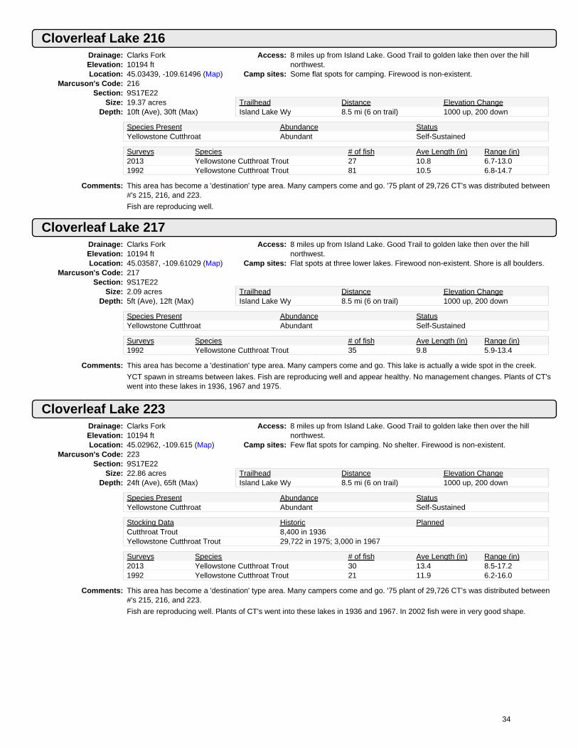
Cloverleaf Lake 216Drainage: Clarks ForkElevation: 10194 ftLocation: 45.03439, -109.61496 (Map)
Marcuson's Code: 216Section: 9S17E22
Size: 19.37 acresDepth: 10ft (Ave), 30ft (Max)
Access: 8 miles up from Island Lake. Good Trail to golden lake then over the hillnorthwest.
Camp sites: Some flat spots for camping. Firewood is non-existent.
Trailhead Distance Elevation ChangeIsland Lake Wy 8.5 mi (6 on trail) 1000 up, 200 down
Species Present Abundance StatusYellowstone Cutthroat Abundant Self-Sustained
Surveys Species # of fish Ave Length (in) Range (in)2013 Yellowstone Cutthroat Trout 27 10.8 6.7-13.01992 Yellowstone Cutthroat Trout 81 10.5 6.8-14.7
Comments: This area has become a 'destination' type area. Many campers come and go. '75 plant of 29,726 CT's was distributed between#'s 215, 216, and 223.
Fish are reproducing well.
Cloverleaf Lake 217Drainage: Clarks ForkElevation: 10194 ftLocation: 45.03587, -109.61029 (Map)
Marcuson's Code: 217Section: 9S17E22
Size: 2.09 acresDepth: 5ft (Ave), 12ft (Max)
Access: 8 miles up from Island Lake. Good Trail to golden lake then over the hillnorthwest.
Camp sites: Flat spots at three lower lakes. Firewood non-existent. Shore is all boulders.
Trailhead Distance Elevation ChangeIsland Lake Wy 8.5 mi (6 on trail) 1000 up, 200 down
Species Present Abundance StatusYellowstone Cutthroat Abundant Self-Sustained
Surveys Species # of fish Ave Length (in) Range (in)1992 Yellowstone Cutthroat Trout 35 9.8 5.9-13.4
Comments: This area has become a 'destination' type area. Many campers come and go. This lake is actually a wide spot in the creek.
YCT spawn in streams between lakes. Fish are reproducing well and appear healthy. No management changes. Plants of CT'swent into these lakes in 1936, 1967 and 1975.
Cloverleaf Lake 223Drainage: Clarks ForkElevation: 10194 ftLocation: 45.02962, -109.615 (Map)
Marcuson's Code: 223Section: 9S17E22
Size: 22.86 acresDepth: 24ft (Ave), 65ft (Max)
Access: 8 miles up from Island Lake. Good Trail to golden lake then over the hillnorthwest.
Camp sites: Few flat spots for camping. No shelter. Firewood is non-existent.
Trailhead Distance Elevation ChangeIsland Lake Wy 8.5 mi (6 on trail) 1000 up, 200 down
Species Present Abundance StatusYellowstone Cutthroat Abundant Self-Sustained
Stocking Data Historic PlannedCutthroat Trout 8,400 in 1936Yellowstone Cutthroat Trout 29,722 in 1975; 3,000 in 1967
Surveys Species # of fish Ave Length (in) Range (in)2013 Yellowstone Cutthroat Trout 30 13.4 8.5-17.21992 Yellowstone Cutthroat Trout 21 11.9 6.2-16.0
Comments: This area has become a 'destination' type area. Many campers come and go. '75 plant of 29,726 CT's was distributed between#'s 215, 216, and 223.
Fish are reproducing well. Plants of CT's went into these lakes in 1936 and 1967. In 2002 fish were in very good shape.
34

Companion LakeDrainage: Clarks ForkElevation: 9394 ftLocation: 45.08243, -109.90269 (Map)
Marcuson's Code: 15Section: 09S15E6
Size: 7.0845 acresDepth: 8ft (Ave), 24ft (Max)
Access: Companion Lake is on the Goose Lake Jeep Trail near long lake. Easyaccess. Without a 4-wheel drive the hike is about 2.5 miles.
Camp sites: There are many campsites and firewood is available.
Trailhead Distance Elevation ChangeGoose Lake Jeep Trail .25 mi (0 on trail) 0 up, 0 down
Species Present Abundance StatusBrook Trout Common Self-Sustained
Surveys Species # of fish Ave Length (in) Range (in)2014 Brook Trout 25 8.4 6.3-10.32008 Brook Trout 23 7.4 5.1-9.2
Comments: Lots of small brook trout. Legal harvest is encouraged.
The 2014 sample was obtained by angling 6 hours.
Copeland LakeDrainage: Clarks ForkElevation: 8767 ftLocation: 45.00616, -109.72645 (Map)
Marcuson's Code: 151Section: 09S16E35
Size: 36.0 acresDepth: 125ft (Max)
Access: Head north on Trail #568/612 from the Ivy Lake jeep trail. Trail #612 tocopeland splits off up 2 miles.
Camp sites: Plenty of firewood. Many nice camp spots.
Trailhead Distance Elevation ChangeIvy Lake Jeep Trail 2.5 mi (2.5 on trail) 1000 up, 150 downCrazy Creek 6 mi (6 on trail) 1717 ft up, None ft down
Species Present Abundance StatusBrook Trout Abundant Self-SustainedBrook Trout Abundant Self-Sustained
Stocking Data Historic PlannedCutthroat Trout 21,000 in 1934
Surveys Species # of fish Ave Length (in) Range (in)2020 Brook Trout 35 7.8 4.6-10.62012 Brook Trout 10 9.7 7.6-13.8
Comments: There is an outfitter camp near Copeland Lake. Surveys in 2012 and 2020 found good numbers of decent sized Brook Trout.
Corner LakeDrainage: Clarks ForkElevation: 9292 ftLocation: 45.07177, -109.89961 (Map)
Marcuson's Code: 7Section: 09S15E5
Size: 11.1 acresDepth: 15ft (Ave), 42ft (Max)
Access: Goose Lake Jeep Trail to within 1/4 mile of the lake. A 4-wheeler can make itto the lake but not a sport utility. 2 mile hike from Fisher Creek.
Camp sites: Plenty of firewood and campsites available.
Trailhead Distance Elevation ChangeGoose Lake Jeep Trail .25 mi (.25 on trail) 0 up, 0 down
Species Present Abundance StatusLake Chub Common Self-SustainedYellowstone Cutthroat Common Self-Sustained
Stocking Data Historic PlannedYellowstone Cutthroat Trout 500 in 2018; 1,002 in 1980
Surveys Species # of fish Ave Length (in) Range (in)2018 Lake Chub 32018 Yellowstone Cutthroat Trout 2 10.0 9.5-10.52011 Yellowstone Cutthroat Trout 11 11.0 6.5-14.0
Comments: Decent fishing for average sized YCT. Fish appear healthy. Lake Chubs are present.
35

Cradle LakeDrainage: Clarks ForkElevation: 9728 ftLocation: 45.06991, -109.77385 (Map)
Marcuson's Code: 95Section: 09S16E5
Size: 2.9 acresDepth: 16ft (Ave), 37ft (Max)
Access: Head to Russel Lake on a Good Trail from Kersey Lake then head northeastcross country.
Camp sites: Camp spots are few and far between with little fuel.
Trailhead Distance Elevation ChangeClarks Fork 8.25 mi (6.5 on trail) 2000 up, 300 down
Species Present Abundance StatusRainbow Trout Common Self-Sustained
Surveys Species # of fish Ave Length (in) Range (in)2012 Rainbow Trout 7 10.0 7.7-14.82007 Rainbow Trout 3 8.5 7.0-11.0
Comments: Rainbow planted in Gallery Lake find their way to cradle lake. In '87 they averaged 3.7" longer than the Gallery Lake fish.Sample along with Gallery Lake.
Spawning may be possible in the inlet. D. Hagenston 8-28-89 - 13" rb's. Dave hergenrider caught 25 rb's ~12" 1992.
Fish were very thin in 2002.Sample to assess reproduction.
Very Nice Lake, deep and cold. Access is fairly easy.Fwp sampled 07 3 fish, fat. 2012 survey 16 hr. set 7 Rb caught.
7 Rb caught.
Assess reproduction and consider stocking with Yct.
Crystal LakeDrainage: Clarks ForkElevation: 9952 ftLocation: 45.04957, -109.64036 (Map)
Marcuson's Code: 202Section: 09S17E16
Size: 27.5 acresDepth: 34ft (Ave), 85ft (Max)
Access: Trails from the Beartooth Butte area on Hwy 212 serve the area. The lake isNE of Lake Elaine.
Camp sites: A few campsites. Little use. Some firewood.
Trailhead Distance Elevation ChangeClay Butte 13.0 mi (12 on trail) 1600 up, 600 down
Species Present Abundance StatusYellowstone Cutthroat Common Stock, with some natural reproduction
Stocking Data Historic PlannedYellowstone Cutthroat Trout 2,445 in 2018; 2,750 in 2010 2,750 in 2025
Surveys Species # of fish Ave Length (in) Range (in)2017 Yellowstone Cutthroat Trout 15 12.0 6.7-13.92008 Yellowstone Cutthroat Trout 12 12.2 8.7-15.4
Comments: No evident spawning areas but reproduction is occurring.FWP sample in 2017 fishing was slow but many fish were rising inmiddle. 2 YCT were angled, 13 caught in net. Surveyed 08 5 fish angled in 45 min.
Curl LakeDrainage: Clarks ForkElevation: 8544 ftLocation: 45.05452, -109.84023 (Map)
Marcuson's Code: 22Section: 09S15E15
Size: 30.6 acresDepth: 45ft (Max)
Access: Kersey Lake Trail #567 to jeep Trail #306 to Broadwater River Trail #564.Fight thru burned deadfalls on east shore to isthmus for campsite.
Camp sites: Some campsites available but limited due to downfall. Firewood is abundant.
Trailhead Distance Elevation ChangeClarks Fork 4.25 mi (4.25 on trail) 600 up, 100 down
Species Present Abundance StatusBrook Trout Abundant Self-Sustained
Surveys Species # of fish Ave Length (in) Range (in)2014 Brook Trout 60 7.9 5.3-12.12004 Brook Trout 11 9.9 8.0-12.1
Comments: The 1988 fires swept through this area and the entire shoreline of Curl Lake was burned. There is a lot of downfall around thelake.
Brook trout abundance decreased after the fire but recovered by 2002.
36

Desolation LakeDrainage: Clarks ForkElevation: 10194 ftLocation: 45.06738, -109.71639 (Map)
Marcuson's Code: 127Section: 09S16E2
Size: 31.4 acresDepth: 24ft (Ave), 75ft (Max)
Access: About 14 miles from Kersey Lake. Hike to Russel then head northeast or usethe Ivy Lake Jeep Trail trailhead.
Camp sites: No firewood available. Some places to camp but very rocky.
Trailhead Distance Elevation ChangeIvy Lake Jp Trail #130 10.7 mi (8.25 on trail) 2825 up, 700 downClarks Fork Trailhead 12 mi (4.5 on trail) 2188 ft up, None ft down
Species Present Abundance StatusGolden Trout Common Stocked
Stocking Data Historic PlannedGolden Trout 3,140 in 2017; 3,100 in 2012 3,140 in 2023
Surveys Species # of fish Ave Length (in) Range (in)2020 No Fish Caught 02015 Golden Trout 32 9.8 7.0-16.6
Comments: FWP crew day set in 2020 found no sign of fish. The 2015 sample was collected with a 5.5 hour daytime gill net set. In 2015,one of the 33 fish sample was obtained by 6 hours of angling. Fish were challenging to catch with angling.
Diamond Lake (Cliff Lake)Drainage: Clarks ForkElevation: 8594 ftLocation: 45.0337, -109.7807 (Map)
Marcuson's Code: 146Section: 09S16E20
Size: 15.7823 acresDepth: 29ft (Ave), 83ft (Max)
Access: Trail #567 past Kersey Lake to fox lake trail. Cross Russel Creek below foxlake and up west side of farley creek. Cross creek below pond and head eastover saddle
Camp sites: Lots of firewood but flat spots for tents are tough to find.
Trailhead Distance Elevation ChangeClarks Fork 5.5 mi (4.5 on trail) 900 up, 500 down
Species Present Abundance StatusArctic Grayling Abundant Self-Sustained
Surveys Species # of fish Ave Length (in) Range (in)2019 Arctic Grayling 19 8.8 7.2-11.22011 Arctic Grayling 7 10.9 8.7-13.0
Comments: Progeny from Cliff Lake occasionally reach fox lake downstream. The canyon lake (farley Creek) Trail is inundated withdeadfalls and would be difficult for even the best hiker. FWP sample in 2019 with angling found grayling from 7-11 inches easyto catch.
Dick LakeDrainage: Clarks ForkElevation: 9561 ftLocation: 45.08537, -109.91912 (Map)
Marcuson's Code: 13Section: 08S15E31
Size: 1.9 acresDepth: 6ft (Ave), 15ft (Max)
Access: The lake is 1/4 mile west of the Goose Lake Jeep Trail at a mid-point betweenlong and star lakes. Hike is ~8 miles without a 4-wheel drive
Camp sites: Camping sites and firewood exist.
Trailhead Distance Elevation ChangeGoose Lake Jeep Trail .25 mi (0 on trail) 100 up, 0 down
Species Present Abundance StatusBrook Trout Common Self-Sustained
Surveys Species # of fish Ave Length (in) Range (in)2013 Brook Trout 12 8.3 6.4-10.11996 Brook Trout 12 7.2 5.9-8.5
Comments: The lake is outside the a-b wilderness.
Easy access from the Goose Lake Jeep Trail. Fish seem to be in good condition for self-sustaining brook trout. The 2013sample was obtained using anling for 2 hours
37

Dollar LakeDrainage: Clarks ForkElevation: 8971 ftLocation: 45.05145, -109.82018 (Map)
Marcuson's Code: 61Section: 09S15E14
Size: 1.1 acresDepth: 5ft (Ave), 12ft (Max)
Access: Kersey Lake Trail #567 to jeep Trail #306 to Broadwater River Trail #564.Head x-country before curl lake and up the east side of Sedge Creek.
Camp sites: Some camp spots . Lots of firewood.
Trailhead Distance Elevation ChangeClarks Fork 6 mi (4 on trail) 1100 up, 100 down
Species Present Abundance StatusYellowstone Cutthroat Common Self-Sustained
Surveys Species # of fish Ave Length (in) Range (in)2011 Yellowstone Cutthroat Trout 3 10.8 9.7-11.61999 Arctic Grayling 3 13.3 11.9-14.41999 Yellowstone Cutthroat Trout 19 8.0 6.0-10.5
Comments: Gr and CT drifted into dollar from aquarius. GR planted in Aquarius Lake in 1955. No sign of GR in 2011 FWP sample.Average size YCT. In the middle of the 1988 burn, not very pretty.
Donelson LakeDrainage: Clarks ForkElevation: 10394 ftLocation: 45.04769, -109.6181 (Map)
Marcuson's Code: NoneSection: 09S17E15
Size: 19.2405 acresDepth: 9ft (Ave), 8ft (Max)
Access:Camp sites:
Trailhead Distance Elevation Change
Species Present Abundance Status
Surveys Species # of fish Ave Length (in) Range (in)2013 No Fish Caught 0
Comments: Lake is fishless and should remain so
Surveyed lake in 2013 to confirm lake is still fishless. No fish captured or observed.
Estelle LakeDrainage: Clarks ForkElevation: 9197 ftLocation: 45.02744, -109.67212 (Map)
Marcuson's Code: 172Section: 09S17E19
Size: 18.7 acresDepth: 11ft (Ave), 30ft (Max)
Access: Clay Butte Trail #618. Take right fork 4 miles along. Go past Theil test KidneyLakes to Wright Lake then downstream past Little Falls test Robin Lake ~2miles.
Camp sites: Many nice places to camp. Plenty of firewood available.
Trailhead Distance Elevation ChangeClay Butte 10.5 mi (8.75 on trail) 800 up, 1100 downMuddy Cr/ivy Lake Trls 9.1 mi (7.8 on trail) 1182 ft up, None ft down
Species Present Abundance StatusBrook Trout Abundant Self-Sustained
Surveys Species # of fish Ave Length (in) Range (in)2015 Brook Trout 28 9.7 7.5-18.02006 Brook Trout 24 7.0 5.5-8.5
Comments: Majority of the fish sampled in the 2015 survey were obtained by 1 hour of angling. Only 3 of the 28 brook trout sampled werecollected with a 5 hour daytime gill net set.
38

Farley LakeDrainage: Clarks ForkElevation: 9778 ftLocation: 45.03512, -109.70772 (Map)
Marcuson's Code: 167Section: 09S16E24
Size: 24.0 acresDepth: 13ft (Ave), 35ft (Max)
Access: Trail #568/612 from Ivy Lake jeep Trail #130. Stay on #568 past #631 test#612. #568 goes to Farley Lake.
Camp sites: Some nice places to camp. Pretty spot. Some firewood.
Trailhead Distance Elevation ChangeIvy Lake Jp Trail #130 6.75 mi (6.75 on trail) 1900 up, 100 downCrazy Crk 9.25 mi (9.25 on trail) 2900 ft up, 100 ft down
Species Present Abundance StatusBrook Trout Abundant Self-Sustained
Surveys Species # of fish Ave Length (in) Range (in)2015 Brook Trout 32 9.4 6.5-10.62006 Brook Trout 36 10.3 7.3-11.5
Comments: Population size appears to fluctuate from year to year.
Brook trout were abundant in 2015 sample. The 2015 sample was obtained with 6.8 hours of angling.
Finger Lake (Hunger Lake)Drainage: Clarks ForkElevation: 9755 ftLocation: 45.08904, -109.84854 (Map)
Marcuson's Code: 47Section: 8S15E34
Size: 5.39 acresDepth: 9ft (Ave), 31ft (Max)
Access: The outlet drains into sky Top Creek near the confluence of lower Aero Creek.No Trail.
Camp sites: Pretty area for camping. Firewood plentiful.
Trailhead Distance Elevation ChangeLady Of The Lake Trail 5.5 mi (4 on trail) 1700 up, 400 downGoose Lake Jeep Trail 4.5 mi (3.5 on trail) 1150 ft up, 830 ft down
Species Present Abundance StatusBrook Trout Abundant Self-Sustained
Surveys Species # of fish Ave Length (in) Range (in)2017 Brook Trout 18 8.0 6.6-8.92005 Brook Trout 42 7.0 6.0-8.0
Comments: 2017 FWP sampled with angling. Typical brookie lake. EB are easy to catch, some fish are stunted. Excellent setting with greatviews.
Fizzle Lake (Dead Horse Lake, Windy Lake)Drainage: Clarks ForkElevation: 9835 ftLocation: 45.09489, -109.80758 (Map)
Marcuson's Code: 85Section: 8S15E36
Size: 35.82 acresDepth: 48ft (Max)
Access: Usfs Trail #567 from Kersey Lake. The lake is east of Fossil Lake.Camp sites: Some camping spots, but rocky. No firewood.
Trailhead Distance Elevation ChangeClarks Fork 9.5 mi (9 on trail) 2000 up, 280 down
Species Present Abundance StatusBrook Trout Abundant Self-Sustained
Surveys Species # of fish Ave Length (in) Range (in)2017 Brook Trout 22 6.9 4.5-7.82008 Brook Trout 60 7.9 6.3-9.1
Comments: Fish are overcrowded and are in poor condition. Surveyed 08 and 2017, no change here in 38 years, massive harvesting couldhelp improve this population.
39

Flat Rock LakeDrainage: Clarks ForkElevation: 10329 ftLocation: 45.06653, -109.63544 (Map)
Marcuson's Code: 190Section: 09S17E4
Size: 37.0 acresDepth: 32ft (Ave), 85ft (Max)
Access: 12 miles north of Beartooth Butte. Several Trails will get you near the lake. Goupstream from green lake.
Camp sites: Best to camp at lower elevations.No firewood or cover at lake.
Trailhead Distance Elevation ChangeClay Butte 17 mi (15.5 on trail) 1370 up, 900 downMuddy Creek 18 mi (16.5 on trail) 2070 ft up, 160 ft down
Species Present Abundance StatusYellowstone Cutthroat Abundant Stocked
Stocking Data Historic PlannedYellowstone Cutthroat Trout 3,700 in 2012; 3,700 in 2010 3,700 in 2022
Surveys Species # of fish Ave Length (in) Range (in)2017 Yellowstone Cutthroat Trout 24 10.8 7.9-15.22009 Yellowstone Cutthroat Trout 31 11.4 9.6-13.4
Comments: 2017 FWP sampled with angling. There were a couple size classes of YCT. YCT were planted in 2010 and 2012
Fox LakeDrainage: Clarks ForkElevation: 8085 ftLocation: 45.02462, -109.79854 (Map)
Marcuson's Code: 74Section: 09S15E24
Size: 111.4 acresDepth: 13ft (Ave), 75ft (Max)
Access: Usfs Trail #567 from Kersey Lake. Trail from Kersey is excellent. The trail tofox lake forks right off #567 1/4 mile from the lake.
Camp sites: Campsites at north end but firewood is tough to find.
Trailhead Distance Elevation ChangeClarks Fork 4.5 mi (4.5 on trail) 250 up, 250 down
Species Present Abundance StatusArctic Grayling Rare Self-SustainedBrook Trout Abundant Self-SustainedRainbow Trout Common Self-Sustained
Surveys Species # of fish Ave Length (in) Range (in)2020 Rainbow Trout 10 14.4 12.2-19.52008 No Fish Caught 0
Comments: FWP sampled in 2020 with angling. This is a big lake that is tough to set a net with our methods. EB are also present in thelake but none were caught in 2020 sample. A few grayling may make it down from Cliff Lake.
Fritter Lake (Hipshot Lake)Drainage: Clarks ForkElevation: 9742 ftLocation: 45.02884, -109.71566 (Map)
Marcuson's Code: 158Section: 09S16E23
Size: 9.7063 acresDepth: 20ft (Ave), 47ft (Max)
Access: North from Clay Butte Trailhead past Granite Lake, then NW to Lake Elaineand then west to Hipshot.
Camp sites: A few flat spots to camp at the south end. Firewood is available.
Trailhead Distance Elevation ChangeIvy Lake Jeep Road 6 mi (6 on trail) 1020 up, None downClarks Fork 12 mi (10.5 on trail) 2300 ft up, 550 ft down
Species Present Abundance StatusYellowstone Cutthroat Common Stocked
Stocking Data Historic PlannedYellowstone Cutthroat Trout 480 in 2019; 480 in 2011
Surveys Species # of fish Ave Length (in) Range (in)2015 Yellowstone Cutthroat Trout 27 14.7 12.5-19.42009 Yellowstone Cutthroat Trout 2 17.2 16.3-18.1
Comments: Hipshot lake generally produces good numbers of nice sized cutthroats. In 2015 a few larger fish were sampled that wereeither 12 years old or a product of a natural reproduction.
40

Fulcrum Lake (Mermaid Lake)Drainage: Clarks ForkElevation: 9788 ftLocation: 45.0877, -109.79998 (Map)
Marcuson's Code: 91Section: 8S15E36
Size: 6.93 acresDepth: 10ft (Ave), 30ft (Max)
Access: Along east rosebud-cooke City Trail #567. Mermaid is between skull andFossil Lakes. Go north over a small ridge from the south side of skull.
Camp sites: There are level places to camp but no firewood.
Trailhead Distance Elevation ChangeClarks Fork 9.5 mi (9.2 on trail) 2200 up, 150 down
Species Present Abundance StatusYellowstone Cutthroat Common Stocked
Stocking Data Historic PlannedYellowstone Cutthroat Trout 680 in 2016; 700 in 2006
Surveys Species # of fish Ave Length (in) Range (in)2019 Yellowstone Cutthroat Trout 50 10.9 8.3-16.72011 Yellowstone Cutthroat Trout 12 12.3 11.0-13.2
Comments: This lake is along the Busiest Trail in the beartooths. Stocking was pushed back to 2016 to allow 2 years extra rest. Hopefullygrowth will improve. FWP sample in 2019 with angling found good numbers of decent size YCT.
Gallery LakeDrainage: Clarks ForkElevation: 9994 ftLocation: 45.07517, -109.76382 (Map)
Marcuson's Code: 96Section: 09S16E4
Size: 7.4 acresDepth: 10ft (Ave), 40ft (Max)
Access: Take Trail #567 from the clarks fork trailhead to Russel Lake. Cross thebridge above the lake test head north x-country up a rocky chute.
Camp sites: No flat spots. Camp below. Scarce firewood.
Trailhead Distance Elevation ChangeClarks Fork #3 9 mi (6.5 on trail) 2350 up, 300 down
Species Present Abundance StatusNo Fish Captured Unknown Unknown
Stocking Data Historic PlannedArctic Grayling 400 in 2026Rainbow Trout 1,113 in 1997; 1,480 in 1989
Surveys Species # of fish Ave Length (in) Range (in)2020 No Fish Caught 02012 No Fish Caught 0
Comments: Rainbow were planted to filter downstream into Cradle Lake. That objective has been achieved. Planted with 150/acre in '97.We may lower numbers stocked to 100/acre in 2005. '02 fish were thin.1987 6 rbt 8.7-10.5"
Fish averaged 3.7" smaller than Cradle Lake fish in 1987. D. Hagenston 8/28/89 - 11" rb's. D. Fischer '97 fat 12-13" rb's.Frozen over 7/7/93. '94 - some reproduction is apparently occurring as a couple of 6" fish were also caught.
2002 - a fish ~15" was observed in the outlet. The outlet is deep and full of large boulders. Cancel further plants to assessreproduction.
Likely fishless. Consider stocking YCT. 2012 FWP survey zero fish caught in 14.5 hour set.
Golden LakeDrainage: Clarks ForkElevation: 10184 ftLocation: 45.02354, -109.59806 (Map)
Marcuson's Code: 236Section: 09S17E23
Size: 48.9 acresDepth: 23ft (Ave), 90ft (Max)
Access: Island Lake Trail #614/620 to flake lake. North between mutt test jeff lakesand along east side of Becker Lake. Then along s test w sides of albino.
Camp sites: Campsites scarce - no firewood available.
Trailhead Distance Elevation ChangeIsland Lake Wy 7 mi (6 on trail) 850 up, 200 down
Species Present Abundance StatusYellowstone Cutthroat Abundant Stocked
Stocking Data Historic PlannedYellowstone Cutthroat Trout 2,750 in 2018; 2,445 in 2010 2,445 in 2025
Surveys Species # of fish Ave Length (in) Range (in)2018 Yellowstone Cutthroat Trout 17 11.7 6.8-13.72016 Yellowstone Cutthroat Trout 10 13.3 6.9-15.4
Comments: Both Golden and Jasper are stocked and fish can easily move between them. 2016 FWP sample caught 12 YCT in 14.5 hr netset. Densities are likely higher than the catch in this net indicates. This area receives quite a bit of use.
41

Granite LakeDrainage: Clarks ForkElevation: 8781 ftLocation: 45.00425, -109.66604 (Map)
Marcuson's Code: 147Section: 09S17E32
Size: 228.0 acresDepth: 125ft (Max)
Access: Look for Muddy Creek Trail #612/568 along the beartooth Hwy, or accessfrom clay butte trail (downhill).
Camp sites: Excellent campsites and firewood.
Trailhead Distance Elevation ChangeClay Butte 8 mi (8 on trail) 0 up, 900 downMuddy Creek 7 mi (7 on trail) 540 ft up, 0 ft down
Species Present Abundance StatusBrook Trout Abundant Self-SustainedRainbow Trout Common Self-SustainedYellowstone Cutthroat Rare Self-Sustained
Surveys Species # of fish Ave Length (in) Range (in)2019 Brook Trout 5 9.1 7.3-11.52019 Rainbow Trout 2 12.3 11.0-13.72014 Brook Trout 22 8.7 5.9-11.62014 Rainbow Trout 2 9.6 7.5-11.7
Comments: The lake straddles the MT and WY state line. This is a big lake that is tough to sample with our methods. The low numberssampled in 2019 are likely not indicative of the actual population in the lake.
Green LakeDrainage: Clarks ForkElevation: 9335 ftLocation: 45.0339, -109.66368 (Map)
Marcuson's Code: 173Section: 09S17E20
Size: 35.7 acresDepth: 45ft (Ave), 129ft (Max)
Access: Clay Butte Trail #618 4 miles to Thiel Lake Trail #619. 6 miles to thiel then tokidney test wright. Ford stream test head up trail to trail lake. Green's beyond.Crazy lakes is best past copeland, farley test lake elaine
Camp sites: Some camping spots, plenty of firewood available.
Trailhead Distance Elevation ChangeClay Butte 11.25 mi (11.25 on trail) 1000 up, 600 downCrazy Lakes None mi (None on trail) None ft up, None ft down
Species Present Abundance StatusBrook Trout Abundant Self-Sustained
Stocking Data Historic PlannedBrook Trout 11,900 in 1937
Surveys Species # of fish Ave Length (in) Range (in)2012 Brook Trout 6 9.8 9.1-10.51995 Brook Trout 49 8.2 5.9-11.1
Comments: Very scenic. Mosquitoes abundant. This is a popular lake in the a-b wilderness. Water code #22-8037
'95 fish were average to thin. 2012 FWP set net for 3.5 hrs. caught zero EBT all 6 fish caught angling.
Green LakeDrainage: Clarks ForkElevation: 9778 ftLocation: 45.10031, -109.90091 (Map)
Marcuson's Code: 25Section: 08S15E30
Size: 4.8 acresDepth: 7ft (Ave), 16ft (Max)
Access: Accessed either from the Goose Lake Jeep Trail 1/4 mile past star lake or upStar Creek from the lady of the lake trail.
Camp sites: Campsites and firewood limited.
Trailhead Distance Elevation ChangeGoose Lake Jeep Trail 5 mi (4.5 on trail) 50 up, 250 down
Species Present Abundance StatusBrook Trout Abundant Self-Sustained
Surveys Species # of fish Ave Length (in) Range (in)2014 Brook Trout 23 9.7 7.6-11.31994 Brook Trout 20 8.6 3.8-13.3
Comments: This lake has a sandy bottom with many springs. It is a decent brook trout fishery. Similar to most brook trout lakes, fish inGreen Lake may benefit from harvest.
The 2014 sampled was obtained by angling for 4.5 hours.
42

Gus LakeDrainage: Clarks ForkElevation: 9997 ftLocation: 45.0038, -109.61035 (Map)
Marcuson's Code: 240Section: 09S17E34
Size: 16.7 acresDepth: 19ft (Max)
Access: Trail #614/620 from Island Lake on Hwy 212. The lake is just west oflonesome lake on the montana-wyoming state line. Easy access fromlonesome.
Camp sites: The lake is above timberline.
Trailhead Distance Elevation ChangeIsland Lake Wyo. 7 mi (4 on trail) 800 up, 0 down
Species Present Abundance StatusBrook Trout Abundant Self-Sustained
Surveys Species # of fish Ave Length (in) Range (in)2018 Brook Trout 30 8.6 6.5-10.22008 Brook Trout 22 8.6 6.1-10.7
Comments: MTFWP surveyed with angling in 2018. There were plenty of 8-10 Brookies.How long have brookies been in here? This lake was presumed to be fishless. Marcuson felt that EB's from lakes in wyowouldn't be able to move into Gus in summer. Did they use a spring freshet?
Heidi LakeDrainage: Clarks ForkElevation: 9758 ftLocation: 45.01577, -109.64465 (Map)
Marcuson's Code: 229Section: 09S17E28
Size: 8.2 acresDepth: 8ft (Ave), 25ft (Max)
Access: Trails from Hwy 212 near Beartooth Butte serve the area. The lake is NE ofGranite Lake.
Camp sites: Nice campsites (but Near Lake), plenty of firewood.
Trailhead Distance Elevation ChangeClay Butte 7 mi (6 on trail) 570 up, 280 downMuddy Creek 9 mi (8 on trail) 950 ft up, 0 ft down
Species Present Abundance StatusBrook Trout Abundant Self-Sustained
Surveys Species # of fish Ave Length (in) Range (in)2015 Brook Trout 32 7.0 4.4-8.52006 Brook Trout 30 7.3 6.5-9.5
Comments: Pretty spot where Brook Trout would benefit from some harvest. Legal harvest of Brook Trout is encouraged here.
The 2015 sample was obtained by angling for 2 hours.
Hidden LakeDrainage: Clarks ForkElevation: 9614 ftLocation: 45.00619, -109.62549 (Map)
Marcuson's Code: 234Section: 09S17E34
Size: 18.0 acresDepth: 46ft (Max)
Access: Trails from Hwy 212 near Beartooth Butte serve the area. The lake is east ofgranite lake. Find trail from tiel lake.
Camp sites: Camping is good at both ends of the lake. There is plenty of firewood
Trailhead Distance Elevation ChangeClay Butte 6.5 mi (6.5 on trail) 600 up, 280 downMuddy Creek 8.5 mi (8.5 on trail) 1420 ft up, 0 ft down
Species Present Abundance StatusYellowstone Cutthroat Abundant Self-Sustained
Stocking Data Historic PlannedBrook Trout 11,500 in 1937
Surveys Species # of fish Ave Length (in) Range (in)2018 Yellowstone Cutthroat Trout 27 8.9 6.1-12.82009 Yellowstone Cutthroat Trout 28 9.7 6.9-12.3
Comments: Hidden Lake is a scenic spot with good numbers of self-sustaining cutthroat. There is good spawning habitat in the inletstream. The 2018 sample was obtained with angling.
43

Indian Knife LakeDrainage: Clarks ForkElevation: 9794 ftLocation: 45.05441, -109.73058 (Map)
Marcuson's Code: 113Section: 09S16E10
Size: 5.3 acresDepth: 14ft (Ave), 35ft (Max)
Access: Take Trail #567 from Kersey Lake to Russel Lake. From Russel head east 3miles. The lake is east of Otter Lake.
Camp sites: Ok at head of the lake. Some firewood
Trailhead Distance Elevation ChangeClarks Fork 10.25 mi (10 on trail) 2100 up, 280 down
Species Present Abundance StatusBrook Trout Abundant Self-Sustained
Stocking Data Historic PlannedArctic Grayling 300 in 1985
Surveys Species # of fish Ave Length (in) Range (in)2016 Brook Trout 16 8.4 6.4-10.32005 Brook Trout 17 9.5 7.5-10.0
Comments: No GR in 2005 or 2016 samples. They have likely been extirpated by brook trout. GR were common prior to first brook troutbeing found in 1999. 2016 FWP sample EB in decent shape, not stunted.
Jasper LakeDrainage: Clarks ForkElevation: 10194 ftLocation: 45.02902, -109.59036 (Map)
Marcuson's Code: 237Section: 09S17E23
Size: 54.8 acresDepth: 43ft (Ave), 107ft (Max)
Access: Island Lake Trail #614/620 to flake lake. North between mutt test jeff lakesand along east side of Becker Lake. Then along s test w sides of albino.
Camp sites: No wood or obvious campsites-camp below albino l to avoid wind
Trailhead Distance Elevation ChangeIsland Lake Wy 7 mi (6 on trail) 850 up, 200 down
Species Present Abundance StatusYellowstone Cutthroat Common Stocked
Stocking Data Historic PlannedYellowstone Cutthroat Trout 5,480 in 2014; 5,400 in 2006 5,480 in 2022
Surveys Species # of fish Ave Length (in) Range (in)2016 Yellowstone Cutthroat Trout 24 11.6 7.6-16.12010 Yellowstone Cutthroat Trout 12 12.4 7.8-14.9
Comments: FWP sample in 2016 saw plenty of YCT 10-16 inches. YCT were spawning in the outlet and quite a ways up the inlet. Thisarea has become a 'destination' type area with quite a bit of use.
Jorden LakeDrainage: Clarks ForkElevation: 9625 ftLocation: 45.04547, -109.71645 (Map)
Marcuson's Code: 121Section: 9S16E14
Size: 42.59 acresDepth: 120ft (Max)
Access: North from Clay Butte Trailhead past Granite Lake, then NW to Lake Elaine,then NW past Farley Lake.
Camp sites: Good places to camp, but very little firewood is available.
Trailhead Distance Elevation ChangeClarks Fork 10.5 mi (10.5 on trail) 2100 up, 475 down
Species Present Abundance StatusYellowstone Cutthroat Common Self-SustainedYellowstone Cutthroat Trout X Golden Trout Unknown Self-Sustained
Stocking Data Historic PlannedCutthroat Trout 2,110 in 1959Yellowstone Cutthroat Trout 7,230 in 1981; 4,000 in 1967
Surveys Species # of fish Ave Length (in) Range (in)2020 Yellowstone Cutthroat Trout 18 11.6 9.1-13.62015 Cutthroat X Golden Trout 1 11.8 11.8-11.82015 Yellowstone Cutthroat Trout 23 12.2 10.3-14.0
Comments: It is possible that upstream Golden Trout may have moved downstream and hybridized with the Yellowstone Cutthroat Troutresiding in Jorden Lake as 1 suspected hybrid was sampled in 2015.
The 2015 sample was obtained by angling for 2 hours.
44

Kersey LakeDrainage: Clarks ForkElevation: 8066 ftLocation: 45.02816, -109.84025 (Map)
Marcuson's Code: 60Section: 09S15E22
Size: 118.0 acresDepth: 39ft (Ave), 68ft (Max)
Access: Approximately 2 miles of Excellent Trail from cooke pass. 4x4 trucks canreach the northwest corner of the lake.
Camp sites: Campsites available. Firewood is picked over. Easy hike, Excellent Trail
Trailhead Distance Elevation ChangeClarks Fork 2 mi (2 on trail) 230 up, 0 down
Species Present Abundance StatusBrook Trout Abundant Self-SustainedLake Trout Rare Self-SustainedYellowstone Cutthroat Common Self-Sustained
Stocking Data Historic PlannedBrook Trout 4,600 in 1947; 12,420 in 1941Lake Trout 5,000 in 1981Yellowstone Cutthroat Trout 23,000 in 2014; 22,675 in 1969
Surveys Species # of fish Ave Length (in) Range (in)2018 Brook Trout 22 10.3 7.0-13.52018 Lake Trout 5 20.3 13.0-22.52006 Brook Trout 62 8.9 6.0-14.5
Comments: Lake trout have become self-sustaining but in apparently low numbers. They seem to have increased brook trout size. MTFWPnetting in 2018 caught 5 LT 13-22 inches and 22 EB 8-13 inches
Kidney LakeDrainage: Clarks ForkElevation: 9899 ftLocation: 45.02307, -109.64217 (Map)
Marcuson's Code: 227Section: 09S17E21
Size: 2.8 acresDepth: 5ft (Ave), 15ft (Max)
Access: Trails from Hwy 212 near Beartooth Butte serve the area. The lake is SE ofLake Elaine.
Camp sites: Nice places to camp. Firewood found nearby, but not here.
Trailhead Distance Elevation ChangeClay Butte 9 mi (9 on trail) 800 up, 350 down
Species Present Abundance StatusBrook Trout Abundant Self-Sustained
Stocking Data Historic PlannedBrook Trout 1,600 in 1937
Surveys Species # of fish Ave Length (in) Range (in)2015 Brook Trout 17 8.4 6.1-9.82006 Brook Trout 16 8.5 6.3-9.5
Comments: Nice fishery for hikers, right on the trail
The 2015 sample was obtained with 2 hours of angling. In 2015 the Brook Trout were decent size considering the small size ofthe lake.
Lady Of The LakeDrainage: Clarks ForkElevation: 8981 ftLocation: 45.06789, -109.8907 (Map)
Marcuson's Code: 6Section: 09S15E8
Size: 42.8 acresDepth: 10ft (Ave), 29ft (Max)
Access: Trail #31 up lady of the Lake Creek.Camp sites: Firewood and campsites available.
Trailhead Distance Elevation ChangeLady Of The Lake 2 mi (2 on trail) 160 up, 160 down
Species Present Abundance StatusBrook Trout Abundant Self-Sustained
Surveys Species # of fish Ave Length (in) Range (in)2013 Brook Trout 10 6.9 5.2-9.32004 Brook Trout 8 10.8 9.3-12.3
Comments: Good spawning habitat in inlet and outlet.
The 2004 sample was obtained using angling for two hours. The 2013 sample was obtained using angling for 1.5 hours.
45

Lake ElaineDrainage: Clarks ForkElevation: 9391 ftLocation: 45.03485, -109.68225 (Map)
Marcuson's Code: 168Section: 09S17E19
Size: 132.4 acresDepth: 56ft (Ave), 156ft (Max)
Access: North from clay Butte Trailhead past Granite Lake then NW 3-4 miles to lakeelaine. Good trail all the way.
Camp sites: Excellent campsites and firewood.
Trailhead Distance Elevation ChangeClay Butte 10 mi (10 on trail) 1000 up, 600 down
Species Present Abundance StatusBrook Trout Abundant Self-Sustained
Surveys Species # of fish Ave Length (in) Range (in)2020 Brook Trout 14 6.6 3.1-11.72012 Brook Trout 11 9.3 8.0-10.2
Comments: 2012 FWP survey with netting and angling in 2012. The net caught no fish but the crew did angle 11 EB. This lakes doesnt geta lot of use for its size.
Lake Of The CloudsDrainage: Clarks ForkElevation: 9771 ftLocation: 45.0747, -109.77965 (Map)
Marcuson's Code: 93Section: 09S16E5
Size: 23.6 acresDepth: 25ft (Ave), 85ft (Max)
Access: Take clarks Fork Trail #567 (excellent) 6 miles to Russel Lake. 2/3 mi moreover bridge near end of switchbacks head n up steep wash (stream).
Camp sites: Wood very scarce. Some campsites, but little shelter.
Trailhead Distance Elevation ChangeClarks Fork 8.5 mi (8 on trail) 1700 up, 300 down
Species Present Abundance StatusYellowstone Cutthroat Common Stocked
Stocking Data Historic PlannedYellowstone Cutthroat Trout 2,360 in 2020; 2,360 in 2014 2,360 in 2022
Surveys Species # of fish Ave Length (in) Range (in)2019 Yellowstone Cutthroat Trout 22 12.9 9.1-14.82012 Yellowstone Cutthroat Trout 23 9.7 8.0-12.8
Comments: Very scenic spot. The lake is stocked every 6 years. FWP sampled in 2019 with netting and angling.
Lake Of The WindsDrainage: Clarks ForkElevation: 9922 ftLocation: 45.07042, -109.75621 (Map)
Marcuson's Code: 100Section: 09S16E4
Size: 40.7 acresDepth: 50ft (Ave), 186ft (Max)
Access: Hike 5 Trail miles (#567) from Kersey Lake to russel lake then head east for 2miles cross country.
Camp sites: Camping possible but rather exposed. Firewood available but sparse.
Trailhead Distance Elevation ChangeClarks Fork 9.5 mi (9 on trail) 1900 up, 300 down
Species Present Abundance StatusYellowstone Cutthroat Common Stocked
Stocking Data Historic PlannedGolden Trout 10,052 in 1956Yellowstone Cutthroat Trout 2,000 in 2017; 2,000 in 2009 2,035 in 2025
Surveys Species # of fish Ave Length (in) Range (in)2020 Yellowstone Cutthroat Trout 15 12.7 10.0-16.02014 Yellowstone Cutthroat Trout 10 15.7 15.1-17.1
Comments: No visual sign of 1988 fire. Best access is to climb up Lake of the Winds outlet stream, though not apparent from Mariane.
Crews sampled a suspected rainbow trout X Yellowstone cutthroat trout hybrid in 2014.
46

Leaky Raft Lake (Unnamed Lake 33)Drainage: Clarks ForkElevation: 10191 ftLocation: 45.11727, -109.84504 (Map)
Marcuson's Code: 33ASection: 8S15E22
Size: 6.6 acresDepth: 12ft (Ave), 30ft (Max)
Access: Long Lake Trailhead-lady of the lake-north to Broadwater River-trail upZimmer Creek 1.5 mi-east to lower aero-upper aero-south.
Camp sites: No firewood. No flat places. Better camp someplace else!
Trailhead Distance Elevation ChangeLady Of The Lake 8.5 mi (7.5 on trail) 1580 up, 235 downGoose Lake Jeep Trail 7 mi (6 on trail) 1420 ft up, 630 ft down
Species Present Abundance StatusYellowstone Cutthroat Common Stock, with some natural reproduction
Stocking Data Historic PlannedYellowstone Cutthroat Trout 425 in 2016 425 in 2024
Surveys Species # of fish Ave Length (in) Range (in)2020 Yellowstone Cutthroat Trout 16 10.6 7.0-12.42012 Yellowstone Cutthroat Trout 21 12.5 8.4-17.8
Comments: In 2020 the FWP mountain lakes crew caught 16 YCT with 2 hrs of angling. The lake still had some ice on it on 7-21-2020. Thislake can grow good sized YCT.
Lennon LakeDrainage: Clarks ForkElevation: 9610 ftLocation: 45.02637, -109.7041 (Map)
Marcuson's Code: 163Section: 09S16E24
Size: 10.1533 acresDepth: 6ft (Ave), 15ft (Max)
Access: Head east from Kersey for 12 miles to Jorden Lake. Then turn south and walk1 mile to Wade Lake. About 1/2 that distance from Ivy Lake Jeep Trail.
Camp sites: Beautiful places to camp. Plenty of firewood available.
Trailhead Distance Elevation ChangeIvy Lake Jp Trail #130 6.75 mi (6.5 on trail) 1900 up, 200 downClarks Fork Trailhead None mi (None on trail) None ft up, None ft down
Species Present Abundance StatusBrook Trout Abundant Self-Sustained
Surveys Species # of fish Ave Length (in) Range (in)2015 Brook Trout 19 9.6 6.5-11.32006 Brook Trout 44 9.8 5.8-12.0
Comments: The 2015 sample was collected with a 4 hour daytime gill net set and angling. In 2015, 15 of the 19 fish sample was collectedwith 2 hours of angling. This self-sustaining brook trout population could use harvest.
Lillis LakeDrainage: Clarks ForkElevation: 8184 ftLocation: 45.01777, -109.83975 (Map)
Marcuson's Code: 67Section: 09S15E27
Size: 2.7 acresDepth: 14ft (Ave), 30ft (Max)
Access: 3/4 mile south of Kersey Lake on a good foot trail. Good day hike opportunity.Camp sites: No good camp sites near the lake. Firewood is abundant.
Trailhead Distance Elevation ChangeClarks Fork 2 mi (2 on trail) 300 up, 30 down
Species Present Abundance StatusBrook Trout Common Self-Sustained
Surveys Species # of fish Ave Length (in) Range (in)2015 Brook Trout 8 9.0 7.3-14.02008 Brook Trout 19 10.1 6.1-13.6
Comments: Difficult to fish in late summer due to abundant emergent vegetation.
The 2015 sample was obtained with a 6 hr daytime gill net set.
47

Line LakeDrainage: Clarks ForkElevation: 9797 ftLocation: 45.00541, -109.37589 (Map)
Marcuson's Code: 246Section: 09S19E34
Size: 4.7 acresDepth: 26ft (Max)
Access: The lake is 2 miles east of Hwy 212 at the MT-WYO state line. Not actually onmain Line Creek drainage.
Camp sites: Firewood is scarce but present. Nice flat places to camp.
Trailhead Distance Elevation ChangeNear Mt/wy Border 2.5 mi (2.5 on trail) 500 up, 1045 down
Species Present Abundance StatusYellowstone Cutthroat Common Stocked
Stocking Data Historic PlannedArctic Grayling 1,001 in 2020 500 in 2025Brook Trout 1,040 in 1938; 4,400 in 1937Cutthroat Trout 2,500 in 1958Yellowstone Cutthroat Trout 1,410 in 2018; 700 in 2011 705 in 2025
Surveys Species # of fish Ave Length (in) Range (in)2020 Yellowstone Cutthroat Trout 7 12.7 11.8-13.22018 No Fish Caught 0
Comments: The lake can produce large fish and access is fairly easy. Yellowstone Cutthroats have been planted every 4 years since 1987.Lake shows heavy use, with much of the grass along the shoreline trampled. Water turbid, brownish. MTFWP sample in 2018caught no fish. The 2015 plant may have been missed. The 2019 plant was moved up to 2018.
Little Green LakeDrainage: Clarks ForkElevation: 9630 ftLocation: 45.09795, -109.90171 (Map)
Marcuson's Code: 25aSection: 08S15E31
Size: 1.5766 acresDepth: 3ft (Ave), 6ft (Max)
Access: Accessed either from the Goose Lake Jeep Trail 1/4 mile past star lake or upStar Creek from the lady of the lake trail.
Camp sites: There are some campsites and firewood available.
Trailhead Distance Elevation ChangeGoose Lake Jeep Trail 5 mi (4.5 on trail) None up, None down
Species Present Abundance StatusBrook Trout Abundant Self-Sustained
Surveys Species # of fish Ave Length (in) Range (in)2014 Brook Trout 44 7.4 5.6-10.3
Comments: The lake has a sandy bottom and the brook trout are plentiful. It is located just below Green Lake.
Angling for 4.5 hours was used to obtain the 2014 sample.
Little Washtub Lake (Washtub Lake)Drainage: Clarks ForkElevation: 9240 ftLocation: 45.08205, -109.86248 (Map)
Marcuson's Code: 51Section: 09S15E4
Size: 2.2 acresDepth: 10ft (Ave), 30ft (Max)
Access: From lady of the Lake Trail follow sky Top Creek (good trail) test head SE atconfluence with lower Aero Creek past west end of Cliff Lake.
Camp sites: Nestled in rocks. Few flat spots. Lots of firewood. Camp at Cliff Lake
Trailhead Distance Elevation ChangeGoose Lake Jeep Trail 4 mi (3.5 on trail) 710 up, 880 downLady Of The Lake 5.5 mi (5 on trail) 1040 ft up, 654 ft down
Species Present Abundance StatusArctic Grayling Common Stocked
Stocking Data Historic PlannedArctic Grayling 220 in 2015; 300 in 2008 220 in 2023
Surveys Species # of fish Ave Length (in) Range (in)2020 Arctic Grayling 4 13.8 13.5-14.42019 Arctic Grayling 9 13.6 12.6-14.9
Comments: 2012 FWP survey only 4 GR caught in 14.5 hr. set 4 year old fish are in great shape. Approx 10 Col. Sp. Frogs seen. 2017FWP sampled with angling. 2 year old GR looked great, big fat bellies, should grow to good size in next few years. 2019 FWPsample with netting and angling caught 9 GR from 13-15 inches. The 2020 sample caught 4 GR in a 9 hr day set
48

Lone Elk LakeDrainage: Clarks ForkElevation: 10155 ftLocation: 45.11233, -109.83125 (Map)
Marcuson's Code: 35Section: 08S15E26
Size: 18.1 acresDepth: 15ft (Ave), 40ft (Max)
Access: Hike down outlet stream from Long Lake to near lady of the lake. Then toBroadwater River. Stay on west side of sky Top Creek to lone elk lake.
Camp sites: Some rocky used campsites. Above treeline so no firewood.
Trailhead Distance Elevation ChangeGoose Lake Jeep Trail 6 mi (6 on trail) 1600 up, 600 downLady Of The Lake 7.5 mi (7.5 on trail) 1900 ft up, 450 ft down
Species Present Abundance StatusBrook Trout Common Self-Sustained
Stocking Data Historic PlannedArctic Grayling 1,810 in 1992
Surveys Species # of fish Ave Length (in) Range (in)2012 Brook Trout 18 7.5 5.3-8.71998 Brook Trout 14 8.2 6.7-9.8
Comments: Grayling probably drifted downstream from the sky Top Creek lks or from Rough Lake - none have been reported since 1973.Inlet has excellent spawning. D. Arneson 8/86 caught many 5-8" eb, no gr's.
'73 netting - 7 eb ave. 9.1" 6.0-16.5", along with the two grayling listed above. '89 creel cards 14 eb <8". D Hagenston reports6-8" EB's - average condition. Lots of average size brookies here.
2012 FWP survey 2 people angled 2.25 hrs.
Lonesome LakeDrainage: Clarks ForkElevation: 10181 ftLocation: 45.00539, -109.60192 (Map)
Marcuson's Code: 242Section: 09S17E35
Size: 35.3 acresDepth: 38ft (Max)
Access: Island Lake Trail #614/620 toward Becker Lake. Past Becker Lake hike overthe ridge to the west.
Camp sites: Nice places to camp. Above tree line - very little firewood available.
Trailhead Distance Elevation ChangeIsland Lake 6.5 mi (4 on trail) 600 up, 0 downClay Butte None mi (None on trail) None ft up, None ft down
Species Present Abundance StatusBrook Trout Common Self-Sustained
Stocking Data Historic PlannedBrook Trout 15,860 in 1937Rainbow Trout 6,600 in 1936
Surveys Species # of fish Ave Length (in) Range (in)2018 Brook Trout 35 8.8 5.8-10.52008 Brook Trout 18 8.9 5.0-10.9
Comments: The lake is on the MT-WYO state line. The FWP crew sampled in 2018 with angling and caught 35 Brookies in an hour and ahalf.
Long Lake (Lone Lake)Drainage: Clarks ForkElevation: 9394 ftLocation: 45.08122, -109.91002 (Map)
Marcuson's Code: 10Section: 09S15E6
Size: 11.9 acresDepth: 8ft (Ave), 21ft (Max)
Access: 4x4 travel on the Goose Lake Jeep Trail.Camp sites: Many well used camp sites. Firewood is picked over.
Trailhead Distance Elevation ChangeGoose Lake Jeep Trail DRIVE mi (TO on trail) None up, None down
Species Present Abundance StatusBrook Trout Abundant Self-Sustained
Stocking Data Historic PlannedBrook Trout 11,400 in 1940; 4,900 in 1938Yellowstone Cutthroat Trout 10,396 in 1941
Surveys Species # of fish Ave Length (in) Range (in)2020 Brook Trout 10 6.9 6.0-7.72012 Brook Trout 15 7.2 4.2-9.0
Comments: FWP surveys in 2012 and 2020 found plenty of small Brook Trout. Due to easy access from the jeep trail, Long Lake receivesa fair amount of use.
49

Looking Glass Lake (Glass Lake, Stephanie Lake)Drainage: Clarks ForkElevation: 10391 ftLocation: 45.11044, -109.80995 (Map)
Marcuson's Code: 89Section: 8S15E25
Size: 15.96 acresDepth: 21ft (Ave), 65ft (Max)
Access: Usfs Trail #567 from Kersey Lake. From the saddle near Fossil Lake head tothe west and north of windy lake. Take the 3rd draw heading north.
Camp sites: Few campsites. No firewood. No sign of '88 fire (no trees).
Trailhead Distance Elevation ChangeClarks Fork 11.5 mi (9.5 on trail) 2500 up, 280 down
Species Present Abundance StatusYellowstone Cutthroat Common Stocked
Stocking Data Historic PlannedYellowstone Cutthroat Trout 1,390 in 2014; 1,400 in 2006
Surveys Species # of fish Ave Length (in) Range (in)2016 Yellowstone Cutthroat Trout 36 14.0 7.7-16.62010 Yellowstone Cutthroat Trout 38 12.7 9.7-16.3
Comments: Goal of trophy fishery not met by initial 200/acre. Checked in '96 to see if 100/acre in '90 has increased growth. Large #'s of '82plant present in '90 will complicate matters.
Stocking halted till next sampling. '89 - fish were small for 7 yr olds and obviously thin. Outlet redds in '96 '89 creel cards - 1 CT<8", 10 from 8-12". D Fischer 8/91 10-11" CT pretty, health ok.
D Hagenston 8/95 caught one CT - a 14 incher - kind of snakey. '96 evidence of moderate use. Lake half frozen arrival 2010.2012 Kim Latterell / Bob Lesher angled 2 hrs caught 8 YCT 12-14"
Lower Aero LakeDrainage: Clarks ForkElevation: 9984 ftLocation: 45.10903, -109.86111 (Map)
Marcuson's Code: 29Section: 8S15E28
Size: 187.43 acresDepth: 49ft (Ave), 185ft (Max)
Access: Goose Lake Jeep Trail-long lake or lady of the lake trail. Then up ZimmerCreek or sky top creek. Good trail up the west side of Zimmer Creek.
Camp sites: Firewood is scarce, as are good flat spots. Better below.
Trailhead Distance Elevation ChangeGoose Lake Jeep Trail 5 mi (5 on trail) 1300 up, 650 downLady Of The Lake 6.5 mi (6.5 on trail) 1400 ft up, 250 ft down
Species Present Abundance StatusBrook Trout Common Self-SustainedYellowstone Cutthroat Common Stocked
Stocking Data Historic PlannedCutthroat Trout 2,110 in 1959
Surveys Species # of fish Ave Length (in) Range (in)2016 Brook Trout 3 6.9 6.3-7.52016 Yellowstone Cutthroat Trout 12 16.1 15.0-16.72010 Brook Trout 1 15.5 15.5-15.52010 Yellowstone Cutthroat Trout 10 14.9 13.3-16.4
Comments: Cutthroats drift down from Upper Aero Lake while brook trout are self sustaining. Fish kills have been observed in the past.MTFWP sampled in 2016 finding good numbers of good sized cutthroats and a few smaller brookies.
50

Margaret LakeDrainage: Clarks ForkElevation: 8167 ftLocation: 45.01632, -109.82992 (Map)
Marcuson's Code: 66Section: 09S15E26
Size: 3.9 acresDepth: 11ft (Ave), 22ft (Max)
Access: Good Trail to Vernon Lake, then head north 1/4 mile cross country tomargaret lake.
Camp sites: No camping at lake (floating bog at outlet). Lots of firewood.
Trailhead Distance Elevation ChangeClarks Fork 2.5 mi (2 on trail) 400 up, 100 down
Species Present Abundance StatusYellowstone Cutthroat Common Stocked
Stocking Data Historic PlannedCutthroat Trout 1,760 in 1955Yellowstone Cutthroat Trout 745 in 2020; 490 in 2014 490 in 2026
Surveys Species # of fish Ave Length (in) Range (in)2020 Yellowstone Cutthroat Trout 2 17.7 16.5-18.82018 Yellowstone Cutthroat Trout 5 16.5 14.4-18.1
Comments: Warm water, lily pads, swampy shoreline. Crustaceans and other aquatic invertebrates. No spawning potential. Inflow seepsfrom a marsh. Outlet is silted.
Stocked every 6 years. Bear country. The 2018 sample was obtained with netting and angling, few fish were caught but theywere in good shape.
Mariane LakeDrainage: Clarks ForkElevation: 9545 ftLocation: 45.05915, -109.7596 (Map)
Marcuson's Code: 102Section: 09S16E9
Size: 50.8 acresDepth: 15ft (Ave), 70ft (Max)
Access: Take Trail #567 from Kersey Lake to russel lake. From russel lake head east~2 miles on a good trail.
Camp sites: Good campsites. Lots of firewood. Heavy use.
Trailhead Distance Elevation ChangeClarks Fork 8.3 mi (8.3 on trail) 1900 up, 300 down
Species Present Abundance StatusBrook Trout Abundant Self-Sustained
Surveys Species # of fish Ave Length (in) Range (in)2020 Brook Trout 17 8.6 7.0-10.62011 Brook Trout 14 8.4 6.5-9.8
Comments: Rainbow trout occupied the lake in the 50's and 60's. Brookies dominate the fishery now. Tremendous spawning inlet.The 2011 FWP survey caught Brookies from 6-10 inches.
Marsh LakeDrainage: Clarks ForkElevation: 8994 ftLocation: 45.05827, -109.87084 (Map)
Marcuson's Code: 19Section: 09S15E9
Size: 3.8 acresDepth: 8ft (Ave), 25ft (Max)
Access: Trail #31 to lady of the lake. Cross the outlet stream here and at swamp laketo the east. Then to weidy lake and southeast to marsh.
Camp sites: Adequate campsites are available and firewood is abundant.
Trailhead Distance Elevation ChangeLady Of The Lake 4 mi (1.5 on trail) 650 up, 480 down
Species Present Abundance StatusYellowstone Cutthroat Common Stocked
Stocking Data Historic PlannedRainbow Trout 402 in 1980Yellowstone Cutthroat Trout 380 in 2015; 380 in 2009 380 in 2021
Surveys Species # of fish Ave Length (in) Range (in)2019 Yellowstone Cutthroat Trout 11 12.8 10.9-14.32017 Yellowstone Cutthroat Trout 28 10.4 8.5-11.9
Comments: A lot of downfall to hike over. Nice place to camp. Pretty Lake - seems secluded. FWP sampled in 2017 with netting andangling and 2019 with netting
51

Martin LakeDrainage: Clarks ForkElevation: 9758 ftLocation: 45.03232, -109.64231 (Map)
Marcuson's Code: 211Section: 9S17E21
Size: 32.12 acresDepth: 42ft (Max)
Access: Trails from the Beartooth Butte area on Hwy 212 serve the area. The lake iseast of Lake Elaine and Green Lake.
Camp sites: Nice places to camp. Plenty of firewood.
Trailhead Distance Elevation ChangeClay Butte 10 mi (9.75 on trail) 820 up, 620 down
Species Present Abundance StatusBrook Trout Abundant Self-Sustained
Stocking Data Historic PlannedBrook Trout 10,620 in 1937Cutthroat Trout 8,400 in 1936
Surveys Species # of fish Ave Length (in) Range (in)2015 Brook Trout 80 8.0 5.2-10.42005 Brook Trout 11 7.8 6.8-9.5
Comments: The over abundant Brook Trout would benefit from some harvest. Legal harvest of Brook Trout is encouraged here.
The 2015 sample was collected with a 4.5 hour daytime gill net set and angling. In 2015, 42 of the 80 fish sample was obtainedby 2 hours of angling.
Maryott LakeDrainage: Clarks ForkElevation: 10394 ftLocation: 45.04897, -109.62458 (Map)
Marcuson's Code: 204Section: 09S17E15
Size: 17.9765 acresDepth: 24ft (Ave), 62ft (Max)
Access: 11 miles Up Trail to Martin Lake from clay butte or beartooth lake and 1.5miles NE of Martin Lake. No trail.
Camp sites: No Trail or fuel exist. Very rocky for camping.
Trailhead Distance Elevation ChangeIsland Lake Wy 12 mi (9 on trail) 1200 up, 400 down
Species Present Abundance StatusYellowstone Cutthroat Common Self-Sustained
Surveys Species # of fish Ave Length (in) Range (in)2013 Yellowstone Cutthroat Trout 19 15.4 12.2-19.32005 Yellowstone Cutthroat Trout 13 15.1 14.8-15.5
Comments: This is a trophy-type fishery. Well above treeline.
The 2013 sample was obtained using angling for 4 hours.
Melody LakeDrainage: Clarks ForkElevation: 8994 ftLocation: 45.04012, -109.75527 (Map)
Marcuson's Code: 119Section: 9S16E16
Size: 3.86 acresDepth: 3ft (Ave), 8ft (Max)
Access: Trail from Kersey Lake to fox lake, then find the primative trail and head eastpast canyon lake to melody lake. Alternate access - head SE from the eastend of otter lake.
Camp sites: Firewood is everywhere. Decent campsites.
Trailhead Distance Elevation ChangeClarks Fork 10 mi (9 on trail) 1900 up, 960 down
Species Present Abundance StatusYellowstone Cutthroat Common Self-Sustained
Surveys Species # of fish Ave Length (in) Range (in)2016 Yellowstone Cutthroat Trout 29 8.1 3.8-12.42006 Yellowstone Cutthroat Trout 23 10.3 7.5-14.0
Comments: 2016 FWP survey, no good place to set a net, sample obtained with angling. YCT from 5 to 12 inches. MFWP 06 survey manyfish observed, 3- 15" Lake is shallow around edges.
52

Midnight Lake (Red Storm Lake)Drainage: Clarks ForkElevation: 9578 ftLocation: 45.02661, -109.69544 (Map)
Marcuson's Code: 164Section: 09S16E24
Size: 5.1 acresDepth: 10ft (Ave), 30ft (Max)
Access: North from Clay Butte Trailhead past Granite Lake. Then NW to Lake Elaine.Then SW to Midnight or trail 568/612 from Ivy Lake Jeep Trail trailhead
Camp sites: A couple of places to camp. Plenty of firewood available.
Trailhead Distance Elevation ChangeIvy Lake Jp Trail #130 7.25 mi (6.75 on trail) 1900 up, 350 downClay Butte None mi (None on trail) None ft up, None ft down
Species Present Abundance StatusBrook Trout Abundant Self-Sustained
Surveys Species # of fish Ave Length (in) Range (in)2015 Brook Trout 26 8.1 6.0-9.91994 Brook Trout 55 8.1 6.7-10.2
Comments: Pretty lake with a mostly sand/silt bottom. Fish move between Farley Lake and Midnight Lake.
The gill net set in 2015 was a 5.5 hour daytime set. In the 2015 survey, 11 of the 25 brook trout sampled were obtained withangling for 1 hour.
Moccasin LakeDrainage: Clarks ForkElevation: 9564 ftLocation: 45.0832, -109.84849 (Map)
Marcuson's Code: 52Section: 09S15E3
Size: 6.8 acresDepth: 13ft (Ave), 30ft (Max)
Access: The outlet drains into the Broadwater River 1 mile north of Broadwater Lake.No Trail exists.
Camp sites: Plenty of firewood and nice campsites.
Trailhead Distance Elevation ChangeGoose Lake Jeep Trail 4.5 mi (3.5 on trail) 900 up, 830 downLady Of The Lake Trail 6.5 mi (5.5 on trail) 1500 ft up, 600 ft down
Species Present Abundance StatusBrook Trout Common Self-Sustained
Surveys Species # of fish Ave Length (in) Range (in)2017 Brook Trout 16 10.3 9.1-11.22006 Brook Trout 13 9.1 7.0-10.5
Comments: 2017 FWP sampled with angling. Fun lake to fish for decent sized EB up to 12 inches. Brookies have been reported in poorcondition in the past but look good now.
Mosquito LakeDrainage: Clarks ForkElevation: 9034 ftLocation: 45.06605, -109.86778 (Map)
Marcuson's Code: 18ASection: 9S15E9
Size: 2.63 acresDepth: 21ft (Max)
Access: Trail #31 to lady of the lake. Cross the outlet stream here and at swamp laketo the east. Then northeast from the north side of weidy lake.
Camp sites: A few nice camp sites. Plenty of firewood available.
Trailhead Distance Elevation ChangeLady Of The Lake 4 mi (1.5 on trail) 730 up, 450 down
Species Present Abundance StatusArctic Grayling Rare Stocked
Stocking Data Historic PlannedArctic Grayling 200 in 2015; 312 in 1997Yellowstone Cutthroat Trout 260 in 2020 260 in 2026
Surveys Species # of fish Ave Length (in) Range (in)2019 Arctic Grayling 2 13.0 12.8-13.12017 Arctic Grayling 2 13.5 9.8-17.1
Comments: FWP netting surveys have caught very few grayling. One in 2012 and two in both 2017 and 2019.There are lots of large leeches in the lake.
53

North Hidden Lake (Marmot Lake, Renie Lake)Drainage: Clarks ForkElevation: 9965 ftLocation: 45.01998, -109.63726 (Map)
Marcuson's Code: 228Section: 9S17E28
Size: 19.03 acresDepth: 26ft (Ave), 55ft (Max)
Access: Trails from Hwy 212 near Beartooth Butte serve the area. The lake is NE ofgranite lake.
Camp sites: Some nice spots to camp. Firewood limited.
Trailhead Distance Elevation ChangeClay Butte 8.5 mi (8.25 on trail) 780 up, 280 down
Species Present Abundance StatusBrook Trout Common Self-Sustained
Surveys Species # of fish Ave Length (in) Range (in)2015 Brook Trout 4 9.9 9.3-10.82006 Brook Trout 23 9.2 7.0-11.0
Comments: The 2015 sample was obtained with angling for 4 hours. Not an over abundant Brook Trout population.
Nymph Lake (Leo Lake)Drainage: Clarks ForkElevation: 9394 ftLocation: 45.06983, -109.79321 (Map)
Marcuson's Code: 79Section: 09S16E6
Size: 7.3563 acresDepth: 23ft (Ave), 55ft (Max)
Access: Chief Joseph Trailhead. ~7 miles passing Kersey and Russel Lakes. Headtoward Fossil Lake. 1/4 mile west of Lonn Lake.
Camp sites: This trail gets heavy use. A few campsites. Some firewood.
Trailhead Distance Elevation ChangeClarks Fork 8 mi (7.75 on trail) 1440 up, 0 down
Species Present Abundance StatusYellowstone Cutthroat Common Self-Sustained
Stocking Data Historic PlannedYellowstone Cutthroat Trout 730 in 2020; 860 in 2012
Surveys Species # of fish Ave Length (in) Range (in)2019 Yellowstone Cutthroat Trout 14 12.4 7.4-15.42017 Yellowstone Cutthroat Trout 15 11.5 8.1-13.6
Comments: These fish have been self-sustaining since '68 from the old Yct stock. 2012 decision to supplement fishery with stock of GooseLake strain YCT. Evaluate reproduction before next stock. Some spawning habitat in outlet but fish may not be able to get backto the lake. 2017 sample with overnight gill net. Also angled, YCT were fairly easy to catch. FWP sampled again in 2019.Netting caught YCT but no fish were caught angling.
Otter LakeDrainage: Clarks ForkElevation: 9791 ftLocation: 45.05391, -109.74275 (Map)
Marcuson's Code: 103Section: 09S16E10
Size: 61.2 acresDepth: 177ft (Max)
Access: Take Trail #567 from Kersey Lake to russel lake. From russel lake head eastapproximately 3 miles.
Camp sites: Some rocky campsites with some firewood are available.
Trailhead Distance Elevation ChangeClarks Fork 9 mi (9 on trail) 1900 up, 300 down
Species Present Abundance StatusBrook Trout Common Self-Sustained
Stocking Data Historic PlannedRainbow Trout 456 in 1956
Surveys Species # of fish Ave Length (in) Range (in)2020 Brook Trout 31 9.5 7.4-11.32010 Brook Trout 10 8.3 6.6-9.3
Comments: In 2010 the FWP crew caught 10 Brook trout using hook and line. They were somewhat small but looked in good shape. Thelake gets a moderate amount of use.
54

Ouzel LakeDrainage: Clarks ForkElevation: 9417 ftLocation: 45.0765, -109.78783 (Map)
Marcuson's Code: 92Section: 09S16E5
Size: 3.5 acresDepth: 11ft (Ave), 24ft (Max)
Access: Approximately 5 Trail miles from Kersey Lake, 7-8 miles from the chief josephtrailhead.
Camp sites: Some very nice campsites and firewood available.
Trailhead Distance Elevation ChangeClarks Fork 8.25 mi (8.25 on trail) 1500 up, 300 down
Species Present Abundance StatusBrook Trout Abundant Self-Sustained
Stocking Data Historic PlannedYellowstone Cutthroat Trout 525 in 1989; 423 in 1981
Surveys Species # of fish Ave Length (in) Range (in)2011 Brook Trout 12 7.6 5.6-8.61990 Brook Trout 19 8.9 4.9-12.0
Comments: The lake is located in a high use area. Absence of CT suggests heavy pressure, or more likely, heavy competition from thebrookies. Cutthroats first planted in 1971. 93 plant canceled no m0re Yct plants planned in the future.
Had been stocked every 4 years. Heavily Used Lake. D Hagenston 8/27/89 10" EB's. '89 creel cards 5 CT 8-12". D Fischer8/91 gill net in 1990 set for 17 hours. EB's were fat.
One 11.5" cutthroat sampled in 1980.
Ovis LakeDrainage: Clarks ForkElevation: 9637 ftLocation: 45.07822, -109.91829 (Map)
Marcuson's Code: 11Section: 09S15E6
Size: 8.6 acresDepth: 19ft (Ave), 45ft (Max)
Access: 4x4 travel on the Goose Lake Jeep Trail. It is roughly a 3.5 mile hike in fromthe start of the jeep trail.
Camp sites: Camping sites and firewood exist.
Trailhead Distance Elevation ChangeGoose Lake Jeep Trail .5 mi (0 on trail) 240 up, 0 down
Species Present Abundance StatusBrook Trout Common Self-SustainedYellowstone Cutthroat Rare Stocked
Stocking Data Historic PlannedYellowstone Cutthroat Trout 860 in 2012; 860 in 2009
Surveys Species # of fish Ave Length (in) Range (in)2014 Brook Trout 23 9.4 6.9-11.72008 Brook Trout 16 8.9 6.9-11.9
Comments: Ovis Lake receives a fair amount of pressure and fish were wary during the 2014 sampling.
Despite stocking every 3 years did not sample any Yellowstone cutthroat. The 2014 sample was obtained by angling for 6hours.
Pablo LakeDrainage: Clarks ForkElevation: 9839 ftLocation: 45.08424, -109.80633 (Map)
Marcuson's Code: 83Section: 9S15E1
Size: 0.34 acresDepth: 12ft (Max)
Access: From clarks Fork Trailhead take Trail #3 past Kersey Lake to Trail #567, upRussell Creek past bald knob lake to skull lake then west 1/4 mile.
Camp sites: Camping is possible with little firewood. Camping is better near Bald KnobLake.
Trailhead Distance Elevation ChangeClarks Fork 9.5 mi (9.25 on trail) 1730 up, 150 down
Species Present Abundance StatusGolden Trout Common Self-Sustained
Surveys Species # of fish Ave Length (in) Range (in)2017 No Fish Caught 02008 Golden Trout 7 9.0 7.1-13.0
Comments: Self Susstaining GT here have resulted from plants of goldens into Picasso Lake just upstream. No upstream movement fromhere back to picasso is possible.Inlet is cobble/boulder. Outlet has some gravel 5 GT seen in 2017, 3 spawners in the inlet stream
55

Pneumonia LakeDrainage: Clarks ForkElevation: 9863 ftLocation: 45.09745, -109.84403 (Map)
Marcuson's Code: 46Section: 08S15E34
Size: 3.6 acresDepth: 15ft (Ave), 33ft (Max)
Access: East of Skytop Creek and north of Moccasin Lake. No Trail leads to the lake.Camp sites: No firewood.
Trailhead Distance Elevation ChangeGoose Lake Jeep Trail 5.5 mi (5 on trail) 1200 up, 600 down
Species Present Abundance Status
Surveys Species # of fish Ave Length (in) Range (in)1987 No Fish Caught 0
Comments: No fish caught in gill nets '73 test '87.
Little need for a new fishery in this area. Leave fishless.
Production LakeDrainage: Clarks ForkElevation: 10181 ftLocation: 45.10269, -109.83315 (Map)
Marcuson's Code: 44Section: 08S15E26
Size: 3.1 acresDepth: 17ft (Ave), 42ft (Max)
Access: Goose Lake Jeep Trail - lady of the Lake Creek - Broadwater River. Thenhead up sky top creek and turn east ~3/4 mile below lone elk lake.
Camp sites: Above tree line. Few places to camp. Rocky. No firewood.
Trailhead Distance Elevation ChangeGoose Lake Jeep Trail 6.5 mi (5 on trail) 3450 up, 700 downLady Of The Lake 8.5 mi (7 on trail) 3600 ft up, 500 ft down
Species Present Abundance StatusBrook Trout Common Self-Sustained
Surveys Species # of fish Ave Length (in) Range (in)2012 Brook Trout 29 9.5 7.7-10.42003 Brook Trout 17 9.2 8.0-10.0
Comments: Pat Marcuson said Tommy Garrison most likely planted EB's here in the late 50's or early 60's.2012 FWP netting and angling caught 29 EB in 4.5 hrs.
Rachel Lake (Wall Lake)Drainage: Clarks ForkElevation: 9968 ftLocation: 45.03297, -109.62981 (Map)
Marcuson's Code: 214Section: 09S17E21
Size: 14.4 acresDepth: 9ft (Ave), 28ft (Max)
Access: 4 miles on Clay Butte Trail #618 to Thiel Lake trail. Past Thiel Lake to Kidney,Wright, and Martin Lakes. Wall Lake is above Martin.
Camp sites: Many places to camp. Some firewood.
Trailhead Distance Elevation ChangeClay Butte #618 11.25 mi (9.75 on trail) 1050 up, 620 downMuddy Creek None mi (None on trail) None ft up, None ft down
Species Present Abundance StatusBrook Trout Abundant Self-Sustained
Surveys Species # of fish Ave Length (in) Range (in)2015 Brook Trout 48 7.6 4.6-9.32005 Brook Trout 20 7.4 6.0-9.3
Comments: Brook Trout are very abundant here. Legal harvest of brook trout is encouraged here.
Many 3-4 inch Brook Trout observed in the shallows during 2015 survey.
56

Recruitment LakeDrainage: Clarks ForkElevation: 10145 ftLocation: 45.09915, -109.83756 (Map)
Marcuson's Code: 45Section: 08S15E35
Size: 13.1 acresDepth: 17ft (Ave), 53ft (Max)
Access: Head up sky Top Creek then head east approximately 1 mile below lone ElkLake.
Camp sites: There is very little firewood and few flat places to camp.
Trailhead Distance Elevation ChangeGoose Lake Jeep Trail 6 mi (5 on trail) 1400 up, 600 down
Species Present Abundance StatusBrook Trout Common Self-Sustained
Surveys Species # of fish Ave Length (in) Range (in)2012 Brook Trout 13 11.4 7.5-16.91992 Brook Trout 2 14.7 11.9-17.4
Comments: Little natural reproduction occurs in this lake. Brookies move down from Production Lake. 2012 FWP survey net set 15 hrscaught 13 EB. Also angled 3.
Robin Lake (Whitcomb)Drainage: Clarks ForkElevation: 9550 ftLocation: 45.02394, -109.65613 (Map)
Marcuson's Code: 207Section: 9S17E20
Size: 11.973 acresDepth:
Access: Trails from the Beartooth Butte area on Hwy 212 serve the area. The lake iseast of Lake Elaine.
Camp sites: Kind of wet and rocky but there are places to camp. Plenty of firewood.
Trailhead Distance Elevation ChangeClay Butte 10.5 mi (9.75 on trail) 800 up, 690 down
Species Present Abundance StatusBrook Trout Abundant Self-Sustained
Surveys Species # of fish Ave Length (in) Range (in)2015 Brook Trout 47 9.0 7.2-10.72003 Brook Trout 35 7.3 5.2-11.0
Comments: MTFWP survey in 2015 found Brook Trout a little larger than in lakes above.
Rock Island LakeDrainage: Clarks ForkElevation: 8177 ftLocation: 45.01641, -109.80979 (Map)
Marcuson's Code: 73Section: 09S15E25
Size: 137.0 acresDepth: 36ft (Ave), 110ft (Max)
Access: 3.25 miles from Kersey Lake Trailhead. Past Kersey take right Trail #565 ~.75miles to rock island.
Camp sites: Many well used camp spots. Firewood available.
Trailhead Distance Elevation ChangeClarks Fork 3.25 mi (3.25 on trail) 350 up, 250 down
Species Present Abundance StatusBrook Trout Common Self-SustainedYellowstone Cutthroat Common Stocked
Stocking Data Historic PlannedBrook Trout 7,000 in 1939; 15,600 in 1938Cutthroat Trout 18,000 in 1965; 12,600 in 1948Yellowstone Cutthroat Trout 13,700 in 2020; 10,000 in 2017 13,700 in 2023; 13,700 in 2026
Surveys Species # of fish Ave Length (in) Range (in)2020 Brook Trout 15 12.4 8.7-14.12020 Yellowstone Cutthroat Trout 7 10.8 7.8-14.82018 Brook Trout 18 12.2 10.7-13.62018 Yellowstone Cutthroat Trout 3 10.2 7.7-15.1
Comments: Lake gets a fair amount of use due to relatively easy access. YCT are stocked every 3 years. Fishing is good for nice sizedYCT and EB. In 2018 MTFWP netted in the NE arm.
57

Rock Tree LakeDrainage: Clarks ForkElevation: 9978 ftLocation: 45.06108, -109.74229 (Map)
Marcuson's Code: 104Section: 09S16E10
Size: 15.6282 acresDepth: 49ft (Ave), 130ft (Max)
Access: Take Trail #567 from Kersey Lake to russel lake. From russel lake head east3 miles. The lake is 1/2 mile north of otter lake.
Camp sites: Rocky campsites. Scarce firewood.
Trailhead Distance Elevation ChangeClarks Fork 10.5 mi (10 on trail) 2300 up, 300 down
Species Present Abundance StatusGolden Trout Common Stocked
Stocking Data Historic PlannedGolden Trout 1,810 in 2017; 1,500 in 2012 1,810 in 2023Yellowstone Cutthroat Trout 2,510 in 1968
Surveys Species # of fish Ave Length (in) Range (in)2020 Golden Trout 31 11.7 7.0-20.32016 Golden Trout 12 10.7 7.1-15.2
Comments: Fairy shrimp (eubranchiopoda-anostraca) are common. FWP survey in 2016 caught 12 GT in 4 hr net set but no fish angling.Some smaller fish were caught indicating some possible reproduction.
Rough LakeDrainage: Clarks ForkElevation: 10191 ftLocation: 45.12041, -109.82673 (Map)
Marcuson's Code: 36Section: 08S15E23
Size: 102.2 acresDepth: 32ft (Ave), 110ft (Max)
Access: Long Lake toward lady of the lake. Then north to Broadwater River/zimmerCreek. Cross river and stay on north side of sky top creek to rough.
Camp sites: Some flat places near inlet. No firewood. Above tree line.
Trailhead Distance Elevation ChangeGoose Lake Jeep Trail 6.5 mi (6.5 on trail) 1600 up, 600 downLady Of The Lake 8 mi (8 on trail) 1900 ft up, 450 ft down
Species Present Abundance StatusBrook Trout Abundant Self-Sustained
Stocking Data Historic PlannedArctic Grayling 10,220 in 1992Brook Trout 4,320 in 1938
Surveys Species # of fish Ave Length (in) Range (in)2012 Brook Trout 13 8.8 7.4-9.91998 Brook Trout 29 8.7 5.9-11.4
Comments: 2012 FWP survey 4 hr net set caught 25 EB. Grayling were planted in 1992 and drifted down from 1955 plants in Skytop Lakesbut none have been seen for many years.
Round LakeDrainage: Clarks ForkElevation: 9394 ftLocation: 45.07448, -109.90626 (Map)
Marcuson's Code: 8test9Section: 09S15E6
Size: 31.0 acresDepth: 12ft (Ave), 32ft (Max)
Access: Right on the Goose Lake Jeep Trail out of cooke city. With a 4wd one wouldn'tneed to walk more than a few steps to reach the lake.
Camp sites: There are campsites and plenty of firewood. There is a cabin at the lake thatis not available to the general public.
Trailhead Distance Elevation ChangeGoose Lake Jeep Trail 0 mi (0 on trail) 0 up, 0 down
Species Present Abundance StatusBrook Trout Common Self-SustainedYellowstone Cutthroat Rare Self-Sustained
Stocking Data Historic PlannedBrook Trout 10,000 in 1940; 7,720 in 1939Cutthroat Trout 4,000 in 1946Rainbow Trout 3,570 in 1949Yellowstone Cutthroat Trout 13,888 in 1941
Surveys Species # of fish Ave Length (in) Range (in)2018 Brook Trout 14 10.6 7.3-14.32011 Brook Trout 17 11.6 8.9-14.6
Comments: Decent fishing for nice size EB. Can be reached with 4WD but road is very rough, lots of rock. There is evidence of quite a bitof use. The 2018 survey was angled.
58

Russell LakeDrainage: Clarks ForkElevation: 8794 ftLocation: 45.06151, -109.78982 (Map)
Marcuson's Code: 77Section: 09S16E7
Size: 27.5 acresDepth: 48ft (Ave), 95ft (Max)
Access: Take Usfs Trail #567 from chief joseph campground. Approximately 6 trailmiles.
Camp sites: Nice places but hard to get far from water. Firewood is available but pickedover
Trailhead Distance Elevation ChangeClarks Fork 6 mi (6 on trail) 1200 up, 280 down
Species Present Abundance StatusBrook Trout Common Self-Sustained
Surveys Species # of fish Ave Length (in) Range (in)2017 Brook Trout 25 8.3 3.5-9.92007 Brook Trout 74 7.4 5.0-10.5
Comments: Good fishery for campers and hikers.
Major use. Shoreline beaten down Along Trail. '93 fish were small but healthy. Some had large heads indicative of stunting.
Fwp sampled 07,13.5 hour set,many average fish. FWP sample in 2017 angling only
Sedge LakeDrainage: Clarks ForkElevation: 9099 ftLocation: 45.05394, -109.81664 (Map)
Marcuson's Code: 62Section: 09S15E13
Size: 5.808 acresDepth: 10ft (Ave), 28ft (Max)
Access: Trail #567 1/2 mi to Jeep Trail #306. Up #306 to Broadwater River Trail #564.Head x-country east before Curl Lake to Sedge Creek then up east side.
Camp sites: East side wasn't burned. Wood and campsites are present but it is rocky.
Trailhead Distance Elevation ChangeClarks Fork 6.5 mi (4 on trail) 1200 up, 100 down
Species Present Abundance StatusYellowstone Cutthroat Abundant Self-Sustained
Surveys Species # of fish Ave Length (in) Range (in)2015 Yellowstone Cutthroat Trout 10 10.1 6.9-13.42011 Yellowstone Cutthroat Trout 20 9.8 7.6-12.0
Comments: This area is in the middle of the 1988 fire.
The 2015 sample was obtained with 2 hours of angling. During the 2015 survey 2 fish were observed spawning in the inlet.
Shelter LakeDrainage: Clarks ForkElevation: 10161 ftLocation: 45.11107, -109.83892 (Map)
Marcuson's Code: 34Section: 08S15E27
Size: 6.8 acresDepth: 17ft (Ave), 45ft (Max)
Access: Goose Lake Jeep Trail - lady of the Lake Creek - Broadwater River. Thenhead up the north side of sky top creek on an unmaintained trail.
Camp sites: Above tree line. Few places to camp. Rocky. No firewood.
Trailhead Distance Elevation ChangeGoose Lake Jeep Trail 7 mi (6.5 on trail) 3450 up, 700 downLady Of The Lake 9 mi (8.5 on trail) 3600 ft up, 500 ft down
Species Present Abundance StatusBrook Trout Common Self-Sustained
Surveys Species # of fish Ave Length (in) Range (in)2016 Brook Trout 25 7.6 6.2-8.82010 Brook Trout 10 6.9 5.6-8.3
Comments: Typical brookie lake, lots of fish, not very big. FWP crew found brookies with big heads and small bodies in 2010.
59

Skeeter LakeDrainage: Clarks ForkElevation: 9276 ftLocation: 45.00804, -109.68433 (Map)
Marcuson's Code: 149Section: 09S17E30
Size: 10.7 acresDepth: 4ft (Ave), 25ft (Max)
Access: Granite Lake Trail #618 from Hwy 212 near Beartooth Butte. Lake is west ofGranite Lake. Head straight north from spaghetti lake.
Camp sites: There are campsites and firewood but the lake is aptly named.
Trailhead Distance Elevation ChangeClay Butte #618 8 mi (7 on trail) 800 up, 900 downCrazy Lakes 6 mi (3 on trail) 1200 ft up, 0 ft down
Species Present Abundance StatusArctic Grayling Unknown Stocked
Stocking Data Historic PlannedArctic Grayling 500 in 2015; 1,100 in 2008
Surveys Species # of fish Ave Length (in) Range (in)2019 No Fish Caught 02017 No Fish Caught 0
Comments: Lake doesn't seem very promising-shallow, weedy. There doesn't seem to be an inlet or outlet - little chance for spawning. Theentire bottom is heavily silted. 60-70% Of Lake covered with lily pads. Last 3 FWP surveys have caught no fish. Need toreevaluate Grayling plants.
Skull LakeDrainage: Clarks ForkElevation: 9794 ftLocation: 45.08571, -109.80241 (Map)
Marcuson's Code: 82Section: 08S15E36
Size: 5.5 acresDepth: 6ft (Ave), 16ft (Max)
Access: Usfs Trail #567 from Kersey Lake. The lake is in between bald knob andKersey Lakes.
Camp sites: Some nice places to camp, but near the main trail. Firewood is limited
Trailhead Distance Elevation ChangeClarks Fork 9 mi (9 on trail) 1700 up, 280 down
Species Present Abundance StatusBrook Trout Abundant Self-Sustained
Surveys Species # of fish Ave Length (in) Range (in)2019 Brook Trout 26 7.0 4.4-8.52017 Brook Trout 13 7.7 6.5-8.4
Comments: 2019 FWP sampled with angling. Fishing was easy. Some fish were stunted. Fish were rising all over. No changes in thispopulation in last 30 years of sampling
Sky Top LakesDrainage: Clarks ForkElevation: 10391 ftLocation: 45.12365, -109.80843 (Map)
Marcuson's Code: 37Section: 08S15E24
Size: 21.3395 acresDepth: 14ft (Ave)
Access: The lakes are in the sky top drainage east of aero lake. Unmaintained Trail.There are seven lakes.
Camp sites: Very rocky. No firewood.
Trailhead Distance Elevation ChangeGoose Lake Jeep Trail 1012 mi (7 on trail) 2300 up, 1000 down
Species Present Abundance Status
Stocking Data Historic PlannedArctic Grayling 50,000 in 1955
Surveys Species # of fish Ave Length (in) Range (in)1993 No Fish Caught 0
Comments: Grayling eggs were planted in 1955 but they appear to have drifted downstream into Rough Lake. Water in lakes is a littlecloudy (glacial milk). These lakes are considerd fishless please report any catches to MFWP.
'93 - no sign of any fish. Upper 3 Lakes frozen 8/4/93. Two lower lakes 50 test 90% ice covered. Consider stocking the lower 4lakes #37, 38, 39, 40, with either mCT's or gt's. Spawning gravel in spots between lakes. No aquatic vegetation seen.
Three types of crustaceans present. D Fischer '91 - met parties in past years who reported big! CT's in streams. Please reportany fish caught from any of These Lakes to MFWP.
60

Sodalite LakeDrainage: Clarks ForkElevation: 9794 ftLocation: 45.08334, -109.81848 (Map)
Marcuson's Code: 57Section: 08S15E36
Size: 25.8 acresDepth: 25ft (Ave), 90ft (Max)
Access: Head of Sodalite Creek. Can easily be reached from fossil and bald KnobLakes. Seldom Traveled Trail.
Camp sites: Some nice spots. No firewood available.
Trailhead Distance Elevation ChangeClarks Fork 10 mi (9 on trail) 2000 up, 200 down
Species Present Abundance StatusBrook Trout Common Self-Sustained
Stocking Data Historic PlannedYellowstone Cutthroat Trout 2,110 in 1959
Surveys Species # of fish Ave Length (in) Range (in)2019 Brook Trout 48 8.6 6.1-11.42008 Brook Trout 22 9.0 6.0-10.5
Comments: The FWP sample in 2019 was hook and line and found decent sized brookies. Only a few were stunted
Spaghetti LakeDrainage: Clarks ForkElevation: 9204 ftLocation: 45.00509, -109.68967 (Map)
Marcuson's Code: 150Section: 09S16E36
Size: 6.3 acresDepth: 9ft (Ave), 54ft (Max)
Access: The lake is west of granite lake. Trailhead to granite lake is on Hwy 212 nearBeartooth Butte.
If you use crazy lakes Trailhead use gps after leaving copeland lake. Use latlong below in dec. Degree.
Camp sites: Some decent places to camp but kind of wet. Plenty of firewood.
Trailhead Distance Elevation ChangeClay Butte #618 8 mi (7 on trail) 700 up, 900 downCrazy Lakes 5.5 mi (3 on trail) 1000 ft up, 0 ft down
Species Present Abundance StatusArctic Grayling Unknown Stocked
Stocking Data Historic PlannedArctic Grayling 400 in 2015; 630 in 2008 630 in 2023
Surveys Species # of fish Ave Length (in) Range (in)2019 Arctic Grayling 9 13.1 10.7-16.22017 Arctic Grayling 19 11.4 10.4-14.6
Comments: Both inlet and outlet are marshes. Seems to be little spawning potential.2012 FWP survey 13.5 hr net set caught NO GR. 2019 and 2017 samples after 2015 stocking caught good numbers of fishexhibiting good growth. Check again before next plant, these fish should grow to nice size.
Splinter Lake (Sliver Lake)Drainage: Clarks ForkElevation: 9482 ftLocation: 45.09068, -109.85363 (Map)
Marcuson's Code: 48Section: 8S15E34
Size: 6.36 acresDepth: 8ft (Ave), 22ft (Max)
Access: The outlet drains into sky Top Creek near it's confluence with lower AeroCreek. No Trail. Cross sky Top Creek at outlet of lower aero there is a fainttrail that leads south towards Cliff Lake then ne. To sliver.
Camp sites: Beautiful Lake. Lots of firewood. Nice place to camp.
Trailhead Distance Elevation ChangeGoose Lake Jeep Trail 5 mi (4.5 on trail) 900 up, 600 down
Species Present Abundance StatusBrook Trout Abundant Self-Sustained
Surveys Species # of fish Ave Length (in) Range (in)2017 Brook Trout 18 10.4 9.4-11.52006 Brook Trout 16 9.7 6.0-11.5
Comments: 2017 FWP sample with angling. Brookies were nice sized but a little tougher to catch than surrounding lakes. The outlet fromHunger Lake #47 flows into sliver lake and during high flows some eb make it to sliver lake.
61

Spogen Lake (Little Falls Lake)Drainage: Clarks ForkElevation: 9594 ftLocation: 45.02604, -109.6502 (Map)
Marcuson's Code: 209Section: 9S17E20
Size: 12.01 acresDepth: 15ft (Ave), 40ft (Max)
Access: Trails from the Beartooth Butte area on Hwy 212 serve the area. The lake iseast of Lake Elaine and Green Lake.
Camp sites: Nice campsites, plenty of firewood.
Trailhead Distance Elevation ChangeClay Butte 10 mi (9.75 on trail) 800 up, 640 down
Species Present Abundance StatusBrook Trout Abundant Self-Sustained
Surveys Species # of fish Ave Length (in) Range (in)2015 Brook Trout 22 7.4 5.5-8.92005 Brook Trout 18 7.2 6.3-9.3
Comments: One of the prettiest spots in the world. The over abundant Brook Trout would benefit from some harvest. Legal harvest ofBrook Trout is encouraged here.
The 2015 sample was obtained by angling for 1.5 hours. There were some very skinny fish sampled in 2015.
Star LakeDrainage: Clarks ForkElevation: 9778 ftLocation: 45.09507, -109.90912 (Map)
Marcuson's Code: 14Section: 08S15E31
Size: 7.9 acresDepth: 15ft (Ave), 36ft (Max)
Access: Star Lake is on the Goose Lake Jeep Trail. A 4x4 truck can make it to the lakebut it won't necessarily like doing it. Roughly a 4 mile hike in from the start ofthe Jeep trail.
Camp sites: Some camping sites. Firewood available but not plentiful. Next to Jeep Trail.
Trailhead Distance Elevation ChangeGoose Lake Jeep Trail 0 mi (0 on trail) 0 up, 0 down
Species Present Abundance StatusYellowstone Cutthroat Common Stocked
Stocking Data Historic PlannedBrook Trout 10,000 in 1940Cutthroat Trout 4,060 in 1964Rainbow Trout 5,575 in 1959Yellowstone Cutthroat Trout 1,190 in 2021; 790 in 2016 1,185 in 2023
Surveys Species # of fish Ave Length (in) Range (in)2020 Yellowstone Cutthroat Trout 10 11.6 10.7-12.92018 Yellowstone Cutthroat Trout 19 9.7 7.9-13.2
Comments: The lake is stocked on a 4 year cycle because the proximity to the Goose Lake Jeep Trail.
A 2018 sample found Yellowstone cutthroat in average condition with the larger ones being a little thin.
Stash LakeDrainage: Clarks ForkElevation: 10001 ftLocation: 45.09211, -109.83533 (Map)
Marcuson's Code: 55Section: 08S15E35
Size: 3.1 acresDepth: 9ft (Ave), 24ft (Max)
Access: Goose Lake Jeep Trail - lady of the Lake Creek - Broadwater River. Then upthe north side of sky top creek to 1/2 mile past Aero Creek then east.
Camp sites: A few places to pitch a tent. Some firewood is available.
Trailhead Distance Elevation ChangeGoose Lake Jeep Trail 7 mi (5 on trail) 3400 up, 600 downLady Of The Lake 9 mi (7 on trail) 3550 ft up, 400 ft down
Species Present Abundance StatusYellowstone Cutthroat Common Stocked
Stocking Data Historic PlannedYellowstone Cutthroat Trout 310 in 2015; 310 in 2007 310 in 2023
Surveys Species # of fish Ave Length (in) Range (in)2020 Yellowstone Cutthroat Trout 6 12.1 9.2-14.62017 Yellowstone Cutthroat Trout 9 10.6 10.4-10.9
Comments: The 2017 and 2020 samples were obtained with angling. 2017 saw good fishing for 10-11 inchers. In 2020 fishing was slower.YCT ranged from 10-14 inches
62

Summerville LakeDrainage: Clarks ForkElevation: 9601 ftLocation: 45.04737, -109.66577 (Map)
Marcuson's Code: 174Section: 09S17E18
Size: 43.0 acresDepth: 20ft (Ave), 50ft (Max)
Access: Trail #618 4 mi to fork. Then 6 miles to Thiel Lake test on to kidney lake. FordCreek at wright lake test take trail to green lake. Head n thru saddle.
Camp sites: Some firewood available but a lack of nice flat camp spots.
Trailhead Distance Elevation ChangeClay Butte 12 mi (12 on trail) 1300 up, 600 downMuddy Creek, Crazy Lks None mi (None on trail) None ft up, None ft down
Species Present Abundance StatusBrook Trout Abundant Self-Sustained
Surveys Species # of fish Ave Length (in) Range (in)2012 Brook Trout 14 8.3 7.0-9.21995 Brook Trout 34 8.8 6.3-11.2
Comments: Typical Brookie Lake. Inlet has good spawning potential.
'95 fish were average to thin. 2012 FWP survey 3 hr net set caught 14 EB / 2 angled 1 hr caught 16 EB. 1 Col. Sp. Frog seen.
Surprise LakeDrainage: Clarks ForkElevation: 9922 ftLocation: 45.0878, -109.83146 (Map)
Marcuson's Code: 54Section: 08S15E35
Size: 7.1 acresDepth: 6ft (Ave), 33ft (Max)
Access: Long Lake toward lady of the lake then n to Broadwater River up n side ofSkytop Creek to Aero Creek. Then s to cliff-sliver-moccasin-weasel-surprise.
Camp sites: Little used.Some nice camping sites. Firewood is available.
Trailhead Distance Elevation ChangeGoose Lake Jeep Trail 6 mi (3 on trail) 1300 up, 600 downLady Of The Lake 7.5 mi (4.5 on trail) 1600 ft up, 450 ft down
Species Present Abundance StatusYellowstone Cutthroat Common Stock, with some natural reproduction
Stocking Data Historic PlannedYellowstone Cutthroat Trout 700 in 1993; 400 in 1989
Surveys Species # of fish Ave Length (in) Range (in)2017 Yellowstone Cutthroat Trout 10 11.7 7.2-13.82009 Yellowstone Cutthroat Trout 15 9.7 6.4-13.9
Comments: This lake was producing the trophy fishery as intended. We've stopped its 8 year stocking rotation to account for the naturalreproduction. FWP sampled in 2017. Caught 4 YCT in a 4.5 hr net set and 4 YCT with 1 hr of angling. Last 2 FWP surveyscaught YCT 6-14 inches
Swamp LakeDrainage: Clarks ForkElevation: 8994 ftLocation: 45.06217, -109.88082 (Map)
Marcuson's Code: 17Section: 09S15E8
Size: 10.4 acresDepth: 7ft (Ave), 21ft (Max)
Access: Take the trail up lady of the Lake Creek (#31). Then head east - cross country- from the outlet of lady of the lake.
Camp sites: There are a few nice camp sites. Plenty of firewood. No sign of '88 fire.
Trailhead Distance Elevation ChangeLady Of The Lake 3 mi (1.5 on trail) 600 up, 450 down
Species Present Abundance StatusYellowstone Cutthroat Common Stocked
Stocking Data Historic PlannedArctic Grayling 500 in 1985Yellowstone Cutthroat Trout 1,040 in 2015; 1,040 in 2009 1,040 in 2021
Surveys Species # of fish Ave Length (in) Range (in)2019 Yellowstone Cutthroat Trout 20 14.5 12.5-16.32017 Yellowstone Cutthroat Trout 31 12.0 10.6-19.4
Comments: Most of the area around the lake is somewhat boggy. FWP sampled 2019 with angling. Fish looked in good shape. The smallpond below has brook trout
63

Thiel LakeDrainage: Clarks ForkElevation: 9233 ftLocation: 45.00747, -109.64628 (Map)
Marcuson's Code: 232Section: 09S17E28
Size: 18.5 acresDepth: 13ft (Ave), 35ft (Max)
Access: Trails from Hwy 212 near Beartooth Butte serve the area. The lake is east ofgranite lake.
Camp sites: Nice campsites. Plenty of firewood available. Some trash.
Trailhead Distance Elevation ChangeClay Butte 6 mi (6 on trail) 100 up, 280 down
Species Present Abundance StatusBrook Trout Abundant Self-Sustained
Stocking Data Historic PlannedBrook Trout 5,000 in 1940; 4,000 in 1937
Surveys Species # of fish Ave Length (in) Range (in)2014 Brook Trout 33 7.7 5.6-10.22003 Brook Trout 8 6.4 5.7-7.0
Comments: The vegetation is plentiful along the shoreline. The area is frequented by grizzly bears.
33 of the 34 fish sampled collected by angling and of the 33 fish 20 were obtained at the small pond in the outlet.
Throop Lake (Swede Lake)Drainage: Clarks ForkElevation: 9804 ftLocation: 45.01344, -109.63103 (Map)
Marcuson's Code: 235Section: 9S17E28
Size: 9.55 acresDepth: 84ft (Max)
Access: Four miles on clay Butte Trail to Thiel Lake trail. Past Thiel Lake 1/2 mile toswede lake outlet stream. Stay on east side of stream.
Camp sites: Nice campsites and some firewood available. No sign of 88 fire
Trailhead Distance Elevation ChangeClay Butte #618 7 mi (6.5 on trail) 600 up, 280 downMuddy Creek 9 mi (8.5 on trail) 1000 ft up, 0 ft down
Species Present Abundance StatusYellowstone Cutthroat Abundant Self-Sustained
Stocking Data Historic PlannedArctic Grayling 15,000 in 1955 750 in 2026Brook Trout 7,180 in 1937
Surveys Species # of fish Ave Length (in) Range (in)2018 Yellowstone Cutthroat Trout 19 12.2 7.4-16.22012 Yellowstone Cutthroat Trout 32 10.1 7.0-18.1
Comments: The 2018 sample was obtained with angling and netting. Multiple size classes of cutthroat were caught indicating successfulrecruitment. MTFWP will continue to monitor to see if this lake remains self sustaining.
Trail LakeDrainage: Clarks ForkElevation: 9702 ftLocation: 45.02974, -109.65262 (Map)
Marcuson's Code: 208Section: 09S17E20
Size: 7.1 acresDepth: 22ft (Ave), 55ft (Max)
Access: Trails from the Beartooth Butte area on Hwy 212 serve the area. The lake iseast of Lake Elaine.
Camp sites: A couple of nice places. Plenty of firewood.
Trailhead Distance Elevation ChangeClay Butte 10.5 mi (10.5 on trail) 980 up, 640 down
Species Present Abundance StatusYellowstone Cutthroat Common Stocked
Stocking Data Historic PlannedYellowstone Cutthroat Trout 535 in 2019; 535 in 2011
Surveys Species # of fish Ave Length (in) Range (in)2015 Yellowstone Cutthroat Trout 4 16.6 14.5-17.52009 Yellowstone Cutthroat Trout 9 14.1 13.5-14.7
Comments: In 2015 it was a good gill net set and suspect a low abundance of fish present.
64

Triangle LakeDrainage: Clarks ForkElevation: 9840 ftLocation: 45.05687, -109.73444 (Map)
Marcuson's Code: 110Section: 09S16E10
Size: 6.3 acresDepth: 29ft (Ave), 55ft (Max)
Access: Take Trail #567 from Kersey Lake to russel lake. From russel head east 3.5miles. The lake is NE of otter lake.
Camp sites: Some wood and some places to camp
Trailhead Distance Elevation ChangeClarks Fork 10 mi (9.75 on trail) 2100 up, 280 down
Species Present Abundance StatusYellowstone Cutthroat Common Stocked
Stocking Data Historic PlannedYellowstone Cutthroat Trout 470 in 2019; 630 in 2011
Surveys Species # of fish Ave Length (in) Range (in)2016 Yellowstone Cutthroat Trout 8 11.6 9.9-13.02010 Yellowstone Cutthroat Trout 14 13.3 10.7-14.8
Comments: FWP surveyed 2016 6hr day set and angling. Fish were picky, tough to catch. Cruising fish refused most offerings. Fish caughtwere in good shape.
Triskele Lake (Wednesday Lake)Drainage: Clarks ForkElevation: 10194 ftLocation: 45.04056, -109.60605 (Map)
Marcuson's Code: 218Section: 09S17E15
Size: 5.217 acresDepth: 4ft (Ave), 12ft (Max)
Access: 8+ miles up from Island Lake. Good Trail to golden lake then over the hillsoutheast. It's the first lake upstream from cloverleaf lake #217.
Camp sites: Questionable camping. No firewood.
Trailhead Distance Elevation ChangeIsland Lake Wy 8.5 mi (6 on trail) 1000 up, 200 down
Species Present Abundance StatusYellowstone Cutthroat Abundant Self-Sustained
Surveys Species # of fish Ave Length (in) Range (in)2016 Yellowstone Cutthroat Trout 20 10.9 7.3-15.32005 Yellowstone Cutthroat Trout 14 10.8 7.0-15.0
Comments: This lake was considered fishless till dennis Hagenston caught 12" cutthroats (average condition) summer 1995. Fish likelymigrated up from Cloverleafs. FWP sample in 2016 caught 20 YCT in 5 hr net set.
Two Bits Lake (Tuesday Lake)Drainage: Clarks ForkElevation: 10194 ftLocation: 45.04637, -109.60295 (Map)
Marcuson's Code: NoneSection: 09S17E14
Size: 13.1177 acresDepth: 16ft (Ave), 16ft (Max)
Access: 8+ miles up from Island Lake. Good Trail to golden lake then over the hillsoutheast.
Camp sites: Camping is tough, rocky. Firewood is scarce.
Trailhead Distance Elevation ChangeIsland Lake WY 8.5 mi (6.5 on trail) 1100 up, 200 down
Species Present Abundance StatusYellowstone Cutthroat Common Self-Sustained
Surveys Species # of fish Ave Length (in) Range (in)2016 Yellowstone Cutthroat Trout 7 18.4 8.7-22.42013 Yellowstone Cutthroat Trout 14 15.2 12.1-17.9
Comments: Yellowstone Cutthroat likely migrated here from Cloverleaf lakes.
65

Unnamed Lake 89aDrainage: Clarks ForkElevation: 10230 ftLocation: 45.10786, -109.81032 (Map)
Marcuson's Code: 89ASection: 8S15E25
Size: 2.39 acresDepth: 7ft (Ave), 17ft (Max)
Access: Usfs Trail #567 from Kersey Lake. From the saddle near Fossil Lake head tothe west and north of windy lake. Take the 3rd draw heading north.
Camp sites: Few good campsites. Rocky, camp below. No firewood.
Trailhead Distance Elevation ChangeClarks Fork 11.5 mi (9.5 on trail) 2480 up, 280 down
Species Present Abundance StatusYellowstone Cutthroat Common Self-Sustained
Surveys Species # of fish Ave Length (in) Range (in)2016 Yellowstone Cutthroat Trout 28 9.4 5.1-16.31996 Yellowstone Cutthroat Trout 11 8.6 6.9-13.4
Comments: Trout moved down from stephanie. These fish appear to be reproducing. No Trails. No horse traffic.
Many fish in this lake.
Upper Aero LakeDrainage: Clarks ForkElevation: 10162 ftLocation: 45.12739, -109.83849 (Map)
Marcuson's Code: 31Section: 8S15E14
Size: 230.528 acresDepth:
Access: Long Lake Trailhead north to Zimmer Creek. Good trail to lower aero upZimmer Creek test over saddle. Path around west side. Possible day hike.
Camp sites: A few decent flat spots. No firewood. Beautiful view.
Trailhead Distance Elevation ChangeGoose Lake Jeep Trail 7 mi (6 on trail) 1400 up, 650 downLady Of The Lake 8.5 mi (7.5 on trail) 1600 ft up, 250 ft down
Species Present Abundance StatusYellowstone Cutthroat Abundant Stocked
Stocking Data Historic PlannedCutthroat Trout 2,110 in 1959; 16,000 in 1946Yellowstone Cutthroat Trout 30,000 in 2018; 28,000 in 2012 30,000 in 2023; 30,000 in 2024
Surveys Species # of fish Ave Length (in) Range (in)2020 No Fish Caught 02017 No Fish Caught 0
Comments: Upper Aero Lake was stocked with YCT in 2012 however FWP surveys in 2016 and 2017 caught no fish. The lake receivedanother plant of YCT in 2018 and FWP survey again caught no fish in 2020.
Upper Mud Lake (Schoolarm Lake)Drainage: Clarks ForkElevation: 9463 ftLocation: 45.06809, -109.91205 (Map)
Marcuson's Code: 5Section: 9S15E7
Size: 2.6 acresDepth: 25ft (Max)
Access: No Trails lead to the lake, but it's an easy walk off of the Goose Lake jeeptrail.
Camp sites: Beautiful spot with excellent camping and good firewood.
Trailhead Distance Elevation ChangeGoose Lake Jeep Trail .5 mi (0 on trail) 100 up, 0 down
Species Present Abundance StatusYellowstone Cutthroat Abundant Stocked
Stocking Data Historic PlannedYellowstone Cutthroat Trout 150 in 2019; 150 in 2013 150 in 2023
Surveys Species # of fish Ave Length (in) Range (in)2018 No Fish Caught 02018 Yellowstone Cutthroat Trout 7 17.3 14.3-19.52011 Yellowstone Cutthroat Trout 12 13.4 11.6-15.0
Comments: Upper Mud is outside of the A-B Wilderness. It is a pretty lake with nice views. Fish can grow fairly large here. The 2018 FWPsample caught 7 YCT that averaged 17 inches.
66

Varve Lake (Forsaken Lake)Drainage: Clarks ForkElevation: 10465 ftLocation: 45.07967, -109.63329 (Map)
Marcuson's Code: 198Section: 9S17E4
Size: 26.44 acresDepth: 66ft (Max)
Access: North of Flatrock Lake near the west fork of Rock Creek and the clark's forkdivide.
Camp sites: No firewood. 1 or 2 campsites.
Trailhead Distance Elevation ChangeClay Butte 18 mi (15.5 on trail) 1900 up, 900 downMuddy Creek 19 mi (16.5 on trail) 2500 ft up, 200 ft down
Species Present Abundance StatusYellowstone Cutthroat Abundant Stocked
Stocking Data Historic PlannedYellowstone Cutthroat Trout 1,000 in 2018; 2,288 in 2010 1,525 in 2025
Surveys Species # of fish Ave Length (in) Range (in)2017 No Fish Caught 02017 Yellowstone Cutthroat Trout 2 14.2 12.2-16.22009 Yellowstone Cutthroat Trout 18 12.6 10.9-14.1
Comments: This is the 2nd highest fishery in the state Growth rate has been rather poor. 2017 FWP sampled with angling and net. No fishcaught angling, 2 caught in the net. Huge midge hatch occurred while the crew was there.
Vernon LakeDrainage: Clarks ForkElevation: 7977 ftLocation: 45.00927, -109.83209 (Map)
Marcuson's Code: 68Section: 09S15E35
Size: 8.2 acresDepth: 17ft (Ave), 32ft (Max)
Access: Good Foot Trail from Kersey Lake. Leave main trail SE just before KerseyLake. Then 1.5 miles.
Camp sites: Lots of use. Camping good on south side. Firewood picked over.
Trailhead Distance Elevation ChangeClarks Fork 3 mi (3 on trail) 300 up, 200 down
Species Present Abundance StatusBrook Trout Common Self-SustainedYellowstone Cutthroat Common Self-Sustained
Stocking Data Historic PlannedBrook Trout 4,800 in 1947
Surveys Species # of fish Ave Length (in) Range (in)2015 Brook Trout 2 6.2 5.6-6.72015 Yellowstone Cutthroat Trout 11 13.5 6.0-15.52008 Brook Trout 2 15.3 14.1-16.52008 Yellowstone Cutthroat Trout 18 11.8 6.8-17.3
Comments: Bear country!
The 2015 gill net set was a 4 hour daytime set. Six of the eleven Yellowstone Cutthroat Trout from the 2015 sample wereobtained with 2 angling hours. Both the Yellowstone Cutthroat and Brook Trout were in excellent condition.
Wand Lake (Amphitheater Lake)Drainage: Clarks ForkElevation: 9420 ftLocation: 45.06589, -109.76867 (Map)
Marcuson's Code: 101Section: 9S16E4
Size: 7.4 acresDepth: 8ft (Ave), 16ft (Max)
Access: Take Trail 567 from Kersey Lake to Russel Lake. From Russel Lake headeast ~1.5 miles of decent path.
Camp sites: Nice campsites. Firewood available but not abundant. Very little use.
Trailhead Distance Elevation ChangeClarks Fork 7.5 mi (7.5 on trail) 1600 up, 280 down
Species Present Abundance StatusBrook Trout Common Self-Sustained
Surveys Species # of fish Ave Length (in) Range (in)2020 Brook Trout 50 7.0 5.0-8.92014 Brook Trout 22 7.4 5.6-8.7
Comments: Brook trout were easy to catch. This location is not used excessively. Occasional winter kill may occur.
67

Weasel LakeDrainage: Clarks ForkElevation: 9991 ftLocation: 45.08843, -109.83581 (Map)
Marcuson's Code: 54ASection: 08S15E35
Size: 3.7 acresDepth: 7ft (Ave), 20ft (Max)
Access: Leave Goose Lake Jeep Trail near long lake. Head up sky Top Creek to AeroCreek. Head east 1.5 miles.
Camp sites: Pretty place, couple camp spots. Limited firewood.
Trailhead Distance Elevation ChangeGoose Lake Jeep Trail 5 mi (2.5 on trail) 1450 up, 830 downLady Of The Lake 7 mi (4.5 on trail) 1700 ft up, 200 ft down
Species Present Abundance StatusYellowstone Cutthroat Common Stocked
Stocking Data Historic PlannedYellowstone Cutthroat Trout 185 in 2013; 370 in 2005 185 in 2021
Surveys Species # of fish Ave Length (in) Range (in)2020 Yellowstone Cutthroat Trout 7 15.2 14.0-16.62017 Yellowstone Cutthroat Trout 8 14.3 13.2-14.8
Comments: 2020 sampled with angling and netting. The 2017 sample was angling only. YCT were in great shape and good size for 4 yearolds. 2013 plant numbers were cut in half. It looks like it worked. There should be good size fish here for a few years.
Widewater LakeDrainage: Clarks ForkElevation: 8003 ftLocation: 45.01385, -109.77801 (Map)
Marcuson's Code: 72Section: 09S16E29
Size: 110.0 acresDepth: 54ft (Ave), 110ft (Max)
Access: Usfs Trail #567 to Kersey Lake. Then head east on Trail #3. Total trip ~6miles. Much deadfall surrounding lake.
Camp sites: Lots of firewood and good camping can be found around this large lake
Trailhead Distance Elevation ChangeClarks Fork 6.5 mi (6 on trail) 300 up, 325 down
Species Present Abundance StatusBrook Trout Common Self-SustainedRainbow Trout Common Self-Sustained
Surveys Species # of fish Ave Length (in) Range (in)2018 Brook Trout 22 9.4 8.1-12.92018 Rainbow Trout 4 13.4 11.6-14.22004 Brook Trout 3 9.2 8.3-10.02004 Rainbow Trout 11 12.3 11.0-13.5
Comments: Widewater is a very large lake with self sustaining Rainbows and Brookies. The MTFWP sample in 2018 caught 4 RB and 22EB with netting and angling.
Widowed LakeDrainage: Clarks ForkElevation: 9994 ftLocation: 45.05432, -109.71051 (Map)
Marcuson's Code: 123Section: 09S16E11
Size: 3.2 acresDepth: 6ft (Ave), 15ft (Max)
Access: Approximately 8 miles east of Kersey Lake via canyon lake or 12 miles fromKersey via russel test otter lakes.
Camp sites: Questionable camp spots. Scarce firewood.
Trailhead Distance Elevation ChangeIvy Lk Jeep Trail #130 9.5 mi (8.25 on trail) 2650 up, 700 down
Species Present Abundance StatusGolden Trout Unknown Unknown
Surveys Species # of fish Ave Length (in) Range (in)2020 Golden Trout 1 6.7 6.7-6.72007 No Fish Caught 0
Comments: Lowest Lake in the desolation lake chain. GT were first planted in Desolation lake upstream in '82. Downstream movementwas the goal. No fish have been caught in FWP samples
68

Wiedy LakeDrainage: Clarks ForkElevation: 8994 ftLocation: 45.06116, -109.87244 (Map)
Marcuson's Code: 18Section: 09S15E9
Size: 7.0 acresDepth: 27ft (Ave), 68ft (Max)
Access: Trail #31 to lady of the lake. Cross the outlet stream here and at swamp laketo the east. Then continue east to weidy.
Camp sites: Adequate camping areas with plenty of firewood available.
Trailhead Distance Elevation ChangeLady Of The Lake 3.5 mi (1.5 on trail) 670 up, 400 down
Species Present Abundance StatusYellowstone Cutthroat Common Stocked
Stocking Data Historic PlannedArctic Grayling 525 in 2020; 300 in 1985 525 in 2022Yellowstone Cutthroat Trout 525 in 2019; 525 in 2013
Surveys Species # of fish Ave Length (in) Range (in)2019 Yellowstone Cutthroat Trout 11 13.2 12.4-13.92017 Yellowstone Cutthroat Trout 13 12.0 10.2-12.8
Comments: This is a high density mosquito area. Beware of grizzly bears! The 2019 sample caught 11 YCT in overnight net set. Males andfemales were ripe.
Wright LakeDrainage: Clarks ForkElevation: 9650 ftLocation: 45.02872, -109.64508 (Map)
Marcuson's Code: 210Section: 09S17E21
Size: 7.9 acresDepth: 40ft (Max)
Access: Trails from the Beartooth Butte area on Hwy 212 serve the area. The lake iseast of Lake Elaine and Green Lake.
Camp sites: Excellent camping. Plenty of firewood available.
Trailhead Distance Elevation ChangeClarks Fork 9.75 mi (9.75 on trail) 800 up, 620 down
Species Present Abundance StatusBrook Trout Abundant Self-Sustained
Stocking Data Historic PlannedBrook Trout 9,600 in 1937
Surveys Species # of fish Ave Length (in) Range (in)2015 Brook Trout 44 8.0 5.8-10.32006 Brook Trout 28 8.7 7.3-9.3
Comments: Lots of easy to catch Brook Trout.
In the 2015 survey 15 of the 44 fish sampled was collected with 1 hour of angling. In 2015 the fish appeared in good conditionbut the downward trend in average size suggest some harvest may be beneficial.
Zimmer LakeDrainage: Clarks ForkElevation: 10191 ftLocation: 45.11927, -109.88316 (Map)
Marcuson's Code: 28Section: 08S15E20
Size: 26.0 acresDepth: 24ft (Ave), 55ft (Max)
Access: East of Goose Lake. No Trail. Or one can hike up lady of the Lake Creek,then north up zimmer creek. Good trail. Long lake trailhead is shorter.
Camp sites: No firewood. Poor camping. Camp below.
Trailhead Distance Elevation ChangeGoose Lake Jeep Trail 5 mi (4 on trail) 1420 up, 560 downLady Of The Lake 6.5 mi (5.5 on trail) 1580 ft up, 80 ft down
Species Present Abundance StatusYellowstone Cutthroat Common Stocked
Stocking Data Historic PlannedBrook Trout 12,517 in 1936Cutthroat Trout 2,110 in 1959Yellowstone Cutthroat Trout 2,600 in 2016; 2,600 in 2008 2,600 in 2024
Surveys Species # of fish Ave Length (in) Range (in)2012 Yellowstone Cutthroat Trout 10 11.1 8.9-13.01997 Yellowstone Cutthroat Trout 12 9.6 8.7-11.4
Comments: Some reproduction occurs but 8 year stocking cycle is needed to support a fishery.The long winters of '96 test '97 may have slowed growth here. 2012 FWP survey 5.5 hr set 2 angled 2.5 hrs 10 YCT caught /healthy.
69

East Rosebud Drainage
Arch Lake, LittleDrainage: East RosebudElevation: 10103 ftLocation: 45.1736, -109.72801 (Map)
Marcuson's Code: 43Section: 7S16E35
Size: 7.18 acresDepth: 54ft (Max)
Access: 3 miles of Good Trail from east Rosebud Lake then 3 miles up the south sideof Arch Creek (no trail). See below.
Camp sites: Little obvious use, rocky. Camping best at lower Arch Lake.
Trailhead Distance Elevation ChangeAlpine (east Rosebud) 8 mi (3.5 on trail) 3900 up, 100 down
Species Present Abundance StatusYellowstone Cutthroat Common Stocked
Surveys Species # of fish Ave Length (in) Range (in)2020 Yellowstone Cutthroat Trout 26 14.7 11.1-16.92013 Yellowstone Cutthroat Trout 20 15.4 14.3-16.6
Comments: '85 plant may have gone into upper Arch Lake. 8 - year stocking rotation. #'s lowered to 75/acre in 1997. Stay south of thecreek when you can see the falls. Timber bushwacking-is a mess.
When sampled in 2013 fish were in good condition.
Arch Lake, LowerDrainage: East RosebudElevation: 9594 ftLocation: 45.16512, -109.72092 (Map)
Marcuson's Code: 41Section: 08S16E2
Size: 24.3 acresDepth: 39ft (Ave), 95ft (Max)
Access: 3.5 miles Up Trail #15 above east Rosebud Lake. Cross Creek above elklake. Steep hike up the south side of Arch Creek. No trail. Timber,bushwacking is a mess.
Camp sites: Plenty of firewood and campsites available.
Trailhead Distance Elevation ChangeAlpine (east Rosebud) 7 mi (3.5 on trail) 3300 up, 100 down
Species Present Abundance StatusYellowstone Cutthroat Abundant Self-Sustained
Stocking Data Historic PlannedYellowstone Cutthroat Trout 6,240 in 1971
Surveys Species # of fish Ave Length (in) Range (in)2020 Yellowstone Cutthroat Trout 19 11.1 5.2-14.02013 Yellowstone Cutthroat Trout 25 11.2 8.0-14.1
Comments: No additional management needed if fish continue to reproduce.
Fish were abundant during 2013 survey.
Big Park LakeDrainage: East RosebudElevation: 8394 ftLocation: 45.12503, -109.72215 (Map)
Marcuson's Code: 19Section: 08S16E14
Size: 7.8 acresDepth: 1ft (Ave), 3ft (Max)
Access: The lake is a wide spot at the confluence of east rosebud and Granite Creeks12 miles from east rosebud lake.
Camp sites: Camping is good at the west end and firewood is abundant.
Trailhead Distance Elevation ChangeAlpine (east Rosebud) 12 mi (12 on trail) 2200 up, 160 down
Species Present Abundance StatusYellowstone Cutthroat Common Self-SustainedYellowstone Cutthroat Common Self-Sustained
Stocking Data Historic PlannedGolden Trout 1,600 in 1955
Surveys Species # of fish Ave Length (in) Range (in)2020 Yellowstone Cutthroat Trout 65 9.0 5.5-14.42012 Yellowstone Cutthroat Trout 11 8.9 6.5-11.8
Comments: Fishery is part of the creek environment. No additional management needed as reproduction appears good. This lake (slough)is right on the trail but the shoreline is very marshy.
No golden trout seen or sampled in 1990. Fish have moved downstream From Lakes above. '90 fish were fat. 11 YCT angledin 2012 .5 hrs. x 2
70

Billy LakeDrainage: East RosebudElevation: 10188 ftLocation: 45.12209, -109.78574 (Map)
Marcuson's Code: 30Section: 08S16E20
Size: 10.5 acresDepth: 16ft (Ave), 56ft (Max)
Access: Downstream from Cairn Lake near the south side of granite peak. Northwestof dewey lake.
Camp sites: No fires allowed. Well above tree line. Poor campsites-rocky.
Trailhead Distance Elevation ChangeAlpine (east Rosebud) 16.5 mi (15.25 on trail) 4110 up, 160 down
Species Present Abundance StatusBrook Trout Common Self-Sustained
Surveys Species # of fish Ave Length (in) Range (in)2014 Brook Trout 37 9.5 6.6-13.82007 Brook Trout 15 11.4 8.3-13.0
Comments: The legal harvest of brook trout is strongly encouraged. If brook trout move downstream of Billy Lake they will negativelyimpact other downstream species.
No sign of fish from the falls below Billy Lake to Oly lake.
Brent LakeDrainage: East RosebudElevation: 10194 ftLocation: 45.17355, -109.75479 (Map)
Marcuson's Code: 50Section: 07S16E33
Size: 14.6207 acresDepth: 76ft (Max)
Access: 7 miles up Phantom Creek Trail near east Rosebud Lake. Then 3 milesx-country upstream from phantom lake.
Camp sites: Camping is fair. Firewood is scarce. Best to camp below at Phantom Lake
Trailhead Distance Elevation ChangePhantom Creek 10 mi (7 on trail) 4100 up, 0 down
Species Present Abundance StatusYellowstone Cutthroat Common Self-Sustained
Surveys Species # of fish Ave Length (in) Range (in)2012 Yellowstone Cutthroat Trout 8 16.5 11.1-19.92003 Yellowstone Cutthroat Trout 6 17.2 12.8-19.5
Comments: Fish can move into this lake from Turgulse Lake.
Five of the eight fish were captured using angling
Cairn LakeDrainage: East RosebudElevation: 10184 ftLocation: 45.13039, -109.79595 (Map)
Marcuson's Code: 31Section: 08S16E18
Size: 148.3 acresDepth: 54ft (Ave), 125ft (Max)
Access: Leave Trail #15 between fossil and Dewey Lakes. Hike up the east side ofCairn Creek ~2 1/4 miles. Long lake jeep trail 7 hrs in 5 out.
Camp sites: Good campsites. No firewoood. No fires permitted.
Trailhead Distance Elevation ChangeAlpine (east Rosebud) 17.0 mi (15.25 on trail) 4150 up, 200 downLong Lake Jeep Trail 8.0 mi (3 on trail) 1800 ft up, 800 ft down
Species Present Abundance StatusBrook Trout Common Self-Sustained
Stocking Data Historic PlannedGolden Trout 4,800 in 1955Yellowstone Cutthroat Trout 10,010 in 1968
Surveys Species # of fish Ave Length (in) Range (in)2014 Brook Trout 30 10.9 6.6-15.12005 Brook Trout 10 14.5 12.5-15.5
Comments: Some of the brook trout in Cairn Lake grow to respectable size.
71

Crow LakeDrainage: East RosebudElevation: 9194 ftLocation: 45.17869, -109.57085 (Map)
Marcuson's Code: 1Section: 07S17E36
Size: 11.4 acresDepth: 35ft (Ave), 72ft (Max)
Access: Trail from east Rosebud Lake to sylvan lake. Also accessible from lake maryon the west fork of Rock Creek.
Camp sites: Fuel for fires is limited.
Trailhead Distance Elevation ChangeSylvan Lake #13 7.5 mi (7.5 on trail) 3200 up, 350 down
Species Present Abundance StatusBrook Trout Abundant Self-Sustained
Stocking Data Historic PlannedBrook Trout 11,200 in 1934; 18,000 in 1933
Surveys Species # of fish Ave Length (in) Range (in)2012 Brook Trout 8 10.6 7.8-13.01994 Brook Trout 34 11.2 10.2-13.0
Comments: Beautiful Lake. No special management recommended.Nice population of brookies. 2012 survey 4 hr. set 8 EB caught.
Dewey LakeDrainage: East RosebudElevation: 9394 ftLocation: 45.10984, -109.75734 (Map)
Marcuson's Code: 23Section: 08S16E28
Size: 37.3 acresDepth: 41ft (Ave), 95ft (Max)
Access: About 12 miles from east Rosebud Lake and 1 mile downstream from FossilLake. Good Trail.
Camp sites: Good campsites. Firewood is available but no fires permitted.
Trailhead Distance Elevation ChangeAlpine (east Rosebud) 14.5 mi (14.5 on trail) 3300 up, 160 down
Species Present Abundance StatusYellowstone Cutthroat Common Self-Sustained
Stocking Data Historic PlannedGolden Trout 4,800 in 1955Yellowstone Cutthroat Trout 3,706 in 1985; 3,738 in 1981
Surveys Species # of fish Ave Length (in) Range (in)2020 Yellowstone Cutthroat Trout 18 9.6 5.1-14.82012 Yellowstone Cutthroat Trout 13 11.3 8.6-13.4
Comments: Golden's were planted in '55. YCT's were stocked in 1968 and 1981 and are self sustaining at present. No sign of the goldensand YCT are pure. Inlet appears ideal for spawning. This is a logical stopping point for a camp along the 'beaten path'.
Duggan LakeDrainage: East RosebudElevation: 8899 ftLocation: 45.11763, -109.7387 (Map)
Marcuson's Code: 21Section: 08S16E22
Size: 4.4 acresDepth: 10ft (Max)
Access: The lake is a wide spot in east Rosebud Creek.Camp sites: Camping available but firewood is limited.
Trailhead Distance Elevation ChangeAlpine (east Rosebud) 13.5 mi (13.5 on trail) 2800 up, 200 down
Species Present Abundance StatusYellowstone Cutthroat Common Self-Sustained
Surveys Species # of fish Ave Length (in) Range (in)2017 Yellowstone Cutthroat Trout 1 10.0 10.0-10.0
Comments: Fishery is part of the stream environment. No management plans proposed.
9.1" cutthroat caught 8/6/87 age 3 or 4. '98 - Ed Keyser and crew caught 14"ers, saw larger.
72

East Rosebud LakeDrainage: East RosebudElevation: 6206 ftLocation: 45.19423, -109.64268 (Map)
Marcuson's Code: 3Section: 07S17E21
Size: 111.7 acresDepth: 9ft (Ave), 20ft (Max)
Access: Approximately 45 miles south of Columbus, MT. Accessible by two-wheeldrive vehicle.
Camp sites: USFS campground on the east side.
Trailhead Distance Elevation ChangeAlpine (east Rosebud) DRIVE mi (TOLAKE on trail) None up, None down
Species Present Abundance StatusBrook Trout Rare Self-SustainedBrown Trout Common Self-SustainedRainbow Trout Common StockedYellowstone Cutthroat Rare Unknown
Stocking Data Historic PlannedBrown Trout 44,100 in 1981; 600 in 1979Cutthroat Trout 150,000 in 1936; 40,000 in 1934Rainbow Trout 6,011 in 2020; 5,491 in 2019 6,000 in 2021; 6,000 in 2022Yellowstone Cutthroat Trout 5,867 in 1997; 9,948 in 1989
Surveys Species # of fish Ave Length (in) Range (in)2020 Brook Trout 1 13.0 13.0-13.02020 Brown Trout 50 15.0 9.7-25.52017 Brook Trout 1 12.1 12.1-12.12017 Brown Trout 35 15.4 8.9-26.5
Comments: The possibilty that mcbride CT will become self sustaining appears unlikely. Desmet rainbow plants began in 1990.
Surveyed with 2 sinking and 2 floating nets
'00 plant was short due to hatchery rebuild. '01 fish were 6-7". 3 plants, 6" RB's, 2,000 each - late May, late June, late July. 34Longnose Suckers and 11 Mountain Whitefish sampled in 2014
Echo LakeDrainage: East RosebudElevation: 8620 ftLocation: 45.13068, -109.74808 (Map)
Marcuson's Code: 37Section: 08S16E15
Size: 12.2 acresDepth: 9ft (Ave), 21ft (Max)
Access: 2 day hike from e Rosebud Lake on Trail #15 to just past big park lake. Takethe right fork up Granite Creek. Trail is good enough for horses
Camp sites: Plenty of campsites. Firewood is available but picked over.
Trailhead Distance Elevation ChangeAlpine (east Rosebud) 13.5 mi (13.5 on trail) 2500 up, 200 down
Species Present Abundance StatusYellowstone Cutthroat Common Self-Sustained
Stocking Data Historic PlannedYellowstone Cutthroat Trout 7,056 in 1971
Surveys Species # of fish Ave Length (in) Range (in)2017 Yellowstone Cutthroat Trout 11 9.9 7.4-15.82007 Yellowstone Cutthroat Trout 13 12.7 10.3-18.5
Comments: This lake is a good choice to get off the main trail. FWP sampled with overnight net sets in 2007 and 2017. Average size YCTwere in good shape
73

Elk LakeDrainage: East RosebudElevation: 6796 ftLocation: 45.16454, -109.66004 (Map)
Marcuson's Code: 6Section: 08S17E5
Size: 7.3 acresDepth: 2ft (Ave), 5ft (Max)
Access: First Lake upstream from East Rosebud Lake on Trail #15.Camp sites: Nice camping, some firewood.
Trailhead Distance Elevation ChangeAlpine (east Rosebud) 3 mi (3 on trail) 600 up, 50 down
Species Present Abundance StatusBrook Trout Abundant Self-SustainedRainbow Trout Rare Self-Sustained
Stocking Data Historic PlannedRainbow Trout 6,816 in 1948; 7,365 in 1947
Surveys Species # of fish Ave Length (in) Range (in)2015 Brook Trout 12 8.1 6.0-10.52015 Rainbow Trout 2 10.9 10.4-11.52007 Brook Trout 16 8.3 6.5-10.02007 Yellowstone Cutthroat Trout 1 8.5 8.5-8.5
Comments: The 2015 gill net set was a 2 hour daytime set. The 2015 net set was poor. In 2015, one of the two rainbow trout sampled wascollected by angling for 2 hours.
Fossil LakeDrainage: East RosebudElevation: 9896 ftLocation: 45.092, -109.7905 (Map)
Marcuson's Code: 25Section: 08S16E31
Size: 164.7 acresDepth: 37ft (Ave), 150ft (Max)
Access: Easily reached By Trail from cooke city or east Rosebud Lake. This is themost heavily used trail in the beartooths.
Camp sites: No firewood. Camping best away from the lake. No trees.
Trailhead Distance Elevation ChangeClarks Fork 10 mi (10 on trail) 2400 up, 200 downAlpine (east Rosebud) 16 mi (16 on trail) 3692 ft up, 300 ft down
Species Present Abundance StatusYellowstone Cutthroat Abundant Stock, with some natural reproductionYellowstone Cutthroat Abundant Stock, with some natural reproduction
Stocking Data Historic PlannedYellowstone Cutthroat Trout 9,000 in 2017; 10,000 in 2014 10,000 in 2022
Surveys Species # of fish Ave Length (in) Range (in)2012 Yellowstone Cutthroat Trout 12 10.8 9.2-14.02005 Yellowstone Cutthroat Trout 34 12.1 6.5-15.5
Comments: The lake receives plenty of use as it is a popular camping spot along the beaten path trail.The 2012 FWP survey caught 12 YCT netting and angled 19. Fish spawn in the inlets and outlet and there is some evidence ofrecruitment.
Froze-to-death Lake (Froze To Death Lake)Drainage: East RosebudElevation: 10175 ftLocation: 45.18073, -109.74536 (Map)
Marcuson's Code: 48Section: 7S16E34
Size: 68.96 acresDepth: 54ft (Ave), 195ft (Max)
Access: West of east Rosebud Lake above phantom lake. ~10 miles of steepUnmaintained Trail. 4,000 ft gain in elevation.
Camp sites: Scarce firewood. Several nice campsites.
Trailhead Distance Elevation ChangePhantom Creek 9 mi (7 on trail) 4050 up, 0 down
Species Present Abundance StatusYellowstone Cutthroat Abundant Self-SustainedYellowstone Cutthroat Abundant Self-Sustained
Stocking Data Historic PlannedYellowstone Cutthroat Trout 10,000 in 1978
Surveys Species # of fish Ave Length (in) Range (in)2012 Yellowstone Cutthroat Trout 33 11.6 6.3-14.02003 Yellowstone Cutthroat Trout 8 10.5 6.5-14.5
Comments: 2012 FWP survey 33 YCT caught 15.5 hr. netting.
74

Lake At FallsDrainage: East RosebudElevation: 8200 ftLocation: 45.12356, -109.7071 (Map)
Marcuson's Code: 12Section: 08S16E23
Size: 49.8 acresDepth: 19ft (Ave), 50ft (Max)
Access: 11 miles from the trailhead at East Rosebud Lake - Trail #15.Camp sites: Couple of good camp spots. Firewood available but picked over.
Trailhead Distance Elevation ChangeAlpine (east Rosebud) 11 mi (11 on trail) 2100 up, 200 down
Species Present Abundance StatusYellowstone Cutthroat Rare UnknownYellowstone Cutthroat Trout X Golden Trout Common Self-Sustained
Stocking Data Historic PlannedGolden Trout 6,400 in 1955
Surveys Species # of fish Ave Length (in) Range (in)2020 Yellowstone Cutthroat Trout 25 12.8 5.7-25.22015 Yellowstone Cutthroat Trout 27 13.8 10.8-15.7
Comments: Heavily used but fishery appears in good shape.
The 2015 sampled was obtained by angling for 5.5 hours. Visual appearance of hybrid fish look more like YellowstoneCutthroat Trout.
Little Arch LakeDrainage: East RosebudElevation: 10027 ftLocation: 45.15813, -109.73789 (Map)
Marcuson's Code: 42Section: 8S16E3
Size: 50.235 acresDepth:
Access: 3.5 miles Up Trail #15 above east rosebud lk. Cross Creek above elk lk. Thena steep hike up the s side of Arch Creek (no trail). Timber bushwacking is amess.
Camp sites: Rocky, no firewood. Camping best at lower Arch Lake.
Trailhead Distance Elevation ChangeAlpine (east Rosebud) 8 mi (3.5 on trail) 3900 up, 100 down
Species Present Abundance StatusYellowstone Cutthroat Abundant Self-Sustained
Stocking Data Historic PlannedYellowstone Cutthroat Trout 488 in 2013; 488 in 2005 488 in 2021; 488 in 2025
Surveys Species # of fish Ave Length (in) Range (in)2020 Yellowstone Cutthroat Trout 47 10.3 6.5-14.52013 Yellowstone Cutthroat Trout 17 12.7 10.6-16.2
Comments:
Little Scat LakeDrainage: East RosebudElevation: 9394 ftLocation: 45.10881, -109.71298 (Map)
Marcuson's Code: 15Section: 08S16E23
Size: 5.0 acresDepth: 1ft (Ave), 3ft (Max)
Access: 10 miles From Trailhead at east Rosebud Lake. No trail for the last 2 milesfrom lake at falls. Very difficult climb.
Camp sites: No adequate camping tho' some firewood is available.
Trailhead Distance Elevation ChangeAlpine (east Rosebud) 13.8 mi (11.5 on trail) 3400 up, 200 down
Species Present Abundance StatusGolden Trout Common Stocked
Stocking Data Historic PlannedGolden Trout 500 in 2017; 500 in 2012 500 in 2023
Surveys Species # of fish Ave Length (in) Range (in)1990 No Fish Caught 0
Comments: Little scat was planted to distribute GT downstream into Scat Lake and Martin Lake. Replant the chain with goldens but thistime into scat and/or Martin Lakes. Little scat is too shallow.
8/5/87 no fish caught or observed in 1 hour. Probably too shallow to overwinter fish. 4.5 hour gill net set in '90. Enter drainageat the right edge of the falls and stay right around Martin Lake. 07/30/03 - visual survey - no sign of fish, lake is
Only 4-5 ft deep.
Sample with martin and scat.
75

Lost Lake (Hidden Lake)Drainage: East RosebudElevation: 9164 ftLocation: 45.19428, -109.68714 (Map)
Marcuson's Code: 45Section: 07S17E30
Size: 3.5 acresDepth: 18ft (Ave), 36ft (Max)
Access: West of East Rosebud Lake up the south (west) fork of Armstrong Creek. Trailpart of the way if found. Mostly brutal bushwacking.
Camp sites: Lots of firewood and good camping below the lake on the south side.
Trailhead Distance Elevation ChangeArmstrong Creek 3 mi (0 on trail) 3000 up, 0 down
Species Present Abundance StatusArctic Grayling Unknown Stocked
Stocking Data Historic PlannedArctic Grayling 200 in 2015; 400 in 2008Yellowstone Cutthroat Trout 350 in 2020; 1,475 in 1971
Surveys Species # of fish Ave Length (in) Range (in)2019 No Fish Caught 02014 No Fish Caught 0
Comments: This lake sees very few visitors. Adjustments to grayling stocking will be made and monitored with intent of increasing graylingsurvival.
No fish were sampled in an overnight net set or during hook and line sampling in 2014 and 2019.
Martin LakeDrainage: East RosebudElevation: 9118 ftLocation: 45.11598, -109.71162 (Map)
Marcuson's Code: 13Section: 08S16E23
Size: 30.0 acresDepth: 40ft (Ave), 108ft (Max)
Access: Steep Unmaintained Trail at lake at falls (11.5 mi. From e. Rosebud lake).Climb the chute just to the right of the falls coming from Martin Lake.
Camp sites: No use. Few rocky campsites. Plenty of firewood.
Trailhead Distance Elevation ChangeAlpine (east Rosebud) 13 mi (11.5 on trail) 3300 up, 200 down
Species Present Abundance StatusGolden Trout Common Stocked
Stocking Data Historic PlannedGolden Trout 3,000 in 2017; 3,000 in 2012 3,000 in 2023
Surveys Species # of fish Ave Length (in) Range (in)1998 Golden Trout 1 15.4 15.4-15.41987 No Fish Caught 0
Comments: The 2015 sample was collected with a 2.5 hour daytime gill net set. In 2015, staff also tried to obtain fish with angling but wereunsuccessful in catching any fish in 3 hours.
Angler report from 2013-- caught 8 fish 6-10" in 2 hrs.
Medicine LakeDrainage: East RosebudElevation: 9994 ftLocation: 45.11894, -109.76876 (Map)
Marcuson's Code: 33Section: 08S16E20
Size: 30.3 acresDepth: 38ft (Ave), 42ft (Max)
Access: Up the well Traveled Trail from east Rosebud Lake to twin outlets lake thennorthwest to medicine lake.
Camp sites: Few campsites. Little use. No firewood.
Trailhead Distance Elevation ChangeAlpine (east Rosebud) 15.5 mi (14.5 on trail) 3860 up, 160 down
Species Present Abundance StatusYellowstone Cutthroat Common Stocked
Stocking Data Historic PlannedGolden Trout 6,400 in 1955Yellowstone Cutthroat Trout 3,030 in 2013; 3,030 in 2003 3,030 in 2023
Surveys Species # of fish Ave Length (in) Range (in)2020 Yellowstone Cutthroat Trout 6 18.9 16.3-20.72012 Yellowstone Cutthroat Trout 10 18.8 16.3-20.9
Comments: Medicine Lake was changed from an 8 year cycle to 10 years to allow extra rest between plants. The 2012 FWP survey caught10 YCT in 14 hr. net set. Fat and healthy.
76

Oly LakeDrainage: East RosebudElevation: 9761 ftLocation: 45.11009, -109.77667 (Map)
Marcuson's Code: 28Section: 08S16E20
Size: 2.5 acresDepth: 5ft (Ave), 18ft (Max)
Access: Headwaters of east Rosebud Creek downstream from Cairn Lake.Camp sites: A couple of nice places to camp. No fires allowed.
Trailhead Distance Elevation ChangeAlpine (east Rosebud) 15.5 mi (15.25 on trail) 3600 up, 160 down
Species Present Abundance Status
Surveys Species # of fish Ave Length (in) Range (in)2017 No Fish Caught 02012 No Fish Caught 0
Comments: EBT from Cairn Lake could eventually invade Oly Lake. Lots of large fairy shrimp present. No fish caught in FWP surveys1994,2007,2012, 2017. YCT are in pond just below the lake
Phantom LakeDrainage: East RosebudElevation: 9394 ftLocation: 45.19538, -109.72753 (Map)
Marcuson's Code: 47Section: 07S16E26
Size: 19.5 acresDepth: 21ft (Ave), 56ft (Max)
Access: 5.5 miles of Good Trail from east Rosebud Lake, then unimproved for .5 tilllost in rocks. Stay near cliffs. Go through saddle test refind trail.
Camp sites: Excellent camping and firewood.
Trailhead Distance Elevation ChangePhantom Creek #7 6 mi (5 on trail) 3300 up, 100 down
Species Present Abundance StatusYellowstone Cutthroat Common Self-Sustained
Stocking Data Historic PlannedArctic Grayling 50,000 in 1955Cutthroat Trout 56,672 in 1949
Surveys Species # of fish Ave Length (in) Range (in)2012 Yellowstone Cutthroat Trout 17 11.5 7.3-13.61997 Yellowstone Cutthroat Trout 3 10.5 7.2-13.9
Comments: Tough climb to the lake. No change in management planned. Beautiful place. Tough to fish shoreline because of cliffs.
Don cuthill 7/13/92, 14-15" CT's in good shape. Not as many as in froze to death. Lots of fish 4-13" seen cruising in '97. 2012FWP survey 14.5 hr net set caught 17 YCT.
Rainbow LakeDrainage: East RosebudElevation: 7797 ftLocation: 45.13612, -109.6909 (Map)
Marcuson's Code: 8Section: 08S16E13
Size: 58.0 acresDepth: 76ft (Ave), 180ft (Max)
Access: Leave east Rosebud Lake on Trail #15. You'll pass elk lake and rimrock lakeon the way to rainbow lake.
Camp sites: The many campsites are overused and firewood is picked over.
Trailhead Distance Elevation ChangeAlpine (east Rosebud) 8 mi (8 on trail) 1600 up, 200 down
Species Present Abundance StatusRainbow Trout Rare Self-SustainedRainbow Trout X Golden Trout Common Self-SustainedYellowstone Cutthroat Unknown Unknown
Stocking Data Historic PlannedRainbow Trout 3,500 in 1949
Surveys Species # of fish Ave Length (in) Range (in)2012 Yellowstone Cutthroat Trout X Rainbow 21 11.8 7.6-15.91998 Rainbow Trout 1 7.5 7.5-7.51998 Rainbow X Golden Trout 1 9.3 9.3-9.3
Comments: Golden trout planted in Lake at falls in 1955 drifted into Rainbow lake. Now there are colorful GTXYCTXRB hybrids in Rainbowlake providing a good self-sustaining fishery.
77

Rimrock LakeDrainage: East RosebudElevation: 7603 ftLocation: 45.14494, -109.68671 (Map)
Marcuson's Code: 7Section: 08S17E7
Size: 33.6 acresDepth: 10ft (Ave), 25ft (Max)
Access: East Rosebud Trail #15. Rimrock is the Second Lake encountered on themain trail. The valley is narrow and steep here.
Camp sites: No firewood. No good places to legally camp.
Trailhead Distance Elevation ChangeAlpine (east Rosebud) 6 mi (6 on trail) 1300 up, 50 down
Species Present Abundance StatusRainbow Trout Hybrid Common Self-Sustained
Stocking Data Historic PlannedRainbow Trout 6,816 in 1948
Surveys Species # of fish Ave Length (in) Range (in)2015 Yellowstone Cutthroat Trout X Rainbow 21 10.3 6.3-15.72007 Yellowstone Cutthroat Trout X Rainbow 13 10.1 7.6-12.5
Comments: Rimrock has colorful GTXRBXYCT hybrids. In 2015 the FWP mountain lakes crew observed an otter in the lake.
Scat LakeDrainage: East RosebudElevation: 9335 ftLocation: 45.11083, -109.71278 (Map)
Marcuson's Code: 14Section: 08S16E23
Size: 7.0 acresDepth: 17ft (Ave), 45ft (Max)
Access: Steep climb at lake at falls (11.5 mi. From e. Rosebud lake). Climb the chutejust to the right of the falls. Stay on the west side of Martin Lake.
Camp sites: Questionable camping near the lake. Plenty of firewood.
Trailhead Distance Elevation ChangeAlpine (east Rosebud) 13.5 mi (11.5 on trail) 3350 up, 200 down
Species Present Abundance StatusGolden Trout Common Stocked
Stocking Data Historic PlannedGolden Trout 700 in 2017; 700 in 2012 700 in 2023
Surveys Species # of fish Ave Length (in) Range (in)1998 No Fish Caught 01990 No Fish Caught 0
Comments: '82 plant was in little Scat Lake. Plant was also intended to create a GT fishery in Scat Lake test Martin Lake downstream.Excellent habitat for golden trout. Great outlet spawning site.
Shallow gillnet set for 1.5 hours in '87 caught no fish. Gill net set for 4.5 hours in '90, 18 hours in '98. One 12"er was possiblyseen in the outlet stream in '98. Net set for 19 hours in '03.
Survey with martin and l. Scat.
Shadow LakeDrainage: East RosebudElevation: 8521 ftLocation: 45.19658, -109.67278 (Map)
Marcuson's Code: 44Section: 07S17E19
Size: 8.4 acresDepth: 7ft (Ave), 19ft (Max)
Access: Accessible via a very steep Intermittent Trail west of east Rosebud Lake or byhiking x-country from Armstrong Creek.
Camp sites: There is plenty of firewood and a few good places to camp.
Trailhead Distance Elevation ChangeArmstrong Creek 2.5 mi (0 on trail) 2240 up, 0 down
Species Present Abundance StatusBrook Trout Abundant Self-Sustained
Stocking Data Historic PlannedYellowstone Cutthroat Trout 360 in 1997
Surveys Species # of fish Ave Length (in) Range (in)2019 Brook Trout 17 8.7 7.8-9.82014 Brook Trout 20 8.0 7.0-8.9
Comments: There is very little use at this lake.The 2019 sample was obtained using hook and line sampling. Brook trout didn't seem as abundant as past samples
78

Slough LakeDrainage: East RosebudElevation: 7642 ftLocation: 45.20532, -109.68371 (Map)
Marcuson's Code: 46Section: 07S17E19
Size: 5.8 acresDepth: 3ft (Ave), 6ft (Max)
Access: Slough Lake is a wide spot in Armstrong Creek, a tributary to east rosebudcreek. 2 miles of Good Trail from e rosebud lake. Thru '96 burn.
Camp sites: A few places to camp. Plenty of firewood.
Trailhead Distance Elevation ChangePhantom Creek 2 mi (2 on trail) 1350 up, 0 down
Species Present Abundance StatusBrook Trout Common Self-Sustained
Stocking Data Historic PlannedBrook Trout 16,326 in 1936Rainbow Trout 229 in 1931
Surveys Species # of fish Ave Length (in) Range (in)2012 Yellowstone Cutthroat Trout 15 7.8 5.6-9.51997 Brook Trout 5 9.4 7.9-10.9
Comments: Lake is a wide spot in Armstrong Creek and almost too shallow to set gill nets.
'97 fish were fat. 2012 FWP Angled 1.5 hrs caught 15 EB.
Snow Lake, LowerDrainage: East RosebudElevation: 9243 ftLocation: 45.15328, -109.64049 (Map)
Marcuson's Code: 4Section: 08S17E4
Size: 8.0 acresDepth: 18ft (Ave), 53ft (Max)
Access: 2.5 miles up east Rosebud Trail then x-country 2 miles up Snow Creek on thenorth (east) side. A tough steep hike a?? emphasis on tough!
Camp sites: Good campsites with plenty of firewood.
Trailhead Distance Elevation ChangeAlpine (east Rosebud) 5 mi (3 on trail) 3000 up, 0 down
Species Present Abundance StatusRainbow Trout Common Self-Sustained
Stocking Data Historic PlannedRainbow Trout 1,076 in 1993; 2,500 in 1989
Surveys Species # of fish Ave Length (in) Range (in)2014 Rainbow Trout 5 7.9 6.9-9.22000 Rainbow Trout 3 12.7 6.4-17.5
Comments: Very little sign of use, likely because of the difficult access. At the time of the survey there were many birds nesting near theshore.
Low abundance of rainbow trout at the time of the survey in 2014. Crews did not observe any fish rising or swimming nearshore.
Snow Lake, UpperDrainage: East RosebudElevation: 9351 ftLocation: 45.14937, -109.63885 (Map)
Marcuson's Code: 5Section: 08S17E9
Size: 10.4 acresDepth: 6ft (Ave), 25ft (Max)
Access: 2.5 miles up east Rosebud Trail then x-country 2.5 miles up Snow Creek.Same as Lower Snow Lake, very tough steep hike.
Camp sites: Good campsites near the lake.
Trailhead Distance Elevation ChangeAlpine (east Rosebud) 5.5 mi (2.5 on trail) 3100 up, 0 down
Species Present Abundance StatusRainbow Trout Rare Stocked
Surveys Species # of fish Ave Length (in) Range (in)2014 Rainbow Trout 2 13.1 12.1-14.12000 No Fish Caught 0
Comments: There was very little sign of use, likely because of the difficult access.
Rainbow trout were present in low numbers during the 2014 survey.
79

Sylvan LakeDrainage: East RosebudElevation: 9184 ftLocation: 45.18868, -109.58802 (Map)
Marcuson's Code: 2Section: 07S17E26
Size: 18.5 acresDepth: 16ft (Ave), 40ft (Max)
Access: ~6 miles Of Trail from east Rosebud Lake (trailhead is east of east RosebudLake).
Camp sites: Excellent camping and fuel 1/4 mile below Lake.
Trailhead Distance Elevation ChangeSylvan Lake #13 6.5 mi (6.5 on trail) 3174 up, 240 down
Species Present Abundance StatusGolden Trout Abundant Self-Sustained
Surveys Species # of fish Ave Length (in) Range (in)2017 Golden Trout 29 9.5 7.4-11.72008 Golden Trout 20 9.2 6.0-12.0
Comments: This is our golden trout brood lake where eggs have been taken through the years for planting other waters. Even so, thisthriving population could stand some fish harvest. The 2017 sample was obtained during the egg take.eggs taken in 2005,06,07,08,09,11,12, and 17
Turgulse LakeDrainage: East RosebudElevation: 10198 ftLocation: 45.17358, -109.76451 (Map)
Marcuson's Code: 49Section: 07S16E33
Size: 82.9 acresDepth: 80ft (Max)
Access: 7 miles up Phantom Creek Trail near east Rosebud Lake. Then 3 milesx-country upstream from phantom lake.
Camp sites: There are places to camp but no firewood. Stay at phantom if you want fire /shelter
Trailhead Distance Elevation ChangePhantom Creek 10 mi (7 on trail) 4100 up, 0 down
Species Present Abundance StatusYellowstone Cutthroat Abundant Self-Sustained
Stocking Data Historic PlannedYellowstone Cutthroat Trout 10,000 in 1978
Surveys Species # of fish Ave Length (in) Range (in)2012 Yellowstone Cutthroat Trout 13 13.2 10.9-15.42003 Yellowstone Cutthroat Trout 8 13.7 13.0-14.3
Comments: Fish congregate near outlet. Spawning substrate appears marginal but the fish are obviously reproducing very well.
'92 - many fish seen cruising and rising 6-16". Fish were in good shape and of different age groups. Friends of a. Lundberg7/94 caught tons of fish of all sizes.8 fish angled '03 13.0-14.3 ave. 13.7".
2012 FWP survey 5 hr net set caught 24 YCT.
Twin Outlet LakeDrainage: East RosebudElevation: 9197 ftLocation: 45.11407, -109.7516 (Map)
Marcuson's Code: 23Section: 08S16E21
Size: 29.5 acresDepth: 50ft (Max)
Access: Approximately 14 miles from the trailhead at east Rosebud Lake on Trail #15.It is on the main trail.
Camp sites: Nice camping spots. Plenty of firewood. No fires above here.
Trailhead Distance Elevation ChangeAlpine (east Rosebud) 14 mi (14 on trail) 3100 up, 160 down
Species Present Abundance StatusYellowstone Cutthroat Common Self-Sustained
Surveys Species # of fish Ave Length (in) Range (in)2020 Yellowstone Cutthroat Trout 15 10.4 6.0-14.42017 Yellowstone Cutthroat Trout 11 10.6 7.9-14.5
Comments: YCT result from drift from Dewey Lake upstream. 2017 sample was angled, fishing was better in the outlet ponds
80

Rock Creek Drainage
Basin Creek LakeDrainage: Rock CreekElevation: 8994 ftLocation: 45.14536, -109.42862 (Map)
Marcuson's Code: 42Section: 08S19E7
Size: 6.7 acresDepth: 3ft (Ave), 6ft (Max)
Access: 4 miles of excellent trail up Basin Creek. 2,100' climb.Camp sites: Decent camping. Lots of firewood.
Trailhead Distance Elevation ChangeBasin Creek 4 mi (4 on trail) 2138 up, 0 down
Species Present Abundance StatusBrook Trout Abundant Self-Sustained
Stocking Data Historic PlannedBrook Trout 1,560 in 1938Cutthroat Trout 3,000 in 1958; 3,325 in 1953
Surveys Species # of fish Ave Length (in) Range (in)2015 Brook Trout 20 9.5 7.4-11.32006 Brook Trout 40 8.3 4.8-11.0
Comments: Lake receives fairly heavy use. It is very shallow but may be deeper than the 5.5 ft shown in our records, 8 ft more probable.Outside the A-B Wilderness.
The 2015 gill net set was a 4 hour daytime set. Eleven of the twenty fish 2015 sample was obtained by 1.5 hours of angling.The shallow shoreline required long casts.
Basin Creek Lake, LowerDrainage: Rock CreekElevation: 8387 ftLocation: 45.15042, -109.41193 (Map)
Marcuson's Code: 41Section: 08S19E8
Size: 2.5 acresDepth: 7ft (Ave), 21ft (Max)
Access: 2 1/2 miles of well maintained somewhat steep trail.Camp sites: Few campsites, some firewood.
Trailhead Distance Elevation ChangeBasin Creek 2.5 mi (2.5 on trail) 1550 up, 0 down
Species Present Abundance StatusBrook Trout Rare Self-Sustained
Stocking Data Historic PlannedArctic Grayling 260 in 1997; 200 in 1985Brook Trout 1,040 in 1938
Surveys Species # of fish Ave Length (in) Range (in)2015 No Fish Caught 01995 Brook Trout 2 14.2 13.8-14.5
Comments: Brook Trout occupy the lake when they move downstream from Upper Basin Lake. Winterkill is common. Lily pads andmosquitoes surround the lake.
The 2015 survey was a 6 hr day time set. No fish were observed. Spawning habitat is good in inlet and fair in outlet.
81

Black Canyon LakeDrainage: Rock CreekElevation: 9397 ftLocation: 45.06954, -109.53304 (Map)
Marcuson's Code: 33Section: 09S18E5
Size: 82.4 acresDepth: 68ft (Ave), 185ft (Max)
Access: 9 miles up the lake fork of Rock Creek. Trail is maintained for 8 miles then upwest side of valley.
Camp sites: Campsites are best below the lake. No fires allowed.
Trailhead Distance Elevation ChangeLake Fork Rock Creek 9 mi (8 on trail) 2200 up, 100 down
Species Present Abundance StatusYellowstone Cutthroat Common Stocked
Stocking Data Historic PlannedBrook Trout 3,080 in 1941Yellowstone Cutthroat Trout 7,400 in 2019; 8,000 in 2013 8,240 in 2025
Surveys Species # of fish Ave Length (in) Range (in)2017 Yellowstone Cutthroat Trout 17 13.8 12.4-14.82010 Yellowstone Cutthroat Trout 28 10.9 6.5-16.4
Comments: Lake gets a fair amount of use so stocking every 6 years. 2017 FWP sampled 17 YCT in a short day set. Lots of ice stillfloating in the lake at time of sample. Fish were in pretty good shape for right after ice out.
Bowback LakeDrainage: Rock CreekElevation: 10594 ftLocation: 45.12218, -109.59998 (Map)
Marcuson's Code: 65Section: 08S17E23
Size: 6.4 acresDepth: 16ft (Ave), 40ft (Max)
Access: 7 miles up w fork Rock Creek on Trail #1. 1/4 mile short of Sundance passclimb / scramble up through one of two chutes to the west. Ship creek basin.
Camp sites: Above timberline. Little camping. No firewood. Camp below.
Trailhead Distance Elevation ChangeWest Fork Rock Creek 8.5 mi (6.5 on trail) 2700 up, 200 down
Species Present Abundance StatusYellowstone Cutthroat Common Stocked
Stocking Data Historic PlannedYellowstone Cutthroat Trout 320 in 2020; 320 in 2012
Surveys Species # of fish Ave Length (in) Range (in)2016 Yellowstone Cutthroat Trout 30 10.7 7.7-16.32009 Yellowstone Cutthroat Trout 26 12.4 10.4-14.8
Comments: 2016 FWP sample was a 16.5 hr net set. Lots of YCT in good shape. Angler reported several larger YCT near inlet. Maybethere has been some limited reproduction.
Broadwater LakeDrainage: Rock CreekElevation: 8020 ftLocation: 45.08175, -109.47997 (Map)
Marcuson's Code: NoneSection: 08S18E35
Size: 1.0 acresDepth: 3ft (Max)
Access: The lake is a wide spot in the lake fork Rock Creek. 3 miles of Good TrailCamp sites: None, Lost Lake closest
Trailhead Distance Elevation ChangeLake Fork Rock 3 mi (3 on trail) 800 up, 0 down
Species Present Abundance StatusBrook Trout Common Self-Sustained
Comments: Since this lake is part of a stream no special fisheries management is proposed.
Too shallow to set net. 89 creel cards - 10 eb <12",2rb? 8-12" range, 1ct? 12-16" range. Angle this next time in area.
82

Crescent Lake (Hellroaring Lake 8)Drainage: Rock CreekElevation: 10011 ftLocation: 45.04292, -109.48302 (Map)
Marcuson's Code: 24Section: 9S18E14
Size: 10.38 acresDepth: 18ft (Ave), 42ft (Max)
Access: Hike up Hellroaring Creek from Jeep Trail #3004. Easy hike.Camp sites: Rocky campsites. Firewood available.
Trailhead Distance Elevation ChangeHellroaring Plateau 2 mi (1 on trail) 640 up, 380 down
Species Present Abundance StatusBrook Trout Abundant Self-Sustained
Stocking Data Historic PlannedBrook Trout 1,000 in 1941
Surveys Species # of fish Ave Length (in) Range (in)2011 Brook Trout 6 8.6 8.2-9.12004 Brook Trout 8 8.8 8.2-9.3
Comments: Hellroaring Lake #6 (the small lake 70 yards south of Crescent Lake) had 2 Yellowstone cutthroat sampled in it during a 2014survey.
Daly Lake (Hellroaring Lake 11)Drainage: Rock CreekElevation: 9774 ftLocation: 45.04528, -109.46796 (Map)
Marcuson's Code: 27Section: 9S18E14
Size: 6.72 acresDepth: 16ft (Ave), 40ft (Max)
Access: Forest road #3004 to hellroaring plateau. Travel NW down a steep grassyslope from the trailhead then hike up Hellroaring Creek.
Camp sites: Fair camping with firewood plentiful. Consider camping at Hellroaring Lake #9
Trailhead Distance Elevation ChangeHellroaring Plateau 2 mi (1 on trail) 290 up, 380 down
Species Present Abundance StatusBrook Trout Common Self-SustainedYellowstone Cutthroat Common Unknown
Surveys Species # of fish Ave Length (in) Range (in)2014 Brook Trout 49 9.1 6.3-10.22014 Yellowstone Cutthroat Trout 3 12.6 12.0-13.32004 Brook Trout 8 8.3 6.6-9.2
Comments: Brook trout are in good condition.
In 2014, 35 of the 51 fish sample were obtained by angling for 7.5 hours.
Dude LakeDrainage: Rock CreekElevation: 10198 ftLocation: 45.13639, -109.58455 (Map)
Marcuson's Code: 67Section: 08S17E13
Size: 12.2 acresDepth: 32ft (Ave), 20ft (Max)
Access: 6 miles From Trailhead on west fork of Rock Creek. Go up left side of outletstream. Good path most of way south of creek.
Camp sites: Above timberline. Poor, rocky campsites, scarce firewood.
Trailhead Distance Elevation ChangeWest Fork Rock Creek 6 mi (5 on trail) 2300 up, 0 down
Species Present Abundance StatusYellowstone Cutthroat Common Stocked
Stocking Data Historic PlannedBrook Trout 2,600 in 1938; 25,000 in 1931Yellowstone Cutthroat Trout 2,440 in 2015; 2,440 in 2007 2,440 in 2023
Surveys Species # of fish Ave Length (in) Range (in)2012 Yellowstone Cutthroat Trout 18 14.0 9.3-16.32005 Yellowstone Cutthroat Trout 3 15.3 14.8-16.2
Comments: Stocked every 8 years. CT have moved from here down to Senal Lake where they are doing well. 2012 netting survey 18 YCTin a 15-hour set. Fish were in good shape.
83

Elk Horn Lake (Wapiti, Hellroaring Lake #5)Drainage: Rock CreekElevation: 10116 ftLocation: 45.04229, -109.48897 (Map)
Marcuson's Code: 21Section: 9S18E15
Size: 2.39 acresDepth: 4ft (Ave), 7ft (Max)
Access: Easy hike from the hellroaring plateau jeep road #3004.Camp sites: Firewood and flat spots are limited. Camp below.
Trailhead Distance Elevation ChangeHellroaring Plateau 2 mi (1 on trail) 650 up, 400 down
Species Present Abundance StatusBrook Trout Abundant Self-SustainedYellowstone Cutthroat Common Self-Sustained
Surveys Species # of fish Ave Length (in) Range (in)2014 Brook Trout 23 10.1 7.3-12.22014 Yellowstone Cutthroat Trout 2 11.0 9.9-12.02000 Brook Trout 25 10.4 7.0-13.62000 Yellowstone Cutthroat Trout 4 9.3 6.9-11.3
Comments: The brook trout were in good condition. The lake is shallow and rocky.
Mostly brook trout but some Yellowstone cutthroat move downstream from Hairpin into this Lake.
Emerald LakeDrainage: Rock CreekElevation: 9764 ftLocation: 44.99722, -109.5263 (Map)
Marcuson's Code: 8Section:
Size: 38.71 acresDepth: 150ft (Max)
Access: Headwaters of Rock Creek just over the state line. Hike 2 miles to GlacierLake, over the dam, and head SW 1 mile.
Camp sites: Fuel and camping near the lake.
Trailhead Distance Elevation ChangeGlacier Lake 3 mi (3 on trail) 1200 up, 150 down
Species Present Abundance StatusBrook Trout Rare Self-SustainedYellowstone Cutthroat Abundant Self-Sustained
Comments: Emerald was allowed to go barren prior to the '87 plant to rebuild food base. Food is limited during winter. No real spawningsites. This lake is in wyoming!! Check with cody before sampling! Stocking suspended for now. (not sampling in the future).
Need to check plankton density as well as fish condition. ct'81 16, ave 10.0", 9.0-12.0". 7/17/91 1/3 Of Lake was still icecovered. ct'91 33, ave 9.7", 7.0-11.0". EB'91 2, ave 12.5", 11.5-13.6". 1995 plant canceled. Reproduction is occuring.
'99 fish were thin. Saw 30-40 others. Wyoming will hold off stocking.
First Rock Lake (First Rock Creek Lake)Drainage: Rock CreekElevation: 8994 ftLocation: 45.08608, -109.5483 (Map)
Marcuson's Code: 35Section: 8S18E31
Size: 19.27 acresDepth: 11ft (Ave), 36ft (Max)
Access: 8 miles By Trail up the lake fork of Rock Creek past keyser brown lake. Pathsfrom keyser brown on n. Side of creek - some deadend at creek.
Camp sites: A few places to camp - sort of wet. Plenty of firewood.
Trailhead Distance Elevation ChangeLake Fork Rock Creek 8 mi (7 on trail) 1800 up, 100 down
Species Present Abundance StatusBrook Trout Common Self-SustainedYellowstone Cutthroat Common Self-Sustained
Stocking Data Historic PlannedBrook Trout 20,000 in 1931
Surveys Species # of fish Ave Length (in) Range (in)2017 Brook Trout 1 5.8 5.8-5.82017 Yellowstone Cutthroat Trout 19 9.7 7.7-11.32010 Brook Trout 72010 Yellowstone Cutthroat Trout 17 9.0 7.2-10.8
Comments: Many people refer to first Rock Lake as Second Rock Lake and Keyser Brown as First Rock Lake. FWP sample in 2017 caught9 YCT angling and 10 YCT, 1 EBT in a 2 HR net set. Cruising YCT were easy to catch
84

Glacier Lake (Emerald Lake)Drainage: Rock CreekElevation: 9706 ftLocation: 45.00783, -109.54054 (Map)
Marcuson's Code: 9Section: 09S18E32
Size: 176.0 acresDepth: 220ft (Max)
Access: Headwaters of Rock Creek. 2 miles of steep, Excellent Trail. Glacier Laketrailhead.
Camp sites: Fair camping - not too many level flat places. Heavily used.
Trailhead Distance Elevation ChangeGlacier Lake 2 mi (2 on trail) 1150 up, 150 down
Species Present Abundance StatusBrook Trout Abundant Self-SustainedYellowstone Cutthroat Abundant Stocked
Stocking Data Historic PlannedBrook Trout 2,100 in 1940; 11,400 in 1937Cutthroat Trout 7,600 in 1953Rainbow Trout 603 in 2013; 622 in 1999Yellowstone Cutthroat Trout 10,000 in 2019; 21,000 in 2015 22,000 in 2022; 22,000 in 2025
Surveys Species # of fish Ave Length (in) Range (in)2020 Brook Trout 8 12.9 3.8-16.12009 Brook Trout 8 10.5 7.8-12.82009 Yellowstone Cutthroat Trout 20 13.2 9.1-14.7
Comments: Relatively easy access. YCT are stocked every three years while EB are self sustaining. Best camping is near inlet fromTriangle lake but it is tough to get to.
Greenough LakeDrainage: Rock CreekElevation: 7337 ftLocation: 45.05162, -109.41705 (Map)
Marcuson's Code: 3Section: 09S19E8
Size: 0.8 acresDepth: 4ft (Ave), 10ft (Max)
Access: 1/4 mile from greenough campground located 15 miles south of red lodge.Camp sites: Camping available at USFS campground 1/4 mile north.
Trailhead Distance Elevation ChangeGreenough Lake .25 mi (.25 on trail) 0 up, 0 down
Species Present Abundance StatusChub Unknown UnknownRainbow Trout Abundant Stocked
Stocking Data Historic PlannedBrook Trout 2,000 in 1934; 2,800 in 1933Rainbow Trout 3,955 in 2020; 6,027 in 2019 6,000 in 2021; 6,000 in 2022
Comments: Catchable size arlee rainbow planted four times a year prior to holidays from june to september.
Some fishermen bothered by chubs.
Hairpin Lake (Hellroaring Lake #2)Drainage: Rock CreekElevation: 10194 ftLocation: 45.04595, -109.49941 (Map)
Marcuson's Code: 18Section: 9S18E15
Size: 35.61 acresDepth: 65ft (Max)
Access: Easy access from Jeep Trail by walking cross country across the hellroaringplateau.
Camp sites: Rocky camping. Little firewood.
Trailhead Distance Elevation ChangeHellroaring Plateau 3.5 mi (2.5 on trail) 600 up, 200 down
Species Present Abundance StatusYellowstone Cutthroat Abundant Stock, with some natural reproduction
Stocking Data Historic PlannedYellowstone Cutthroat Trout 1,645 in 2014 1,645 in 2022
Surveys Species # of fish Ave Length (in) Range (in)2019 Yellowstone Cutthroat Trout 2 13.5 13.1-13.92014 Yellowstone Cutthroat Trout 24 12.5 7.6-21.5
Comments: Only 2 fish sampled during a day trip in 2019. Will try to get a better sample before the next stocking in 2022.Fish are stocked but also naturally reproducing to an unknown level. At least 2 different year classes of fish were sampled in2014.
85

Hellroaring Lake 4Drainage: Rock CreekElevation: 10175 ftLocation: 45.04261, -109.49362 (Map)
Marcuson's Code: 20Section: 9S18E15
Size: 1.85 acresDepth: 2ft (Ave), 6ft (Max)
Access: Hike up Hellroaring Creek from the Jeep Trail #3004. ~4 mile hike.Camp sites: Few flat spots. Firewood is scarce. Camp below in drainage.
Trailhead Distance Elevation ChangeHellroaring Plateau 3.5 mi (2.5 on trail) 600 up, 200 down
Species Present Abundance StatusYellowstone Cutthroat Abundant Self-Sustained
Surveys Species # of fish Ave Length (in) Range (in)2014 Yellowstone Cutthroat Trout 19 8.5 4.5-12.72000 Yellowstone Cutthroat Trout 49 8.8 4.5-15.3
Comments: Shallow rocky lake that likely has fish moving into it from Haripin Lake. Fish in this lake can likely overwinter because of theamount of flow in the creek.
The 2014 sample was obtained with 5 hours of angling.
Hellroaring Lake 9Drainage: Rock CreekElevation: 9738 ftLocation: 45.04267, -109.47427 (Map)
Marcuson's Code: 25Section: 9S18E14
Size: 6.55 acresDepth: 12ft (Ave), 30ft (Max)
Access: Hike up Hellroaring Creek from the Jeep Trail #3004. 2 miles down a steepgrassy slope from the trailhead (NW).
Camp sites: Plenty of firewoood. Some hard used campsites.
Trailhead Distance Elevation ChangeHellroaring Plateau 2 mi (1 on trail) 300 up, 400 down
Species Present Abundance StatusBrook Trout Abundant Self-SustainedYellowstone Cutthroat Common Self-Sustained
Stocking Data Historic PlannedBrook Trout 34,300 in 1933; 25,000 in 1931Cutthroat Trout 20,000 in 1932
Surveys Species # of fish Ave Length (in) Range (in)2011 Brook Trout 11 7.6 4.4-9.12011 Yellowstone Cutthroat Trout 1 8.4 8.4-8.42004 Brook Trout 7 7.8 7.1-9.52004 Yellowstone Cutthroat Trout 8 8.2 7.2-9.5
Comments: Popular lake in the hellroaring lake chain. These cutthroat may be the remnants of an original stocking in 1901-05 byprospector melvin martin.
'90 gill net set for 24.5 hours. Fish were stunted. 1971 27 eb 6.9-8.8" ave 7.9". 1990 17 eb 6.1-9.7" ave 7.7", 7 CT 7.4-10.1"ave 8.3". 2000 fish were very thin and small but apparently healthy.
The brookies here should be harvested to help out the long surviving cutts.
86

Keyser Brown LakeDrainage: Rock CreekElevation: 8794 ftLocation: 45.08831, -109.53121 (Map)
Marcuson's Code: 34Section: 08S18E32
Size: 9.5 acresDepth: 4ft (Ave), 8ft (Max)
Access: Located on the lake fork of Rock Creek 7 miles from the trailhead. About 6miles up Trail #1 to marked fork, then Trail #2 (left) for 1 mile.
Camp sites: Campsites are plentiful but due to the amount of use firewood is picked over.
Trailhead Distance Elevation ChangeLake Fork Rock Creek 7 mi (7 on trail) 1700 up, 100 down
Species Present Abundance StatusBrook Trout Abundant Self-SustainedYellowstone Cutthroat Abundant Self-Sustained
Stocking Data Historic PlannedBrook Trout 11,000 in 1933
Surveys Species # of fish Ave Length (in) Range (in)2014 Brook Trout 18 8.6 7.2-10.02014 Rainbow Trout 1 10.2 10.2-10.22005 Brook Trout 10 7.6 6.5-9.02005 Yellowstone Cutthroat Trout 9 8.4 7.0-10.0
Comments: This is a popular location that receives a fair amount of use. The fish were skittish which made angling a bit more challenging.
The 2014 sample was obtained with 4 hours of angling.
Kookoo LakeDrainage: Rock CreekElevation: 10394 ftLocation: 45.12216, -109.58758 (Map)
Marcuson's Code: 58Section: 08S17E23
Size: 6.1 acresDepth: 10ft (Ave), 30ft (Max)
Access: Northwest of shadow and Sundance Lakes up the west fork of Rock Creek.Head north from the Sundance bridge up one of two chutes to plateau.
Camp sites: Camping possible, but rocky. Better below. No firewood.
Trailhead Distance Elevation ChangeWest Fork Rock Creek 7.5 mi (6.5 on trail) 2340 up, 0 down
Species Present Abundance StatusYellowstone Cutthroat Common Stock, with some natural reproduction
Stocking Data Historic PlannedYellowstone Cutthroat Trout 610 in 2018; 610 in 2010 610 in 2025
Surveys Species # of fish Ave Length (in) Range (in)2016 Yellowstone Cutthroat Trout 15 8.9 6.1-13.12009 Yellowstone Cutthroat Trout 21 12.8 8.0-16.0
Comments: YCT dont grow as well here as they do in the lakes above. 2016 sample saw fair numbers of average size YCT. At least 2 ageclasses indicate some reproduction.
Lake GertrudeDrainage: Rock CreekElevation: 9594 ftLocation: 45.13948, -109.49626 (Map)
Marcuson's Code: 48Section: 8S18E10
Size: 6.48 acresDepth: 5ft (Ave), 11ft (Max)
Access: 4 mile rigorous climb Up Trail #12 along Timberline Creek from the West Forkof Rock Creek. Trail #8 to Silver Run Lakes splits left 2/3 up.
Camp sites: Some places to camp. Firewood plentiful.
Trailhead Distance Elevation ChangeTimberline 4 mi (4 on trail) 2000 up, 0 down
Species Present Abundance StatusBrook Trout Abundant Self-Sustained
Stocking Data Historic PlannedBrook Trout 11,200 in 1934; 10,000 in 1933
Surveys Species # of fish Ave Length (in) Range (in)2015 Brook Trout 13 8.2 6.7-9.12005 Brook Trout 71 8.0 6.0-10.0
Comments: The Cascade Fire burned almost to the lake.
The gill net set in 2015 was a 3.25 hour daytime set.
87

Lake MaryDrainage: Rock CreekElevation: 10007 ftLocation: 45.15183, -109.56441 (Map)
Marcuson's Code: 68Section: 8S18E7
Size: 7.64 acresDepth: 18ft (Ave), 50ft (Max)
Access: 5 miles of Good Trail from the trailhead on the west fork of Rock Creek toquinnebaugh meadows. Then head north up a good steep trail ~1 mile
Camp sites: Camping near the outlet.
Trailhead Distance Elevation ChangeWest Fork Rock Creek 6 mi (6 on trail) 2100 up, 50 down
Species Present Abundance StatusBrook Trout Abundant Self-Sustained
Stocking Data Historic PlannedBrook Trout 2,600 in 1938; 11,200 in 1934
Surveys Species # of fish Ave Length (in) Range (in)1994 Brook Trout 11 10.3 6.3-12.9
Comments: Brook trout are self sustaining and their population varies year to year. In 2012 FWP crew angled only 3 EB that weresomewhat thin. In 2005 the crew caught many small fish.
Lost LakeDrainage: Rock CreekElevation: 8476 ftLocation: 45.08011, -109.50131 (Map)
Marcuson's Code: 32Section: 08S18E34
Size: 11.3 acresDepth: 8ft (Ave), 25ft (Max)
Access: 5 miles of Maintained Trail Up Lake fork of Rock Creek. Head south beforethe bridge. Path is marked - '94.
Camp sites: Plenty of campsites but firewood has been picked over
Trailhead Distance Elevation ChangeLake Fork Rock Creek 5 mi (5 on trail) 1320 up, 0 down
Species Present Abundance StatusArctic Grayling Common StockedYellowstone Cutthroat Common Self-Sustained
Stocking Data Historic PlannedArctic Grayling 800 in 2018; 1,185 in 1997Cutthroat Trout 5,000 in 1965; 4,956 in 1961Yellowstone Cutthroat Trout 1,500 in 1975; 1,003 in 1971
Surveys Species # of fish Ave Length (in) Range (in)2020 Arctic Grayling 8 11.9 9.0-16.72020 Yellowstone Cutthroat Trout 2 12.2 12.1-12.22017 Arctic Grayling 12 14.8 12.5-16.02017 Yellowstone Cutthroat Trout 11 17.3 14.2-19.3
Comments: Of the multiple grayling lakes sampled this population is one of the best for abundance. Angler use at this lake has increased.2017 FWP sampled with netting and angling. YCT up to 17 inches, GR up to 15 inches. In 2014, crews observed several largerYellowstone cutthroat trout (approximately 16-18 inches) swimming near shore.
Marker LakeDrainage: Rock CreekElevation: 10936 ftLocation: 45.11396, -109.60361 (Map)
Marcuson's Code: 62Section: 08S17E23
Size: 13.6268 acresDepth: 46ft (Ave), 115ft (Max)
Access: 2 miles from Maintained Trail at Sundance Lake. Head NW from Sundancebridge. Tough climb, worth it.
Camp sites: Above timberline. Poor camping, no firewood.
Trailhead Distance Elevation ChangeWest Fork Rock Creek 9 mi (6.5 on trail) 3007 up, 0 down
Species Present Abundance StatusYellowstone Cutthroat Abundant Stocked
Stocking Data Historic PlannedCutthroat Trout 3,600 in 1950Yellowstone Cutthroat Trout 3,100 in 2018; 3,100 in 2010 3,100 in 2025
Surveys Species # of fish Ave Length (in) Range (in)2016 Yellowstone Cutthroat Trout 36 10.7 9.3-14.02009 Yellowstone Cutthroat Trout 25 17.7 15.6-20.5
Comments: This is the highest elevation fishery in the Beartooths. It is known for good catch rates of nice sized YCT. 2016 FWP samplecaught somewhat smaller YCT that were kind of skinny. Perhaps high stock rate has caught up to this lake, will lower stocknumbers
88

Moon LakeDrainage: Rock CreekElevation: 10375 ftLocation: 45.03797, -109.53536 (Map)
Marcuson's Code: 15Section: 09S18E17
Size: 82.2 acresDepth: 45ft (Ave), 115ft (Max)
Access: 4 miles of hiking from the end of the Glacier Lake (rock Creek) road. Break offGlacier Trail at the bridge.
Camp sites: Many places to camp but no firewood or shelter. It can be very windy. Best tocamp near the stream below.
Trailhead Distance Elevation ChangeGlacier Lake 4 mi (4 on trail) 1680 up, 0 down
Species Present Abundance StatusYellowstone Cutthroat Abundant Stocked
Stocking Data Historic PlannedBrook Trout 1,040 in 1938Cutthroat Trout 26,400 in 1955; 4,700 in 1953Yellowstone Cutthroat Trout 8,220 in 2020; 7,800 in 2017 8,220 in 2023; 8,220 in 2026
Surveys Species # of fish Ave Length (in) Range (in)2019 Yellowstone Cutthroat Trout 35 12.0 6.9-19.92013 Yellowstone Cutthroat Trout 34 14.0 6.9-16.0
Comments: 2019 sample was obtained with netting and angling. Large YCT were observed cruising shorelines but they were picky andhard to catch.Moon Lake is stocked every 3 years.
Mountain Goat LakeDrainage: Rock CreekElevation: 10039 ftLocation: 45.01999, -109.55663 (Map)
Marcuson's Code: 11Section: 9S18E30
Size: 8.78 acresDepth: 60ft (Max)
Access: Headwaters of Rock Creek. 2 miles of Steep Trail to Glacier Lake and 1 milecross country (NW).
Camp sites: Firewood scarce. Poor campsites near timberline.
Trailhead Distance Elevation ChangeGlacier Lake 3.5 mi (2 on trail) 1500 up, 150 down
Species Present Abundance StatusYellowstone Cutthroat Common Stocked
Stocking Data Historic PlannedYellowstone Cutthroat Trout 1,525 in 2018; 1,000 in 2014 1,000 in 2022; 1,000 in 2026
Surveys Species # of fish Ave Length (in) Range (in)2016 Yellowstone Cutthroat Trout 13 8.7 7.1-11.32009 Yellowstone Cutthroat Trout 9 10.6 8.3-12.7
Comments: Some of these fish may move into Mountain Sheep Lake.
Stocked every 4 years. Seems right on. '90 gill net set for 18.5 hours. Fish were in average condition. '99 fish were very fat.
'08 frank ewalt angled 2 fish approx. 8-10".
Ryeberg Lake (Hellroaring 12)Drainage: Rock CreekElevation: 9512 ftLocation: 45.04328, -109.46234 (Map)
Marcuson's Code: 28Section: 9S18E13
Size: 3.98 acresDepth: 2ft (Max)
Access: Via Trail up Hellroaring Creek or cross country from jeep Trail #3004.Camp sites: Some used campsites with plenty of firewood.
Trailhead Distance Elevation ChangeHellroaring Plateau 2.5 mi (2 on trail) 700 up, 200 down
Species Present Abundance StatusBrook Trout Rare Self-SustainedYellowstone Cutthroat Common Self-Sustained
Surveys Species # of fish Ave Length (in) Range (in)2014 Yellowstone Cutthroat Trout 27 7.9 4.1-11.12004 Brook Trout 8 9.0 6.8-10.5
Comments: This is a shallow rocky lake that is a wide spot in Hellroaring Creek. The fish were easily scared but a well placed cast wasusually rewarded with a Yellowstone cutthroat on the line.
No brook trout observed during the 2014 survey.
89

Second Rock LakeDrainage: Rock CreekElevation: 9204 ftLocation: 45.08101, -109.56356 (Map)
Marcuson's Code: 36Section: 08S18E31
Size: 25.9 acresDepth: 21ft (Ave), 50ft (Max)
Access: Lake Fork Trail #1 for 6 miles to Trail #2 to keyser brown lake. Stay north ofkeyser brown, first rock, And Creek to second rock lake.
Camp sites: Nice meadow near outlet test others. Plenty of firewood.
Trailhead Distance Elevation ChangeLake Fork Rock Creek 9 mi (7 on trail) 2100 up, 100 down
Species Present Abundance StatusBrook Trout Abundant Self-Sustained
Stocking Data Historic PlannedBrook Trout 42,000 in 1933Cutthroat Trout 4,700 in 1953
Surveys Species # of fish Ave Length (in) Range (in)2006 Brook Trout 73 8.4 6.0-12.31994 Brook Trout 69 9.3 6.3-13.3
Comments: On 7/26/84 USFS ranger caught 7 eb - max. Size = 12.0". '89 creel cards - 43 eb 8-12", 90 eb 12-16", 1 rb?? 8-12" range.
Self-sustaining brookie lake. From lake Fork Trailhead take Trail #1 to Trail #2 which goes to keyser brown lake. From keyserbrown follow paths on the north side of the creek to first rock lake,
Then cross-country on the north side of the valley to second Rock Lake. MFWP survey 06 lots of fish 6-12.5"
Senal LakeDrainage: Rock CreekElevation: 10153 ftLocation: 45.13747, -109.58087 (Map)
Marcuson's Code: 66Section: 8S17E13
Size: 3.59 acresDepth: 10ft (Max)
Access: Near Dude Lake on the west fork of Rock Creek. 5 miles up west fork onGood Trail then a path 1 mile north up drainage.
Camp sites: Above timberline. Camp below.
Trailhead Distance Elevation ChangeWest Fork Rock Creek 5 mi (4 on trail) 2277 up, 0 down
Species Present Abundance StatusBrook Trout Common Self-SustainedYellowstone Cutthroat Common Self-Sustained
Surveys Species # of fish Ave Length (in) Range (in)2012 Brook Trout 3 13.0 12.2-13.62012 Yellowstone Cutthroat Trout 4 12.2 11.0-13.72005 Brook Trout 6 12.0 9.0-13.82005 Yellowstone Cutthroat Trout 9 13.4 9.0-15.5
Comments: Brook Trout stocking pre-dates written records.YCT can come down from Dude Lake. Self sustaining brookies are nice sized. In 2012 FWP surveyed with hook and line, 3anglers 1.5 hrs.
September Morn LakeDrainage: Rock CreekElevation: 9860 ftLocation: 45.09919, -109.54349 (Map)
Marcuson's Code: 40Section: 08S18E29
Size: 11.3 acresDepth: 30ft (Ave), 75ft (Max)
Access: 8 miles up the lake fork of Rock Creek near Sundance pass on Trail #1.Camp sites: Several campsites with some available firewood.
Trailhead Distance Elevation ChangeLake Fork Rock Creek 8 mi (8 on trail) 2500 up, 100 down
Species Present Abundance StatusBrook Trout Abundant Self-Sustained
Stocking Data Historic PlannedBrook Trout 7,000 in 1933Cutthroat Trout 25,000 in 1931
Surveys Species # of fish Ave Length (in) Range (in)2014 Brook Trout 33 10.0 6.2-11.82006 Brook Trout 18 3.8 2.8-4.5
Comments: Brook trout were abundant and vulnerable to angling.
The 2014 sample was obtained by angling for 4 hours.
90

Shadow LakeDrainage: Rock CreekElevation: 9604 ftLocation: 45.10152, -109.58507 (Map)
Marcuson's Code: 52Section: 08S17E25
Size: 3.6 acresDepth: 6ft (Max)
Access: Hike 8 miles up west fork on Trail #1 to Sundance bridge. Stay on right sideOf Creek. Trail disappears and reappears. Lake is a creek meander.
Camp sites: Few flat places to camp. Little firewood. Camp in valley below
Trailhead Distance Elevation ChangeWest Fork Rock Creek 9 mi (9 on trail) 1870 up, 160 down
Species Present Abundance StatusYellowstone Cutthroat Abundant Stocked
Stocking Data Historic PlannedYellowstone Cutthroat Trout 360 in 2015; 380 in 2012 360 in 2021
Surveys Species # of fish Ave Length (in) Range (in)2016 Yellowstone Cutthroat Trout 4 13.0 11.7-14.32009 Yellowstone Cutthroat Trout 11 12.8 6.5-14.8
Comments: 2016 FWP survey found fat, healthy fish though not very many. Lake is quite shallow and you can see most of the fish cruisingaround. Some fish may move into the larger, deeper unnamed lake just below.
Sheep Lake (Mountain Sheep Lake)Drainage: Rock CreekElevation: 9994 ftLocation: 45.01842, -109.55855 (Map)
Marcuson's Code: 12Section: 9S18E30
Size: 5.44 acresDepth: 8ft (Ave), 18ft (Max)
Access: Headwaters of Rock Creek. 2 miles of Steep Trail to Glacier Lake. 1 milecross country (NW).
Camp sites: Fuel for fires is scarce. Poor camping.
Trailhead Distance Elevation ChangeGlacier Lake 3.5 mi (2 on trail) 1400 up, 150 down
Species Present Abundance StatusYellowstone Cutthroat Common Stocked
Stocking Data Historic PlannedYellowstone Cutthroat Trout 1,620 in 1976; 2,430 in 1969
Surveys Species # of fish Ave Length (in) Range (in)2016 Yellowstone Cutthroat Trout 16 16.0 13.0-17.81999 Yellowstone Cutthroat Trout 24 13.5 12.5-15.8
Comments: Fish move into mtn Sheep Lake from mtn goat lake and likely cant get back because of falls. FWP sample in 2016 with 7 hr netset. YCT up to 16 inches were in good shape
Shelf LakeDrainage: Rock CreekElevation: 10188 ftLocation: 45.02668, -109.52193 (Map)
Marcuson's Code: 16Section: 09S18E21
Size: 51.0 acresDepth: 27ft (Ave), 55ft (Max)
Access: 3 miles from the end of the Glacier Lake (rock Creek) road. Leave GlacierLake Trail .25 miles after foot bridge and head north up the ridge on the westside of the creek. There is a trail that is fairly steep and has some downedtimber.
Camp sites: There are some places to camp but there is no shelter or firewood. It is best tocamp along the stream below.
Trailhead Distance Elevation ChangeGlacier Lake 3 mi (3 on trail) 1400 up, 0 down
Species Present Abundance StatusBrook Trout Common Self-Sustained
Surveys Species # of fish Ave Length (in) Range (in)2019 Brook Trout 32 10.9 8.1-15.72013 Brook Trout 15 10.3 6.9-13.2
Comments: This lake usually produces nice fat brookies. The 2019 sample obtained with angling and netting was no exception.
91

Ship LakeDrainage: Rock CreekElevation: 10594 ftLocation: 45.11702, -109.59641 (Map)
Marcuson's Code: 61Section: 08S17E23
Size: 28.9 acresDepth: 22ft (Ave), 55ft (Max)
Access: 1 mile from Maintained Trail at Sundance Lake.Camp sites: Above timberline. Some rocky places, camp below. No firewood.
Trailhead Distance Elevation ChangeWest Fork Rock Creek 8 mi (6.5 on trail) 2600 up, 0 down
Species Present Abundance StatusBrook Trout Abundant Self-Sustained
Stocking Data Historic PlannedBrook Trout 11,200 in 1934; 6,000 in 1932
Surveys Species # of fish Ave Length (in) Range (in)2016 Brook Trout 20 9.0 8.2-9.72009 Brook Trout 31 8.3 6.3-9.9
Comments: 2016 sampled with 4.5 hr net set. Decent size EB, some were stunted. Easy to catch. FWP crew angled 8 in 15 min in 2016.
Silt Lake, LowerDrainage: Rock CreekElevation: 9794 ftLocation: 45.09642, -109.59623 (Map)
Marcuson's Code: 54Section: 08S17E26
Size: 3.2 acresDepth: 10ft (Max)
Access: 9.5 miles up the trail along the west fork of Rock Creek and 1 mile further upthe creek drainage on a good path.
Camp sites: Poor camping. Firewood is away From Lake.
Trailhead Distance Elevation ChangeWest Fork Rock Creek 10.5 mi (10.5 on trail) 2100 up, 160 down
Species Present Abundance StatusYellowstone Cutthroat Common Stocked
Surveys Species # of fish Ave Length (in) Range (in)2016 Yellowstone Cutthroat Trout 4 9.4 7.4-14.12009 Yellowstone Cutthroat Trout 8 11.2 8.8-14.4
Comments: 50/acre every 4 years. Water is cold and growing season is short (surrounding mountains block sunlight). Outlet is blocked bytalus. Use of the lake indicates a need for continued stocking.
Silt Lake, UpperDrainage: Rock CreekElevation: 9988 ftLocation: 45.09611, -109.60193 (Map)
Marcuson's Code: 55Section: 08S17E26
Size: 4.4 acresDepth: 7ft (Max)
Access: About 11 miles up the west fork of Rock Creek, 9.5 on a Maintained Trail, last1.5 on a path.
Camp sites: Poor camping. Little firewood near the lake.
Trailhead Distance Elevation ChangeWest Fork Rock Creek 11 mi (11 on trail) 2100 up, 160 down
Species Present Abundance StatusYellowstone Cutthroat Common Stocked
Stocking Data Historic PlannedYellowstone Cutthroat Trout 380 in 2020; 380 in 2016 380 in 2024
Surveys Species # of fish Ave Length (in) Range (in)2016 Yellowstone Cutthroat Trout 3 9.1 8.9-9.32009 Yellowstone Cutthroat Trout 8 9.1 7.7-10.2
Comments: 2016 FWP angled 3 YCT 10-11 inches. Fish were in decent shape. YCT do only o.k. here but use indicates a need for afishery.
92

Silver Run Lake 43Drainage: Rock CreekElevation: 9450 ftLocation: 45.1354, -109.47872 (Map)
Marcuson's Code: 43Section: 8S18E14
Size: 4.02 acresDepth: 4ft (Max)
Access: Take Trail #12 up Timberline Creek ~2.75 miles then #8 to the left. The lakesare located just under the silver run plateau. There are 5 lakes.
Camp sites: Some camping spots. Plenty of firewood.
Trailhead Distance Elevation ChangeTimberline 5 mi (4.5 on trail) 1900 up, 0 down
Species Present Abundance StatusBrook Trout Rare Self-Sustained
Surveys Species # of fish Ave Length (in) Range (in)2012 No Fish Caught 01995 Brook Trout 1 10.2 10.2-10.2
Comments: Must be a pretty tough spot for a fish to spend the winter! May be potential for spawning in the outlet.
'95 fish was in average health. No fish found in #45, #46, or #46b. Do fish move here from downstream? 2012 FWP survey Nofish caught angling.
Silver Run Lake 44Drainage: Rock CreekElevation: 9650 ftLocation: 45.13341, -109.48213 (Map)
Marcuson's Code: 44Section: 8S18E14
Size: 1.71 acresDepth: 4ft (Max)
Access: Take Trail #12 up Timberline Creek ~2.75 miles then #8 to the left. The lakesare located just under the silver run plateau. There are 5 lakes.
Camp sites: Some rocky places to camp. Plenty of firewood.
Trailhead Distance Elevation ChangeTimberline 5 mi (4.5 on trail) 1900 up, 0 down
Species Present Abundance StatusBrook Trout Rare Self-Sustained
Surveys Species # of fish Ave Length (in) Range (in)2012 No Fish Caught 01995 Brook Trout 5 13.5 10.9-14.9
Comments: Very suprised to see fish here. Seems very strange that these fish are not frozen out every winter. May be spawning potentialin inlet, none in outlet.
'95 fish were average to fat. No fish found in #45, #46, or #46b. Do fish move here from downstream? 2012 FWP survey NOfish caught in gill net or angling.
Silver Run Lake 47Drainage: Rock CreekElevation: 9597 ftLocation: 45.12938, -109.48269 (Map)
Marcuson's Code: 47Section: 8S18E14
Size: 2.81 acresDepth: 10ft (Max)
Access: Take Trail #12 up Timberline Creek ~2.75 miles then #8 to the left. The lakesare located just under the silver run plateau. There are 5 lakes.
Camp sites: Few campsites. Some firewood.
Trailhead Distance Elevation ChangeTimberline 5.5 mi (4.5 on trail) 1900 up, 0 down
Species Present Abundance StatusBrook Trout Common Self-Sustained
Surveys Species # of fish Ave Length (in) Range (in)2012 Brook Trout 11 10.1 8.7-11.62005 Brook Trout 24 10.7 9.5-12.0
Comments: #47 may be the Only Lake here that can overwinter fish. The fish may have come from timberline or gertrude lakes. Noplanting records. Possible/probable spawning in outlet and inlet.
'89 creel cards - 5 eb 8-12" range. '95 fish were average to very thin. No fish found in #45, #46, or #46b. 2012 FWP survey 5 hrnet set caught 11 EB. This is the lake that is best of all in this group of lakes and probably stocks the others.
93

Sliderock LakeDrainage: Rock CreekElevation: 10394 ftLocation: 45.03875, -109.51204 (Map)
Marcuson's Code: 30Section: 09S18E16
Size: 81.0 acresDepth: 107ft (Ave), 245ft (Max)
Access: Hike from Jeep Trail on hellroaring plateau. The lake is at the head ofHellroaring Creek. 4 mile hike.
Camp sites: Above timberline. No real campsites. No firewood.
Trailhead Distance Elevation ChangeHellroaring Plateau 3 mi (2 on trail) 1200 up, 480 down
Species Present Abundance StatusBrook Trout Abundant Self-Sustained
Stocking Data Historic PlannedBrook Trout 1,560 in 1938; 13,600 in 1933
Surveys Species # of fish Ave Length (in) Range (in)2019 Brook Trout 55 11.9 10.1-13.62013 Brook Trout 6 7.3 5.7-9.3
Comments: This is the deepest lake in the beartooths.
In 2013 the low number of fish sampled likely was a result of a poor net set.
Smethurst Lake (Hellroaring Lake #10)Drainage: Rock CreekElevation: 9594 ftLocation: 45.04149, -109.47052 (Map)
Marcuson's Code: 26Section: 9S18E14
Size: 3.79 acresDepth: 3ft (Ave), 4ft (Max)
Access: Hike up Hellroaring Creek from the Jeep Trail #3004. NW down a steepgrassy slope from the trailhead.
Camp sites: Good campsites. Firewood is available.
Trailhead Distance Elevation ChangeHellroaring Plateau 1.5 mi (1 on trail) 280 up, 460 down
Species Present Abundance StatusBrook Trout Common Self-SustainedYellowstone Cutthroat Common Self-Sustained
Surveys Species # of fish Ave Length (in) Range (in)2011 Brook Trout 1 12.2 12.2-12.22011 Yellowstone Cutthroat Trout 22 8.1 2.2-11.92004 Yellowstone Cutthroat Trout 8 9.4 7.9-10.3
Comments: Good spawning area. This lake is a shallow wide spot in Hellroaring Creek. Most of shoreline is marshy. Prospector MelvinMartin may have planted these cutts in 1901-05.
In 2014 Yellowstone cutthroat trout were sampled in the small marsh ponds south of Smethurst Lake.
Snowbank Lake (Hellroaring Lake #3)Drainage: Rock CreekElevation: 10142 ftLocation: 45.03966, -109.49345 (Map)
Marcuson's Code: 19Section: 9S18E15
Size: 7.82 acresDepth: 15ft (Ave), 40ft (Max)
Access: Easy hike from hellroaring Jeep Trail #3004.Camp sites: Camping is better at lower lakes. Little firewood.
Trailhead Distance Elevation ChangeHellroaring Plateau 3 mi (2.5 on trail) 480 up, 200 down
Species Present Abundance StatusBrook Trout Abundant Self-Sustained
Surveys Species # of fish Ave Length (in) Range (in)2019 Brook Trout 9 9.7 8.9-10.22014 Brook Trout 77 9.8 6.5-11.9
Comments: Brook trout were in good condition and abundant. 2019 sample with angling only. Plenty of fish were observed but they weresurprisingly picky for brookies.
94

Sundance LakeDrainage: Rock CreekElevation: 9601 ftLocation: 45.10929, -109.57762 (Map)
Marcuson's Code: 50Section: 08S17E24
Size: 2.9 acresDepth: 8ft (Ave), 17ft (Max)
Access: 8 miles up the Maintained Trail along the west fork of Rock Creek to theSundance bridge, then cross test hike back downstream.
Camp sites: Few places to camp. Firewood scarce. Camp on the hill above.
Trailhead Distance Elevation ChangeWest Fork Rock Creek 9 mi (9 on trail) 1800 up, 250 down
Species Present Abundance StatusYellowstone Cutthroat Common Stocked
Stocking Data Historic PlannedBrook Trout 11,200 in 1934; 12,000 in 1933Yellowstone Cutthroat Trout 290 in 2020; 290 in 2016 290 in 2025
Surveys Species # of fish Ave Length (in) Range (in)2016 Yellowstone Cutthroat Trout 1 14.4 14.4-14.42009 No Fish Caught 0
Comments: YCT not doing very well here. FWP nets caught no fish in 2009 and 1 YCT in 2016. The lake is very silty, blue from glacial till.
Timberline LakeDrainage: Rock CreekElevation: 9794 ftLocation: 45.13599, -109.50477 (Map)
Marcuson's Code: 49Section: 08S18E16
Size: 31.4 acresDepth: 27ft (Ave), 85ft (Max)
Access: Rigorous climb Up Trail #12 along Timberline Creek. 2/3 up is Trail #8 to thesilver Run Lakes. Pass lake gertrude on the way.
Camp sites: Some camping spots and firewood available.
Trailhead Distance Elevation ChangeTimberline 5 mi (5 on trail) 2100 up, 0 down
Species Present Abundance StatusBrook Trout Abundant Self-Sustained
Stocking Data Historic PlannedBrook Trout 11,200 in 1934; 24,000 in 1933
Surveys Species # of fish Ave Length (in) Range (in)2015 Brook Trout 24 8.1 5.3-9.52005 Brook Trout 45 7.9 6.5-9.5
Comments: The 2015 sample was obtained by angling for 1.5 hours. In 2015 the fish were brightly colored but some were in poorcondition.
Triangle LakeDrainage: Rock CreekElevation: 10453 ftLocation: 45.11942, -109.59152 (Map)
Marcuson's Code: 60Section: 08S17E23
Size: 6.3 acresDepth: 18ft (Ave), 35ft (Max)
Access: West fork Rock Creek Trail #1 7 miles almost to Sundance pass. Then westuphill through one of two chutes. Up the outlet stream not recommended.
Camp sites: Above timberline. Best to camp along the w fork of Rock Creek.
Trailhead Distance Elevation ChangeWest Fork Rock Creek 8 mi (6.5 on trail) 2600 up, 0 down
Species Present Abundance StatusYellowstone Cutthroat Common Stock, with some natural reproduction
Stocking Data Historic PlannedYellowstone Cutthroat Trout 630 in 2018; 630 in 2010 630 in 2025
Surveys Species # of fish Ave Length (in) Range (in)2016 Yellowstone Cutthroat Trout 8 14.4 8.7-19.22009 Yellowstone Cutthroat Trout 1 20.0 20.0-20.0
Comments: This lake has been known to produce some really large Cutts. 2016 FWP sample caught nice size YCT, not huge. YCT havebeen found living to 10 years old here.
95

Triangle LakeDrainage: Rock CreekElevation: 9837 ftLocation: 45.0126, -109.55226 (Map)
Marcuson's Code: 10Section: 09S18E30
Size: 7.9 acresDepth: 11ft (Ave), 35ft (Max)
Access: 2 miles of Steep Trail to Glacier Lake. Triangle drains into the NW end ofGlacier Lake. Toughest part of hike is getting around Glacier Lake
Camp sites: Some camp sites and wood. Camping sites are better at Glacier Lake.
Trailhead Distance Elevation ChangeGlacier Lake 3 mi (2 on trail) 1170 up, 160 down
Species Present Abundance StatusYellowstone Cutthroat Common Stocked
Stocking Data Historic PlannedYellowstone Cutthroat Trout 790 in 2017; 1,580 in 2009 790 in 2025
Surveys Species # of fish Ave Length (in) Range (in)2016 Yellowstone Cutthroat Trout 23 12.0 4.7-17.12009 Yellowstone Cutthroat Trout 11 14.7 13.4-16.3
Comments: FWP overnight net set in 2016 yielded 12-16 inch YCT in great shape. Multiple size classes indicate some limited reproduction.
Unnamed Lake (Half Moon Lake)Drainage: Rock CreekElevation: 10391 ftLocation: 45.02819, -109.53651 (Map)
Marcuson's Code: NoneSection: 09S18E20
Size: 11.242 acresDepth: 4ft (Ave), 15ft (Max)
Access: Glacier Lake trailhead. Leave the Glacier Lake trail a bit past the bridge andfollow the primitive trail towards Moon Lake. The lake is just before MoonLake.
Camp sites: There is no camping spots or firewood. The shoreline is all rock and boulder.
Trailhead Distance Elevation ChangeGlacier Lake 4 mi (4 on trail) 1670 up, None down
Species Present Abundance StatusBrook Trout Common Self-Sustained
Surveys Species # of fish Ave Length (in) Range (in)2019 Brook Trout 14 11.2 5.1-12.8
Comments: Shoreline is all rock and boulder. FWP crew angled in 2019, caught brook trout from 5-13 inches. Not sure how they got herebut it looks like they are self sustaining and doing well
Wild Bill LakeDrainage: Rock CreekElevation: 6762 ftLocation: 45.15654, -109.36917 (Map)
Marcuson's Code: NoneSection: 8S19E3
Size: 2.27 acresDepth: 8ft (Max)
Access: Approximately 10 miles up the west fork of Rock Creek.Camp sites:
Trailhead Distance Elevation Change
Species Present Abundance StatusBrook Trout Unknown Self-SustainedRainbow Trout Common Stocked
Stocking Data Historic PlannedCutthroat Trout 30,000 in 1934Rainbow Trout 3,955 in 2020; 6,030 in 2019 6,000 in 2021; 6,000 in 2022
Comments: Lake is stocked four times a year prior to holidays from may to september with catchable sized rainbow. Lake is handicappedaccessible.
96

Slough Creek Drainage
Abundance LakeDrainage: Slough CreekElevation: 8400 ftLocation: 45.08864, -110.01078 (Map)
Marcuson's Code: 1Section: 08S14E32
Size: 17.2 acresDepth: 37ft (Max)
Access: 4x4 Jeep Trail from daisy pass north of cooke city or hike in by trail fromSlough Creek.
Camp sites: Camping is excellent w/ firewood. Some garbage present.
Trailhead Distance Elevation ChangeLake Abundance .25 mi (.25 on trail) 0 up, 0 down
Species Present Abundance StatusYellowstone Cutthroat Common Stock, with some natural reproduction
Stocking Data Historic PlannedCutthroat Trout 24,300 in 1947Yellowstone Cutthroat Trout 1,000 in 2020; 1,000 in 2017 1,000 in 2023; 1,000 in 2026
Surveys Species # of fish Ave Length (in) Range (in)2016 Yellowstone Cutthroat Trout 23 11.9 6.9-17.52012 Yellowstone Cutthroat Trout 12 10.1 6.0-14.0
Comments: Reproduction occurs but harvest exceeds recruitment so the lake is stocked every 3 yrs. Lake recieves a fair amount of fishingpressure. 2016 FWP survey caught 23 YCT in 2 overnight net sets. 2012 FWP survey 2 nets 4.5 hrs and 2 anglers 3hrs caught10 YCT.
Heather LakeDrainage: Slough CreekElevation: 9371 ftLocation: 45.17481, -110.07202 (Map)
Marcuson's Code: 6Section: 07S13E35
Size: 4.4 acresDepth: 4ft (Max)
Access: At lake abundance Take Trail #24 down the Stillwater to Trail #34 upHorseshoe Creek past lake of the woods. Cross divide past peace then n upcreek.
Camp sites: Many good camping spots. Lots of firewood available.
Trailhead Distance Elevation ChangeLake Abundance 13.5 mi (12.5 on trail) 2800 up, 2000 downIndependence 16.2 mi (15.2 on trail) 3400 ft up, 1000 ft down
Species Present Abundance StatusYellowstone Cutthroat Common Self-Sustained
Surveys Species # of fish Ave Length (in) Range (in)2012 Yellowstone Cutthroat Trout 16 12.3 6.7-15.41995 Yellowstone Cutthroat Trout 12 11.3 6.6-14.9
Comments: True native cutthroat. CT from wounded Man Creek can move into the lake. ****must protect this fisheries native status****
Very good spawning area in inlet. Good elk country. Fish as small as 2" observed. The fish from the 2002 sample were fat. The2012 FWP survey caught 10 YCT in a 4 hour net set. Genetic samples taken. 1 Col. Sp. Frog seen.
Peace and Heather are the only known indigenous (native) Yct Lake populations in region 5.
Horseshoe LakeDrainage: Slough CreekElevation: 9187 ftLocation: 45.14268, -110.08944 (Map)
Marcuson's Code: 2Section: 08S13E15
Size: 5.0 acresDepth: 13ft (Max)
Access: 4x4's can drive to independence and drop into Slough Creek, Lakeabundance Creek Trail-rock creek-outlet creek.
Camp sites: Firewood is available. Lots of 'junk' Around Lake.
Trailhead Distance Elevation ChangeLake Abundance 14 mi (13.5 on trail) 1940 up, 1162 downIndependence 15 mi (14.5 on trail) 2214 ft up, 2634 ft down
Species Present Abundance StatusYellowstone Cutthroat Rare Stocked
Stocking Data Historic PlannedYellowstone Cutthroat Trout 1,000 in 2008; 1,000 in 2000
Surveys Species # of fish Ave Length (in) Range (in)2012 No Fish Caught 01989 No Fish Caught 0
Comments: Lake provides recreation for elk hunters. Much of this area was burned in 1988. '89 net set for 5 hours in the afternoon. 1,300CT's planted in '76.
Stocked every 8 years. Not very 'pristine'. '88 fire may have hurt fishery. Let this one go till scheduled 1992 plant. 2012 FWPsurvey 12.5 hr. net set 0 YCT caught or observed.
97

Peace LakeDrainage: Slough CreekElevation: 8750 ftLocation: 45.16344, -110.0643 (Map)
Marcuson's Code: 5Section: 8S13E1
Size: 2.83 acresDepth: 4ft (Max)
Access: Headwaters of wounded Man Creek, a tributary of slough creek, or hike uphorseshoe creek, a tributary of the Stillwater.
Camp sites: Firewood available. Much of this area burned in '88.
Trailhead Distance Elevation ChangeIndependence 14 mi (14 on trail) 1125 up, 2000 downLake Abundance 12.5 mi (12.5 on trail) 2025 ft up, 1700 ft down
Species Present Abundance StatusYellowstone Cutthroat Abundant Self-Sustained
Surveys Species # of fish Ave Length (in) Range (in)2012 Yellowstone Cutthroat Trout 28 7.8 5.1-10.01989 Yellowstone Cutthroat Trout 24 9.0 6.5-10.9
Comments: One of Two Lakes in the a-b wilderness with indigenous cutthroat. Management should be to protect the status of the fishery.The fish in '89 were small but very healthy looking.
One of only Two Lakes in the beartooths with indigenous cutthroat. May need special protection.
'02 fish were angled easily. 2012 FWP survey 4.5 hr net set + 2 anglers caught 28 YCT.3 Col. Spot. Frogs observed.
98

Stillwater Drainage
Anvil LakeDrainage: StillwaterElevation: 9512 ftLocation: 45.10029, -109.96184 (Map)
Marcuson's Code: 36Section: 08S14E27
Size: 10.1 acresDepth: 17ft (Ave), 45ft (Max)
Access: Good Trail up the Stillwater to Goose Creek then cross country or hike westfrom Goose Lake jeep trail 2.5 miles (cross country).
Camp sites: Plenty of firewood and good camp sites. About 70% of shoreline burned in1988.
Trailhead Distance Elevation ChangeGoose Lake Jeep Trail 3.5 mi (0 on trail) 400 up, 800 down
Species Present Abundance StatusYellowstone Cutthroat Common Stock, with some natural reproduction
Stocking Data Historic PlannedYellowstone Cutthroat Trout 758 in 2014; 750 in 2009 758 in 2022
Surveys Species # of fish Ave Length (in) Range (in)2017 Yellowstone Cutthroat Trout 37 12.9 11.0-15.32013 No Fish Caught 0
Comments: No fish captured in 2013 survey thus stocking moved up to 2014. Fish are doing well now. 2017 FWP sample caught 37 YCTin overnight net set. Lots of fish rising.
Asteroid LakeDrainage: StillwaterElevation: 9453 ftLocation: 45.27134, -110.01458 (Map)
Marcuson's Code: 80Section: 06S14E32
Size: 3.2 acresDepth: 17ft (Ave), 40ft (Max)
Access: Headwaters of Flood Creek drainage. Hike on trails to lake surrender thencross country SE 3 miles. No trail.
Camp sites: Fair firewood. Good camping.
Trailhead Distance Elevation ChangeInitial Creek 22 mi (22 on trail) 4000 up, 1200 downWoodbine 13 mi (7 on trail) 4100 ft up, 0 ft down
Species Present Abundance StatusGolden Trout Common Stocked
Stocking Data Historic PlannedGolden Trout 320 in 2017; 320 in 2012 320 in 2023
Surveys Species # of fish Ave Length (in) Range (in)2018 Golden Trout 1 13.9 13.9-13.91994 Golden Trout 18 8.4 6.0-12.6
Comments: Intent of plant is to allow GT to move downstream. Good outlet for spawning, nice gravel. Good food base, lots of aquaticinvertebrates. Fish planted in '91 were .9" 0's and 4.7" age 1's.
2.5 hour net set in daylight in '01. Water level was low. 1982 plant apparently did not take. Ralph Saunders reported no fish in1987 and netting in '91 failed to show any survival. Glen Owens 7/99 - no fish. Access is both long and difficult.
The lake plateau can be reached from any of 4 Trailheads, Woodbine, west stillwater, upsidedown and box canyon.
Aufwuchs LakeDrainage: StillwaterElevation: 8951 ftLocation: 45.21631, -110.04652 (Map)
Marcuson's Code: 54Section: 07S13E24
Size: 30.0 acresDepth: 28ft (Max)
Access: Tough hike off Of Trail #23 on wounded Man Creek. About 15 miles fromWoodbine. 3700' up, 300' down.
Camp sites: Decent camping with plenty of firewood.'92 no signs of any use.
Trailhead Distance Elevation ChangeWoodbine 15 mi (13 on trail) 3700 up, 300 down
Species Present Abundance StatusYellowstone Cutthroat Common Self-Sustained
Stocking Data Historic PlannedYellowstone Cutthroat Trout 7,020 in 1969
Surveys Species # of fish Ave Length (in) Range (in)2016 Yellowstone Cutthroat Trout 47 11.9 7.4-20.31992 Yellowstone Cutthroat Trout 19 15.3 8.9-20.2
Comments: Tough to get to this lake. FWP sampled in 2016 good fishing for healthy YCT up to 20 inches. Inlet was dry outlet was nearlydry. Reproduction likely occurs in wet years only. K. Latterell and B. Lesher caught 35 YCT 7-18" early July 2010. skinny toavg. weight.
99

Barrier LakeDrainage: StillwaterElevation: 8394 ftLocation: 45.25064, -110.05274 (Map)
Marcuson's Code: 66Section: 07S13E1
Size: 42.4 acresDepth: 130ft (Max)
Access: Long hike from any Trailhead. The excellent Initial Creek trail gets you nearwounded Man Lake. From this lake it's an arduous 1.5 m climb down.
Camp sites: Tough camping. May be best at the outlet. Lots of firewood.
Trailhead Distance Elevation ChangeWest Stillwater 19.5 mi (17 on trail) 3300 up, 1700 downBox Canyon 17.5 mi (15 on trail) 3100 ft up, 1600 ft down
Species Present Abundance StatusRainbow Trout X Golden Trout Common Self-Sustained
Surveys Species # of fish Ave Length (in) Range (in)2019 Rainbow Trout 32 7.7 5.1-11.71997 Rainbow X Golden Trout 10 10.3 8.4-13.5
Comments: Origin of these fish is unknown. FWP sampled with angling in 2019. Fishing was easy for RB 6-12 inches.Low use. Very steep sides/shorelines - rocky.
Beauty LakeDrainage: StillwaterElevation: 9358 ftLocation: 45.10583, -109.97032 (Map)
Marcuson's Code: 34Section: 08S14E27
Size: 5.9 acresDepth: 19ft (Ave), 55ft (Max)
Access: 1 mile north of Goose Creek, a tributary of the Stillwater near Lulu Pass. Hikewest from Goose Lake.
Camp sites: Camp spots can be found but some are marshy. There is plenty of wood.
Trailhead Distance Elevation ChangeGoose Lake Jeep Trail 4 mi (0 on trail) 500 up, 1100 down
Species Present Abundance StatusYellowstone Cutthroat Abundant Self-Sustained
Stocking Data Historic PlannedYellowstone Cutthroat Trout 2,080 in 1968; 1,000 in 1967
Surveys Species # of fish Ave Length (in) Range (in)2018 Yellowstone Cutthroat Trout 46 11.0 6.8-13.82008 Yellowstone Cutthroat Trout 10 9.6 7.1-12.0
Comments: The FWP crew reported "amazing fishing" for 7-14 inch Yellowstone Cutthroats in 2018. Cutthroat have remained selfsustaining here since the 1970's.
Bill LakeDrainage: StillwaterElevation: 8456 ftLocation: 45.29616, -110.00305 (Map)
Marcuson's Code: 76Section: 06S14E20
Size: 10.4 acresDepth: 12ft (Ave), 28ft (Max)
Access: From Woodbine 5 Trail miles to flood crk. Climb! 4 miles up the crk (no trail).Flood crk drainage is basically impassable. Do not attempt unless you enjoytorture! Use Box Cayon, Upsidedown or West Fork Stillwater trailheads.
Camp sites: There are some flat spots to camp, plenty of firewood.
Trailhead Distance Elevation ChangeWoodbine 9 mi (5 on trail) 3130 up, 0 downBox Canyon Trail 22.5 mi (22.5 on trail) 2900 ft up, 1200 ft down
Species Present Abundance StatusCutthroat Hybrid Common Self-SustainedRainbow Trout Hybrid Common Self-Sustained
Surveys Species # of fish Ave Length (in) Range (in)2018 Golden X Rainbow X Cutthroat 16 9.2 6.2-15.42018 Rainbow Trout 9 10.4 9.4-11.81991 Cutthroat X Golden Trout 1 9.8 9.8-9.81991 Rainbow X Golden Trout 2 9.4 9.3-9.5
Comments: Access from the lake plateau is long and difficult. MTFWP sampled in 2018 and found good numbers of nice sized fish, mostlooked like hybrids.
100

Cataract LakeDrainage: StillwaterElevation: 8781 ftLocation: 45.28013, -109.89649 (Map)
Marcuson's Code: 8Section: 06S15E29
Size: 9.7 acresDepth: 22ft (Ave), 45ft (Max)
Access: Easy hike from Woodbine to sioux charley. Cross river. Work south throughburn ~1 mi to Falls Creek. Steep x-country climb up creek. Stay to left.
Camp sites: Few good campsites but lots of firewood.
Trailhead Distance Elevation ChangeWoodbine 8 mi (4 on trail) 3800 up, 100 down
Species Present Abundance StatusYellowstone Cutthroat Rare Stocked
Stocking Data Historic PlannedYellowstone Cutthroat Trout 485 in 2015; 485 in 2007 485 in 2023
Surveys Species # of fish Ave Length (in) Range (in)1997 Yellowstone Cutthroat Trout 1 17.0 17.0-17.01990 No Fish Caught 0
Comments: Trophy fishery is the goal here. Poor spawning grounds. 8-year cycle at 50/acre. Leave as is. Good fishery potential, lots offeed, but no fish left from the '77 plant.
Access is 'very' difficult. Use by fishermen would be very limited. Little sign of use. The outlet of the lake is burned. '97 fishweighed 2.3 lbs. Lots of caddis. '90 gill net set for 5 hours by volunteer crew.
Ralph Saunders 9/5test6/04 - 10 hours each way with 25lb packs. Treacherous - burned downfall with thick regrowth. Jump logto log. Will get worse before better. Weird 14" CT's - blood red, high fat. Survey at some future date.
Chrome LakeDrainage: StillwaterElevation: 8535 ftLocation: 45.3508, -109.79643 (Map)
Marcuson's Code: 1Section: 05S16E31
Size: 3.6 acresDepth: 4ft (Ave), 17ft (Max)
Access: Reached via the benbow mine road. The lake is outside theabsaroka-beartooth wilderness. Marginal for 2 wheel drives. Advisable to walkdown.
Camp sites: Plenty of firewood and some campsites on south side Of Lake.
Trailhead Distance Elevation ChangeBenbow Mine Road 0 mi (0 on trail) 0 up, 0 down
Species Present Abundance StatusArctic Grayling Common StockedYellowstone Cutthroat Common Stocked
Stocking Data Historic PlannedArctic Grayling 360 in 2020; 360 in 2012 360 in 2025Brook Trout 8,000 in 1943Cutthroat Trout 15,000 in 1932Rainbow Trout 3,570 in 1949Yellowstone Cutthroat Trout 360 in 2019; 360 in 2017 360 in 2021; 360 in 2023
Surveys Species # of fish Ave Length (in) Range (in)2019 Yellowstone Cutthroat Trout 11 11.2 10.0-13.02016 Yellowstone Cutthroat Trout 9 10.3 8.5-11.5
Comments: Relatively easy access via Benbow Road. Large shrimp (1") and many leeches present. No GR caught in last two samples. In2008 both species seemed to be doing well. Will continue stocking both species.
101
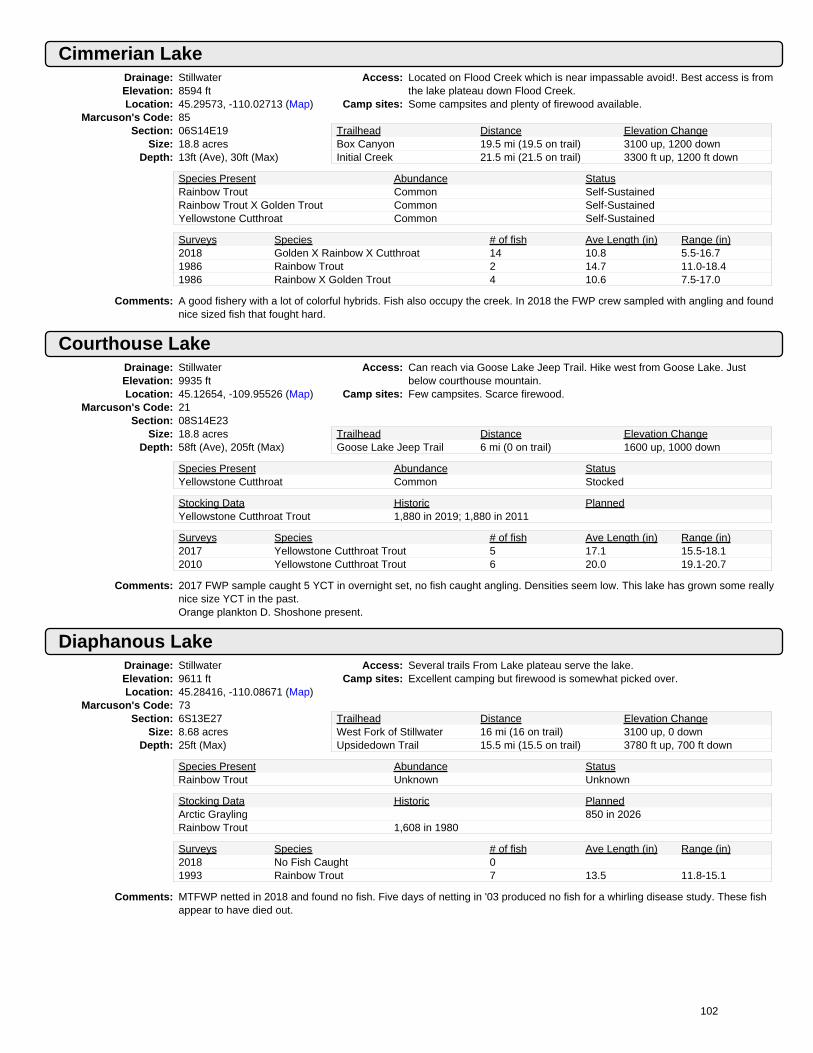
Cimmerian LakeDrainage: StillwaterElevation: 8594 ftLocation: 45.29573, -110.02713 (Map)
Marcuson's Code: 85Section: 06S14E19
Size: 18.8 acresDepth: 13ft (Ave), 30ft (Max)
Access: Located on Flood Creek which is near impassable avoid!. Best access is fromthe lake plateau down Flood Creek.
Camp sites: Some campsites and plenty of firewood available.
Trailhead Distance Elevation ChangeBox Canyon 19.5 mi (19.5 on trail) 3100 up, 1200 downInitial Creek 21.5 mi (21.5 on trail) 3300 ft up, 1200 ft down
Species Present Abundance StatusRainbow Trout Common Self-SustainedRainbow Trout X Golden Trout Common Self-SustainedYellowstone Cutthroat Common Self-Sustained
Surveys Species # of fish Ave Length (in) Range (in)2018 Golden X Rainbow X Cutthroat 14 10.8 5.5-16.71986 Rainbow Trout 2 14.7 11.0-18.41986 Rainbow X Golden Trout 4 10.6 7.5-17.0
Comments: A good fishery with a lot of colorful hybrids. Fish also occupy the creek. In 2018 the FWP crew sampled with angling and foundnice sized fish that fought hard.
Courthouse LakeDrainage: StillwaterElevation: 9935 ftLocation: 45.12654, -109.95526 (Map)
Marcuson's Code: 21Section: 08S14E23
Size: 18.8 acresDepth: 58ft (Ave), 205ft (Max)
Access: Can reach via Goose Lake Jeep Trail. Hike west from Goose Lake. Justbelow courthouse mountain.
Camp sites: Few campsites. Scarce firewood.
Trailhead Distance Elevation ChangeGoose Lake Jeep Trail 6 mi (0 on trail) 1600 up, 1000 down
Species Present Abundance StatusYellowstone Cutthroat Common Stocked
Stocking Data Historic PlannedYellowstone Cutthroat Trout 1,880 in 2019; 1,880 in 2011
Surveys Species # of fish Ave Length (in) Range (in)2017 Yellowstone Cutthroat Trout 5 17.1 15.5-18.12010 Yellowstone Cutthroat Trout 6 20.0 19.1-20.7
Comments: 2017 FWP sample caught 5 YCT in overnight set, no fish caught angling. Densities seem low. This lake has grown some reallynice size YCT in the past.Orange plankton D. Shoshone present.
Diaphanous LakeDrainage: StillwaterElevation: 9611 ftLocation: 45.28416, -110.08671 (Map)
Marcuson's Code: 73Section: 6S13E27
Size: 8.68 acresDepth: 25ft (Max)
Access: Several trails From Lake plateau serve the lake.Camp sites: Excellent camping but firewood is somewhat picked over.
Trailhead Distance Elevation ChangeWest Fork of Stillwater 16 mi (16 on trail) 3100 up, 0 downUpsidedown Trail 15.5 mi (15.5 on trail) 3780 ft up, 700 ft down
Species Present Abundance StatusRainbow Trout Unknown Unknown
Stocking Data Historic PlannedArctic Grayling 850 in 2026Rainbow Trout 1,608 in 1980
Surveys Species # of fish Ave Length (in) Range (in)2018 No Fish Caught 01993 Rainbow Trout 7 13.5 11.8-15.1
Comments: MTFWP netted in 2018 and found no fish. Five days of netting in '03 produced no fish for a whirling disease study. These fishappear to have died out.
102

Dreary LakeDrainage: StillwaterElevation: 9194 ftLocation: 45.27861, -110.06228 (Map)
Marcuson's Code: 88Section: 06S13E25
Size: 15.5 acresDepth: 5ft (Ave), 12ft (Max)
Access: Access best from the lake plateau. The lake is in the Flood Creek drainage. 4ways in - initial Creek/Woodbine/upsidedown Trail/box canyon. ( upsidedownor box canyon are best).
Camp sites: There are some camping spots. There is plenty of firewood.
Trailhead Distance Elevation ChangeInitial Creek 20 mi (20 on trail) 3100 up, 700 downBox Canyon Trail 19 mi (19 on trail) 3540 ft up, 1900 ft down
Species Present Abundance StatusRainbow Trout X Golden Trout Abundant Self-Sustained
Surveys Species # of fish Ave Length (in) Range (in)2018 No Fish Caught 02018 Rainbow Trout 16 10.7 7.1-15.61994 Rainbow Trout 16 8.5 6.4-12.91994 Rainbow X Golden Trout 2 7.2 6.8-7.5
Comments: Most fish look like Rainbows, some have Golden Trout characteristics. MTFWP crew netted the lake in 2018.
Dryad LakeDrainage: StillwaterElevation: 9194 ftLocation: 45.28501, -110.02473 (Map)
Marcuson's Code: 84Section: 06S14E30
Size: 5.1 acresDepth: 12ft (Ave), 45ft (Max)
Access: Access difficult. Headwaters of Flood Creek. Hike on trails to lake surrenderthen x-country southeast 1.5 miles.
Camp sites: Only a few flat spots (near inlet). Plenty of firewood.
Trailhead Distance Elevation ChangeWoodbine 12 mi (6 on trail) 4050 up, 0 downBox Canyon Trail 22 mi (20 on trail) 3500 ft up, 1100 ft down
Species Present Abundance StatusGolden Trout Common Stocked
Stocking Data Historic PlannedGolden Trout 510 in 2017; 510 in 2012 510 in 2023
Surveys Species # of fish Ave Length (in) Range (in)2018 Golden Trout 16 13.7 9.1-18.91994 Cutthroat X Golden Trout 15 9.8 6.2-15.01994 Rainbow X Golden Trout 1 15.5 15.5-15.5
Comments: 1440 gt's planted in '82, 765 in '91. The '91 plants were age 0 and 1 fish. '01 net set for 19.5 hours. Long hike from anywhere.Glen Owens 7/99 found no goldens.
Replant when possible. Decent food base, some shrimp and lots of aquatic insects. Nice Lake. No spawning potential in theoutlet - all large rocks 1 foot or better in diameter. Deep inlet stream has decent potential. It is sandy with some gravel.
'94 fish in good general health. Stomachs full of shrimp.
Favonius LakeDrainage: StillwaterElevation: 9505 ftLocation: 45.21864, -110.09625 (Map)
Marcuson's Code: 56Section: 07S13E15
Size: 25.5 acresDepth: 5ft (Ave), 15ft (Max)
Access: Trail #27 up e. Fork of the boulder Past Lake kathleen and up Rainbow Creek.Take the right fork, cross the creek to columbine pass then down.
Camp sites: Lots of campsites and firewood is available
Trailhead Distance Elevation ChangeBox Canyon 12.3 mi (12.3 on trail) 3300 up, 700 down
Species Present Abundance StatusYellowstone Cutthroat Common Self-Sustained
Surveys Species # of fish Ave Length (in) Range (in)2019 Yellowstone Cutthroat Trout 35 10.2 4.9-18.12008 Yellowstone Cutthroat Trout 9 12.0 8.0-16.1
Comments: Fish are obviously spawning successfully. FWP visited lake in 2016 but didn't catch enough fish for a sample. Did see redds ininlet. FWP sampled in 2019, fishing was good but gill net didn't catch many.
103

Fly LakeDrainage: StillwaterElevation: 9794 ftLocation: 45.11996, -109.96935 (Map)
Marcuson's Code: 25Section: 08S14E22
Size: 2.5 acresDepth: 17ft (Ave), 38ft (Max)
Access: Hike cross country from Goose Lake for 3 miles. One can drive to GooseLake with a 4x4 truck.
Camp sites: Good camping between Spider and Fly lakes, Adequate firewood. Little use.
Trailhead Distance Elevation ChangeGoose Lake Jeep Trail 5 mi (0 on trail) 1300 up, 1200 down
Species Present Abundance StatusBrook Trout Abundant Self-Sustained
Surveys Species # of fish Ave Length (in) Range (in)2017 Brook Trout 10 9.7 8.2-11.02010 Brook Trout 13 10.5 8.8-12.0
Comments: The 2010 and 2017 samples were obtained using angling. EB are quite easy to catch here.
Glacier Green Lake (Glacier Creek Lake)Drainage: StillwaterElevation: 9027 ftLocation: 45.14389, -109.92336 (Map)
Marcuson's Code: 17Section: 08S14E12
Size: 16.3 acresDepth: 20ft (Ave), 47ft (Max)
Access: Leave the end of the Goose Lake Jeep Trail and take trail around e. Side tolittle goose. Then x-country NW to incisor lake, then down the creek.
Camp sites: Firewood and campsites available.
Trailhead Distance Elevation ChangeGoose Lake Jeep Trail 4 mi (3 on trail) 240 up, 1200 down
Species Present Abundance StatusBrook Trout Abundant Self-Sustained
Stocking Data Historic PlannedCutthroat Trout 6,900 in 1937
Surveys Species # of fish Ave Length (in) Range (in)2017 Brook Trout 19 7.4 5.1-9.41995 Brook Trout 138 7.8 5.7-13.3
Comments: Overcrowded with brookies. Anglers should feel free to eat a fish supper here. 2017 FWP easily angled 19 EB in 40 min
Goose LakeDrainage: StillwaterElevation: 9945 ftLocation: 45.11735, -109.91315 (Map)
Marcuson's Code: 42Section: 08S15E19
Size: 102.0 acresDepth: 46ft (Ave), 130ft (Max)
Access: Goose Lake 4x4 Jeep Trail from cooke city. From the end of the jeep road,follow the hiking trail over the hill, north to Goose Lake 1/4 mile.
Camp sites: Many places to camp but firewood is scarce. Above tree line.
Trailhead Distance Elevation ChangeGoose Lake Jeep Trail .25 mi (.25 on trail) 50 up, 0 down
Species Present Abundance StatusYellowstone Cutthroat Abundant Self-Sustained
Surveys Species # of fish Ave Length (in) Range (in)2017 Yellowstone Cutthroat Trout 10 9.3 5.6-11.41998 Yellowstone Cutthroat Trout 29 8.7 4.9-11.2
Comments: 2017 sample obtained with angling. Fish condition tends to be thin to average. The lake receives a fair amount of use.
104

Huckleberry LakeDrainage: StillwaterElevation: 9591 ftLocation: 45.08756, -109.92405 (Map)
Marcuson's Code: 46Section: 08S14E36
Size: 15.3 acresDepth: 17ft (Ave), 49ft (Max)
Access: Short 1 mile cross country hike from Goose Lake Jeep Trail.Camp sites: There are some flat spots to camp and some firewood is nearby.
Trailhead Distance Elevation ChangeGoose Lake Jeep Trail .5 mi (0 on trail) 160 up, 160 down
Species Present Abundance StatusYellowstone Cutthroat Abundant Unknown
Stocking Data Historic PlannedRainbow Trout 3,570 in 1949Yellowstone Cutthroat Trout 1,000 in 2020; 2,300 in 2011
Surveys Species # of fish Ave Length (in) Range (in)2020 Yellowstone Cutthroat Trout 7 13.0 8.3-16.02018 Yellowstone Cutthroat Trout 26 13.3 7.3-17.0
Comments: MTFWP completed a rotenone project to remove brook trout in 2007 and 2008. There were 200 8-inch YCT planted in 2009.Fingerlings were planted in 2009-2011 to establish self sustaining population. MTFWP sampled in 2018 with netting andangling. The YCT appear to be self-sustaining now and are growing to nice sizes.
Imelda LakeDrainage: StillwaterElevation: 9804 ftLocation: 45.16618, -109.91183 (Map)
Marcuson's Code: 13Section: 08S15E6
Size: 32.4 acresDepth: 26ft (Ave), 75ft (Max)
Access: From Lake abundance Take Trail #24 down the Stillwater to Clarks Creekopposite horseshoe creek test Trail #34. Difficult 4 mile x-country up ClarksCreek.
Camp sites: Rocky terrain provides marginal camping. Firewood scarce.
Trailhead Distance Elevation ChangeLake Abundance 14 mi (10 on trail) 2800 up, 1600 downWoodbine 19.9 mi (15.2 on trail) 4500 ft up, 0 ft down
Species Present Abundance StatusBrook Trout Abundant Self-Sustained
Surveys Species # of fish Ave Length (in) Range (in)1995 Brook Trout 62 7.6 6.2-9.01975 Brook Trout 35 8.4 6.0-10.3
Comments: Any route you choose to this lake it is a ball buster. A. Hag. Agrees '95. Only fair spawning potential in inlet but the brookiesmake the most of it.
Greg Aldrich reports lots of small EB's up to 10" 8/92. '95 - fish were in average condition.
Incisor LakeDrainage: StillwaterElevation: 9699 ftLocation: 45.13457, -109.91323 (Map)
Marcuson's Code: 18Section: 08S15E18
Size: 5.9 acresDepth: 14ft (Ave), 32ft (Max)
Access: No Trail. Best access is from Goose Lake via the Goose Lake jeep trail.Camp sites: Few campsites. Some firewood.
Trailhead Distance Elevation ChangeGoose Lake Jeep Trail 3 mi (2 on trail) 240 up, 440 down
Species Present Abundance StatusGolden Trout Abundant Stock, with some natural reproduction
Stocking Data Historic PlannedGolden Trout 3,000 in 2017; 1,000 in 2011 1,180 in 2023
Surveys Species # of fish Ave Length (in) Range (in)2017 Golden Trout 22 12.4 7.2-16.82010 Golden Trout 34 8.9 5.9-16.5
Comments: 2017 fish were in great condition, bright orange flesh, looks like some reproduction. Good spawning area in the outlet. One 10"fish seen in '00, none in net. Outlet goes underground before reaching Glacier Creek lake.Fish were seen attempting to spawn in the outlet stream.
105

Jasper Lake (Tumble Lake)Drainage: StillwaterElevation: 9184 ftLocation: 45.34573, -110.04104 (Map)
Marcuson's Code: 100Section: 6S14E6
Size: 34.16 acresDepth: 15ft (Ave), 77ft (Max)
Access: No Trail exists from Trail #90 on the west fork of the Stillwater. Follow Eastside of Tumble Creek. It's a steep climb,large boulders and deadfall.
Camp sites: Nice campsite, plenty of firewood.
Trailhead Distance Elevation ChangeInitial Creek 6.5 mi (4 on trail) 2600 up, 100 downW.F.Stillwater None mi (None on trail) None ft up, None ft down
Species Present Abundance StatusYellowstone Cutthroat Common Self-Sustained
Stocking Data Historic PlannedYellowstone Cutthroat Trout 5,000 in 1977; 5,074 in 1968
Surveys Species # of fish Ave Length (in) Range (in)2013 Yellowstone Cutthroat Trout 22 10.8 6.4-14.62003 Yellowstone Cutthroat Trout 8 13.1 11.5-14.5
Comments: Lake is also referred to as tumble lake. There are also YCT in the upper lake.
The 2003 sample was obtained by angling.
Jay LakeDrainage: StillwaterElevation: 9794 ftLocation: 45.30673, -110.06669 (Map)
Marcuson's Code: 93Section: 06S13E14
Size: 23.7 acresDepth: 35ft (Max)
Access: Best access is from the Boulder lake plateau. The lake is in the Flood Creekdrainage which is basically impassable.
Camp sites: Unsheltered area. Lots of flat spots. Some firewood .
Trailhead Distance Elevation ChangeWoodbine 15 mi (6 on trail) 4530 up, 0 downW.F.Stillwater 22 mi (19.5 on trail) 4200 ft up, 1000 ft down
Species Present Abundance StatusYellowstone Cutthroat Common Self-Sustained
Stocking Data Historic PlannedLargemouth Bass 5,000 in 1988Yellowstone Cutthroat Trout 2,300 in 1977
Surveys Species # of fish Ave Length (in) Range (in)2018 Yellowstone Cutthroat Trout 22 14.4 7.2-16.92005 Yellowstone Cutthroat Trout 14 13.4 9.3-15.5
Comments: Jay Lake as planted in '77 with Yellowstone cutthroat and is now self-sustaining. MTFWP crew netted and angled in 2018.Some of the larger fish were a little thin but most were in good shape.
Jeff LakeDrainage: StillwaterElevation: 9220 ftLocation: 45.08959, -109.93605 (Map)
Marcuson's Code: 48Section: 08S14E36
Size: 1.3 acresDepth: 4ft (Max)
Access: Accessible from the Goose Lake Jeep Trail. Outside of the a-b wilderness.Camp sites: Some firewood and campsites available.
Trailhead Distance Elevation ChangeGoose Lake Jeep Trail 2 mi (1 on trail) 0 up, 640 down
Species Present Abundance StatusYellowstone Cutthroat Abundant Unknown
Stocking Data Historic PlannedYellowstone Cutthroat Trout 300 in 2020; 325 in 2011
Surveys Species # of fish Ave Length (in) Range (in)2020 Yellowstone Cutthroat Trout 1 11.3 11.3-11.32013 Yellowstone Cutthroat Trout 11 10.8 7.9-12.7
Comments: Rotenone project to remove brook trout in 2007 and 2008. YCT planted in 2009 and 2010.
Jeff Lake has a good inlet flow most of which comes from sheep mtn. The outlet drops ~60 ft and flows into Mutt Lake.
Numerous YCT observed in 2010. The 2013 sample was obtained using angling for 2 hours.
106

Jordan LakeDrainage: StillwaterElevation: 8925 ftLocation: 45.23507, -110.07757 (Map)
Marcuson's Code: 62Section: 07S13E11
Size: 14.7 acresDepth: 17ft (Ave), 35ft (Max)
Access: Trail #27 e fork of main boulder-l kathleen-rainbow cr-l columbine-columbinepass-between favonius test pentad, then 2 miles down test up to jordan.
Camp sites: Some campsites along the east shore with plenty of firewood.
Trailhead Distance Elevation ChangeBox Canyon 14 mi (14 on trail) 3400 up, 1400 down
Species Present Abundance StatusYellowstone Cutthroat Common Self-Sustained
Surveys Species # of fish Ave Length (in) Range (in)2016 Yellowstone Cutthroat Trout 16 10.3 8.2-12.62008 Yellowstone Cutthroat Trout 14 9.5 6.6-12.3
Comments: In 1969 it was felt this lake needed increased harvest and it seemed to be a well used lake. Not much has changed. There arestill plenty of cutts that are a bit on the thin side and there is still evidence of use.
Lake AriesDrainage: StillwaterElevation: 9547 ftLocation: 45.11244, -109.96653 (Map)
Marcuson's Code: 29Section: 8S14E27
Size: 6.0 acresDepth: 32ft (Max)
Access: Hike cross country from Goose Lake. One can reach Goose Lake with a 4x4truck or hike NE from beauty lake.
Camp sites: Camping is fair, some firewood. Little sign of '88 fire.
Trailhead Distance Elevation ChangeGoose Lake Jeep Trail 4.5 mi (0 on trail) 1000 up, 1200 down
Species Present Abundance StatusBrook Trout Abundant Self-Sustained
Surveys Species # of fish Ave Length (in) Range (in)2017 Brook Trout 10 8.5 7.5-9.52013 Brook Trout 19 7.5 5.1-8.9
Comments: No additional management suggested. Little use.The 2017 sample was obtained with 2 anglers for 15 minutes. Brook Trout were eager to eat a fly
Lake Of The WoodsDrainage: StillwaterElevation: 8784 ftLocation: 45.16151, -110.04532 (Map)
Marcuson's Code: 49Section: 08S13E1
Size: 7.9 acresDepth: 6ft (Ave), 16ft (Max)
Access: Take Trail #24 down the Stillwater from the lake abundance trailhead. AtHorseshoe Creek Take Trail #34 to lake of the woods.
Camp sites: Many campsites, plenty of firewood. Area is burned only a few live trees.
Trailhead Distance Elevation ChangeLake Abundance 13 mi (13 on trail) 1700 up, 1500 downIndependence 16 mi (16 on trail) 3400 ft up, 1000 ft down
Species Present Abundance StatusYellowstone Cutthroat Abundant Self-Sustained
Surveys Species # of fish Ave Length (in) Range (in)2012 Yellowstone Cutthroat Trout 38 8.6 4.5-12.41995 Yellowstone Cutthroat Trout 32 9.3 4.5-15.3
Comments: No stocking record exists for Lake of the Woods, fish may have been transplanted from Peace and Heather Lakes. In 2012MTFWP crew caught 38 YCT in a 12.5 hr net set. The entire shoreline is burned.
107

Lake PinchotDrainage: StillwaterElevation: 9332 ftLocation: 45.27921, -110.07191 (Map)
Marcuson's Code: 91Section: 06S13E26
Size: 53.9 acresDepth: 12ft (Ave), 30ft (Max)
Access: Best access is from the lake plateau. Avoid the Flood Creek drainage like theplague! Basically impassable!
Camp sites: Excellent camping, lots of Firewood. Lake receives a lot of use.
Trailhead Distance Elevation ChangeUpsidedown Creek 16 mi (16 on trail) 3750 up, 1000 downBox Canyon 18 mi (18 on trail) 2950 ft up, 400 ft down
Species Present Abundance StatusRainbow Trout X Golden Trout Common Self-Sustained
Surveys Species # of fish Ave Length (in) Range (in)2018 Rainbow Trout 11 13.3 11.0-15.51993 Rainbow Trout 7 12.3 10.8-14.51993 Rainbow X Cutthroat Trout 12 11.5 6.4-14.8
Comments: Lake Pinchot is a popular place with signs of horse use.The origin of the Rainbows is not known. Spawning success is evident.MTFWP sampled in 2018 with angling. They caught Rainbows from 11-15 inches that fought hard.
Lake SurrenderDrainage: StillwaterElevation: 8728 ftLocation: 45.29602, -110.03597 (Map)
Marcuson's Code: 86Section: 06S14E19
Size: 9.1 acresDepth: 13ft (Ave), 40ft (Max)
Access: Best access is from the lake plateau. The lake is in the Flood Creek drainagewhich is basically impassable. There is intermittent trail from Lake Pinchot.
Camp sites: Camping is best near the inlet. There is plenty of firewood.
Trailhead Distance Elevation ChangeBox Canyon 19 mi (19 on trail) 3100 up, 1100 downWest Stillwater 21 mi (21 on trail) 3300 ft up, 1200 ft down
Species Present Abundance StatusCutthroat Hybrid Common Self-SustainedRainbow Trout Hybrid Common Self-Sustained
Surveys Species # of fish Ave Length (in) Range (in)2018 Golden X Rainbow X Cutthroat 12 12.0 8.5-14.92018 Rainbow Trout 3 6.0 3.3-8.91997 Cutthroat X Golden Trout 2 9.6 8.1-11.01997 Rainbow X Golden Trout 2 9.0 8.0-10.0
Comments: Access is both long and difficult. The lake is full of colorful hybrids, CTXRBXGT and everything in between. The mountainlakes crew sampled with netting and angling in 2018.
Lake WildernessDrainage: StillwaterElevation: 9581 ftLocation: 45.27921, -109.84082 (Map)
Marcuson's Code: 2Section: 06S15E27
Size: 19.0 acresDepth: 40ft (Ave), 120ft (Max)
Access: If going up Woodbine Creek, downfall and thick lodgepole. Best to crossstillwater plateau from near the benbow mine. Partial Trails.
Camp sites: Many campsites. Firewood is available.
Trailhead Distance Elevation ChangeNear Chrome Lake 7 mi (2 on trail) 1500 up, 1100 down
Species Present Abundance StatusYellowstone Cutthroat Common Self-Sustained
Stocking Data Historic PlannedYellowstone Cutthroat Trout 3,000 in 1984; 540 in 1976
Surveys Species # of fish Ave Length (in) Range (in)2020 Yellowstone Cutthroat Trout 34 13.5 11.8-16.52013 Yellowstone Cutthroat Trout 14 14.7 10.0-16.0
Comments: Good spawning area in outlet.
The 2013 sample was obtained using angling.
108

Lightning LakeDrainage: StillwaterElevation: 9394 ftLocation: 45.33387, -110.07004 (Map)
Marcuson's Code: 102Section: 06S13E2
Size: 61.3 acresDepth: 44ft (Ave), 122ft (Max)
Access: Up Trail #90 from Initial Creek to east side of tumble creek or east side oflightning creek. May be best from near mouth of divide creek.
Camp sites: Nice sites. Plenty of wood but picked over between lakes.
Trailhead Distance Elevation ChangeInitial Creek 9.5 mi (5 on trail) 2950 up, 200 downLake Plateau 20 mi (15 on trail) 2700 ft up, 500 ft down
Species Present Abundance StatusGolden Trout Common Self-Sustained
Stocking Data Historic PlannedGolden Trout 10,310 in 1956
Surveys Species # of fish Ave Length (in) Range (in)2013 Golden Trout 36 10.7 6.3-19.82003 Golden Trout 16 9.4 6.9-16.3
Comments: Fish were progeny of Sylvan Lake stock. Goldens spawn in the outlet. Offspring spend time in Little Lightning, then move backinto Lightning.
Muliple fire rings. Heavy use. The 2003 sample was obtained using angling.
Little Goose LakeDrainage: StillwaterElevation: 9984 ftLocation: 45.12609, -109.90624 (Map)
Marcuson's Code: 43Section: 08S15E19
Size: 8.1 acresDepth: 9ft (Ave), 23ft (Max)
Access: Hike 1 mile up Goose Creek from Goose Lake. One can reach Goose Lakewith a 4x4 vehicle.
Camp sites: Firewood scarce.some flat spots to camp
Trailhead Distance Elevation ChangeGoose Lake Jeep Trail 1.5 mi (1.5 on trail) 100 up, 0 down
Species Present Abundance StatusYellowstone Cutthroat Abundant Self-Sustained
Surveys Species # of fish Ave Length (in) Range (in)2017 Yellowstone Cutthroat Trout 11 9.4 7.8-12.22000 Yellowstone Cutthroat Trout 15 11.1 7.8-13.9
Comments: No planting records. Fish may have come from the clarks fork river.Reproduction is occuring at a healthy rate. Monitor periodically. 2017 sample was angled in 1.5 hours. YCT were a little morepicky than usual
Little Lightning LakeDrainage: StillwaterElevation: 9391 ftLocation: 45.33857, -110.0667 (Map)
Marcuson's Code: 102Section: 06S13E2
Size: 13.8601 acresDepth: 12ft (Ave), 12ft (Max)
Access: Up Trail #90 from Initial Creek to east side of tumble creek or east side oflightning creek. May be best from near mouth of Divide Creek.
Camp sites: Nice places to camp but firewood is picked over between lakes.
Trailhead Distance Elevation ChangeInitial Creek 9.25 mi (5 on trail) 2900 up, 200 downLake Plateau None mi (None on trail) None ft up, None ft down
Species Present Abundance StatusGolden Trout Abundant Self-Sustained
Surveys Species # of fish Ave Length (in) Range (in)2013 Golden Trout 14 9.0 6.9-15.11995 Golden Trout 41 9.0 5.8-16.1
Comments: Fish from Lightning Lake spawn in the outlet. Emerging fry drift into Little Lightning. Over time some of these movr back intoLightning.
The 2003 sample was obtained by angling.
109

Martes LakeDrainage: StillwaterElevation: 9433 ftLocation: 45.24986, -110.08505 (Map)
Marcuson's Code: 65Section: 07S13E3
Size: 17.5 acresDepth: 33ft (Max)
Access: Accessed from box Canyon Trail, upsidedown trail, or Woodbine trail the lakeis north of the middle fork of wounded Man Creek.
Camp sites: Some good camp spots at East end of the lake with plenty of fuel.
Trailhead Distance Elevation ChangeBox Canyon Trail #27 18.5 mi (18 on trail) 3600 up, 900 downWoodbine 19.5 mi (19 on trail) 4200 ft up, 0 ft down
Species Present Abundance StatusYellowstone Cutthroat Common Stocked
Stocking Data Historic PlannedYellowstone Cutthroat Trout 875 in 2019; 875 in 2011
Surveys Species # of fish Ave Length (in) Range (in)2019 Yellowstone Cutthroat Trout 3 16.6 14.0-18.12009 Yellowstone Cutthroat Trout 22 14.0 12.4-15.0
Comments: Martes lake usually produces large fish. Plant numbers were cut to 50/acre in 1995 to boost growth rates. The 2019 surveyfound low numbers of decent sized YCT.
Mountain View LakeDrainage: StillwaterElevation: 6986 ftLocation: 45.3872, -109.90144 (Map)
Marcuson's Code: NoneSection: 05S15E20
Size: 3.7201 acresDepth: 6ft (Ave), 13ft (Max)
Access: Can be accessed by hiking up Mountain View Creek from the road aboveStillwater mine settling ponds. It is quite steep at the start with some old roadbeds helping near the end. Use care to stay on NFS property. Can also beaccessed from the Rabbit Gulch trail.
Camp sites:
Trailhead Distance Elevation ChangeRoad 2486 1.5 mi (NO on trail) 1500 up, 0 downRabbit Gulch 4.5 mi (3 on trail) None ft up, None ft down
Species Present Abundance StatusBrook Trout Unknown UnknownWhite Sucker Abundant Self-Sustained
Surveys Species # of fish Ave Length (in) Range (in)2018 Brook Trout 5 9.6 8.5-10.72018 Lake Chub 1 5.1 5.1-5.12009 Brook Trout 10 11.2 8.8-16.32009 White Sucker 6 9.5 7.3-14.8
Comments: The lake is outside of the A-B wilderness on Forest Service land. There is decent fishing for some nice size brook trout. WhiteSuckers and Lake Chubs are also present.
Mouse LakeDrainage: StillwaterElevation: 9581 ftLocation: 45.20954, -110.09527 (Map)
Marcuson's Code: 55Section: 07S13E22
Size: 6.9 acresDepth: 13ft (Ave), 30ft (Max)
Access: Trail #27 up east fork of main boulder-lake Kathleen-rainbow Creek-lakecolumbine-columbine pass. Then around unnamed lake to east then se.
Camp sites: There are flat areas (rocky) near the lake with firewood.
Trailhead Distance Elevation ChangeBox Canyon 13.5 mi (12.5 on trail) 3650 up, 500 downWoodbine 22.5 mi (21.5 on trail) 3850 ft up, 0 ft down
Species Present Abundance StatusYellowstone Cutthroat Abundant Stock, with some natural reproduction
Stocking Data Historic PlannedYellowstone Cutthroat Trout 345 in 2016; 300 in 2008 345 in 2024
Surveys Species # of fish Ave Length (in) Range (in)2016 Yellowstone Cutthroat Trout 11 13.9 11.7-16.92008 Yellowstone Cutthroat Trout 16 14.8 12.4-16.1
Comments: Mostly frozen and snowing early July 2010. K. Latterell and B. Lesher observed one 12-13" fish. 2016 FWP sample 4 hr net set13-15 inch YCT looked fat and healthy.
110

Mutt LakeDrainage: StillwaterElevation: 9194 ftLocation: 45.09194, -109.93686 (Map)
Marcuson's Code: 47Section: 08S14E36
Size: 1.5 acresDepth: 4ft (Max)
Access: Mutt is accessible from the Goose Lake Jeep Trail. Outside the a-bwilderness.
Camp sites: Some campsites. Scarce firewood.
Trailhead Distance Elevation ChangeGoose Lake Jeep Trail 2 mi (1 on trail) 0 up, 640 down
Species Present Abundance StatusYellowstone Cutthroat Common Unknown
Surveys Species # of fish Ave Length (in) Range (in)2020 Yellowstone Cutthroat Trout 22 8.5 7.2-10.72013 Yellowstone Cutthroat Trout 18 8.1 3.3-10.7
Comments: Rotenone project to remove brook trout from 2007-2009. Outlet flows into Goose Creek which has excellent spawning graveland permanent flows. Fish can probably move between Goose Creek and the lake at high flows.
The inlet stream from Jeff Lake has excellent spawning gravel and flow. In the 2013 survey 13 of the 18 sampled fish weresampled using angling.
Owl LakeDrainage: StillwaterElevation: 9594 ftLocation: 45.27554, -110.09905 (Map)
Marcuson's Code: 71Section: 06S13E27
Size: 14.4 acresDepth: 13ft (Ave), 30ft (Max)
Access: Approximately 12 Trail miles from the trailhead on the west fork of theStillwater.
Camp sites: There are some good places to camp. Firewood nearby.
Trailhead Distance Elevation ChangeUpsidedown Trail 14 mi (14 on trail) 3700 up, 700 down
Species Present Abundance StatusYellowstone Cutthroat Trout X Rainbow Common Self-Sustained
Surveys Species # of fish Ave Length (in) Range (in)2018 Rainbow Trout 7 13.9 10.0-19.52003 Rainbow Trout 15 11.5 9.5-13.2
Comments: The fish in Owl Lake look like pure Rainbows. MTFWP crew angled 7 RB from 10-19 inches in 2018. The fish were in goodshape and fought hard.
Pentad LakeDrainage: StillwaterElevation: 9394 ftLocation: 45.22433, -110.10127 (Map)
Marcuson's Code: 59Section: 07S13E15
Size: 40.7 acresDepth: 24ft (Ave), 58ft (Max)
Access: Trail #27 up east fork of main boulder-lake Kathleen-rainbow Creek-lakecolumbine-columbine pass. Then downhill to favonius and pentad lakes.
Camp sites: Plenty of campsites but firewood is a little picked over.
Trailhead Distance Elevation ChangeBox Canyon 12.5 mi (12.5 on trail) 3300 up, 700 down
Species Present Abundance StatusYellowstone Cutthroat Abundant Self-Sustained
Surveys Species # of fish Ave Length (in) Range (in)2016 Yellowstone Cutthroat Trout 10 10.9 8.9-13.12008 Yellowstone Cutthroat Trout 9 9.6 6.5-11.7
Comments: Origin of these fish unknown. Natural reproduction occuring. There is interaction with Favonius Lake upstream.Surveyed 2016 with angling, fish in average shape.
111

Picket Pin Lake, NorthDrainage: StillwaterElevation: 8826 ftLocation: 45.43079, -110.0402 (Map)
Marcuson's Code: 105Section: 05S14E6
Size: 5.3 acresDepth: 10ft (Ave), 20ft (Max)
Access: Picket pin 4x4 road #140 from the West Fork Stillwater River. Access road tolake is not marked but head east just before the Brass Monkey Mine.
Camp sites: Many campsites and lots of firewood available.
Trailhead Distance Elevation ChangePicket Pin Road 0 mi (0 on trail) 0 up, 0 down
Species Present Abundance StatusYellowstone Cutthroat Common Stocked
Stocking Data Historic PlannedYellowstone Cutthroat Trout 1,250 in 2020; 1,060 in 2018 1,060 in 2021; 1,060 in 2023
Surveys Species # of fish Ave Length (in) Range (in)2015 Yellowstone Cutthroat Trout 5 14.8 10.6-19.91998 Yellowstone Cutthroat Trout 2 16.1 14.9-17.3
Comments: The lake receives a lot of angling pressure because of its accessibility.
Stocked every 4 years. A poor net set during the 2015 survey is suspected to be the culprit for the low catch rates. YellowstoneCutthroat Trout abundance is likely higher than the 2015 net sampling suggests.
One of the 4 fish sample in 2015 was collected with 0.75 hrs of angling.
Picket Pin Lake, SouthDrainage: StillwaterElevation: 9099 ftLocation: 45.42663, -110.04614 (Map)
Marcuson's Code: 104Section: 05S14E6
Size: 5.0 acresDepth: 8ft (Ave), 19ft (Max)
Access: Picket pin 4x4 road #140 from the West Fork Stillwater River. Access road toPicket Pin Lakes is not marked but head east just before the Brass MonkeyMine.
Camp sites: Many campsites. Lots of firewood available.
Trailhead Distance Elevation ChangePicket Pin Road 0 mi (0 on trail) 0 up, 0 down
Species Present Abundance StatusYellowstone Cutthroat Common Stocked
Stocking Data Historic PlannedYellowstone Cutthroat Trout 1,060 in 2020; 625 in 2019 1,250 in 2021; 1,250 in 2023
Surveys Species # of fish Ave Length (in) Range (in)2019 Yellowstone Cutthroat Trout 1 11.3 11.3-11.32015 Yellowstone Cutthroat Trout 24 10.4 6.4-14.4
Comments: The lake receives a fair amount of angling pressure because of its accessibility. Most of the shoreline is vegetated marsh land.
Changed stock frequency from 4 to 2 years starting in 2019.
Pipit LakeDrainage: StillwaterElevation: 9594 ftLocation: 45.27292, -110.10462 (Map)
Marcuson's Code: 70Section: 06S13E33
Size: 7.0 acresDepth: 12ft (Ave), 25ft (Max)
Access: Access is served by Several Trails to the lake plateau between the boulderand stillwater drainages.
Camp sites: Nice places to camp. Plenty of firewood.
Trailhead Distance Elevation ChangeUpsidedown Trail 14 mi (14 on trail) 3700 up, 700 down
Species Present Abundance StatusYellowstone Cutthroat Trout X Rainbow Common Self-Sustained
Surveys Species # of fish Ave Length (in) Range (in)2016 Rainbow Trout 8 9.5 5.4-11.32007 Rainbow Trout 7 9.8 7.0-11.3
Comments: Excellent Trail all the way to Pipit Lake. The origin of the fish is unknown. FWP sample in 2016 fat healthy looking RB. Looklike pure RB no sign of CT. Fwp sampled 07,6.5 hour set+angling,fat fish.
112

Raven LakeDrainage: StillwaterElevation: 8994 ftLocation: 45.28826, -110.05392 (Map)
Marcuson's Code: 87Section: 06S13E25
Size: 10.0 acresDepth: 46ft (Max)
Access: Best access is from the lake plateau. The lake is in the Flood Creek drainagewhich is basically impassable. From wounded man follow a Poor Trail pastpinchot.
Camp sites: Nice campsites with plenty of firewood available.
Trailhead Distance Elevation ChangeBox Canyon 18 mi (18 on trail) 3300 up, 800 downWest Stillwater 20 mi (20 on trail) 3300 ft up, 900 ft down
Species Present Abundance StatusCutthroat Hybrid Common Self-SustainedRainbow Trout Hybrid Common Self-Sustained
Surveys Species # of fish Ave Length (in) Range (in)2018 Golden X Rainbow X Cutthroat 9 10.3 6.8-12.21997 Cutthroat X Golden Trout 3 9.0 5.8-10.71997 Rainbow X Golden Trout 4 9.0 6.3-11.2
Comments: Colorful hybrids. Access is long and difficult. FWP sampled in 2018 with hook and line.
Saderbalm Lake (Sodderholm Lake)Drainage: StillwaterElevation: 9020 ftLocation: 45.34274, -110.01671 (Map)
Marcuson's Code: 98Section: 06S14E5
Size: 7.4 acresDepth: 8ft (Ave), 29ft (Max)
Access: Hike up Saderbalm Creek, a tributary of the west fork of the Stillwater. NoTrail exists from #90 on the west fork.
Camp sites: No campsites. Lots of firewood.
Trailhead Distance Elevation ChangeInitial Creek 6 mi (2 on trail) 2400 up, 0 downHorseman Flats 9 mi (7 on trail) 3600 ft up, 900 ft down
Species Present Abundance StatusArctic Grayling Unknown Stocked
Stocking Data Historic PlannedArctic Grayling 400 in 2015; 775 in 1997 740 in 2023
Surveys Species # of fish Ave Length (in) Range (in)1990 No Fish Caught 0
Comments: This lake And Creek are called sodderholm on old forest service maps and in marcusons original files. Good food supply.Spawning potential in outlet. 2009 plant depends on avaiability.
The 500 grayling planted in 1985 did not take. '90 gill net set for 2.5 hours by volunteer crew. This is a Tough Lake to get to.Tom mcgillvray fished for ~1.5 hours in '94. Saw no sign of fish. Lake appeared to have lots of food. Very pretty spot.
Grayling will be put on an eight year schedule starting in 2009.
Sioux Charley LakeDrainage: StillwaterElevation: 5796 ftLocation: 45.331, -109.93292 (Map)
Marcuson's Code: 7Section: 06S14E12
Size: 3.6 acresDepth: 1ft (Ave), 4ft (Max)
Access: An easy 3 miles from the trailhead at Woodbine campground on the Stillwaterriver. Great trail.
Camp sites: Many places to camp but firewood is picked over.
Trailhead Distance Elevation ChangeWoodbine 3 mi (3 on trail) 350 up, 50 down
Species Present Abundance StatusBrook Trout Abundant Self-SustainedRainbow Trout Rare Self-Sustained
Stocking Data Historic PlannedCutthroat Trout 7,365 in 1947; 5,000 in 1941Rainbow Trout 2,750 in 1951; 29,460 in 1949
Surveys Species # of fish Ave Length (in) Range (in)1996 Brook Trout 27 7.9 5.4-9.71974 Brook Trout 32 7.8 5.3-10.21974 Yellowstone Cutthroat Trout 1 7.5 7.5-7.5
Comments: No additional management needed. CT's planted '31, '37, '40, '41. Rb's in '33, '34, '36, '40, '48, '49.
'96 fish were in average condition. '89 creel cards - 188 eb <8-12", 1 >16". 56 RB <8-12", 3 12-16" range. 4 CT <8".
113

Sourdough LakeDrainage: StillwaterElevation: 9584 ftLocation: 45.11441, -109.96769 (Map)
Marcuson's Code: 24Section: 08S14E22
Size: 2.6 acresDepth: 10ft (Ave), 22ft (Max)
Access: Best access is from Goose Lake via the Goose Lake Jeep Trail. From GooseLake hike cross country 3 miles west.
Camp sites: Camping is fair but not much firewood. No evidence of '88 fire
Trailhead Distance Elevation ChangeGoose Lake Jeep Trail 4.5 mi (0 on trail) 1000 up, 1200 down
Species Present Abundance StatusBrook Trout Abundant Self-Sustained
Stocking Data Historic PlannedYellowstone Cutthroat Trout 1,000 in 1967
Surveys Species # of fish Ave Length (in) Range (in)2017 Brook Trout 10 8.6 6.2-9.71999 Brook Trout 10 8.4 6.1-10.2
Comments: EB are very vulnerable to angling. 2017 sample with angling only. Caught 10 EB in 20 minutes.
Spider LakeDrainage: StillwaterElevation: 9794 ftLocation: 45.11887, -109.96516 (Map)
Marcuson's Code: 26Section: 08S14E22
Size: 6.3 acresDepth: 25ft (Ave), 28ft (Max)
Access: Hike 3 miles cross country from Goose Lake. One can drive to Goose Lakewith a 4x4 truck. NE of sourdough lake.
Camp sites: A few rocky camp spots. Little firewood. No sign of '88 fire.
Trailhead Distance Elevation ChangeGoose Lake Jeep Trail 5 mi (0 on trail) 1300 up, 1200 down
Species Present Abundance StatusBrook Trout Abundant Self-Sustained
Surveys Species # of fish Ave Length (in) Range (in)2017 Brook Trout 9 8.2 6.2-9.32010 Brook Trout 20 8.2 6.7-10.2
Comments: Lake is overcrowded with fish and has little fishing pressure. 2017 FWP sampled 9 EB with 30 minutes of angling. Lake coulduse some harvest
Sundown LakeDrainage: StillwaterElevation: 9584 ftLocation: 45.23305, -110.10255 (Map)
Marcuson's Code: 61Section: 07S13E10
Size: 5.2 acresDepth:
Access: Box Canyon Trail - columbine pass from the boulder 16 miles or fromWoodbine up stillwater and wounded man 21 miles.
Camp sites: Excellent campsite with firewood. Beautiful Lake.
Trailhead Distance Elevation ChangeBox Canyon 16 mi (15 on trail) 3500 up, 500 downWoodbine 21 mi (20 on trail) 3700 ft up, 0 ft down
Species Present Abundance StatusYellowstone Cutthroat Common Stocked
Stocking Data Historic PlannedWestslope Cutthroat Trout 900 in 2012; 1,216 in 2011Yellowstone Cutthroat Trout 520 in 2019; 520 in 2011
Surveys Species # of fish Ave Length (in) Range (in)2016 Yellowstone Cutthroat Trout 16 13.2 11.9-14.42009 Yellowstone Cutthroat Trout 1 19.6 19.6-19.6
Comments: 2016 FWP sampled with netting and angling. Caught some nice YCT but not the big ones this lake has produced in the past.Although there is No Trail, horses can access the lake (and have).
114

Sunken Rock LakeDrainage: StillwaterElevation: 9597 ftLocation: 45.24581, -110.09089 (Map)
Marcuson's Code: 64Section: 07S13E3
Size: 11.0 acresDepth: 30ft (Max)
Access: Trail #27 e fork of main boulder-l Kathleen-rainbow Creek-lcolumbine-columbine pass-between favonius test pentad-e side JordanLake-up inlet then west.
Camp sites: Beautiful place to camp. Plenty of firewood.
Trailhead Distance Elevation ChangeBox Canyon Trail 15.5 mi (14.5 on trail) 3700 up, 1400 downWoodbine 20 mi (19 on trail) 4275 ft up, 0 ft down
Species Present Abundance StatusGolden Trout Common Stocked
Stocking Data Historic PlannedGolden Trout 1,100 in 2017; 1,000 in 2011 1,100 in 2023Yellowstone Cutthroat Trout 4,050 in 1969
Surveys Species # of fish Ave Length (in) Range (in)2016 Golden Trout 33 13.2 6.8-18.52008 Golden Trout 35 12.5 9.7-15.4
Comments: YCT were not doing well so golden trout planted in '84. Some reproduction may be occurring. Saw a couple size classes in2016 and 2008 samples. GT are self sustaining in the pond below. GT seem to be a little more vulnerable to angling here thanin some other GT lakes.
Unnamed 69Drainage: StillwaterElevation: 9592 ftLocation: 45.2698, -110.1018 (Map)
Marcuson's Code: NoneSection: 6S13E34
Size: 2.4432 acresDepth:
Access: The lake is on the main trail between Pipit and Wounded Man LakesCamp sites: There are campsites and firewood available.
Trailhead Distance Elevation ChangeBox Canyon 14 mi (14 on trail) 3700 up, 750 down
Species Present Abundance StatusRainbow Trout Common Self-Sustained
Surveys Species # of fish Ave Length (in) Range (in)2019 Rainbow Trout 8 7.8 6.5-9.51984 Rainbow Trout 5 8.4 5.6-13.0
Comments:
Wood LakeDrainage: StillwaterElevation: 9784 ftLocation: 45.27532, -109.83391 (Map)
Marcuson's Code: 3Section: 06S15E26
Size: 12.0 acresDepth: 17ft (Ave), 38ft (Max)
Access: Access tough up Woodbine Creek, downfall and thick lodgepole. Best to crossthe Stillwater plateau from near the benbow mine. Partial Trails.
Camp sites: Questionable campsites. Best at lake wilderness.
Trailhead Distance Elevation ChangeNear Chrome Lake 8 mi (2 on trail) 1700 up, 1100 down
Species Present Abundance StatusYellowstone Cutthroat Common Stocked
Stocking Data Historic PlannedYellowstone Cutthroat Trout 1,200 in 2013; 1,200 in 2005 1,800 in 2021
Surveys Species # of fish Ave Length (in) Range (in)2020 Yellowstone Cutthroat Trout 2 15.7 14.1-17.42013 Yellowstone Cutthroat Trout 2 15.7 14.8-16.5
Comments: Limited use. Limited spawning success might be possible in the silty inlet. Outlet is all boulder/cobble.
Fish here are fat. In 2013 the sample was obtained using angling for 3 hours. Water was a "milky" color.
115

Wounded Man LakeDrainage: StillwaterElevation: 9387 ftLocation: 45.27176, -110.08598 (Map)
Marcuson's Code: 72Section: 06S13E34
Size: 50.2 acresDepth: 16ft (Ave), 55ft (Max)
Access: Popular lake on the lake plateau near wounded Man Creek. Several Trailsserve the area.
Camp sites: A lot of camping sites. Some firewood is available, much of it is picked over.
Trailhead Distance Elevation ChangeBox Canyon 15 mi (15 on trail) 3100 up, 500 downWest Stillwater 17 mi (17 on trail) 3300 ft up, 600 ft down
Species Present Abundance StatusRainbow Trout Common Self-Sustained
Stocking Data Historic PlannedCutthroat Trout 19,890 in 1946; 40,190 in 1938
Surveys Species # of fish Ave Length (in) Range (in)2019 Rainbow Trout 21 9.7 7.1-12.72003 Rainbow Trout 8 10.1 8.5-12.5
Comments: There is no record of the origin of the rainbows. This is a popular fishing spot and high use area. The 2019 sample wasobtained with angling and netting.
Wrong LakeDrainage: StillwaterElevation: 9007 ftLocation: 45.13749, -109.96277 (Map)
Marcuson's Code: 20Section: 08S14E15
Size: 20.6 acresDepth: 49ft (Ave), 116ft (Max)
Access: Head west from the end of the Goose Lake Jeep Trail past anvil and beautylakes, lake aries, sourdough, spider, fly and courthouse lakes.
Camp sites: Camping is good with lots of firewood on the south shore.
Trailhead Distance Elevation ChangeGoose Lake Jeep Trail 6.5 mi (0 on trail) 1600 up, 2100 down
Species Present Abundance StatusYellowstone Cutthroat Common Stock, with some natural reproduction
Stocking Data Historic PlannedYellowstone Cutthroat Trout 2,060 in 2009; 2,060 in 2001
Surveys Species # of fish Ave Length (in) Range (in)2017 Yellowstone Cutthroat Trout 10 13.2 7.2-14.72013 Yellowstone Cutthroat Trout 21 12.6 8.8-14.6
Comments: 25% of shoreline was burned in 1988. Very little use here. Surveys in 2013 and 2017 indicate reproduction is occurring. Holdoff stocking till next sampleTough hike 1000 feet down from Courthouse.
116

West Rosebud Drainage
Arrapooash LakeDrainage: West RosebudElevation: 9804 ftLocation: 45.24626, -109.84681 (Map)
Marcuson's Code: 32Section: 07S15E3
Size: 9.1 acresDepth: 25ft (Max)
Access: Access is from the Island Lake Trail 3/4 along Island Lake. Follow outletstream up west side ~2 miles - no trail. Stay near stream. Steep.
Camp sites: Camping is in alpine limber pine. Plenty of firewood.
Trailhead Distance Elevation ChangeMystic Lake #19 10 mi (7 on trail) 3300 up, 300 down
Species Present Abundance StatusYellowstone Cutthroat Abundant Self-Sustained
Surveys Species # of fish Ave Length (in) Range (in)2013 Yellowstone Cutthroat Trout 20 12.8 9.3-15.11997 Yellowstone Cutthroat Trout 29 12.9 7.7-14.6
Comments: The lakes in this cirque were fishless when surveyed in 1975 and 1978.Good inlet flow. Glacial silt may limit repro. Movementof fish between the 5 Lakes in this cirque is doubtful due to stream gradients where these fish came from is a mystery.
Avalanche LakeDrainage: West RosebudElevation: 9794 ftLocation: 45.18262, -109.81143 (Map)
Marcuson's Code: 11Section: 07S15E36
Size: 62.2 acresDepth: 135ft (Max)
Access: Access begins at Mystic Lake Trailhead. Up Huckleberry Creek just belowgranite peak. Trail fades in test out above huckleberry lake. Boulder hopping.
Camp sites: Campsites are few, rocky. Scarce firewood. Fairly high use.
Trailhead Distance Elevation ChangeMystic Lake 9.5 mi (8 on trail) 3800 up, 300 down
Species Present Abundance StatusYellowstone Cutthroat Common Stocked
Stocking Data Historic PlannedCutthroat Trout 3,180 in 1950Yellowstone Cutthroat Trout 10,000 in 2016; 10,000 in 2009 10,000 in 2024
Surveys Species # of fish Ave Length (in) Range (in)2013 Yellowstone Cutthroat Trout 13 14.5 13.1-15.72005 Yellowstone Cutthroat Trout 31 11.9 9.5-16.0
Comments: Fishery is visited by granite peak climbers. Catch rates are high. One of the Storm Lakes.
The 2013 sample was obtained by angling for 3 hours
Beckwourth LakeDrainage: West RosebudElevation: 9335 ftLocation: 45.21173, -109.89444 (Map)
Marcuson's Code: 26Section: 07S15E20
Size: 6.2 acresDepth: 9ft (Max)
Access: Head up the Mystic Lake Trail(#19) to Silver Lake. A path heads west fromthe outlet end of Silver Lake uphill and x-country and may disappear.
Camp sites: Good camping. Lots of firewood.
Trailhead Distance Elevation ChangeMystic - West Rosebud 11 mi (8 on trail) 3300 up, 300 down
Species Present Abundance StatusYellowstone Cutthroat Abundant Self-Sustained
Surveys Species # of fish Ave Length (in) Range (in)2019 Yellowstone Cutthroat Trout 24 11.6 8.3-15.62011 Yellowstone Cutthroat Trout 15 10.6 7.8-13.6
Comments: No plant record exists, fish likely came from Frenco Lake. FWP sampled in 2019 with angling. Fishing was steady for 9-15 inchcutthroats
117

Crater LakeDrainage: West RosebudElevation: 6612 ftLocation: 45.31463, -109.64767 (Map)
Marcuson's Code: 38Section: 06S17E16
Size: 2.3 acresDepth: 36ft (Max)
Access: Access from Ernie Strum Memorial Trail off of West Rosebud Road whereBLM land touches the road. The trail is marked with a small sign.
Camp sites: Campsites and firewood available.
Trailhead Distance Elevation ChangePrivate Road 0 mi (0 on trail) 0 up, 0 down
Species Present Abundance StatusRainbow Trout Common Stocked
Stocking Data Historic PlannedRainbow Trout 358 in 2018; 350 in 2015 350 in 2021; 350 in 2024
Surveys Species # of fish Ave Length (in) Range (in)2020 Lake Chub 32020 No Fish Caught 02018 Rainbow Trout 10 12.4 11.7-13.2
Comments: Crater Lake is on state land.Rainbow trout are stocked with no spawning potential. Lake Chubs are abundant.
Eedica LakeDrainage: West RosebudElevation: 9833 ftLocation: 45.18995, -109.89836 (Map)
Marcuson's Code: 23Section: 07S15E29
Size: 8.9 acresDepth: 40ft (Max)
Access: Isolated Lake between big and little park mountains. Good Trail exists justpast silver lake. Tough hike/climb
Camp sites: Campsites at treeline. Firewood is limited.
Trailhead Distance Elevation ChangeMystic Lake 12.0 mi (8 on trail) 3900 up, 300 down
Species Present Abundance StatusYellowstone Cutthroat Common Stocked
Stocking Data Historic PlannedYellowstone Cutthroat Trout 450 in 2016; 890 in 2008 890 in 2024
Surveys Species # of fish Ave Length (in) Range (in)2013 Yellowstone Cutthroat Trout 20 11.3 6.4-14.32006 Yellowstone Cutthroat Trout 22 10.3 7.5-13.0
Comments: Access is difficult. Good spawning area at outlet, but success not certain. Eedica is crow meaning far away.
Began stocking 890 Yct every 8 years beginning in 1992. In 2013 sample 10 of the 20 fish sample was obtained using angling.
118

Emerald LakeDrainage: West RosebudElevation: 6396 ftLocation: 45.25644, -109.69417 (Map)
Marcuson's Code: 1Section: 07S16E1
Size: 28.5 acresDepth: 4ft (Max)
Access: Access by car on west Rosebud Creek. Outside the a-b wilderness.Camp sites: USFS campground fee charged.
Trailhead Distance Elevation ChangeWest Rosebud DRIVE mi (TOLAKE on trail) None up, None down
Species Present Abundance StatusBrook Trout Common Self-SustainedBrown Trout Common Self-SustainedRainbow Trout Common Stocked
Stocking Data Historic PlannedArctic Grayling 200 in 2009; 3,499 in 1997Cutthroat Trout 5,000 in 1941; 30,000 in 1940Rainbow Trout 1,801 in 2020; 1,510 in 2019 1,800 in 2021; 1,800 in 2022Yellowstone Cutthroat Trout 1,831 in 1997; 2,513 in 1989
Surveys Species # of fish Ave Length (in) Range (in)2020 Brook Trout 3 12.7 12.5-13.12020 Brown Trout 15 13.2 8.9-20.82017 Brook Trout 8 12.7 9.8-14.22017 Brown Trout 4 16.0 11.6-25.5
Comments: Mcbride cutthroat were planted in 1986 and it was hoped that the population would become self sustaining. That did nothappen so rainbows were planted starting in 1990. This lake gets stocked annualy with rb.
Grayling were stocked as unallocated fish from a hatchery study. Red Meadow Lake fish. This lake is primarily a self-sustainingbrown trout and mountain whitefish and stocked rainbow fishery. 9 Longnose suckers and 3 mountain whitfish sampled in 2014
3 plants, 6" rb's, 600 each - late may, late june, late july. One net set in 2014 sample
Ewe LakeDrainage: West RosebudElevation: 8810 ftLocation: 45.26577, -109.74396 (Map)
Marcuson's Code: NoneSection: 06S16E34
Size: 5.0355 acresDepth: 3ft (Max)
Access: See directions to Ram Lake. Ewe Lake is approximately a mile before RamLake and is a tough x country hike.
Camp sites: Very few flat places to camp. Plenty of firewood
Trailhead Distance Elevation ChangeNo Trail. Follow ChickenCreek up from WestRosebud Road. Start onWest side of creek
2 mi (None on trail) None up, None down
Species Present Abundance Status
Surveys Species # of fish Ave Length (in) Range (in)2018 Yellowstone Cutthroat Trout 18 9.7 5.5-12.6
Comments: Ewe lake is a shallow lake that has Chicken Creek running through it. In 2018 the crew observed multiple sizes of YellowstoneCutthroat trout. The fish appear to be self-sustaining.
Frenco LakeDrainage: West RosebudElevation: 9194 ftLocation: 45.21347, -109.88383 (Map)
Marcuson's Code: 27Section: 07S15E20
Size: 13.9 acresDepth: 28ft (Max)
Access: 10 miles From Trailhead at Mystic Lake power plant. Last 2 miles steepterrain and unmaintained trail from north end of silver lake.
Camp sites: Good camping, abundant firewood.
Trailhead Distance Elevation ChangeMystic Lake 10.25 mi (8 on trail) 3200 up, 300 down
Species Present Abundance StatusYellowstone Cutthroat Abundant Self-Sustained
Stocking Data Historic PlannedCutthroat Trout 9,540 in 1950
Surveys Species # of fish Ave Length (in) Range (in)2019 Yellowstone Cutthroat Trout 31 11.1 4.7-16.32011 Yellowstone Cutthroat Trout 21 10.7 9.2-12.0
Comments: Frenco Lake was the only lake on the west bench of west Rosebud Creek that had fish at the time of the 1st surveys. Theywere first stocked in 1947 and remain self sustaining in good numbers.
119

Huckleberry LakeDrainage: West RosebudElevation: 8574 ftLocation: 45.20954, -109.80592 (Map)
Marcuson's Code: 5Section: 07S15E24
Size: 8.0 acresDepth: 8ft (Max)
Access: 6 miles of Good Trail, then 1 mile of steep cross country hiking south of MysticLake.
Camp sites: Few campsites, lots of firewood.
Trailhead Distance Elevation ChangeMystic Lake 7 mi (7 on trail) 2400 up, 300 down
Species Present Abundance StatusRainbow Trout Common Self-Sustained
Stocking Data Historic PlannedArctic Grayling 2,500 in 1992Rainbow Trout 3,570 in 1949; 2,334 in 1946
Surveys Species # of fish Ave Length (in) Range (in)2013 Rainbow Trout 11 10.1 7.4-13.92005 Rainbow Trout 1 11.5 11.5-11.5
Comments: Lake provides fishery for granite peak hikers. Lake is self-sustaining.
Shallow Lake with lots of algae. Good gravels in inlet for spawning. In 2013 the sample was obtained using angling for 4 hours.
Island LakeDrainage: West RosebudElevation: 7734 ftLocation: 45.22213, -109.81824 (Map)
Marcuson's Code: 14Section: 07S15E14
Size: 144.0 acresDepth: 40ft (Max)
Access: 6 miles from the trailhead at mystic hydroelectric plant. Good trail.Camp sites: Beautiful place to camp. Lots of cover, flat spots, and firewood.
Trailhead Distance Elevation ChangeMystic Lake 6 mi (6 on trail) 1800 up, 300 down
Species Present Abundance StatusRainbow Trout Common Self-Sustained
Stocking Data Historic PlannedCutthroat Trout 5,000 in 1941Rainbow Trout 4,100 in 1950; 42,840 in 1949
Surveys Species # of fish Ave Length (in) Range (in)2019 Rainbow Trout 15 10.6 4.1-16.52013 Rainbow Trout 14 9.0 3.8-17.5
Comments: Reproduction is more than adequate to maintain the fishery.
Fish (and campers) were congregated around the inlets and the outlet. In 2019 the sample was obtained using angling nearthe outlet for 4 hours.
Island LakeDrainage: West RosebudElevation: 5999 ftLocation: 45.37692, -109.70968 (Map)
Marcuson's Code: 48Section: 05S16E26
Size: 2.4 acresDepth: 26ft (Max)
Access: Trail Head on the Benbow Jeep/ATV Trail. Or approximately a 3.5 mile hike infrom the start of the Jeep Trail.
Camp sites: Campsites and firewood are available.
Trailhead Distance Elevation ChangeBenbow Jeep Trail 1.5 mi (None on trail) None up, None down
Species Present Abundance StatusBrown Trout Common Self-SustainedYellowstone Cutthroat Common Stocked
Stocking Data Historic PlannedYellowstone Cutthroat Trout 500 in 2020; 500 in 2017 500 in 2023; 500 in 2026
Surveys Species # of fish Ave Length (in) Range (in)2019 Brown Trout 8 13.0 10.0-15.02019 Yellowstone Cutthroat Trout 2 12.3 11.6-13.02017 Brook Trout 1 13.5 13.5-13.52017 Brown Trout 6 13.0 11.0-16.6
Comments: Spawning habitat improvement and YCT stocking beginning 2009. Hope to establish self sustaining YCT pop here.The 2019 sampled was obtained using a 4 hr daytime gill net set and angling.Fish were observed rising after adult damsel flies.
120

Lily Pad LakeDrainage: West RosebudElevation: 6412 ftLocation: 45.31091, -109.64008 (Map)
Marcuson's Code: NoneSection: 06S17E16
Size: 3.1155 acresDepth: 19ft (Max)
Access: Access from Ernie Strum Memorial Trail off of West Rosebud Road whereBLM land touches the road. The trail is marked with a small sign.
Camp sites: Campsites and firewood available.
Trailhead Distance Elevation Change
Species Present Abundance StatusBrook Trout Abundant Self-Sustained
Stocking Data Historic PlannedRainbow Trout 9,000 in 1934; 6,000 in 1933
Surveys Species # of fish Ave Length (in) Range (in)2016 Brook Trout 10 7.9 4.9-11.32013 Brook Trout 12 8.0 5.4-13.0
Comments: On state land.The 2013 sample was obtained using angling for 2 hours.Numerous lily pads make angling from shore somewhat difficult.
Little Face LakeDrainage: West RosebudElevation: 10014 ftLocation: 45.2453, -109.85396 (Map)
Marcuson's Code: 33Section: 07S15E3
Size: 18.6224 acresDepth: 55ft (Max)
Access: Access is from the Island Lake Trail 3/4 along Island Lake. Follow outletstream up west side ~2 miles - no trail. Stay near stream. Steep.
Camp sites: Questionable, rocky campsites, some firewood. Very pretty.
Trailhead Distance Elevation ChangeMystic Lake 10 mi (7 on trail) 3600 up, 300 down
Species Present Abundance StatusYellowstone Cutthroat Rare Unknown
Surveys Species # of fish Ave Length (in) Range (in)2013 No Fish Caught 01997 Yellowstone Cutthroat Trout 6 10.1 9.7-10.6
Comments: The lakes in this cirque were fishless when surveyed in 1975 and 1978.
No potential spawning areas. Small outlet flows only during early summer. The possibility of fish movement between the 5Lakes in this cirque exists but is doubtful due to stream gradients.
A fish might hardly survive the drop out of here let alone be able to invade from below. No indication of fish here during 2013survey.
Lower Storm LakeDrainage: West RosebudElevation: 9906 ftLocation: 45.18388, -109.82094 (Map)
Marcuson's Code: 10Section: 7S15E35
Size: 14.73 acresDepth: 95ft (Max)
Access: Start from Mystic Lake. Trail to Huckleberry Creek, then cross country. 2 milesof steep terrain.
Camp sites: Campsites are limited. Scarce firewood. Above treeline.
Trailhead Distance Elevation ChangeMystic Lake 9.25 mi (8 on trail) 3900 up, 300 down
Species Present Abundance StatusYellowstone Cutthroat Common Stocked
Stocking Data Historic PlannedCutthroat Trout 3,180 in 1950Yellowstone Cutthroat Trout 890 in 2019; 890 in 2011
Surveys Species # of fish Ave Length (in) Range (in)2013 Yellowstone Cutthroat Trout 19 12.8 7.6-19.32001 Yellowstone Cutthroat Trout 12 14.2 9.5-16.8
Comments: Management is for a trophy fishery. Decreased number stocked to 890 in 1995 to increase growth.
Stocked every 8 years. Poor spawning potential. Little use.
121

Mystic LakeDrainage: West RosebudElevation: 7669 ftLocation: 45.2231, -109.78311 (Map)
Marcuson's Code: 4Section: 07S16E17
Size: 435.0 acresDepth: 220ft (Max)
Access: 3 miles of Good Trail from the end of the West Rosebud road.Camp sites: Lake recieves a lot of use. Campsites and firewood available.
Trailhead Distance Elevation ChangeMystic Lake 3 mi (3 on trail) 1300 up, 0 down
Species Present Abundance StatusRainbow Trout Common Self-Sustained
Stocking Data Historic PlannedCutthroat Trout 8,448 in 1944Rainbow Trout 2,750 in 1951; 2,000 in 1950
Surveys Species # of fish Ave Length (in) Range (in)2018 Rainbow Trout 255 11.2 5.1-15.22018 Rainbow X Cutthroat Trout 96 11.2 6.9-16.52014 Lake Chub 2 6.4 6.1-6.72014 Rainbow Trout 72 10.4 6.2-14.6
Comments: Largest Lake in the a-b wilderness. One of the few lakes with self-sustaining rainbow trout. Rb's first stocked 1941. Cutthroatplanted once in 1944.
Sampled with PPL Montana in 2012.
Nemidgi LakeDrainage: West RosebudElevation: 9615 ftLocation: 45.22756, -109.87182 (Map)
Marcuson's Code: 29Section: 7S15E16
Size: 13.45 acresDepth: 25ft (Max)
Access: Mystic Lake Trail to silver lake. Then north ~1.5 miles. Fairly steep. Trail leadsoff at first sight of silver to the west then north once you reach the bench. .
Camp sites: There are a few small, flat spots to put a tent. Camping is much better atWeeluna. There is plenty of wood available.
Trailhead Distance Elevation ChangeMystic Lake 9.5 mi (8 on trail) 3700 up, 300 down
Species Present Abundance StatusYellowstone Cutthroat Common Stocked
Stocking Data Historic PlannedYellowstone Cutthroat Trout 1,370 in 2013; 1,370 in 2005 1,370 in 2021
Surveys Species # of fish Ave Length (in) Range (in)2019 Yellowstone Cutthroat Trout 22 15.5 12.3-17.32011 Yellowstone Cutthroat Trout 19 13.7 10.9-15.3
Comments: Excellent fishing, high catchability was maintained by high stocking numbers. the 2019 sample ws obtained angling 5 anglerhours. Fish were in great shape. A beautiful spot but somewhat difficult to get to.
Nugget LakeDrainage: West RosebudElevation: 9394 ftLocation: 45.20692, -109.89637 (Map)
Marcuson's Code: 25Section: 07S15E20
Size: 8.3 acresDepth: 30ft (Max)
Access: 8 miles to Silver Lake on Good Trail. Then follow a primative trail west fromthe north end of Silver Lake for 3.5 miles.
Camp sites: Some campsites with an abundance of firewood available.
Trailhead Distance Elevation ChangeWest Rosebud (mystic) 11.5 mi (8 on trail) 3400 up, 300 down
Species Present Abundance StatusYellowstone Cutthroat Common Stocked
Stocking Data Historic PlannedYellowstone Cutthroat Trout 415 in 2016; 415 in 2008 415 in 2024
Surveys Species # of fish Ave Length (in) Range (in)2019 Yellowstone Cutthroat Trout 37 12.6 10.7-14.32011 Yellowstone Cutthroat Trout 25 10.4 6.6-17.9
Comments: FWP sampled with angling in 2019. Fishing was great for fat cutthroats 12-14 inches.
122

Princess LakeDrainage: West RosebudElevation: 9141 ftLocation: 45.19824, -109.81312 (Map)
Marcuson's Code: 6Section: 07S15E25
Size: 25.0 acresDepth: 35ft (Max)
Access: Good Trail to Huckleberry Creek at the upper end of Mystic Lake. Path up wside of Huckleberry Creek fades in test out for 1 mile then improves.
Camp sites: Good camping here - lots of fuel and shelter.
Trailhead Distance Elevation ChangeMystic Lake 8 mi (8 on trail) 3100 up, 300 down
Species Present Abundance StatusYellowstone Cutthroat Abundant Self-Sustained
Stocking Data Historic PlannedArctic Grayling 2,608 in 1997; 1,344 in 1984
Surveys Species # of fish Ave Length (in) Range (in)2013 Yellowstone Cutthroat Trout 29 11.5 9.9-13.12005 Yellowstone Cutthroat Trout 20 11.0 6.5-15.3
Comments: There are good spawning gravels around the inlets.Very Pretty Lake. Used by goats. Located along the access route to granite lake, this lake sees some use.
Ram LakeDrainage: West RosebudElevation: 9594 ftLocation: 45.26957, -109.76495 (Map)
Marcuson's Code: 35Section: 06S16E33
Size: 14.4 acresDepth: 29ft (Max)
Access: Ram Lake is located at the headwaters of Chicken Creek which is a tributaryto West Rosebud Creek to the west of West Rosebud Lake. There is no trailexists and it is a tough x-country hike. Start hiking up the west side of ChickenCreek, then over the boulders up to Ewe Lake.
Camp sites: Many campsites. Little use. Lots of firewood is available.
Trailhead Distance Elevation ChangeWest Rosebud 3.5 mi (0 on trail) 3376 up, 0 down
Species Present Abundance StatusYellowstone Cutthroat Common Self-Sustained
Stocking Data Historic PlannedYellowstone Cutthroat Trout 1,455 in 1983; 2,000 in 1975
Surveys Species # of fish Ave Length (in) Range (in)2018 Yellowstone Cutthroat Trout 23 12.6 11.3-14.52001 Yellowstone Cutthroat Trout 12 11.6 6.6-15.4
Comments: Ram lake has been a self sustaining Yellowstone cutthroat trout fishery since it was last stocked in 1983. It is a tough lake toget to, Pat Marcuson says "it hurts to get there." MTFWP sampled in 2018 with netting and angling and found good numbers ofaverage sized fish.
Silver LakeDrainage: West RosebudElevation: 7993 ftLocation: 45.21096, -109.85298 (Map)
Marcuson's Code: 15Section: 07S15E22
Size: 72.6 acresDepth: 21ft (Max)
Access: 8 miles of good trail from the Mystic Lake hydroelectric plant on WestRosebud Creek.
Camp sites: Plenty of campsites and firewood.
Trailhead Distance Elevation ChangeMystic Lake 8 mi (8 on trail) 1900 up, 300 down
Species Present Abundance StatusRainbow Trout Common Self-Sustained
Stocking Data Historic PlannedRainbow Trout 28,560 in 1949; 25,440 in 1948
Surveys Species # of fish Ave Length (in) Range (in)2019 Rainbow Trout 9 15.6 13.7-17.82013 Rainbow Trout 8 11.9 8.5-15.4
Comments: The lake receives quite a bit of use. Gravel present in both inlets and outlet, with decent spawning potential.The 2019 sample was obtained by angling for 9 angler hours. Observed fry near outlet during last two surveys.
123

Star LakeDrainage: West RosebudElevation: 8603 ftLocation: 45.16823, -109.86285 (Map)
Marcuson's Code: 16Section: 08S15E4
Size: 23.5 acresDepth: 15ft (Max)
Access: 12 miles from the Mystic Lake power plant on west Rosebud Creek (last 3miles No Trail). Tough access.
Camp sites: Some campsites test wood at the inlet end but access difficult.
Trailhead Distance Elevation ChangeMystic Lake 12 mi (9 on trail) 2700 up, 300 down
Species Present Abundance StatusYellowstone Cutthroat Unknown Stocked
Stocking Data Historic PlannedYellowstone Cutthroat Trout 3,000 in 2018; 3,000 in 2014 3,000 in 2022; 3,000 in 2026
Surveys Species # of fish Ave Length (in) Range (in)2013 No Fish Caught 02006 No Fish Caught 0
Comments: No fish captured during survey in 2013. Moved stocking up to 2014.
This lake is beautiful. Clear water. The outlet has various sizes of gravel suitable for spawning. Lots of feed present. Difficultaccess.
MFWP survey 06 no fish netted or observed. In 2013 used gill net and angling to survey but no indication of fish.
Twin LakesDrainage: West RosebudElevation: 6089 ftLocation: 45.37351, -109.71145 (Map)
Marcuson's Code: 47Section: 5S16E26
Size: 0.35 acresDepth: 11ft (Max)
Access: Trail Head on the Benbow Jeep/ATV Trail. Or approximately a 3.5 mile hike infrom the start of the Jeep Trail.
Camp sites: Campsites and firewood are available.
Trailhead Distance Elevation ChangePrivate 1.5 mi (None on trail) None up, None down
Species Present Abundance StatusBrook Trout Common Self-Sustained
Stocking Data Historic PlannedCutthroat Trout 3,180 in 1950Rainbow Trout 4,136 in 1950
Surveys Species # of fish Ave Length (in) Range (in)2008 Brook Trout 2 11.9 11.3-12.41970 Brown Trout 8 11.0 6.7-18.0
Comments: Old headgate and irrigation structure recently improved. On forest service land but outside wilderness. Short, easy hike frombenbow Atv Trail.
The 2014 sample was obtained using a gill net set for 1.5 hrs. Two anglers also angled for 1 hour and caught 0 brook trout.
Weeluna LakeDrainage: West RosebudElevation: 9794 ftLocation: 45.23391, -109.86916 (Map)
Marcuson's Code: 30Section: 07S15E9
Size: 10.2 acresDepth: 30ft (Max)
Access: 8 miles of Good Trail from Mystic Lake hydro plant then north from silver lakefor 2 miles. Fairly steep. No trail
Camp sites: There are nice campsites and some firewood. Camping is better here than atNemidji.
Trailhead Distance Elevation ChangeMystic Lake 10 mi (8 on trail) 3800 up, 300 down
Species Present Abundance StatusYellowstone Cutthroat Common Self-Sustained
Stocking Data Historic PlannedYellowstone Cutthroat Trout 765 in 2014; 765 in 2005 765 in 2024
Surveys Species # of fish Ave Length (in) Range (in)2019 Yellowstone Cutthroat Trout 25 14.2 6.9-16.02011 Yellowstone Cutthroat Trout 34 14.0 8.9-16.3
Comments: There are a couple size classes indicating some reproduction. The 2019 survey found fish spawning near the inlet.
124

West Fishtail Creek Lake 40Drainage: West RosebudElevation: 9528 ftLocation: 45.2984, -109.80029 (Map)
Marcuson's Code: 40Section: 6S15E24
Size: 1.61 acresDepth: 4ft (Max)
Access: From Chrome Lake it's all cross country, forested, steep, rocky, thick anddifficult until you hit the creek, then it's easy on the w side.
Camp sites: Good campsites. Plenty of firewood. Just below timberline.
Trailhead Distance Elevation ChangeBenbow Mine-chrome Lk 5 mi (0 on trail) 1600 up, 600 down
Species Present Abundance StatusGolden Trout Common Self-Sustained
Stocking Data Historic PlannedGolden Trout 730 in 2017 730 in 2023
Surveys Species # of fish Ave Length (in) Range (in)2020 No Fish Caught 02004 No Fish Caught 0
Comments: Fish have made it down here from plants in the lakes above. Good spawning in inlet, ok in outlet. Great looking stream section~1 mile below.
'98 - 2-5" fish observed. Obvious reproduction here. '98 fish were very fat. In 2004 9-11" fish were observed. Very spooky fishwere seen in the creek below the lake. They may winter here as the lake is very shallow.
West Fishtail Creek Lake 41Drainage: West RosebudElevation: 9794 ftLocation: 45.29443, -109.80738 (Map)
Marcuson's Code: 41Section: 6S15E24
Size: 6.91 acresDepth: 40ft (Max)
Access: From Chrome Lake it's all cross country, forested, steep, rocky, thick anddifficult until you hit the creek, then it's easy on the w side.
Camp sites: Few rocky/boggy campsites. No firewood. Above timberline.
Trailhead Distance Elevation ChangeBenbow Mine-chrome Lk 5.5 mi (0 on trail) 2000 up, 600 down
Species Present Abundance StatusGolden Trout Common Stocked
Surveys Species # of fish Ave Length (in) Range (in)2020 Golden Trout 25 9.9 7.8-18.62020 No Fish Caught 02013 Golden Trout 38 7.8 6.3-10.0
Comments: Inlet is boulder/silt, no gravel. Outlet has marginal gravel for spawning.
Doubtful if fish from below can move up into #41.
West Fishtail Creek Lake 41ADrainage: West RosebudElevation: 9965 ftLocation: 45.29531, -109.80971 (Map)
Marcuson's Code: 41ASection: 6S15E24
Size: 1.58 acresDepth: 12ft (Max)
Access: From Chrome Lake it's all cross country, forested, steep, rocky, thick anddifficult until you hit the creek, then it's easy on the w side.
Camp sites: Few campsites. Rocky and boggy. No firewood.
Trailhead Distance Elevation ChangeBenbow Mine-chrome Lk 5.5 mi (0 on trail) 2000 up, 600 down
Species Present Abundance StatusGolden Trout Rare Stocked
Stocking Data Historic PlannedGolden Trout 882 in 1992; 1,396 in 1991
Surveys Species # of fish Ave Length (in) Range (in)2020 No Fish Caught 02013 Golden Trout 1 7.3 7.3-7.3
Comments: Inlet is sand/silt, no gravel. Outlet is silt/boulders, no gravel.
Doubtful if fish from below can move up into #41a. In 2013 only sampled one Golden Trout in the gill net that was set for 13hours, fish present but very low abundance.
125

West Fishtail Creek Lake 43Drainage: West RosebudElevation: 9801 ftLocation: 45.30129, -109.80502 (Map)
Marcuson's Code: 43Section: 6S15E24
Size: 4.38 acresDepth: 24ft (Max)
Access: From Chrome Lake it's all cross country, forested, steep, rocky, thick anddifficult until you hit the creek, then it's easy on the w side.
Camp sites: Some campsites present. Plenty of firewood.
Trailhead Distance Elevation ChangeBenbow Mine-chrome Lk 5.25 mi (0 on trail) 1700 up, 600 down
Species Present Abundance StatusGolden Trout Common Self-Sustained
Surveys Species # of fish Ave Length (in) Range (in)2020 Golden Trout 29 13.0 10.9-16.12013 Golden Trout 8 12.1 9.3-14.0
Comments: Access is difficult. Very little use - one old fire ring.
Poor looking spawning in the outlet, little gravel. In 2013 the sample was obtained using angling for 6 hours.
West Rosebud LakeDrainage: West RosebudElevation: 6596 ftLocation: 45.24983, -109.71122 (Map)
Marcuson's Code: 2Section: 07S16E2
Size: 19.0 acresDepth: 6ft (Max)
Access: Approximately 45 miles south of columbus, mt. Accessible by two wheel drivevehicle.
Camp sites: Has USFS campground near outlet.
Trailhead Distance Elevation ChangeDrive To 0 mi (0 on trail) 0 up, 0 down
Species Present Abundance StatusBrook Trout Common Self-SustainedBrown Trout Common Self-SustainedRainbow Trout Common Stocked
Stocking Data Historic PlannedArctic Grayling 270 in 2009Cutthroat Trout 525,000 in 1936; 20,000 in 1934Rainbow Trout 3,002 in 2020; 2,610 in 2019 3,000 in 2021; 3,000 in 2022Yellowstone Cutthroat Trout 955 in 2014; 1,090 in 2013
Surveys Species # of fish Ave Length (in) Range (in)2020 Brook Trout 50 10.9 7.6-13.12020 Brown Trout 33 12.6 6.9-17.82017 Brook Trout 42 11.1 8.7-13.12017 Brown Trout 23 13.2 9.3-16.4
Comments: Both rainbows and cutthroats have been planted in the past. 3 plants anually of 6" rb's, 1,000 each - late may, late june, latejuly.
Surveyed every other year. Mountain whitefish and longnose suckers also present. Sampled with 3 gill nets in 2014.
126

CRAZY MOUNTAIN RANGE LAKES
Upper Twin Lake
127

Crazy Mountain RangeBig Timber Creek Drainage
Blue LakeDrainage: Big Timber CreekElevation: 8282 ftLocation: 46.03294, -110.28797 (Map)
Marcuson's Code: 9Section: 03N12E6
Size: 10.1 acresDepth: 42ft (Max)
Access: Follow Trails #119 test 118 from the half moon trailhead for 4 miles along bigTimber Creek. The trail is nice and provides easy access.
Camp sites: There are good campsites. Firewood is available but not abundant.
Trailhead Distance Elevation ChangeBig Timber Creek 4 mi (4 on trail) 1100 up, 100 down
Species Present Abundance StatusRainbow Trout Common Self-Sustained
Surveys Species # of fish Ave Length (in) Range (in)2014 Rainbow Trout 16 9.4 6.9-13.01997 Rainbow Trout 18 9.5 8.3-11.4
Comments: Blue and Thunder Lakes are the most visited lakes in the Crazy Mountains. Blue Lake and Thunder Lake are connected with avery short creek that allows fish to easily move between the two locations. The shoreline is 95% timbered.
It is believed that rainbow trout were stocked by Druckmiller (a galena and sulfite miner) in the late 1930's.
Crazy LakeDrainage: Big Timber CreekElevation: 9194 ftLocation: 46.00933, -110.2848 (Map)
Marcuson's Code: 4Section: 03N12E18
Size: 16.9 acresDepth: 58ft (Max)
Access: Trails #119/118 from half moon to Blue Lake. Then cross country over talusrock to the lake. Very difficult.
Camp sites: Few rocky campsites. No firewood.
Trailhead Distance Elevation ChangeBig Timber Creek 7 mi (4 on trail) 3000 up, 1000 downBeley Lakes 8 mi (0 on trail) 2300 ft up, 0 ft down
Species Present Abundance StatusYellowstone Cutthroat Common Stocked
Stocking Data Historic PlannedRainbow Trout 6,900 in 1944Yellowstone Cutthroat Trout 1,690 in 2014; 1,700 in 2006 1,690 in 2022
Surveys Species # of fish Ave Length (in) Range (in)2014 Yellowstone Cutthroat Trout 49 14.9 13.7-16.41997 Rainbow Trout 18 9.7 6.8-12.7
Comments: This cirque lake sits well above timberline.
Yellowstone cutthroat trout were abundant at time of 2014 survey.
128

Druckmiller LakeDrainage: Big Timber CreekElevation: 9056 ftLocation: 46.03087, -110.30909 (Map)
Marcuson's Code: 12Section: 03N11E1
Size: 24.2 acresDepth: 97ft (Max)
Access: Take the trail at half moon campground to Granite Lake. Then continue alongbig Timber Creek to the divide.
Camp sites: Some firewood. Lake surrounded by talus rock and snowfields.
Trailhead Distance Elevation ChangeBig Timber Creek 4.5 mi (4 on trail) 1800 up, 100 down
Species Present Abundance StatusRainbow Trout Common Stocked
Stocking Data Historic PlannedBrook Trout 1,500 in 1933Rainbow Trout 2,420 in 2003; 2,412 in 1995Yellowstone Cutthroat Trout 2,420 in 2019; 2,420 in 2011
Surveys Species # of fish Ave Length (in) Range (in)2006 Rainbow Trout 8 12.4 10.8-14.51990 Rainbow Trout 16 14.9 10.0-17.5
Comments: Eagle Lake rainbow were planted in 1987 at 165/acre. Density and strain should be assessed before the 2003 stocking.
No spawning areas present. Ron carlson reports good, heavy 16-18" rainbows 8/89. '90 fish were feeding primarily on redzooplankton. A few caddis larvae were also consumed. 7/12/99 - Lake was totally ice covered.
Eb planted in '33, RB in '35, '36, '37, '76, '78, '84. Reassess rainbow plants in the crazies. MFWP survey 06, good numbersand good health.
Granite LakeDrainage: Big Timber CreekElevation: 8400 ftLocation: 46.03433, -110.293 (Map)
Marcuson's Code: 10Section: 03N11E1
Size: 13.4 acresDepth: 95ft (Max)
Access: Follow Trail #119/118 from the half moon trailhead for 4 miles along bigTimber Creek. Easy access.
Camp sites: A few campsites. Firewood has been picked over near the heavily usedcampsites.
Trailhead Distance Elevation ChangeBig Timber Creek 4 mi (4 on trail) 1100 up, 100 down
Species Present Abundance StatusRainbow Trout Common Self-Sustained
Surveys Species # of fish Ave Length (in) Range (in)2014 Rainbow Trout 8 9.9 6.9-12.91997 Rainbow Trout 6 9.6 7.3-13.2
Comments: Granite Lake receives its fair share of visitors. A small creek flows from Granite Lake into Blue Lake.
It is believed that rainbow trout were stocked by Druckmiller (a galena and sulfite miner) in the late 1930's.
Pear LakeDrainage: Big Timber CreekElevation: 9000 ftLocation: 46.0236, -110.30555 (Map)
Marcuson's Code: 11Section: 03N11E12
Size: 39.8 acresDepth: 185ft (Max)
Access: Follow the trail from the half moon campground to Blue Lake. Then hike crosscountry to the lake.
Camp sites: No firewood. Shoreline is 98% talus rock and rock ridges.
Trailhead Distance Elevation ChangeBig Timber Creek 4.5 mi (4 on trail) 1700 up, 100 down
Species Present Abundance StatusYellowstone Cutthroat Common Stocked
Stocking Data Historic PlannedRainbow Trout 3,980 in 2000; 4,055 in 1992Yellowstone Cutthroat Trout 3,600 in 2019; 3,980 in 2011
Surveys Species # of fish Ave Length (in) Range (in)2014 Yellowstone Cutthroat Trout 28 11.9 9.7-13.62006 Rainbow Trout 2 17.5 17.0-18.0
Comments: Beautiful lake above timberline that was still 1/3 ice covered when surveyed on 7/23/14.
In 2012, 12 of the 28 fish sample was obtained by angling for 4 hours.
129

Thunder LakeDrainage: Big Timber CreekElevation: 8197 ftLocation: 46.03371, -110.28601 (Map)
Marcuson's Code: 8Section: 03N12E6
Size: 3.2 acresDepth: 7ft (Max)
Access: Four miles from the half Moon Trailhead along big Timber Creek. Easyaccess.
Camp sites: Campsites and firewood available. Shoreline is 90% timbered.
Trailhead Distance Elevation ChangeBig Timber Creek 4.5 mi (4 on trail) 1000 up, 100 down
Species Present Abundance StatusRainbow Trout Common Self-Sustained
Surveys Species # of fish Ave Length (in) Range (in)1990 Rainbow Trout 13 8.6 6.4-9.8
Comments: With blue, the most Visited Lakes in the Crazy Mountains. Thunder lake is connected to Blue and Granite lakes.
Thunder has the same rainbow trout population as Blue Lake. In 2014, 2 hours of angling effort at Thunder Lake resulted in 0fish sampled.
Twin Lake, LowerDrainage: Big Timber CreekElevation: 8092 ftLocation: 46.04524, -110.307 (Map)
Marcuson's Code: 13Section: 04N11E36
Size: 10.6 acresDepth: 7ft (Max)
Access: Take the trail at half moon campground. The lake is below timberline. Goodtrail
Camp sites: There are many campsites and firewood is available.
Trailhead Distance Elevation ChangeBig Timber Creek 4 mi (4 on trail) 900 up, 100 down
Species Present Abundance StatusRainbow Trout Common Self-SustainedYellowstone Cutthroat Trout X Rainbow Unknown Self-Sustained
Stocking Data Historic PlannedArctic Grayling 1,060 in 1992; 1,060 in 1991Brook Trout 5,004 in 1936Rainbow Trout 7,776 in 1944; 4,200 in 1938
Surveys Species # of fish Ave Length (in) Range (in)2014 Rainbow Trout 14 10.9 9.1-14.11999 Yellowstone Cutthroat Trout X Rainbow 3 12.0 12.0-12.0
Comments: Lower Twin Lake is a shallow lake that has a defined creek channel running through it.
Twin Lake, UpperDrainage: Big Timber CreekElevation: 8193 ftLocation: 46.04237, -110.31392 (Map)
Marcuson's Code: 14Section: 03N11E2
Size: 6.8 acresDepth: 6ft (Max)
Access: Take the trail at Half Moon campground. The lake is below timberline.Camp sites: Firewood available. Shoreline 10% talus, 65% timber, 25% grass
Trailhead Distance Elevation ChangeBig Timber Creek 4.5 mi (4.5 on trail) 1000 up, 100 down
Species Present Abundance StatusRainbow Trout Common Self-SustainedYellowstone Cutthroat Trout X Rainbow Unknown Self-Sustained
Stocking Data Historic PlannedArctic Grayling 700 in 2008; 680 in 1992
Surveys Species # of fish Ave Length (in) Range (in)2014 Rainbow Trout 7 12.0 10.6-14.31999 Yellowstone Cutthroat Trout X Rainbow 4 10.9 7.4-13.2
Comments: Upper Twin Lake is a shallow lake that has a defined creek channel running through it.
130
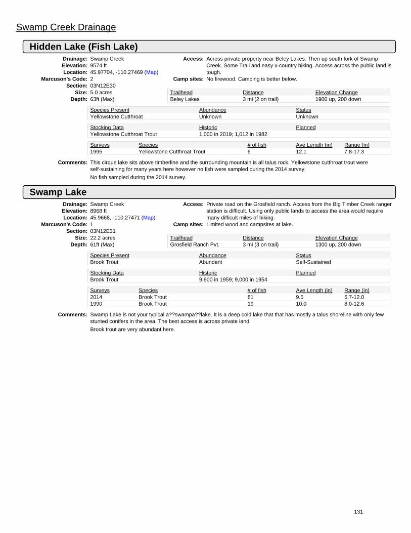
Swamp Creek Drainage
Hidden Lake (Fish Lake)Drainage: Swamp CreekElevation: 9574 ftLocation: 45.97704, -110.27469 (Map)
Marcuson's Code: 2Section: 03N12E30
Size: 5.0 acresDepth: 63ft (Max)
Access: Across private property near Beley Lakes. Then up south fork of SwampCreek. Some Trail and easy x-country hiking. Access across the public land istough.
Camp sites: No firewood. Camping is better below.
Trailhead Distance Elevation ChangeBeley Lakes 3 mi (2 on trail) 1900 up, 200 down
Species Present Abundance StatusYellowstone Cutthroat Unknown Unknown
Stocking Data Historic PlannedYellowstone Cutthroat Trout 1,000 in 2019; 1,012 in 1982
Surveys Species # of fish Ave Length (in) Range (in)1995 Yellowstone Cutthroat Trout 6 12.1 7.8-17.3
Comments: This cirque lake sits above timberline and the surrounding mountain is all talus rock. Yellowstone cutthroat trout wereself-sustaining for many years here however no fish were sampled during the 2014 survey.
No fish sampled during the 2014 survey.
Swamp LakeDrainage: Swamp CreekElevation: 8968 ftLocation: 45.9668, -110.27471 (Map)
Marcuson's Code: 1Section: 03N12E31
Size: 22.2 acresDepth: 61ft (Max)
Access: Private road on the Grosfield ranch. Access from the Big Timber Creek rangerstation is difficult. Using only public lands to access the area would requiremany difficult miles of hiking.
Camp sites: Limited wood and campsites at lake.
Trailhead Distance Elevation ChangeGrosfield Ranch Pvt. 3 mi (3 on trail) 1300 up, 200 down
Species Present Abundance StatusBrook Trout Abundant Self-Sustained
Stocking Data Historic PlannedBrook Trout 9,900 in 1959; 9,000 in 1954
Surveys Species # of fish Ave Length (in) Range (in)2014 Brook Trout 81 9.5 6.7-12.01990 Brook Trout 19 10.0 8.0-12.6
Comments: Swamp Lake is not your typical a??swampa??lake. It is a deep cold lake that that has mostly a talus shoreline with only fewstunted conifers in the area. The best access is across private land.
Brook trout are very abundant here.
131

Sweet Grass Creek Drainage
Campfire Lake (Hindu Lake)Drainage: Sweet Grass CreekElevation: 8695 ftLocation: 46.06927, -110.39913 (Map)
Marcuson's Code: 23Section: 04N11E30
Size: 35.4 acresDepth: 30ft (Max)
Access: Good trail across private ground to Trail #122 then #123. 15 miles, up 2,200ft, down 200.
Camp sites: Campsites test firewood available.
Trailhead Distance Elevation ChangeSweet Grass Creek 15 mi (15 on trail) 2200 up, 200 down
Species Present Abundance StatusYellowstone Cutthroat Common Stocked
Stocking Data Historic PlannedCutthroat Trout 45,000 in 1932Yellowstone Cutthroat Trout 5,310 in 2016; 5,310 in 2008 5,310 in 2024
Surveys Species # of fish Ave Length (in) Range (in)1999 No Fish Caught 01995 Yellowstone Cutthroat Trout 11 11.0 6.9-17.2
Comments: This pretty lake that sits just below timberline is located on a bench above Moose Lake. It receives a moderate number ofvisitors.
A poor net set may have resulted in the low number of fish sampled during the 2014 survey.
Cascade LakeDrainage: Sweet Grass CreekElevation: 8961 ftLocation: 46.06524, -110.26188 (Map)
Marcuson's Code: 16Section: 04N12E29
Size: 6.8 acresDepth: 25ft (Max)
Access: Access is difficult. From half moon campground up over the ridge takes 5.5hours. The outlet looks bad for access.
Camp sites: No firewood. The lake is surrounded by talus rock mountains.
Trailhead Distance Elevation ChangeBig Timber Creek 3.5 mi (None on trail) 3310 up, 925 down
Species Present Abundance StatusYellowstone Cutthroat Common Stock, with some natural reproduction
Stocking Data Historic PlannedBrook Trout 764 in 1946Yellowstone Cutthroat Trout 340 in 2019; 340 in 2011
Surveys Species # of fish Ave Length (in) Range (in)2014 Yellowstone Cutthroat Trout 22 14.5 12.3-17.31999 Yellowstone Cutthroat Trout 8 19.5 17.3-21.8
Comments: Cascade Lake sits well above timberline in a narrow cirque basin that receives limited sunlight and receives very little use. It isno surprise there is very little use as the access is very tough.
Cave LakeDrainage: Sweet Grass CreekElevation: 8790 ftLocation: 46.07035, -110.32177 (Map)
Marcuson's Code: 18Section: 04N11E26
Size: 15.5 acresDepth: 41ft (Max)
Access: Head up Milly Creek ~4 miles from the Maintained Trail up sweet grass creek(Trail #122). Access to #122 is across private land.
Camp sites: There are a few campsites and some firewood available.
Trailhead Distance Elevation ChangeSweet Grass Creek 8 mi (4 on trail) 2600 up, 200 down
Species Present Abundance StatusGolden Trout Common Self-SustainedGolden Trout Hybrid Common Self-Sustained
Stocking Data Historic PlannedGolden Trout 410 in 2003; 1,012 in 1992
Surveys Species # of fish Ave Length (in) Range (in)2014 Golden Trout 8 17.8 13.4-22.31999 Golden Trout 11 13.3 8.3-18.8
Comments: Cave Lake is a beautiful lake in an open basin with a few scattered trees. The shoreline is 75% talus rock with the other 25%being timber and grass.
Hybridization of this golden trout population was detected in 2003.
132

Moose LakeDrainage: Sweet Grass CreekElevation: 7951 ftLocation: 46.06709, -110.38658 (Map)
Marcuson's Code: 21Section: 04N11E29
Size: 13.1 acresDepth: 11ft (Max)
Access: Maintained trail up the Middle Fork of Sweet Grass Creek, or from PorcupineRanger Station. Good trail.
Camp sites: There are many campsites and firewood is plentiful.
Trailhead Distance Elevation ChangeSweet Grass Creek 14 mi (14 on trail) 1500 up, 200 down
Species Present Abundance StatusRainbow Trout Common Self-Sustained
Stocking Data Historic PlannedCutthroat Trout 7,040 in 1931Yellowstone Cutthroat Trout 3,492 in 1941
Surveys Species # of fish Ave Length (in) Range (in)2014 Rainbow Trout 19 10.2 7.0-13.72006 Rainbow Trout 4 10.3 6.3-14.0
Comments: This stunning lake is located in a timbered valley at the upper end of the Middle Fork of Sweet Grass Creek. There is sign ofmoderate to light use here. The lake sits on private land.
North Fork LakeDrainage: Sweet Grass CreekElevation: 8520 ftLocation: 46.1108, -110.3796 (Map)
Marcuson's Code: 25Section: 4N11E8
Size: 4.816 acresDepth:
Access: Up north fork of sweet Grass Creek Via Trail from sweet Grass Creek. Goodtrail.
Camp sites: Campsites test firewood available.
Trailhead Distance Elevation ChangeSweet Grass Creek 13 mi (13 on trail) 2100 up, 200 down
Species Present Abundance StatusYellowstone Cutthroat Common Self-Sustained
Surveys Species # of fish Ave Length (in) Range (in)2014 Yellowstone Cutthroat Trout 7 8.5 4.9-12.71990 Yellowstone Cutthroat Trout 37 9.5 6.3-14.0
Comments:
Sunlight LakeDrainage: Sweet Grass CreekElevation: 8895 ftLocation: 46.10989, -110.38896 (Map)
Marcuson's Code: 26Section: 04N11E8
Size: 8.0 acresDepth: 34ft (Max)
Access: Follow the Cattle Trail up the north fork ~3 1/2 miles from the maintained trailup sweet Grass Creek.
Camp sites: Campsites available close below the lake. Wood is scarce.
Trailhead Distance Elevation ChangeSweet Grass Creek 13.5 mi (13.5 on trail) 2500 up, 200 down
Species Present Abundance StatusYellowstone Cutthroat Common Stocked
Stocking Data Historic PlannedBrook Trout 11,000 in 1937Cutthroat Trout 25,200 in 1939Rainbow Trout 22,400 in 1941Yellowstone Cutthroat Trout 1,000 in 2018; 1,000 in 2010 1,000 in 2025
Surveys Species # of fish Ave Length (in) Range (in)2014 Yellowstone Cutthroat Trout 53 9.4 7.6-12.21990 Yellowstone Cutthroat Trout 15 11.9 7.1-15.2
Comments: The lake sits just above timberline in an open basin. The shoreline is roughly 60% rock and 40% grass. The lake was about 1/2covered with ice during the 7/23/14 survey.
Yellowstone cutthroat trout were doing well and very abundant when surveyed in 2014.
133


