ASX and MEDIA RELEASE 21 January 2015 NEW PORPHYRY GOLD-COPPER MINERALISATION IN THE KAISER PROJECT A 1,672 metre RC drilling program has been completed at the Kaiser Project in NSW to test targets peripheral to the known Kaiser gold-copper mineralisation. A new zone of porphyry style gold-copper mineralisation has been identified at the Duke Prospect: KSRC010 16m @ 0.87% Cu, 0.57g/t Au from 126 metres including 4m @ 1.45% Cu, 0.78g/t Au from 128 metres and 3m @ 1.52% Cu, 1.13g/t Au from 139 metres and 14m @ 0.63% Cu, 0.58g/t Au from 151 metres within 112m @ 0.36% Cu, 0.24g/t Au from 115 metres KSRC011 54m @ 0.33% Cu, 0.14g/t Au from 72 metres including 5m @ 1.15% Cu, 0.45g/t Au from 73 metres and 79m @ 0.37% Cu,0.22g/t Au from 134 metres including 3m @ 0.85% Cu, 0.52g/t Au from 198 metres Mineralisation and alteration within the Duke Prospect cover an area of 450 metres by 200 metres. The Kaiser Project lies within the broader Bodangora Project where similar porphyry style gold-copper mineralisation associated with the Comobella Intrusive Complex (CIC) was identified by drilling in 2012 and highlights the potential of the area to host significant mineralisation. Ground Floor, 89 Burswood Road, Burswood WA 6100, AUSTRALIA (PO Box 4384, Victoria Park WA 6979, AUSTRALIA) Telephone: +61 8 9227 5677 Facsimile: +61 8 9227 8178 www.alkane.com.au [email protected]For personal use only
Transcript
ASX and MEDIA RELEASE 21 January 2015
NEW PORPHYRY GOLD-COPPER MINERALISATION IN THE KAISER PROJECT
A 1,672 metre RC drilling program has been completed at the Kaiser Project in NSW to test targets peripheral to the known Kaiser gold-copper mineralisation. A new zone of porphyry style gold-copper mineralisation has been identified
at the Duke Prospect:
KSRC010 16m @ 0.87% Cu, 0.57g/t Au from 126 metres including 4m @ 1.45% Cu, 0.78g/t Au from 128 metres and 3m @ 1.52% Cu, 1.13g/t Au from 139 metres and 14m @ 0.63% Cu, 0.58g/t Au from 151 metres
within 112m @ 0.36% Cu, 0.24g/t Au from 115 metres
KSRC011 54m @ 0.33% Cu, 0.14g/t Au from 72 metres including 5m @ 1.15% Cu, 0.45g/t Au from 73 metres and 79m @ 0.37% Cu,0.22g/t Au from 134 metres including 3m @ 0.85% Cu, 0.52g/t Au from 198 metres
Mineralisation and alteration within the Duke Prospect cover an area of 450 metres by 200 metres.
The Kaiser Project lies within the broader Bodangora Project where similar porphyry style gold-copper mineralisation associated with the Comobella Intrusive Complex (CIC) was identified by drilling in 2012 and highlights the potential of the area to host significant mineralisation.
Ground Floor, 89 Burswood Road, Burswood WA 6100, AUSTRALIA (PO Box 4384, Victoria Park WA 6979, AUSTRALIA) Telephone: +61 8 9227 5677 Facsimile: +61 8 9227 8178
Alkane Resources Ltd – Kaiser ASX Announcement 21 January 2015
The Kaiser Project (EL6209) is located at the northern extent of the Molong Volcanic Belt and is encompassed by Alkane’s Bodangora Project (EL4022). The Molong Volcanic Belt is a well-defined geological region considered highly prospective for, and host to, several economically important examples of porphyry gold-copper mineralisation e.g. Cadia Valley alkalic porphyry deposits. Alkane has the right to earn a 100% interest in EL6209 from Ajax Joinery Pty Ltd for payment of $10,000 on transfer of the licence, payment of $200,000 following expenditure of $500,000 on exploration prior to 23 December 2015 and a 2% net smelter return on saleable products. An initial RC drilling program undertaken in early 2014 and comprising 5 holes for a total of 1,094 metres tested the previously known Kaiser and Kaiser East prospects, and identified alkalic porphyry styled mineralisation at the previously unknown McGregor prospect to the west. Ongoing assessment of existing exploration data incorporating, where possible, additional sampling of historic drill core has continued to highlight the association of existing mineralisation in the region with a hydrothermal alteration zonation typical of an alkalic porphyry gold-copper mineralised system. The recent drilling program comprising 1,672 metres in 7 holes targeted two prospect areas:
McGregor where porphyry style mineralisation was identified in early 2014 based on the initial re-interpretation of the geological model; and
Duke where structural interpretation of historical ground magnetic data and alteration vectoring identified a target area which had been poorly tested by previous explorers.
Drilling of the McGregor target was hampered by high water inflows and holes were abandoned prior to reaching target depth. At Duke, porphyry mineralisation occurs within a large zone (450m by 200m) of encouraging alkalic porphyry alteration. Mineralisation appears to occur in three zones,
Central Zone: the most significant area of new mineralisation with historic drilling by CRA Exploration intersecting the margins of the target area. This new zone is best represented in KSRC010 which intersected several higher grade zones of mineralisation including 16m @ 0.87% Cu & 0.57g/t Au (including 4m @ 1.45% Cu & 0.78 g/t Au from 128m and 3m @ 1.52% Cu & 1.13g/t Au from 139m) and 14m @ 0.63% Cu & 0.58g/t Au within a broader lower grade envelope of 112m @ 0.36% Cu & 0.24g/t Au;
Western Zone: is best represented by KSRC009 (12m @ 0.2% Cu & 0.82g/t Au from surface). This western zone is separated from the Central Zone by a north-south fault. Mineralisation is associated with magnetite bearing alteration with ground magnetic data indicating the zone remains untested to the north and is open at depth.
Eastern Zone – a sub-vertical zone of mineralisation separated from the Central Zone by an unmineralised, later diorite intrusive. Mineralisation is associated with magnetite bearing alteration and was intersected in the top of hole KSRC010 (32m @ 0.14% Cu & 0.24 g/t Au from 26m) and at depth in historic Newcrest drill hole NKD002 (86m @ 0.26% Cu & 0.43 g/t Au from 421m).
Bodangora Project As stated, the Kaiser Project lies within the Bodangora Project where similar porphyry style gold-copper mineralisation associated with the Comobella Intrusive Complex (CIC) was identified by drilling in 2012. The CIC is a 4km by 3km monzonite intrusive with associated alteration and skarn mineralisation located about 7km northwest of Kaiser. Alkane has a large tenement holding in the northern Molong Belt, a
For
per
sona
l use
onl
y
3/12
Alkane Resources Ltd – Kaiser ASX Announcement 21 January 2015
region emerging as highly prospective for alkalic porphyry gold-copper mineralisation. Multiple targets occur within the Bodangora, Kaiser and adjoining Finns Crossing projects.
KAISER PROJECT RC DRILLING – 20 January 2015 (>0.1% Cu)
KSRC011 689685 6412457 -56 185 318 12 44 32 0.07 0.14 Duke Central
and 55 65 10 0.19 0.24
and 72 126 54 0.14 0.33
incl. 73 78 5 0.45 1.15
and 134 213 79 0.22 0.37
incl. 198 201 3 0.52 0.85
and 221 230 9 0.14 0.21
KSRC012 689096 6412406 -50 90 210 NO SIGNIFICANT RESULTS McGregor
Competent Person Unless otherwise advised above, the information in this report that relates to exploration results, mineral resources and ore reserves is based on information compiled by Mr D I Chalmers, FAusIMM, FAIG, (director of the Company) who has sufficient experience which is relevant to the style of mineralisation and type of deposit under consideration and to the activity which he is undertaking to qualify as a Competent Person as defined in the 2012 Edition of the Australasian Code for Reporting of Exploration Results, Mineral Resources and Ore Reserves. Mr Chalmers consents to the inclusion in this report of the matters based on his information in the form and context in which it appears Disclaimer This report contains certain forward looking statements and forecasts, including possible or assumed reserves and resources, production levels and rates, costs, prices, future performance or potential growth of Alkane Resources Ltd, industry growth or other trend projections. Such statements are not a guarantee of future performance and involve unknown risks and uncertainties, as well as other factors which are beyond the control of Alkane Resources Ltd. Actual results and developments may differ materially from those expressed or implied by these forward looking statements depending on a variety of factors. Nothing in this report should be construed as either an offer to sell or a solicitation of an offer to buy or sell securities.
For
per
sona
l use
onl
y
4/12
Alkane Resources Ltd – Kaiser ASX Announcement 21 January 2015
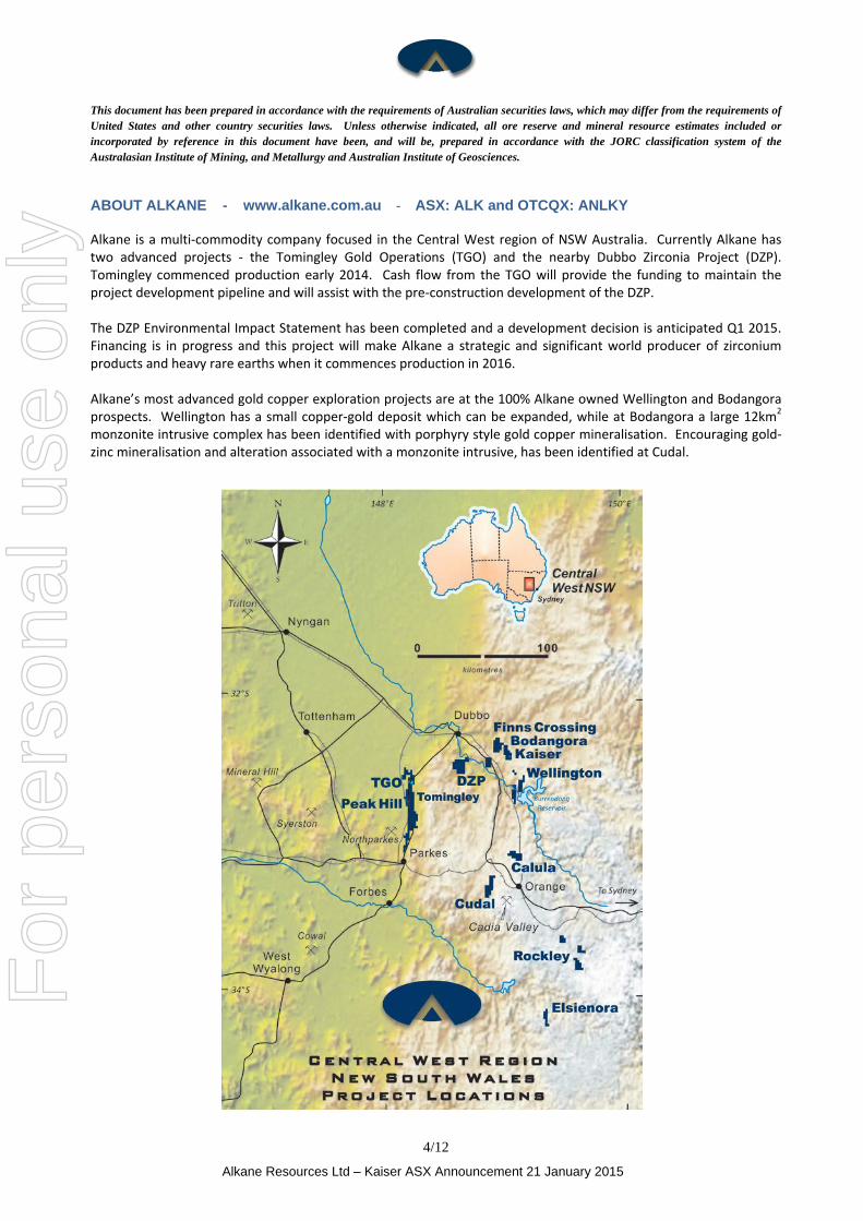
This document has been prepared in accordance with the requirements of Australian securities laws, which may differ from the requirements of United States and other country securities laws. Unless otherwise indicated, all ore reserve and mineral resource estimates included or incorporated by reference in this document have been, and will be, prepared in accordance with the JORC classification system of the Australasian Institute of Mining, and Metallurgy and Australian Institute of Geosciences. ABOUT ALKANE - www.alkane.com.au - ASX: ALK and OTCQX: ANLKY Alkane is a multi-commodity company focused in the Central West region of NSW Australia. Currently Alkane has two advanced projects - the Tomingley Gold Operations (TGO) and the nearby Dubbo Zirconia Project (DZP). Tomingley commenced production early 2014. Cash flow from the TGO will provide the funding to maintain the project development pipeline and will assist with the pre-construction development of the DZP. The DZP Environmental Impact Statement has been completed and a development decision is anticipated Q1 2015. Financing is in progress and this project will make Alkane a strategic and significant world producer of zirconium products and heavy rare earths when it commences production in 2016. Alkane’s most advanced gold copper exploration projects are at the 100% Alkane owned Wellington and Bodangora prospects. Wellington has a small copper-gold deposit which can be expanded, while at Bodangora a large 12km2 monzonite intrusive complex has been identified with porphyry style gold copper mineralisation. Encouraging gold-zinc mineralisation and alteration associated with a monzonite intrusive, has been identified at Cudal.
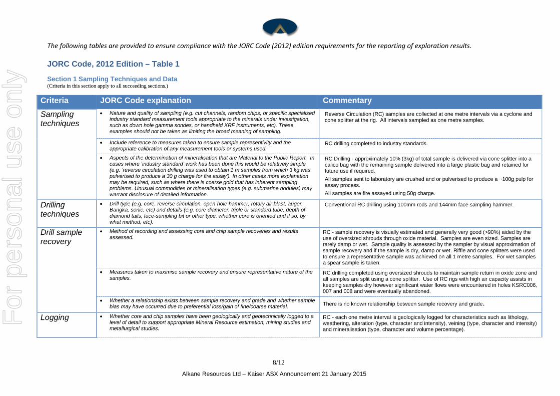
The following tables are provided to ensure compliance with the JORC Code (2012) edition requirements for the reporting of exploration results. JORC Code, 2012 Edition – Table 1
Section 1 Sampling Techniques and Data (Criteria in this section apply to all succeeding sections.)
• Nature and quality of sampling (e.g. cut channels, random chips, or specific specialised industry standard measurement tools appropriate to the minerals under investigation, such as down hole gamma sondes, or handheld XRF instruments, etc). These examples should not be taken as limiting the broad meaning of sampling.
Reverse Circulation (RC) samples are collected at one metre intervals via a cyclone and cone splitter at the rig. All intervals sampled as one metre samples.
• Include reference to measures taken to ensure sample representivity and the
appropriate calibration of any measurement tools or systems used. RC drilling completed to industry standards.
• Aspects of the determination of mineralisation that are Material to the Public Report. In cases where ‘industry standard’ work has been done this would be relatively simple (e.g. ‘reverse circulation drilling was used to obtain 1 m samples from which 3 kg was pulverised to produce a 30 g charge for fire assay’). In other cases more explanation may be required, such as where there is coarse gold that has inherent sampling problems. Unusual commodities or mineralisation types (e.g. submarine nodules) may warrant disclosure of detailed information.
RC Drilling - approximately 10% (3kg) of total sample is delivered via cone splitter into a calico bag with the remaining sample delivered into a large plastic bag and retained for future use if required. All samples sent to laboratory are crushed and or pulverised to produce a ~100g pulp for assay process. All samples are fire assayed using 50g charge.
Drilling techniques
• Drill type (e.g. core, reverse circulation, open-hole hammer, rotary air blast, auger, Bangka, sonic, etc) and details (e.g. core diameter, triple or standard tube, depth of diamond tails, face-sampling bit or other type, whether core is oriented and if so, by what method, etc).
Conventional RC drilling using 100mm rods and 144mm face sampling hammer.
Drill sample recovery
• Method of recording and assessing core and chip sample recoveries and results assessed.
RC - sample recovery is visually estimated and generally very good (>90%) aided by the use of oversized shrouds through oxide material. Samples are even sized. Samples are rarely damp or wet. Sample quality is assessed by the sampler by visual approximation of sample recovery and if the sample is dry, damp or wet. Riffle and cone splitters were used to ensure a representative sample was achieved on all 1 metre samples. For wet samples a spear sample is taken.
• Measures taken to maximise sample recovery and ensure representative nature of the samples.
RC drilling completed using oversized shrouds to maintain sample return in oxide zone and all samples are split using a cone splitter. Use of RC rigs with high air capacity assists in keeping samples dry however significant water flows were encountered in holes KSRC006, 007 and 008 and were eventually abandoned.
• Whether a relationship exists between sample recovery and grade and whether sample bias may have occurred due to preferential loss/gain of fine/coarse material. There is no known relationship between sample recovery and grade.
Logging • Whether core and chip samples have been geologically and geotechnically logged to a level of detail to support appropriate Mineral Resource estimation, mining studies and metallurgical studies.
RC - each one metre interval is geologically logged for characteristics such as lithology, weathering, alteration (type, character and intensity), veining (type, character and intensity) and mineralisation (type, character and volume percentage).
8/12
Alkane Resources Ltd – Kaiser ASX Announcement 21 January 2015
For
per
sona
l use
onl
y
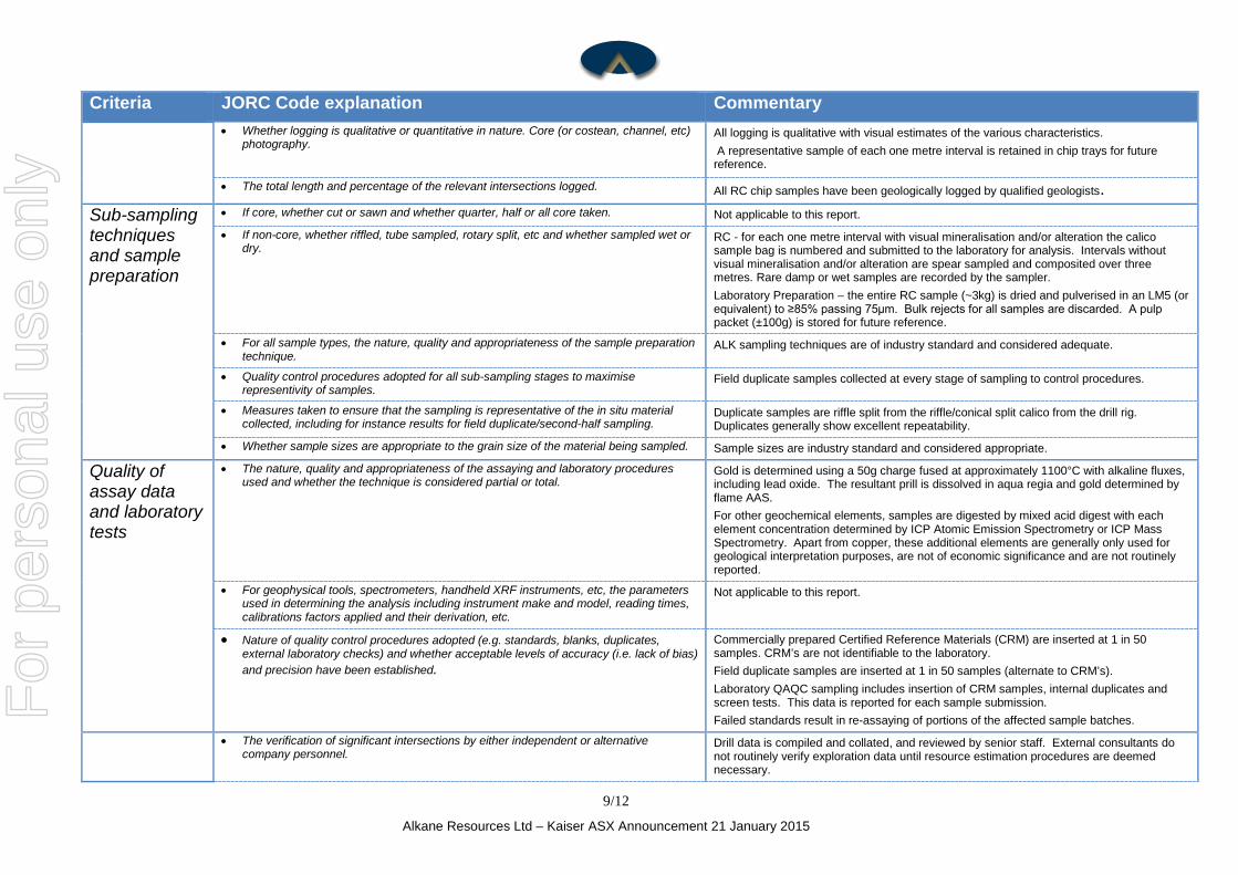
Criteria JORC Code explanation Commentary • Whether logging is qualitative or quantitative in nature. Core (or costean, channel, etc)
photography. All logging is qualitative with visual estimates of the various characteristics. A representative sample of each one metre interval is retained in chip trays for future reference.
• The total length and percentage of the relevant intersections logged. All RC chip samples have been geologically logged by qualified geologists. Sub-sampling techniques and sample preparation
• If core, whether cut or sawn and whether quarter, half or all core taken. Not applicable to this report.
• If non-core, whether riffled, tube sampled, rotary split, etc and whether sampled wet or dry.
RC - for each one metre interval with visual mineralisation and/or alteration the calico sample bag is numbered and submitted to the laboratory for analysis. Intervals without visual mineralisation and/or alteration are spear sampled and composited over three metres. Rare damp or wet samples are recorded by the sampler. Laboratory Preparation – the entire RC sample (~3kg) is dried and pulverised in an LM5 (or equivalent) to ≥85% passing 75µm. Bulk rejects for all samples are discarded. A pulp packet (±100g) is stored for future reference.
• For all sample types, the nature, quality and appropriateness of the sample preparation technique.
ALK sampling techniques are of industry standard and considered adequate.
• Quality control procedures adopted for all sub-sampling stages to maximise representivity of samples.
Field duplicate samples collected at every stage of sampling to control procedures.
• Measures taken to ensure that the sampling is representative of the in situ material collected, including for instance results for field duplicate/second-half sampling.
Duplicate samples are riffle split from the riffle/conical split calico from the drill rig. Duplicates generally show excellent repeatability.
• Whether sample sizes are appropriate to the grain size of the material being sampled. Sample sizes are industry standard and considered appropriate.
Quality of assay data and laboratory tests
• The nature, quality and appropriateness of the assaying and laboratory procedures used and whether the technique is considered partial or total.
Gold is determined using a 50g charge fused at approximately 1100°C with alkaline fluxes, including lead oxide. The resultant prill is dissolved in aqua regia and gold determined by flame AAS. For other geochemical elements, samples are digested by mixed acid digest with each element concentration determined by ICP Atomic Emission Spectrometry or ICP Mass Spectrometry. Apart from copper, these additional elements are generally only used for geological interpretation purposes, are not of economic significance and are not routinely reported.
• For geophysical tools, spectrometers, handheld XRF instruments, etc, the parameters used in determining the analysis including instrument make and model, reading times, calibrations factors applied and their derivation, etc.
Not applicable to this report.
• Nature of quality control procedures adopted (e.g. standards, blanks, duplicates, external laboratory checks) and whether acceptable levels of accuracy (i.e. lack of bias) and precision have been established.
Commercially prepared Certified Reference Materials (CRM) are inserted at 1 in 50 samples. CRM’s are not identifiable to the laboratory. Field duplicate samples are inserted at 1 in 50 samples (alternate to CRM’s). Laboratory QAQC sampling includes insertion of CRM samples, internal duplicates and screen tests. This data is reported for each sample submission. Failed standards result in re-assaying of portions of the affected sample batches.
• The verification of significant intersections by either independent or alternative company personnel.
Drill data is compiled and collated, and reviewed by senior staff. External consultants do not routinely verify exploration data until resource estimation procedures are deemed necessary.
9/12
Alkane Resources Ltd – Kaiser ASX Announcement 21 January 2015
For
per
sona
l use
onl
y
Criteria JORC Code explanation Commentary Verification of sampling and assaying
• The use of twinned holes. No twinned holes have been drilled at this early stage of exploration.
• Documentation of primary data, data entry procedures, data verification, data storage (physical and electronic) protocols.
All drill hole logging and sampling data is entered directly into field data entry spreadsheets for transfer and storage in an access database with verification protocols in place. All primary assay data is received from the laboratory as electronic data files which are imported into sampling database with verification procedures in place. QAQC analysis is undertaken for each laboratory report. Digital copies of Certificates of Analysis (COA) are stored in a central database with regular (daily) backup. Original survey data is stored on site. Data is also verified on import into various software packages.
• Discuss any adjustment to assay data. No assay data was adjusted. Location of data points
• Accuracy and quality of surveys used to locate drill holes (collar and down-hole surveys), trenches, mine workings and other locations used in Mineral Resource estimation.
Drill holes are laid out using hand held GPS (accuracy ± 2m) then DGPS surveyed accurately (± 0.1m) by licenced surveyors on completion. Down hole orientation surveys were completed at a nominal 30m down hole interval using a Reflex Instruments: EZ-Trac multishot survey instrument.
• Specification of the grid system used. MGA (Zone 55), GDA94
• Quality and adequacy of topographic control. As noted above, all drill holes DGPS surveyed accurately (± 0.1m) by licenced surveyors on completion.
Data spacing and distribution
• Data spacing for reporting of Exploration Results. At this early exploration stage, the data spacing is variable as the focus is on identifying new zones of mineralisation.
• Whether the data spacing and distribution is sufficient to establish the degree of geological and grade continuity appropriate for the Mineral Resource and Ore Reserve estimation procedure(s) and classifications applied.
Not applicable.
• Whether sample compositing has been applied. Not applicable.
Orientation of data in relation to geological structure
• Whether the orientation of sampling achieves unbiased sampling of possible structures and the extent to which this is known, considering the deposit type.
Much care is given to attempt to intersect structure at an optimal angle.
• If the relationship between the drilling orientation and the orientation of key mineralised structures is considered to have introduced a sampling bias, this should be assessed and reported if material.
It is not thought that drilling direction will bias assay data significantly.
Sample security
• The measures taken to ensure sample security. All samples are bagged in tied in numbered calico bags, grouped into larger tied polyweave bags and transported 1 hour to Orange, to ALS in Orange. All sample submissions are documented via ALS tracking system and all assays are reported via email. Sample pulps are returned to site and stored for an appropriate length of time (minimum 3 years). The Company has in place protocols to ensure data security.
Audits or reviews
• The results of any audits or reviews of sampling techniques and data. The Company does not routinely have external consultants verify exploration data until resource estimation procedures are deemed necessary.
10/12
Alkane Resources Ltd – Kaiser ASX Announcement 21 January 2015
For
per
sona
l use
onl
y
Section 2 Reporting of Exploration Results (Criteria listed in the preceding section also apply to this section.)
Criteria JORC Code explanation Commentary Mineral tenement and land tenure status
• Type, reference name/number, location and ownership including agreements or material issues with third parties such as joint ventures, partnerships, overriding royalties, native title interests, historical sites, wilderness or national park and environmental settings.
Alkane can acquire a 100% interest in EL6209 for payment of $10,000 on transfer of the licence (already paid), and payment of $200,000 and a 2% net smelter return on saleable products following expenditure of $500,000 on exploration within two years from December 2013.
• The security of the tenure held at the time of reporting along with any known impediments to obtaining a licence to operate in the area.
Expiry date of the licence is 11 March 2017.
Exploration done by other parties
• Acknowledgment and appraisal of exploration by other parties. Significant historical drilling activity has been conducted within the bounds of EL6209. We have records of 14 AC (170m), 78 RC (7591m) and 45 DD holes (7833m) = 15,594m. ~48% of this drilling activity was focussed at the Kaiser, Kaiser East and Kaiser Extended Prospect areas, where there have been a total of 32 DD (4558m), 39 RC drill holes (2939m) for a total of 7497m. The remainder of drilling activity was focussed on the Kaiser Intrusive Complex (KIC). As outlined previously it is the margin of the KIC which is considered prospective and is where the McGregor discovery is located. As shown on the attached map, the Kaiser Prospect is marked by an approximately 95m x 45m anomalous zone at surface, which has been extensively drill- tested to a depth of ~70m. The Kaiser Prospect mineralisation requires further drill testing to define its depth extents and geometry.
Geology • Deposit type, geological setting and style of mineralisation. The area is located at the northern extent of the Molong Volcanic Belt, a well-defined geological region considered highly prospective for and host to several economically important examples of porphyry Au-Cu mineralisation e.g. Cadia Valley alkalic porphyry cluster. In particular, the Ridgeway Deposit mineralisation at Cadia, which is localised along the margin of the Cadia Intrusive Complex shows similarities with the metal tenor and geological setting of the Kaiser-McGregors mineralisation, located at the margin of the Kaiser Intrusive Complex.
Drill hole Information
• A summary of all information material to the understanding of the exploration results including a tabulation of the following information for all Material drill holes: o easting and northing of the drill hole collar o elevation or RL (Reduced Level – elevation above sea level in metres) of the drill
hole collar o dip and azimuth of the hole o down hole length and interception depth o hole length.
See body of announcement and figures
• If the exclusion of this information is justified on the basis that the information is not Material and this exclusion does not detract from the understanding of the report, the Competent Person should clearly explain why this is the case.
All drill holes have been reported in this announcement.
11/12
Alkane Resources Ltd – Kaiser ASX Announcement 21 January 2015
For
per
sona
l use
onl
y
Criteria JORC Code explanation Commentary Data aggregation methods
• In reporting Exploration Results, weighting averaging techniques, maximum and/or minimum grade truncations (e.g. cutting of high grades) and cut-off grades are usually Material and should be stated.
Exploration results reported – for uncut gold grades; grades are calculated by length weighted average.
• Where aggregate intercepts incorporate short lengths of high grade results and longer lengths of low grade results, the procedure used for such aggregation should be stated and some typical examples of such aggregations should be shown in detail.
Gold and copper intercepts are calculated using a lower cut of 0.1g/t and 0.1% respectively. No top cut has been used. Internal waste (i.e. < cut off) is limited to single samples between mineralised samples that exceed either the Au of Cu cut-off grade. Short intervals of high grades that have a material impact on overall intersection are highlighted separately (see attached).
• The assumptions used for any reporting of metal equivalent values should be clearly stated.
No metal equivalents are reported.
Relationship between mineralisation widths and intercept lengths
• These relationships are particularly important in the reporting of Exploration Results -
If the geometry of the mineralisation with respect to the drill hole angle is known, its nature should be reported.
If it is not known and only the down hole lengths are reported, there should be a clear statement to this effect (e.g. ‘down hole length, true width not known’).
Significant efforts have been placed on the understanding, interpretation and, where possible, re-logging of historical diamond drilling in the tenement. This interpretation is constantly changing as new data is gathered and currently shows variable but generally steeply dipping orientation to stratigraphy. Therefore, at this early exploration stage the drilling directions chosen are deemed appropriate.
Diagrams • Appropriate maps and sections (with scales) and tabulations of intercepts should be included for any significant discovery being reported These should include, but not be limited to a plan view of drill hole collar locations and appropriate sectional views.
Cross sections and a plan showing geology with drill collars are attached.
Balanced reporting
• Where comprehensive reporting of all Exploration Results is not practicable, representative reporting of both low and high grades and/or widths should be practiced to avoid misleading reporting of Exploration Results.
Comprehensive reporting has been undertaken with all holes listed in the attached table.
Other substantive exploration data
• Other exploration data, if meaningful and material, should be reported including (but not limited to): geological observations; geophysical survey results; geochemical survey results; bulk samples – size and method of treatment; metallurgical test results; bulk density, groundwater, geotechnical and rock characteristics; potential deleterious or contaminating substances.
Not applicable.
Further work • The nature and scale of planned further work (e.g. tests for lateral extensions or depth extensions or large-scale step-out drilling).
It is recommended that further drilling be undertaken within the licence.
• Diagrams clearly highlighting the areas of possible extensions, including the main geological interpretations and future drilling areas, provided this information is not commercially sensitive.
See Figures 1, 2 and 3 attached.
12/12
Alkane Resources Ltd – Kaiser ASX Announcement 21 January 2015