COUNTRY REPORT INDONESIA 21 ST INTERNATIONAL CARTOGRAPHIC CONFERENCE (ICC) 12 TH GENERAL ASSEMBLY INTERNATIONAL CARTOGRAPHIC ASSOCIATION 10-16 AUGUST 2003 DURBAN, SOUTH AFRICA PREPARED BY THE NATIONAL COORDINATION AGENCY FOR SUR EYS AND MAPPING V BAKOSURTANAL - INDONESIA
Transcript
COUNTRY REPORT INDONESIA
21ST INTERNATIONAL CARTOGRAPHIC CONFERENCE (ICC)
12TH GENERAL ASSEMBLY
INTERNATIONAL CARTOGRAPHIC ASSOCIATION
10-16 AUGUST 2003
DURBAN, SOUTH AFRICA
PREPARED BY THE NATIONAL COORDINATION AGENCY FOR SUR EYS AND MAPPING V
BAKOSURTANAL - INDONESIA
NATIONAL COUNTRY REPORT : INDONESIA i 21ST ICC AND 12ND ICA, 10-16 AUGUST 2003, DURBAN SOUTH AFRICA
TABLE OF CONTENT
I INTRODUCTION
II MAPPING ACTIVITIES
a. TOPOGRAPHIC MAPPING
b. MARINE, COASTAL MAPPING AND AERONAUTICAL CHARTING
c. THEMATIC MAPPING
d. INTERNATIONAL BOUNDARY MAPPING
e. NATIONAL AND REGIONAL ATLAS
III DEVELOPMENT OF INDONESIAN NATIONAL SPATIAL DATA INFRASTRUCTURE (ISDI)
IV EDUCATION AND TRAINING
V ASSOCIATION
VI MAPPING AWARENESS
VII CONTRIBUTING AUTHORS
VIII CONTACT PERSON
NATIONAL COUNTRY REPORT : INDONESIA 1 21ST ICC AND 12ND ICA, 10-16 AUGUST 2003, DURBAN SOUTH AFRICA
COUNTRY REPORT
I. INTRODUCTION This Country report for the 12th General Assembly of the International Cartographic Association (ICA) at Durban, South Africa, prepared by The National Coordinating Agency for Surveys and Mapping. The progress in the field of survey, mapping, charting, education and training, association, and mapping awareness is discussed in this country report. New Policies and Direction In the beginning of the 3 rd millennium, the word economy becomes more interrelated and geared toward a free and transparent world economy. Countries in the Asia and Pacific region agree to join an Asia-Pacific Economy (APEC) to be implemented in 2020. Within South-East Asian Nation have agreed to speed up the of implementation ASEAN Free Trade Areas (AFTA). The changes that happening around the word and more specific in the Asia-Pacific and South-East Asia region and the move of Indonesia as a democratic country drives the changing of Indonesia from centralized government to autonomy. The Government Policy of Indonesia has tremendous changed as written on the Law No. 22/1999 regarding the Authority of Central and Local Government which is also give an influence to surveys and mapping activities. As a consequence, the policy on surveys and mapping must be reorganized as follow :
1. The responsibility of the Central Government and Local Government intended for preparing spatial data should be clear
2. Improving networking to the stake holder 3. Assemble a partner between central and local government and
private company as well. 4. Finished up topographic map of Indonesia 5. The establishment of a dependable National Spatial Data
Infrastructure to support the planning and implementation of the national and regional development.
6. Data spatial standardization
In anticipating this changes, as well as to make use of the availability of new technology, the National Coordinating Agency for Surveys and Mapping (BAKOSURTANAL) through a series of national meetings and consultations with its stakeholders have set up a new strategy to facilitate greater data use and data sharing through providing more access to government data for all level of government and community. The National Coordination Meeting for Surveys and Mapping (Rakornas Surta) held in July 2000 at Jakarta recommends a new vision should be set up for the National Surveys and Mapping toward. The establishment of a dependable National Spatial Data Infrastructure to support the planning and implementation of the national and regional development.
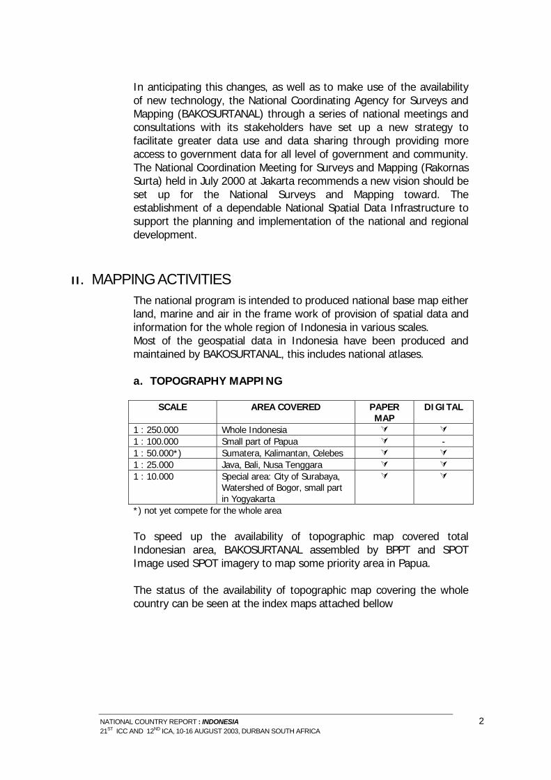
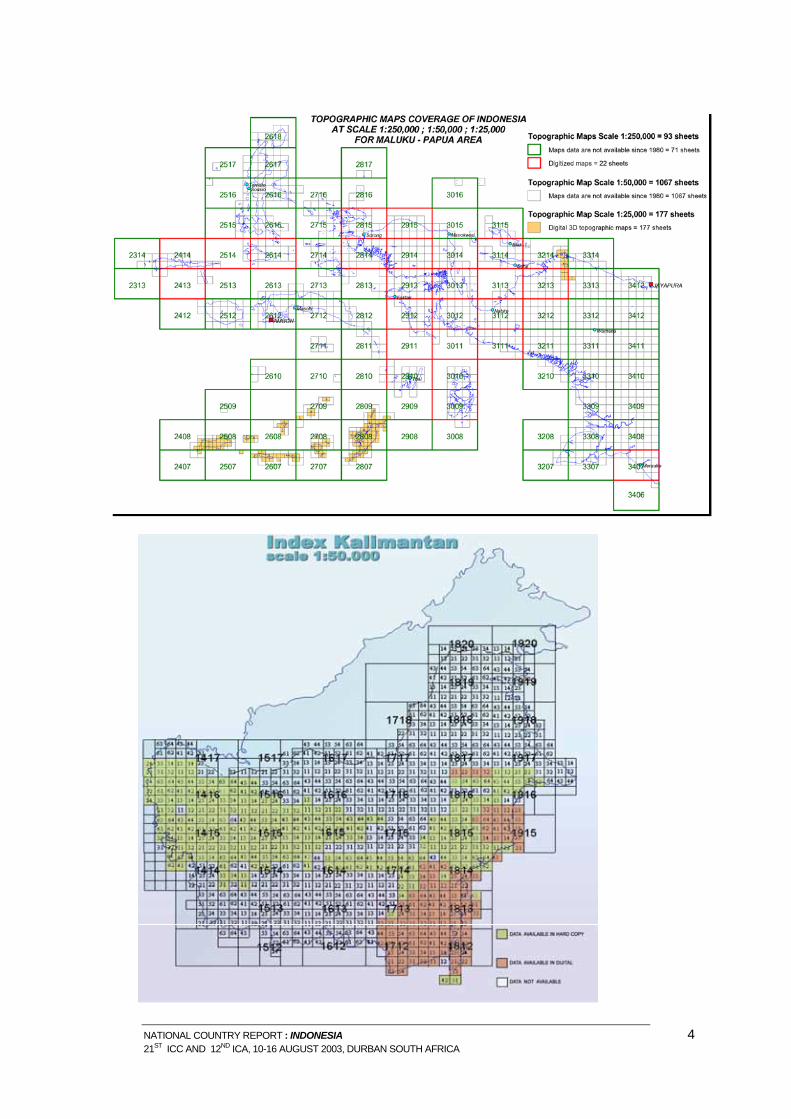
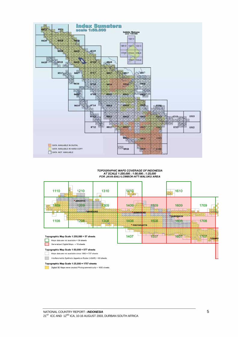
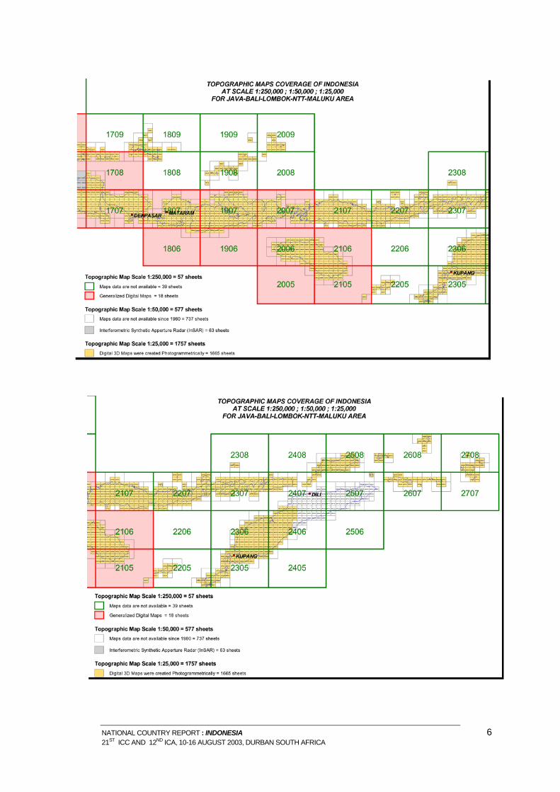
II. MAPPING ACTIVITIES The national program is intended to produced national base map either land, marine and air in the frame work of provision of spatial data and information for the whole region of Indonesia in various scales. Most of the geospatial data in Indonesia have been produced and maintained by BAKOSURTANAL, this includes national atlases. a. TOPOGRAPHY MAPPING
SCALE AREA COVERED PAPER MAP
DIGITAL
1 : 250.000 Whole Indonesia 1 : 100.000 Small part of Papua - 1 : 50.000*) Sumatera, Kalimantan, Celebes 1 : 25.000 Java, Bali, Nusa Tenggara 1 : 10.000 Special area: City of Surabaya,
Watershed of Bogor, small part in Yogyakarta
*) not yet compete for the whole area To speed up the availability of topographic map covered total Indonesian area, BAKOSURTANAL assembled by BPPT and SPOT Image used SPOT imagery to map some priority area in Papua. The status of the availability of topographic map covering the whole country can be seen at the index maps attached bellow
NATIONAL COUNTRY REPORT : INDONESIA 2 21ST ICC AND 12ND ICA, 10-16 AUGUST 2003, DURBAN SOUTH AFRICA
NATIONAL COUNTRY REPORT : INDONESIA 3 21ST ICC AND 12ND ICA, 10-16 AUGUST 2003, DURBAN SOUTH AFRICA
NATIONAL COUNTRY REPORT : INDONESIA 4 21ST ICC AND 12ND ICA, 10-16 AUGUST 2003, DURBAN SOUTH AFRICA
NATIONAL COUNTRY REPORT : INDONESIA 5 21ST ICC AND 12ND ICA, 10-16 AUGUST 2003, DURBAN SOUTH AFRICA
NATIONAL COUNTRY REPORT : INDONESIA 6 21ST ICC AND 12ND ICA, 10-16 AUGUST 2003, DURBAN SOUTH AFRICA
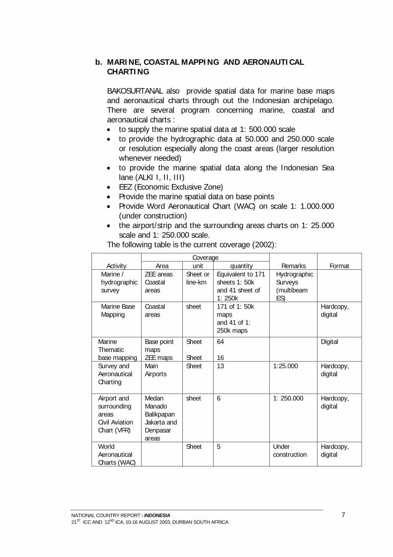
b. MARINE, COASTAL MAPPING AND AERONAUTICAL
CHARTING
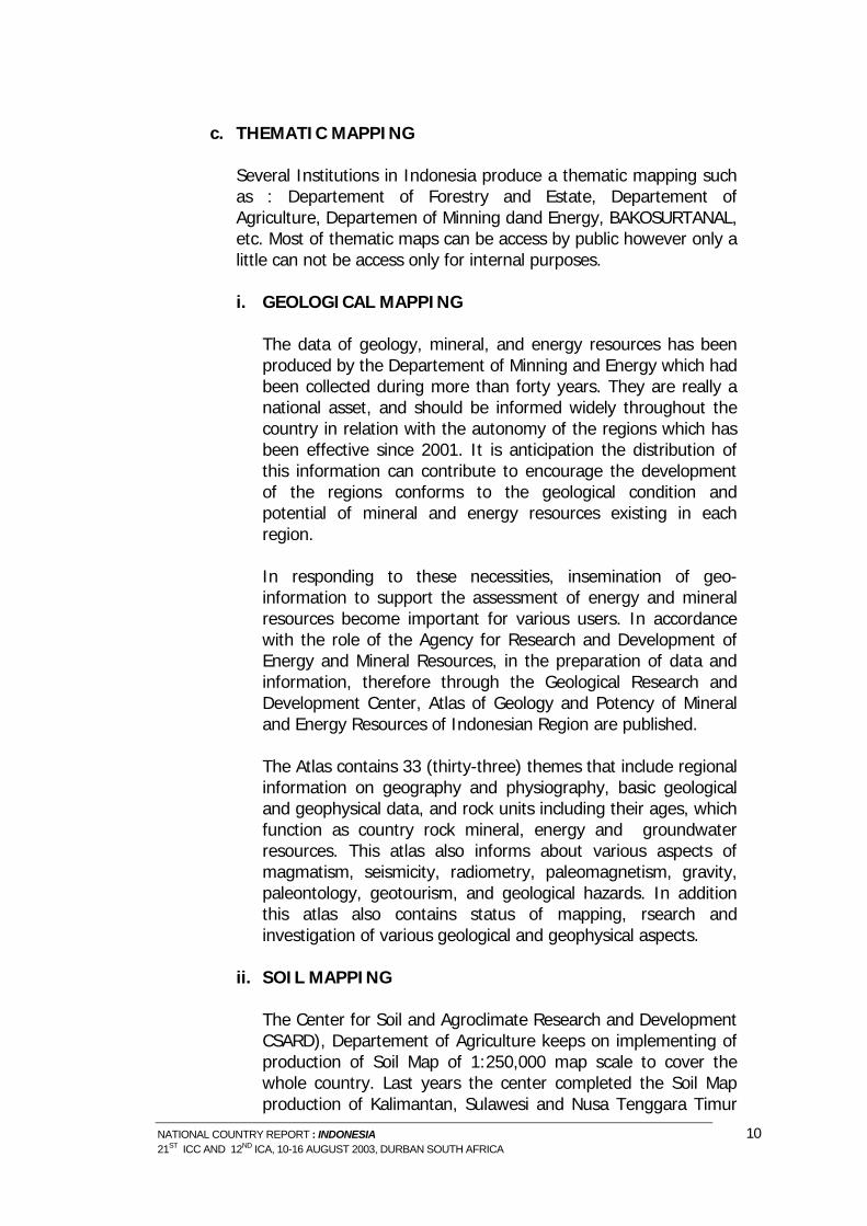
BAKOSURTANAL also provide spatial data for marine base maps and aeronautical charts through out the Indonesian archipelago. There are several program concerning marine, coastal and aeronautical charts : • to supply the marine spatial data at 1: 500.000 scale • to provide the hydrographic data at 50.000 and 250.000 scale
or resolution especially along the coast areas (larger resolution whenever needed)
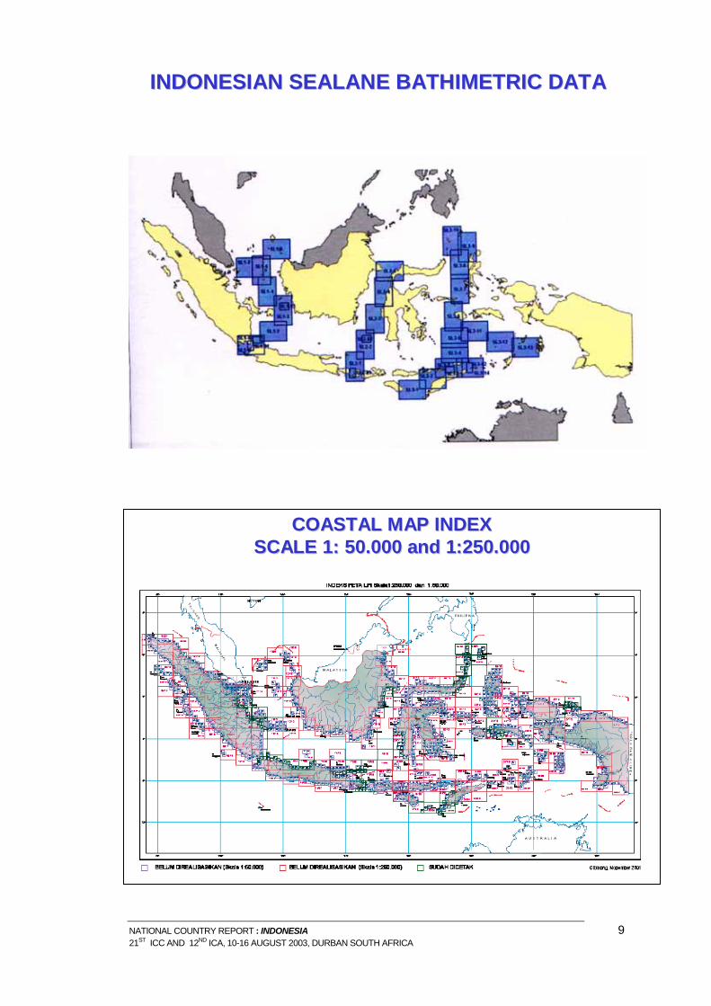
• to provide the marine spatial data along the Indonesian Sea lane (ALKI I, II, III)
• EEZ (Economic Exclusive Zone) • Provide the marine spatial data on base points • Provide Word Aeronautical Chart (WAC) on scale 1: 1.000.000
(under construction) • the airport/strip and the surrounding areas charts on 1: 25.000
scale and 1: 250.000 scale. The following table is the current coverage (2002):
Coverage Activity Area unit quantity Remarks Format
Marine / hydrographic survey
ZEE areas Coastal areas
Sheet or line-km
Equivalent to 171 sheets 1: 50k and 41 sheet of 1: 250k
Hydrographic Surveys (multibeam ES)
Marine Base Mapping
Coastal areas
sheet
171 of 1: 50k maps and 41 of 1: 250k maps
Hardcopy, digital
Marine Thematic base mapping
Base point maps ZEE maps
Sheet Sheet
64 16
Digital
Survey and Aeronautical Charting
Main Airports
Sheet 13 1:25.000 Hardcopy, digital
Airport and surrounding areas Civil Aviation Chart (VFR)
Medan Manado Balikpapan Jakarta and Denpasar areas
sheet 6 1: 250.000 Hardcopy, digital
World Aeronautical Charts (WAC)
Sheet 5 Under construction
Hardcopy, digital
NATIONAL COUNTRY REPORT : INDONESIA 7 21ST ICC AND 12ND ICA, 10-16 AUGUST 2003, DURBAN SOUTH AFRICA
NATIONAL COUNTRY REPORT : INDONESIA 9 21ST ICC AND 12ND ICA, 10-16 AUGUST 2003, DURBAN SOUTH AFRICA
c. THEMATIC MAPPING
Several Institutions in Indonesia produce a thematic mapping such as : Departement of Forestry and Estate, Departement of Agriculture, Departemen of Minning dand Energy, BAKOSURTANAL, etc. Most of thematic maps can be access by public however only a little can not be access only for internal purposes.
i. GEOLOGICAL MAPPING
The data of geology, mineral, and energy resources has been produced by the Departement of Minning and Energy which had been collected during more than forty years. They are really a national asset, and should be informed widely throughout the country in relation with the autonomy of the regions which has been effective since 2001. It is anticipation the distribution of this information can contribute to encourage the development of the regions conforms to the geological condition and potential of mineral and energy resources existing in each region. In responding to these necessities, insemination of geo-information to support the assessment of energy and mineral resources become important for various users. In accordance with the role of the Agency for Research and Development of Energy and Mineral Resources, in the preparation of data and information, therefore through the Geological Research and Development Center, Atlas of Geology and Potency of Mineral and Energy Resources of Indonesian Region are published. The Atlas contains 33 (thirty-three) themes that include regional information on geography and physiography, basic geological and geophysical data, and rock units including their ages, which function as country rock mineral, energy and groundwater resources. This atlas also informs about various aspects of magmatism, seismicity, radiometry, paleomagnetism, gravity, paleontology, geotourism, and geological hazards. In addition this atlas also contains status of mapping, rsearch and investigation of various geological and geophysical aspects.
ii. SOIL MAPPING
The Center for Soil and Agroclimate Research and Development CSARD), Departement of Agriculture keeps on implementing of production of Soil Map of 1:250,000 map scale to cover the whole country. Last years the center completed the Soil Map production of Kalimantan, Sulawesi and Nusa Tenggara Timur
NATIONAL COUNTRY REPORT : INDONESIA 10 21ST ICC AND 12ND ICA, 10-16 AUGUST 2003, DURBAN SOUTH AFRICA
areas. In total, 55 % of Soil Map of Indonesia at 1:250,000 map scale has been completed. GIS and Remote Sensing Technology are applied for :
a. Standard Rice Field Soil Mapping based on irrigation type for Java, Bali, Sumatera islands.
b. Rice field soil mapping vulnerable to drought and flood for Java
c. Research on early warning system for rice field drought in production center
d. Research on Potential Erosion Mapping Method for vegetables garden soil in highland areas.
iii. LAND RESOURCES MAPPING
The land natural resources and environmental survey and mapping program aims at inventory of land natural resources, compilation of land natural resources accounting balance, and implementing land assessment, including compilation of the land natural resources thematic database, and providing the national standards in the form of norms, guidance, procedures, standards and technical specifications for surveys and mapping of the land natural resources. The products that available as 2003 are as listed below:
No Product File Type Format Year of
Production National Scale
1 Geomorphological Map 1: 2.500.000
digital Arc/info 2000
2 Wetland Map 1: 2.500.000 digital Arc/info 2000 3 Degradation Land Map 1:
2.500.000 digital Arc/info 2000
4 Conservation Zone Map 1: 2.500.000
digital Arc/info 2000
5 Protected Zone Map 1: 2.500.000 digital Arc/info 2000 6 Catchment Area Map 1:
2.500.000 digital Arc/info 2000
7 Land Cover Map 1:1.000.000 digital Arc/info 2001,2002 8 Forest Resources Accounting
Balance 1:1.000K digital Arc/info 2002
National Scale 9 Water Resources Accounting
Balance 1: 1.000.000 digital Arc/info 2000
10 Land Resources Accounting Balance 1:1.000.000
digital Arc/info 2000
11 Mineral Resources Accounting Balance 1:1.000.000
digital Arc/info 2000
Regional Scale
NATIONAL COUNTRY REPORT : INDONESIA 11 21ST ICC AND 12ND ICA, 10-16 AUGUST 2003, DURBAN SOUTH AFRICA
NATIONAL COUNTRY REPORT : INDONESIA 12 21ST ICC AND 12ND ICA, 10-16 AUGUST 2003, DURBAN SOUTH AFRICA
12 Land Cover Map(Sulawesi,
Kalimantan) 1: 250.000
digital Arc/info 2000
13 Land System Map with attribut (Papua) 1: 250.000
digital Arc/info 2000
District/municipality Scale 12 Landform Map (Province of Lam-
pung, South Kalimantan, South Sulawesi, Bali, District of Sambas)
digital Arc/info, shp 2000
13 Conservation Zone Map (Province of Lampung, South Kalimantan, South Sulawesi, Bali)
digital Arc/info, shp 2000
NATIONAL COUNTRY REPORT : INDONESIA 13
NATURAL RESOURCES MAP INDEX SCALE 1 : 250,000
21ST ICC AND 12ND ICA, 10-16 AUGUST 2003, DURBAN SOUTH AFRICA
d. INTERNATIONAL BOUNDARY MAPPING
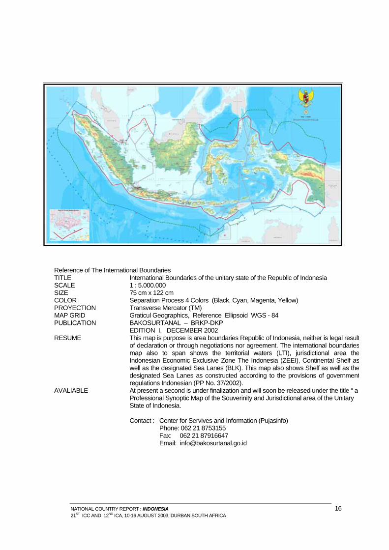
(1) Production New Map Of Indonesian International
Boundary
The National Coordination Agency for Surveys and Mapping BAKOSURTANAL - (Badan Koordinasi Survei dan Pemetaan Nasional) in cooperation with the Ministry of Ocean and Fisheries, on May 2 nd 2003, launch a new 1:5.00.000 map, depicting the International Boundaries of the unitary state of the Republic of Indonesia. Other than showing the Indonesian International Boundaries agreed with neighboring countries as well as claimed unilaterally, this beautiful map also shows the territorial waters, jurisdictional area, the Indonesian Economic Exclusive Zone The Indonesia Continental Shelf as well as the designated Sea Lanes as constructed according to the provisions of the United Nations Conventions of the Law of the Sea (UNCLOS) 1982 as well as existing International Border Agreement between Indonesia and Neighboring countries.
Production New Map of Indonesian International Boundaries The National Coordination Agency for Surveys and Mapping, a.k.a. BAKOSURTANAL (Badan Koordinasi Survei dan Pemetaan Nasional) in cooperation with the Ministry of Ocean and Fisheries, on May 2 nd 2003, launch a new 1:5000.000 map, depecting the International Boundaries of the unitary state of the Republic of Indonesia.
NATIONAL COUNTRY REPORT : INDONESIA 15 21ST ICC AND 12ND ICA, 10-16 AUGUST 2003, DURBAN SOUTH AFRICA
Reference of The International Boundaries TITLE International Boundaries of the unitary state of the Republic of Indonesia SCALE 1 : 5.000.000 SIZE 75 cm x 122 cm COLOR Separation Process 4 Colors (Black, Cyan, Magenta, Yellow) PROYECTION Transverse Mercator (TM) MAP GRID Graticul Geographics, Reference Ellipsoid WGS - 84 PUBLICATION BAKOSURTANAL – BRKP-DKP
EDITION I, DECEMBER 2002 RESUME This map is purpose is area boundaries Republic of Indonesia, neither is legal result
of declaration or through negotiations nor agreement. The international boundariesmap also to span shows the territorial waters (LTI), jurisdictional area theIndonesian Economic Exclusive Zone The Indonesia (ZEEI), Continental Shelf aswell as the designated Sea Lanes (BLK). This map also shows Shelf as well as thedesignated Sea Lanes as constructed according to the provisions of governmentregulations Indonesian (PP No. 37/2002).
AVALIABLE At present a second is under finalization and will soon be released under the title “ a Professional Synoptic Map of the Souverinity and Jurisdictional area of the Unitary State of Indonesia. Contact : Center for Servives and Information (Pujasinfo) Phone: 062 21 8753155 Fax: 062 21 87916647 Email: [email protected]
NATIONAL COUNTRY REPORT : INDONESIA 16 21ST ICC AND 12ND ICA, 10-16 AUGUST 2003, DURBAN SOUTH AFRICA
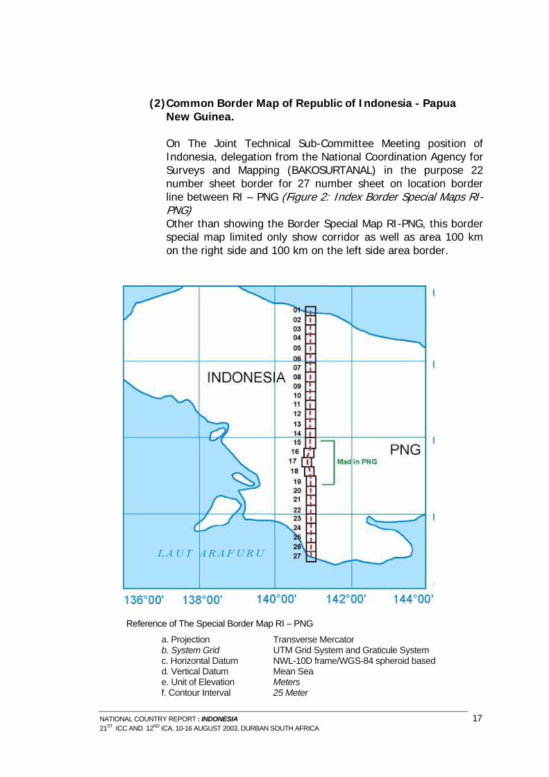
(2) Common Border Map of Republic of Indonesia - Papua
New Guinea. On The Joint Technical Sub-Committee Meeting position of Indonesia, delegation from the National Coordination Agency for Surveys and Mapping (BAKOSURTANAL) in the purpose 22 number sheet border for 27 number sheet on location border line between RI – PNG (Figure 2: Index Border Special Maps RI-PNG) Other than showing the Border Special Map RI-PNG, this border special map limited only show corridor as well as area 100 km on the right side and 100 km on the left side area border.
Border Special Maps RI-PNG
R
eference of The Special Border Map RI – PNG
a. Projection Transverse Mercator b. System Grid UTM Grid System and Graticule System c. Horizontal Datum NWL-10D frame/WGS-84 spheroid based d. Vertical Datum Mean Sea e. Unit of Elevation Meters f. Contour Interval 25 Meter
NATIONAL COUNTRY REPORT : INDONESIA 17 21ST ICC AND 12ND ICA, 10-16 AUGUST 2003, DURBAN SOUTH AFRICA
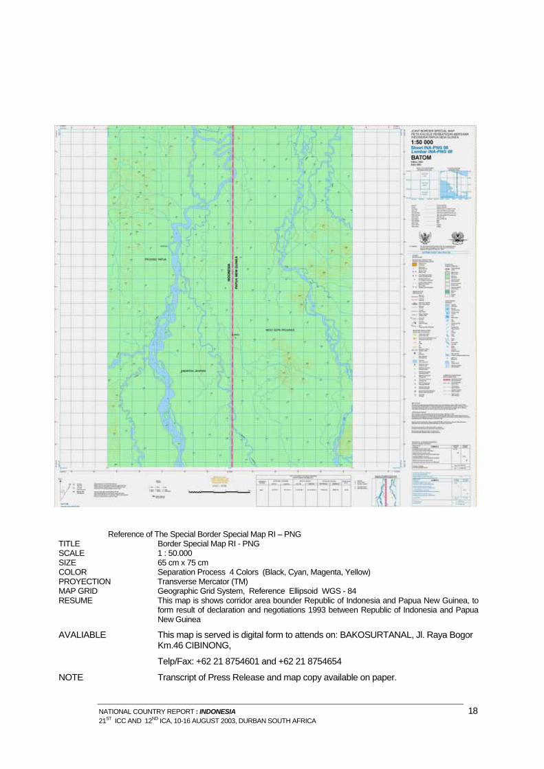
Reference of The Special Border Special Map RI – PNG TITLE Border Special Map RI - PNG SCALE 1 : 50.000 SIZE 65 cm x 75 cm COLOR Separation Process 4 Colors (Black, Cyan, Magenta, Yellow) PROYECTION Transverse Mercator (TM) MAP GRID Geographic Grid System, Reference Ellipsoid WGS - 84 RESUME This map is shows corridor area bounder Republic of Indonesia and Papua New Guinea, to
form result of declaration and negotiations 1993 between Republic of Indonesia and Papua New Guinea
AVALIABLE This map is served is digital form to attends on: BAKOSURTANAL, Jl. Raya Bogor Km.46 CIBINONG,
Telp/Fax: +62 21 8754601 and +62 21 8754654
NOTE Transcript of Press Release and map copy available on paper.
NATIONAL COUNTRY REPORT : INDONESIA 18 21ST ICC AND 12ND ICA, 10-16 AUGUST 2003, DURBAN SOUTH AFRICA
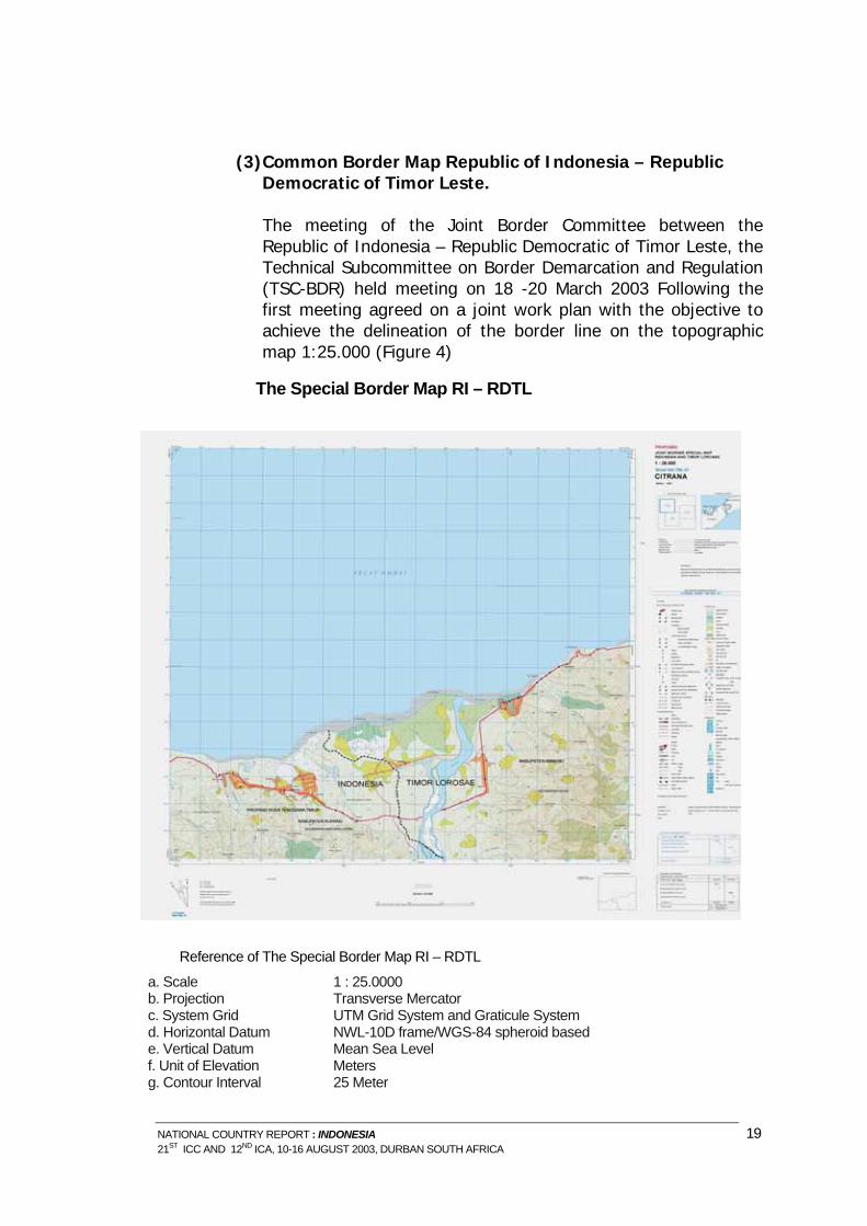
(3) Common Border Map Republic of Indonesia – Republic
Democratic of Timor Leste. The meeting of the Joint Border Committee between the Republic of Indonesia – Republic Democratic of Timor Leste, the Technical Subcommittee on Border Demarcation and Regulation (TSC-BDR) held meeting on 18 -20 March 2003 Following the first meeting agreed on a joint work plan with the objective to achieve the delineation of the border line on the topographic map 1:25.000 (Figure 4)
The Special Border Map RI – RDTL
Reference of The Special Border Map RI – RDTL a. Scale 1 : 25.0000 b. Projection Transverse Mercator c. System Grid UTM Grid System and Graticule System d. Horizontal Datum NWL-10D frame/WGS-84 spheroid based e. Vertical Datum Mean Sea Level f. Unit of Elevation Meters g. Contour Interval 25 Meter
NATIONAL COUNTRY REPORT : INDONESIA 19 21ST ICC AND 12ND ICA, 10-16 AUGUST 2003, DURBAN SOUTH AFRICA
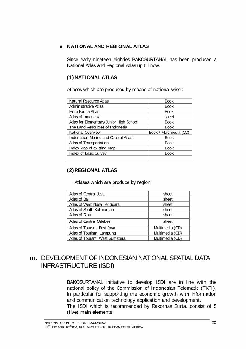
e. NATIONAL AND REGIONAL ATLAS
Since early nineteen eighties BAKOSURTANAL has been produced a National Atlas and Regional Atlas up till now.
(1) NATIONAL ATLAS
Atlases which are produced by means of national wise :
Natural Resource Atlas Book Administrative Atlas Book Flora Fauna Atlas Book Atlas of Indonesia sheet Atlas for Elementary/Junior High School Book The Land Resources of Indonesia Book National Overview Book / Multimedia (CD) Indonesian Marine and Coastal Atlas Book Atlas of Transportation Book Index Map of existing map Book Index of Basic Survey Book
(2) REGIONAL ATLAS
Atlases which are produce by region:
Atlas of Central Java sheet Atlas of Bali sheet Atlas of West Nusa Tenggara sheet Atlas of South Kalimantan sheet Atlas of Riau sheet
Atlas of Central Celebes sheet
Atlas of Toursm East Java Multimedia (CD) Atlas of Tourism Lampung Multimedia (CD) Atlas of Toursm West Sumatera Multimedia (CD)
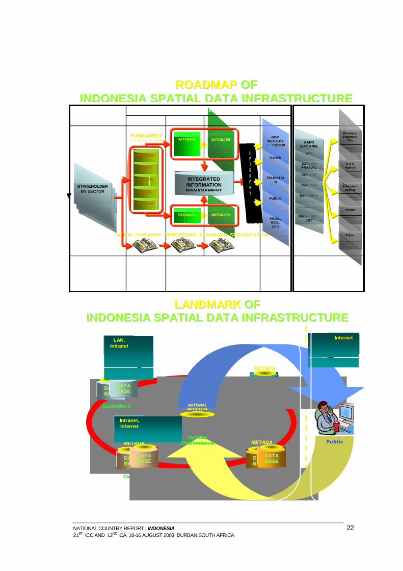
III. DEVELOPMENT OF INDONESIAN NATIONAL SPATIAL DATA INFRASTRUCTURE (ISDI)
BAKOSURTANAL initiative to develop ISDI are in line with the national policy of the Commission of Indonesian Telematic (TKTI), in particular for supporting the economic growth with information and communication technology application and development. The ISDI which is recommended by Rakornas Surta, consist of 5 (five) main elements:
NATIONAL COUNTRY REPORT : INDONESIA 20 21ST ICC AND 12ND ICA, 10-16 AUGUST 2003, DURBAN SOUTH AFRICA
a. institutional aspects; b. legal aspects; c. fundamental data set aspects; d. research and development of science and technology related to
survey and mapping aspects; and e. development of human resource capability aspects. The ISDI is intended to create environment in which all stakeholders using its technology, standards and share geospasial data and information, can corporate and interact with each other to better achieve their objectives at different political/administrative levels. This intention deemed necessary as a mean operationally the Geographic Information System to function as a decision support system for national, regional and local government as well as for greater community, and strongly supports the formation of public information system.
The main constraint envisaged in establishment ISDI are: (1) financial commitment to the availability of continuous funding; (2) the problem of digital divide, e.g.: the have and the have not
access to internet; and (3) GIS have not yet become government technology.
The development of the ISDI is implemented in various initiative programs. In order to socialize the progress and solve the problems relating to the development of ISDI, a coordination meeting rogram called Coordination Meeting on Indonesian Spatial Data infrastructure (Rapat Koordinasi Infrastruktur Data Spasial Nasional) is conducted every year. All representatives of ISDI stakeholders are invited to the meeting, and the member of the steering committee consist of the stakeholder’s representative. The resolution and recommendation resulted from the meeting are implemented by working groups appointed by the meeting. There several working groups established they are : 1). Working Group I : institutional and legal aspects; 2). Working Group II : fundamental dataset aspect; and 3). Working Group III : research and development of science and technology, and human resources aspect.
The significant result of the ISDI is the development of on-line mapping in BAKOSURTANAL website, where internet user may browse topographic data of Indonesia at scale of 1:1,000,000. This development forms as a first step to further development of the Indonesian Asia Pacific Spatial Data Infrastructure node.
NATIONAL COUNTRY REPORT : INDONESIA 21 21ST ICC AND 12ND ICA, 10-16 AUGUST 2003, DURBAN SOUTH AFRICA
METADATA
DATABASE
NATIONAL SYSTEM DEVELOPMENT 2001-2004
YEAR - 1 YEAR - 2 YEAR - 3
System maintenance and development to be conducted through out joint effort among spatial data and information
centers
• Establishment of integrated distributed databases system • Development of web based applications for data and
information dissemination, access and distribution • Expansion of participating agencies/ communities
• Establishment of spatial database
• Development of digital catalog
• Setting up clearinghouse mechanism
Spatial data and information producers (e.g. National Land Agency (BPN), Dep. of Public Work (Kimpraswil), Dep. of Forestry (Dephut), Dept. of Agriculture (Deptan), Dept. of Energy and Mineral Resources, (Dep. ESDM), Universities.
NATIONAL COUNTRY REPORT : INDONESIA 22 21ST ICC AND 12ND ICA, 10-16 AUGUST 2003, DURBAN SOUTH AFRICA
The last coordination meeting was held in Yogyakarta on 5 – 6 August 2003, the result of this meeting are as follow : 1. The recommendations:
a. Some institutions to be added at the working group 211S b. Socialisation Strengthening c. Address of clearing house of each institution d. Elaborate the agreement between institution e. Provide the Law for NSDI (RUU) f. Develop E-Government g. Provide strategic planning and action plan h. Provide National Standard for NSDI i. Established standard for protocol and data exchange
2. The Programs:
a. Working Group I : Institutional and legal aspect: i. Conduct a coordination meeting at the level of province,
district, and municipal ii. Inventory and evaluate norm and procedure of
standadization iii. Established sub working group based on necessity approach iv. Find out specific issues on its rule of the law v. Improve coordination with Finance Departement
b. Working Group II: Fundamental data set aspect
i. Set up a sectoral data set and data set integration ii. Develop data dictionary iii. Provide a procedure for data qualification at the clearing
house iv. Build up a pilot project
c. Working Group II: Research and development of science and
technology, and human resource aspect i. Provide standardization of data acquisition, data visualization
and data distribution ii. Provide standardization of data exchange and protocol iii. Expand collaboration between government with NGO,
private company, association/profession, to carry out education and traning
iv. Improve data directory and national spatial information which has already been set up.
NATIONAL COUNTRY REPORT : INDONESIA 23 21ST ICC AND 12ND ICA, 10-16 AUGUST 2003, DURBAN SOUTH AFRICA
IV. EDUCATION AND TRAINING
a. EDUCATION
Program study of Cartography in Indonesia only a few, one placed in the Unversity of Gadjah Mada under the Faculty of Geography and other in the Institute Technology Bandung (ITB) under Department of Geodesy. The majority of Cartography lectures were taking a post graduate course at International Institute for Earth Science / ITC – The Netherlands. On 1976 BAKOSURTANAL, ITB and ITC established a Photogrametry and Cartography Training Center located at Bandung Institute of Technology, but this center already closed since 1986. Then also established a Center for Image Interpretation located at Faculty of Geography Gadjah Mada University in Yogyakarta, still running up to now.
b. TRAINING
i. Training Center activities in BAKOSURTANAL
This center has established since 1986, it has several programs : training on Geographical Information System and Remote Sensing Application, Positioning with GPS, Digital Cartography, Bathymetric survey, course in determination of border survey, etc The participants are coming from national and international level. For national level, can be individual from difference office or a group from the same office. In favor of International level, usually manage by State of Secretariat RI and the United Nation. The detail is follow: a. Technical Cooperation Among Developing Countries (TCDC)
The TCDC training course under sponsorship of UN-ESCAP and the Government of Republic of Indonesia is addressed for the junior staff from Asia Pacific developing countries who involved in mapping, digital image processing system activities towards land use mapping or natural resources management. The aims of this course are to provide participants with a theoretical background and practical skill in using Geographic Information System (GIS) and Remote Sensing (RS) technologies for land use mapping and identifying the appropriate information required by planners and decision-markers in regard to develop the sustainable land use management.
NATIONAL COUNTRY REPORT : INDONESIA 24 21ST ICC AND 12ND ICA, 10-16 AUGUST 2003, DURBAN SOUTH AFRICA
The course title for this year is Remote Sensing and Geographic Information System Technologies for Integrated Land and Water Resources Management and it has started on June 16 2003. Twelve participants respectively from Bangladesh, Cambodia, Fiji, Lao PDR, Mongolia, Nepal, Samoa, Vietnam, Myanmar, Indonesia have joint for this course for two months. The course is conducted in two places and divided into two sessions. The first session is carrying out at BAKOSURTANAL Cibinong. Participants were provided to the basic concepts of surveying and mapping, including Remote Sensing, Geographic Information System, Global Positioning System (GPS) and Digital Cartography. In the second session will be conducted in PUSPICS-UGM Yogyakarta, and they were provided with earth sciences and the application of RS and GIS.
b. Others training course in surveying and mapping in
BAKOSURTANAL are addressed for local staff only.
Several topic of the training are being introduced. For examples: Training course in GIS and Remote Sensing, Positioning with GPS, Digital Cartography, Bathymetric survey, course in determination of border survey, etc. The course duration of each title has about 10 – 20 days. The participants are mainly from local government staff (province, district, etc), the others are from central government and BAKOSURTANAL staff as well. The majority of lecturer of the course originate from BAKOSURTANAL staff.
ii. Education Center for Satellite Image Interpretation (PUSPICS)
PUSPIC, Stands for Pusat Pendidikan Interprestasi Citra Satelit or Education Center for Satelite Images Interpretation was established in 1983, and is situated at the faculty of Geography University of Gajah Mada, Yogyakarta. The center has been actively involed in providing training and building cooperation with other institution nationally and internationally. To date, PUSPIC has trained quite a number of people in form of :
o Regular Training : 429 participants o Training center for development countries : 92 participants o Non-regular training : 628 participants
V. ASSOCIATION
a. The Association of Indonesia Cartography (AIC)
NATIONAL COUNTRY REPORT : INDONESIA 25 21ST ICC AND 12ND ICA, 10-16 AUGUST 2003, DURBAN SOUTH AFRICA
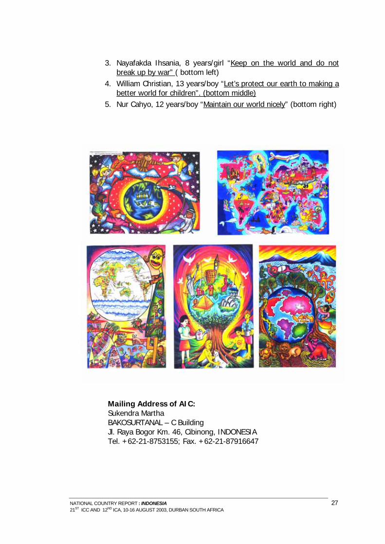
On December 1, 1999 a number of cartographer and cartographic product user gathered and agreed to form a professional and organization in cartography. The name of that profession organization is Associations of Indonesian Cartography. At this moment member of that organization is more than a 100 member. They originated from various organizations both government and non-government. The Association of Indonesia Cartography (AIC) in Indonesian is Asosiasi Kartografi Indonesia (AKI) has 6 working groups: Toponimy, Cartographic Database, Cartographic Visualization, Atlas, Public Map, Training and Cartographic Socialization. For the first term (2000-2003) Al Susanto from BAKOSURTANAL chaired the association accompanied by Hadwi Soendjojo from Bandung Institute of Technology as the Secretary General. Several programs have been formulated, one of the programs is the improvement of The Association of Indonesia Cartography (AIC). For this matter AIC already held a workshop on 22 March 2000. AIC would like to communicate with similar international organization such as International Cartographic Association (ICA). There was a first initiation meeting on January 2003 between BAKOSURTANAL and the AIC with the Secretary General of ICA, Prof Ormeling to discuss about the possibility to correspond the association. At the same time, AIC organized a congress and seminar at BAKOSURTANAL. Prof Ormeling, the Secretary General of ICA, was invited by the former President of AIC to give a main presentation concerning the developing of ICA and ICA profile. In the afternoon, The new President of AIC selected by the AIC members for the second period (2003-2005) is Drs. Sukendra Martha, M.Sc, M.AppSc. and the Secretary General is Dr. Riadika Mastra, M.Sc. The first program of the new AIC board together with BAKOSURTANAL, as ICA offered, create a National Map Drawing Competition which is the five nominations will be compete on ICA event (Internationally) to win Barbara Petchenick Award. The committee for National map drawing competition never expected that the number of participant will be beyond expectation. And the Jurors found very difficult to select the drawings, because their imagination are so surprising , the color also so beautiful and matching appearance. Nevertheless, The Jurors have decided a nominations are as follow : 1. Anggi Dito Dwi Septian, 8 years/boy, “Together forever save the
earth”, (up left) 2. Ferina, 13 years/boy “My World is colorful and beauty” (up right)
NATIONAL COUNTRY REPORT : INDONESIA 26 21ST ICC AND 12ND ICA, 10-16 AUGUST 2003, DURBAN SOUTH AFRICA
3. Nayafakda Ihsania, 8 years/girl “Keep on the world and do not break up by war” ( bottom left)
4. William Christian, 13 years/boy “Let’s protect our earth to making a better world for children”. (bottom middle)
5. Nur Cahyo, 12 years/boy “Maintain our world nicely” (bottom right)
Mailing Address of AIC: Sukendra Martha BAKOSURTANAL – C Building Jl. Raya Bogor Km. 46, Cibinong, INDONESIA Tel. +62-21-8753155; Fax. +62-21-87916647
NATIONAL COUNTRY REPORT : INDONESIA 27 21ST ICC AND 12ND ICA, 10-16 AUGUST 2003, DURBAN SOUTH AFRICA
b. The Indonesian Surveyors Association (ISA)
Indonesian Surveyors Association (ISA) is the English term for the Ikatan Surveyor Indonesia (ISI) which has been established since 1972. The association has more than 1000 members, but only about one fourth of them are active members. ISA members consisted of expert and skill level of qualification. University graduates from geodetic department are considered as Expert, while Diploma holders in surveying from secondary and vocational education level are qualified as skill level. According to its new statuta, the Management Board of ISA has 3 years period of service, and its President and Vice are elected by the ISA Congress. The last ISA Congress was held in Yogyakarta, October 2002 elected the new President and Vice President to form the new Management Board of ISA for the period 2002 – 2005. Dr. Sobar Sutisna was elected as the New President, and Dr. Irawan Sumarto is the Vice President. In this report, ISA as one of the Indonesian country societies in surveying and mapping, present its brief report as follow. a. The 2002-2005 ISA Management Board President of the
Association (ISA) : Dr. Sobar Sutisna Vice President : Dr. Irawan Sumarto Secretary General : Mr. G. Haryuatmanto Treasurer and Vice : Mr. Ronny K.Y. and Mrs. Diah K.
Kresnawati Board Members : Mr. Rachmansyah - Chairman
Mr. Sugeng Priyadi – Chairman Dr. Hasanuddin Z. Abidin - Chairman Dr. Subaryono – Chairman
Mr. Saidi Pranoto – Chairman Director for ISA 2005 Congress : Mr. D.K. Sunaryo
b. ISA Mailing Address :
1. Dr. Sobar Sutisna BAKOSURTANAL – H Building Jl. Raya Bogor Km. 46, Cibinong, INDONESIA Tel.&Fax.+62-21-8754654
2. Dr. Irawan Sumarto Dept. Geodesi ITB Jl. Ganesha 10, Bandung, INDONESIA
NATIONAL COUNTRY REPORT : INDONESIA 28 21ST ICC AND 12ND ICA, 10-16 AUGUST 2003, DURBAN SOUTH AFRICA
c. ISA Programs and Activities • Certification of surveyors has been carried out since 2001. • Training is meant to maintain professional qualification. This is
conducted in cooperation with surveying industries, universities and government institution in the country.
• International cooperation with similar organization is very important at a regional and global level. ISA is a member of the International Federation of Surveyors (FIG), International Surveying, Photogrammetry and Remotesensing Society (ISPRS), and ASEAN Federation of Land Administration and Geomatic Surveying (A-FLAGS). In cooperation with FIG, the 3 rd Regional Conference of FIG is plan to be held in Indonesia, October 2004. Member countries are very welcome to joint. _ Seminars in the fields of land surveying, geodetic surveying, GPS, GIS, cadastral, and engineering surveying are carried out in the country in cooperation with other associations and government agency. _ Scientific meeting of ISA is held in October every year. C. Tentative Agenda for the Preparation of FIG Regional Conference in Indonesia In a preparation stage, FIG and ISA and BAKOSURTANAL have agree on the following agenda of preparation for the FIG Regional Conference: • Mid July 2003, Signing of Agreement FIG-ISI-BAKO • Early Aug 2003, Report to FIG Consul • Early Sep 2003, Website establishment • Early Dec 2003, Call for papers • Early Feb 2004, First Circular • Mid May 2004, FIG Annual Meeting • End May 2004, Abstracts • End Aug 2004, Full papers • 3-7 Oct 2004 , FIG Regional Conference ISA and BAKOSURTANAL will be the Local Host for the FIG Regional Conference
d. Indonesian Society for Remote Sensing (ISRS)
ISRS on Indonesian “Masyarakat Penginderaan Jauh Indonesia (MAPIN)” was established on 20 July 1990, it also has more than 1000 members. The last ISRS Congress (III) was held in Bandung on July 2003 elected the new President and Secretary General to form the new managemant for 2003-2006. The president of ICRS is Drs. Bambang S. Tejasukmana Dipl.Ing. and the Secretary General is Dr. Ir. Ketut Wikantika. Mailing Address of AIC:
National Institution for aeronatic and Space (LAPAN) Tel. +62-21-4894989 ; Fax. +62-21- 4894815
NATIONAL COUNTRY REPORT : INDONESIA 29 21ST ICC AND 12ND ICA, 10-16 AUGUST 2003, DURBAN SOUTH AFRICA
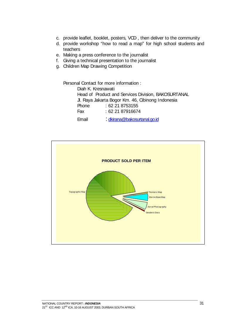
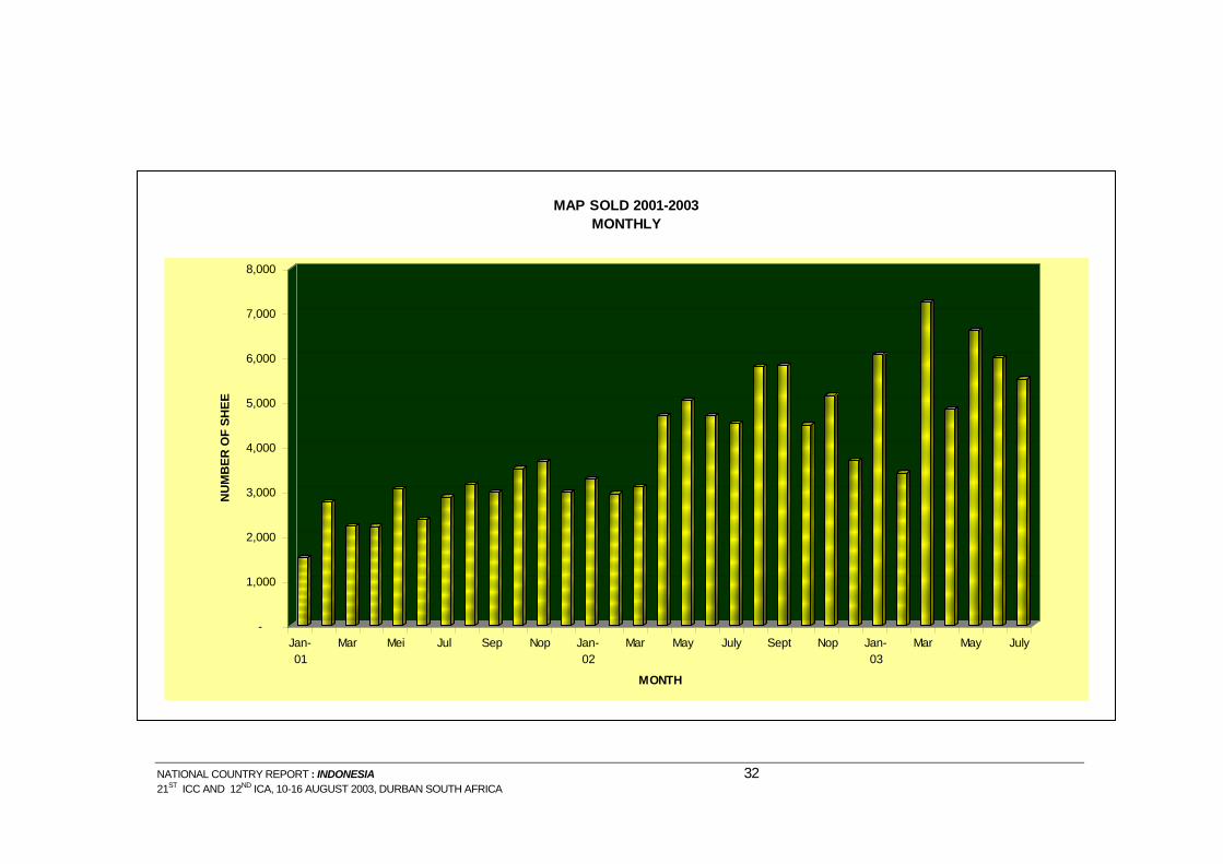
VI. MAPPING AWARENESS People in Indonesia has realized that map is an important information for human life purposes. Man needs a map, has been rise up very good every year, for the last five years, this can be seen from the amount of BAKOSURTANAL product has been sold nowadays, and some maps produced by private company also display mostly on a well known bookshop in Indonesia. Since year 2001, BAKOSURTANAL has established a new center called : Center for Information and Services. The center has several tasks e.g.: 1. to disseminate information and knowledge of surveys and mapping to
the community, local and central government, etc. 2. to promote BAKOSURTANAL products and other services 3. to sell the BAKOSURTANAL products through some outlets 4. to facilitate local and central government concerning the demand of
spatial data. BAKOSURTANAL provides several services for map order: by letter, by phone, by email, and in site. We also facilitate a delivery services, although this is depend on the users which services to be used for his order. Everyday, we obtain at least 15 orders/visitors; it comes from so many part of Indonesia. They come to BAKOSURTANAL shop, not only buying a map, but also need get more information about other BAKOSURTANAL product possibilities, etc. For this year, we sell more than 4000 sheets of map each month either in printed map or dijital data. But mainly they still prefer using a printed map than digital data. This is because using a digital data need more investment on equipment and human resource development which are not inexpensive. At least, along with the development of information technology the digital data will used automatically. Furthermore, since the Law of Authonomy in Indonesia has been started, most of the local government realized that map are very important as a base information to develop their own region, consequently they ask BAKOSURTANAL to assist local government to provide a spatial data. One of them is from Kabupaten Ciamis, BAKOSURTANAL developed a Laboratory for Kabupaten Data Center, provide a set of GIS equipments and its peripherals, set of spatial data available and trained their staff. Some activities to rice up mapping awareness : a. setting up an exhibition for promoting BAKOSURTANAL product b. provide presentation by visiting some provinces through local meeting
NATIONAL COUNTRY REPORT : INDONESIA 30 21ST ICC AND 12ND ICA, 10-16 AUGUST 2003, DURBAN SOUTH AFRICA
NATIONAL COUNTRY REPORT : INDONESIA 31 21ST ICC AND 12ND ICA, 10-16 AUGUST 2003, DURBAN SOUTH AFRICA
c. provide leaflet, booklet, posters, VCD , then deliver to the community d. provide workshop “how to read a map” for high school students and
teachers e. Making a press conference to the journalist f. Giving a technical presentation to the journalist g. Children Map Drawing Competition
Personal Contact for more information :
Diah K. Kresnawati Head of Product and Services Division, BAKOSURTANAL Jl. Raya Jakarta Bogor Km. 46, Cibinong Indonesia Phone : 62 21 8753155 Fax : 62 21 87916674
NATIONAL COUNTRY REPORT : INDONESIA 32 21ST ICC AND 12ND ICA, 10-16 AUGUST 2003, DURBAN SOUTH AFRICA
END USERS OF BAKOSURTANAL PRODUCT
PrivateCentral Gov.
Local Gov.
Research
Individual
NATIONAL COUNTRY REPORT : INDONESIA 33 21ST ICC AND 12ND ICA, 10-16 AUGUST 2003, DURBAN SOUTH AFRICA
VII. CONTRIBUTING AUTHOR The National Coordinating Agency for Surveys and Mapping highly appreciate the contribution from various authors in the compilation of this report. The following is the list of those who have contributed:
o Rudolf W. Matindas, et al., National Coordinating Agency for Surveys and Mapping
o Drs. Mas Sukoco, Faculty of Geography, Program Study Cartography and Remote Sensing, University of Gajah Mada, Yogyakarta
o Diah K. Kresnawati and Heru Warsito, National Coordinating Agency for Surveys and Mapping
o Nurwajedi, et al., National Coordinating Agency for Surveys and Mapping o Dodi Sukmayadi and Agus Priyanto, National Coordinating Agency for
Surveys and Mapping o Agus Santoso, et al., National Coordinating Agency for Surveys and
Mapping o Al Sumarso, et al. National Coordinating Agency for Surveys and Mapping o Sobar Sutisna, Dr., et al., National Coordinating Agency for Surveys and
Mapping, Indonesian Surveyor Association o S.S.O. Poentodewo, Dr., Sri K. Gularso, and B. Purnawan, National
Coordinating Agency for Surveys and Mapping
o Asadi, et al., National Coordinating Agency For Surveys and Mapping
VIII. FURTHER INFORMATION
For further information concerning this report please contact :
Rudolf W. Matindas Chairman of National Coordinating Agency for Surveys and Mapping Jl. Raya Jakarta – Bogor, Km.46, CIBINONG 16911, Indonesia Phone : +62 21 875 4592 Fax : +62 21 875 2064, 875 4592 e-mail : [email protected] website : www.bakosurtanal.go.id
NATIONAL COUNTRY REPORT : INDONESIA 35 21ST ICC AND 12ND ICA, 10-16 AUGUST 2003, DURBAN SOUTH AFRICA