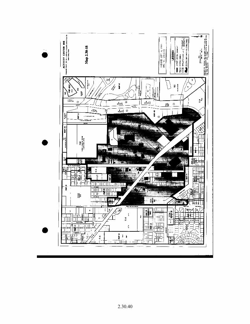
2.30.1 2.30 Urban Development Pattern – Urban Residential Fringe Subdistrict & Activity Center Subdistricts A. Introduction & Background: Collier County has directly quoted from the Future Land Use Element, Urban Commercial District, Mixed Use Activity Center Subdistrict, to provide the context of the overall goal of this subdistrict to accommodate almost all new commercial zoning within a mixed-use environment: “Mixed Use Activity Centers have been designated on the Future Land Use Map Series and identified in the Future Land Use Element. The locations are based on intersections of major roads and on spacing criteria. There are 19 Mixed Use Activity Centers, which comprise approximately 3,000 acres, including 3 Interchange Activity Centers (4, 9, 10) that will be discussed separately. Two Activity Centers #19 and #21 have been deleted and replaced by the land use designations identified in the Marco Island Master Plan and Future Land Use Map.” Please refer to Map 2.30-1. Map 2.30-1:
Transcript
2.30.1
2.30 Urban Development Pattern – Urban Residential Fringe Subdistrict & Activity Center Subdistricts
A. Introduction & Background: Collier County has directly quoted from the Future Land Use Element, Urban Commercial District, Mixed Use Activity Center Subdistrict, to provide the context of the overall goal of this subdistrict to accommodate almost all new commercial zoning within a mixed-use environment:
“Mixed Use Activity Centers have been designated on the Future Land Use Map Series and identified in the Future Land Use Element. The locations are based on intersections of major roads and on spacing criteria. There are 19 Mixed Use Activity Centers, which comprise approximately 3,000 acres, including 3 Interchange Activity Centers (4, 9, 10) that will be discussed separately. Two Activity Centers #19 and #21 have been deleted and replaced by the land use designations identified in the Marco Island Master Plan and Future Land Use Map.” Please refer to Map 2.30-1.
Map 2.30-1:
2.30.2
“The Mixed-Use Activity Center concept is designed to concentrate almost all new commercial zoning in locations where traffic impacts can readily be accommodated, to avoid strip and disorganized patterns of commercial development, and to create focal points within the community. Furthermore, Mixed Use Activity Centers are intended to be mixed-use in character. The actual mix of the various land uses - which may include the full array of commercial uses, residential uses, institutional uses, hotel/motel uses at a density consistent with the Land Development Code – shall be determined during the rezoning process based on consideration of the factors listed below. For residential development, if a project is within the boundaries of a Mixed Use Activity Center, which is not within the Urban Residential Fringe Subdistrict or Urban Coastal Fringe Subdistrict, up to 16 residential units per gross acre may be permitted. This density may be distributed throughout the project, including any portion located outside of the boundary of the Mixed Use Activity Center. Mixed-use developments - whether consisting of residential units located above commercial uses, in an attached building, or in a freestanding building - are allowed. Such mixed-use projects are intended to be developed at a human-scale, pedestrian-oriented, and interconnected with adjacent projects – whether commercial or residential. Street, pedestrian pathway and bike lane interconnections with adjacent properties, where possible and practicable, are encouraged. Density is calculated based upon the gross project acreage within the Activity Center. If such a project is located within the boundaries of Mixed Use Activity Center, which is not within the Urban Residential Fringe Subdistrict and is not within the Coastal High Hazard Area, the eligible density is sixteen dwelling units acre. If such a project is located within the boundaries of a Mixed Use Activity Center that is not within the Urban Residential Fringe Subdistrict but is within the Coastal High Hazard Area, the eligible density shall be limited to four dwelling units per acre. If such a project located within the boundaries of a Mixed Use Activity Center that is within the Urban Residential Fringe Subdistrict, eligible density shall be as allowed by that Subdistrict. The factors to consider during review of a rezone petition are as follows:
• Rezones within Mixed Use Activity Centers are encouraged to be in the form of a Planned Unit Development. There shall be no minimum acreage limitation for such Planned Unit Developments except all requests for rezoning must meet the requirements for rezoning in the Land Development Code.
• The amount, type and location of existing zoned commercial land, and
developed commercial uses, within the Mixed Use Activity Center and within two road miles of the Mixed Use Activity Center
• Market demand and service area for the proposed commercial land uses to
be used as a guide to explore the feasibility of the requested land uses
2.30.3
• Existing patterns of land use within the Mixed Use Activity Center and
within two radial miles
• Adequacy of infrastructure capacity, particularly roads
• Compatibility of the proposed development with, and adequacy of buffering for, adjoining properties
• Natural or man-made constraints
• Rezoning criteria identified in the Land Development Code
• Conformance with Access Management Plan provisions for Mixed Use
Activity Centers contained in the Land Development Code
• Coordinated traffic flow on-site and off-site, as may be demonstrated by a Traffic Impact Analysis, and a site plan/master plan indicating on-site traffic movements, access point locations and type, median opening locations and type on the abutting roadway(s), location of traffic signals on the abutting roadway(s), and internal and external vehicular and pedestrian interconnections
• Interconnection(s) for pedestrians, bicycles and motor vehicles with
existing and future adjacent projects
• Conformance with the architectural design standards as identified in the Land Development Code.
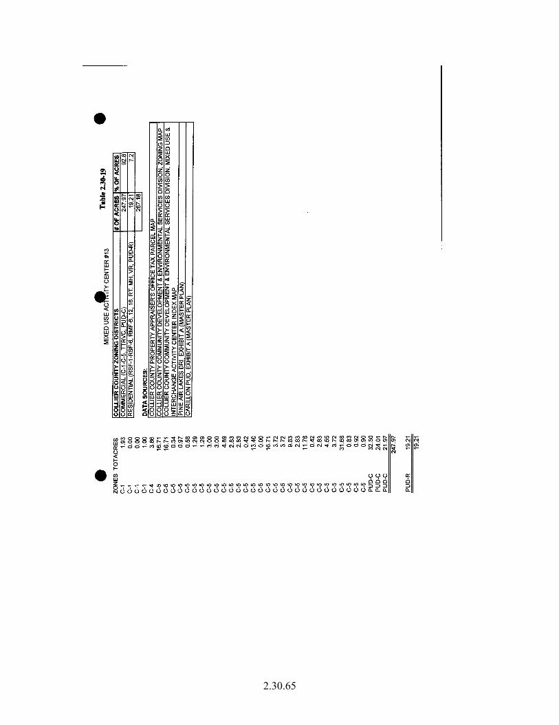
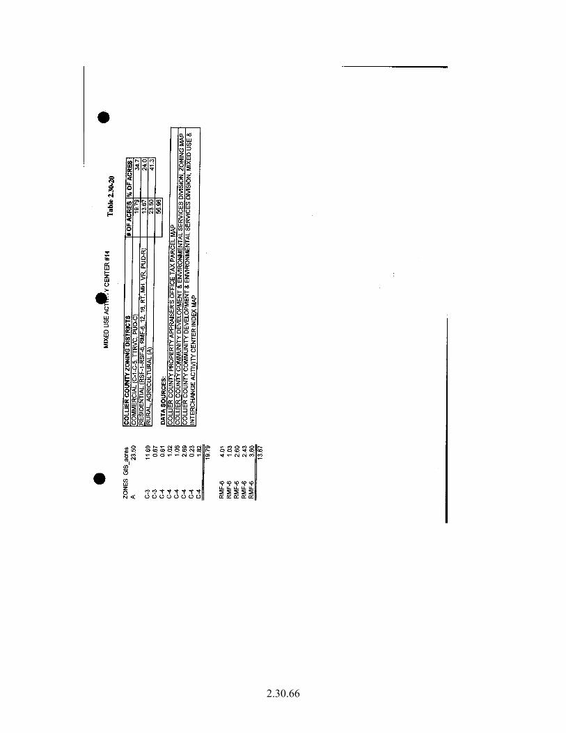
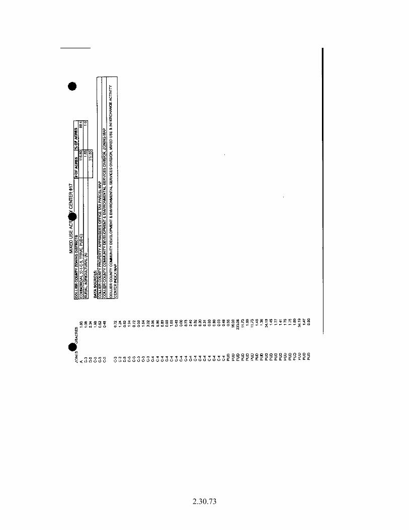
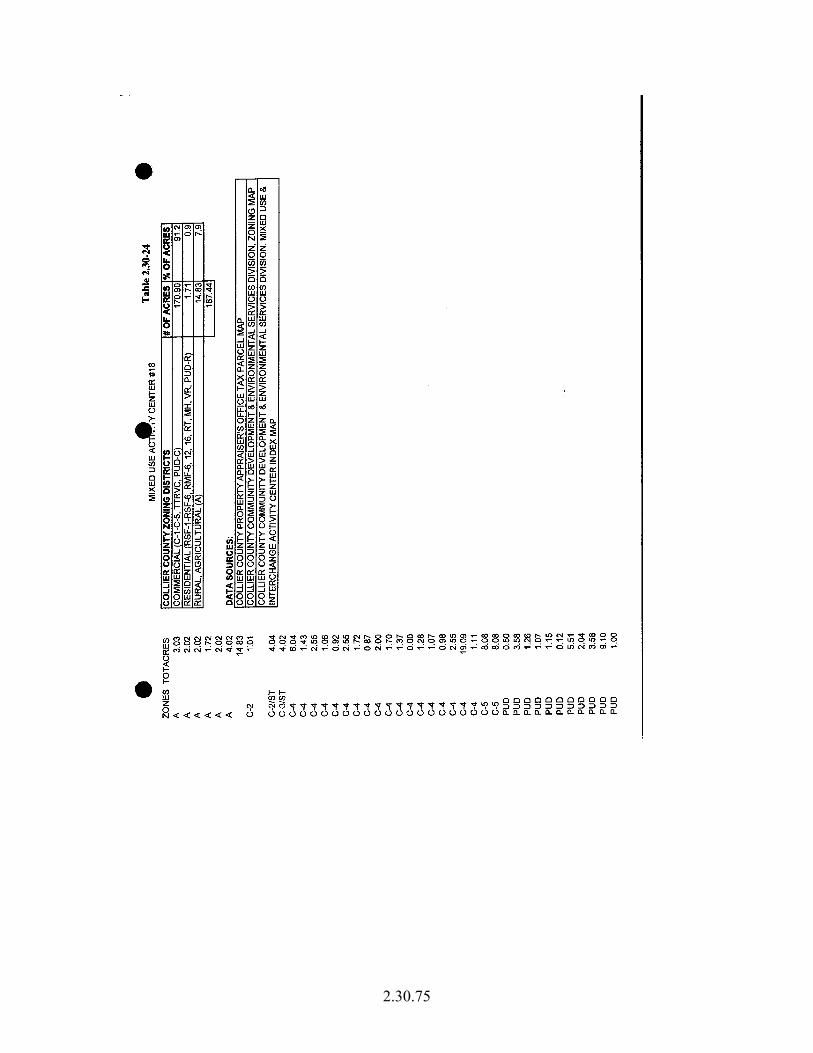
The approximate boundaries of Mixed Use Activity Centers have been delineated on the maps located at the end of this section as part of the Future Land Use Map Series. The actual boundaries of Mixed Use Activity Centers listed below by Activity Center and location are specifically defined on the maps and shall be considered to delineate the boundaries for those Mixed Use Activity Centers. # 1 Immokalee Road and Airport Road # 6 Davis Boulevard and Santa Barbara Boulevard # 8 Airport Road and Golden Gate Parkway #11 Vanderbilt Beach Road and Airport Road #12 US 41 and Pine Ridge Road #13 Airport Road and Pine Ridge Road #15 Golden Gate Parkway and Coronado Boulevard #16 US 41 and Airport Road #17 US 41 and Rattlesnake-Hammock Road #18 US 41 and Isles of Capri Road #20 US 41 and Wiggins Pass Road
2.30.4
The mix of uses in all of these specifically designated, except for #6 at Davis Boulevard and Santa Barbara Boulevard, range from 80 to 100% commercially zoned and/or developed property. Activity Center #6 is approximately 60% commercially zoned and/or developed. For purposes of these specifically designated Activity Centers, the entire Activity Center is eligible for up to 100%, or any combination thereof, of each of the following uses: commercial, residential and/or community facilities. Mixed Use Activity Centers may be designated as Master Planned Mixed Use Activity Centers. Master Planned Mixed Use Activity Centers are those, which have a unified plan of development in the form of a Planned Unit Development, Development of Regional Impact or an area-wide Development of Regional Impact. Property owners within Mixed Use Activity Centers shall be required to utilize the Master Planned Mixed Use Activity Center process. # 2 US 41 and Immokalee Road # 3 Immokalee Road and CR 951 # 5 US 41 and Vanderbilt Beach Road # 7 Rattlesnake-Hammock Road and CR 951 #14 Goodlette-Frank Road and Golden Gate Parkway In recognition of the benefit resulting from the coordination of planned land uses and coordinated access points to the public road network, Master Planned Activity Centers are encouraged through the allowance of flexibility in the boundaries, mix and location of uses permitted within a designated Mixed Use Activity Center and may be permitted to modify the designated configuration. The boundaries of Master Planned Mixed Use Activity Centers depicted on the Future Land Use Map Series are understood to be flexible and subject to modification during final site design; however, the approved amount of commercial development shall not be exceeded. The actual mix of land uses shall be determined using the criteria for other Mixed Use Activity Centers. All of the following criteria must be met for a project to qualify as a Master Planned Mixed Use Activity Center: 1. The applicant shall have unified control of the majority of a quadrant in a designated Activity Center. Majority of the quadrant shall be defined as at least 51% of the privately owned land within any Activity Center quadrant. However, if a property owner has less than 51% ownership within a quadrant, that property owner may still request a rezoning under the provisions of a Mixed Use Activity Center Subdistrict subject to the maximum acreage allowed in Paragraph 2 below. Property owners with less than 51% ownership are encouraged to incorporate vehicular and pedestrian accesses with adjacent properties within the Activity Center. Any publicly owned land within the quadrant will be excluded from acreage calculations to determine unified control;
2.30.5
2. The permitted land uses for a Master Planned Mixed Use Activity Center shall be same as for designated Activity Centers; however, a Master Planned Mixed Use Activity Center encompassing the majority of property in two or more quadrants shall be afforded the flexibility to redistribute a part or all of the allocation from one quadrant to another. The maximum amount of commercial uses permitted at Activity Center # 3 is 40 acres per quadrant for a total of 160 acres maximum in the entire Activity Center; the balance of the land area shall be for residential and/or community facility uses. The maximum amount of commercial uses permitted at Activity Center #7 is 40 acres per quadrant, except that the northeast quadrant may have a total of 59 acres, for a total of 179 acres maximum in the entire Activity Center; the balance of the land area shall be for residential and/or community facility uses. With respect to the +/- 19 acres in the northeast quadrant of Activity Center #7, said acreage lying adjacent to the east of the Hammock Park Commerce Center PUD, development shall be limited to a total of 185,000 square feet of the following uses: personal indoor self-storage facilities – this use shall occupy no greater than 50% of the total (185,000) building square feet; offices for various contractor/builder construction trade specialists inclusive of the offices of related professional disciplines and services that typically serve those construction businesses or otherwise assist in facilitating elements of a building and related infrastructure, including but not limited to architects, engineers, land surveyors and attorneys – these offices of related professional disciplines and services shall occupy no greater than 50% of the total (185,000) building square feet; warehouse space for various contractor/builder construction trades occupants; mortgage and land title companies; related businesses including but not limited to lumber and other building materials dealers, paint, glass, and wallpaper stores, garden supply stores – all as accessory uses only, accessory to offices for various contractor/builder construction trade specialists or accessory to warehouse space for various contractor/builder construction trades occupants; management associations of various types of buildings or provision of services to buildings/properties; and, fitness centers. Activity Center #14 shall have a maximum of 45 acres for commercial use, the balance of the land uses shall be for residential and/or community facility uses. Activity Centers #2 and #5 have approximately 80% of the area zoned or developed for commercial uses. For purposes of these two Activity Centers, the entire Activity Center is eligible for up to 100% or any combination thereof, of the following uses: commercial, residential and/or community facilities. 3. The location and configuration of all land uses within a Master Planned Mixed Use Activity Center shall be compatible with and related to existing site Features, surrounding development, and existing natural and manmade constraints. Commercial uses shall be oriented so as to provide coordinated and functional transportation access to major roadways serving the Activity Center, and functionally related or integrated with surrounding land uses and the planned transportation network; and
2.30.6
4. Adjacent properties within the Activity Center that are not under the unified control of the applicant shall be considered and appropriately incorporated (i.e. pedestrian and vehicular interconnections) into the applicant’s Master Plan. New Mixed Use Activity Centers may be proposed if all of the following criteria are met and an amendment is made to delineate the specific boundaries on the Future Land Use Map series for Mixed Use Activity Centers: • The intersection around which the Mixed Use Activity Center is located
consists of an arterial and collector road, or two arterial roads, based upon roadway classifications in the Traffic Circulation Element.
• The Mixed Use Activity Center is no closer than two miles from any
existing Mixed Use Activity Center, as measured from the center point of the intersections around which the existing and proposed Mixed Use Activity Centers are located.
• Market justification is provided demonstrating need for a Mixed Use
Activity Center at the proposed location.” Collier County has directly quoted from the Future Land Use Element, Urban Commercial District, Interchange Activity Center Subdistrict, to provide the context of the overall goal of this subdistrict to accommodate almost all new commercial zoning within a mixed-use environment:
“Interchange Activity Centers have been designated on the Future Land Use Map at each of the three Interstate 75 interchanges and include numbers 4, 9 and 10. The boundaries of these Interchange Activity Centers have been specifically defined on the maps located at the end of this Section as part of the Future Land Use Map Series. Any changes to the boundaries of these Interchange Activity Centers shall require an amendment to the Future Land Use Map Series. Interchange Activity Centers #4 and #10 allow for a mixture of land uses - which may include 100% or any combination thereof, of each of the following uses: the full array of commercial uses, residential and non-residential uses, institutional uses, hotel/motel uses at a density consistent with the Land Development Code, and Business Parks; and industrial uses as identified below in the southwest and southeast quadrants of Interchange Activity Center #4. No industrial uses shall be allowed in Interchange Activity Center #10. The actual mix of uses shall be determined during the rezoning process based on consideration of the same factors listed under the Mixed Use Activity Center Subdistrict. Please refer to Map 2.30.2 Interchange Activity Center # 9 shall be subject to the requirement of the development of an Interchange Master Plan (IMP). The IMP is intended to create an enhanced “gateway” to Naples. The IMP process shall be initiated by the property owners and/or their representatives by meeting with the County planning
2.30.7
staff within 60 days of the adoption of this Growth Management Plan amendment and a finding of compliance from the Department of Community Affairs. The purpose of the meeting will be to establish a mutually acceptable vision statement for Activity Center # 9. The Interchange Master Plan shall be adopted by Resolution by the Board of County Commissioners. All rezones thereafter shall meet the intent of the vision statement. Subsequent to the development of the vision statement, new projects within Activity Center #9 are encouraged to have a unified plan of development in the form of a Planned Unit Development. The mixture of uses allowed in Interchange Activity Center # 9 shall include the full array of commercial uses; residential and non-residential uses; institutional uses; Business Park; hotel/motel uses at a density consistent with the Land Development Code; industrial uses in the northeast, southwest and southeast quadrants. The mix and intensity of land uses shall meet the intent of the vision statement and be defined during the rezoning process. The entire Interchange Activity Center is eligible for up to 100% of the entire acreage to be developed for any of the uses referenced above, except the maximum amount of commercial acreage shall not exceed 55% of the total acreage (632.5 ac.) of Interchange Activity Center # 9. The factors to consider during review of a rezone petition shall be in compliance with the vision statement and those included for the Mixed Use Activity Center. For residential development, if a project is within the boundaries of an Interchange Activity Center, which is not within the Urban Residential Fringe Subdistrict and not within the Estates Designation, up to 16 residential units per gross acre may be permitted. This density may be distributed throughout the project, including any portion located outside of the boundary of the Activity Center. Based on the unique location and function of Interchange Activity Centers, some Industrial land uses that serve regional markets and derive specific benefit when located in the Interchange Activity Centers shall be allowed, provided each such use is reviewed and found to be compatible with existing and approved land uses. Industrial uses shall be limited to: manufacturing, warehousing, storage, and distribution. The following conditions shall be required to ensure compatibility of Industrial land uses with other commercial, residential and/or institutional land uses in the Interchange Activity Centers; to maintain the appearance of these Interchange Activity Centers as gateways to the community; and to mitigate any adverse impacts caused by noise, glare or fumes to the adjacent property owners. The Planned Unit Development and/or rezoning ordinance shall contain specific language regarding the permitted Industrial land uses, compatibility requirements, and development standards consistent with the following conditions. Site-specific development details will be reviewed during the Site Development Plan review Process: • Landscaping, buffering and/or berming shall be installed along the
Interstate;
2.30.8
• Fencing shall be wooden or masonry; • Wholesale and storage uses shall not be permitted immediately adjacent to
the right-of-way of the Interstate; • Central water and sewage systems shall be required; • State Access Management Plans, as applicable; • No direct access to the Interstate right-of-way shall be permitted;
• Joint access and frontage roads shall be established when frontage is not
adequate to meet the access spacing requirements of the Access Control Policy, Activity Center Access Management Plan provisions, or State Access Management Plans, as applicable;
• Access points and median openings shall be designed to provide adequate
turning radii to accommodate truck traffic and to minimize the need for U-turn movements;
• The developer shall be responsible to provide all necessary traffic
improvements – to include traffic signals, turn lanes, deceleration lanes, and other improvements deemed necessary - as determined through the rezoning process;
• A maximum floor area ratio (FAR) for the designated Industrial land uses
component of the projects shall be established at 0.45.”
Collier County has directly quoted from the Future Land Use Element, Urban Mixed Use District, Urban Residential Fringe Subdistrict to provide the context of the overall goal of this subdistrict to provide transitional densities between the Urban Designated Area and the Agricultural/Rural Area:
The purpose of this Subdistrict is to provide transitional densities between the Urban Designated Area and the Agricultural/Rural Area and comprises approximately 5,500 acres and 5% of the Urban Mixed Use District. Residential land uses may be allowed at a maximum density of 1.5 units per gross acre, or up to 2.5 units per gross acre via the transfer of up to one dwelling unit per acre from lands designated as Rural Fringe Mixed Use District Sending or, in the case of properties specifically identified below, a density bonus of up to 6.0 additional units per gross acre may be requested for projects providing affordable housing (home ownership only) for low and moderate income residents of Collier County, pursuant to Section 2.7.7 of the Land Development Code, or its successor ordinance, except as provided for in paragraph “c” below. Within the Urban Residential Fringe, rezone requests are not subject to the density rating system,
2.30.9
except as specifically provided in c. below, but are subject to the following conditions: a. All rezones are encouraged to be in the form of a planned unit development; b. Proposed development in the area shall be fully responsible for all necessary
water management improvements, including the routing of all on-site and appropriate off -site water through the project’s water management system, and a fair share cost of necessary improvements to the CR 951 canal/out-fall system made necessary by new development in the area; and,
c. Properties eligible for the Affordable Housing Density Bonus (home ownership
only) will be specifically identified herein. The actual number of bonus units per gross acre shall be reviewed and approved in accordance with the conditions and procedures set forth in Section 2.7.7 of the Land Development Code, except that, Section 2.7.7.3 shall not apply, and the number of dwelling units required to be sold to buyers earning 80% or less of Collier County’s median income, as calculated annually by the Department of Housing and Urban Development (HUD), shall be at least thirty percent (30%).
It should be noted that the Affordable Housing Density Bonus for the Urban Mixed Use District and Urban Residential Fringe Subdistrict will have to be revised in accordance with the changes to the density rating system set forth in EAR Section 1.5.H. This will require an EAR based amendment to the FLUE.
B. Identification of Specific Objectives Referencing the Collier County Growth Management Plan’s, Future Land Use Element and Transportation Element, which are the only two Elements that directly addresses the Mixed Use Activity Center Subdistrict, the Interchange Activity Center Subdistrict and the Urban Residential Fringe Subdistrict, listed below are the following Objectives and/or Policies that have been identified that address urban sprawl within the context of these three specified Future Land Use designations: Future Land Use Element (FLUE)
Objective 5: “In order to promote sound planning …ensure compatibility of land uses and further the implementation of the Future Land Use Element, the following general land use policies shall be implemented upon the adoption of the Growth Management Plan.” Objective 6: “Transportation Concurrency Management Areas (TCMAs) are geographically compact areas designated in local government comprehensive plans where intensive development exists, or such development is planned. New development
2.30.10
within a TCMA shall occur in a manner that will ensure an adequate level of mobility (as defined in Policy 5.8 of the Transportation Element) and further the achievement of the following identified important state planning goals and policies: discouraging the proliferation of urban sprawl, protecting natural resources, protecting historic resources, maximizing the efficient use of existing public facilities, and promoting public transit, bicycling, walking and other alternatives to the single occupant automobile. Transportation Concurrency Management Areas are hereby established in the specific geographic areas described in Policy 2.5 of this Element.”
Transportation Element
Objective 2: “The County will maintain the adopted Level of Service standard as provided for in Policy 1.3 by making the improvements identified on the Five (5) Year Work Program.”
Objective 5: “The County will coordinate the Transportation System development process with the Future Land Use Map.”
C. Data Assessment Mixed Use Activity Centers & Interchange Activity Center Subdistrict Directly quoting from the Future Land Use Element, Overview, C. Underlying Concepts, Coordination of Land Use and Public Facilities:
“The Urban Service Area concept manifested in the Future Land Use Element is crucial to successful coordination of land development and the provision of adequate public facilities. It is within the Urban Designated Areas on the Future Land Use Map that the more intensive Zoning Districts, such as the Mixed Use Activity Center Subdistrict and the Interchange Activity Center Subdistrict (Activity Center Subdistricts), are permissible. Since Urban Designated Areas are where intensive land uses are guided, it is also where fiscal resources are primarily concentrated for the provision of roads, water supply, sewage treatment and water management.”
Directly quoting from the Future Land Use Element, Overview, C. Underlying Concepts, Attainment of High Quality Urban Design:
“Major attention is given to the patterns of commercial development in Collier County. Concern about commercial development relates to transportation impacts both on a micro (access to road network) and macro (distribution of trip attractors and resultant overall traffic circulation) level and it relates to aesthetics and sense of place. Within the Traffic Circulation Element a commitment to adopt standards for road access has been accomplished through the Access Control Policy adopted by Resolution and the Access Management Plans for Mixed Use Activity Centers included in the Land Development Regulations. The Future Land Use Element,
2.30.11
through its Future Land Use Map, displays such areas that are conducive to locating new commercial development. The Mixed Use Activity Centers and Interchange Activity Center Subdistricts are intended to provide for concentrated commercial development but with carefully configured access to the road network. Superior urban design is therefore promoted by carefully managing road access, avoiding strip commercial development, improving overall circulation patterns, and providing for community focal points.”
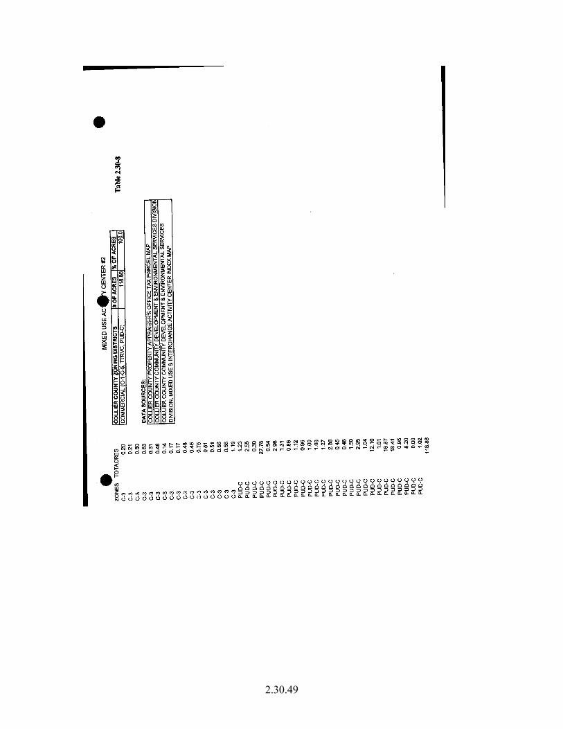
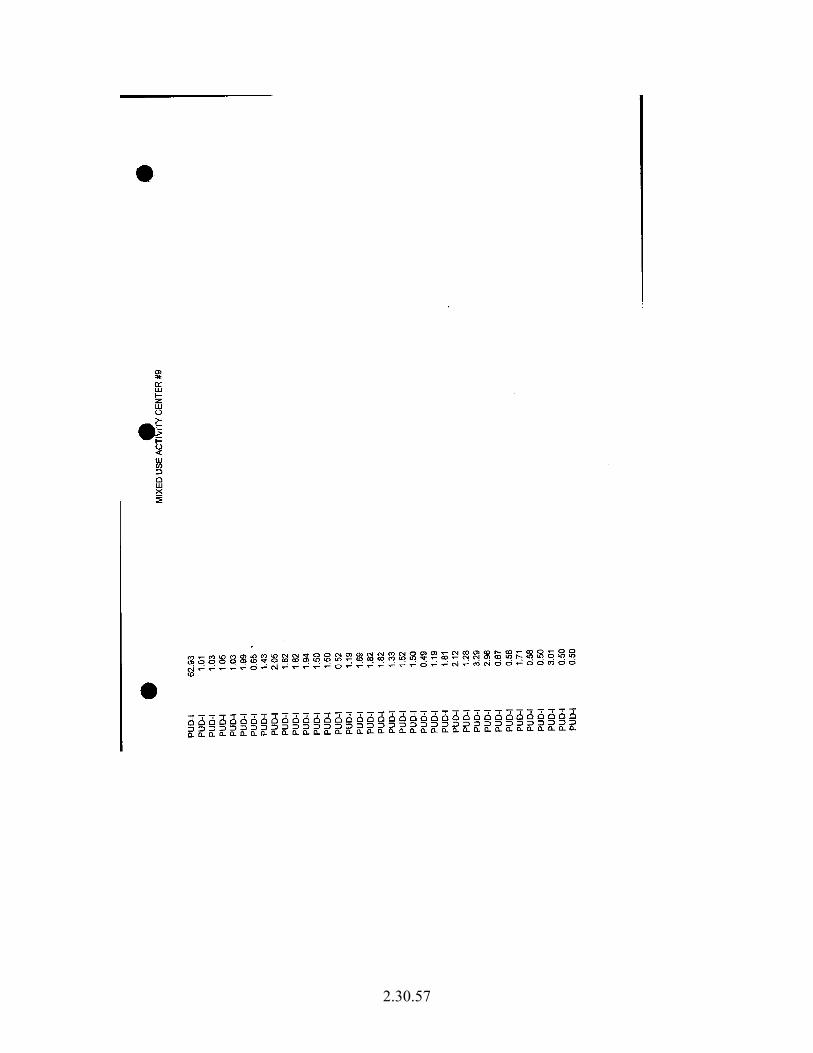
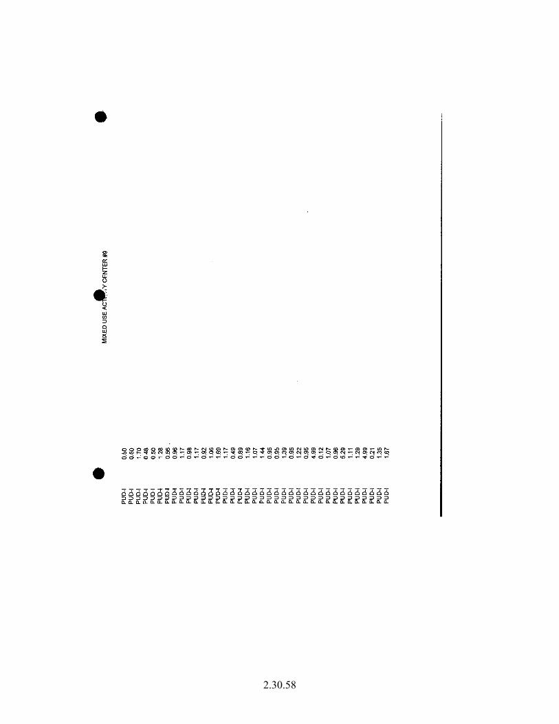
Using the Best Available Data from the Collier County Property Appraiser’s Office (PAO), the County’s Comprehensive Planning Department staff (Staff) analyzed and compared the PAO’s 2000 and 2004 tax parcel data sets for the type and amount of development that had occurred within both of these Activity Center Subdistricts in order to evaluate the extent to which they have achieved the desired results from the above referenced FLUE Objectives 5 and 6 and Transportation Element Objectives 2 and 5. Staff summarized the number of parcels and the number of acres per Land Use Code from the Florida Department of Revenue (FDOR), see Tables 2.30-1 and 2.30-1.1:
To put the above numbers into the proper perspective, staff reviewed all of the rezones that occurred from 1996 to 2004 within the Mixed Use Activity Centers and Interchange Activity Center Subdistricts. Over the past seven years, for every residential rezone approved, three commercial rezones were approved. Please refer to Table 2.30-2: Table 2.30-2 Zoning Changes Within Activity Centers, 1996-2004
Year ZONING CHANGES COUNT
1996 A→C4 1 1996 A→C5 1 1996 E→PUD-C 1 1996 I→C-4 1 1996 RMF-12→PUD-C 1 1997 C-2 & A→PUD-C 1 1997 CF→PUD-C 1 1997 E→C-1/T 1 1997 E→PUD-C 1 1997 RSF-4→C-1 1 1999 A→C-5 1 1999 RSF-3→C-2 1 2000 I→PUD-C 1 2001 A→C-5 1 2002 A→C-3 1 2003 A→PUD-R 2 2003 PUD-R→PUD-R 2 2003 RSF-1→PUD-R 1 2004 A→PUD-C 1 LEGEND: ZONING DISTRICTS A Rural Agricultural C-1 Commercial Professional C-1/T Commercial Professional Transitional C-2 Commercial Convenience C-3 Commercial Intermediate C-4 General Commercial C-5 Heavy Commercial CF Community Facility E Estates I Industrial PUD-C Planned Unit Development-CommercialPUD-R Planned Unit Development-ResidentialRSF-1 Residential Single Family-1 RSF-3 Residential Single Family-3 RSF-4 Residential Single Family-4 RMF-12 Residential Mulitple Family-12
2.30.13
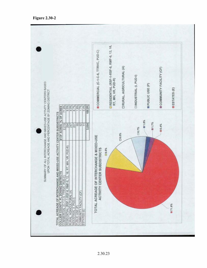
The Board of County Commissioners and Planning Commission directed staff to prepare an analysis that examined the current total acreage by zoning districts for both the Mixed Use and Interchange Activity Center Subdistricts. Please refer to Figure 2.30-1 for a complete summary of these findings. Additional supporting data and analyses are located at the end of this section. Figure 2.30-1: Total Acreage By Zoning Districts, April 2004 COLLIER COUNTY, FL ZONING DISTRICTS # OF ACRES % OF ACRESCOMMERCIAL (C-1-C-5, TTRVC, PUD-C) 2,219 71.8% RESIDENTIAL (RSF-1-RSF-6, RMF-6, 12, 16, RT, MH, VR, PUD-R) 294 9.5% RURAL, AGRICULTURAL (A) 247 8.0% INDUSTRIAL (I, PUD-I) 207 6.7% PUBLIC USE (P) 55 1.8% COMMUNITY FACILITY (CF) 59 1.9% ESTATES (E) 11 0.4% 3,091 100.0%
2.30.14
Urban Residential Fringe Subdistrict The purpose of this Subdistrict is to provide transitional densities between the Urban Designated Area and the Agricultural/Rural Area. Moreover, to ensure that the transitional semi-rural character of the Urban Residential Fringe Subdistrict is protected, the Residential land uses may be allowed at a maximum density of 1.5 units per gross acre. Using the Best Available Data from the Collier County Property Appraiser’s Office (PAO), the County’s Comprehensive Planning Department analyzed and compared the PAO’s 2000 and 2004 tax parcels for the type and amount of development that had occurred within Urban Residential Fringe Subdistrict in evaluation was achieved by a summary of the number of parcels and the number of acres per Land Use Code from the FDOR, see Table 2.30-3:
1 Vacant (Residential, Commercial, Industrial, or Institutional) Land – land without buildings. May or may not have improvements, such as grading, sewers, etc.
2 Vacant Unimproved (Residential) Lands – most commonly lands without buildings; it can also mean land in its natural state. 3 Improved (Residential, Commercial, Industrial, or Institutional) Land – land having onsite improvements, offsite improvements, or both
D. Objective Achievement Analysis Activity Center Subdistricts The following observations come from the analysis and comparison between the PAO’s 2000 and 2004 tax parcels for the type and amount of development that had occurred within the combined Mixed Use Activity Subdistrict and Interchange Activity Center Subdistrict: Vacant Residential
• Of the twelve different categories, land consisting of Vacant Residential acreage made up the largest component (24.9%) of the total acreage for 2000 and (17.9%) of the total acreage 2004.
• There was a 42.8% decrease in the amount of acreage that was classified Vacant
Residential from 2000 to 2004. Vacant Unimproved Residential
• Of the twelve different categories, land consisting of Vacant Unimproved Residential acreage made up the fifth largest component (9.2%) of the total acreage for 2000 and (7.0%) of the total acreage 2004.
There was a 34.9% decrease in the amount of acreage that was classified Vacant Unimproved Residential from 2000 to 2004. Improved Residential
• Of the twelve different categories, land consisting of Improved Residential acreage made up the fourth largest component (11.3%) of the total acreage for 2000 and (13.4%) of the total acreage 2004.
• There was a 13.7% increase in the amount of acreage that was classified
Improved Residential from 2000 to 2004. Agriculture
• Of the twelve different categories, land consisting of Agriculture made up the eighth largest component (4.2%) of the total acreage for 2000 and (1.7%) of the total acreage 2004.
• There was a 157.4% decrease in the amount of acreage that was classified
Agriculture from 2000 to 2004.
2.30.16
Government Lands
• Of the twelve different categories, land consisting of Government Lands made up the eighth largest component (4.2%) of the total acreage for 2000 and (1.7%) of the total acreage 2004.
• There was a 3.2% increase in the amount of acreage that was classified
Government Lands from 2000 to 2004. Easements
• Of the twelve different categories, land consisting of Easements made up the seventh largest component (5.1%) of the total acreage for 2000 and (5.4%) of the total acreage 2004.
• There was a 7.1% increase in the amount of acreage that was classified Easements
from 2000 to 2004. Vacant Commercial
• Of the twelve different categories, land consisting of Vacant Commercial made up the third largest component (13.5%) of the total acreage for 2000 and (17.9%) of the total acreage 2004.
• There was a 22.7% increase in the amount of acreage that was classified Vacant
Commercial from 2000 to 2004. Improved Commercial
• Of the twelve different categories, land consisting of Improved Commercial made up the second largest component (21.8%) of the total acreage for 2000 and (25.8%) of the total acreage 2004.
• There was a 13.3% increase in the amount of acreage that was classified
Improved Commercial from 2000 to 2004. Vacant Industrial
• Of the twelve different categories, land consisting of Vacant Industrial made up the eleventh largest component (0.5%) of the total acreage for 2000 and (0.9%) of the total acreage 2004.
• There was a 43.3% increase in the amount of acreage that was classified Vacant
Industrial from 2000 to 2004.
2.30.17
Improved industrial
• Of the twelve different categories, land consisting of Improved Industrial made up the smallest component (0.2%) of the total acreage for 2000 and (0.6%) of the total acreage 2004.
• There was a 65.7% increase in the amount of acreage that was classified
Improved Industrial from 2000 to 2004. Vacant Institutional
• Of the twelve different categories, land consisting of Vacant Institutional made up the tenth largest component (1.6%) of the total acreage for 2000 and (0.9%) of the total acreage 2004.
• There was a 87.8% decrease in the amount of acreage that was classified Vacant
Institutional from 2000 to 2004. Improved Institutional
• Of the twelve different categories, land consisting of Improved Institutional made up the ninth largest component (2.5%) of the total acreage for 2000 and (3.1%) of the total acreage 2004.
• There was a 16.2% increase in the amount of acreage that was classified
Improved Institutional from 2000 to 2004. In the 1996 EAR, it was acknowledged that Activity Center concept was a failure. The intent of Activity Centers were to: establish mixed use developments that would create centers of activity and a sense of place with residential, civic, cultural and recreational opportunities in addition to commercial opportunities to meet the needs of the residents within and adjacent to the Activity Center as well as pass-by traffic; provide employment opportunities for residents within and adjacent to the Activity Center; avoid strip commercial development, and; concentrate most new commercial development where traffic impacts could be readily accommodated. As envisioned in the 1989 Growth Management Plan, Activity Centers varied in size, varied in use intensity and contained a cap on the amount of each Activity Center that could be zoned for commercial development. However, when adopted, almost all of the 21 Activity Centers were of the same size – ½ mile square, 40 acres per quadrant; all of them allowed the full array of commercial uses – C-1 through C-5 zoning; and, the commercial cap was removed thereby creating the potential for 100% of each Activity Center to be zoned commercial. Along with these changes, “factors to be considered” during review of rezone petitions was added. Those factors were too broad and/or vague such that it made it very difficult not to approve the requests to rezone to commercial. From adoption in 1989 to present, almost all rezone petitions have been for commercial uses; just a few have been for mixed use projects and none of the residential components have yet been developed. The
2.30.18
largest residential components within mixed-use projects lie in Interchange Activity Center #9 at I-75/Collier Blvd. (CR-951); these are most likely due to the cap on commercial development at no more than 55% of the Activity Center acreage. That cap was imposed as part of the 1997 EAR-based amendments, which coincided with doubling the size of that Activity Center (from +/- 300 acres to 632 acres). A few activity centers do contain developed residential uses but those pre-dated the establishment of Activity Centers, i.e. were approved under a previous comprehensive plan. The primary response to this acknowledged failure was to re-draw the boundaries of the Mixed Use Activity Centers to be site specific and, for the most part, to follow existing commercial zoning boundaries thereby reducing the potential for future commercial rezones in the Activity Centers. Notably, the two Activity Centers with the least amount of commercial zoning at that time - #3 at Immokalee Road/Collier Blvd. and #7 at Rattlesnake-Hammock Road/Collier Blvd. - were left in the ½ mile square configuration (40 acres per quadrant). The rationale was that there was still significant residential development yet to occur in the surrounding areas and there would be a need for commercial uses to serve that development. Also, in the case of Activity Center #3, it was considered that residential development east of the urban area (portions of the Rural Fringe area and portions of northern Golden Gate Estates) would need to be served by commercial uses that could be located in that Activity Center. A significant amount of commercial development within Activity Centers consists of community shopping centers anchored by a supermarket, big box retail stores (e.g. Sports Authority, Walmart, Home Depot), or both – a community shopping center with one or more big box retail stores (e.g. Pine Ridge Crossings shopping center with a Publix supermarket and Target store). Regardless of the type of commercial development, it serves as a traffic attractor – people drive to the Activity Center to shop, dine, use personal services, visit an office, etc. In most cases, heavy traffic volumes already exist on the two arterial (or arterial and collector) roads around which the Activity Centers are located. On the one hand, arterial roads are designed for heavy traffic volumes by their very nature. But on the other hand, the heavy traffic volumes in the coastal urban area are due in part to the limited number of north-south and east-west roadways; the lack of a grid street pattern in most of the coastal urban area; the lack of project interconnections - whether between adjoining residential developments, adjoining commercial developments, or adjoining residential and commercial developments – which forces traffic onto external roadways, frequently arterial and collector roads; the lack of mixed use developments which forces all patrons of commercial establishments to travel away from the development in which they live; and, the lack of complete and integrated bicycle or pedestrian pathway systems and extensive mass transit system to offer viable transportation alternatives. The combination of heavy traffic volumes already traveling through the Activity Center intersections, and the major commercial developments located there that draw traffic to the intersection, has resulted in heavily congested intersections, some of which experience significant traffic back-ups. Some rank high on the list of rankings of traffic
2.30.19
accident sites, and many are expected to be future candidates for grade separated intersections (based upon traffic volumes approaching 100,000 trips per day.) Intersection congestion is even less desirable/acceptable when it involves I-75. One major difference at these intersections is the access control onto the roadways – no ingress/egress is allowed on I-75, and a certain distance from the interstate along the County road is also under FDOT jurisdiction in which no, or very limited, ingress/egress is allowed. Given the purpose of the interstate is primarily for the traveling public (relatively long trips), not for local use (relatively short trips), it seems logical to allow, in those Interchanges where commercial development is allowed, commercial uses to serve the traveling public, such as gas stations, restaurants and hotels/motels; also, uses that may be dependent upon the interstate highway system, such as certain warehousing, manufacturing, and distribution facilities. These were the only types of uses allowed under the 1983 comprehensive plan. One must now question the appropriateness of allowing big box retail stores and community shopping center uses at Interchange Activity Centers. For these reasons, the County may recommend a change in the type of commercial uses allowed at Interchange Activity Centers. However, the County also acknowledges that most of the lands within these Interchange Activity Centers have already been rezoned to commercial, and that most of this commercial zoning allows community shopping centers and/or big box retail uses. Accordingly, the zoning on these properties would need to be changed (amend the commercial PUDs to preclude certain uses and/or limit the building square feet for certain uses and similarly amend the commercial zoning districts in the LDC for properties lying within Interchange Activity Centers). There may be legal ramifications for zoning changes imposed by the County. Therefore, the ability to amend the Interchange Activity Center Subdistrict to limit the allowable uses may be limited. Urban Residential Fringe Subdistrict Reasons for the current Increase in the Residential Density within the Urban Residential Fringe Subdistrict (URF):
• Two changes have occurred to this subdistrict since the 1996 EAR: 1) the ability to increase density from 1.5 dwelling units per acre (DU/A) to 2.5 DU/A through the County’s Transfer of Development Rights program, as part of the Rural Fringe GMP amendments adopted in 2002; and, 2) the ability to increase density from 1.5 DU/A to 6 DU/A for affordable housing for a particular parcel via a private sector amendment approved in 2003.
• Net residential densities may be significantly higher than 1.5 DU/A in PUDs
where wetlands and golf courses factor into gross densities. • Various non-residential uses act as attractors in the Urban Residential Fringe,
including: 1) First Assembly of God Planned Urban Development (PUD) –campus approved for church, homeless shelter, etc.; 2) swamp buggy grounds –
2.30.20
races, shooting range, etc.; and, 3) commercial uses in Activity Center #7 on the east side of Collier Boulevard.
Reasons for the potential increase in commercial density within the URF:
• The pending rezone to establish the Collier Regional Medical Center PUD - partly in Mixed Use Activity Center #7 but mostly within the Urban Residential Fringe - for hospital and medical offices. If approved, additional lands within ¼ mile of the hospital site will be eligible for medical office uses. (For comparison, there are several medical office PUDs approved along Immokalee Rd. within ¼ mile of the North Collier Hospital – this might be an indicator of what may occur near this hospital site.)
• Growth Management Plan Amendment CP-2002-1 was approved last year
thereby expanding the northeast quadrant of the mixed use activity center located at the intersection of Collier Boulevard (CR-951) and Sports Park Road (Activity Center #7) by approximately 18.5 acres. In that expansion area, uses will be limited to personal self-storage facilities, office and warehouse space associated with specialty contractors.
Vacant Residential
• Of the twelve different categories, land consisting of Vacant Residential acreage made up the fifth largest component (8.6%) of the total acreage for 2000 and (2.3%) of the total acreage 2004.
• There was a -297.9% decrease in the amount of acreage that was classified Vacant
Residential from 2000 to 2004. Vacant Unimproved Residential
• Of the twelve different categories, land consisting of Vacant Unimproved Residential acreage made up the fifth largest component (22.2%) of the total acreage for 2000 and (23.2%) of the total acreage 2004.
There was a -0.9% decrease in the amount of acreage that was classified Vacant Unimproved Residential from 2000 to 2004. Improved Residential
• Of the twelve different categories, land consisting of Improved Residential acreage made up the third largest component (17.3%) of the total acreage for 2000 and (19.6%) of the total acreage 2004.
• There was a 6.9% increase in the amount of acreage that was classified Improved
Residential from 2000 to 2004.
2.30.21
Agriculture
• Of the twelve different categories, land consisting of Agriculture made up the largest component (42.6%) of the total acreage for 2000 and (45.2%) of the total acreage 2004.
• There was a 0.3% increase in the amount of acreage that was classified
Agriculture from 2000 to 2004. Government Lands
• Of the twelve different categories, land consisting of Government Lands made up the sixth largest component (1.6%) of the total acreage for 2000 and (1.7%) of the total acreage 2004.
• There was no increase in the amount of acreage that was classified Government
Lands from 2000 to 2004. Improved Commercial
• Of the twelve different categories, land consisting of Improved Commercial made up the ninth largest component (0.2%) of the total acreage for 2000 and (0.3%) of the total acreage 2004.
• There was a 12.7% increase in the amount of acreage that was classified
Improved Commercial from 2000 to 2004. Improved Industrial
• Of the twelve different categories, land consisting of Improved Industrial made up the fifth largest component (0.2%) of the total acreage for 2000 and (0.6%) of the total acreage 2004.
• There was no increase in the amount of acreage that was classified Improved
Industrial from 2000 to 2004. Vacant Institutional
• Of the twelve different categories, land consisting of Vacant Institutional made up the seventh largest component (1.4%) of the total acreage for 2000 and (1.4%) of the total acreage 2004.
• There was a -10.8% decrease in the amount of acreage that was classified Vacant
Institutional from 2000 to 2004.
2.30.22
Improved Institutional
• Of the twelve different categories, land consisting of Improved Institutional made up the eighth largest component (1.1%) of the total acreage for 2000 and (1.1%) of the total acreage 2004.
• There was no increase in the amount of acreage that was classified Improved
Institutional from 2000 to 2004. E. Conclusion Mixed Use Activity Centers Commercially zoned land within the Mixed Use Activity Center and Interchange Activity Center Subdistricts continues to be the dominant land use category as most properties are rezoned to a commercial zoning district and develop with commercial land uses. The main goal of these two activity center subdistricts is to concentrate all new commercial development within carefully configured access points to the main arterial roadway network. However, this goal has been somewhat unsuccessful, and there continues to be commercial development in isolated pockets emanating outside of these activity center subdistricts. The reason for the lack of success is the majority of commercially zoned lands lie outside of activity centers. Some of these lands are consistent with other commercial locational criteria in the FLUE. However, most of these lands were zoned commercial at the time of the FLUE adoption in 1989 and were subsequently evaluated under the County’s zoning re-evaluation program pursuant to former policy 3.1k and were allowed to retain their commercial zoning. These properties are identified on the Consistent By Policy Maps, part of the Future Land Use Map series, and are recognized in FLUE Policies 5.9 – 5.12. Also, some of these lands were rezoned to commercial based upon the former activity center boundaries, and are recognized in FLUE Policy 5.13. Urban Residential Fringe Subdistrict Based upon the data and analysis, the County concludes that the integrity of this Subdistrict to provide transitional densities between the Urban Designated Area and the Agricultural/Rural Area has been maintained. The underlying objectives of this subdistrict have been achieved in regards to preventing urban sprawl.