45
Character Area Analysis Chapter 5 56 ST AGNES CONSERVATION AREA APPRAISAL Consultation Draft MAY 2008 24.0 Vicarage Road

Character Area Analysis Chapter 5
56
ST AGNES CONSERVATION AREA APPRAISAL C o n s u l t a t i o n D r a f tMAY 2008
24.0 Vicarage Road
57
ST AGNES CONSERVATION AREA APPRAISAL C o n s u l t a t i o n D r a f t MAY 2008
Character Area Analysis Chapter 5
24.1 Vicarage Road Character Summary
Vicarage Road is one of the main routes into the
heart of St Agnes village. Vicarage was formerly
a small hamlet now attached to Churchtown. The
properties within the conservation area that are
either side of the road are predominantly 2 storey,
mostly in residential use with some commercial
properties including public houses, bank, shops and
café/restaurants.
Being the most direct route from Truro to St Agnes
from the south of the village, Vicarage Road has
an ‘important historic character of trade’, which is
clearly supported by the nature of development
along it.
The road is relatively level until it reaches the
gentle bend into Churchtown where it begins to run
downwards (eventually to Peterville at the bottom of
the valley).
At its southern end, it starts where the roads
converge from Truro to the south and Chapel Porth
to the west. Here the buildings either front directly
onto the street (back edge of the pavement) or
have small front gardens with local stone of brick
boundary walls. The boundary walls and buildings
help to enclose the space and inform this section
of the street. The character is further deepened by
the richness in architectural detail, No‘s 65 and 66
are a pair of semi-detached Victorian villas whose
red brick facades add colour and warmth to the
conservation area. Opposite at no. 2 is a more
traditional town cottage (circa mid 19th century)
in the local stone killas with dressings and central
front doorway – now offset by late 19th century
extension. Along with the dwelling the low dressed
stone front boundary wall, round headed gate plus
20th century iron railings are all Grade II listed.
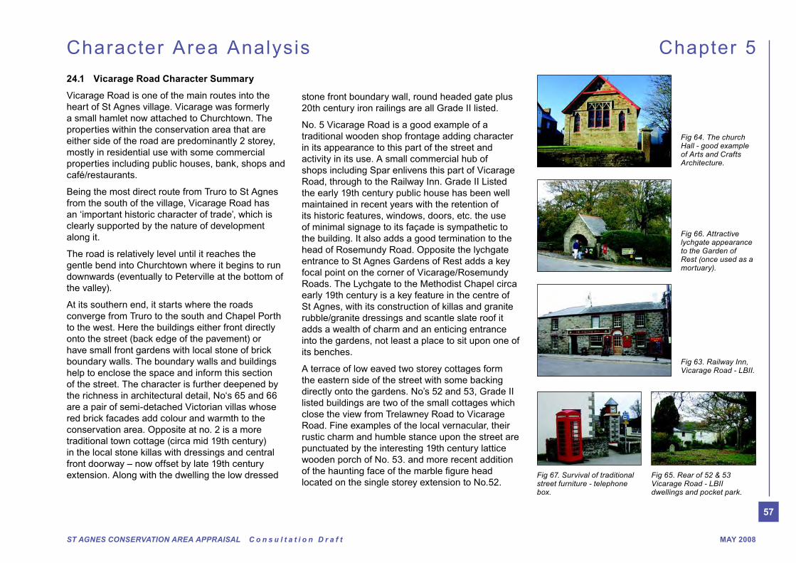
No. 5 Vicarage Road is a good example of a
traditional wooden shop frontage adding character
in its appearance to this part of the street and
activity in its use. A small commercial hub of
shops including Spar enlivens this part of Vicarage
Road, through to the Railway Inn. Grade II Listed
the early 19th century public house has been well
maintained in recent years with the retention of
its historic features, windows, doors, etc. the use
of minimal signage to its façade is sympathetic to
the building. It also adds a good termination to the
head of Rosemundy Road. Opposite the lychgate
entrance to St Agnes Gardens of Rest adds a key
focal point on the corner of Vicarage/Rosemundy
Roads. The Lychgate to the Methodist Chapel circa
early 19th century is a key feature in the centre of
St Agnes, with its construction of killas and granite
rubble/granite dressings and scantle slate roof it
adds a wealth of charm and an enticing entrance
into the gardens, not least a place to sit upon one of
its benches.
A terrace of low eaved two storey cottages form
the eastern side of the street with some backing
directly onto the gardens. No’s 52 and 53, Grade II
listed buildings are two of the small cottages which
close the view from Trelawney Road to Vicarage
Road. Fine examples of the local vernacular, their
rustic charm and humble stance upon the street are
punctuated by the interesting 19th century lattice
wooden porch of No. 53. and more recent addition
located on the single storey extension to No.52.
Fig 64. The church Hall - good example of Arts and Crafts Architecture.
Fig 65. Rear of 52 & 53 Vicarage Road - LBII dwellings and pocket park.
Fig 66. Attractive lychgate appearance to the Garden of Rest (once used as a mortuary).
Fig 67. Survival of traditional street furniture - telephone box.
Fig 63. Railway Inn, Vicarage Road - LBII.
58
ST AGNES CONSERVATION AREA APPRAISAL C o n s u l t a t i o n D r a f tMAY 2008
Character Area Analysis Chapter 5
premises on the east. No 41 and 41A Vicarage
Road (corner of Pengarth Road) are good examples
of a mid 19th century corner shop with living
accommodation over, and 19th century shop fronts
with original details of 3 light and 4 light frontages.
Set back slightly from the road is the former
chapel now St Agnes Meadery. Basically, a good
building with extremely unfortunate alterations to
the front, including the turret and porch, vent duct,
replacement with wide concrete apron to access/
pull on. Due to its prominent location this building
the conservation area rather than detract from it.
Flanking both sides of the northern part of Vicarage
Road, gracefully forming the bend in the road are
the historic terraces with their architectural detailing
and enclosed areas. No’s 32, 33 and 34 (terraced)
Victorian dwelling houses have retained many of
their original architectural details – sash windows,
6 panel doors and stone front boundary walls with
moulded stone copings. But alas most have lost the
iron railings from ‘atop’ the walls as donations to the
war effort, appropriate replacements would help to
nature of this row of elegant dwellings.
No. 37 has some notable classical details Victorian
scroll, platt band and key stones (giant end) and
window additions and rough render are regrettably
unsympathetic. No’s 39 and no. 40 (Sally’s Bistro)
have also been altered greatly with unsightly ground
On the northern corner of Trelawney Road, the ‘new
clock tower’ and red telephone kiosk are interesting
features backed by the Parish Rooms, whilst
unlisted this building adds a positive contribution to
the character and appearance of the conservation
area.
The former Miners and Mechanics Institute (Listed
Buildig) now used as meeting rooms and a ‘private’
members’ bar marks the transition in the street to
a more formal building layout. This strong building
along with stone front boundary walls with intricate
Edwards building. It is heartening to note that the
original detailing has been retained and maintained
well over the years. In particular the matching iron
railing and front gate which unlike others missed the
pillaging of war years (for the war effort).
It is unfortunate that the ‘sense of enclosure’ here
is missing. This is due to the loss of the front
boundary walls to no19 and no 20 for hardstanding.
No.19 shows the tell tale signs of its former use
with its adapted shop front window while No.21
has some unfortunate window replacements, no
20 is good with its original door and sash windows
and iron gate. With some alterations – sympathetic
window replacements, planting and reintroduction
of appropriate front boundary treatment this small
group could be much improved and create an
attractive feature when viewed along British Road/
Vicarage Road.
From the corner of British Road the street begins to
‘Georgian style’ town houses on the west side and
a mix of 19th century dwellings and commercial
additions, mismatched materials and loss of front
boundary, respectively, all detracting from the
character and appearance of the conservation area.
The Victorian villas, west side of Vicarage Road
help to create a terraced effect due to their
location on higher ground. Although set back
further from the road than the dwellings opposite
they are prominent within the street scene due to
their height and formal layout which deliver the
‘inside of the bend’. Glanville Terrace – No’s 28
– 31 have sustained many ‘modern’ additions and
alterations, including upvc windows and heavy
painting. However, the retention of the stone
boundary wall here helps to uniform this group of
houses, highlighting the importance of this means of
enclosure and the need for future resistance to loss
of the boundary walls to make way for car parking.
North of this group is the grade II listed church
hall. Built in the Arts and Crafts style this late 19th
century building with its red painted projected
eaves and verges affords interest to the passer-by.
Unfortunate, recent alterations to widen the access;
raise the level of the paving, loss of nice moulded
stone cappings and removal of railings depletes
the quality of this part of the street scene, simple
changes here could greatly improve the immediate

59
ST AGNES CONSERVATION AREA APPRAISAL C o n s u l t a t i o n D r a f t MAY 2008
Character Area Analysis Chapter 5
24.2 Vicarage Road General Description
Activity & Uses
into the heart of St Agnes village. Formerly
a small hamlet now attached to Churchtown
–predominantly residential but some commercial
properties -cafes/restaurants, community
buildings, including Doctors surgery and club
Townscape/Morphology
fronting onto Vicarage Road - many with small
front gardens bounded by stone walls some with
railings - others back edge of pavement
terraced. However, at the rear of the properties
(west of Vicarage Road) more modern estate
type dwellings exist outside the conservation
area boundary
Trees, landscape, spaces & gardens
planting help to soften the stone facades of
the buildings - St Agnes Garden of Rest , well
maintained and very good example of ‘pocket
park’ within village well treed, positive addition to
character and appearance of the conservation
area and great amenity value
Views and vistas
some towards the open countryside and Wheal
Kitty area to the east at the top of British and
Rosemundy roads
Focal Points
Miners & Mechanics Institute, entrance into St
Noise levels (ambient character)
some noise from commercial properties, but
generally quiet area
Building type/architectural style
rendered, painted facades whilst others local
stone
Listed Buildings
information in the appendix for details of all listed
buildings. Some of the most notable buildings
here are: Miners & Mechanics Institute LBII, 32-
34 Vicarage Rd terrace of dwellings LBII, Church
Hall LBII and 5 Vicarage Road - shop
Unlisted buildings - of interest/townscape merit
26-31 Vicarage Road - dwellings.
Schedule Ancient Monuments
Unique/unusual features
properties
Overall quality of built and natural environment
appearance and character. However, highway
interventions including street furniture (e.g.
lamps) and loss of front boundary walls due to
pressure for parking, and inappropriate additions
to facades of buildings are negative in terms of
their impact upon the character and appearance
of the conservation area..
Positive features
terraced dwellings - some with original boundary
walls and gate piers, retention of key features
- wooden windows and doors
activity through the day and some of the night,
i.e. residential and cafes/restaurants
dwellings and small cottage style residences
mostly characterised by small front gardens
or properties abutting the back edge of the
pavement
- great local amenity space
atmosphere
60
ST AGNES CONSERVATION AREA APPRAISAL C o n s u l t a t i o n D r a f tMAY 2008
Character Area Analysis Chapter 5
Pressure
Negative features
highway— inappropriate forms of signage i.e.
street names on plastic rather than metal signs
and other buildings to create access and car
parking - negative effect upon the character
and appearance of the conservation area and
streetscene in general— loss of formal enclosure
façade to Meadery building
boundary walls lost to widen road over time
- proliferation of street markings, roundabout etc
plain bollards
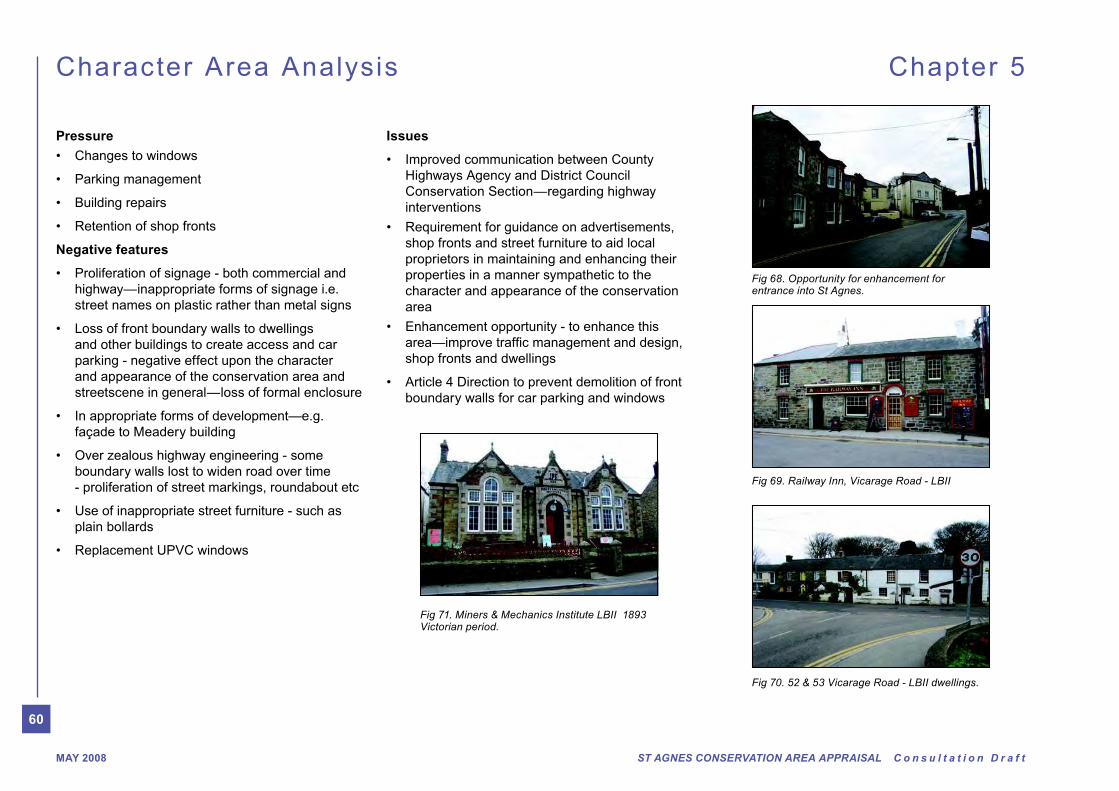
Fig 69. Railway Inn, Vicarage Road - LBII
Fig 70. 52 & 53 Vicarage Road - LBII dwellings.
Fig 71. Miners & Mechanics Institute LBII 1893 Victorian period.
Fig 68. Opportunity for enhancement for entrance into St Agnes.
Issues
Highways Agency and District Council
Conservation Section— regarding highway
interventions
shop fronts and street furniture to aid local
proprietors in maintaining and enhancing their
properties in a manner sympathetic to the
character and appearance of the conservation
area
shop fronts and dwellings
boundary walls for car parking and windows
61
ST AGNES CONSERVATION AREA APPRAISAL C o n s u l t a t i o n D r a f t MAY 2008
Character Area Analysis Chapter 5
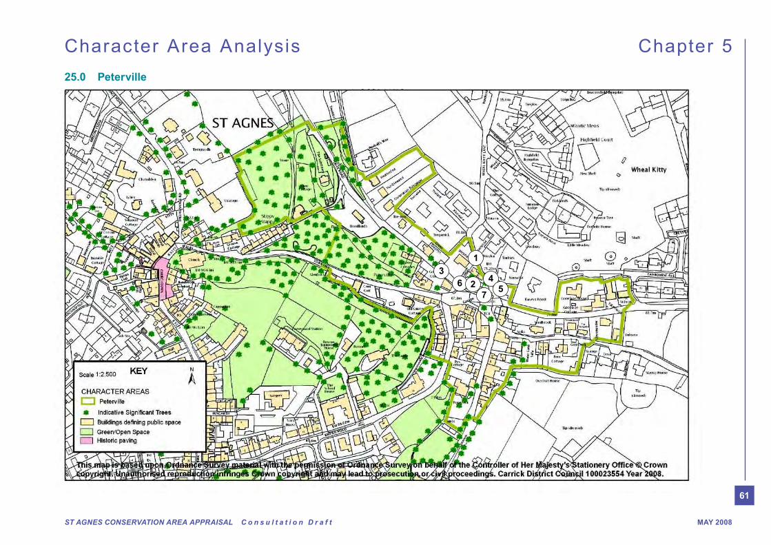
25.0 Peterville
34
56 2
7
1
62
ST AGNES CONSERVATION AREA APPRAISAL C o n s u l t a t i o n D r a f tMAY 2008
Character Area Analysis Chapter 5
25.1 Peterville Character Summary
Peterville was formerly a hamlet in its own right
located in a little valley that runs along Trevaunance
Coombe, eventually leading to the sea at
Trevaunance Cove. The main area is a former
square with terraced houses, shops and Peterville
Inn fronting directly onto the road. Until the late
19th century Peterville was known as ‘Dirtypool’.
This amusing name was thought to originate from
the fact that there was a large pool of water in the
square. Apparently, according to local historians
this was water from the stream in Water Lane which
times. It was eventually colverted and re-emerges
behind Peterville Inn, through the woodland to the
sea.
Most of the buildings are two-storey domestic in
scale. The most notable buildings being no’s 12 and
13 fronting onto the square which are grade II listed.
Formerly one house, at some time it was converted
into two houses. Built around the mid 19th century
the houses are coursed killas walls with dressed
granite quoins and dressed arches over openings.
This building acts as a centre piece backdrop to the
open area of the square.
No’s 1-7 Peterville, which include the Tap House
wine bar, surf shop and dwellings form the northern
perimeter of the square. Although there have been
recent additions to the foreground of the Tap House,
the rest of the group appear to be maintained in
good order. Other buildings of note include the
Peterville Inn, located at the bottom of Town Hill, the
three small cottages opposite at no’s 14-16 and no’s
8 and 9 Peterville located on the west side of the
square.
The square as a whole and in particular the area
outside the Tap House is probably the most hostile
pedestrian environment in the whole of the village.
Although the square has always been a large open
junction at Vicarage Road, British Road and Town
Hill makes it dangerous to pedestrians due to the
fast moving vehicles. Large buses and lorries have
also caused slight damage to the front boundary
walls of some of the properties along British Road,
as they negotiate their way round the bend and up
the hill. This area needs a bespoke enhancement
scheme to create a greater/better ‘sense of place’
25.2 Quay Road
Quay Road runs through Trevaunance Coombe,
with the woods on the left hand side and small
cottages on the right to Trevaunance Cove. The
conservation area is proposed to be extended
in this area along the backs of properties on the
northern edge of Peterville and along Quay Road.
This is to include some traditional buildings, and
small plots enclosed by Cornish hedges.
25.3 Town Hill
Town Hill runs from St Agnes Church and
Churchtown at the top of the hill and enters
Peterville by the Peterville Inn. Flanked on its
southern side by the hill rising up and over to
the Coastguard Cottages and the woodland of
Trevaunance Coombe along its northern edge, the
road runs straight into the heart of Peterville. Given
its location on the side of the hill, a walk along this
views towards the sea at Trevaunance Coombe
across the tree tops.
Glenbuck, Carn Cottage and Old Quarry Cottage,
are all built into the side of the hill taking advantage
of the views towards the sea, these properties are
unique in their elevated locations.
25.4 British Road
At the southern end of British Road where it
buildings in the streetscape and good examples of
Victorian Villas. The stone front boundary walls help
between public and privately owned space.
Opposite, small two storey traditional granite/killas
stone cottages front directly onto the road adding
quaint interest to this part of the street.

63
ST AGNES CONSERVATION AREA APPRAISAL C o n s u l t a t i o n D r a f t MAY 2008
Character Area Analysis Chapter 5
25.5 Rosemundy
Rosemundy is generally a quiet lane, less used
than the other routes into and out of Peterville. This
road has been heavily engineered, being half-way
up a steep embankment. This has led to a large
over-grown bank on its east side , looking into the
now green valley, giving the whole an air of rural
seclusion.
At its north eastern end where it enters/exits
Peterville, the mature tree canopy opens to reveal
a tight knit townscape which creates a great sense
of arrival, with the village shop being an active focal
point.
The terrace of small cottages on the western side
of the lane date back to the early 19th century with
the earlier, former Malt House building (opposite the
present shop) framing the bended entrance of the
road (with its boundary wall) into Peterville ‘square’.
The later buildings, late 19th century and early
20th century abut the east side of the road. It is
heartening to see the retention of the former corn
store double wooden doors, which add a sense of
former identity to this building and interest to the
street.
25.6 Goonlaze
Otherwise known as the B3285, St Agnes to
Perranporth Road, Goonlaze Road joins Peterville
at its eastern edge. The conservation area is
proposed to be extended here to include the
cottages on the north side of Goonlaze House
and Goonlaze Cottage, two granite/killas stone
dwellings with the latter abutting the road. These
buildings are worthy of townscape merit due to their
architectural detail and form. To the south of
the road are the rear boundaries of several
small plots accommodating a combination of
traditional cottages and bungalows, fronting
onto Water Lane.
25.7 Water Lane
Is a small lane that adjoins Rosemundy, it
is characterised by the leat that runs along
the side of the lane (the sinks) and the small
cottages which line the lane on both sides. This
is a delightful narrow lane, with its dwellings
and the constant sound of the trickle of water in
the leat.
25.8 Wheal Kitty Lane
Wheal Kitty Lane starts outside of Goonlaze
leading to Trevallas Porth. Immediately behind
the small cluster of cottages that front onto
Peterville the plots become larger and the
dwellings are predominantly bungalow form. An
extension to the conservation area is proposed
to include those dwellings that front onto Quay
Road and to the southern boundary of the
bungalows to include this part of Wheal Kitty
Lane, and Goonlaze Road. Due to its elevation,
across Peterville towards the Castle and Town
Hill with the heavy impressive tree cover; and
towards the jumble of roofscape of Churchtown
and Stippy Stappy.
Fig 72. 1 1-7 Peterville Square - terrace helps to delineate boundary of square
Fig 78. 7 Local street furniture could be updated
Fig 74. 3 Proliferation of signage
Fig 76. 5 Pair of attractive houses - 8 & 9 Peterville Square
Fig 73. 2 Listed Buildings - 12 & 13 Peterville Square
Fig 75. 4 Road dominated
Fig 77. 6 Ugly building - enhancement opportunity?
64
ST AGNES CONSERVATION AREA APPRAISAL C o n s u l t a t i o n D r a f tMAY 2008
Character Area Analysis Chapter 5
boundary walls to some properties
more intimate feel
Negative features
highway
predominantly bland tarmac landscape
conducive to this rural village location
style and design i.e. lamp standards, railings
location
garage
Issues
upon this part of St Agnes conservation area due to ‘road domination’, lack of planting and appealing pavement surface.
system and create more opportunity for green landscaping
property owners
25.9 Peterville General Description
Activity & Uses
nestled in the valley below Churchtown—formerly a small hamlet
Townscape/Morphology
‘square’ area. However, due to the large ‘open area’ dominated by the road, it feels a farther loose space
terraced, whilst at the rear of the Wine Bar, newer developments on large segregated plots are the norm
Trees, landscape, spaces & gardens
environment, other than small garden areas to the front of dwellings on the southern side of the ‘square’, other gardens in the area and the trees and greenery along the ridge behind northern buildings i.e. below Wheal Kitty
Views and vistas
of buildings along British Road towards Churchtown and the main body of the settlement
contribution to Peterville and the entrance to Peterville from the Perranporth road.
Focal Points
northern side of the square
Noise levels (ambient character)
residents complained of high noise levels, especially in the summer due to ‘drinkers’
outside the public houses in this area. However, in the winter months during the day, the area seemed rather quiet
Building type/architectural style
rendered, painted facades whilst others local stone
Listed Buildings
information in the appendix for details of all listed buildings. Some of the most notable buildings here are: 12 & 13 Peterville Square - houses LBII,
Unlisted buildings - of interest/townscape merit
Peterville Square, and the former Smithy at 14 Peterville Square
Schedule Ancient Monuments
Overall quality of built and natural environment
of appearance and character. However, the proliferation of signage and highway interventions including street furniture (e.g. lamps) are negative in terms of their impact upon the character and appearance of the conservation area. In effect the former square now resembles a wide road dominated ‘dead’ space.
Positive features
materials i.e. rendered or stone facades, wooden windows and doors
65
ST AGNES CONSERVATION AREA APPRAISAL C o n s u l t a t i o n D r a f t MAY 2008
Character Area Analysis Chapter 5
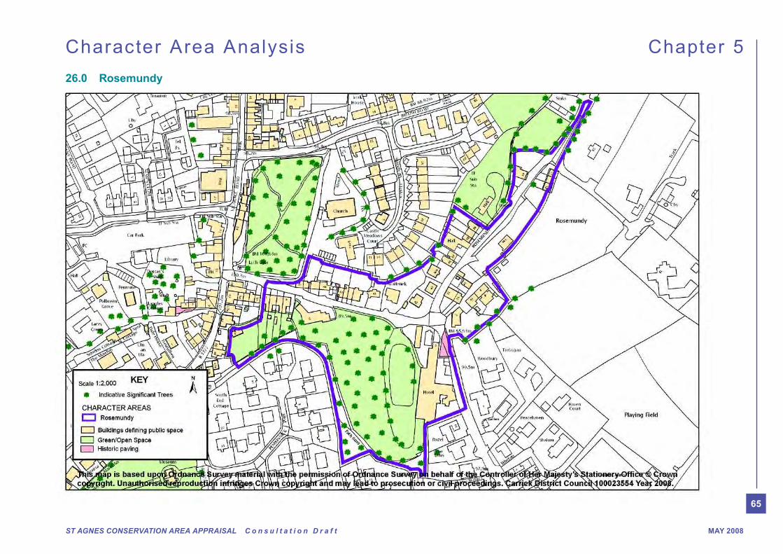
26.0 Rosemundy

66
ST AGNES CONSERVATION AREA APPRAISAL C o n s u l t a t i o n D r a f tMAY 2008
Character Area Analysis Chapter 5
26.1 Rosemundy Character Summary
A two way road which links Rosemundy to Vicarage
Road, Rosemundy Road accommodates mainly
residential properties, two storey domestic scale
dwellings and the former Rosemundy House, now
Hotel is one of the most prominent buildings set
within its large grounds.
The townscape here is a mix of Victorian terraced
dwelling and large villas. For the most part the
dwellings are early to late 19th century except
numbers 43, 44 – 47 Rosemundy, a row of
cottages, and Rosemundy Cottage which are 19th
century. The diversity here and excellent quality
provides a wealth of detail and character to this
area.
The prevalent and traditional building materials
here are a fusion of local granite killas, red and buff
coloured brickwork, natural slate roofs, wooden
fenestration, granite steps and boundary walls.
cobbled paving still exists.
The topography lends itself to providing good
views towards the open countryside from the top of
Rosemundy Hill, whilst the grounds of Rosemundy
Hotel create a wooded, countryside feel to this part
of the conservation area.
Victorian terrace on its southern side which borders
the woodland area to Rosemundy Hotel. This is a
well maintained group of buildings which retain a
good proportion of original features. Its strong form
front of the dwellings. The terrace here highlights
the depth of road engineering undertaken to form
Rosemundy Hill Lane.
For the rest of the lane the dwellings are local
vernacular cottages all with their own unique
character.
Some of the most noticeable buildings are the
row of 4 cottages no’s 44-47. These are late 18th
century and early 19th century and add historical
richness with their faced killas rubble facades
and 12 pane sash windows. This group has been
well maintained and retain many original features
including boundary walls and cobbled paving to the
front of the properties and the side alleyway.
At the bottom of the hill the cottages become more
humble with low eaves, irregular window opening
frontages all adding to their charm. 11,12 and 14
Rosemundy cottages to the eastern side of the
lane form a tight courtyard group of cottages,
with cobble stones and an oriel window as key
features. This group adds a real sense of organic
development to this part of the conservation area.
Terminating the view at the bottom of Rosemundy Hill are large Victorian villas that add character with their interesting wooden additions - one a corner bay the other a small lean-to orangery. Without doubt Rosemundy Hotel and its grounds are the largest most dominant building within this area. Probably 18th century remodelled in the 19th century and greatly extended in the 20th century
delabole slate roof sits grandly within its relatively large grounds much of which is mature woodland. The grounds of Rosemundy Hotel provide a large green area and backdrop to the village and is an important treed space.
The richness in architectural styles here from formal dwellings to small cottages (mostly characterised by
small front gardens with stone front boundary walls or back edge of the pavement), creates a cohesive townscape full of character and charm.
The importance of roofscapes is well expressed within the townscape, accentuated by a change in topography, coverings, chimneys and articulation. The roofs step down the sides of the valley. This undulating townscape form key views into the heart of the village.
Some negative features include pressure for on
pedestrians use as no pavement exists. The yellow lines and utilitarian street furniture detract from the intricate nature of this place.
The Mason’s lodge – formerly a Methodist chapel has been deprived of its outlook and connection
at risk. This building could be greatly improved by the insertion of appropriate windows and external refurbishment. As it stands it creates a negative impact upon the locality.
Recommendations for this area are to improve
pavement where appropriate and suitable street furniture. An article 4 direction would also be of
for car parking and replacement of traditional/original windows and doors with upvc, and
chimneys.
Further along the lane leading towards Rosemundy are two ‘open’ areas of land ‘The Meadow’ that act as an important green lung from the open countryside into the village and acts as a line from the Rosemundy to British Road character areas.
67
ST AGNES CONSERVATION AREA APPRAISAL C o n s u l t a t i o n D r a f t MAY 2008
Character Area Analysis - Rosemundy Chapter 5
The lane becomes rather lush, with the raised bank on its southern side being well treed and opposite the “sinks” (recently renovated cottage) the lane has a closed canopy cover creating a very intimate ‘lovers lane’ feel.
On emergence from the canopy, one enters into the built edge of Peterville, an interesting transition
creates a real sense of arrival into this part of the
Conservation Area.
26.2 Rosemundy General Description
Main Characteristics
Rosemundy & immediate surroundings
General Description
Activity & Uses
Rosemundy Hotel..
Townscape/Morphology
the higher ground of Vicarage Road to the
valley decent location of Rosemundy. Formerly
a small hamlet Rosemundy now forms part of
St Agnes Village. The top (northern) side of the
road is characterised by a terrace of small two
storey traditional dwellings, with older properties
stepping down the slope towards Rosemundy
Hotel.
Victorian terraced dwellings at the top, close to
Vicarage Road which abut the western edge of
the Rosemundy Hotel grounds.
Building type/architectural style
former hotels. For the most part the dwellings
examples of Rosemundy Hotel and 44-
47 Rosemundy row of cottages, no 43 and
Rosemundy Cottage which are 18th century.
Listed Buildings
information in the appendix for details of all listed
buildings. Some of the most notable buildings
here are: As above all LBII.
Unlisted buildings - of interest/townscape merit
Victorian terrace dwellings to the top of
Rosemundy and small cottages located on the
Peterville road.
Schedule Ancient Monuments
Unique/unusual features
some properties e.g. oriel window on one of the
artisans cottages, no 14 Rosemundy.
and to rear of Rosemundy Hotel.
Overall quality of built and natural environment
appearance and character.
markings seems unnecessary - seek other ways
on lamp standards.
Rosemundy hill towards Peterville and uphill
to Goonown. Towards Peterville are a mixture
of traditional artisan style cottages, Victorian
properties and large villas, with two modern
bungalow dwellings. The conservation area
extends somewhat towards Goonown to the
rear (east) of Rosemundy Hill but this only
incorporates the road and hedge.
Trees, landscape, spaces & gardens
planting help to soften the stone facades of the
buildings - along the northern side of the road.
Whilst the large grounds of Rosemundy Hotel
on the southern side helps to create a green
link to the open countryside. The grounds to
Rosemundy Hotel are well treed adding to the
visual amenity of the overall settlement and
conservation area.
Views and vistas
views towards the open countryside from the
top of Rosemundy Hill, whilst the grounds
of Rosemundy Hotel create an open yet
countryside feel to the conservation area.
Focal Points
- large early 19th Century villa style dwelling
which terminates the end of Rosemundy Hill.
Noise levels (ambient character)
but generally it is a quiet residential area.
68
ST AGNES CONSERVATION AREA APPRAISAL C o n s u l t a t i o n D r a f tMAY 2008
Character Area Analysis Chapter 5
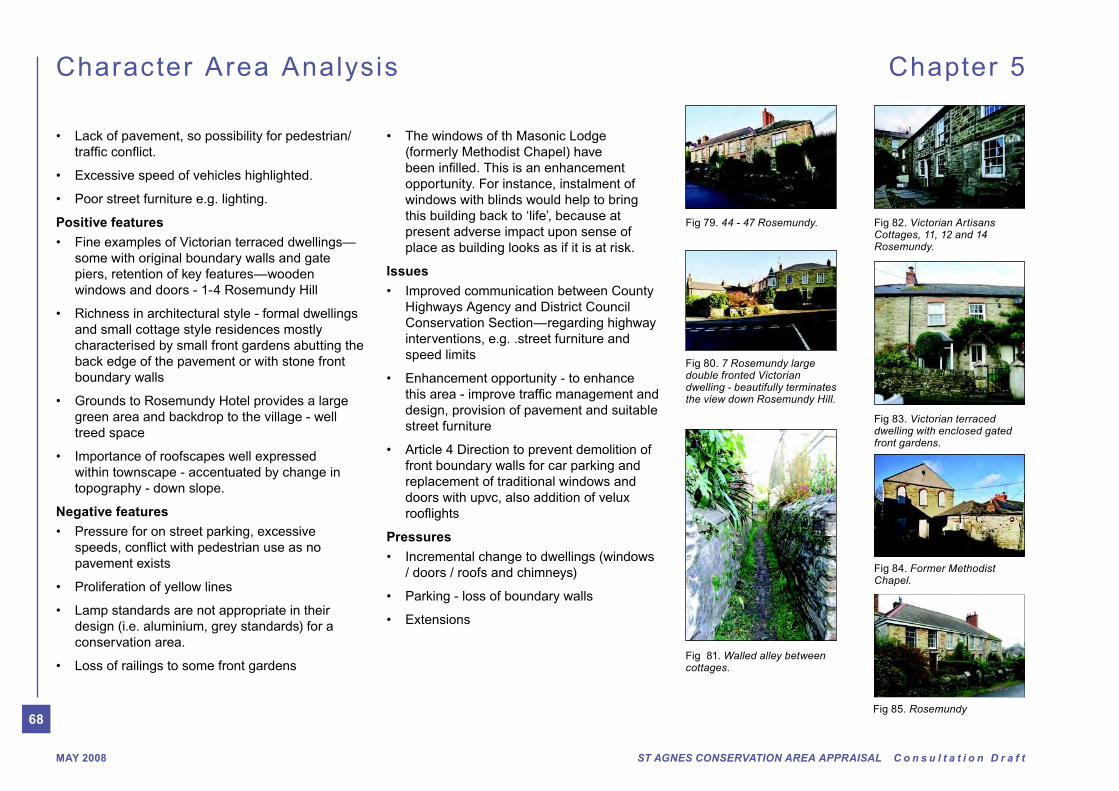
(formerly Methodist Chapel) have
opportunity. For instance, instalment of
windows with blinds would help to bring
this building back to ‘life’, because at
present adverse impact upon sense of
place as building looks as if it is at risk.
Issues
Highways Agency and District Council
Conservation Section—regarding highway
interventions, e.g. .street furniture and
speed limits
design, provision of pavement and suitable
street furniture
front boundary walls for car parking and
replacement of traditional windows and
doors with upvc, also addition of velux
Pressures
/ doors / roofs and chimneys)
Positive features
some with original boundary walls and gate
piers, retention of key features—wooden
windows and doors - 1-4 Rosemundy Hill
and small cottage style residences mostly
characterised by small front gardens abutting the
back edge of the pavement or with stone front
boundary walls
green area and backdrop to the village - well
treed space
within townscape - accentuated by change in
topography - down slope.
Negative features
pavement exists
design (i.e. aluminium, grey standards) for a
conservation area.
Fig 83. Victorian terraced dwelling with enclosed gated front gardens.
Fig 79. 44 - 47 Rosemundy.
Fig 84. Former Methodist Chapel.
Fig 80. 7 Rosemundy large double fronted Victorian dwelling - beautifully terminates the view down Rosemundy Hill.
Fig 82. Victorian Artisans Cottages, 11, 12 and 14 Rosemundy.
Fig 85. Rosemundy
Fig 81. Walled alley between cottages.
69
ST AGNES CONSERVATION AREA APPRAISAL C o n s u l t a t i o n D r a f t MAY 2008
Character Area Analysis Chapter 5
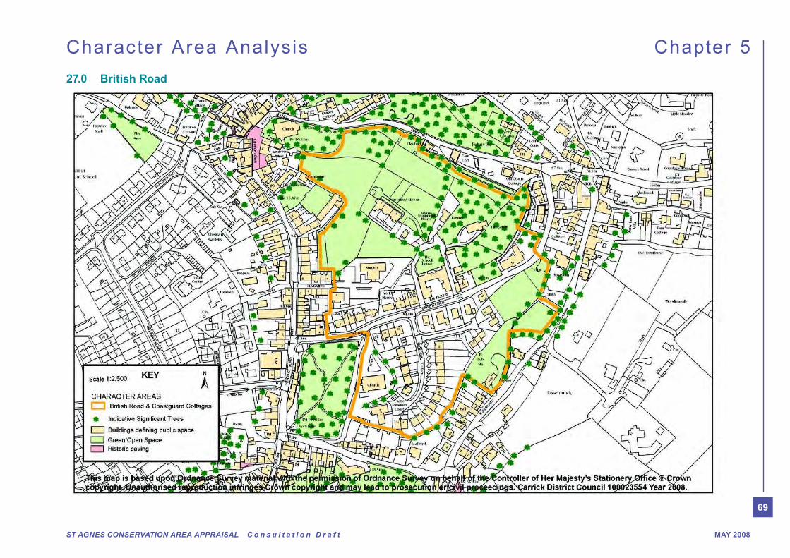
27.0 British Road
70
ST AGNES CONSERVATION AREA APPRAISAL C o n s u l t a t i o n D r a f tMAY 2008
Character Area Analysis Chapter 5
some with lawns and planting, help to soften the
stone facades of the buildings along the northern
side of the street. The meadows on the southern
side help to create a green link to the open
into and out of the conservation area. Excellent far
reaching views from the coastguard buildings on
the hill, also provide a green well treed backdrop to
the heart of the village emphasised by the height of
this part of landscape.
Development has grown sporadically along British
Road with the bank and adjacent buildings (at the
top of the road; bordering Vicarage Road) dating
from early to mid 19th century (1809-1841); along
with no 10 in the centre (northside) of the street and
the terrace 17-19 British Road close to Peterville
Square, and St Agnes Gardens of Rest.
Mid to late 19th century buildings (when the gaps
building, the castle, no’s 15 and 16, 20 and 21
(villas) and the Methodist Chapel adjacent to the
gardens. Later Victorian townhouses were built
opposite the gardens at no’s 5 to 8. These buildings
are a collective palette of local granite stone,
wooden facias, windows and doors, natural slate
roofs.
The more recent bungalow development at Castle
Meadows, whilst inappropriate in form and density
does not cause a negative impact upon the
is to enable control over future development which
may have an impact on the Conservation area.
The ambient atmosphere here is generally a quiet
circuit on a one way route.
British Road holds some great treasures in terms
of architectural and historic qualities, including the
with original boundary walls and gate piers, and
retention of key features such as wooden doors and
windows. Comparison of present day to historic/old
photos show very little change in the architectural
essence of this place. However, front railings have
disappeared due to the war effort. Reinstatement
would add positively here.
The richness in architectural style between
the large formal dwellings and small cottages
(Peterville end of road) adds to the special interest
of this particular character area. The importance
of roofscapes within the conservation area is
well expressed within this part of the landscape,
accentuated by the change in topography (down
the slope). However, care needs to be taken when
appear to cause clutter on roof elevations and one
would suggest that further control is needed.
The work of the local improvements committee is
evident at the top of British Road. Enhancement
to the Gardens of Rest, its entrance and a seating
area/new bus shelter and notice board all add
positively to the conservation area and is very much
supported by the District Council Conservation
Section.
parking are a key issue in this area. Copious
amounts of cars parked on the roadside (apparently
unaware of the allocated spaces to the rear of the
27.1 British Road Character Summary
Compared to Rosemundy and Town Hill, British
Road is more business like in appearance; it acts
as a transition from the mid 19th century expansion
of St Agnes to the older core of Peterville. As
such it has important remnant pockets of rurality,
House (Cleaderscroft Hotel); closer inspection
of the setting reveals the extension cuttings,
embankments and retaining walls associated with
the engineering of the road.
A one way road, British Road links Peterville to
Vicarage Road. The current prevailing uses are
predominantly residential properties (with the
former school building now residential) and a
dentist.
The road follows the curved contours which start
at the base of Coastguards Hill, to Peterville in
the valley below the main part of the village. At
its western edge (top of the road) where it meets
Vicarage Road, the buildings are in the form of
terraced two storey dwellings, facing onto St Agnes
Gardens of Rest. This then continues with further
terraces and large individual villa style dwellings,
ending in a small terrace of cottages, the former
at the bottom of the hill in Peterville. Many of
these properties have small front gardens with
stone boundary walls abutting the back edge of
pavement/road. The cohesive boundary treatment
creates a good sense of enclosure and emphasises
the ‘sweeping’ bend of the road.
The importance of retaining such structures needs
to be supported by Article 4 Direction as loss of
these features would be detrimental to these areas.
In terms of landscape, the small front gardens,
71
ST AGNES CONSERVATION AREA APPRAISAL C o n s u l t a t i o n D r a f t MAY 2008
Character Area Analysis Chapter 5
converted school.) These can block access for
vehicles emerging from side lanes i.e. coastguard.
British Road is a busy ‘through route’. There have
been several incidences where lorries and buses
have hit boundary walls causing damage. These
issues could be eliminated by improved highway
interventions e.g. street furniture and speed limits.
The street sign at the top of British Road is in poor
condition and needs an appropriate replacement.
Local concern regarding speed of vehicles using
this one way street has been highlighted during the
initial consultation process.
Overall, the quality of this area is very good. The
buildings are generally positive, in terms of the
appearance and character on the northern side of
the road. Whilst the more modern bungalow estate
may be bland in detail it is not considered to cause
a gross negative impact upon the character and
appearance of the Conservation Area.
The key enhancement opportunities for this area
and the design of street furniture; an Article for
4 Direction for the protection of front boundary
walls and prevention of replacement of traditional
windows and doors with upvc and addition of
Further support for the ongoing works of the local
improvements committee within the village.
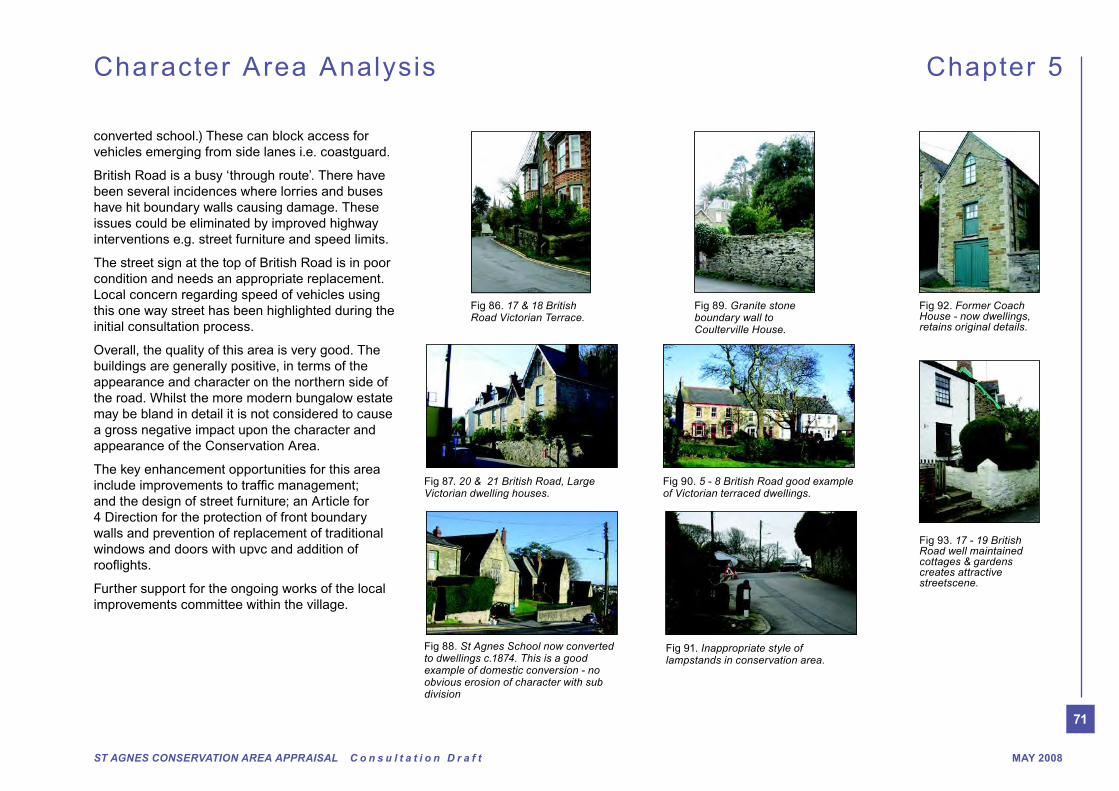
Fig 86. 17 & 18 British Road Victorian Terrace.
Fig 87. 20 & 21 British Road, Large Victorian dwelling houses.
Fig 90. 5 - 8 British Road good example of Victorian terraced dwellings.
Fig 89. Granite stone boundary wall to Coulterville House.
Fig 93. 17 - 19 British Road well maintained cottages & gardens creates attractive streetscene.
Fig 91. Inappropriate style of lampstands in conservation area.
Fig 88. St Agnes School now converted to dwellings c.1874. This is a good example of domestic conversion - no obvious erosion of character with sub division
Fig 92. Former Coach House - now dwellings, retains original details.

72
ST AGNES CONSERVATION AREA APPRAISAL C o n s u l t a t i o n D r a f tMAY 2008
Views and vistas
and out of the conservation area. Excellent far
reaching views from the coastguard buildings on
the hill.
Focal Points
stone boundary walls.
Noise levels (ambient character)
the hill during the day, but generally it is a quiet
residential area.
Building type/architectural style
school create interest and richness, whilst the
more modern housing estate appears rather
bland and at odds with the traditional terrace
form.
Listed Buildings
information in the appendix for details of all listed
buildings. Some of the most notable buildings
here are: Former St Agnes School building,
Listed Building Grade II, Coastguard Cottages
Listed Building Grade II, large Methodist Chapel,
Listed Building Grade II.
Unlisted buildings - of interest/townscape merit
Villa, 5-8 British Road Victorian terraced
dwellings, The Castle (located on the hill) late
19th Century dwelling, 17-19 British Road.
Schedule Ancient Monuments
Unique/unusual features
properties
Overall quality of built and natural environment
of appearance and character on the northern
side of the road. Whilst the modern estate may
be bland it does not cause a gross negative
impact upon the character or appearance of the
conservation area. Highway interventions and
the general pressure for on street parking have
caused vehicles to collide with boundary walls
causing damage to historic fabric. Local people
have raised concerns regarding the excessive
size and speed of vehicles in this locality. Better
design quality for street furniture is required.
Positive features
some with original boundary walls and gate
piers, retention of key features—wooden
windows and doors
and small cottage style residences mostly
characterised by small front gardens abutting
the back edge of the pavement, with stone front
boundary walls
Character Area Analysis Chapter 5
27.2 British Road General Description
Activity & Uses
Vicarage Road. The road accommodates mostly
residential properties, with the former school
now residential and a dentist.
Townscape/Morphology
the base of Coastguards Hill to Peterville in the
valley below the main part of the village. At its
western edge (top of the road) where it meets
Vicarage Road, the buildings are in the form of
terraced two storey dwellings, facing onto St
Agnes Garden of Rest. This then continues with
further terraces and individual large villa style
dwellings ending in a small terrace of dwellings
and the former smithy at the bottom of the hill in
Peterville. Many of these properties have small
front gardens with stone boundary walls abutting
the pavement.
terraced dwellings at the Peterville end, with
a large meadow separating it from the more
modern housing estate known as Castle
Meadows.
Trees, landscape, spaces & gardens
planting help to soften the stone facades of the
buildings - along the northern side of the street.
Whilst the meadow on the southern side helps
to create green link to the open countryside. The
hill behind creates a green, well treed backdrop
to the heart of the village.
73
ST AGNES CONSERVATION AREA APPRAISAL C o n s u l t a t i o n D r a f t MAY 2008
Character Area Analysis Chapter 5Character Area Analysis Chapter 5
countryside and village, enables distant views to
countryside and into village. It also forms a clear
link between the British Road and Rosemundy
character areas - with thru ‘open space’ helping
and backdrop to the village - well treed
to richness of conservation area
within townscape - accentuated by chimneys,
roof coverings, ridge details and change in
topography - down slope.
Negative features
roadside—may be contributing factor to some
instances of damage to historic fabric i.e.
damage to stone boundary walls by vehicles
design (i.e. aluminium, grey standards) for a
conservation area.
this one way street has been highlighted during
initial consultation process
poor condition
Issues
Highways Agency and District Council
Conservation Section—regarding highway
interventions, e.g. street furniture and speed
limits
street furniture
boundary walls for car parking and replacement
of traditional windows and doors with upvc, also
Committee regarding areas outside St Agnes
Gardens of Rest etc
Pressures
Coastguard Hill and ‘The Meadow’
Article 4 Direction control.
74
ST AGNES CONSERVATION AREA APPRAISAL C o n s u l t a t i o n D r a f tMAY 2008
Character Area Analysis Chapter 5
28.0 Polbreen Lane
75
ST AGNES CONSERVATION AREA APPRAISAL C o n s u l t a t i o n D r a f t MAY 2008
Character Area Analysis Chapter 5
28.1 Polbreen Lane Character Summary
This area includes St Agnes cemetery, Polbreen
Lane, part of Penwinnick Road, Goonvrea Road
and the southern end of Vicarage Road. It is
predominantly residential, other than the cemetery
and shops at the southern end of Vicarage Road
SPAR grocery shop. To the west of this area is the
large estate of bungalows off Polbreen Lane, its
bland uniformity is rather at odds with the dense
historically intricate centre of the village. However
to some extent it has retained original small holding
boundaries, predominantly along Polbreen Lane.
Due to its proximity to the (proposed) conservation
area, care should be taken with regard to changes
which may have an impact upon the conservation
area.
The area is largely all the same level, dipping
slightly on entering into Vicarage Road (from the
South). The townscape morphology is a mixed bag
of individual dwellings on large plots, both two and
single storey (e.g. bungalows), terraced dwellings,
both Victorian villa and town house styles and
cottages, some thatched, all of which create in
some parts, areas of richness in detail and design.
in the materials used, from cob, granite stone,
thatched and slate roofs in traditional cottages to
concrete rendered block of inter war bungalows.
There is some survival of original fenestration on
some buildings.
Most of the properties have small front gardens with
lawn areas and planting and retention of boundary
walls and gate piers.
Taking the right hand turning from the bungalow
estate into Polbreen Lane reveals a narrow single
lane which currently falls outside the present
Conservation Area boundary. This attractive
old green lane is enclosed on either side by
Cornish hedgerows and in parts is heavily treed
creating a fantastic canopy, it is a good example
of an old mining route. The extension of the
conservation area boundary to include this lane
would undoubtedly help to secure its future as
further parking and garages to serve the existing
the demise of its current ‘enclosed’ character.
Further along Polbreen Lane at its eastern end it
skirts around Sundew and April cottages which
cause a pinch point in the lane, it then opens up
around to reveal an enchanting informal square
of buildings, gheaded on its western boundary
by Langley cottage, a typical Cornish cottage
with rendered frontage backing onto the edge of
the road. The humble terrace of small cottages,
buildings and boundary walls inform the southern
edge of the lane and add interest in their rendered
from removal of overhead powerlines and a more
appropriate surface treatment material to the road
to add to its charm.
Southern end of Vicarage Road
The junction of Polbreen Lane and Vicarage Road
and grocers. Unfortunately, due to their appearance
character and appearance of the conservation area.
Indeed, devoid of richness in detail these buildings
create a hole in the fabric of the Conservation Area.
If redevelopment is proposed at any time in
the future, good quality appropriate building
replacements would create a positive enhancement
could be a key shop front enhancement scheme.
Helping to upgrade the quality of shop fronts in
this part of St Agnes. The entrance into St Agnes
also needs enhancement to create a space with a
clear identity, easy to orientate and an immediate
feeling/recognition of sense of place. As one of the
workshop members described this area “this area
is the business card of the village, its character is
small scale and intimate”.
placed especially at the roundabout into the village
(Road/Goonvrea Road/Vicarage road junction).
Goonvrea Road
Goonvrea Road, the western entrance into
St Agnes, is a mix of traditional cottages and
bungalows with later development along its
southern edge. The majority of dwellings are
detached, all with front gardens facing onto
the road. The quality of this particular space is
front boundary walls/hedges and planting giving
a softness to this edge of village location. Enys
Cottage is one of the most notable buildings, its
thatched roof adds a good deal of character to the
streetscene.

76
ST AGNES CONSERVATION AREA APPRAISAL C o n s u l t a t i o n D r a f tMAY 2008
Character Area Analysis Chapter 5
from the cemetery towards St Agnes beacon
and westward can be appreciated. Conversely,
the open area of the cemetery allows for far
reaching views out of the conservation area
the south west of the village. All other views
are local along roads often enriched by
buildings. To the south west of the cemetery
is Bolsters Dyke an archaeological site. This
is a scheduled ancient monument (separate
designation) and as such is protected.
The main issues here are to improve
communication between the County
Highways Department and the District Council
Conservation Section regarding highway
interventions; to enhance the area by improving
and dwellings; and an Article 4 Direction to
prevent demolition of front boundary walls for
car parking.
28.2 Penwinnick Road
The southern entrance/exit to the village is marked
by the roundabout junction. The roundabout has no
major built frontage (except for the hedge/boundary
area feels like a rather large space with very little
promise of the wealth and charm to be experienced
within the village.
Penwinnick villas, a pair of town houses on the west
side of the road and the dwelling opposite do help
to frame this part of the road having only small set
backs with front boundary walls.
The museum building to the west of the road is
trees. The pair of chapels (presumably one for
Church of England and one for non-conformists)
roof form and rich details and materials including
the ornamental eaves, oak windows and doors.
lies behind the building. The original part of the
cemetery has established, well treed Cornish hedge
pathway and detailed carved granite headstones.
Some planting is evident in the form ‘boxed’ trees
giving it a simple low maintenance ambience. It
is unfortunate that the more recent extension to
the cemetery lacks any ‘sense of place’. A former
smooth shiny head stones and lack of planting and
landscaping appears to be stark and sterile and in
effect bereft of intimacy. The addition of planting /
landscaping here would make it into a place which
was more enjoyable to visit, where people can sit
‘comfortably’ and be close to loved ones. Fine views
Fig 97. Good example of interwar bungalows, e.g. ‘Greencaps’.
Fig 99. Former Chapel now St Agnes Museum.
Fig 94. Terrace of small cottages along Polbreen Lane.
Fig 95. Thatched cottage, Goonvrea Road.
Fig 96. Victorian Terrace, 65 & 66 Vicarage Road.
Fig 102. Good e.g.s of traditional head stones— St Agnes Cemetery.
Fig 101. Opportunity for enhancement?
Fig 98. entrance inappropriate.
Fig 100. Opportunity for enhancement - main access/entrance into village.
77
ST AGNES CONSERVATION AREA APPRAISAL C o n s u l t a t i o n D r a f t MAY 2008
Character Area Analysis Chapter 5
28.3 Polbreen Lane General Description
Focal Points
into St Agnes. Although dominated by the road
and roundabout. This area could be enhanced
to make a focal nodal point and key ‘gateway’
point.
Noise levels (ambient character)
as this is one of the main access points into the
village, but generally it is a quiet predominantly
residential area. In contrast Polbreen Lane is
especially quiet possibly due to it being narrow
and a no through route. Penwinnick Road and
Vicarage Road are busy through routes.
Building type/architectural style
from thatched Cottages and Victorian terraced
Villas.
Listed Buildings
information in the appendix for details of all listed
buildings. Some of the most notable buildings
here are: Rose and Coombe cottages, and the
Cemetery Chapels, gate and gate piers all grade
II listed buildings.
Unlisted buildings - of interest/townscape merit
and the plot redeveloped with two modern
houses, interwar bungalows to the south of the
cemetery, South End Cottage 55 - 61 Vicarage
Road, Vicarage Road, Victorian Villas and
Sundew Cottage /April Cottage amongst others.
Schedule Ancient Monuments
Bolster’s Dyke.
Unique/unusual features
and windows on some properties
Overall quality of built and natural environment
The buildings are generally positive, in terms of
appearance and character in this area. Although the
modern bungalow estate may be considered to be
architecturally bland, it has to some extent retained
original small holding boundaries, predominantly
near Polbreen Lane. Due to its proximity to the
conservation area care should be taken with regard
to changes which may have an impact upon the
character and appearance of the conservation area.
This area also holds one of the key access points
into the village at the junction of Goonvrea and
Vicarage Roads, this small roundabout junction has
been highlighted by local people as being an area
ripe for enhancement.
Pressures
utilities
boundary erosions.
Activity & Uses
Polbreen Lane, and part of Vicarage Road.
It is predominantly residential, other than the
cemetery and shops at the southern end of
Vicarage Road, - Fish Shop, Newsagents and
Spar Grocery shop.
Townscape/Morphology
slightly on entrance into Vicarage Road. The
townscape morphology is a mixed bag of
individual dwellings on large plots, terraced
dwellings both Victorian villa and town house
styles and cottages, some thatched.
Trees, landscape, spaces & gardens
with lawn areas and planting. Polbreen Lane is
heavily treed on either side - a good example
of an old mining route now a green lane. The
cemetery appears to have two characteristic
areas, the older part being screened by well
treed Cornish hedges the newer extension
bounded by hedges but bare of trees.
Views and vistas
reaching views out of the conservation area
southwest of the village. All other views are local
- along roads often punctuated by buildings.
78
ST AGNES CONSERVATION AREA APPRAISAL C o n s u l t a t i o n D r a f tMAY 2008
Character Area Analysis Chapter 5
Issues
Highways Agency and District Council
Conservation Section— regarding highway
interventions
shop fronts and street furniture to aid local
proprietors in maintaining and enhancing their
properties in a manner sympathetic to the
character and appearance of the conservation
area
shop fronts and dwellings
boundary walls for car parking
Throughout the survey work and initial public
consultation, one of the key issues most discussed
is that of the quality of the streetscape in St Agnes
and the effect of highway interventions upon it.
Positive features
cottages to Victorian villas, interwar and modern
bungalows some retention of boundary walls and
gate piers, wooden windows and doors
properties help to provide activity through the
day, edge of settlement however, makes this a
quiet area
dwellings and small cottage style residences
mostly characterised by small front gardens
or properties abutting the back edge of the
pavement
Lane and Goonvrea Road help to maintain a
‘green’ appearance to this area.
Negative features
highway— inappropriate forms of signage i.e.
street names on plastic rather than metal signs
effect upon the character and appearance of the
conservation area and streetscene in general.
shop building
of street markings, roundabout etc
79
ST AGNES CONSERVATION AREA APPRAISAL C o n s u l t a t i o n D r a f t MAY 2008
Chapter 6C
urre
nt Is
su
es
& C
ap
ac
ity
for C
ha
ng
e
“Generic issues that underline obvious problem s should be
Article 4 Directions!”
“Involving the com munity should be an integral part of the
appraisal process and should be approached in a pro-active
and innovative way”
“An im portant aspect of the appraisal process will be
considering where the boundary of the conservation area
should be drawn”
English Heritage, 2005
80
ST AGNES CONSERVATION AREA APPRAISAL C o n s u l t a t i o n D r a f tMAY 2008
Current issues & Capacity for Change Chapter 6
W hat could be an interesting sequence of ‘urban’
spaces (Vicarage Road/Goonvean Road junction,
Vicarage shopping area, the area around the
Miner’s and Mechanic’s Institute, Rosemundy, and
above all Peterville), are already treated simply as
road junctions with little apparent thought given to
streetscape value.
29.4 Management of historic buildings
The degree of careful management of historic
buildings that is very evident in Churchtown needs
to be extended to other areas - e.g. the shops at
from coordinated attempt to improve the quality
of frontages, and to remove existing details not
in keeping with the high quality of the historic
environment.
29.5 Setting of the conservation area
Because of the topographical characteristics
of the settlement, and the high degree of
permeability and public access within and
through St Agnes, there are few buildings
or sites which are not to some extent visible
to the public realm, or impact on nearer or
farther views of the place and upon its historic
character. Roofs, rear and side elevations,
back land developments, extensions into rear
plots all, therefore tend to have more of an
impact than they might elsewhere. Combined
with the very high quality of the built and
natural historic environment, this places a
very high premium on good quality of design,
materials, and consideration of impact of any
development in and around the village, both
within and outside the conservation area.
29.6 Future growth - housing and community
facilities
The need to provide for further housing and
community facilities in and around St Agnes will
importance of open space and undeveloped land
within and immediately adjacent to the settlement
core areas. These have already to some extent
been protected in individual case histories, but the
special character of the settlement an conservation
area and the need to protect them cannot be
overemphasised.
29.7 Archaeological Potential and Historical
recording
In historical and archaeological terms, the
remnant mining landscapes are important as
integrated wholes - mere concentration on obvious
‘monuments’ like chimneys at the expense of the
outbuildings, walls, dumps, shafts, cottages, count
This is a particularly live issue in St Agnes, where
much within the village has already been developed
for housing (without always proper archaeological
investigation or recording), and where the location,
history and scale of works are critical to an
character of the historic settlement.
The St Agnes Conservation Area Management
Plan shows how enhancement could be achieved in
Churchtown and Peterville and how these address
the aforementioned concerns.
management engineering and signs; the one-
speeding down Town Hill and up British Road. Also
through the village are often at odds with the narrow
width of the carriageway, which on occasion results
in damage to property in particular boundary walls.
One lady who lives in British Road has had the
boundary all to her property rebuilt twice due to
appears to be further exacerbated by the amount
of cars parked on the side of the street as many
properties do not have off street parking due to
their traditional enclosed front gardens abutting the
highway.
29.2 Signage
Signs in general are too dominant in Churchtown
and Peterville - the latter area in particular is
and commercial signs resulting in visual clutter
and an adverse impact upon the character and
appearance of the conservation area.
29.3 Streetscape and spaces
On the whole the management of the historic
fabric in St Agnes is relatively good, however, the
management is of paramount importance, due
to its impact upon the historic environment. The
importance of historic surfacing, the adverse impact
of signs, roundabouts, street markings and other
ephemera are issues that need to be addressed.
29.0 Current issues & Capacity for Change

81
ST AGNES CONSERVATION AREA APPRAISAL C o n s u l t a t i o n D r a f t MAY 2008
Current issues & Capacity for Change Chapter 6
Conservation Areas: The Process of Designation and Review
Survey of area and draft character appraisal and policies for preservation and enhancement written by District Council.
Informal consultation with local people.
Report to Executive Member on proposed Conservation Area.
DECISION:
Proceed with formal
consultation
Formal consultation on the designation with local residents, businesses, interest groups and English Heritage.
Review the consultation and make any necessary amendments.
Report to Executive Member on the consultation process, with a recommendation on whether or not to designate or amend an existing area.
DECISION:
Designate/Amend
Conservation Area is designated or amended.
Process stops
Process stops
Yes
Yes
No
No
30.0 Community Involvement
Methodology and process of public consultation
30.1 Informal Consultation with members of the
Public (January 2005). A public meeting was held on
the evening of Monday 17th January 2005 in St Agnes
Methodist church hall to seek comments and opinions
from local people. To be included in the draft appraisal.
30.2 A ‘walk and workshop’ was held on Saturday 22nd
January, with local people forming 5 groups to assess
the study area, i.e. existing and proposed conservation
area. The analysis and comments compiled on the day
are to be included in the draft appraisal document.
30.3 Draft Appraisal Document. Completion of Draft
appraisal document by beginning of January 2007.
30.4 Draft appraisal put to Executive members –
Planning (Development Control) Committee, Cabinet
and Policy Development Board for approval to go out for
formal public consultation.
30.5 Formal Public Consultation Process. A draft
will be added to Carrick’s website accompanied by an
electronic comments sheet/feedback form; and use of
the media and press releases.
30.6 An exhibition will be prepared for the general
public and a comments book produced to accompany
the exhibition which will be run by Carrick – perhaps
opinions received analysed for inclusion/approval of
Draft Appraisal.
30.7 Final Conservation Area Appraisal production.
in an A4 format with the inclusion of maps and
supporting information. It will explain how the input from
the community was evaluated and how it was taken
recommendations for, the area.
82
ST AGNES CONSERVATION AREA APPRAISAL C o n s u l t a t i o n D r a f tMAY 2008
Current issues & Capacity for Change Chapter 6
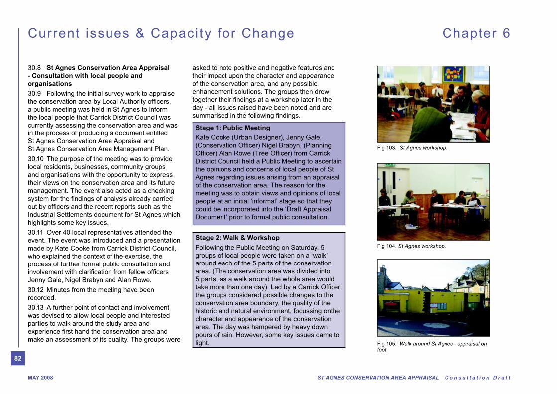
Fig 103. St Agnes workshop.
Fig 105. W alk around St Agnes - appraisal on foot.
Fig 104. St Agnes workshop.
30.8 St Agnes Conservation Area Appraisal
- Consultation with local people and
organisations
30.9 Following the initial survey work to appraise
a public meeting was held in St Agnes to inform
the local people that Carrick District Council was
currently assessing the conservation area and was
in the process of producing a document entitled
St Agnes Conservation Area Appraisal and
St Agnes Conservation Area Management Plan.
30.10 The purpose of the meeting was to provide
local residents, businesses, community groups
and organisations with the opportunity to express
their views on the conservation area and its future
management. The event also acted as a checking
Industrial Settlements document for St Agnes which
highlights some key issues.
30.11 Over 40 local representatives attended the
event. The event was introduced and a presentation
made by Kate Cooke from Carrick District Council,
who explained the context of the exercise, the
process of further formal public consultation and
Jenny Gale, Nigel Brabyn and Alan Rowe.
30.12 Minutes from the meeting have been
recorded.
30.13 A further point of contact and involvement
was devised to allow local people and interested
parties to walk around the study area and
make an assessment of its quality. The groups were
asked to note positive and negative features and
their impact upon the character and appearance
of the conservation area, and any possible
enhancement solutions. The groups then drew
day - all issues raised have been noted and are
Stage 1: Public Meeting
Kate Cooke (Urban Designer), Jenny Gale,
District Council held a Public Meeting to ascertain
the opinions and concerns of local people of St
Agnes regarding issues arising from an appraisal
of the conservation area. The reason for the
meeting was to obtain views and opinions of local
people at an initial ‘informal’ stage so that they
could be incorporated into the ‘Draft Appraisal
Document’ prior to formal public consultation.
Stage 2: W alk & W orkshop
Following the Public Meeting on Saturday, 5
groups of local people were taken on a ‘walk’
around each of the 5 parts of the conservation
area. (The conservation area was divided into
5 parts, as a walk around the whole area would
the groups considered possible changes to the
conservation area boundary, the quality of the
historic and natural environment, focussing onthe
character and appearance of the conservation
area. The day was hampered by heavy down
pours of rain. However, some key issues came to
light.
83
ST AGNES CONSERVATION AREA APPRAISAL C o n s u l t a t i o n D r a f t MAY 2008
30.14 Positive/Negative features and
enhancement possibilities. The individual positive
and negative features and possible enhancement
opportunities were read out to the participants
by each group leader and were noted under the
following themes:
Directions
The positive and negative features that were
in detail in a separate report on the consultation
Current issues & Capacity for Change Chapter 6
30.15
Changes to Conservation Area Boundary
Some of the views aired at the Public Meeting
were unsupportive of an extension to the existing
Conservation Area, with one of the main reasons
being, “Carrick District Council needs to prove that
it will take care of the existing conservation area
before it seeks to extend it.”
30.16 Others were supportive of the proposed
extensions, as highlighted during the ‘Walk
& Workshop’ event when 4 out of 5 of the
groups agreed with the proposals to extend the
conservation area. One group, which assessed
the Polbreen Lane, St Agnes Cemetery area were
unsure of the reasons for extension in this particular
area. It was explained during the summary of the
session that the area held remnants of mining
works and plots, small holding boundaries , some
important Listed Buildings, buildings of townscape
merit and Polbreen Lane itself, and was key to
protecting the setting of the conservation area.
30.17 Townscape Quality It was generally
acknowledged that the quality of the existing
townscape is predominantly good. However, it
was noted that where poor buildings/structures
did exist within the conservation area, they
should be the focus of enhancement schemes
should development proposals come forward
i.e. The Meadery (former Odd Fellows Hall) on
Vicarage Road, where the additions and changes
to its façade and boundary are considered to be
inappropriate and create a ‘tatty’ appearance.
30.18 Environmental Quality
indicate that the overall quality of the environment
was good. Some areas within the village also
required careful management and maintenance
such as the public realm areas of Churchtown,
Peterville and well treed areas, i.e. the grounds of
Rosemundy Hotel to reach their full potential. Whilst
be a major problem within the village, it was felt that
the importance of maintenance and management of
the historic, built and natural environment needed to
be highlighted.
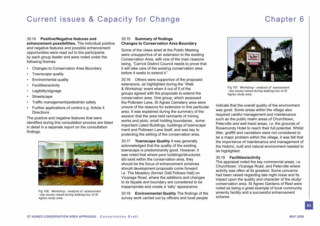
30.19 Facilities/activityThe appraisal noted the key commercial areas, i.e. Churchtown, Vicarage Road, and Peterville where activity was often at its greatest. Some concerns had been raised regarding late night noise and its impact upon the quality and character of the study/conservation area. St Agnes Gardens of Rest were noted as being a great example of local community amenity facility and a successful enhancement scheme.
Fig 106. Workshop - analysis of assessment - key issues raised during walking tour of St Agnes study area.
Fig 107. Workshop - analysis of assessment - key issues raised during walking tour of St Agnes study area.
84
ST AGNES CONSERVATION AREA APPRAISAL C o n s u l t a t i o n D r a f tMAY 2008
30.20 SignageSome areas within the study area, such as Churchtown and Peterville exhibited an over zealous proliferation of both commercial and highway signage to the detriment of the character and appearance of the conservation area and settlement as a whole.
30.21 It was also noted that recent replacement street/road name signs were made of plastic, rather than the black and white traditional metal styles. Uniformity for traditional signage in keeping with the character of the conservation area was thought to be more appropriate.
30.22 It was agreed that one of the aims arising from this appraisal was to produce clear guidance on the appropriate form and amount of signage for commercial and highway signage.
30.23 StreetscapeHighway interventions and the loss or covering of historic paving surfaces was clearly a key issue with regards to quality in the streetscape of St Agnes. A key issue regarding street furniture was raised, as
Current issues & Capacity for Change Chapter 6
being a contributing factor to the overall appearance and quality of the conservation area. It was felt that lamp standards, railings etc were often of poor or inappropriate design/materials for the conservation area and guidance was needed in order to combat this problem.
30.24 General theme of evident poor communication between and within agencies i.e. between County Highways Agency and the Conservation and Planning Sections of Carrick District Council and Cornwall County Council. An example often used to illustrate this is the covering of historic paving materials, i.e. cobbles in Churchtown, the proliferation of road markings, highway signage and paraphernalia within the village. Design guidance, communications with appropriate sections of the Council and use of less intrusive alternatives (i.e. small signage to highlight parking areas rather than yellow lines) would all help to create a better managed and better quality appearance of the conservation area.
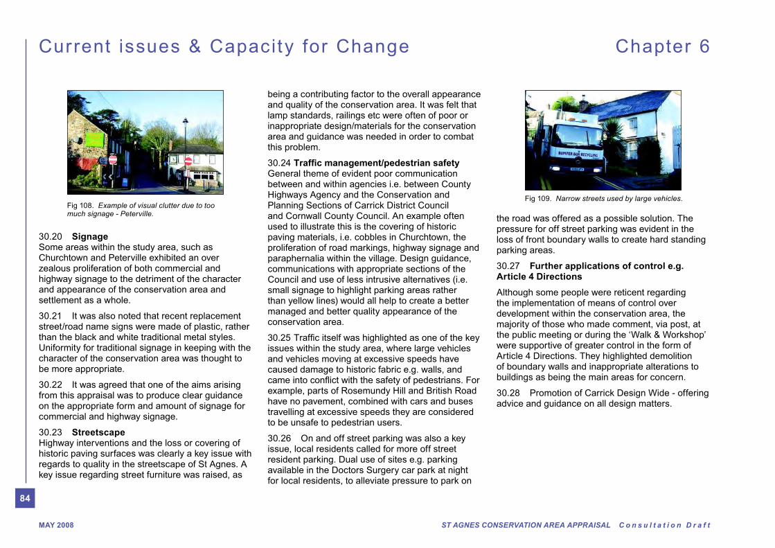
issues within the study area, where large vehicles and vehicles moving at excessive speeds have caused damage to historic fabric e.g. walls, and
example, parts of Rosemundy Hill and British Road have no pavement, combined with cars and buses travelling at excessive speeds they are considered to be unsafe to pedestrian users.
30.26 On and off street parking was also a key issue, local residents called for more off street resident parking. Dual use of sites e.g. parking available in the Doctors Surgery car park at night for local residents, to alleviate pressure to park on
the road was offered as a possible solution. The pressure for off street parking was evident in the loss of front boundary walls to create hard standing parking areas.
30.27 Further applications of control e.g. Article 4 Directions
Although some people were reticent regarding the implementation of means of control over development within the conservation area, the majority of those who made comment, via post, at the public meeting or during the ‘Walk & Workshop’ were supportive of greater control in the form of Article 4 Directions. They highlighted demolition of boundary walls and inappropriate alterations to buildings as being the main areas for concern.
30.28 Promotion of Carrick Design Wide - offering advice and guidance on all design matters.
Fig 108. Example of visual clutter due to too much signage - Peterville.
Fig 109. Narrow streets used by large vehicles.
85
ST AGNES CONSERVATION AREA APPRAISAL C o n s u l t a t i o n D r a f t MAY 2008
31.3 East side of Vicarage Road and
Rosemundy House
The Goonown Road approach to the village
shares many of the qualities of other historic
approaches to St Agnes: mature trees, Cornish
hedges, gates and mature planting produce a
distinct character here and are an important
remnant of the of the once rural approach to
the village from the south east. This proposed
boundary extension includes the Listed 18th
century Rosemundy House and its extensive
grounds, and the historic buildings fronting the
southern end of Vicarage Road which make
a positive contribution to the historic character
and main southern approach to St Agnes. The
boundary would take the line of the Cornish
hedge on the eastern side of Goonown Road -
see map Fig 110.
31.4 Penwinnick Road and Polbreen Lane
Mining is of crucial historic interest and
landscape and early 19th century small holding
pattern in and around Polbreen Lane are
included here to illustrate and recognise this
importance. Also included is the St Agnes
Museum building, formerly the Chapel of Ease,
together with the historic cemetery and boundary
wall which make a positive contribution to the
southern entrance of St Agnes along Penwinnick
Road.
31.5 Trevaunance Road & north side of
Churchtown
It is proposed to extend the conservation area
boundary along Trevaunance Road to include
that stand in their own mature gardens with good
trees and boundary walls; the interwar bungalow
development north of Churchtown where
properties are set in larger than average plots,
and building remnants associated with West
Kitty.
31.6 Quay Road / Peterville
Open spaces form the boundaries to the urban
historic settlement. It is proposed to extend the
conservation area boundary along Quay Road
Stappy; the remnants of mining activity along
side of Quay Road set in characteristically large
mature gardens.
Extension to the northern boundary in the
Peterville area to include small-holding and
mining boundaries delineated by Cornish
hedges and to provide an adequate ‘buffer’ zone
for the setting of the conservation area. This
in particular has been under pressure recently
for development – largely residential which
has impacted upon views into and out of the
Conservation Area.
Current issues & Capacity for Change Chapter 6
31.1 Conservation Area Extensions
Carrick District Council has a responsibility
from time to time to consider whether further
extensions or reductions of Conservation
Areas are called for. This appraisal has
considered the extent of the existing St Agnes
Conservation Area and as a result the following
recommendations are made for extensions.
There are no recommendations for reducing the
St Agnes Conservation Area.
31.2 Rosemundy Road, East
Currently the eastern Conservation Area
boundary skirts the edges of the 20th century
development in Castle Meadows. The proposed
extension will draw in the meadowland between
Rosemundy Road and British Road. This
separated the two hamlets of Petersville
and Rosemundy and helps to illustrate the
development of the town from a series of
hamlets and farmsteads. Although the area
to be included has been damaged by 20th
century development in Castle Meadows it is
the town. Cornish hedges and mature planting
along the eastern edge of Rosemundy Road
produce a distinct character with houses only
glimpsed, shielded by boundary treatments
and their embanked locations above road level.
hedge that runs parallel to the road between
Rosemundy and Peterville.
31.0 Conservation Area Extensions
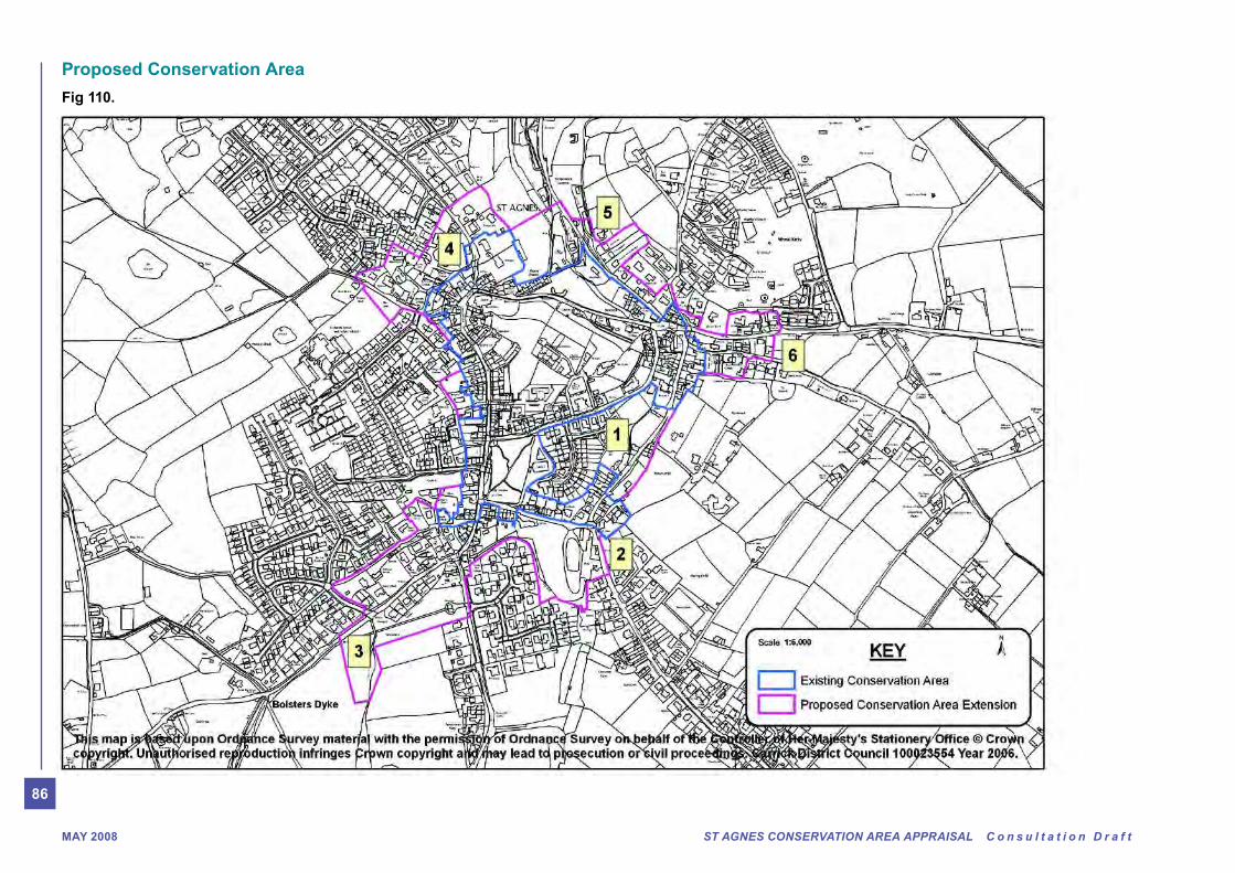
86
ST AGNES CONSERVATION AREA APPRAISAL C o n s u l t a t i o n D r a f tMAY 2008
Proposed Conservation Area
Fig 110.

87
ST AGNES CONSERVATION AREA APPRAISAL C o n s u l t a t i o n D r a f t MAY 2008
Chapter 7U
se
ful in
form
atio
n, a
pp
en
dic
es
&
co
nta
ct d
eta
ils

88
ST AGNES CONSERVATION AREA APPRAISAL C o n s u l t a t i o n D r a f tMAY 2008
Archaeological si tes and histor ic bui ldings Chapter 7
Codes: PRN: Primary Record Number in Cornwall Sites & Monuments Record. NGR: National Grid Reference. LB: Listed Building.
SM: Scheduled Ancient Monument.
Date: PA = Palaeolithic, ME =Mesolithic, NE = Neolithic, BA = bronze age, IA = iron age, RB = Roman British, EM = early medieval, MD = medieval,
PM = post medieval, PX= prehistoric undated, HX = historic undated, UX = unknown, C = century, c = approximately.
Ref. Street no. Name Road Site type Period Status SM or LB No PRN
01 Outbuilding adj. no 8 Trevaunance Road Outbuilding 1841-80
02 8 Trevaunance Road House 1908-46
03 6 Trevaunance Road House 1908-46
04 4 Castle House Trevaunance Road House 1809-41 LBII SW75 SW 4/220
05 2 The Vicarage Trevaunance Road Vicarage 1841-80 LBII SW75 SW 4/218
06 14b Churchtown Bakery 1809-41
07 3-9 (odd) Trevaunance Road House 1809-41 LBII SW75 SW 4/221
08 1 Trevaunance Road House 1908-46
09 West Kitty Mine 1863-1916 41345
10 Wall with building
fragments
West Kitty Wall with building
fragments
C19
11 Wall with building
fragments
West Kitty Wall with building
fragments
C19
12 The Vicarage - Gate Trevaunance Road 1841-80Gate piers and 1841-80 LBII SW75 SW 4/219
13 West Kitty Cottage West Kitty House 1841-80
14 St Corran Cottage,
Selwood Cottage
West Kitty House 1809-41
15 The Retreat, Wheal
Rock
West Kitty House 1809-41
16 Adj. Wayside West Kitty House 1880-1908
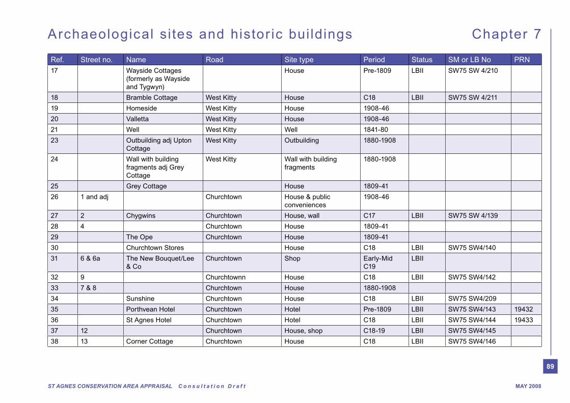
89
ST AGNES CONSERVATION AREA APPRAISAL C o n s u l t a t i o n D r a f t MAY 2008
Archaeological si tes and histor ic bui ldings Chapter 7
Ref. Street no. Name Road Site type Period Status SM or LB No PRN
17 Wayside Cottages
(formerly as Wayside
and Tygwyn)
House Pre-1809 LBII SW75 SW 4/210
18 Bramble Cottage West Kitty House C18 LBII SW75 SW 4/211
19 Homeside West Kitty House 1908-46
20 Valletta West Kitty House 1908-46
21 Well West Kitty Well 1841-80
23 Outbuilding adj Upton
Cottage
West Kitty Outbuilding 1880-1908
24 Wall with building
fragments adj Grey
Cottage
West Kitty Wall with building
fragments
1880-1908
25 Grey Cottage House 1809-41
26 1 and adj Churchtown House & public
conveniences
1908-46
27 2 Chygwins Churchtown House, wall C17 LBII SW75 SW 4/139
28 4 Churchtown House 1809-41
29 The Ope Churchtown House 1809-41
30 Churchtown Stores House C18 LBII SW75 SW4/140
31 6 & 6a The New Bouquet/Lee
& Co
Churchtown Shop Early-Mid
C19
LBII
32 9 Churchtownn House C18 LBII SW75 SW4/142
33 7 & 8 Churchtown House 1880-1908
34 Sunshine Churchtown House C18 LBII SW75 SW4/209
35 Porthvean Hotel Churchtown Hotel Pre-1809 LBII SW75 SW4/143 19432
36 St Agnes Hotel Churchtown Hotel C18 LBII SW75 SW4/144 19433
37 12 Churchtown House, shop C18-19 LBII SW75 SW4/145
38 13 Corner Cottage Churchtown House C18 LBII SW75 SW4/146

90
ST AGNES CONSERVATION AREA APPRAISAL C o n s u l t a t i o n D r a f tMAY 2008
Archaeological si tes and histor ic bui ldings Chapter 7
Ref. Street no. Name Road Site type Period Status SM or LB No PRN
39 Church of St Agnes Churchtown Parish Church C15-19 LBII* SW75 SW4/147 19409
ff
40 Cross at west end of St
Agnes Church
Churchtown Cross EM, Pre-
Conquest
LBII SW75 SW4/148 19408
41 Wall and lychgate,
Church of St Agnes
Churchtown Wall and lychgate Late C19 LBII SW75 SW4/149
42 Boundary wall to east
and south, Church of St
Agnes
Churchtown Boundary wall to east
and south
1841-80
43 15 Bank House Churchtown House Pre-1809 LBII SW75 SW4/150
44 16 Churchtown House and shop PRE-1809
45 Band Room Churchtown Band Room 1908-46
46 18 Churchtown Institute 1908-46
47 Paving Churchtown Paving Pre-1809
48 20 & 21 Churchtown Shop Early C19 LBII SW75 SW4/152
49 Churchtown House Pre-1809
50 22 & 23, Churchtown 1809-41
51 Cappaquin Vicarage Road House 1841-1908
52 Walled grade opposite
Opie’s Cottage
Vicarage Road Walled garden 1841-80
53 Wall adj Cappaquin Vicarage Road Walled garden 1841-80
54 Opie’s Cottage Vicarage Road House Pre-1809
55 32-34 (cons) Vicarage Road Terrace (3), wall and
gate pier
1809-41 LBII SW75 SW4/247
56 R/o 34 Vicarage Road Outbuilding 1841-1946
57 35 Vicarage Road Manse (to Methodist
chapel)
1809-41 LBII SW75 SW4/246
58 R/o 35 Outbuilding Vicarage Road Outbuilding 1809-41
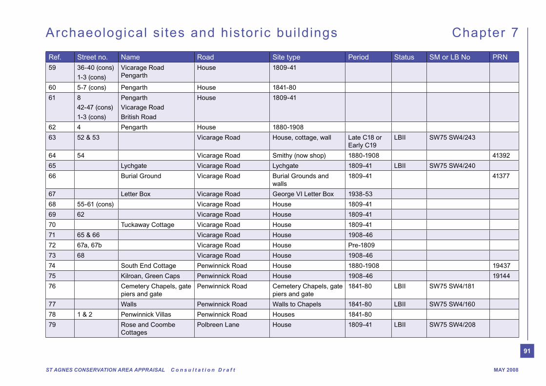
91
ST AGNES CONSERVATION AREA APPRAISAL C o n s u l t a t i o n D r a f t MAY 2008
Archaeological si tes and histor ic bui ldings Chapter 7
Ref. Street no. Name Road Site type Period Status SM or LB No PRN
59 36-40 (cons)
1-3 (cons)
Vicarage Road
Pengarth
House 1809-41
60 5-7 (cons) Pengarth House 1841-80
61 8
42-47 (cons)
1-3 (cons)
Pengarth
Vicarage Road
British Road
House 1809-41
62 4 Pengarth House 1880-1908
63 52 & 53 Vicarage Road House, cottage, wall Late C18 or
Early C19
LBII SW75 SW4/243
64 54 Vicarage Road Smithy (now shop) 1880-1908 41392
65 Lychgate Vicarage Road Lychgate 1809-41 LBII SW75 SW4/240
66 Burial Ground Vicarage Road Burial Grounds and
walls
1809-41 41377
67 Letter Box Vicarage Road George VI Letter Box 1938-53
68 55-61 (cons) Vicarage Road House 1809-41
69 62 Vicarage Road House 1809-41
70 Tuckaway Cottage Vicarage Road House 1809-41
71 65 & 66 Vicarage Road House 1908-46
72 67a, 67b Vicarage Road House Pre-1809
73 68 Vicarage Road House 1908-46
74 South End Cottage Penwinnick Road House 1880-1908 19437
75 Kilroan, Green Caps Penwinnick Road House 1908-46 19144
76 Cemetery Chapels, gate
piers and gate
Penwinnick Road Cemetery Chapels, gate
piers and gate
1841-80 LBII SW75 SW4/181
77 Walls Penwinnick Road Walls to Chapels 1841-80 LBII SW75 SW4/160
78 1 & 2 Penwinnick Villas Penwinnick Road Houses 1841-80
79 Rose and Coombe
Cottages
Polbreen Lane House 1809-41 LBII SW75 SW4/208
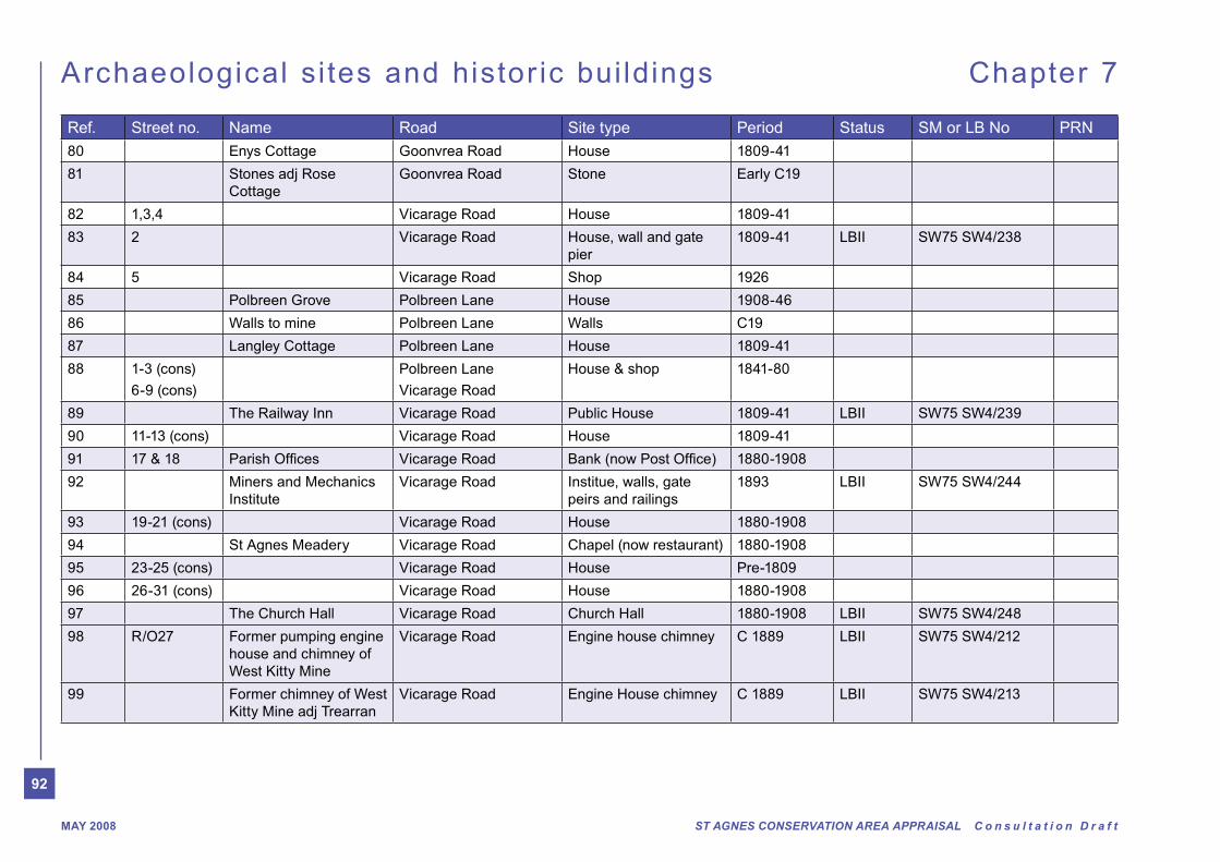
92
ST AGNES CONSERVATION AREA APPRAISAL C o n s u l t a t i o n D r a f tMAY 2008
Archaeological si tes and histor ic bui ldings Chapter 7
Ref. Street no. Name Road Site type Period Status SM or LB No PRN
80 Enys Cottage Goonvrea Road House 1809-41
81 Stones adj Rose
Cottage
Goonvrea Road Stone Early C19
82 1,3,4 Vicarage Road House 1809-41
83 2 Vicarage Road House, wall and gate
pier
1809-41 LBII SW75 SW4/238
84 5 Vicarage Road Shop 1926
85 Polbreen Grove Polbreen Lane House 1908-46
86 Walls to mine Polbreen Lane Walls C19
87 Langley Cottage Polbreen Lane House 1809-41
88 1-3 (cons)
6-9 (cons)
Polbreen Lane
Vicarage Road
House & shop 1841-80
89 The Railway Inn Vicarage Road Public House 1809-41 LBII SW75 SW4/239
90 11-13 (cons) Vicarage Road House 1809-41
91 17 & 18 Vicarage Road 1880-1908
92 Miners and Mechanics
Institute
Vicarage Road Institue, walls, gate
peirs and railings
1893 LBII SW75 SW4/244
93 19-21 (cons) Vicarage Road House 1880-1908
94 St Agnes Meadery Vicarage Road Chapel (now restaurant) 1880-1908
95 23-25 (cons) Vicarage Road House Pre-1809
96 26-31 (cons) Vicarage Road House 1880-1908
97 The Church Hall Vicarage Road Church Hall 1880-1908 LBII SW75 SW4/248
98 R/O27 Former pumping engine
house and chimney of
West Kitty Mine
Vicarage Road Engine house chimney C 1889 LBII SW75 SW4/212
99 Former chimney of West
Kitty Mine adj Trearran
Vicarage Road Engine House chimney C 1889 LBII SW75 SW4/213
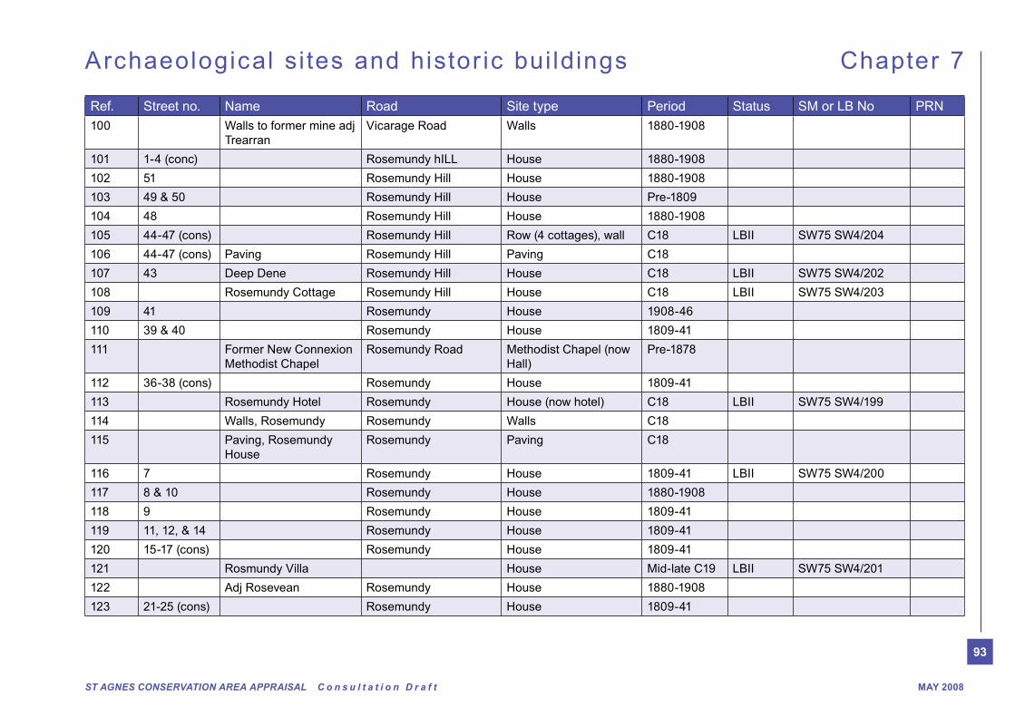
93
ST AGNES CONSERVATION AREA APPRAISAL C o n s u l t a t i o n D r a f t MAY 2008
Archaeological si tes and histor ic bui ldings Chapter 7
Ref. Street no. Name Road Site type Period Status SM or LB No PRN
100 Walls to former mine adj
Trearran
Vicarage Road Walls 1880-1908
101 1-4 (conc) Rosemundy hILL House 1880-1908
102 51 Rosemundy Hill House 1880-1908
103 49 & 50 Rosemundy Hill House Pre-1809
104 48 Rosemundy Hill House 1880-1908
105 44-47 (cons) Rosemundy Hill Row (4 cottages), wall C18 LBII SW75 SW4/204
106 44-47 (cons) Paving Rosemundy Hill Paving C18
107 43 Deep Dene Rosemundy Hill House C18 LBII SW75 SW4/202
108 Rosemundy Cottage Rosemundy Hill House C18 LBII SW75 SW4/203
109 41 Rosemundy House 1908-46
110 39 & 40 Rosemundy House 1809-41
111 Former New Connexion
Methodist Chapel
Rosemundy Road Methodist Chapel (now
Hall)
Pre-1878
112 36-38 (cons) Rosemundy House 1809-41
113 Rosemundy Hotel Rosemundy House (now hotel) C18 LBII SW75 SW4/199
114 Walls, Rosemundy Rosemundy Walls C18
115 Paving, Rosemundy
House
Rosemundy Paving C18
116 7 Rosemundy House 1809-41 LBII SW75 SW4/200
117 8 & 10 Rosemundy House 1880-1908
118 9 Rosemundy House 1809-41
119 11, 12, & 14 Rosemundy House 1809-41
120 15-17 (cons) Rosemundy House 1809-41
121 Rosmundy Villa House Mid-late C19 LBII SW75 SW4/201
122 Adj Rosevean Rosemundy House 1880-1908
123 21-25 (cons) Rosemundy House 1809-41

94
ST AGNES CONSERVATION AREA APPRAISAL C o n s u l t a t i o n D r a f tMAY 200894
Archaeological si tes and histor ic bui ldings Chapter 7
Ref. Street no. Name Road Site type Period Status SM or LB No PRN
124 Adj 25 Warehouse (now house) Rosemundy Warehouse (now
house)
1841-80
125 26 & 27 Rosemundy House 1841-80
126 Adj 10 Building fragments of
cottages
Peterville Building fragments of
cottages
1809-41
127 10 Peterville Shop 1841-80
128 33 Rosevean Rosemundy House 1880-1908
129 28-31 (cons) Rosemundy House 1809-41
130 11 Peterville Malt House Pre-1809,
with early
C19 wing
41383
131 1 & 2 Water Lane Villas Water Lane House 1880-1908
132 Fern Cottage,
Goonbeck
Water Lane House 1841-80
133 The Bungalow,
Chyvounder
Water Lane House 1908-46
134 St Aubyns B3285 House 1809-41
135 Adj. Goonlaze Cottage B3285 House 1809-41
136 Goonlaze Cottage B3285 House Pre-1809
137 Leats Water Lane,
Trevaunance
Leats C19
138 1-7 (cons) Peterville Sqaure House and shops 1809-41
139 1 & 2 Sunnyside Cottages Wheal Kitty Lane House 1809-41
140 Mariposa
Penolva
Wheal Kitty Lane House 1908-46
141 8 & 9 Petrville Sqaure Malthouse (now
houses)
1809-41 41384
142 12 & 13 Peterville House 1809-41 LBII SW75 SW4/187
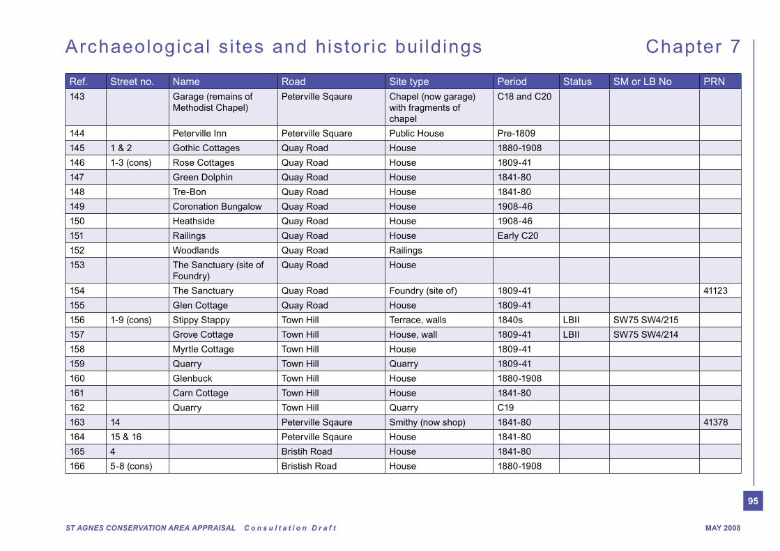
95
ST AGNES CONSERVATION AREA APPRAISAL C o n s u l t a t i o n D r a f t MAY 2008
Archaeological si tes and histor ic bui ldings Chapter 7
Ref. Street no. Name Road Site type Period Status SM or LB No PRN
143 Garage (remains of
Methodist Chapel)
Peterville Sqaure Chapel (now garage)
with fragments of
chapel
C18 and C20
144 Peterville Inn Peterville Square Public House Pre-1809
145 1 & 2 Gothic Cottages Quay Road House 1880-1908
146 1-3 (cons) Rose Cottages Quay Road House 1809-41
147 Green Dolphin Quay Road House 1841-80
148 Tre-Bon Quay Road House 1841-80
149 Coronation Bungalow Quay Road House 1908-46
150 Heathside Quay Road House 1908-46
151 Railings Quay Road House Early C20
152 Woodlands Quay Road Railings
153 The Sanctuary (site of
Foundry)
Quay Road House
154 The Sanctuary Quay Road Foundry (site of) 1809-41 41123
155 Glen Cottage Quay Road House 1809-41
156 1-9 (cons) Stippy Stappy Town Hill Terrace, walls 1840s LBII SW75 SW4/215
157 Grove Cottage Town Hill House, wall 1809-41 LBII SW75 SW4/214
158 Myrtle Cottage Town Hill House 1809-41
159 Quarry Town Hill Quarry 1809-41
160 Glenbuck Town Hill House 1880-1908
161 Carn Cottage Town Hill House 1841-80
162 Quarry Town Hill Quarry C19
163 14 Peterville Sqaure Smithy (now shop) 1841-80 41378
164 15 & 16 Peterville Sqaure House 1841-80
165 4 Bristih Road House 1841-80
166 5-8 (cons) Bristish Road House 1880-1908
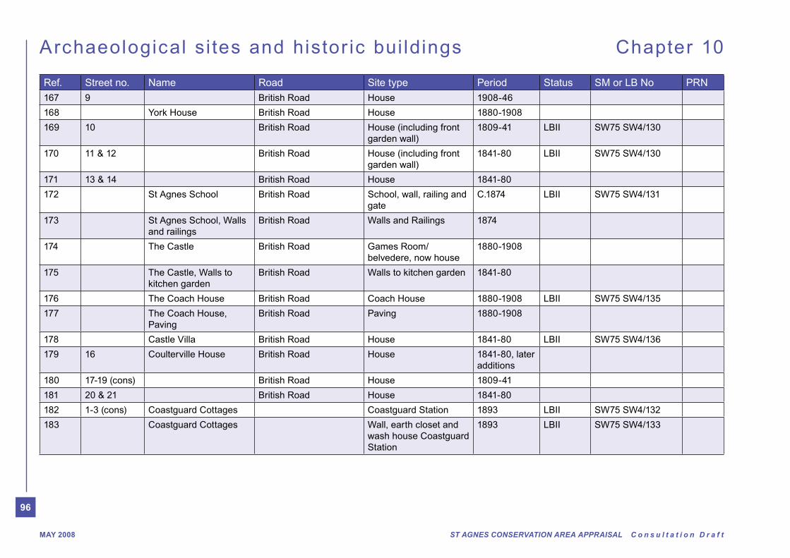
96
ST AGNES CONSERVATION AREA APPRAISAL C o n s u l t a t i o n D r a f tMAY 2008
Archaeological si tes and histor ic bui ldings Chapter 10
Ref. Street no. Name Road Site type Period Status SM or LB No PRN
167 9 British Road House 1908-46
168 York House British Road House 1880-1908
169 10 British Road House (including front
garden wall)
1809-41 LBII SW75 SW4/130
170 11 & 12 British Road House (including front
garden wall)
1841-80 LBII SW75 SW4/130
171 13 & 14 British Road House 1841-80
172 St Agnes School British Road School, wall, railing and
gate
C.1874 LBII SW75 SW4/131
173 St Agnes School, Walls
and railings
British Road Walls and Railings 1874
174 The Castle British Road Games Room/
belvedere, now house
1880-1908
175 The Castle, Walls to
kitchen garden
British Road Walls to kitchen garden 1841-80
176 The Coach House British Road Coach House 1880-1908 LBII SW75 SW4/135
177 The Coach House,
Paving
British Road Paving 1880-1908
178 Castle Villa British Road House 1841-80 LBII SW75 SW4/136
179 16 Coulterville House British Road House 1841-80, later
additions
180 17-19 (cons) British Road House 1809-41
181 20 & 21 British Road House 1841-80
182 1-3 (cons) Coastguard Cottages Coastguard Station 1893 LBII SW75 SW4/132
183 Coastguard Cottages Wall, earth closet and
wash house Coastguard
Station
1893 LBII SW75 SW4/133

97
ST AGNES CONSERVATION AREA APPRAISAL C o n s u l t a t i o n D r a f t MAY 2008
Archaeological si tes and histor ic bui ldings Chapter 10
Ref. Street no. Name Road Site type Period Status SM or LB No PRN
184 Coastguards Rocket
House
Rescue Equipment
House Coastguard
Station
1893 LBII SW75 SW4/134
185 23 British Road House 1841-80
186 British Road House 1809-41
187 26 British Road House 1880-1908
188 27 British Road House 1880-1908
189 Adj. 28 British Road Wall C19
190 28 British Road House 1809-41
191 War Memorial British Road War Memorial Early C20 LBII SW75 SW4/242
192 Methodist Chapel British Road Nonconformist chapel 1860 LBII SW75 SW2/241
193 Steps top Coastguard
Cottages
Town Hill Steps 1893
194 Town Hill Town Hill Embanked Road 1841-80
195 1-4 (cons) Houses 1908-46
196 Market House (site of) Churchtown Market House (site of) 1706-late C19 19431
197 41 & 41a Vicarage Road Shop 1809-41 LBII SW75 SW4/245
198 50 & 51 Vicarage Road Shop 1809-41
199 Wheal harriet (site of) British Road Mine (documentary) PM 41350
200 Boundary Stones Quay Road Boundary Stones C19
201 Milestone Penwinnick Road Milestone C19
202 Paving Churchtown Paving C18/C19
203 4 Outbuilding Trevaunanace Road Outbuilding 1841-80
204 Rosewood West Kitty House Pre-1809
205 House adj. The Ope Churchtown House 1809-41
206 Old Church Hall Churchtown Hall 1841-80
207 3 Churchtown Shop 1906-46
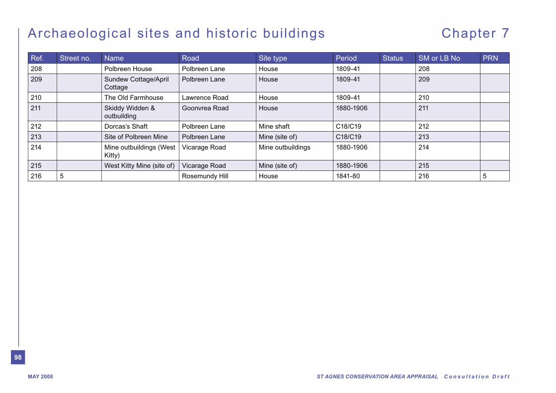
98
ST AGNES CONSERVATION AREA APPRAISAL C o n s u l t a t i o n D r a f tMAY 2008
Archaeological si tes and histor ic bui ldings Chapter 7
Ref. Street no. Name Road Site type Period Status SM or LB No PRN
208 Polbreen House Polbreen Lane House 1809-41 208
209 Sundew Cottage/April
Cottage
Polbreen Lane House 1809-41 209
210 The Old Farmhouse Lawrence Road House 1809-41 210
211 Skiddy Widden &
outbuilding
Goonvrea Road House 1880-1906 211
212 Dorcas’s Shaft Polbreen Lane Mine shaft C18/C19 212
213 Site of Polbreen Mine Polbreen Lane Mine (site of) C18/C19 213
214 Mine outbuildings (West
Kitty)
Vicarage Road Mine outbuildings 1880-1906 214
215 West Kitty Mine (site of) Vicarage Road Mine (site of) 1880-1906 215
216 5 Rosemundy Hill House 1841-80 216 5

99
ST AGNES CONSERVATION AREA APPRAISAL C o n s u l t a t i o n D r a f t MAY 2008
Fig. Page
Fig 1. Location of St Agnes. 10
Fig 2. Aerial photo of St Agnes. 10
Fig 3. View towards St Agnes Beacon. 11
Fig 4. View towards St Agnes Beacon. 11
Fig 5. Blue Hills seen from St Agnes Beacon
located above the cliffs seen in the background. 11
Fig 6. To the south of St Agnes, scattered mining
Fig 7. View towards Polberro and Wheal Coates
from St Agnes Beacon. 11
Fig 8. Former Hamlets. 12
Fig 9. Extract from ‘First Edition’ 1888 map of St Agnes. 14
Fig 10. Extract from ‘Second Edition’ 1908 map of St Agnes. 14
Fig 11. Historic development of the area. 15
Fig 12. 1925 view looking towards the Bakery, Churchtown. 18
Fig 13. Top of Town Hill back to Churchtown circa 1910. 18
Fig 14. 1924 view, No.6 Churchtown. 18
Fig 16. St Agnes Arts building in 1937 a Grocer and
Drapers shop. 18
Fig 17. The square at Churchtown around 1928. 18
Fig 18. British Road circa 1908. 19
Fig 19. Fore Street 1906 looking towards Churchtown. 19
Fig 20. Vicarage Road, St Agnes, around 1920. 19
Fig 21. Goonvrea Road 1905. 19
Fig 22. Vicarage Road, 1905. 19
Fig 23. Peterville around 1928. 19
Fig 24. Location of Wayside Cross and Bolsters Dyke. 20
Fig 25. Photograph of Cross at west end of St Agnes Church. 21
Fig 26. Churchtown/Historic centre. 24
Fig. Page
Fig 27. Churchtown terminating view. 24
Fig 28. Well maintained Victorian terrace, Vicarage Road. 24
Fig 29. St Agnes Church. 24
Fig 30. Strategic Views within and outside village 25
Fig 31. Stippy Stappy. 26
Fig 32. View from British Road towards open countryside. 26
Fig 33. View from rear of Churchtown towards Church spire. 26
Fig 34. View from Peterville towards Churchtown. 26
Fig 35. Form 30
Fig 36. Walled Front Garden. 35
Fig 37. Back Edge of Pavement. 35
Fig 38. Surviving cobbles outside the butchers shop. 38
Fig 39. Paving in alley between dwellings, Rosemundy Hill. 38
Fig 40. Typical random cobble detail. 38
Fig 41. Example of formal stone wall surrounding
domestic curtiage, British Road. 38
Fig 42. Milestone - Penwinnick Road. 38
Fig 43. Typical Colour Pallette for St Agnes
Fig 44. Aerial photo of St Agnes 44
Fig 45. Rear of properties on British Road treed hill. 44
Fig 46. Treed Cornish hedges along the Rosemundy
to Peterville Road. 44
Fig 47. St Agnes Garden of Rest. 44
Fig 48. Ornamental trees in St Agnes Cemetery. 44
Fig 49. Tree Preservation Orders 45
Fig 50. View towards Trevaunance Cove. 45
Fig 51. Polbreen Lane. 45
Fig 52. View towards Trevaunance Cove 45
Fig 53. View towards British Road - treed valley. 45

100
ST AGNES CONSERVATION AREA APPRAISAL C o n s u l t a t i o n D r a f tMAY 2008
Fig. Page
Fig 55. Character Areas 51
Fig 56. 52 & 53 Vicarage Road. 53
Fig 57. Miners & Mechanics Institute. 53
Fig 58. Good example of traditional shop frontage. 53
Fig 59. Cobbled alley leading to West Kitty. 53
Fig 60. Proliferation of signage. 55
Fig 61. Shop frontage could be improved. 55
Fig 62. Survival of traditional street furniture. 55
Fig 63. Railway Inn, Vicarage Road. 55
Fig 64. The Church Hall. 57
Fig 65. Rear of 52 & 53 Vicarage Road. 57
Fig 66. Attractive lychgate appearance to the
Garden of Rest. 57
Fig 67. Survival of traditional street furniture
- telephone box. 57
Fig 68. Opportunity for enhancement for entrance
into St Agnes. 60
Fig 69. Railway Inn, Vicarage Road. 60
Fig 70. 52 & 53 Vicarage Road. 60
Fig 71. Miners & Mechanics Institute. 60
Fig 72. 1 1-7 Peterville Square. 63
Fig 73. 2 Listed Buildings - 12 & 13 Peterville Square 63
Fig 74. 3 Proliferation of signage. 63
Fig 75. 4 Road dominated. 63
Fig 76. 5 Pair of attractive houses - 8 & 9 Peterville Square 63
Fig 77. 6 Ugly building - enhancement opportunity? 63
Fig 78. 7 Local street furniture could be updated. 63
Fig 79. 44 - 47 Rosemundy. 68
Fig 80. 7 Rosemundy large double fronted Victorian dwelling. 68
Fig 81. Walled alley between cottages. 68
Fig. Page
Fig 82. Victorian Artisans Cottages, 11, 12 and 14 Rosemundy. 68
Fig 83. Victorian terraced dwelling. 68
Fig 84. Former Methodist Chapel. 68
Fig 85. Rosemundy 68
Fig 86. 17 & 18 British Road Victorian Terrace. 71
Fig 87. 20 & 21 British Road, Large Victorian dwelling houses. 71
Fig 88. St Agnes School now converted to dwellings. 71
Fig 89. Granite stone boundary wall to Coulterville House. 71
Fig 90. 5 - 8 Victorian terraced dwellings. 71
Fig 91. Inappropriate style of lampstands. 71
Fig 92. Former Coach House. 71
Fig 93. 17 - 19 British Road. 71
Fig 94. Terrace of small cottages along Polbreen Lane. 76
Fig 95. Thatched cottage, Goonvrea Road. 76
Fig 96. Victorian Terrace, 65 & 66 Vicarage Road. 76
Fig 97. Good example of interwar bungalows, e.g. ‘Greencaps’. 76
Fig 99. Former Chapel now St Agnes Museum. 76
Fig 100. main access/entrance into village. 76
Fig 101. Opportunity for enhancement? 76
Fig 102. St Agnes Cemetery. 76
Fig 103. St Agnes workshop. 82
Fig 104. St Agnes workshop. 82
Fig 105. Walk around St Agnes - appraisal on foot. 82
Fig 106. Workshop. 82
Fig 106. Workshop. 82
Fig 108. Example of visual clutter - Peterville. 84
Fig 109. Narrow streets used by large vehicles. 84


