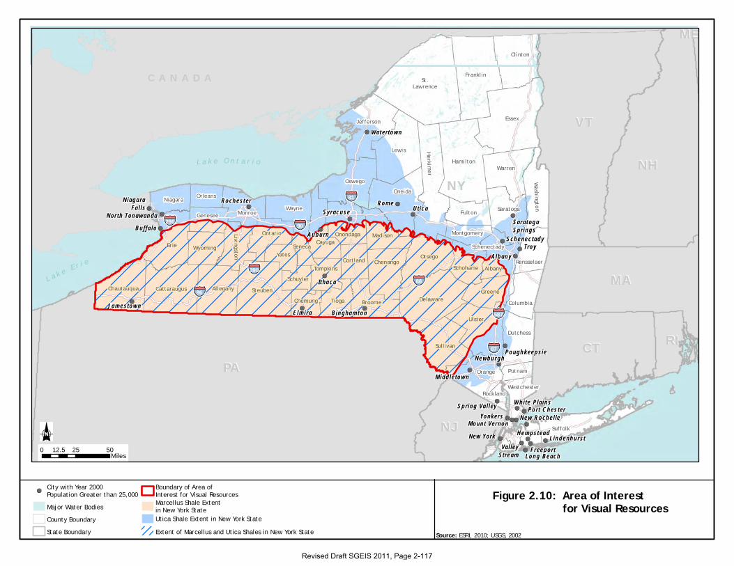
Revised Draft SGEIS 2011, Page 2-116
2.4.12 Visual Resources55
As stated in Section 1.3, oil and gas drilling is expected to occur statewide, with the exceptions of
(1) state-owned lands that constitute the Adirondack and Catskill Forest Preserves (the state
constitution requires that these areas remain forever wild and not be leased or sold), and (2) those
areas of the Adirondacks region, NYC, and Long Island where subsurface geology renders
drilling for hydrocarbons unlikely. No site-specific project locations are being evaluated in the
SGEIS; however, the Marcellus and Utica Shales are the most prominent shale formations in New
York State, and the prospective region for the extraction of natural gas from these formations
generally extends from Chautauqua County eastward to Greene, Ulster, and Sullivan Counties,
and from the Pennsylvania border north to the approximate location of the east-west portion of the
New York State Thruway between Schenectady and Auburn (Figure 2.10). This region covers all
or parts of 30 counties. Fourteen counties are located entirely within this area, and 16 counties
are located partially within the area.
For the purposes of impact analysis, visual resources located within the areas underlain by the
Marcellus and Utica Shales in New York may be considered representative of the types of visual
resources that would be encountered statewide. Therefore, this section describes the existing
federally and state-designated visual resources within the boundaries of this area in New York.
The potential for other visual resources and visually sensitive areas within the areas underlain by
the Marcellus and Utica Shales in New York, which are defined by regional planning entities,
county and town agencies, and local communities and their residents, is also acknowledged in this
section. All of these types of visual resources and visually sensitive areas (federal, state, and
local) also contribute to the „sense of place‟ that defines the character of a community, which is
discussed in Section 2.4.10.
55 Subsection 2.4.12, in its entirety, was provided by Ecology and Environment Engineering, P.C., August 2011 and was adapted
by the Department.
Figure 2.10: Area of Interest for Visual Resources
L a k e O n t a r i o
L a k e E r i e
Dutchess
Delaware
Cortland
ColumbiaGreene
Schenectady
Saratoga
SchoharieSchuyler
Seneca
Rockland
Erie
Chautauqua
Cayuga
Chenango
Chemung
Rensselaer
Broome
Albany
AlleganyCattaraugus
Westchester
WayneWashington
Warren
Ulster
Genesee
Montgomery
Monroe
MadisonLivingston YatesWyoming
Fulton
LewisHamilton
Herkimer
Jefferson
Orange
Orleans
Oswego
Otsego
Putnam
Tompkins
Sullivan
TiogaSteuben
Suffolk
Niagara
Onondaga
Oneida
Ontario
Clinton
Essex
St.Lawrence
Franklin
87
390
587
86
90290
88
81
NHNH
NJNJ
NYNY
PAPARIRI
VTVT
MAMA
CTCT
MEME
C A N A D A
Watertown
SaratogaSprings
Rome
Schenectady
Utica
TroyAlbany
SyracuseRochester
Auburn
NiagaraFalls
North Tonawanda
Ithaca
Buffa lo
Poughkeepsie
Binghamton
Newburgh
Elmira
Middletown
Spring Valley White PlainsPort Chester
New Rochelle
Jamestown
YonkersMount Vernon
LindenhurstHempstead
FreeportValleyStream
New York
Long Beach0 25 5012.5
Miles
Source: ESRI, 2010; USGS, 2002
Major Water Bodies
State Boundary Extent of Marcellus and Utica Shales in New York State
Boundary of Area ofInterest for Visual Resources
City with Year 2000Population Greater than 25,000
Utica Shale Extent in New York State
Marcellus Shale Extentin New York State
County Boundary
Revised Draft SGEIS 2011, Page 2-117
Revised Draft SGEIS 2011, Page 2-118
Criteria for identifying visual resources are defined in the Department‟s Program Policy DEP-00-
2, “Assessing and Mitigating Visual Impacts” (NYSDEC 2000). Federally designated visual
resources include, but are not limited to, National Historic Landmarks (NHL); properties listed in
the National Register of Historic Places (NRHP); National Natural Landmarks (NNL); National
Wildlife Refuges; National Parks, Recreation Areas, Seashores and Forests, as applicable;
National Wild and Scenic Rivers and American Heritage Rivers; and National Scenic, Historic
and Recreation Trails.
State-designated visual resources include, but are not limited to, properties listed or eligible for
listing in the State Register of Historic Places; Heritage Areas (formerly Urban Cultural Parks);
State Forest Preserves; State Game Refuges, State Wildlife Management Areas and Multiple Use
Areas; State Parks, Day Use Areas, Nature Preserves and Historic Preserves; State Wild, Scenic
and Recreational Rivers; State Scenic Byways, Parkways and Roads; State Conservation Areas
and other sites, areas, lakes, or reservoirs designated or eligible for designation as scenic in
accordance with ECL Article 49 or the DOT equivalent; Critical Environmental Areas; Scenic
Areas of Statewide Significance; State Trails; and Bond Act Properties purchased under the
Exceptional Scenic Beauty or Open Space Category. The New York Statewide Trails Plan, Open
Space Conservation Plan, and Statewide Comprehensive Outdoor Recreation Plan were also
consulted during the development of the existing environmental setting for visual resources
(OPRHP 2008, 2009, 2010).
Based on NYSDEC Program Policy DEP-00-2, the visual resources analysis for this draft SGEIS
includes the following:
The definitions of the specific visual resource or visually sensitive area, including
descriptions of relevant regulations, where appropriate.
The number of the specific visual resources or visually sensitive areas within the area
underlain by the Marcellus and Utica Shales in New York organized by county, where
appropriate.
Figures showing the locations of specific visual resources or visually sensitive areas
within the area underlain by the Marcellus and Utica Shales in New York.
Revised Draft SGEIS 2011, Page 2-119
Where appropriate, a table summarizing information for specific visual resources or
visually sensitive areas, generally focusing on visual, aesthetic, or scenic qualities of the
resource, if known, and organized by county.
2.4.12.1 Historic Properties and Cultural Resources
This section discusses historic properties and other cultural resources that are considered visual
resources per NYSDEC Program Policy DEP-00-2, including properties listed in the National and
State Registers of Historic Places (including National Historic Landmarks), state historic sites,
state historic parks, and state heritage areas (formerly urban cultural parks) (NYSDEC 2000).
Historic properties and cultural resources are often considered significant partly because of their
associated visual or aesthetic qualities. These visual or aesthetic qualities may be related to the
integrity of the appearance of these properties or resources, or to the integrity of their settings.
Viewsheds can also contribute to the significance of historic properties or cultural resources, and
viewsheds that contain historic properties and cultural resources may be considered significant
because of their presence in the landscape.
A property on or eligible for inclusion in the National or State Register of Historic Places (16
U.S.C. §470a et seq., Parks, Recreation and Historic Preservation Law Section 14.07)
Historic properties are defined as those properties that have been listed in, or determined eligible
for listing in, the NRHP (Advisory Council on Historic Preservation 2011). The NRHP, which is
the official list of the nation‟s historic places worthy of preservation, was established under the
National Historic Preservation Act of 1966, as amended (NPS 2011a; OPRHP 2011a). In general,
historic properties are 50 years old or older, and they retain much of their original appearance
because of the integrity of their location, design, setting, materials, workmanship, feeling, and
association (OPRHP 2011a).
The National Park Service (NPS) maintains a database of properties listed in the NRHP. (This
database does not include information for other properties determined to be eligible for listing in
the NRHP.) At least 1,050 NRHP-listed properties have been identified within the area underlain
by the Marcellus and Utica Shales in New York (Table 2.92) (NPS 2011b, ESRI 2011). The
significance of properties listed or eligible for listing on the NRHP may be derived in varying
degrees from scenic or aesthetic qualities that may be considered visually sensitive.
Revised Draft SGEIS 2011, Page 2-120
Table 2.92 - Number of NRHP-Listed Historic Properties within the Area Underlain by
the Marcellus and Utica Shales in New York (New August 2011)
County Name
Number of NRHP-listed
Historic Properties within
Entire County
Albany* 7
Allegany 27
Broome 52
Cattaraugus 26
Cayuga* 44
Chautauqua 45
Chemung 32
Chenango 39
Cortland 25
Delaware 62
Erie* 28
Genesee* 6
Greene* 45
Livingston* 74
Madison* 48
Oneida* 2
Onondaga* 18
Ontario* 37
Orange* 3
Otsego* 53
Schoharie* 15
Schuyler 14
Seneca* 10
Steuben 49
Sullivan* 64
Tioga 53
Tompkins 57
Ulster* 32
Wyoming 18
Yates 65
Total 1,050 Sources: NPS 2011b; ESRI 2010.
* Only a portion of the county is located within the area underlain by the Marcellus and Utica
Shales in New York.
The State Register of Historic Places, which is the official list of New York State‟s historic places
worthy of preservation, was established under the New York State Historic Preservation act of
1980. The eligibility criteria for properties listed in the State Register of Historic Places are the
same as the eligibility criteria for the NRHP (OPRHP 2011a). The OPRHP maintains the
database of records for properties listed in, or determined eligible for listing in, the State and
Revised Draft SGEIS 2011, Page 2-121
National Registers of Historic Places (OPRHP 2011b). Over 250,000 properties located across
New York State are included in this database, and the database provides information on whether
the properties have been evaluated for State and/or National Register eligibility, and if evaluated,
the eligibility status of the resource (OPRHP 2011c). The significance of properties listed or
eligible for listing in the State Register of Historic Places may be derived in varying degrees from
scenic or aesthetic qualities that may be considered visually sensitive.
National Heritage Areas
National Heritage Areas (NHAs) are designated by Congress. For an area to be considered for
designation, certain key elements must be present. Of primary importance, the landscape must
have nationally distinctive natural, cultural, historic, and scenic resources that, when linked
together, tell a unique story about the nation. NHAs are not units of the NPS, nor are they owned
or managed by the NPS. Each NHA is governed by separate authorizing legislation and operates
under provisions unique to its resources and desired goals. The heritage area concept offers an
innovative method for citizens, in partnership with local, state, and federal governments and
nonprofit and private sector interests, to shape the long-term future of their communities (NPS
2010d, 2011g).
Two NHAs are located partially within the area underlain by the Marcellus and Utica Shales in
New York (Figure 2.11): portions of the Erie Canalway National Heritage Corridor in Erie,
Ontario, Yates, Seneca, Cayuga, Schuyler, and Tompkins Counties; and portions of the Hudson
River Valley NHA in Albany, Greene, Ulster, and Sullivan Counties (OPRHP 2007; NPS 2010d,
2011e; Erie Canalway National Heritage Corridor 2008; Hudson River Valley National Heritage
Corridor 2011). These NHAs are likely to contain scenic or aesthetic areas that may be
considered visual resources or visually sensitive.
Properties Designated as National Historic Landmarks
National Historic Landmarks (NHLs) are nationally significant historic places designated by the
Secretary of the Interior because they possess exceptional value or quality in illustrating or
interpreting the heritage of the United States (NPS 2011c). There are 19 NHLs located within the
area underlain by the Marcellus and Utica Shales in New York (Table 2.93 and Figure 2.11).
Generally, these NHLs are historic buildings (residences, churches, civic buildings, and
Revised Draft SGEIS 2011, Page 2-122
institutional buildings), but other types of historic properties are also represented, including
battlefields and canals (Table 2.93). The significance of NHL-designated properties may be
derived in varying degrees from scenic or aesthetic qualities that may be considered visual
resources or visually sensitive.
State Historic Sites and Historic Parks
State Historic Sites and State Historic Parks are historic and cultural places that tell the story of
the New York State‟s rich heritage. Owned by New York State, these places are preserved and
interpreted for the public‟s enjoyment, education, and enrichment (OPRHP 2011d). There are 12
State Historic Sites and two State Historic Parks in the counties located entirely or partially within
the area underlain by the Marcellus and Utica Shales in New York (OPRHP 2008). Of these 14
historic and cultural places, only two are within the area underlain by the Marcellus and Utica
Shales in New York: Genesee Valley Canal State Historic Site in Livingston County and Lorenzo
State Historic Site in Madison County (see Figure 2.11) (OPRHP 2011d). State Historic Sites and
State Historic Parks may contain scenic or aesthetic qualities that may be considered visually
sensitive.
Local Visually Sensitive Resources or Areas
The counties that are entirely or partially located within the area underlain by the Marcellus and
Utica Shales in New York are expected to contain numerous other local visual resources or
visually sensitive areas. These local visual resources or visually sensitive areas would be
identified, defined and/or designated by regional planning entities and local (county and town)
communities and their residents and would be in addition to the visual resources or visually
sensitive areas described above that are defined or designated by federal and state agencies and
guidance.
Revised Draft SGEIS 2011, Page 2-123
Table 2.93 - National Historic Landmarks (NHLs) Located within the Area Underlain by
the Marcellus and Utica Shales in New York (New August 2011)
County Name*
Number of NHLs
within County
Names of NHLs
Broome 1 New York State Inebriate Asylum
Cayuga** 6 William H. Seward House
Harriet Tubman Home for the Aged
Harriet Tubman Residence
Thompson A.M.E. Zion Church
Willard Memorial Chapel-Welch
Memorial Hall
Jethro Wood House
Chautauqua 2 Chautauqua Historic District
Lewis Miller Cottage, Chautauqua
Institute
Chemung 1 Newton Battlefield
Delaware 1 John Burroughs Memorial (Woodchuck
Lodge)
Erie** 2 Millard Fillmore House
Roycroft Campus
Madison** 1 Gerrit Smith Estate
Orange** 1 Delaware and Hudson Canal***
Otsego** 1 Hyde Hall
Seneca** 1 Rose Hill
Sullivan** 1 Delaware and Hudson Canal***
Tompkins 1 Morrill Hall, Cornell University
Ulster** 2 John Burroughs Riverby Study
Delaware and Hudson Canal***
Total 19 Sources: ESRI 2010; NPS 2011d; OPRHP 2008.
* There are no NHLs within other counties located entirely or partially within the area underlain by the Marcellus and Utica
Shales in New York.
** Only a portion of the county is located within the area underlain by the Marcellus and Utica Shales in New York.
*** The Delaware and Hudson Canal NHL traverses portions of three counties (Orange, Sullivan, and Ulster).
Revised Draft SGEIS 2011, Page 2-124
State Heritage Areas (former Urban Cultural Parks [Parks, Recreation and Historic Preservation
Law Section 35.15])
The State Heritage Area System, formerly known as the Urban Cultural Park System, is a state
and local partnership established to preserve and develop areas that have special significance to
New York State (OPRHP 2011e). New York State Heritage Areas are places where unique
qualities of geography, history, and culture create a distinctive identity that becomes the focus of
four heritage goals: preservation of significant resources; education that interprets lessons from
the past; recreation and leisure activities; and economic revitalization for sustainable communities
(OPRHP 2011f). Four regional or urban heritage areas or corridors are located entirely or
partially within the area underlain by the Marcellus and Utica Shales in New York (Figure 2.11):
the Concord Grape Belt (Lake Erie) Heritage Area in Chautauqua and Cattaraugus Counties;
portion of the Western Erie Canal Heritage Area in southern Erie County; portions of the
Mohawk Valley Heritage Area in Oneida, Schoharie, and Albany Counties; and the Susquehanna
Heritage Area in Broome County (OPRHP 2007, 2011e; 2011f; Concord Grape Belt Heritage
Association 2011; Western Erie Canal Alliance 2010-2011). These State Heritage Areas are
likely to contain scenic or aesthetic areas that may be considered visual resources or visually
sensitive.
Figure 2.11: Visually Sensitive Areas Associated with Historic Properties and Cultural Resources
Major Water BodiesCounty BoundaryState BoundaryBoundary of Area ofInterest for Visual Resources
Erie Canalway NHAHudson River Valley NHAState Urban Hertage Area
State Regional Heritage AreaWestern Erie CanalConcord Grape BeltMohawk ValleyNorth Shore
National Register ofHistoric Places SiteNational Historic LandmarkState Historic Site
L a k e O n t a r i o
L a k e E r i e
WesternErie Canal
Michigan Street
Buffalo Theatre District
Susquehanna
MohawkValley
Concord Grape Belt
NorthShore
Dutchess
Delaware
Cortland
ColumbiaGreene
Schenectady
Saratoga
SchoharieSchuyler
Seneca
Rockland
Erie
Chautauqua
Cayuga
Chenango
Chemung
Rensselaer
Broome
Albany
AlleganyCattaraugus
Westchester
WayneWashington
Warren
Ulster
GeneseeMontgomery
Monroe
Madison
Livingston YatesWyoming
Fulton
LewisHamilton
Herkimer
Jefferson
Orange
OrleansOswego
Otsego
Putnam
Tompkins
Sullivan
TiogaSteuben
Suffolk
Niagara
Onondaga
Oneida
Ontario
Clinton
Essex
St.Lawrence
Franklin
87
390
58786
90290
88
81
NHNH
NJNJ
NYNY
PAPARIRI
VTVT
MAMA
CTCT
C A N A D A
Albany
Kingston
Whitehall
SacketsHarbor
SyracuseSchenectady
Seneca Falls
Saratoga
Rochester
HarborPark
Niagara FallsUnderground
Railroad
RiverSparkWestern
Erie Canal
0 25 5012.5Miles
Hudson River Valley National Heritage Area
Erie Canalway National Heritage Corridor
Source: ESRI, 2010; USGS, 2002; OPRHP, 2007, 2009, 2011;NYCSCIC, 2005; NPS, 2007
Revised Draft SGEIS 2011, Page 2-125
Revised Draft SGEIS 2011, Page 2-126
2.4.12.2 Parks and Other Recreation Areas
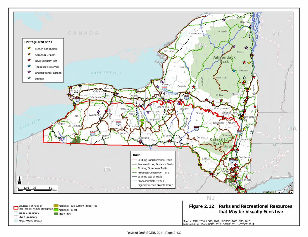
This section discusses parks and other recreation areas that are considered visual resources per
NYSDEC Program Policy DEP-00-2, “Assessing and Mitigating Visual Impacts,” including state
parks; properties included in the National Park System and areas defined as national recreation
areas, seashores and forests; and state or federally designated trails (NYSDEC 2000). These
recreation areas often contain scenic areas and/or are developed partly because of their associated
visual or aesthetic qualities.
State Parks [Parks, Recreation and Historic Preservation Law Section 14.07]
State Parks contain natural, historic, cultural, and/or recreational resources of significance to New
York State. (Note that State Historic Parks are discussed separately in Section 2.4.12.1). Owned
by New York State, these parks are maintained for the public‟s use. Thirty-four state parks are
located partially or entirely within the area underlain by the Marcellus and Utica Shales in New
York (Table 2.94 and Figure 2.12) (OPRHP 2008). These parks may contain scenic or aesthetic
areas that may be considered visual resources or visually sensitive.
Revised Draft SGEIS 2011, Page 2-127
Table 2.94 - State Parks Located within the Area Underlain by the Marcellus and Utica Shales in New York (New August 2011)
County
Name*
Number of State
Parks within County Names of State Parks within County
Albany** 1 John Boyd Thacher State Park
Broome 2 Chenango Valley State Park
Oquaga Creek State Park
Cattaraugus 1 Allegany State Park
Cayuga** 2 Fillmore Glen State Park
Long Point State Park
Chautauqua 2 Lake Erie State Park
Long Point on Lake Chautauqua State Park
Chemung 1 Mark Twain State Park
Chenango 2 Hunts Pond State Park
Bowman Lake State Park
Delaware 1 Oquaga Creek State Park
Erie** 3 Evangola State Park
Woodlawn Beach State Park
Knox Farm State Park
Genesee** 1 Darien Lakes State Park
Livingston** 1 Letchworth State Park
Madison** 2 Chittenango Falls State Park
Helen L McNitt State Park (undeveloped)
Otsego** 3 Gilbert Lake State Park
Betty and Wilbur Davis State Park
Glimmerglass State Park
Schoharie** 2 Max V. Shaul State Park
Mine Kill State Park
Schuyler 1 Watkins Glen State Park
Seneca** 3 Seneca Lake State Park
Sampson State Park
Taughannock Falls State Park
Steuben 2 Stony Brook State Park
Pinnacle State Park
Sullivan** 1 Lake Superior State Park
Tompkins 3 Taughannock Falls State Park
Robert H. Treman State Park
Buttermilk Falls State Park
Wyoming 2 Letchworth State Park
Silver Lake State Park (undeveloped)
Yates 1 Keuka Lake State Park
Total 34*** Sources: ESRI 2010; OPRHP 2008.
* No state parks within other counties entirely or partially within the area underlain by the Marcellus and Utica Shales in NYS.
** Only a portion of the county is located within the area underlain by the Marcellus and Utica Shales in New York.
***Letchworth State Park is in two counties (Wyoming and Livingston); Oquaga Creek State Park is in two counties (Broome and
Delaware); Taughannock Falls State Park is in two counties (Seneca and Tompkins).
Revised Draft SGEIS 2011, Page 2-128
The National Park System, Recreation Areas, Seashores, Forests (16 U.S.C. 1c)
Properties included in the National Park System and areas defined as National Recreation Areas,
Seashores and Forests contain natural, historic, cultural, and recreational resources of significance
to the nation. Owned by the U.S. government and operated by various federal agencies, they are
maintained for the public‟s use. At least five properties included in the National Park System are
located in counties that are partially or entirely within the area underlain by the Marcellus and
Utica Shales in New York: Women‟s Rights National Historic Park in Seneca County; Fort
Stanwix National Monument in Oneida County; the North Country National Scenic Trail, which
traverses New York State; Old Blenheim Covered Bridge in Schoharie County; and the Upper
Delaware Scenic & Recreational River in Orange, Sullivan, and Delaware Counties (OPRHP
2008). One National Forest, the Finger Lakes National Forest in Seneca and Schuyler Counties,
is located within the area underlain by the Marcellus and Utica Shales in New York (Figure 2.12)
(OPRHP 2008). No National Recreation Areas or National Seashores are located within the area
underlain by the Marcellus and Utica Shales in New York (OPRHP 2008). The federally-owned
National Park System properties and the National Forest may contain scenic or aesthetic areas
that may be considered visual resources or visually sensitive.
A state or federally designated trail, or one proposed for designation (16 U.S.C. Chapter 27 or
equivalent)
New York State‟s natural and cultural resources provide for a broad range of land and water-
based trails that offer multiple recreational experiences (Table 2.95). Each region of the state
offers a unique setting and different opportunities for trails (OPRHP 2008). New York State
breaks the existing system of trails into three general categories: primary trails that are of
national, statewide, or regional significance and that are considered long-distance trails;
secondary trails, which typically connect to a primary trail system but are generally within parks
or open space areas; and stand-alone trails, which are trails of local significance that do not
connect to a primary trail system. Stand-alone trails are generally loop trails, trails that connect to
points of interest, or trails that provide short connections between parks, open spaces, historic
sites and/or communities, or elements of a community (OPRHP 2008).
Revised Draft SGEIS 2011, Page 2-129
Additional state-designated trails include heritage trails, greenway trails, and/or water trails.
Heritage trails are existing non-linear resources associated with historical movements or themes
(OPRHP 2007, 2010). Greenway trails are existing and proposed multi-use trails located within
linear corridors of open space that connect public places, connect people with nature, and protect
areas for environmentally sustainable purposes that include recreation, conservation, and
transportation (OPRHP 2007, 2010). Water trails, also known as blueways, are existing and
proposed designated recreational water routes suitable for canoes, kayaks, and small motorized
watercraft (OPRHP 2010).
One federally recognized trail, the North Country National Scenic Trail, traverses portions of the
area underlain by the Marcellus and Utica Shales in New York. The North Country National
Scenic Trail, an approximately 3,200-mile-long trail extending from eastern New York State to
North Dakota, is administered by the NPS (NPS 2010a, 2010b). The portion of the trail in New
York is included in the system of trails shown on Figure 2.12. National Scenic Trails are
designated under Section 5 of the National Trails System Act and are defined as extended trails
located to provide for maximum outdoor recreation potential and for the conservation and
enjoyment of the nationally significant scenic, historic, natural, or cultural qualities of the areas
though which they pass (NPS 2010a). A number of these types of trails are shown on Figure
2.12. All of these types of trails are likely to contain scenic or aesthetic areas that may be
considered visual resources or visually sensitive
Figure 2.12: Parks and Recreational Resources that May be Visually Sensitive
Boundary of Area ofInterest for Visual ResourcesCounty BoundaryState BoundaryMajor Water Bodies
National Park System PropertiesNational ForestState Park
L a k e O n t a r i o
L a k e E r i e
Dutchess
Delaware
Cortland
ColumbiaGreene
Schenectady
Saratoga
SchoharieSchuyler
Seneca
Rockland
Erie
Chautauqua
Cayuga
Chen
ango
Chemung
Rensselaer
Broome
Albany
Allegany
Cattaraugus
Westchester
Wayne
Washington
Warren
Ulster
Genesee
Montgomery
Monroe
Madison
Livingston
YatesWyoming
Fulton
Lewis
Hamilton
Herkimer
Jefferson
Orange
Orleans
Oswego
Otsego
Putnam
Tompkins
Sullivan
Tioga
Steuben
Suffolk
Niagara
Onondaga
Oneida
Ontario
Clinton
Essex
St.Lawrence Franklin
87
390
58786
90290
88
81
NHNH
NJNJ
NYNY
PAPARIRI
VTVT
MAMA
CTCT
C A N A D A
AdirondackPark
Cat sk i l lPa rk
0 25 5012.5Miles
Source: ESRI, 2010; USGS, 2002; NYCSCIC, 2005; NPS, 2010;National Atlas US and USGS, 2010; OPRHP, 2011; NYSDOT, 2011
Heritage Trail SitesFrench and IndianAbraham LincolnRevolutionary WarTheodore RooseveltUnderground RailroadWomen
TrailsExisting Long Distance TrailsProposed Long Distance TrailsExisting Greenway TrailsProposed Greenway TrailsExisting Water TrailsProposed Water TrailsSigned On-road Bicycle Route
Revised Draft SGEIS 2011, Page 2-130
Revised Draft SGEIS 2011, Page 2-131
Table 2.95 - Select Trails Located within the Area Underlain by the Marcellus and Utica Shales in New York (New August 2011)
Name of Trail Type of Trail
North County National Scenic Trail* Long-distance trail of national significance
Long Path* Long-distance trail of statewide significance
Finger Lakes Trail* Long-distance trail of statewide significance
Canalway Trail* Long-distance trail of statewide significance
Hudson River Valley Greenway Trail System* Long-distance trail of statewide significance
Hudson River Greenway Water Trail* Long-distance trail of statewide significance
Genesee Valley Greenway* Long-distance trail of statewide significance
The statewide Snowmobile Trail System* Long-distance trail of statewide significance
Conservation Trail* Long-distance hiking trail of regional significance
Letchworth Trail* Long-distance hiking trail of regional significance
Bristol Hills Trail* Long-distance hiking trail of regional significance
Link Trail* Long-distance hiking trail of regional significance
Shawangunk Ridge Trail Long-distance hiking trail of regional significance
Abraham Lincoln Heritage Trail State-designated Heritage Trail consisting of resources in Chautauqua,
Onondaga, and Albany Counties
Women Heritage Trail State-designated Heritage Trail consisting of resources in Chautauqua,
Wyoming, Ontario, Seneca, and Cayuga Counties
Underground Railroad Heritage Trail State-designated Heritage Trail consisting of resources in Wyoming,
Chemung, Seneca, Cayuga, Onondaga, and Madison Counties
Revolutionary War Heritage Trail State-designated Heritage Trail consisting of resources in Chemung, Broome
Madison, Otsego Schoharie, Sullivan and Orange Counties
French and Indian Heritage Trail State-designated Heritage Trail consisting of resources in Sullivan County
Catherine Valley Trail Multi-use trail located within linear corridors of open space in Chemung and
Schuyler Counties
Catskill Scenic Trail Multi-use trail located within linear corridors of open space in Delaware
County
Delaware & Hudson Canal Trail Multi-use trail located within linear corridors of open space in Sullivan and
Ulster Counties
Erie Canalway Trail* Multi-use trail located within linear corridors of open space
Genesee Valley Greenway* Multi-use trail located within linear corridors of open space
Ontario Pathways Rail Trail Multi-use trail located within linear corridors of open space in Ontario
County
Orange Heritage Trail Multi-use trail located within linear corridors of open space in Orange County
Pat McGee Trail Multi-use trail located within linear corridors of open space in Cattaraugus
County
Wallkill Valley Rail Trail Multi-use trail located within linear corridors of open space in Ulster County
Marden Cobb Waterway Trail Recreational water route
Cayuga-Seneca Canal Trail, which is a component
of the larger NYS Canalway Water Trail* Recreational water route
Chemung Basin River Trail* Recreational water route
Headwaters River Trail(s)* Recreational water route
Upper Delaware Scenic and Recreational River* Recreational water route
Proposed Triple Divide Water Trail* Proposed recreational water route
Sources: ESRI 2010; OPRHP 2007, 2010; NPS 2010a, 2010b.
* Trail traverses one or more counties
Revised Draft SGEIS 2011, Page 2-132
2.4.12.3 Natural Areas
This section discusses natural areas that are considered visual resources per NYSDEC Program Policy
DEP-00-2, including state forest preserve areas; state nature and historic preserves; state or national wild,
scenic and recreational rivers (designated and potential); national wildlife refuges, state game refuges, and
state wildlife management areas; and national natural landmarks (NYSDEC 2000). These natural areas
often contain scenic areas and/or are developed partly because of their associated visual or aesthetic
qualities.
The State Forest Preserve (NYS Constitution Article XIV)
The State Forest Preserve consists of lands included in the Adirondack Forest Preserve (approximately 2.6
million acres) and the Catskill Forest Preserve (approximately 290,000 acres). These lands, which
represent the majority of all state-owned property within the Adirondack and Catskill Parks, are protected
as “forever wild” under Article XIV of the New York State Constitution. They are recognized as having
exceptional scenic, recreational, and ecological value (NYSDEC 2011a, 2011b, 2011c).
The Adirondack Forest Preserve, located entirely within the Adirondack Park boundaries, is outside the
area underlain by the Marcellus and Utica Shales in New York. The Catskill Forest Preserve, located
entirely within the Catskill Park boundaries, is located within the eastern part of this area in portions of
Delaware, Greene, Ulster, and Sullivan Counties (Figure 2.12). Lands included in the Catskill Forest
Preserve are likely to contain scenic or aesthetic areas that may be considered visual resources or visually
sensitive.
State Nature and Historic Preserves (Section 4 of Article XIV of State Constitution)
State nature and historic preserves are parcels of land owned by the state that were acquired to protect the
biological diversity of plants, animals, and natural communities, and which may provide a field laboratory
for the observation of and education in these relationships. These areas may also provide for the protection
of places of historical and natural interest, and may be used by the public for passive recreational pursuits
that are compatible with protection of the ecological significance, historic features, and/or natural character
of the areas designated as state nature and historic preserves (NYSDEC 2011d).
Eight state nature and historic preserves are located in the counties within the area underlain by the
Marcellus and Utica Shales in New York (Table 2.96). These state nature and historic preserves may
contain scenic or aesthetic areas that may be considered visual resources or visually sensitive.
Figure 2.13: Natural Areas that May be Visually Sensitive
Major Water BodiesCounty BoundaryState BoundaryBoundary of Area ofInterest for Visual Resources
National Natural LandmarkNational Wild and Scenic River
National Wildlife RefugeState Forest PreserveState Unique AreaState Wildlife Management Area
L a k e O n t a r i o
L a k e E r i e
Dutchess
Delaware
Cortland
ColumbiaGreene
Schenectady
Saratoga
SchoharieSchuyler
Seneca
Rockland
Erie
Chautauqua
Cayuga
Chenango
Chemung
Rensselaer
Broome
Albany
AlleganyCattaraugus
Westchester
Wayne
Washington
Warren
Ulster
GeneseeMontgomery
Monroe
MadisonLivingston YatesWyoming
Fulton
LewisHamilton
Herkimer
Jefferson
Orange
Orleans
Oswego
Otsego
Putnam
Tompkins
Sullivan
TiogaSteuben
Suffolk
Niagara
Onondaga
Oneida
Ontario
Clinton
Essex
St.Lawrence
Franklin
87
390
58786
90290
88
81
NHNH
NJNJ
NYNY
PAPARIRI
VTVT
MAMA
CTCT
C A N A D A
0 25 5012.5Miles
Source: ESRI, 2010; USGS, 2002; NYDEC, 2010; NPS, 2011;National Atlas US and USGS, 2010
Revised Draft SGEIS 2011, Page 2-133
Revised Draft SGEIS 2011, Page 2-134
Table 2.96 - State Nature and Historic Preserves in Counties Located within the Area
Underlain by the Marcellus and Utica Shales in New York (New August 2011)
County Name*
Number of State
Nature and
Historic Preserves
within County
Names of State Nature
and Historic Preserves
Allegany 1 Showy Lady Slipper Parcel (Town of New Hudson)
Cattaraugus 1 Zoar Valley Unique Area (Towns of Otto and Persia)
Cortland 2 Bog Brook (Towns of Southeast and Patterson)
Labrador Hollow (Town of Truxton)
Erie** 2 Reinstein Woods (Town of Cheektowaga)
Zoar Valley Unique Area (Town of Collins)
Onondaga** 1 Labrador Hollow (Town of Fabius)
Ontario** 1 Squaw Island (Town of Canandaigua)
Yates 2 Parish Gully (Town of Italy)
Clark Gully (Towns of Middlesex and Italy)
Total 8***
Sources: ESRI 2010; OPRHP 2008; NYSDEC 2011d.
* There are no State Nature and Historic Preserves within other counties located entirely or partially within the area underlain
by the Marcellus and Utica Shales in New York.
** Only a portion of the county is located within the area underlain by the Marcellus and Utica Shales in New York.
*** Labrador Hollow is in two counties (Onondaga and Cortland); Zoar Valley Unique Area is in two counties (Cattaraugus and
Erie).
Rivers designated as National or State Wild, Scenic or Recreational (16 U.S.C. Chapter 28, ECL
15-2701 et seq.)
National Wild, Scenic or Recreational Rivers are those rivers designated by Congress or the
Secretary of the Interior in accordance with the Wild and Scenic Rivers Act of 1968. The purpose
of such designation is to preserve those rivers with outstanding natural, cultural, and recreational
values in a free-flowing condition for the enjoyment of present and future generations. Wild
rivers are those rivers or sections of rivers that are free of impoundments and generally
inaccessible except by trail, with watershed or shorelines essentially primitive and waters
unpolluted. These represent vestiges of primitive America. Scenic rivers are those rivers or
sections of rivers that are free of impoundments, with shorelines or a watershed still largely
primitive and shorelines largely undeveloped, but accessible in places by roads. Recreational
rivers are those rivers or sections of rivers that are readily accessible by road or railroad, that may
have some development along their shorelines, and that may have undergone some impoundment
or diversion in the past (National Wild and Scenic Rivers System 2011a).
Revised Draft SGEIS 2011, Page 2-135
A portion of only one river, the Delaware River (also known as the Upper Delaware Scenic and
Recreational River), has been designated a National Wild and Scenic River in New York State
(National Wild and Scenic Rivers System 2011b, 2011c; NPS 2010c). This portion of the
Delaware River, located in Delaware County along the New York-Pennsylvania border, is within
the area underlain by the Marcellus and Utica Shales in New York (see Table 2.97 and Figure
2.13). Designated in part for its scenic qualities, this portion of the Delaware River contains
scenic areas that may be considered visual resources or visually sensitive.
A portion of one other water body in New York State, the East Branch of Fish Creek, located in
Lewis County, was studied for its potential for inclusion in the National Wild and Scenic Rivers
System (National Wild and Scenic Rivers System 2011d). This portion of Fish Creek is located
in Oneida County, which is partially located within the area underlain by the Marcellus and Utica
Shales in New York (Table 2.97).
Section 5(d) of the National Wild and Scenic Rivers Act of 1968 requires federal agencies to
consider the effects of planned use and development on potential national wild and scenic river
areas. In partial fulfillment of this requirement, the NPS has compiled and maintains a
Nationwide Rivers Inventory (NRI), which is a register of river segments that potentially qualify
as National Wild, Scenic or Recreational River areas (NPS 2008a).
In order to be listed on the NRI, a river must be free-flowing and possess one or more
Outstanding Remarkable Values (ORVs). In order to be assessed as outstandingly remarkable, a
river-related value must be a unique, rare, or exemplary feature that is significant at a comparative
regional or national scale. Such values must be directly river-related: located in the river or on its
immediate shorelands (generally within 0.25 mile on either side of the river); contribute
substantially to the function of the river ecosystem; and/or owe their location or existence to the
presence of the river. ORVs may involve values associated with scenery, recreation, geology,
fish, wildlife, prehistory, history, cultural, or other values (e.g., hydrology, paleontology, or
botany resources) (NPS 2008a).
Revised Draft SGEIS 2011, Page 2-136
Portions of 17 NRI-listed rivers or water bodies are located partially or entirely within the area
underlain by the Marcellus and Utica Shales in New York (Table 2.97). Many of these rivers or
water bodies have been designated in part for their scenic qualities, and all of these rivers or water
bodies may contain scenic areas that may be considered visual resources or visually sensitive.
State-designated Wild, Scenic and Recreational Rivers are those rivers or portions of rivers of the
state of New York protected by the state‟s Wild Scenic and Recreational Rivers Act. This act
protects those rivers of the state that possess outstanding scenic, ecological, recreational, historic,
and scientific values. Attributes of these rivers may include value derived from fish and wildlife
and botanical resources, aesthetic quality, archaeological significance, and other cultural and
historic features. State policy is to preserve designated rivers in a free-flowing condition,
protecting them from improvident development and use, and to preserve the enjoyment and
benefits derived from these rivers for present and future generations (NYSDEC 2011e).
Portions of two state-designated Wild, Scenic and Recreational Rivers - the Genesee River and
the Upper Delaware River - flow within counties located partially or entirely within the area
underlain by the Marcellus and Utica Shales in New York (Table 2.97). These rivers have been
designated, in part, for their scenic qualities, and both of these rivers may contain scenic areas that
may be considered visual resources or visually sensitive.
Revised Draft SGEIS 2011, Page 2-137
Table 2.97 - National and State Wild, Scenic and Recreational Rivers (designated or potential) Located
within the Area Underlain by the Marcellus and Utica Shales in New York (New August 2011)
County Name* Name of River or Water Body Designation Status
Albany** Portion of Catskill Creek*** Listed in NRI in 1982
Allegany Portions of Genesee River*** Listed in NRI in 1982; updated in 1995
Designated a State Wild, Scenic and
Recreational River
Cattaraugus Portions of Allegheny River
Portions of Cattaraugus Creek***
Portion of Conewango Creek ***
Listed in NRI in 1982, updated in 1995
Listed in NRI in 1982; updated in 1995
Listed in NRI in 1982
Cayuga** Portion of Fall Creek*** Designated a State Wild, Scenic and
Recreational River
Chautauqua Portion of Cattaraugus Creek***
Portion of Chautauqua Creek
Portion of Conewango Creek***
Listed in NRI in 1982; updated in 1995
Listed in 1982
Listed in NRI in 1982
Chemung Portion of Chemung River Listed in NRI in 1982
Delaware Delaware River (Upper)***
Portions of Delaware River, East Branch
Designated a National Wild & Scenic
River in 1978
Listed in NRI in 1982 and 1995
Erie** Portions of Cattaraugus Creek*** Listed in NRI in 1982; updated in 1995
Greene** Portion of Batavia Kill Listed in NRI in 1982
Livingston** Portions of Genesee River*** Listed in NRI in 1982; updated in 1995
Designated a State Wild, Scenic and
Recreational River
Orange** Portion of Basher Kill *** Listed in NRI in 1995
Steuben Portion of Canisteo River
Portion of Cohocton River
Listed in NRI in 1995
Sullivan** Delaware River (Upper)***
Portion of Basher Kill***
Portion of Beaver Kill***
Portions of Neversink River, including East
and West Branches
Portion of Mongaup Creek
Designated a National Wild and Scenic
River in 1978
Listed in NRI in 1995
Listed in NRI in 1992; updated in 1995
Listed in 1982 and 1995
Listed in NRI in 1995
Tompkins Portion of Fall Creek*** Designated a State Wild, Scenic and
Recreational River
Ulster** Portion of Beaver Kill***
Portion of Esopus Creek
Portions of Neversink River, including East
and West Branches
Listed in NRI in 1992; updated in 1995
Listed in NRI in 1995
Listed in 1982 and 1995
Wyoming Portions of Genesee River*** Listed in NRI in 1982; updated in 1995
Designated a State Wild, Scenic and
Recreational River
Sources: ESRI 2010; NPS 2008a, 2009a, 2010c; OPRHP 2008; NYSDEC 2011f.
* There are no national or state Wild, Scenic and Recreational Rivers within other counties located entirely or partially within
the area underlain by the Marcellus and Utica Shales in New York.
** Only a portion of the county is located within the area underlain by the Marcellus and Utica Shales in New York.
*** Portions of the Genesee River are in three counties (Allegany, Wyoming, and Livingston); portions of the Beaver Kill are in
two counties (Ulster and Sullivan); portions of Cattaraugus Creek are in three counties (Erie, Cattaraugus, and Chautauqua);
Conewango Creek is in two counties (Chautauqua and Cattaraugus); Basher Kill is in two counties (Orange and Sullivan); the
Upper Delaware River is in two counties (Delaware and Sullivan); Fall Creek is in two counties (Cayuga and Tompkins).
Revised Draft SGEIS 2011, Page 2-138
National Wildlife Refuges (16 U.S.C. 668dd), State Game Refuges and State Wildlife Management
Areas (ECL 11-2105)
National Wildlife Refuges (NWRs) are a network of lands and waters included in the National
Wildlife Refuge system and managed by the U.S. Fish and Wildlife Service. These lands and
waters are set aside for the conservation, management and, where appropriate, restoration of fish,
wildlife, and plant resources and their habitats. In addition to the task of conserving wildlife,
NWRs may also be managed for six wildlife-dependent recreational uses: hunting, fishing,
wildlife observation, photography, and environmental education and interpretation. There are
three NWRs in counties that are partially within the area underlain by the Marcellus and Utica
Shales of New York: The Iroquois NWR in Genesee and Orleans Counties; the Montezuma
NWR in Seneca and Wayne Counties; and the Shawangunk Grasslands NWR in Ulster County
(USFWS 2011). However, none of the NWRs are located within the area underlain by the
Marcellus and Utica Shales in New York (Figure 2.13).
New York State‟s ECL (11-2105) defines state game refuges as lands set aside or established for
the protection of wildlife and fish. Such lands remain game refuges until the state permits the
taking of wildlife or fish within these lands. State Wildlife Management Areas (WMAs) are lands
owned by New York State that have been acquired primarily for the production and use of
wildlife, including research on wildlife species and habitat management. WMAs are under the
control and management of the Department‟s DFWMR. While fishing, hunting and trapping are
the most widely practiced recreational activities on many WMAs, most also provide opportunities
for hiking, cross-country skiing, bird watching, or enjoying nature (NYSDEC 2011g).
There are 42 state game refuges or WMAs within the area underlain by the Marcellus and Utica
Shales in New York (Table 2.98 and Figure 2.13). Many of the lands included in state game
refuges or WMAs contain scenic areas that may be considered visual resources or visually
sensitive.
Revised Draft SGEIS 2011, Page 2-139
Table 2.98 - State Game Refuges and State Wildlife Management Areas Located within the Area Underlain
by the Marcellus and Utica Shales in New York (New August 2011)
County Name*
Number of State Game
Refuges and WMAs Name of State Game Refuges or WMA
Albany** 2 Louise E. Keir WMA
Partridge Run WMA
Allegany 4 Alma Pond
Genesee Valley WMA
Hanging Bog WMA
Keeney Swamp WMA
Cattaraugus 2 Conewango Swamp WMA
Harwood Lake MUA
Chautauqua 8 Alder Bottom WMA
Canadaway Creek WMA
Clay Pond WMA
Hartson Swamp WMA
Jacquins Pond WMA
Kabob WMA
Tom‟s Point WMA
Watts Flats WMA
Chenango 1 Pharsalia WMA
Delaware 2 Bear Spring Mountain WMA
Wolf Hollow WMA
Erie** 1 Hampton Brook Woods WMA
Greene** 1 Vinegar Hill WMA
Livingston** 2 Conesus Inlet WMA
Rattlesnake Hill WMA
Madison** 1 Tioughnioga WMA
Ontario** 2 Honeoye Creek WMA
Stid Hill MUA
Orange** 1 Cherry Island WMA
Otsego** 2 Crumhorn Mountain WMA
Hooker Mountain WMA
Schoharie** 1 Franklinton Vlaie WMA
Schuyler 2 Catharine Creek WMA
Waneta-Lamoka WMA
Seneca** 1 Willard WMA
Steuben 4 Cold Brook WMA
Erwin WMA
Helmer Creek WMA
West Cameron WMA
Sullivan** 2 Bashakill WMA
Mongaup Valley WMA
Tompkins 1 Connecticut Hill WMA
Wyoming 1 Silver Lake Outlet WMA
Yates 1 High Tor WMA
Total 42 Source: ESRI 2010; NYSDEC 2011g, 2011h; USFWS 2011.
* No other NWRs or state game refuges or wildlife management areas in New York State are located within the area
underlain by the Marcellus and Utica Shales in New York.
** Only a portion of the county is located within the area underlain by the Marcellus and Utica Shales in New York State.
Revised Draft SGEIS 2011, Page 2-140
National Natural Landmarks [36 CFR Part 62]
National Natural Landmarks (NNLs) are sites that contain outstanding biological and/or
geological resources, regardless of land ownership, and are selected for their outstanding
condition, illustrative value, rarity, diversity, and value to science and education. NNL sites are
designated by the Secretary of the Interior, with landowner concurrence (NPS 2008b, 2009b,
2011e). Five NNLs are located within the area underlain by the Marcellus and Utica Shales in
New York (Figure 2.13 and Table 2.99). These NNLs are a combination of unique ecological
settings such as bogs or marshes and geological features (NPS 2011f). They are likely to contain
aesthetic areas that may be considered visual resources or visually sensitive.
Table 2.99 - National Natural Landmarks Located within the Area Underlain by the
Marcellus and Utica Shales in New York (New August 2011)
County Name*
Name of National
Natural Landmark Description
Albany Bear Swamp Designated in 1973
Low, swampy woodland with relict stands of great
laurel
Allegany Moss Lake Bog Designated in 1973
Post-glacial sphagnum bog in a small kettle lake
Cattaraugus Deer Lick Nature
Sanctuary
Designated in 1967
Gorge and mature northern hardwood forest
Livingston Fall Brook Gorge Designated in 1970
Gorge exposing Upper and Middle Devonian Age
geological strata with fossil remains and a waterfall
Series of ecological communities developed in
response to sharply contrasting microclimates
Tompkins McLean Bogs Designated in 1973
Two spring-fed bogs, one acidic and one alkaline
Rare plant species and one of the best examples of
a northern deciduous forest in New York Sources: ESRI 2010; NPS 2011f.
* None of the other NNLs in New York State, including those in Genesee, Onondaga, Seneca, and Ulster Counties, are
located within the area underlain by the Marcellus and Utica Shales in New York
Revised Draft SGEIS 2011, Page 2-141
2.4.12.4 Additional Designated Scenic or Other Areas
This section discusses additional designated scenic or other areas that are considered visual
resources or visually sensitive per NYSDEC Program Policy DEP-00-2, including sites, areas,
lakes, reservoirs, or highways designated or eligible for designation as scenic; scenic areas of
statewide significance; Adirondack Park scenic vistas; Palisades Park system components; and
national heritage areas (NYSDEC 2000). These areas often contain scenic areas and/or are
developed partly because of their associated visual or aesthetic qualities.
A site, area, lake, reservoir, or highway designated or eligible for designation as scenic (ECL
Article 49 or DOT equivalent and APA), Designated State Highway Roadside (Article 49 Scenic
Road)
Resources designated or eligible for designation as scenic can include sites, areas, lakes,
reservoirs, or highways. Many of these types of resources are discussed in other areas of the
Visual Resources section. This subsection focuses on designated scenic roads.
New York State Scenic Byways are transportation corridors that are of particular statewide
interest. They are representative of a region‟s scenic, recreational, cultural, natural, historic, or
archaeological significance (NYSDOT 1999-2011). There are nine state-designated and three
proposed scenic byways within the area underlain by the Marcellus and Utica Shales in New York
(see Table 2.100). The locations of many of these are shown on Figure 2.14. There are also a
number of state-designated scenic roads in New York (NYSDOT 1999-2011). While there are 28
roads in portions of Orange and Greene Counties, these are all located outside the area underlain
by the Marcellus and Utica Shales in New York.
The Great Lakes Seaway Trail, one of the state-designated scenic byways, is also a designated
National Scenic Byway (Table 2.100 and Figure 2.14). The National Scenic Byways Program is
managed by the U.S. Department of Transportation, Federal Highway Administration. National
Scenic Byways are roads that are recognized based on one or more archaeological, cultural,
historic, natural, recreational, and scenic qualities (USDOT 2011). State and national scenic
byways and roads are resources designated specifically for scenic or aesthetic areas or qualities
and which would be considered visual resources or visually sensitive.
Figure 2.14: Additional Designated Scenic or other Areas that May be Visually Sensitive
Major Water BodiesCounty BoundaryState Boundary
Boundary of Area ofInterest for Visual ResourcesState Scenic Byway
National Scenic BywayScenic Areas ofStatewide Significance
L a k e O n t a r i o
L a k e E r i e
Dutchess
Delaware
Cortland
ColumbiaGreene
Schenectady
Saratoga
SchoharieSchuyler
Seneca
Rockland
Erie
Chautauqua
Cayuga
Chenango
Chemung
Rensselaer
Broome
Albany
AlleganyCattaraugus
Westchester
Wayne
Washington
Warren
Ulster
GeneseeMontgomery
Monroe
MadisonLivingston YatesWyoming
Fulton
LewisHamilton
Herkimer
Jefferson
Orange
Orleans
Oswego
Otsego
Putnam
Tompkins
Sullivan
TiogaSteuben
Suffolk
Niagara
Onondaga
Oneida
Ontario
Clinton
Essex
St.Lawrence
Franklin
87
390
587
86
90290
88
81
NHNH
NJNJ
NYNY
PAPARIRI
VTVT
MAMA
CTCT
C A N A D A
0 25 5012.5Miles
Source: ESRI, 2010; USGS, 2002; NYDEC, 2010; NPS, 2011;National Atlas US and USGS, 2010
Revised Draft SGEIS 2011, Page 2-142
Revised Draft SGEIS 2011, Page 2-143
Table 2.100 - Designated and Proposed National and State Scenic Byways, Highways, and Roads Located
within the Area Underlain by the Marcellus and Utica Shales in New York (New August 2011)
Name Description
Great Lakes Seaway Trail National Scenic Byway
State-designated scenic byway
Great Lakes/Canadian border
Scenic, recreational, historic, and natural themes
Western New York Southtowns Scenic
Byway State-designated scenic byway
Lake Erie
Scenic, historical, natural, recreational themes
Cayuga Lake Scenic Byway State-designated scenic byway
Finger Lakes region of New York State
Scenic and recreational themes
Scenic Route 90 State-designated scenic byway
Finger Lakes region of New York State
Scenic, recreational, natural, and historic themes
Route 417/36 Scenic Byway State-designated scenic byway
Finger Lakes region of New York State
Scenic, recreational, natural, and historical themes
Seneca Lake, Hector and Lodi Scenic
Byway State-designated scenic byway
Finger Lakes region of New York State
Scenic, historical, recreational, and natural themes
Route Twenty Scenic Byway (U.S. Route
20) State-designated scenic byway
Central New York State
Scenic, natural and historic themes
Shawangunk Mountains Scenic Byway* State-designated scenic byway
Shawangunk Mountains
Scenic and natural themes
Route 28 Central Catskills Scenic Byway Proposed scenic byway
Catskill Mountains
Mountain Cloves Scenic Byway Proposed scenic byway
Catskill Mountains
Durham Valley Scenic Byway Proposed scenic byway
Catskill Mountains
Upper Delaware Scenic Byway State-designated scenic byway
Delaware River Valley
Scenic, natural, historic, and recreational themes Sources: NYSDOT 1999-2011; USDOT 2011; Catskill Center for Conservation and Development 2011; Durham Valley Scenic
Byway Corridor Coordinating Committee (undated); Mountain Cloves Scenic Byway Steering Committee 2011.
* Shawangunk Mountains Scenic Byway is adjacent to and immediately outside of the western edge of the area underlain by
the Marcellus and Utica Shales in New York.
Revised Draft SGEIS 2011, Page 2-144
Scenic Areas of Statewide Significance (Article 42 of Executive Law)
Scenic Areas of Statewide Significance (SASS) are areas designated by the Department of State
based on a scenic assessment program developed by the Division of Coastal Resources. This
program identifies the scenic qualities of coastal landscapes, evaluates them against criteria for
determining aesthetic significance, and recommends areas for designation. An SASS designation
protects scenic landscapes through the review of projects requiring state or federal actions,
including direct actions, permits, or funding (NYSDOS 2004).
Six areas within the Hudson River Valley coastal regions in Columbia, Greene, Dutchess, and
Ulster Counties were designated as SASSs in 1993. All six of these areas are outside the area
underlain by the Marcellus and Utica Shales in New York (Figure 2.14).
Adirondack Park Scenic Vistas (Adirondack Park Land Use and Development Map)
The Adirondack Park was created in 1892 by the State of New York and is the largest publicly
protected area in the contiguous United States. The boundary of the Park encompasses
approximately 6 million acres in northern New York State, including portions of Saint Lawrence,
Franklin, Clinton, Lewis, Herkimer, Hamilton, Essex, Oneida, Fulton, Warren, Saratoga, and
Washington Counties. Nearly half of the Adirondack Park is publicly-owned and belongs to the
people of New York State; this public land is constitutionally protected to remain “forever wild”
forest preserve (Adirondack Park Agency 2003). No Adirondack Park Scenic Vistas are located
within the boundary of the area underlain by the Marcellus and Utica Shales in New York (State
of New York 2001).
Palisades Park (Palisades Interstate Park Commission)
The Palisades are a unique geological feature consisting of cliffs extending from southeastern
New York State to northwestern New Jersey. While there is no Palisades Park in New York
State, there are a number of state, county, and town parks in Orange and Rockland Counties, New
York, that are located along the Palisades, many of which are operated in conjunction with the
Palisades Interstate Park Commission. These parks include: Bear Mountain Park, Blauvelt State
Park, Bristol Beach Park, Buttermilk Falls County Park, Clausland Mountain County Park,
Franny Reese State Park, Goosepond Mountain Park, Harriman Park, Haverstraw Park, High Tor
State Park, Highland Lakes Park, Hook Mountain State Park, Lake Superior Park, Minnewaska
Revised Draft SGEIS 2011, Page 2-145
Preserve, Mountain View Nature County Park, Nyack Beach State Park, Rockland Lake State
Park, Schunnemunk Ridge Park, Sean Hunter Ryan Memorial County Park, Sterling Forest Park,
Storm King Mountain Park, Tackamack Town Park (North and South), and Tallman State Park
(New York-New Jersey Trails Conference 1999-2011, Palisades Parks Conservancy 2003-2007).
None of these parks are located within the area underlain by the Marcellus and Utica Shales in
New York.
Bond Act Properties purchased under Exceptional Scenic Beauty or Open Space category
Bond Act Properties are properties purchased under the “Exceptional Scenic Beauty” or “Open
Space” categories of the Environmental Bond Act of 1986. Properties included in the
“Exceptional Scenic Beauty” category are defined as land forms, water bodies, geologic
formations, and vegetation that possess significant scenic qualities or significantly contribute to
scenic value. Properties included in the “Open Space” category are defined as open or natural
land in or near urban or suburban areas necessary to serve the scenic or recreational needs thereof.
Such properties are purchased by individual municipalities using grants from New York State;
grants consist of moneys raised through the sale of environmental bonds. Municipalities can
include cities; counties, towns, villages, and public benefit corporations; school districts or
improvement districts within a city, county, town or village; or Indian tribes residing within New
York state; or any combination thereof (FindLaw 2011).
The OPRHP‟s Open Space Conservation Plan identifies 38 regional priority conservation projects
within the area underlain by the Marcellus and Utica Shales in New York (Table 2.101). These
projects represent the unique and irreplaceable open-space resources that encompass exceptional
ecological, wildlife, recreational, scenic, and historical values. They were identified as a result of
extensive analysis of New York State‟s open-space conservation needs by nine Regional
Advisory Committees, in consultation with NYSDEC and OPRHP (OPRHP 2009). If acquired,
these projects would be considered Bond Act properties purchased under the Open Space
category. Additional previous Bond Act Properties may be located throughout the counties
located entirely or partially within the area underlain by the Marcellus and Utica Shales in New
York. Bond Act Properties purchased under the “Exceptional Scenic Beauty” or “Open Space”
categories contain, or may contain, scenic or aesthetic qualities that may be considered visual
resources or visually sensitive.
Revised Draft SGEIS 2011, Page 2-146
Table 2.101 - Recommended Open Space Conservation Projects Located in the Area
Underlain by the Marcellus and Utica Shales in New York (New August 2011)
County Name*
Number of
Recommended
Conservation
Projects in County Name of Recommended Conservation Project
Albany** 3 Black Creek Marsh/Vly Swamp (Project 44) – expand protection of wetland
complex
Five Rivers Environmental Education Center (Project 46) – protect
Phillipinkill stream corridor to north and east of education center
Helderberg Escarpment (Project 48) – protect southern extent of this natural
feature
Allegany 1 Inland Lakes (Project 124)*** – protect undeveloped shoreline associated
with wetlands and critical tributary habitat; protect water quality and
important fish and wildlife habitat; and secure adequate public access for
recreational opportunities
Cattaraugus 3 Allegheny River Watershed (Project 117) – protect areas for conservation,
recreational, educational, and public access purposes
Cattaraugus Creek and Tributaries (Project 119)*** – protect fisheries,
recreational access, and unique geological areas
Significant wetlands (Project 127)*** – protect significant natural wetland
communities and provide recreational, educational, and ecological
enhancement opportunities (e.g., Keeney Swamp, Bird Swamp, and Hartland
Swamp)
Cayuga** 2 Carpenter Falls/Bear Swamp Corridor (Project 91)*** – protect water quality,
preserve scenic resources, and expand the trail system in Bear Swamp State
Forest
Summerhill Fen and Forest Complex (Project 102) – secure upland forests,
wetlands, and adjacent upland buffers along Fall Creek that are recognized for
biological and recreational significance
Chautauqua 5 Cattaraugus Creek and Tributaries (Project 119)*** – protect fisheries,
recreational access, and unique geological areas
Chautauqua Lake Access, Vistas, Shore Lands and Tributaries (Project 120) –
secure public access for recreational fishing and boating, preserve
undeveloped shoreline, and protect water quality
Lake Erie Tributary Gorges (Project 125)*** – acquire public access to
various gorges along tributaries to Lake Erie
Trails and Trailways (Project 126) – protect existing trail corridors and
acquire new corridor for trails
Inland Lakes (Project 124)*** – protect undeveloped shoreline associated
with wetlands and critical tributary habitat; protect water quality and
important fish and wildlife habitat; and secure adequate public access for
recreational opportunities
Chemung 2 Catharine Valley Complex (Project 108) – preserve unique geological and
ecological areas and acquire land for recreational use of historic Chemung
Canal towpath
Chemung River Greenbelt (Project 109)*** – expand and enhance significant
recreational resources in a unique scenic landscape and protect important
wildlife habitat
Chenango 1 Genny Green Trail/Link Trail (Project 94) – acquire land for major trail
connections
Cortland 1 Develop a State Park in Cortland County (Project 92) – develop a state park
Revised Draft SGEIS 2011, Page 2-147
County Name*
Number of
Recommended
Conservation
Projects in County Name of Recommended Conservation Project
Delaware 3 Catskill River and Road Corridors (Project 36)*** – protect lands that serve
as riparian buffers, preserve or restore floodplain areas, protect scenic areas
and vistas along principal road corridors and on visible ridgelines, protect
flood-prone areas, and enhance public access and recreational opportunities in
the following areas: Beaverkill/Willowemoc/Route 17 (future Interstate 86)
Corridor; Delaware River Branches and Main Stem Corridors; Mongaup
Valley WMA; and Route 28 Corridor (Blue Stone Wild Forest, Ticeteneyck
Mt./Tonshi Mt./Kenozia Lake, Catskill Interpretive Center area, and Meade
Hill/Fleischmann Mountain)
Upper Delaware Highlands (Project 42)*** – provide contiguous natural
resource protection for one of key remaining ecological regions in the
continental U.S through easements for forestland and farmlands and along the
Upper Delaware Scenic Byway.
Susquehanna River Valley Corridor (Project 53)*** - protect areas within the
Chesapeake Bay drainage basin for water quality, fisheries, public recreation,
public access, birding, and agricultural conservation
Erie** 2 Buffalo River Watershed (Project 118)*** – protect the Buffalo River
corridor and three of its tributaries and improve access for recreational users
Lake Erie Tributary Gorges (Project 125)***– acquire public access to
various gorges along tributaries to Lake Erie
Livingston** 2 Genesee River Corridor (Project 107)*** – protect various habitats and
landscapes along the Genesee River
Western Finger Lakes: Conesus, Hemlock, Canadice and Honeoye (Project
113)*** - protect Finger Lakes shorelines that are wholly or largely
undeveloped
Madison** 2 Nelson Swamp (Project 95) – reduce ownership fragmentation of swamp,
protect biologically significant swamp, further management objective of
perpetual protection, and enhance compatible public use opportunities
Central Leatherstocking – Mohawk Grasslands Area (Project 87)*** – multi-
regional project for conservation of habitat for grassland birds (grasslands
occur in portions of Schoharie, Otsego, Oneida, Madison, and Onondaga
Counties)
Oneida** 1 Central Leatherstocking – Mohawk Grasslands Area (Project 87)*** – multi-
regional project for conservation of habitat for grassland birds (grasslands
occur in portions of Schoharie, Otsego, Oneida, Madison and Onondaga
Counties)
Onondaga** 2 Camillus Valley/Nine Mile Creek (Project 90) – buffer important attributes of
the Nine Mile Creek Valley from development and provide public waterway
access
Carpenter Falls/Bear Swamp Corridor (Project 91)*** – protect water quality,
preserve scenic resources, and expand the trail system in Bear Swamp State
Forest
Ontario** 2 Hi Tor/Bristol Hills (Project 110)*** – ensure that key tracts of land remain as
open space in this area
Western Finger Lakes: Conesus, Hemlock, Canadice and Honeoye (Project
113)*** - protect Finger Lakes shorelines that are wholly or largely
undeveloped
Wolf Gully (Project 114) – protect for its exceptional biological diversity
Orange** 1 Catskill River and Road Corridors (Project 36)*** – protect lands that serve
as riparian buffers, preserve or restore floodplain areas, protect scenic areas
and vistas along principal road corridors and on visible ridgelines, protect
flood-prone areas, and enhance public access and recreational opportunities in
Revised Draft SGEIS 2011, Page 2-148
County Name*
Number of
Recommended
Conservation
Projects in County Name of Recommended Conservation Project
the following areas: Beaverkill/Willowemoc/Route 17 (future Interstate 86)
Corridor; Delaware River Branches and Main-stem Corridors; Mongaup
Valley WMA; and Route 28 Corridor (Blue Stone Wild Forest, Ticeteneyck
Mt./Tonshi Mt./Kenozia Lake, Catskill Interpretive Center area and Meade
Hill/Fleischmann Mountain)
Otsego** 2 Susquehanna River Valley Corridor (Project 53)*** - protect areas within the
Chesapeake Bay drainage basin for water quality, fisheries, public recreation,
public access, birding and agricultural conservation
Central Leatherstocking – Mohawk Grasslands Area (Project 87)*** – multi-
regional project for conservation of habitat for grassland birds (grasslands
occur in portions of Schoharie, Otsego, Oneida, Madison, and Onondaga
Counties)
Schoharie** 1 Central Leatherstocking – Mohawk Grasslands Area (Project 87)*** – multi-
regional project for conservation of habitat for grassland birds (grasslands
occur in portions of Schoharie, Otsego, Oneida, Madison, and Onondaga
Counties)
Seneca** 1 Seneca Army Depot Conservation Area (Project 111) – protect a unique
population of white deer
Steuben 1 Chemung River Greenbelt (Project 109)*** – expand and enhance significant
recreation resources in a unique scenic landscape and protect important
wildlife habitat
Sullivan** 4 Neversink Highlands (Project 28) – protect significant natural attractions and
resources, hunting and fishing opportunities, and wildlife habitat in the
following areas: Tomsco Falls, Neversink Gorge vicinity, Basha Kill vicinity
and Harlen Swamp Wetland Complex
Catskill River and Road Corridors (Project 36)*** – protect lands that serve
as riparian buffers, preserve or restore floodplain areas, protect scenic areas
and vistas along principal road corridors and on visible ridgelines, protect
flood-prone areas, and enhance public access and recreational opportunities in
the following areas: Beaverkill/Willowemoc/Route 17 (future Interstate 86)
Corridor; Delaware River Branches and Main-stem Corridors; Mongaup
Valley WMA; and Route 28 Corridor (Blue Stone Wild Forest, Ticeteneyck
Mt./Tonshi Mt./Kenozia Lake, Catskill Interpretive Center area and Meade
Hill/Fleischmann Mountain)
New York City Watershed Lands (Project 39) – identify and protect high-
priority sites on land that have potential for development, for forestry, or for
fisheries and relatively large and/or link area already protected by private or
public entities and/or allow for improved long-term management of land and
water resources
Upper Delaware Highlands (Project 42)*** – provide contiguous natural
resource projection for one of key remaining ecological regions in the
continental U.S through easements for forestland and farmlands and along the
Upper Delaware Scenic Byway
Tioga 2 Two Rivers State Park (Project 103) – develop a state park
Emerald Necklace (Project 104) – consolidate existing state holdings while
ensuring linkage between public land in the vicinity of Ithaca, conserve lands,
and enhance recreational opportunities
Tompkins 2 State Parks Greenbelt/Tompkins County (Project 101) – protect valuable
open-space recreational resources between four state park facilities connected
by the Black Diamond Trail Corridor
Finger Lakes Shorelines (Project 105) – preserve portions of the shoreline of
the Finger Lakes for public access or wildlife in the following areas or
projects: Finger Lakes Water Trails, Owasco Flats, Camp Barton, On Cayuga
Revised Draft SGEIS 2011, Page 2-149
County Name*
Number of
Recommended
Conservation
Projects in County Name of Recommended Conservation Project
Lake, B&H Railroad property at the south end of Keuka Lake in
Hammondsport, extending the eastern terminus of the Outlet Trail to the
Seneca Lake shoreline at Dresden, and undeveloped shoreline on Seneca Lake
Ulster** 3 Great Rondout Wetlands (Project 24) – protect several large wetlands in the
following areas: Great Pacama Vly, Cedar Swamp and Beer Kill
Wetlands/Cape Pond
Catskill River and Road Corridors (Project 36)*** – protect lands that serve
as riparian buffers, preserve or restore floodplain areas, protect scenic areas
and vistas along principal road corridors and on visible ridgelines, protect
flood-prone areas, and enhance public access and recreational opportunities in
the following areas: Beaverkill/Willowemoc/Route 17 (future Interstate 86)
Corridor; Delaware River Branches and Main-stem Corridors; Mongaup
Valley WMA; and Route 28 Corridor (Blue Stone Wild Forest, Ticeteneyck
Mt./Tonshi Mt./Kenozia Lake, Catskill Interpretive Center area, and Meade
Hill/Fleischmann Mountain)
Catskills Unfragmented Forest (Project 37) – securing additional large
unfragmented areas of forestlands in the Catskill High Peaks areas, including
the following sites : Overlook Mountain; Guardian Mountain; Indian Head
Wilderness Consolidation; Balsam, Graham and Doubletop Mountains/Dry
Brook Valley; Peekamoose Gorge; Frost Valley; Fir Brook/Round Pond/Black
Bear Road Vicinity; West Shokan/Sampsonville Area Lands;
Bearpen/Vly/Roundtop Mountains; Catskill Escarpment North and Windham
High Peak; Rusk Mountain Wild Forest; Hunter West Kill Wilderness; and
Catskill Mountain Heritage Trail
Wyoming 3 Buffalo River Watershed (Project 118)*** – protect the Buffalo River
corridor and three of its tributaries and improve access for recreational users
Inland Lakes (Project 124)*** – protect undeveloped shoreline associated
with wetlands and critical tributary habitat; protect water quality and
important fish and wildlife habitat; and secure adequate public access for
recreational opportunities
Inland Lakes (Project 124)*** – protect undeveloped shoreline associated
with wetlands and critical tributary habitat; protect water quality and
important fish and wildlife habitat; and secure adequate public access for
recreational opportunities
Yates 1 Hi Tor/Bristol Hills (Project 110)*** – ensure that key tracts of land remain as
open space in this area
Total 38***
Source: OPRHP 2009.
* No other recommended conservation projects are located within the area underlain by the Marcellus and Utica Shales in New
York.
** Only a portion of the county is located within the area underlain by the Marcellus and Utica Shales.
*** Susquehanna River Valley Corridor (Project 53) is in two counties (Otsego and Delaware); Cattaraugus Creek and Tributaries
(Project 119) is in two counties (Cattaraugus and Chautauqua); Carpenter Falls/Bear Swamp Corridor (Project 91) may be in
two counties (Cayuga and Onondaga); Lake Erie Tributary Gorges (Project 125) may be in two counties (Chautauqua and
Erie); Central Leatherstocking – Mohawk Grasslands Area (Project 87) may occur in multiple counties (Schoharie, Otsego,
Oneida, Madison and Onondaga); Catskill River and Road Corridors (Project 36) may occur in multiple counties (Delaware,
Sullivan, Orange and Ulster); Catskill River and Road Corridors (Project 36) may occur in two counties (Delaware and
Sullivan); Buffalo River Watershed (Project 118) will occur in two counties (Erie and Wyoming); Genesee River Corridor
(Project 107) may occur in multiple counties from the New York/Pennsylvania state line to Lake Ontario; Western Finger
Lakes: Conesus, Hemlock, Canadice and Honeoye (Project 113) will occur in two counties (Livingston and Ontario);
Chemung River Greenbelt (Project 109) will occur in two counties (Chemung and Steuben); Inland Lakes (Project 124) is in
three counties (Allegany, Chautauqua, and Wyoming); Hi Tor/Bristol Hills (Project 110) is in two counties (Yates and
Ontario); Significant wetlands (Project 127) may occur in numerous counties.
Revised Draft SGEIS 2011, Page 2-150
2.4.13 Noise56
2.4.13.1 Noise Fundamentals
Noise is defined as any unwanted sound. Sound is defined as any pressure variation that the
human ear can detect. Humans can detect a wide range of sound pressures, but only the pressure
variations occurring within a particular set of frequencies are experienced as sound. However, the
acuity of human hearing is not the same at all frequencies. Humans are less sensitive to low
frequencies than to mid-frequencies, and so noise measurements are often adjusted (or weighted)
to account for human perception and sensitivities. The unit of noise measurement is a decibel
(dB). The most common weighting scale used is the A-weighted scale, which was developed to
allow sound-level meters to simulate the frequency sensitivity of human hearing. Sound levels
measured using this weighting are noted as dBA (A-weighted decibels). (“A” indicates that the
sound has been filtered to reduce the strength of very low and very high frequency sounds, much
as the human ear does.) The A-weighted scale is logarithmic, so an increase of 10 dB actually
represents a sound that is 10 times louder. However, humans do not perceive a 10-dBA increase
as 10 times louder but as only twice as loud.
The following is typical of human responses to changes in noise level:
A 3-dBA change is the threshold of change detectable by the human ear;
A 5-dBA change is readily noticeable; and
A 10-dBA change is perceived as a doubling (or halving) of noise level.
The decrease in sound level from any single noise source normally follows the “inverse square
law.” That is, sound pressure level (SPL) changes in inverse proportion to the square of the
distance from the sound source. At distances greater than 50 feet from a sound source, every
doubling of the distance produces a 6-dB reduction in the sound level. Therefore, a sound level of
70 dB at 50 feet would have a sound level of approximately 64 dB at 100 feet. At 200 feet, sound
from the same source would be perceived at a level of approximately 58 dB.
56 Subsection 2.4.13, in its entirety, was provided by Ecology and Environment Engineering, P.C., August 2011 and was adapted
by the Department.
Revised Draft SGEIS 2011, Page 2-151
The total sound pressure created by multiple sound sources does not create a mathematical
additive effect. For example, two proximal noise sources that are 70 dBA each do not have a
combined noise level of 140 dBA. In this case the combined noise level is 73 dBA. As the
difference between the two sound levels is 0 dB, 3 dB are added to the sound level to compensate
for the additive effects of the sound.
To characterize the average ambient noise (“noise”) environment in a given area, noise level
descriptors are commonly used. The Leq (sound level equivalent) is generally used to
characterize the average sound energy that occurs during a relatively short period, such as an
hour. The Ldn (day-night level) would be used for an entire 24-hour period. To account for
peoples‟ greater sensitivity to sound during nighttime hours, the Ldn noise metric descriptor
places a stronger emphasis on noise that occurs during nighttime hours (10 p.m. to 7 a.m.) by
applying a 10-dB “penalty” to those hours. The Lmax refers to the maximum A-weighted noise
level recorded for a single noise event during a given period.
Although both the sound power and sound pressure characteristic of sound share the same unit of
measure, the decibel (dB), and the term “sound level” is commonly substituted for each, they
have different properties. Sound power is the acoustical energy emitted by the sound source, and
is an absolute value; it is not affected by the environment. The SPL is the varying difference, at a
fixed point, between the pressure caused by a sound wave and atmospheric pressure. Sound
pressure is what our ears hear and what sound level meters measure. The sound power level is
always considerably higher than the sound pressure level near a source because it takes into
account the effective radiating surface area of the source.
2.4.13.2 Common Noise Effects
Common noise effects include speech interference, sleep disturbance, and annoyance.
Speech Interference
The interference with speech comprehension is a masking process in which environmental noise
curtails or prevents speech perception. The United States Environmental Protection Agency
(USEPA) established the relationship between percent speech intelligibility and continuous noise
level (USEPA 1974). This relationship is presented in Figure 2.15
Revised Draft SGEIS 2011, Page 2-152
Figure 2.15 - Level of Continuous Noise Causing Speech Interference (New August 2011)
Source: USEPA 1974.
Sleep Disturbance
Exposure to noise can produce disturbances of sleep in terms of difficulty to fall asleep,
alterations of sleep pattern and depth, and awakening. It should be noted that the adverse effect of
noise on sleep partly depends on the nature of the noise source, and there are considerable
differences in individual reactions to the same noise. To avoid sleep disturbance, the World
Health Organization (WHO) recommends an indoor level in bedrooms of 30 dBA for continuous
noise and an Lmax of 45 dBA for single sound events (WHO 2000).
Annoyance
The capacity of noise to induce annoyance depends upon many of its physical characteristics,
including its SPL and spectral characteristics, as well as the variations of these properties over
time. Numerous studies have been conducted to assess community annoyance in response to
transportation noise sources. A summary of community annoyance is presented in Table 2.102.
0
10
20
30
40
50
60
70
80
90
100
50 55 60 63 65 67 68 69 70.5 72 71.5 74 75
Pe
rce
nta
ge S
en
ten
ce In
terf
ere
nce
Ldn Level of Continuous Noise (dB)
Revised Draft SGEIS 2011, Page 2-153
Table 2.102 - Effects of Noise on People (New August 2011)
Ldn (dBA)
Percent
Annoyance
Average
Community
Reaction General Community Attitude Towards Area
> 75 37 Very Severe Noise is likely to be the most important of all
adverse aspects of the community environment.
70 22 Severe Noise is one of the most important adverse
aspects of the community environment.
65 12 Significant Noise is one of the important adverse aspects of
the community environment.
60 7 Moderate Noise may be considered an adverse aspect of
the community environment.
< 55 3 Slight Noise is considered no more important than
various other environmental factors. Source: Cowan 1994.
2.4.13.3 Noise Regulations and Guidance
Federal
In 1974 the USEPA published Information on Levels of Environmental Noise Requisite to Protect
Public Health and Welfare with an Adequate Margin of Safety (USEPA 1974). This publication
evaluates the effects of environmental noise with respect to health and safety. The document
provides information for state and local governments to use in developing their own ambient
noise standards. The USEPA has determined that in order to protect the public from activity
interference and annoyance outdoors in residential areas, noise levels should not exceed an Ldn of
55 dBA (Table 2.103). The USEPA considers an Ldn of 55 dBA to be the maximum sound level
that will not adversely affect public health and welfare by interfering with speech or other
activities in outdoor areas.
Revised Draft SGEIS 2011, Page 2-154
Table 2.103 - Summary of Noise Levels Identified as Requisite to Protect Public Health
and Welfare with an Adequate Margin of Safety (New August 2011)
Effect Level Area
Hearing Loss Leq(24) =< 70 dB All areas
Outdoor activity interference and
annoyance
Ldn =< 55 dB Outdoors in residential areas and
farms and other outdoor areas
where people spend widely varying
amounts of time and other places in
which quiet is a basis for use
Leq(24) =< 55 dB Outdoor areas where people spend
limited amounts of time, such as
school yards, playgrounds, etc.
Indoor activity interference and
annoyance
Ldn =< 45 dB Indoor residential areas
Leq(24) =< 45 dB Other indoor areas with human
activities such as schools, etc. Source: USEPA 1974.
New York State
The Department has issued Program Policy DEP-00-1, Assessing and Mitigating Noise Impacts,
which is intended to provide direction to Department staff for the evaluation of sound levels and
characteristics generated from proposed or existing facilities. Under this policy, in the review of
an application for a permit, the Department is to evaluate the potential for adverse impacts of
sound generated and emanating to receptors outside of the facility or property. When a sound
level evaluation indicates that receptors may experience sound levels or characteristics that
produce significant noise impacts or impairment of property use, the Department is to require the
permittee or applicant to employ reasonable and necessary measures to either eliminate or
mitigate adverse noise effects.
In the Department policy, noise is defined as any loud, discordant, or disagreeable sound or
sounds. More commonly, in an environmental context, noise is defined simply as unwanted
sound. The environmental effects of sound and human perceptions of sound can be described in
terms of the following four characteristics:
1. SPL, or perceived loudness, as expressed in decibels (dB) or A-weighted decibel scale
dBA, which is weighted towards those portions of the frequency spectrum, between 20
and 20,000 Hertz, to which the human ear is most sensitive. Both measure sound pressure
in the atmosphere.
2. Frequency (perceived as pitch), the rate at which a sound source vibrates or makes the air
vibrate.
Revised Draft SGEIS 2011, Page 2-155
3. Duration, i.e., recurring fluctuation in sound pressure or tone at an interval; sharp or
startling noise at recurring interval; the temporal nature (continuous vs. intermittent) of
sound.
4. Pure tone, which is comprised of a single frequency. Pure tones are relatively rare in
nature but, if they do occur, they can be extremely annoying.
The initial evaluation for most facilities should determine the maximum amount of sound created
at a single point in time by multiple activities for the proposed project. All facets of the
construction and operation that produce noise should be included, such as land-clearing activities
(chain saw and equipment operation), drilling, equipment operation for excavating, hauling or
conveying materials, pile driving, steel work, material processing, and product storage and
removal. Land clearing and construction may be only temporary noise at the site, whereas the
ongoing operation of a facility would be considered permanent noise.
The Department Noise Guidelines state that increases ranging from 0 to 3 dB will have no
appreciable effect on receptors, and that increases from 3 to 6 dB have potential for adverse noise
impact only in cases where the most sensitive receptors are present. Sound pressure increases of
more than 6 dB may require additional analysis of impact potential, depending on existing sound
pressure levels and the character of surrounding land uses and receptors, and an increase of 6
dB(A) may cause complaints. Therefore, a cumulative increase in the total ambient sound level
of 6 dBA or less is unlikely to constitute an adverse community impact.
To aid staff in its review of a potential noise impact, Program Policy DEP-00-1 identifies three
major categories of noise sources:
Fixed equipment or process operations,
Mobile equipment or process operations, and
Transport movements of products, raw material or waste.
2.4.13.4 Existing Noise Levels
The ambient sound level of a region is defined by the total noise generated, including sounds from
natural and man-made sources. The magnitude and frequency of environmental noise may vary
considerably over a day and throughout the week because of changing weather conditions and the
Revised Draft SGEIS 2011, Page 2-156
effects of seasonal vegetative cover. Table 2.104 presents SPLs that are characteristic for the land
use described. Most of the high-volume hydraulic fracturing would occur in quiet rural areas
where the noise levels are typically as low as 30 dBA, depending on weather conditions and
natural noise sources.
Table 2.104 - Common Noise Levels (New August 2011)
Description
SPL
(dBA)
Rural area at night 30
Quiet suburban area at night 40
Typical suburban area 50
Typical urban area 60 Source: Cowan 1994.
SPL = sound pressure level.
2.4.14 Transportation - Existing Environment57
This section presents a general overview of the vehicle and road classification system, major
roadways and roadway use in the regional areas, and the primary funding sources for the roadway
improvements. Although roadways would be the primary transportation system used to access
well sites, railroads and airports may also be used to transport equipment and supplies. These
other transportation modes are also briefly discussed.
2.4.14.1 Terminology and Definitions
The following terms are defined at the federal level to describe roadway classifications and
vehicle classes and are used by transportation planners and engineers at the state and local levels.
Federal Functional Classification Codes
The federal functional classification (FC) codes group streets, roads, and highways into several
classes based on the construction type and the type of service the roads provide. This discussion
focuses on the roads prevalent in rural areas, where most of the horizontal drilling and high-
volume hydraulic fracturing is assumed to occur.
57 Subsection 2.4.14, in its entirety, was provided by Ecology and Environment Engineering, P.C., August 2011 and was adapted
by the Department.
Revised Draft SGEIS 2011, Page 2-157
Rural areas have five basic classifications of roads:
FC01/FC02 - Principal Arterial (Interstate or Other);
FC06 - Minor Arterial;
FC07 – Major Collector;
FC08 – Minor Collector; and
FC09 – Local.
Typically, the higher the road classification, the higher the level of service a road can supply to
vehicles, whether measured by vehicle class/weight or number of vehicle trips.
The arterial system of roadways provides the highest level of mobility at the highest speed, for
long, uninterrupted travel. The construction of roads in the arterial system follows stringent
guidelines, and high-grade materials are used. These roads can support more of the heavy vehicle
truck traffic than smaller, local roads. The minor collectors (FC08) and, to a larger extent, the
local roads (FC09) show signs of deterioration with an increase in heavy-truck traffic.
Principal Arterial. The Principal Arterial categories are often divided into Principal
Arterial - Interstate, and Principal Arterial - Other. Arterials generally are constructed
according to higher design standards than other roads, often have multiple lanes traveling
in the same direction, and have some degree of access control, such as on ramps.
The rural principal arterial highway network is an interstate and inter-county roadway that
connects developed areas with an urban population typically greater than 50,000 people.
Minor Arterial. A rural minor arterial highway is a roadway that is considered serving an
urban area if it comes within 2 miles of the urban boundary.
Collector roadways provide a lower degree of mobility than arterials and are not designed for
long-distance or high-speed travel. They typically consist of two-lane roads that collect and
distribute traffic from the arterial system. They are divided into two categories in the rural
setting - Major Collectors and Minor Collectors.
Major Collector. Major Collectors provide service to any county seat not on an arterial
route and can also connect or serve larger towns that are not provided services by their
arterial roads.
Revised Draft SGEIS 2011, Page 2-158
Minor Collector. Minor Collectors are roadways that are spaced consistently and
proportional to population densities present in the rural community. They collect traffic
from local roads and provide access to higher-level roads.
Local roads are the largest category of roads in terms of mileage in the road network. In rural
areas, they include all public roads below the collector system, including basic residential and
commercial roads.
There is an inverse relationship between the speeds and distances traveled on roads versus the
actual existing mileage of the various road systems. The arterial systems account for higher
average vehicle miles per trip (VMT), while local road systems account for the vast majority of
actual roads (Table 2.105).
Table 2.105 - Guidelines on Extent of Rural Functional Systems (New August 2011)
System
Range
(Average Vehicle
Miles per Trip [VMT])
Miles of Road
(percent)
Principal Arterial System 30-55 2-4
Principal Arterial plus Minor
Arterial Road System
45-75 6-121
Collector Road System 20-35 20-25
Local Road System 5-20 65-75 Source: FHWA 2011. 1 Most states fall in the 7-10% range.
The FC codes have recently been updated; however, the codes presented in this section
correspond to the codes used in data compilations that are currently available.
Revised Draft SGEIS 2011, Page 2-159
FHWA Vehicle Classes with Definitions
Figure 2.16 presents the Federal Highway Administration‟s (FHWA) vehicle class definitions
(FHWA 2011). Table 2.106 provides descriptions of the 13 vehicle classes designated by the
FHWA.
Figure 2.16 - FHWA Vehicle Classifications (New August 2011)
Source: Diamond Traffic Products 2011.
Revised Draft SGEIS 2011, Page 2-160
Table 2.106 - Descriptions of the Thirteen FHWA Vehicle Classification Categories (New August 2011)
Vehicle
Class Description
1 Motorcycles. All two- or three-wheeled motorized vehicles. Typical vehicles in this
category have saddle-type seats and are steered by handlebars rather than steering wheels.
This category includes motorcycles, motor scooters, mopeds, motor-powered bicycles,
and three-wheel motorcycles. This vehicle type may be reported at the option of the
state.
2 Passenger Cars. All sedans, coupes, and station wagons manufactured primarily for the
purpose of carrying passengers and including those passenger cars pulling recreational or
other light trailers.
3 Other Two-Axle, Four-Tire Single Unit Vehicles. All two-axle, four-tire vehicles other
than passenger cars. Included in this classification are pickup and panel trucks, vans, and
other vehicles such as campers, motor homes, ambulances, hearses, carryalls, and
minibuses. Other two-axle, four-tire single-unit vehicles pulling recreational or other
light trailers are included in this classification. (Note: Because automatic vehicle
classifiers have difficulty distinguishing class 3 from class 2, these two classes may be
combined into class 2).
4 Buses. All vehicles manufactured as traditional passenger-carrying buses with two axles
and six tires or three or more axles. This category includes only traditional buses
(including school buses) functioning as passenger-carrying vehicles. Modified buses
should be considered to be a truck and should be appropriately classified.
5 Two-Axle, Six-Tire, Single-Unit Trucks. All vehicles on a single frame, including
trucks, camping and recreational vehicles, motor homes, etc., with two axles and dual rear
wheels.
6 Three-Axle, Single-Unit Trucks. All vehicles on a single frame, including trucks,
camping and recreational vehicles, motor homes, etc., with three axles.
7 Four or More Axle, Single-Unit Trucks. All trucks on a single frame with four or more
axles.
8 Four or Fewer Axle, Single-Trailer Trucks. All vehicles with four or fewer axles,
consisting of two units, one of which is a tractor or straight truck power unit.
9 Five-Axle, Single-Trailer Trucks. All five-axle vehicles consisting of two units, one of
which is a tractor or straight truck power unit.
10 Six or More Axle, Single-Trailer Trucks. All vehicles with six or more axles,
consisting of two units, one of which is a tractor or straight truck power unit.
11 Five or Fewer Axle, Multi-Trailer Trucks. All vehicles with five or fewer axles,
consisting of three or more units, one of which is a tractor or straight truck power unit.
12 Six-Axle, Multi-Trailer Trucks. All six-axle vehicles consisting of three or more units,
one of which is a tractor or straight truck power unit.
13 Seven or More Axle, Multi-Trailer Trucks. All vehicles with seven or more axles,
consisting of three or more units, one of which is a tractor or straight truck power unit. Source: FHWA 2001.
Notes: In reporting information on trucks, the following criteria should be used:
- Truck tractor units traveling without a trailer will be considered single-unit trucks.
- A truck tractor unit pulling other such units in a “saddle mount” configuration will be considered one single-unit
truck and will be defined only by the axles on the pulling unit.
- Vehicles are defined by the number of axles in contact with the road. Therefore, “floating” axles are counted only
when in the down position.
- The term “trailer” includes both semi- and full trailers.
Revised Draft SGEIS 2011, Page 2-161
Not included in the FHWA Vehicle Classification Categories are farm and agricultural
equipment, which are common in the rural areas. Many of the rural roads are shared by passenger
traffic, truck traffic, and farm and agricultural equipment.
2.4.14.2 Regional Road Systems
New York State
The NYSDOT, acting through the Commissioner of Transportation, has general supervision of
roads, highways, and bridges in the State of New York. The functions, powers and duties of the
Commissioner of Transportation and the NYSDOT, respectively, are more fully described in
Article II of the Highway Law and Article 2 of the Transportation Law. It is the mission of the
NYSDOT to ensure that those who live, work, and travel in New York State have a safe, efficient,
balanced, and environmentally sound transportation system.
The NYSDOT is divided into 11 regions to better manage the roadways, duties, and users (Figure
2.17).
Figure 2.17 - New York State Department of Transportation Regions (New August 2011)
Source: NYSDOT 2011a
The network of roads within New York State consists of federal, state, county, local, and private
roads. Overall, there are an estimated 114,546 miles of highway roads in the state. This includes
32 interstate highways (principal arterials) totaling 1,705 miles, which are primarily maintained
by the NYSDOT.
Revised Draft SGEIS 2011, Page 2-162
Figure 2.18 depicts the main interstate highways in New York State. The New York State
Thruway, also known as the Governor Thomas E. Dewey Thruway (Interstate (I-) 90) is the main
east-west route that crosses the midsection of the state, linking Buffalo, Rochester, Syracuse, and
Albany. The New York State Thruway is a system of limited-access highways in New York State
operated by the New York State Thruway Authority (NYSTA). It includes a total of
approximately 570 miles (that is comprised of portions of I-87, I-90, I-95, I-190, and I-287). The
Southern Tier Expressway, I-86, also is a major east-west route that services that southern portion
of the state, connecting Jamestown, Olean, Elmira, and Binghamton. From Binghamton, I-86
runs southeast, providing access to New York City, and I-88 runs northeast providing access to
Albany. Major north-south routes include I-81, which extends from Pennsylvania north through
Binghamton and Syracuse to the border crossing with Canada, and I-87, which extends from New
York City north to Montreal.
The state‟s transportation and road network also includes over 15,000 miles of state routes and
97,000 miles of county and local roads (NYSDOT 2009a). Each region examined as part of this
analysis is discussed individually below.
The NYSDOT has specific, statutory authority to regulate work within the state highway rights-
of-way (ROWs) (see Highway Law Section 52). This authority extends to granting, conditioning,
or denying permits for, among many other things, curb cuts or breaks in access to state highways,
utility work within the state ROWs that would be necessary for the operation of hydraulic
fracturing facilities, and design approval for any new culverts, bridges, access roads, etc., on state
ROWs that may become necessary for the construction or operation of hydraulic fracturing
facilities.
Region A
Region A comprises Chemung, Tioga, and Broome Counties, which are within NYSDOT
Regions 6 (Chemung) and 9 (Tioga and Broome). Table 2.107 presents a summary of the
mileage of highways within each county. The Highway Mileage Report developed by NYSDOT
provides current information on the public highway mileage in New York State by county
(NYSDOT 2009a).
Figure 2.18: TransportationCity with Year 2000Population Greater than 25,000Commercial AirportsRailroad
InterstateCounty BoundaryState Boundary
L a k e O n t a r i o
L a k e E r i e
Dutchess
Delaware
Cortland
ColumbiaGreene
Schenectady
Saratoga
Schoharie
Schuyler
Seneca
Rockland
Erie
Chautauqua
Cayuga
Chenango
Chemung
Rensselaer
Broome
Albany
AlleganyCattaraugus
Westchester
WayneWashington
Warren
Ulster
Genesee
Montgomery
Monroe
MadisonLivingston YatesWyoming
Fulton
LewisHamilton
Herkimer
Jefferson
Orange
OrleansOswego
Otsego
Putnam
Tompkins
Sullivan
TiogaSteuben
Suffolk
Niagara
Onondaga
Oneida
Ontario
Clinton
Essex
St.Lawrence
Franklin
87
390
587
86
90290
88
81
NHNH
NJNJ
NYNY
PAPARIRI
VTVT
MAMA
CTCT
MEME
C A N A D A
Watertown
SaratogaSprings
Rome
Schenectady
Utica
TroyAlbany
SyracuseRochester
Auburn
NiagaraFalls
North Tonawanda
Ithaca
Buffalo
Poughkeepsie
Binghamton
Newburgh
Elmira
Middletown
Spring Valley White Pla insPort Chester
New Rochelle
Jamestown
YonkersMount Vernon
LindenhurstHempstead
FreeportValleyStream
New York
Long Beach
CSXT
CSXTNS
CSXT
NS
NS
CPRS
CSXT
CPRS
CSXT
0 25 5012.5Miles
Source: ESRI, 2010; USGS, 2002
Revised Draft SGEIS 2011, Page 2-163
Revised Draft SGEIS 2011, Page 2-164
Table 2.107 - Region A: Highway Mileage by County, 2009 (New August 2011)
Town or
Village County
NYSDOT
Owned Other Total
Chemung 766.7 243.7 118.4 3.6 1,132.4
Tioga 823.7 141.7 155.2 0.0 1,120.6
Broome 1,340.1 339.1 297.3 19.6 1,996.1
Total Region A 2,930.5 724.5 570.9 23.2 4,249.1 Source: NYSDOT 2009a.
The principal arterial in Region A is the Southern Tier Expressway (I-86/NY-17), which runs
east-west through the three counties that constitute Region A. This highway connects Elmira and
areas west of the region with Binghamton and areas east of the region. Another major highway, I-
81, intersects I-86 in Binghamton and runs north to Syracuse and south to Scranton, Pennsylvania.
In addition, I-88 originates in Binghamton and runs northeast to Albany (Figure 2.18)
Numerous other arterials, collectors, and local roadways cover this region and connect smaller
towns and villages. Heavy vehicles (i.e., Vehicle Classifications 04 through 13) primarily use
major roadways. NYSDOT conducted a study of the road use by heavy vehicle traffic, based on
2004 to 2009 data (NYSDOT 2010a). The data for rural areas in NYSDOT Regions 6 and 9 are
presented in Table 2.108.
Table 2.108 - Heavy Vehicles as a Percentage of Total Vehicles in Rural Areas in
NYSDOT Regions 6 and 9, 2004-2009 (New August 2011)
Functional
Classification (FC)
Code
NYSDOT
Region 6
NYSDOT
Region 9 Statewide
01 36.0% 25.1% 25.2%
02 15.5% 13.6% 12.5%
06 10.2% 10.2% 9.5%
07 10.9% 8.7% 8.9%
08 5.7%* 6.8% 6.8%
09 -* 6.4% 7.1% Source: NYSDOT 2010a.
* No data or insufficient data (i.e., data from <10 highway segments).
Revised Draft SGEIS 2011, Page 2-165
Heavy-vehicle traffic is concentrated on major roadways, with FC road classifications 01 and 02
handling 51.5% and 38.7%, respectively, of heavy-vehicle traffic in NYSDOT Regions 6 and 9.
Compared to the statewide percentage (37.7%), in both Regions 6 and 9, heavy-vehicle traffic is
concentrated more on principal arterial roadways and less on other roads. Since FC01 and FC02
are arterials used primarily for long-distance, high-speed travel, the majority of this traffic is
assumed to pass through the counties.
Region B
Region B comprises Otsego, Delaware, and Sullivan Counties, all of which are in NYSDOT
Region 9. Table 2.109 presents a summary of the mileage of highways within each county. The
Highway Mileage Report developed by NYSDOT provides current information on the public
highway mileage in New York State by county (NYSDOT 2009a).
Table 2.109 - Region B: Highway Mileage by County, 2009 (New August 2011)
Town or
Village County
NYSDOT
Owned Other Total
Otsego 1,326.2 476.6 290.4 4.2 2,097.4
Delaware 1,608.4 262.0 341.1 37.5 2,248.9
Sullivan 1,462.1 385.3 201.9 10.6 2,059.9
Total Region B 4,396.7 1,123.9 833.4 52.3 6,406.2 Source: NYSDOT 2009a.
The road network in Region B has two main roadway corridors running through different sections
of the three counties. One is I-88, which runs in a southwest-northeast direction along the border
of Otsego and Delaware Counties. In addition, NY-17 runs from the western portion of Delaware
County to the east and southeast, along the Catskill Forest Preserve, into Sullivan County and
towards New York City (Figure 2.18).
Numerous other arterials, collectors, and local roadways cover this region and connect smaller
towns and villages. Heavy vehicles primarily use major roadways. A NYSDOT study used
vehicle classification data from 2004 to 2009 to estimate the percentage of heavy vehicles on
various road classifications in rural and urban settings (NYSDOT 2010a). The data for rural areas
in NYSDOT Region 9 are presented in Table 2.110.
Revised Draft SGEIS 2011, Page 2-166
Table 2.110 - Heavy Vehicles as a Percentage of Total Vehicles in Rural Areas in
NYSDOT Region 9, 2004-2009 (New August 2011)
Functional
Classification (FC)
Code
NYSDOT
Region 9 Statewide
01 25.1% 25.2%
02 13.6% 12.5%
06 10.2% 9.5%
07 8.7% 8.9%
08 6.8% 6.8%
09 6.4% 7.1% Source: NYSDOT 2010a.
Heavy-vehicle traffic is concentrated on major roadways, with FC road classifications 01 and 02
handling 38.7% of heavy-vehicle traffic in NYSDOT Region 9. Compared to the statewide
percentage (37.7%), in Region 9, heavy-truck traffic is concentrated more on principal arterials
and a less on other roads.
Region C
Region C comprises Chautauqua and Cattaraugus Counties, both of which are in NYSDOT
Region 5. Table 2.111 presents a summary of the mileage of highways in each county. The
Highway Mileage Report developed by NYSDOT provides current information on the public
highway mileage in New York State, by county (NYSDOT 2009a).
Table 2.111 - Region C: Highway Mileage by County, 2009 (New August 2011)
Town or
Village
County NYSDOT
Owned
Other Total
Cattaraugus 1,379.8 397.7 315.2 54.1 2,146.8
Chautauqua 1,531.5 551.5 353.1 47.1 2,483.2
Total Region C 2,911.3 949.2 668.3 101.2 4,630.0 Source: NYSDOT 2009a.
The two main roadway corridors in Region C run through different sections of the two counties.
One is I-90, which runs northeast from the Pennsylvania border in Chautauqua County and along
Lake Erie towards Buffalo, New York. The other corridor, I-86/NY-17, runs east-west through
both Chautauqua and Cattaraugus Counties, crossing into Pennsylvania in western Chautauqua
County. I-86/NY-17 crosses over Chautauqua Lake and runs north of the major population center
Revised Draft SGEIS 2011, Page 2-167
of Jamestown. It also connects other cities such as Randolph, Salamanca, and Olean (Figure
2.18).
Numerous other arterials, collectors, and local roadways cover this region and connect smaller
towns and villages; these include Route 16, Route 19, Route 60, and Route 219. Heavy vehicles
primarily use major roadways. A NYSDOT study used vehicle classification data from 2004 to
2009 to estimate the percentage of heavy vehicles on various road classifications in rural and
urban settings (NYSDOT 2010a). The data for rural areas in NYSDOT Region 5 are presented in
Table 2.112.
Table 2.112 - Heavy Vehicles as a Percentage of Total Vehicles in Rural Areas in NYSDOT Region 5, 2009 (New August 2011)
Functional
Classification (FC)
Code
NYSDOT
Region 5 Statewide
01 23.5% 25.2%
02 10.9% 12.5%
06 11.3% 9.5%
07 8.8% 8.9%
08 6.3% 6.8%
09 7.1% 7.1% Source: NYSDOT 2010a.
Heavy-vehicle traffic is concentrated on major roadways, with FC classifications 01 and 02
handling 34.4% of heavy-vehicle traffic in NYSDOT Region 5. However, the percentages are
less than the corresponding statewide percentage. This may be a result of the city of Buffalo
being located in NYSDOT Region 5, where heavy-vehicle traffic may use smaller roads in
industrial/manufacturing areas for pickups and deliveries.
2.4.14.3 Condition of New York State Roads
New York State reports annually on the condition of bridges and pavements. Based on data
submitted to the FHWA in April 2010, about 12% of the highway bridges in New York State are
classified, under the broad federal standards, as structurally deficient, and about 25% are
classified as functionally obsolete. Those classifications do not mean the bridges are unsafe,
rather that they would require repairs or modifications to restore their condition or improve their
functionality (NYSDOT 2011b).
Revised Draft SGEIS 2011, Page 2-168
The condition of pavements is scored on a 10-point scale, as shown in Table 2.113. New York
State road conditions are ranked 42nd in the nation (NYSDOT 2009b). This makes any impacts
on road conditions an important consideration.
Table 2.113 - Ranking System of Pavement Condition in New York State (New August 2011)
9-10 Excellent No significant surface distress
7-8 Good Surface Distress beginning to show
6 Fair Surface distress is clearly visible
1-5 Poor Distress is frequent and severe
U Under Construction Not rated due to ongoing work Source: NYSDOT 2010b.
2.4.14.4 NYSDOT Funding Mechanisms
The construction, reconstruction, or maintenance (including repair, rehabilitation, and
replacement) of transportation infrastructure under the State‟s jurisdiction are performed by the
NYSDOT. The state has statutorily established a number of funds that collect dedicated taxes and
fees to fund NYSDOT‟s capital and operating activities. Most of the tax and fee sources for these
funds are related to transportation and collected from transportation users. They include:
Petroleum business tax;
Highway use tax;
Motor fuel tax;
Motor vehicle fees;
Auto rental tax; and
Miscellaneous special revenues.
The Petroleum Business Tax (PBT) is a tax imposed on petroleum businesses operating in New
York State. The tax is paid by registered distributors and is imposed at a cents-per-gallon rate on
petroleum products sold or used in the State. The tax imposition occurs at different points in the
distribution chain, depending on the type of petroleum product: For motor fuel, the PBT is
imposed upon importation into the State; for diesel motor fuel, the PBT is imposed on the first
sale or use in the State; for non-automotive diesel fuel and residual oil, the PBT is imposed on
Revised Draft SGEIS 2011, Page 2-169
final sale or use; for kero-jet fuel, the PBT is imposed on fuel consumed on take-off from points
in the State. The tax is jointly administered and collected with the State's motor fuel tax
(NYSDTF 2011a).
The Highway Use Tax (HUT) is a tax on motor carriers operating certain motor vehicles on New
York State public highways (excluding toll-paid portions of the New York State Thruway). The
tax is based on mileage traveled on NYS public highways and is computed at a rate determined by
the weight of the motor vehicle and the reporting method. A HUT certificate of registration is
required for any truck, tractor, or other self-propelled vehicle with a gross weight over 18,000
pounds or for any truck with an unloaded weight over 8,000 pounds and any tractor with an
unloaded weight over 4,000 pounds. An automotive fuel carrier (AFC) certificate of registration
is required for any truck, trailer, or semi-trailer transporting automotive fuel (NYSDTF 2011b).
New York State has a motor fuel tax on motor fuel and diesel motor fuel sold in the State. The tax
is imposed when motor fuel is produced in or imported into New York State and when diesel
motor fuel is first sold or used in the State. It is jointly administered and collected with the
petroleum business tax. The tax is paid by registered motor fuel and diesel motor fuel distributors
(NYSDTF Finance 2011c).
Motor vehicle fees, which are collected by the New York State Department of Motor Vehicles,
are another large source of income for the NYSDOT. Other taxes collected for the NYSDOT
include the auto rental tax, corporation and utility tax, and other miscellaneous receipts, although
the PBT, HUT, motor fuel tax, and motor vehicle fees are the main sources of revenue.
Table 2.114 shows the actual total receipts for years 2009-2010 and 2010-2011 for the NYSDOT,
as well as the estimated receipts for year 2011-2012. Total receipts allotted to the NYSDOT
increased from 2009 to 2011 and are expected to continue to increase through 2012.
Revised Draft SGEIS 2011, Page 2-170
Table 2.114 - NYSDOT Total Receipts, 2009-2012 ($ thousands) (New August 2011)
2009-2010
Actual
2010-2011
Actual
2011-2012
Estimated
Petroleum Business Tax 612,502 605,945 614,000
Highway Use Tax 137,247 129,162 144,000
Motor Fuel Tax 401,099 407,725 404,000
Motor Vehicle Fees 626,589 813,264 827,000
Auto Rental Tax 51,726 60,032 65,000
Corporation and Utility Tax 19,641 16,400 15,000
Other Miscellaneous Receipts 635,045 467,876 578,902
Total Tax Receipts 1,848,804 2,032,528 2,069,000
Total Receipts 2,483,849 2,500,404 2,647,902 Source: Zerrillo 2011.
The actual amount of total receipts in the year 2010-2011 was $2.5 billion. Approximately $1.4
billion, or 45.7%, came from business taxes, including the motor fuel, petroleum, and highway
use taxes. Approximately $813 million, or 32.5%, came from motor vehicle fees, and $544
million, or 21.8% came from auto rental and corporation and utility uses taxes and other
miscellaneous receipts. In the estimated receipts for next year (2011-2012), all income related to
taxes is estimated to remain relatively constant, whereas there is expected to be a $200 million
increase in motor vehicle fees due to increases in fees (Table 2.114).
Collectively, revenues from these taxes flow into the state‟s Dedicated Highway and Bridge Trust
Fund (DHBTF), which is the primary funding source for the NYSDOT highway and bridge
capital program, engineering and program administration, DMV administration, as well as capital
programs for transit, rail and aviation. In addition to these tax revenues, state general fund
support is required to sustain the DHBTF and provide for new project commitments.
NYSDOT is implementing the final year of a two-year capital program for which approximately
$1.8 billion is annually dedicated to capital rehabilitation and replacement of the state and local
road and bridge system. Despite past investment, the condition of the state‟s highway pavements
and bridges is declining. Given the age of the state‟s highway system, the capital program, by
necessity, invests largely in safety and asset preservation projects to meet the urgent needs of the
transportation system.
Revised Draft SGEIS 2011, Page 2-171
In addition to state investment in roads and bridges, local governments invest in local roads and
bridge infrastructure maintenance and improvement, largely through local property and other
local taxes.
2.4.14.5 Rail and Air Services
New York State is served by an extensive system of rail lines for passengers and freight. Amtrak,
operating primarily over rail lines owned by freight railroads, is the solitary provider of intercity
rail passenger service in New York State. Over approximately 782 route miles, Amtrak links
downstate with upstate cities that include Albany, Utica, Syracuse, Rochester, Buffalo, and many
other intermediate points. CSX Transportation, Canadian Pacific Railway, and Norfolk Southern
Railway are the primary owners and operators of freight corridors in New York State. CSX
Transportation is the largest among these railroads, operating 1,292 of the total 4,208 miles of
freight rail in the state. Fifty-nine of New York State‟s 62 counties are served by one of New
York‟s freight railroads, which connect to all adjacent states and Canadian provinces (NYSDOT
2009). The principal rail lines in New York State are shown on Figure 2.18.
Freight carried by railroad is off-loaded at rail yards and transported to specific locations from the
railroads by truck. The rail network in New York State is capable of carrying much of the drill
equipment that might be required, although it would still have to be moved by truck from the rail
yards to the well heads.
Many of the communities in and near the gas development areas are serviced by commercial
airliners, including those associated with airports in smaller cities such as Jamestown,
Binghamton, and Elmira, and in larger cities such as Buffalo, Rochester, and Syracuse. Figure
2.18 shows the location of Commercial - Primary airports, which are publicly-owned airports that
receive scheduled passenger service and have more than 10,000 enplaned passengers per year. A
list of Commercial - Primary airports in New York State is provided below. Some airports that
are not categorized as Primary airports, because they fall below the 10,000 passenger per year
passenger count, also are serviced by scheduled air carriers. The Jamestown airport is one such
facility that lies within the area of potential shale gas development.
Revised Draft SGEIS 2011, Page 2-172
Albany International Airport;
Greater Binghamton Airport;
Buffalo Niagara International Airport;
Elmira/Corning Regional Airport;
Long Island MacArthur Airport;
Ithaca Tompkins Regional Airport;
John F. Kennedy International Airport;
LaGuardia Airport;
Stewart International Airport;
Plattsburgh International Airport;
Greater Rochester International Airport;
Syracuse Hancock International Airport; and
Westchester County Airport.
In addition to Commercial - Primary airports, there are many other public use airports that can be
utilized by charter operations. None of these airports are at or near capacity and can be available
to service an influx of temporary workers.
2.4.15 Community Character58
A community‟s character is defined by a combination of natural physical features, history,
demographics and socioeconomics, and culture (Robinson 2005). Key attributes or features used
to define community character generally include local natural features and land uses; local history
and oral traditions; social practices and festivals; unique local restaurants and cuisine; and local
arts. In addition, New York State‟s Environmental Quality Review Act acknowledges
community character as a component of the environment, including existing patterns of
58 Subsection 2.4.15, in its entirety, was provided by Ecology and Environment Engineering, P.C., August 2011 and was adapted
by the Department.
Revised Draft SGEIS 2011, Page 2-173
population concentration, distribution or growth, and existing community or neighborhood
character.
Local and regional planning are important in defining a community‟s character and long-term
goals. In New York State, planning, zoning, and local law are implemented and enforced at the
local level, through county and municipal boards or councils. The local entities set forth the
community‟s goals and objectives through planning or zoning documents, which provide the most
tangible and formal expression of a community‟s character. Notably, a 2007 New York State
Court of Appeals decision (Village of Chestnut Ridge vs. Town of Ramapo) observed that “[t]he
power to define the community character is a unique prerogative of a municipality acting in its
governmental capacity” and, that, generally, through the exercise of their zoning and planning
powers, municipalities are given the job of defining their own character (NYSDEC 2007).
A sense of place also is central to community character or identity. “Sense of place” can be
described as those tangible and intangible characteristics which, over a period of time, have given
a place its distinctiveness, identity, and authenticity (Robinson 2005). Distinctiveness can be
globally, nationally, or regionally important, as well as locally or personally important. The
various elements that comprise sense of place include, but are not limited to, regional and local
planning, population density, transportation and access, and services and amenities.
To be a defined “place” a bounded area must be recognized by those within and without it as
being a distinctive community and having a distinctive character. A sense of place and
community character cannot be described for New York State as a whole due to the vast area it
covers and the range of differences in communities across the state. Residents of a single place
share their history, resources, and common concerns and have a similar way of life. Regions A,
B, and C (Figure 2.3) were developed for the purposes of the SGEIS to generally describe
representative areas of impact within the area underlain by the Marcellus Shale in New York
State. Because they encompass numerous counties and municipalities with diverse land uses,
planning goals, and identities, it is difficult to fully describe community character at the regional
level. Each community within these regions has its own set of distinctiveness, authenticity, and
identity. For the purposes of this analysis, the sense of place for a county or region was described
utilizing regional, county, and local comprehensive plans, economic development plans, and Web
Revised Draft SGEIS 2011, Page 2-174
sites. These resources were used to piece together the sense of place for the representative
regions.
Region A
Region A comprises Broome, Tioga, and Chemung Counties (Figure 2.4a). It is located in the
eastern portion of the Southern Tier of New York, along the New York/Pennsylvania border. The
Southern Tier Expressway (Interstate 86) crosses the southern portion of Region A, providing
east/west access, and connecting the cities of Elmira in Chemung County, Waverly and Oswego
in Tioga County, and Binghamton, Endicott and Johnson City in Broome County. Most of the
urban development occurs along this corridor. The remainder of the region is rural; the rural
landscape is dominated by the hills and valleys along the Susquehanna and Chemung Rivers.
Collectively, the counties within Region A comprise 38 towns/cities, 18 villages, and many
unincorporated areas. There are 21 combined school districts in the Region.
Generally, Region A can be described as having relatively small urban centers and quaint villages
surrounded by small, scattered, and picturesque rural communities, largely set within the hills and
valleys along the Susquehanna and Chemung Rivers. The Susquehanna and Chemung River
valleys are a large part of the natural landscape and create vistas important to local communities.
The natural landscape is home to a variety of wildlife, which is enjoyed by residents and visitors
both passively (e.g., hiking and bird watching) and actively (e.g., fishing and hunting). Rural
elements include scenic drives/routes, farmland, woodlands, forests, waterways, and natural areas.
Villages and towns in Region A are quaint and historic and are also home to many musicians and
artisans. In Region A, officials and residents describe their communities as being friendly and
having a small-town feel and their residents as hard-working and ethical. Many note their country
fairs, unique shops, and overall rural characteristics as contributing to their community‟s
character.
Within the counties that comprise Region A, agriculture is an important part of community
character. There are over 1,500 farms within Region A, and approximately 279,000 acres of land
within the Region are located within 11 state-designated agricultural districts (NYSDAM 2011).
Figure 2.19 provides an overview of the agricultural districts within Region A.
Revised Draft SGEIS 2011, Page 2-175
Region A is rich in history and historic preservation opportunities. Chemung County and the city
of Elmira are considered to be “Mark Twain Country,” because it is the area where Mark Twain
lived a large portion of his life and where he died. The character of Region A is influenced by
numerous sites and events associated with Native American history, the Revolutionary War and
Civil War, and the Underground Railroad, as well as historic villages, towns, and farms
(Chemung County Chamber of Commerce 2011). The town of Owego, in Tioga County, has 151
homes that are located in historic districts (Visit Tioga 2011), and numerous Victorian homes
throughout the region contribute to the historical aspect of its region‟s character.
The region aims to maintain a “Main Street” and small local business attitude by promoting
economic growth and maintaining a rural character.
Agri-tourism in the form of petting zoos, U-pick farms, and farmers markets is a large part of the
community character of the region. An abundance of outdoor recreational activities, including
hiking, biking, fishing, boating, hunting, cross-country skiing, and bird-watching, contributes to
the high quality of life these communities all strive for. These activities are counterbalanced by
many opportunities to enjoy art, music, and other cultural amenities provided by the region‟s
cities and towns.
Drilling for natural gas has been performed to a limited extent in Region A; in 2009 there were
only 46 gas wells in the region (NYSDEC 2009). Of these, 45 active gas wells are located in
Chemung County and one is in Tioga County. In addition, there are 13 underground gas storage
wells in operation in Tioga County (NYSDEC 2011).
Path: L:\Buffalo\Marcellus_NY\Maps\MXD\Report\DEIS\Agriculture\Region_A_Agriculture.mxd
Figure 2.19: Land Cover and Agricultural DistrictsRepresentative Region A
Representative Region ACounty BoundaryAgricultural Districts
Cortland
Schuyler
Seneca
Chenango
Chemung Broome
Yates
Tompkins
Tioga
Steuben
New York
Pennsylvania
0 5 102.5Miles
Source: ESRI, 2010; NYSDAM, 2011
USGS NLCDDevelopedOpen SpaceAgriculture
ForestHerbaceuous/Shrub/ScrubOpen WaterWetlands
NOTE: Agricultural district boundaries are overlaid on the land cover data. The land cover within agricultural district boundariesincludes land cover other than agriculture; however, land cover within the agricultural district boundaries is predominately agriculture.
Revised Draft SGEIS 2011, Page 2-176
Revised Draft SGEIS 2011, Page 2-177
Broome County. Broome County is the furthest east in the region. The county has a total area of
715 square miles, including 707 square miles of land and 8 square miles of surface water (lakes,
ponds, rivers, and streams). Broome County is more densely populated than the other counties in
Region A, with a population density of 284 persons per square mile.
Within Broome County are 17 towns/cities and seven villages, and 12 school districts (Broome
County 2011; New York Schools 2011a). The Binghamton-Johnson City-Endicott Tri-City Area
is the predominant urban area of the county, which is surrounded by suburban development
(Greater Binghamton Chamber of Commerce 2011). Major manufacturers located in Binghamton
include Lockheed Martin (systems integration), BAE Systems (mission systems) and IBM
Corporation (technology). Large healthcare facilities are also located in Binghamton, including
United Health Services and Lourdes Hospital. The State University of New York at Binghamton
is also a large employer within the region.
The Southern Tier Expressway (Interstate 86/NYS Route 17) crosses the southern portion of
Broome County in an east-west direction, and Interstate 81 provides northern access to the cities
of Cortland and Syracuse and the New York State Thruway.
The remaining land area in Broome County is largely rural. As reported by the Census of
Agriculture, in 2007 there were 580 farms in Broome County, covering approximately 98,000
acres of land (22% of the total land area of the county). The average size of a farm in Broome
County in 2007 was 150 acres. Principal sources of farm income include milk, cattle/calves,
other crops/hay and nursery, greenhouse, floriculture, and sod. Dairy products account for
approximately 70% of agricultural sales in the county (USDA 2007). As of 2011, there were
approximately 153,000 acres of land within three state-designated agricultural districts in Broome
County (NYSDAM 2011). Agri-tourism in Broome County focuses on farmers markets, U-pick
farms, alpaca farms, apples, botanical gardens, and maple syrup (Visit Binghamton 2011).
Broome County and Tioga County are a part of the Susquehanna Heritage Area, which seeks to
use the historic, cultural, and natural resources of the counties to strengthen the region‟s identity,
enhance the local quality of life, support the local economy, and promote stewardship
(Susquehanna Heritage Area 2009).
Revised Draft SGEIS 2011, Page 2-178
Broome County‟s Department of Planning and Economic Development “serves to promote the
sound and orderly economic and physical growth of Broome County and its constituent
municipalities…it implements projects and programs designed to improve the economy,
environment and physical infrastructure of the county” (Broome County 2009). Development of
comprehensive plans is generally left to the discretion of city and town zoning and planning
boards, which originally adopted traditional forms of regulation in an effort to protect land use
and natural resources. Local and regional development is guided by a number of open space
plans, local comprehensive plans, and strategic plans. These documents broadly reflect a
community‟s history, values, future goals, and character.
Broome County does not have a comprehensive or master plan, but many of its larger
municipalities have a comprehensive/master plan, land use regulations/laws, and zoning maps. A
brief review of representative local planning documents indicated that several communities in the
county are concerned with protecting and maintain agricultural activities in order to preserve open
space, promote historic preservation, and preserve and enhance the sense of community identities.
As an example, the Town of Union‟s Unified Comprehensive Plan outlines the following goals
and objectives: “protect and maintain agricultural activities as a land use option in order to
preserve open space . . . promote a balance between the need to use and the need to preserve
resources . . . [and] . . . promote historic preservation” (Town of Union 2009).
Tioga County. Tioga County is located in the Southern Tier of New York State, west of Broome
County. This county has a total area of 523 square miles, including 519 square miles of land and
4 square miles of surface waters (lakes, ponds, rivers, and streams). Tioga County has the lowest
population density in Region A, with 98.6 persons per square mile.
Within Tioga County are nine towns and six villages, as well as six school districts (Tioga County
2011a; New York Schools 2011b). The largest urban developments are Owego (19,883 persons
in the town and 3,896 persons in the village) and Waverly (4,444 persons). The Binghamton-
Johnson City-Endicott Tri-City Area also extends from Broome County into the eastern edge of
Tioga County. The existing land use pattern in Tioga County has been influenced by the historic
pattern of highway-oriented transportation and employment provided by IBM Corporation and
later Lockheed Martin (Tioga County 2005). The presence of technologically advanced industries
Revised Draft SGEIS 2011, Page 2-179
in the southern portion of the county, along the Southern Tier Expressway and near Owego, led to
that portion of the county being more densely populated than the northern portion. There are no
major roadways running east-west in the northern portion of the county.
The remaining land area in Tioga County is largely rural. As reported by the Census of
Agriculture, in 2007 there were 565 farms in this county, covering approximately 106,800 acres
of land (32% of the land area of the county). The average size of a farm in Tioga County in 2007
was 189 acres (USDA 2007). The principal source of farm income is dairy products, which
accounted for approximately 75% of agricultural products sold in 2007. Other farming in the
county includes beef cows, horses, sheep, and poultry. Hay is the largest crop grown in Tioga
County, followed by oats and vegetables. Farming operations in Tioga County also produce over
800 gallons of maple syrup (Tioga County 2011a). In recent years, Tioga County has seen
decreases in the number of farms, the productivity of farms, and farmed acreage (Tioga County
2005). As of 2011, there were approximately 84,000 acres of land within three state-designated
agricultural districts in the county (NYSDAM 2011). Tioga County continues to encourage farm
owners to enroll in and work with the NYSDAM to establish agricultural districts to preserve the
agricultural character of the county (Tioga County 2005).
Tioga County‟s physical environment ranges from farming communities to historic town centers
with charming “Main Streets” (Visit Tioga County 2011; Tioga County 2005). The county is
defined as rural and suburban, but not urban (Tioga County 2011b). The portion of the
Susquehanna River basin in Tioga County provides recreational and visual benefits to the county.
Tioga County prides itself in its unspoiled beauty, human resources, and central geographic
location (Tioga County 2011c).
Tioga County encourages local municipalities to develop their own planning documents (Tioga
County 2005). Development of comprehensive plans is generally left to the discretion of village
and town zoning and planning boards, which originally adopted traditional forms of regulation in
an effort to protect land use and natural resources. Local and regional development is guided by a
number of open space plans, local comprehensive plans, and strategic plans. These documents
broadly reflect a community‟s history, values, future goals, and character.
Revised Draft SGEIS 2011, Page 2-180
Tioga County does not have a comprehensive or master plan, but many of its municipalities have
a comprehensive/master plan, land use regulations/laws, and/or zoning maps. A brief review of
representative local planning documents indicated that several communities in the county are
concerned with promoting economic development while preserving and maintaining their small
town/hometown atmosphere and rural character. The towns also emphasize the importance of
conservation and preservation of natural areas and open space, including both agriculture land use
and future expansion of recreational community areas. For example, the first goal of the Town of
Candor Comprehensive Plan is to “attract and recruit desirable small business and light industry
in order to help create a stable tax base and maintain the small town/hometown atmosphere”
(Town of Candor 1999).
Chemung County. Chemung County is located west of Tioga County. The county has a total
area of 411 square miles, including 408 square miles of land and 3 square miles of surface water.
Chemung County has a population density of 218 persons per square mile.
Within Chemung County are 12 towns/cities and five villages, as well as three school districts
(Chemung County 2011a; New York Schools 2011c). The existing land use pattern in Chemung
County has been significantly influenced by the topography of the region, including the Chemung
River Valley. The region‟s climate, topography, and soils support productive agricultural,
forestry, and wood product industries (Susquehanna – Chemung 2011). The region is rural, with
rolling hills, scenic farmlands, rural vistas, and outdoor recreation opportunities, which are all
major contributors to the region‟s appeal.
The city of Elmira is the largest population center in Chemung County. Located along the
Southern Tier Expressway (Interstate 86/17), the city is the historical and cultural center of the
county and has numerous historical markers, museums, and tours. The city has the “largest
concentration of Victorian-era homes in the State of New York” (Chemung County Chamber of
Commerce 2011). Chemung County has many manufacturing industries, which make products
such as subway cars, electronic equipment, structural steel products, helicopters, automotive-
related products, and paper products (Chemung County 2008).
Revised Draft SGEIS 2011, Page 2-181
As reported by the Census of Agriculture, in 2007 there were 373 farms in the county, covering
approximately 65,000 acres of land (approximately 25% of the land area of the county). The
average size of a farm in Chemung County in 2007 was 175 acres (USDA 2007). Agricultural
activities include the production of corn, wheat, hay silage, vegetables, poultry, eggs, beef, milk,
milk products, and pork (Chemung County 2008). Approximately 42,000 acres of farmland in
Chemung County are located in five agricultural districts (NYSDAM 2011). Farming operations
in Chemung County have also decreased over the years, but agriculture is still a major industry in
this county.
Chemung County‟s topography consists of hills and valleys, with the principal valley being the
Chemung River valley (Chemung County 2008). The majority of the county is naturally forested
and classified as woodland, but up to 18% of the land area is active agricultural land (Chemung
County 2008). Described as the “Gateway to the Finger Lakes,” Chemung County itself has
sufficient waterways, rolling hills, scenic farmlands, and outdoor recreational resources to provide
a high quality of life for residents and tourists (Susquehanna-Chemung 2011).
Chemung County‟s Planning Department assists local communities with comprehensive planning,
land use and zoning, floodplains and watersheds, and grant proposals (Chemung County 2011b).
Chemung County empowers the local municipalities to develop their own planning documents
and periodically presents specialized training workshops for local planning and zoning officials
(Chemung County 2011b, 2011c). Development of comprehensive plans is generally left to the
discretion of village and town zoning and planning boards, which originally adopted traditional
forms of regulation in an effort to protect land use and natural resources. Local and regional
development is guided by a number of open-space plans, comprehensive plans, and strategic
plans. These documents broadly reflect a community‟s history, values, future goals, and
character. The Chemung County Planning Department participates actively in the Rural
Leadership program of the Southern Tier Regional Planning and Development Board (Chemung
County 2011b).
Chemung County does not have a comprehensive or master plan, but many of its municipalities
have a comprehensive/master plan, land use regulations/laws, and/or zoning maps. A brief
review of representative local planning documents indicated that several communities in the
Revised Draft SGEIS 2011, Page 2-182
county are concerned with protecting their small town feel, maintaining a similar population size,
enhancing recreational amenities, and protecting environmentally significant and/or sensitive
areas while minimizing anthropogenic adverse impacts on the land and, consequently, the quality
of life of the residents. For example, the Village of Horseheads Comprehensive Plan states their
village “... is an inviting place where diverse residents choose to live, work, and play; it is a blend
of residential neighborhoods, commercial and manufacturing businesses, parks, and open spaces.
Residents and Village officials take pride in the surroundings by assuring the maintenance and
beauty of homes, land, and property” (Village of Horseheads 2010).
Region B
Region B comprises Delaware, Sullivan, and Otsego Counties (Figure 2.4b). Region B is located
in the Catskill Mountains and the Leatherstocking region of New York and has a rich natural and
human history. The National Baseball Hall of Fame is located in Cooperstown, in Otsego
County, and is a destination for thousands of people annually. Glass museums, history museums,
and other tourist attractions exist throughout the region. The Catskills are an attraction for
outdoor enthusiasts. Various manufacturing companies are located across the region, mainly
occurring in the larger towns. The region is known for manufacturing communications
equipment, integrated circuits, pharmaceuticals, transportation equipment, plastic and rubber
products, and food and beverages. Other large employers include insurance companies, colleges,
health care facilities, and retailers. NYSEG, Verizon, and other electronics companies are located
in the city of Oneonta (City of Oneonta 2011). Having manufacturing and cultural hubs
surrounded by natural areas contributes to the community character of the region.
Within the region there are 60 towns, 26 villages, and over 75 hamlets; 42 combined school
districts. Gas drilling is relatively new to these counties and is not an integral part of the
industrial or rural landscape of the region. In 2009 there were no natural gas wells in production
in Region B (NYSDEC 2009). Several exploratory wells were developed in 2007 and 2009, but
no production has been reported.
Generally, Region B can be described as having relatively small urban centers and villages
surrounded by numerous small, scattered, and picturesque rural hamlets within a setting of
sparsely populated hills, mountains, and valleys. Some communities boast about their clean
Revised Draft SGEIS 2011, Page 2-183
water, land, and air and panoramic views of natural beauty, while others are particularly proud of
their proximity to larger metropolitan areas. Local Web sites and planning documents describe
the less densely populated segments of each community as having a rural character, with few
buildings, structures, or development (Catskills Region 2011). Rural elements include
meandering, tree-lined streets, farmland, woodlands and forests, and natural areas. With the
exception of communities immediately along state or county transportation corridors, the hamlets,
villages, and towns in Region B generally are pedestrian-friendly or are in the process of
revitalizing their neighborhoods to be more walkable (Sullivan County Chamber of Commerce
2011a). Within Region B, views and vistas are dominated by undeveloped open space (Town of
Otsego 2005). In Delaware County, this was reinforced by the 1997 Watershed Memorandum of
Agreement with NYC.
There are over 1,900 farms within the three counties that comprise Region B; consequently,
agriculture is an important part of community character within the Region. Approximately
588,000 acres of land within Region B are located within 15 state-designated agricultural districts
(NYSDAM 2011). Figure 2.20 provides an overview of the agricultural districts within Region
B.
In Region B, many of the inhabited places are small and the pace of life is slow. Some local
officials and residents describe their communities as being friendly and having a small-town feel.
Many note their country fairs, specialty shops, and team sports as contributing to their
community‟s character. Delaware and Sullivan Counties are described as rural retreats for urban
tourists from NYC. The City of Oneonta, in Otsego County, describes itself as a religious
community, known for its many places and worship. All of the counties in Region B describe
active and passive recreational activities as being essential to their community character.
Available outdoor recreational activities include hiking, fishing, boating, biking, bird-watching,
hunting, skiing, and snowmobiling.
New York
Pennsylvania
Delaware
Greene
Schenectady
SchoharieChenango
Broome
Albany
Ulster
MontgomeryMadison
Herkimer
Orange
Otsego
Sullivan
Oneida
0 5 102.5Miles
Figure 2.20: Land Cover and Agricultural DistrictsRepresentative Region B
Source: ESRI, 2010; NYSDAM, 2010, 2011
Representative Region BCounty BoundaryAgricultural Districts
USGS NLCDDevelopedOpen Space
AgricultureForestHerbaceuous/Shrub/Scrub
Open WaterWetlands
NOTE: Agricultural district boundaries are overlaid on the land cover data. The land coverwithin agricultural district boundaries includes land cover other than agriculture; however,land cover within the agricultural district boundaries is predominately agriculture.
Revised Draft SGEIS 2011, Page 2-184
Revised Draft SGEIS 2011, Page 2-185
Region B, while rural and slow-paced in some areas, also has several centers of commerce, high-
quality health care facilities, institutions of higher education, and noteworthy cultural activities,
including art galleries, theatre groups, and music events. These assets significantly contribute to
their “sense of place.” For centuries the Catskills Mountains in Delaware County have been a
place where art colonies flourished. In Cooperstown, in Otsego County, the Baseball Hall of
Fame, Glimmerglass Opera, art galleries, and specialty shops draw throngs of visitors each year.
Sullivan County describes itself as offering value and convenience for visitors seeking an escape
closer to home, with museums, antiques, boutiques and theater, as well as outdoor recreational
activities. It is best known as the home of the Woodstock music festival and the Monticello
Raceway. Agri-tourism also is important to Sullivan County.
Delaware County. Geographically, Delaware County is the largest county in Region B and is one
of the larger counties in New York State (Delaware County Chamber of Commerce 2011a).
Delaware County is located in the southeastern part of the state and is bordered to the south by the
Delaware River. The Catskill Mountains are partially located in Delaware County. The county
has a total area of 1,468 square miles, including 1,446 square miles of land and 22 square miles of
surface water (lakes, ponds, rivers, and streams). Delaware County is one of the least populated
counties in New York State, with 33 persons per square mile. The county has 19 cities/towns, 10
villages, two hamlets, and 13 school districts (Delaware County 2011; Delaware County Chamber
of Commerce 2011b; New York Schools 2011d). The largest population centers are the villages
of Sidney (3,900 persons), Walton (3,088 persons), and Delhi (3,087 persons). Interstate
86/Route 17 crosses the southern boundary of Delaware County.
The remaining areas in Delaware County are rural. As reported by the Census of Agriculture, in
2007, there were 747 farms in the county, covering approximately 200,000 acres (22% of the land
area in the county). The average size of a farm in Delaware County in 2007 was 222 acres. The
principal sources of farm income include milk, vegetables, other crops/hay and nursery,
greenhouse, floriculture, and sod (USDA 2007). According to more recent data from the
Delaware County Chamber of Commerce, dairy products account for approximately 80% of
agricultural sales in the county, and Delaware County represents 80% of the dairy farms in the
NYC watershed area (Delaware County Chamber of Commerce 2011b). As of 2011, there were
Revised Draft SGEIS 2011, Page 2-186
approximately 237,000 acres of land within eight state-designated agricultural districts in
Delaware County (NYSDAM 2011).
The existing land use pattern in Delaware County has been influenced by the historic pattern of
hamlet development, highway-oriented transportation, and state land ownership. In addition, a
major land-acquisition program is underway in Delaware County and other Catskills/Delaware
Watershed communities that help to provide an unfiltered drinking water supply to NYC. The
acquisition of this land will preclude future development in designated areas (NYC Watershed
2009).
Delaware County does not have a comprehensive plan, but it empowers its municipalities to
develop their own planning documents. Development is generally left to the discretion of village
and town zoning and planning boards, which originally adopted traditional forms of regulation in
an effort to protect land use and natural resources. Local and regional development is guided by a
number of open-space plans, comprehensive plans, and strategic plans. These documents broadly
reflect a community‟s history, values, future goals, and character.
Delaware County does not have a comprehensive or master plan, but many of its municipalities
have a comprehensive/master plan, land use regulations/laws, and zoning maps. A brief review of
representative local planning documents indicated that several communities in the county are
concerned with protecting and preserving agricultural land, including niche farming, forestry, and
other sensitive areas; maintaining a rural character and the historical context of the communities;
preserving existing development patterns and the appearance of residential development;
maintaining the natural environment; and minimizing impacts on scenic transportation routes and
vistas. For example, the Town of Stamford states in its Final Draft Comprehensive Plan that the
town “will be a place that continues to maintain and celebrate its small town, rural character and
natural beauty . . . maintain our open spaces and the pristine nature of the environment . . . [and] .
. . our quality of life will be enhanced because of the Towns‟ strong sense of community through
its caring, friendly people and the dedicated organizations and volunteers that serve us well”
(Town of Stamford 2011).
Revised Draft SGEIS 2011, Page 2-187
Sullivan County. Sullivan County is located south of Delaware County. The county has a total
area of 1,038 square miles, including 1,011 square miles of land and 27 square miles of surface
water (lakes, ponds, rivers, and streams). The county‟s physical environment ranges from historic
urban centers to farming communities nestled within an open-space network that includes the
Upper Delaware Scenic and Recreation River (to the west), Catskill Park (to the north) Basherkill
Watershed, and Shawangunk Ridge (Sullivan County Catskills 2011a).
Sullivan County has a population density of 76 persons per square mile. Within the county are 15
cities/towns, six villages, and over 30 hamlets; and eight school districts (Sullivan County
Catskills 2011b; Sullivan County Chamber of Commerce 2011b). The largest population centers
are the Village of Monticello (6,726 persons), and the Village of Liberty (4,392 persons).
Interstate 86/Route 17 crosses through the middle of Sullivan County, providing access to New
York City, which is approximately 60 miles southeast of Sullivan County.
The remaining portions of Sullivan County are rural and open space. According to the Census of
Agriculture, in 2007 there were 323 farms in Sullivan County, covering approximately 63,600
acres (approximately 10% of the land area of the county). The average size of a farm in 2007 was
156 acres (USDA 2007). In 2007, the principal sources of farm income included poultry and
eggs, milk and other dairy products from cows (USDA 2007). Poultry and eggs accounted for
approximately 65% of agricultural sales in the county in 2007. In recent years, however, Sullivan
County has seen a decrease in traditional dairy and livestock farms (it now has only two major
egg producers and 28 dairy farms) and an increase in smaller niche and diversified vegetable and
livestock farms. As of 2011, there were approximately 162,000 acres of land within two state-
designated agricultural districts in Sullivan County (NYSDAM 2011).
In its Comprehensive Plan, the county describes itself as being on the verge of becoming urban,
with rapid growth and development that will change its character and have an impact on its
resources (Sullivan County Catskills 2005). The county‟s vision and community land use goals
include avoiding heavy traffic, strip malls, and loss of open space and ensuring the availability of
affordable housing. While development decisions are made at the local level, the county
encourages collective support of a unified vision in its Comprehensive Plan (Sullivan County
Catskills 2005). As stated in the Comprehensive Plan, current development patterns often
Revised Draft SGEIS 2011, Page 2-188
mandate a separation of land uses; however, revitalization efforts are focused on mixed-used in-
fill development (i.e., development within vacant or under-utilized spaces within the built
environment), walkable communities, and streetscape improvements (Sullivan County Catskills
2005). The county also is committed to preserving viewsheds, natural resources, and
environmentally sensitive areas through zoning. Lastly, the county encourages coordinated
zoning among its municipalities and intends to provide resources to municipalities to upgrade
local zoning and land use regulations every 10 years.
Otsego County. Otsego County is located in central New York State, north of Delaware County.
It is situated in the foothills of the Catskill Mountains, at the headwaters of the Susquehanna
River (Otsego County 2011). The County has a total area of 1,015 square miles, including 1,003
square miles of land and 12 square miles of surface water (lakes, ponds, rivers, and streams). The
county has a population density of 62 persons per square mile.
Within the county are 25 cities/towns, nine villages, and 47 hamlets; and 21 school districts The
city of Oneonta, the county seat, has a population of 13,901 persons, and is surrounded by
suburbs, and villages, hamlets, and farm communities that stretch across the remainder of the
county. Interstate 88 crosses the southern portion of Otsego County, connecting the City of
Oneonta to Binghamton to the south, and the Albany area to the north.
Farming operations in Otsego County have decreased over the years, but agriculture is still a
major industry in the county. Active farmland is concentrated in the mid- to northern portions of
the county (Otsego County 1999). According to the Census of Agriculture, in 2007 there were
908 farms in Otsego County, covering approximately 206,000 acres (approximately 30% of the
land area of the county). The average size of a farm in Otsego County in 2007 was 201 acres
(USDA 2007). The principal sources of farm income include milk, cattle/calves, other crops and
hay and nursery, greenhouse, floriculture, and sod. Dairy products account for approximately
70% of agricultural sales in the county (USDA 2007). As of 2011, there were approximately
189,000 acres of land within five state-designated agricultural districts in Otsego County
(NYSDAM 2011).
Revised Draft SGEIS 2011, Page 2-189
Otsego County does not have a comprehensive or master plan, but most of its 34 municipalities
have a comprehensive/master plan, land use regulations/laws, and zoning maps. A brief review of
representative comprehensive plans indicated that several communities in the county are
concerned with protecting sensitive areas, maintaining a low residential density, preserving
existing patterns of land use in hamlets and rural areas, maintaining the natural environment, and
minimizing visual blight. For example, the Town of Otsego Comprehensive Plan‟s vision
statement states the following: “We foresee the future Town of Otsego as continuing to have a
clean environment, beautiful landscape, and rural character. We foresee carefully managed
growth and development, maintaining access to our natural areas. We foresee a place of safety
for us and our families.” (Town of Otsego 2008). According to the Otsego County Department of
Planning, affordable housing and real estate is also important to the county (Otsego County
2009).
Region C
Region C comprises Chautauqua and Cattaraugus Counties (Figure 2.4c). Generally, Region C
can be described as largely rural in character, with commercial/industrial hubs located along the
Southern Tier Expressway and agri-tourism spread across the region. Some communities boast
about their access to water bodies and the recreational opportunities they provide, while others are
particularly proud of their proximity to lively cities. Local Web sites and planning documents
describe the less densely populated portions of each community as having a rural character and
charm. Rural elements include scenic drives/routes, farmlands, woodlands and forests,
waterways, and natural areas. Hamlets, villages, and towns in the region are quaint and historic
and many are home to museums and historical sites. The unique geological history of the region
has endowed it with numerous natural attractions, including the deeply incised valleys of
Allegany State Park, the deep gorges of Zoar Valley, and numerous lakes and rivers, all of which
contribute to the region‟s character.
Distinct features in each county contribute to the type of agriculture they support, which in turn
influences the character of each county. The floodplains of large streams such as Cattaraugus
Creek support dairy farms in Cattaraugus County, whereas the climatic influences of nearby Lake
Erie support grape production in Chautauqua County.
Revised Draft SGEIS 2011, Page 2-190
The city of Salamanca in Cattaraugus County is the only U.S. city east of the Mississippi River
that is located within a Native American tribal land (Seneca Nation of Indians). The proximity to
Native American tribal lands and the Native American history of the area are important to this
community‟s character. The residents of Region C are proud of their history and work diligently
to preserve and promote it. The promotion of this history is evidenced by historical sites and
museums found throughout the region, including the Chautauqua Institution in Chautauqua, New
York. This renowned institution opened in the late 1800s and serves as a community center and
resource “where the human spirit is renewed, minds are stimulated, faith is restored, and art is
valued” (Chautauqua County Chamber of Commerce 2011a). This is another example of heritage
forming an important part of community character in Region C.
Region C has a vibrant and diverse agricultural industry, which can be found throughout the
rolling hills, rural countryside, and woodlands. The agricultural heritage of the region includes
Amish communities in both Cattaraugus and Chautauqua Counties. There are over 2,700 farms in
Region C. Approximately 632,000 acres of land within Region C are located within 17 state-
designated agricultural districts (NYSDAM 2011). Figure 2.21 provides an overview of the
agricultural districts within Region C.
Although agriculture is an important aspect of Region C, there is a balance between rural
preservation and urban development. There are numerous small villages and communities within
Region C, many of which are rich in historic sites and museums. For example, Jamestown in
Chautauqua County is home to the Roger Tory Peterson Institute of Natural History, the Fenton
History Center, the Lucy-Desi Museum, and the Desilu Playhouse and Theater. Jamestown‟s
unique character and Victorian heritage are echoed throughout the region.
Tourism is also a large part of the community character of the region. Recreational activities that
draw tourists to the region include bicycling, boating, fishing, gaming (on Native American tribal
land), geo-caching (a treasure-hunting game using GPS technology), golfing, hiking, horseback
riding, motor sports, scenic driving, hunting, mountain biking, downhill skiing, cross-country
skiing, snowmobiling, snowshoeing, and white water rafting. This abundance of the recreational
activities is a significant aspect of the community character in Region C. Within the region are 63
cities/towns, 28 villages, and other unincorporated areas, as well as 30 combined school districts.
Revised Draft SGEIS 2011, Page 2-191
Gas drilling is not new to Region C; in 2009 approximately 3,917 gas wells were in production in
this region (NYSDEC 2009).
Chautauqua County. Located in the southwestern corner of the state, Chautauqua County is
considered the western gateway to New York State (Chautauqua County 2011a). The county is
bordered by Lake Erie to the northwest, Pennsylvania to the south and west, the Seneca Nation of
Indians and Erie County to the northeast, and Cattaraugus County to the east (Chautauqua County
2011b). The center of the county is Chautauqua Lake; five smaller lakes are located throughout
the county. The Southern Tier Expressway crosses the mid-section of the county, and the New
York State Thruway crosses the county along its northern border near Lake Erie. Chautauqua
County has a total area of 1,500 square miles, including 1,062 square miles of land and 438
square miles of surface water (lakes, ponds, rivers, and streams).
There are two cities within the county, Jamestown to the south and Dunkirk along Lake Erie,
which are surrounded by rural areas and lakes. Due to the presence of the two cities, Chautauqua
County has an average population density of 127 persons per square mile. Within the county are
29 cities/towns and15 villages, as well as 18 school districts (Chautauqua County 2011a; New
York Schools 2011e).
According to the Census of Agriculture, in 2007 there were 1,658 farms in Chautauqua County,
which cover approximately 235,858 acres (35% of the land area of the county) (USDA 2007). In
2007 the average size of a farm in this county was 142 acres (USDA 2007). In Chautauqua
County, the principal sources of farm income are grape and dairy products (USDA 2007). Grapes
and grape products account for approximately 30% of agricultural sales in the county, and dairy
products account for approximately 50.5% of agricultural sales (USDA 2007). Grape growers in
Chautauqua County produce approximately 65% of New York State‟s total annual grape harvest
(Tour Chautauqua 2011a). As of 2011, there were approximately 392,000 acres of land within 11
state-designated agricultural districts in Chautauqua County (NYSDAM 2011).
Figure 2.21: Land Cover and Agricultural DistrictsRepresentative Region C
USGS NLCDDevelopedOpen SpaceAgriculture
ForestHerbaceous/Shrub/ScrubOpen WaterWetlands
LA K EER I E
LakeChautauqua
Erie
Chautauqua
Allegany
Cattaraugus
Wyoming
New York
Pennsylvania0 5 102.5
Miles
Source: ESRI, 2010; NYSDAM, 2010, 2011NOTE: Agricultural district boundaries are overlaid on the land cover data. The land cover within agricultural district boundariesincludes land cover other than agriculture; however, land cover within the agricultural district boundaries is predominately agriculture.
Representative Region CCounty BoundaryAgricultural Districts
Revised Draft SGEIS 2011, Page 2-192
Revised Draft SGEIS 2011, Page 2-193
Agri-tourism in Chautauqua County focuses on wineries in the northern portion of the county and
scenic drives and farmers markets in the southern and eastern portions of the county. Another
large part of agri-tourism here centers on the county‟s Amish Country (Tour Chautauqua 2011b).
Other industries also play important roles in the community character of Region C. In
Chautauqua County, tourism based on recreational opportunities and historical and cultural sites
and events is important throughout the county. Dunkirk, which is strategically located along Lake
Erie, is described by the Chautauqua County Chamber of Commerce as having financial and
technological support networks that provide businesses with competitive opportunities for growth
(Chautauqua County Chamber of Commerce 2011b). The village of Fredonia is home to the State
University of New York (SUNY) Fredonia campus, and the educational industry forms a large
part of the community‟s character (Chautauqua County Chamber of Commerce 2011c).
Jamestown serves as an industrial, commercial, financial, and recreational hub for southwestern
New York, and the city is home to several museums and historical resources (Chautauqua County
Chamber of Commerce 2011d). The city of Salamanca is located along the Allegheny River and
describes itself as filled with country charm. It is the only city in the U.S. that lies almost
completely within the borders of an Indian Reservation (Seneca Nation) (City of Salamanca
2011). The city is located on the northern border of Allegany State Park and serves as a year-
round access point to the park. Salamanca is a center for the forestry and wood products industry
and has plentiful supplies of maple, oak, and cherry (City of Salamanca 2011).
Chautauqua County has a comprehensive plan called Chautauqua County 20/20 Comprehensive
Plan (Chautauqua County 2011b), which is designed to assist the county government in making
decisions that affect the county‟s future (Chautauqua County 2011b). The plan identifies strategic
issues and goals and is intended to ensure that there is cooperation between municipalities to
achieve these goals (Chautauqua County 2011b). The plan states that Chautauqua County has an
unusually high number of natural resource assets and unique attractions, including but not limited
to farms (dairy and grape), lakes, historic towns, and the Chautauqua Institution (Chautauqua
County 2011b). The county considers its traditional agricultural base to have preserved its open
space and rural charm, which is a significant aspect of the county‟s community character
(Chautauqua County 2011b).
Revised Draft SGEIS 2011, Page 2-194
Cattaraugus County. Cattaraugus County is located directly east of Chautauqua County and is
also located within the Southern Tier of New York. The county has a total area of 1,322 square
miles, including 1,310 square miles of land and 12 square miles of surface water (lakes, ponds,
rivers, and streams). Cattaraugus County has a much lower population density than Chautauqua
County, at 61 persons per square mile. Within the county are 34 cities/towns and 13 villages, as
well as 12 school districts (Cattaraugus County 2011; New York Schools 2011f).
Cattaraugus County is much more rural than Chautauqua County, with small towns and rural
characteristics. There are three Native American reservations wholly or partially within
Cattaraugus County. The county‟s geology was sculpted by glaciers during the last glacial
period, and the county is drained by two significant waterways, the Allegheny River in the south
and Cattaraugus Creek in the north (Enchanted Mountains 2011a).
The existing land use pattern in Cattaraugus County has been significantly influenced by the
topography of the region. Glaciers and rivers have sculpted the county into a mountainous region
ideal for a wide variety of outdoor recreational activities, including skiing, hiking, hunting, and
camping, and the fertile valleys support productive agricultural communities.
According to the Census of Agriculture, in 2007 there were 1,122 farms in Cattaraugus County,
which cover approximately 183,000 acres (USDA 2007). In 2007 the average size of a farm in
the county was 163 acres (USDA 2007). The principal sources of farm income are dairy
products; nursery, greenhouse, floriculture, and sod; and cattle/calves (USDA 2007). Dairy
products account for approximately 68% of agricultural sales in the county (USDA 2007).
However, in recent years, dairy farming has declined in Cattaraugus County, especially in areas
around towns/cities where the majority of commerce is not based on agriculture, such as around
Ellicottville, where tourism is the main source livelihood (Cattaraugus County 2007). As of 2011,
there were approximately 240,000 acres of land within six state-designated agricultural districts in
Chautauqua County (NYSDAM 2011).
Agri-tourism is an important industry in Cattaraugus County. Agri-tourism in this county centers
on maple syrup production and the Amish Trail, which is located in the western portion of
Cattaraugus County (Enchanted Mountains 2011b; GOACC 2011).
Revised Draft SGEIS 2011, Page 2-195
The city of Olean is the commercial and industrial hub of Cattaraugus County (GOACC 2011). The
city has a rich commercial and industrial history and is currently home to several large corporations,
including manufacturers such as Dresser-Rand and Cutco-Alcas. This regional industrial and
commercial center is necessary to maintain the rural character of the rest of Cattaraugus County.
The role of the Cattaraugus County Planning Department is to assist local communities with
comprehensive planning, land use and zoning, floodplains and watersheds, census data and
demographics, planning for agriculture, and any downtown revitalization projects (Cattaraugus
County 2011). Cattaraugus County empowers the local municipalities to develop their own planning
documents (Cattaraugus County 2011). Development of comprehensive plans is generally left to the
discretion of county and town zoning and planning boards, which originally adopted traditional forms
of regulation in an effort to protect land use and natural resources. Local and regional development is
guided by a number of open-space plans, comprehensive plans, and strategic plans. These documents
broadly reflect a community‟s history, values, future goals, and character.
Cattaraugus County does not have a comprehensive or master plan, but many of its municipalities
have a comprehensive/master plan, land use regulations/laws, and zoning maps. A brief review of
representative local planning documents indicated that several communities in the county are
concerned with protecting sensitive areas, promoting tourism through recreation activities,
maintaining a small town/rural feel, maintaining the natural environment, and creating a balance of
the rural character and protection of the environment with appropriate economic development.
Affordable housing and real estate also is important to the communities. For example, the Town of
Portville Comprehensive Plan outlines the following goals: “… maintain the rural character of the
Town, and at the same time provide for anticipated growth and development … [and] … maintain the
predominantly rural character by preserving natural woodlands and floodplains, conserving the
productive farms as much as possible, encouraging open space areas as a integral part to any new
residential development, and concentrating intensive residential and commercial uses into selected
centers of activity” (Town of Portville 2003).
In Cattaraugus County, Allegany State Park and the Enchanted Mountains provide recreational
opportunities and associated jobs. The village of Ellicottville flourishes on the tourism industry,
which centers on two major ski resorts. In the city of Olean, commerce is centered on industry
(GOACC 2011).