2 October 6, 2021 0 0 "' u :, 2 "' E e LL u 0 a: PROJECT 6} HOUSTON engineering, inc. DESIGN DESIGNATION ADT(2019) 114 ADT (2039) 173 DHV 48 D 50% T DHV 2.1% TADT 4.7% STORM WATER PERMIT Major Receiving Body of Water: Red Plum Creek Area Disturbed: 30 Acres Total Project Area: 47 Acres Approx . Begin Lat,Long: 45.8307,- 100.0246 T5N B.H.M. 19 30 STATE OF SOUTH DAKOTA DEPARTMENT OF TRANSPORTATION PLANS FOR PROPOSED STATE OF SOUTH DAKOTA Plotting Date: ,__ ___ PR_O_JEC_T ___ ---< SHEET P 1806(15)176 9/9/2021 Rev 7/23/2021 JJK INDEX OF SECTIONS Section A: Estimate of Quantities and PROJECT P 1806(15)176 SD HIGHWAY 1806 STANLEY COUNTY Environmental Commitments Section B: Grading Plans Section C: Traffic Control Plans Section D: Erosion and Sediment Control Plans Section X: Cross Sections Section Z: Pipe Sections DRAINAGE IMPROVEMENT AND EROSION REPAIR PCN 045K R 31 E B.H.M . PIERRE POP. 13 , 646 R 32 E B.H.M. BEGIN P 1806 15 176 Station 0+00.00 located 1371 .28 feet North and 177.01 feet West of the south quarter corner of Section 2 - T 5 N Township 4 North - Range 31 East of the B.H.M. B.H.M. END P 1806 15 176 Station 199+92.16 located 58.10 feet South and 1413.56 feet East of the northwest corner of Section 20 - Township 4 North - Range 32 East of the B.H.M. ,; ----!iy,----.- .... -i--'---- T 110 N T 109 N-<---- ~ .- 5th P.M. 5th P.M. z~ ---t--+---"...,.+ "- -----1~ 6 \ ~ 2 !~ R31 E B.H.M. R79W 5th P.M. Gross Length 18000.00 Feet Length of Exceptions 8390.00 Feet Net Length 9610.00 Feet 3.409 Miles 1.589 Miles 1.820 Miles TOTAL SHEETS 304 C 0) '=! Q) i§ ;;; C: "' a: i5 <( S,l FOR BIDDING PURPOSES ONLY
Transcript
2October 6, 2021
0 0
"'
u :,
2 "'
E e LL u ~ 0 a:
PROJECT
6} HOUSTON engineering, inc.
DESIGN DESIGNATION
ADT(2019) 114 ADT (2039) 173 DHV 48 D 50% T DHV 2.1% TADT 4.7%
STORM WATER PERMIT
Major Receiving Body of Water: Red Plum Creek Area Disturbed: 30 Acres Total Project Area: 47 Acres Approx. Begin Lat,Long: 45.8307,-100.0246
T5N B.H.M.
19
30
STATE OF SOUTH DAKOTA DEPARTMENT OF TRANSPORTATION
PLANS FOR PROPOSED
STATE OF SOUTH
DAKOTA
Plotting Date:
,__ ___ PR_O_JEC_T ___ ---< SHEET
P 1806(15)176
9/9/2021 Rev 7/23/2021 JJK
INDEX OF SECTIONS Section A: Estimate of Quantities and
PROJECT P 1806(15)176 SD HIGHWAY 1806 STANLEY COUNTY
Environmental Commitments Section B: Grading Plans Section C: Traffic Control Plans Section D: Erosion and Sediment Control Plans Section X: Cross Sections Section Z: Pipe Sections
DRAINAGE IMPROVEMENT AND EROSION REPAIR PCN 045K
R 31 E B.H.M.
PIERRE POP. 13 , 646
R 32 E B.H.M.
BEGIN P 1806 15 176 Station 0+00.00 located 1371 .28 feet North and 177.01 feet West of the south quarter corner of Section 2 -
T 5 N Township 4 North - Range 31 East of the B.H.M. B.H.M.
END P 1806 15 176 Station 199+92.16 located 58.10 feet South and 1413.56 feet East of the northwest corner of Section 20 -Township 4 North - Range 32 East of the B.H.M.
,;----!iy,----.-....-i--'---- T 110 N T 109 N-<----~ .- 5th P.M. 5th P.M. z~
---t--+---"...,.+"------1~ 6 \ ~ 2 !~ R31 E B.H.M.
R79W 5th P.M.
Gross Length 18000.00 Feet
Length of Exceptions 8390.00 Feet
Net Length 9610.00 Feet
3.409 Miles
1.589 Miles
1.820 Miles
TOTAL SHEETS
304
C 0)
'=! Q)
i§ ;;; C:
"' a: i5 <(
S,l
FOR BIDDING PURPOSES ONLY
STATE OF PROJECT SHEET TOTAL
ESTIMATE OF QUANTITIES AND ENVIRONMENTAL COMMITMENTS SOUTH SHEETS
DAKOTA P 1806(15)176 A1 A4
Rev 9/8/2021 JJK
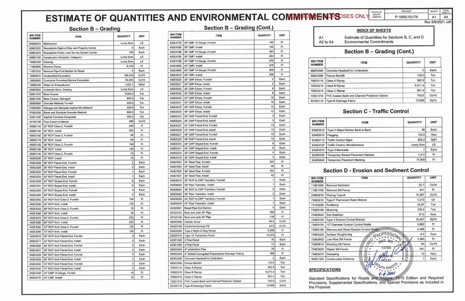
Section B - Grading Section B - Grading (Cont.) INDEX OF SHEETS
BID ITEM ITEM QUANTITY UNIT BID ITEM ITEM QUANTITY UNIT
NUMBER NUMBER A1 Estimate of Quantities for Sections B, C, and D
009E0010 Mobilization Lump Sum LS 450E4778 30" CMP 14 Gauge, Furnish 146 Ft A2 to A4 Environmental Commitments
009E3220 Reestablish Right-of-Way and Property Corner 4 Each 450E4780 30" CMP, Install 146 Ft
009E3225 Reestablish Public Land Survey System Corner 136 Each 450E4788 36" CMP 14 Gauge, Furnish 364 Ft Section B - Grading (Cont.) 009E4100 Construction Schedule, Category I Lump Sum LS 450E4790 36" CMP, Install 364 Ft
100E0100 Clearing Lump Sum LS 450E4798 42" CMP 14 Gauge, Furnish 978 Ft BID ITEM
978 Ft NUMBER ITEM QUANTITY UNIT
110E0600 Remove Fence 8.410 Ft 450E4800 42" CMP, Install
110E7510 Remove Pipe End Section for Reset 4 Each 450E4808 48" CMP 14 Gauge, Furnish 808 Ft 680E2000 Concrete Headwall for Underdrain 2 Each
120E0010 Unclassified Excavation 189,319 CuYd 450E4810 48" CMP, Install 808 Ft 680E2500 Porous Backfill 130.0 Ton
120E0600 Contractor Furnished Borrow Excavation 93,260 CuYd 450E5020 30" CMP Elbow, Furnish 2 Each 700E0110 Class A Riprap 302.9 Ton
120E6100 Water for Embankment 1.902.1 MGal 450E5021 30" CMP Elbow, Install 2 Each 700E0210 Class B Riprap 9,211.4 Ton
250E0020 Incidental Work, Grading Lump Sum LS 450E5025 36" CMP Elbow, Furnish 6 Each
260E1010 Base Course 3,583.0 Ton 450E5026 36" CMP Elbow, Install 6 Each 700E0310 Class C Riprap 831.4 Ton
260E1030 Base Course, Salvaged 840.0 Ton 450E5030 42" CMP Elbow. Furnish 16 Each 720E1010 PVC Coated Bank and Channel Protection Gabion 742.0 CuYd
260E6000 Granular Material, Furnish 420.0 Ton 450E5031 42" CMP Elbow, Install 16 Each 831E0110 Type B Drainage Fabric 12,608 SqYd
270E0020 Salvage and Stockpile Asphalt Mix Material 420.0 Ton 450E5035 48" CMP Elbow, Furnish 12 Each
270E0220 Blend and Stockpile Granular Material 840.0 Ton 450E5036 48" CMP Elbow, Install 12 Each Section C - Traffic Control 320E1200 Asphalt Concrete Composite 450.0 Ton 450E5223 36" CMP Flared End, Furnish 3 Each
450E0142 24" RCP Class 2, Furnish 240 Ft 450E5227 42" CMP Flared End, Furnish 13 Each NUMBER ITEM QUANTITY UNIT
450E0150 24" RCP, Install 240 Ft 450E5228 42" CMP Flared End, Install 13 Each 632E2510 Type 2 Object Marker Back to Back 36 Each
450E0162 30" RCP Class 2. Furnish 94 Ft 450E5231 48" CMP Flared End, Furnish 12 Each 634E0010 Flagging 120.0 Hour
450E0170 30" RCP, Install 94 Ft 450E5232 48" CMP Flared End. Install 12 Each 634E01 10 Traffic Control Signs 825.0 SqFt
450E0182 36" RCP Class 2, Furnish 140 Ft 450E5310 24" CMP Sloped End, Furnish 6 Each 634E0120 Traffic Control, Miscellaneous Lump Sum LS
450E0190 36" RCP, Install 140 Ft 450E5311 24" CMP Sloped End, Install 6 Each
450E5314 30" CMP Sloped End, Furnish Each 634E0275 Type 3 Barricade 7 Each
450E0192 42" RCP Class 2, Furnish 72 Ft 4
450E0200 42" RCP, Install 72 Ft 450E5315 30" CMP Sloped End, Install 4 Each 634E0330 Temporary Raised Pavement Markers 1,314 Ft
450E2028 36" RCP Flared End, Furnish 2 Each 450E7624 24" Steel Pipe, Furnish 302 Ft 634E0640 Temporary Pavement Marking 17,808 Ft
450E2029 36" RCP Flared End. Install 2 Each 450E7625 24" Steel Pipe, Install 46 Ft
450E2032 42" RCP Flared End, Furnish 1 Each 450E7630 30" Steel Pipe, Furnish 160 Ft Section D - Erosion and Sediment Control 450E2033 42" RCP Flared End, Install 1 Each 450E7631 30" Steel Pipe, Install 42 Ft
450E2200 24" RCP Sloped End, Furnish 6 Each 450E8019 30" RCP to CMP Transi tion, Furnish 1 Each BID ITEM ITEM QUANTITY UNIT NUMBER
450E2201 24" RCP Sloped End, Install 6 Each 450E8020 30" Pipe Transition, Install 1 Each 110E1690 Remove Sediment 22.7 CuYd
450E2204 30" RCP Sloped End, Furnish 4 Each 450E8024 36" RCP to CMP Transition. Furnish 2 Each 110E1700 Remove Silt Fence 341 Ft
450E2205 30" RCP Sloped End, Install 4 Each 450E8025 36" Pipe Transition, Install 2 Each 230E0010 Placing Topsoil 19,367 CuYd
450E3042 42" RCP Arch Class 2, Furnish 134 Fl 450E8029 42" RCP lo CMP Transition, Furnish 1 Each 730E0210 Type F Permanent Seed Mixture 1,213 Lb
450E3050 42" RCP Arch , Install 134 Ft 450E8030 42" Pipe Transition, Install 1 Each 731E0200 Fertilizing 34.97 Ton
450E3052 48" RCP Arch Class 2, Furnish 78 Ft 450E9001 Reset Pipe End Section 4 Each
450E3060 48" RCP Arch, Install 78 Ft 451E5124 Bore and Jack 24" Pipe 256 Ft 732E0100 Mulching 108.2 Ton
450E3072 60" RCP Arch Class 2, Furnish 232 Ft 451E5130 Bore and Jack 30" Pipe 118 Ft 734E0044 Soil Stabilizer 47.0 Acre
450E3080 60" RCP Arch, Install 232 Ft 462E0250 Cellular Grout 64.5 CuYd 734E0103 Type 3 Erosion Control Blanket 16,407 SqYd
450E3082 72" RCP Arch Class 2, Furnish 124 Ft 464E0100 Controlled Density Fill 25.9 CuYd 734E0154 12" Diameter Erosion Control Wattle 9,862 Ft
450E3090 72" RCP Arch, Install 124 Ft 620E0020 Type 2 Right-of-Way Fence 8,399 Fl 734E0165 Remove and Reset Erosion Control W.-\!M\\\\IIIIII/IJJ/11, 2,466 Ft
450E4529 60" RCP Arch Flared End, Install 4 Each 680E2000 Concrete Headwall for Underdrain 2 Each 900E1320 Construction Entrance =i~A .I / /'~/,·;;;.; . • f!! ::2 1 Each
450E4532 72" RCP Arch Flared End, Furnish 2 Each 680E2500 Porous Backfill 130.0 Ton ~f/1:'M - -450E4533 72" RCP Arch Flared End, Install 2 Each 700E0110 Class A Riprap 302.9 Ton ~ o\o o'\~. • ~
SPECIFICATIONS ~ ' • • ~l'H Ofl.~. • §§-450E4768 24" CMP 14 Gauge, Furnish 16 Fl 700E0210 Class B Riprap 9,211 .4 Ton ~ . . . . ~
450E4770 24" CMP, Install 16 Ft 700E0310 Class C Riprap 831.4 Ton ~ f -f -UU #" 720E1010 PVC Coaled Bank and Channel Protection Gabion 742.0 CuYd
Standard Specifications for Roads ~l/flj~\\~~ 5 Edition and Required
831E0110 Type B Drainage Fabric 12,608 SqYd Provisions, Supplemental Specifications, an pecial Provisions as included in the Proposal.
FOR BIDDING PURPOSES ONLY
ENVIRONMENTAL COMMITMENTS
The SDDOT is committed to protecting the environment and uses Environmental Commitments as a communication tool for the Engineer and Contractor to ensure that attention is given to avoid, minimize, and/or mitigate an environmental impact. Environmental commitments to various agencies and the public have been made to secure approval of this project. An agency with permitting authority can delay a project if identified environmental impacts have not been adequately addressed. Unless otherwise designated, the Contractor's primary contact regarding matters associated with these commitments will be the Project Engineer. During construction, the Project Engineer will verify that the Contractor has met Environmental Commitment requirements. These environmental commitments are not subject to change without prior written approval from the SDDOT Environmental Office.
Additional guidance on SDDOT's Environmental Commitments can be accessed through the Environmental Procedures Manual found at: <https://dot.sd.gov/media/documents/EnvironmentalProceduresManual.pdf >
For questions regarding change orders in the field that may have an effect on an Environmental Commitment, the Project Engineer will contact the Environmental Engineer at 605-773-3180 or 605-773-4336 to determine whether an environmental analysis and/or resource agency coordination is necessary.
Once construction is complete, the Project Engineer will review all environmental commitments for the project and document their completion.
COMMITMENT A: WETLANDS
All efforts to avoid and minimize wetland impacts from the project have resulted in approximately 0.99 acre of wetlands (includes temporary and permanent) becoming impacted. Refer to Section B - Grading plans/plan sheets for location and boundaries of the impacted wetlands.
Table of Impacted Wetlands
Wetland No.
4
8
9
12
13a
14a
14c
Station
21+53
26+42
48+14
68+16
94+53 to 96+76
89+89
107+00 to
117+00
126+00 to
145+40
Perm. Impact
Left (Acres)
0
0
0.009
0
0
0
0
0
Perm. Temp. Temp. Total Impact Impact Impact
Impact Right Left Right (Acres)
(Acres) (Acres) (Acres)
0.0016 0 0 0.002
0.0067 0 0 0.007
0 0 0 0.009
0.009 0 0 0.009
0.0537 0 0.0548 0.109
0 0 0.0014 0.001
0.039 0 0.0469 0.086
0.032 0 0.445 0.477
16 130+15 0 0 0 0.036 0.036
20a 171+50 0 0.0004 0 0.0005 0.001
21b 189+10 0.0129 0 0 0 0.013
54+00to 0 0.25 0.0 0.0 0.25 Intermittent 1
62+00
Action Taken/Reguired:
Mitigation is required in accordance with the "Statewide Finding Regarding Wetlands for South Dakota Federal-Aid Highway Projects (February 2018)" . Replacement of 0.16 acres of permanent wetland impacts from the Bad, Cheyenne, Belle Fourche 1 (BCB01) wetland mitigation bank site or Ducks Unlimited In-Lieu Fee program to mitigate permanent impacts.
For stream impacts, SDDOT will acquire 1.5 acre credits from the (BCB01) wetland mitigation bank site or 8.25 FCU credits from the Ducks Unlimited In-Lieu Fee program to mitigate permanent impacts for compliance with Section 404 of the Clean Water Act.
Temporary impacts identified in the Table of Impacted Wetlands will not be mitigated as original contours and elevations will be re-established as designated in Section B - Grading Plans/plan sheets. Prior to initiating temporary work in wetlands, the Contractor will submit a plan to the Project Engineer in accordance with Section 7.21 D of the SDDOT Standard Specifications for Roads and Bridges.
The Contractor will notify the Project Engineer if additional easement is needed to complete work adjacent to any wetland. The Project Engineer will obtain an appropriate course of action from the Environmental Office before proceeding with construction activities that affect any wetlands beyond the work limits and easements shown in the plans.
COMMITMENT B: FEDERALLY THREATENED, ENDANGERED, AND PROTECTED SPECIES
COMMITMENT B2: WHOOPING CRANE
The Whooping Crane is a spring and fall migratory bird in South Dakota that is about 5 feet tall and typically stops on wetlands, rivers, and agricultural lands along their migration route. An adult Whooping Crane is white with a red crown and a long, dark, pointed bill. Immature Whooping Cranes are cinnamon brown. While in flight, their long necks are kept straight and their long dark legs trail behind. Adult Whooping Cranes' black wing tips are visible during flight.
Action Taken/Reguired:
Harassment or other measures to cause the Whooping Crane to leave the site is a violation of the Endangered Species Act. If a Whooping Crane is sighted roosting in the vicinity of the project, borrow pits, or staging areas associated with the project, cease construction activities in the affected area until the Whooping Crane departs and immediately contact the Project Engineer. The Project Engineer will contact the Environmental Office so that the sighting can be reported to USFWS.
STATE OF SOUTH
DAKOTA
PROJECT SHEET TOTAL SHEETS
P 1806(15)176 A2 A4
Rev 7/23/2021 JJK
COMMITMENT C: WATER SOURCE
The Contractor will not withdraw water with equipment previously used outside the State of South Dakota or previously used in aquatic invasive species (AIS) positive waters within South Dakota without prior approval from the SDDOT Environmental Office. To prevent and control the introduction and spread of invasive species into the project vicinity, all equipment must be power washed with hot water (~140 °F) and completely dried for a minimum of 7 days prior to subsequent use. South Dakota administrative rule 41: 10:04:02 forbids the possession and transport of AIS; therefore, all attached dirt, mud, debris and vegetation must be removed and all compartments and tanks capable of holding standing water must be drained. This includes, but is not limited to, all equipment, pumps, lines, hoses and holding tanks.
Action Taken/Reguired:
The Contractor will obtain the necessary permits from the regulatory agencies such as the South Dakota Department of Environment and Natural Resources (DENR) and the United States Army Corps of Engineers (USACE) prior to water extraction activities.
Additional information and mapping of water sources impacted by Aquatic Invasive Species in South Dakota can be accessed at: < http://sdleastwanted.com/maps/default.aspx >
Red Plum Creek is classified as fish and wildlife propagation, recreation, irrigation, and stock watering waters. Because of these beneficial uses, special construction measures may have to be taken to ensure that this water body is not impacted.
This project may be in the vicinity of multiple streams and wetlands. These waters are considered waters of the state and are protected under Administrative Rules of South Dakota (ARSD) Chapter 74:51 . Special construction measures may have to be taken to ensure that this water body is not impacted.
Action Taken/Reguired:
The Contractor is advised that the South Dakota Surface Water Quality Standards, administered by the South Dakota Department 9.f Environment and Natural Resources (DENR), apply to this proje~\\\~~H1Hflll1fm-&;uction measures will be taken to ensure the above ~~~qff~ ~ ce waters are maintained and protected. ~ /f;> ••• i..o. N . • ~-1( ~
;§((:-V• ~ Q • ~ :;:: iJ.j • ~ ~ • 1370 ~ • ~ ::: "' . --= a .z = - u M. • m =
~ . • .~o;;~:cf';-•; 1 ~- •;;d:. ;,11"z l ... .#
.• ,,,,,,,11,,11111\\\\\\\\\'·
FOR BIDDING PURPOSES ONLY
COMMITMENT D2: SURFACE WATER DISCHARGE
The DENR General Permit for Temporary Discharge is required for temporary dewatering and discharges to waters of the state. The effluent limit for total suspended solids will be 90 mg/L 30-day average. The effluent limit applies to discharges to all waters of the state except discharges to waters classified as cold water permanent fish life propagation waters according to the ARSD 74:51 :01 :45. For discharges to waters of the state classified as cold water permanent fish life propagation waters, the effluent limit for total suspended solids will be 53 mg/L daily maximum.
The permittee has the option of completing effluent testing or implementing a pollution prevention plan for compliance with this permit. If the permittee develops a pollution prevention plan instead of total suspended solids sampling, the plan must be developed and implemented prior to discontinuing total suspended solids sampling. Refer to Section 4.0 of the permit. If any pollutants are suspected of being discharged, a sample must be taken for those parameters listed in Section 3.4 of the permit.
Refer to Commitment D1: Surface Water Quality for stream classification.
Action Taken/Required:
If construction dewatering is required and this project is currently covered under a General Permit for Stormwater Discharges Associated with Construction Activities, the contractor will need to submit the dewatering information to the SDDENR using the following form:
The Contractor will provide a copy of the approved permit or the submitted dewatering information to the Project Engineer prior to proceeding with any dewatering activities. The approved permit or submitted dewatering information must be kept on-site and as part of the project records.
Effluent monitoring, as a result of dewatering activities, will be summarized for each month and recorded on a separate Discharge Monitoring Report (DMR) and submitted to DENR monthly. Additional information can be found at: < http://denr.sd.gov/des/sw/WhatisaDMR.aspx >
COMMITMENT E: STORM WATER
Construction activities constitute 1 acre or more of earth disturbance and/or work in a waterway.
Action Taken/Required:
The DENR General Permit for Stormwater Discharges Associated with Construction Activities is required for construction activity disturbing one or more acres of earth and work in a waterway. The SDDOT is the owner of this permit and will submit the NOi to DENR 15 days prior to project start in order to obtain coverage under the General Permit. Work can begin once the DENR letter of approval is received .
The Contractor must adhere to the "Special Provision Regarding Storm Water Discharges to Waters of the State."
The Contractor will complete the DENR Contractor Certification Form prior to the pre-construction meeting. The form certifies under penalty of law that the Contractor understands and will comply with the terms and conditions of the permit for this project. Work may not begin on this project until this form is signed and submitted to DENR.
The form can be found at: < https://denr.sd.gov/des/sw/eforms/CGPAppendixCCA2018Fillable.pdf >
The Contractor is advised that permit coverage may also be required for offsite activities, such as borrow and staging areas, which are the responsibility of the Contractor.
The EPA 2017 Construction General Permit is required for this project. The SDDOT is the owner of this permit and will submit the NOi to EPA 15 days prior to project start in order to obtain coverage. Work can begin after authorization is received from the EPA. This permit provides coverage for construction and dewatering activities for this project.
The Contractor must adhere to the "Special Provision Regarding Storm Water Discharge to Waters of the United States within Indian Reservations".
The Contractor is advised that permit coverage may also be required for offsite activities, such as borrow and staging areas, which are the responsibility of the Contractor.
Storm Water Pollution Prevention Plan
The Storm Water Pollution Prevention Plan (SWPPP) will be developed prior to the submittal of the NOi and will be implemented for all construction activities for compliance with the permit. The SWPPP must be kept on-site and updated as site conditions change. Erosion control measures and best management practices will be implemented in accordance with the SWPPP.
The DOT 298 Form will be used for site inspections and to document changes to the SWPPP. A copy of the completed inspection form will be filed with the SWPPP documents and retained for a minimum of three years.
The inspection will include disturbed areas of the construction site that have not been finally stabilized, areas used for storage materials, structural control measures, and locations where vehicles enter or exit the site. These areas will be inspected for evidence of, or the potential for, pollutants entering the drainage system. Erosion and sediment control measures identified in the SWPPP will be observed to ensure that they are operating correctly, and sediment is not tracked off the site.
Information on storm water permits and SWPPPs are available on the following websites:
The Contractor will furnish a site(s) for the disposal of construction and/or demolition debris generated by this project.
Action Taken/Required:
Construction and/or demolition debris may not be disposed of within the Public ROW.
The waste disposal site(s) will be managed and reclaimed in accordance with the following from the General Permit for Construction/Demolition Debris Disposal Under the South Dakota Waste Management Program issued by the Department of Environment and Natural Resources.
The waste disposal site(s) will not be located in a wetland, within 200 feet of surface water, or in an area that adversely affects wildlife, recreation, aesthetic value of an area, or any threatened or endangered species, as approved by the Environmental Office and the Project Engineer.
If the waste disposal site(s) is located such that it is within view of any ROW, the following additional requirements will apply:
1. Construction and/or demolition debris consisting of concrete, asphalt concrete, or other similar materials will be buried in a trench separate from wood debris. The final cover over the construction and/or demolition debris will consist of a minimum of 1 foot of soil capable of supporting vegetation. Waste disposal sites provided outside of the Public ROW will be seeded in accordance with Natural Resources Conservation Service recommendations. The seeding recommendations may be obtained through the appropriate County NRCS Office. The Contractor will control the access to waste disposal sites not within the Public ROW with fences, gates, and placement of a sign or signs at the entrance to the site stating, "No Dumping Allowed".
2. Concrete and asphalt concrete debris may be stockpiled within view of the ROW for a period not to exceed the duration of the project. Prior to project completion, the waste must be removed from view of the ROW or buried, and the waste disposal site reclaimed as noted above.
The above requirements will not apply to waste disposal sites that are covered by an individual solid waste permit as specified in SDCL 34A-6-58, SDCL 34A-6-1 .13, and ARSD 74:27:10:06.
Failure to comply with the requirements stated above may result in civil penalties in accordance with South Dakota Solid Waste Law, SDCL 34A-6-1.31.
The SDDOT has obtained concurrence with the State Historic Preservation Office (SHPO or THPO) for all work included within the project limits and all department designated sources and designated option material sources, stockpile sites, storage areas, and waste sites provided within the plans.
Action Taken/Required:
All earth disturbing activities not designated within the plans require a cultural resource review prior to scheduling the pre-construction meeting. This work includes but is not limited to: Contractor furnished material sources, material processing sites, stockpile sites, storage areas, plant sites, and waste areas.
The Contractor will arrange and pay for a record search and when necessary, a cultural resource survey. The Contractor has the option to contact the state Archaeological Research Center (ARC) at 605-394-1936 or another qualified archaeologist, to obtain either a records search or a cultural resources survey. A record search might be sufficient for review if the site was previously surveyed; however, a cultural resources survey may need to be conducted by a qualified archaeologist.
The Contractor will provide ARC with the following: a topographical map or aerial view in which the site is clearly outlined, site dimensions, project number, and PCN. If applicable, provide evidence that the site has been previously disturbed by farming, mining, or construction activities with a landowner statement that artifacts have not been found on the site.
The Contractor will submit the cultural resources survey report to SDDOT Environmental Office, 700 East Broadway Avenue, Pierre, SD 57501-2586. SDDOT will submit the information to the appropriate SHPO/THPO. Allow 30 Days from the date this information is submitted to the Environmental Engineer for SHPO/THPO review.
In the event of an inadvertent discovery of human remains, funerary objects, or if evidence of cultural resources is identified during project construction activities, then such activities within 100 feet of the inadvertent discovery will immediately cease and the Project Engineer will be immediately notified. The Project Engineer will contact the SDDOT Environmental Office, who will contact the appropriate SHPO/THPO within 48 hours of the discovery to determine an appropriate course of action.
SHPO/THPO review does not relieve the Contractor of the responsibility for obtaining any additional permits and clearances for Contractor furnished material sources, material processing sites, stockpile sites, storage areas, plant sites, and waste areas that affect wetlands, threatened and endangered species, or waterways. The Contractor will not utilize a site known or suspected of having contaminated soil or water. The Contractor will provide the required permits and clearances to the Project Engineer at the preconstruction meeting .
COMMITMENT N: SECTION 404 PERMIT
The SDDOT has obtained a Section 404 Permit from the USACE for the permanent actions associated with this project.
Action Taken/Required:
The Contractor will comply with all requirements contained in the Section 404 Permit.
The Contractor will also be responsible for obtaining a Section 404 Permit for any dredge, excavation, or fill activities associated with material sources, storage areas, waste sites, and Contractor work sites outside the plan work limits that affect wetlands, floodplains, or waters of the United States.