2.3 Origin and Character of Natural Deposits ............................ 2-9 2.3.1 Residual Soils .......................................................... 2-9 2.3.2 Gravity Transported Soils or Colluvium ............... 2-10 2.3.3 River Deposits (Alluvium) ..................................... 2-11 2.3.4 Lake Deposits ........................................................ 2-17 2.3.5 Glacial Deposits ..................................................... 2-18
2.4 Subsurface Water in Soil .................................................... 2-23 2.5 Nature and Origin of Rock Deposits ................................... 2-25 2.6 Classification of Rock Types .............................................. 2-27 2.7 Rock Types ......................................................................... 2-29
2.8 Weathering of Rock ............................................................ 2-37 2.9 Subsurface Water in Rock .................................................. 2-43 2.10 Self-Test .............................................................................. 2-45
WPC #27374 07/09 AMRC 2011 2-1
Module 2
The Nature and Origin of Soil and Rock Deposits
Overview This module introduces processes responsible for the formation of soil and rock. The geologic processes are important in understanding the history of a deposit. It is the history of a material that affects the engineering properties of that material. This module also describes classification of rocks and describes the geologic process involved in the formation of rock. The engineering properties of rock are influenced by rock type and internal rock structure (that is internal cracks or weaknesses within the rock.)
Objectives Upon successful completion of this module, you will be able to: describe the term geology and relate its importance to the field
of engineering describe the processes that take place in the formation of soils understand and discuss the origin and character of soils in their
natural deposits recognize and explain the effects of subsurface water on the
behaviour of soils and on their engineering properties describe the major classifications of rock and explain the
methods used in rock identification and classification describe the processes that take place during the formation of
igneous, sedimentary and metamorphic rocks describe the purpose and use of sight recognition and rock
identification tables and figures utilized by the Ministry of Transportation
describe the various components of the structure of an existing
body of rock.
MODULE 2 The Nature and Origin of Soil and Rock Deposits
WPC #27374 07/09 2-2 AMRC 2011
Procedures Study the module materials and make notes as required. Perform the self-test on these principles and review the course
materials in such a manner as to be able to successfully complete similar questions upon examination.
WPC #27374 07/09 AMRC 2011 2-3
SECTION 2.1
Nature and Origin of Soil Deposits
Geology is the science which studies the composition, history and structure of the earth’s crust. While it is readily apparent that a thorough understanding of soil mechanics is essential in the practice of geotechnical engineering, a significant degree of insight into a particular soils problem may also be achieved through a knowledge of the geological process. Indeed, as was briefly indicated in the previous module, soil, a mixture of individual grains of rock, is one result of the geological process. Soil can be thought of as having a past, present and future. The geological process has usually played the major role in the past history of the soil leading to its present conditions. These are the conditions that have to be investigated in order to estimate its future behaviour, such as settlement under a foundation load, road fill or bridge abutment. Lack of appreciation of the geological process can lead to errors in judgement of the present condition of a soil, and so to wrong estimations of future behaviour.
MODULE 2 The Nature and Origin of Soil and Rock Deposits
WPC #27374 07/09 2-4 AMRC 2011
WPC #27374 07/09 AMRC 2011 2-5
SECTION 2.2
Rock and Soil Formation
The earth is constantly changing. You only have to watch the evening news where stories of floods, earthquakes, volcanic eruptions, etc. to understand that it is still evolving. However, longer term, the billion years or so of documented geological history have seen many changes that leave their imprints in the soils and rocks that comprise the earth’s crust. The cycles of change in rock and soil formation and alteration are shown in Figure 2.1.
Figure 2.1 Cycles of Change in Soil and Rock Formation
Figure 2.1 may appear complex. This is inevitable as the history of a grain of soil or fragment of rock may be quite complex. The entire earth’s crust was probably at one stage a soft sticky liquid skin that slowly hardened into igneous rock. This crust is still being augmented by magma (molten rock deep below the earth’s crust) that occasionally flows or boils up from the depths of the earth. The process of weathering, aggravated by wrinkling and cracking of the crust attacks the rock, creating residual soils, the in situ (in place) products of decomposition, solution and local disintegration. These are not common in Canada but occur in tropical areas. Some of these materials are transported by gravity, through sliding and creep, to
MODULE 2 The Nature and Origin of Soil and Rock Deposits
WPC #27374 07/09 2-6 AMRC 2011
make deposits nearby. Other materials are transported still greater distances by wind, water and ice. They are mixed together, often sorted out by size and then laid down in a new environment as deposited or sedimentary soils.
2.2.1 Sedimentary Soils The deposited soils continue to weather, and some are retransported
and redeposited in new formations. Others become indurated (hardened) by consolidation and are cemented into sedimentary rocks. The sedimentary rocks are subject to the same distortion and fracturing produced by movements of the earth’s crust as the igneous rocks. Similarly, environmental changes can subject them to in situ weathering that produces new residual soils. This is followed by the processes of erosion and transportation that eventually create new, deposited soils. Instead of being exposed to weathering and erosion, the sedimentary rocks may be buried beneath accumulating sediments and be subjected to increasing heat, pressure and shear. The minerals are altered chemically and distorted or realigned physically to produce metamorphic rocks. The new rocks may resemble their ancestors but they are often more crystalline, denser and harder. The metamorphic rocks are subject to weathering if exposed. The result of this weathering is to form residual soils which are eventually transported and mixed into new sedimentary deposits. Igneous rocks may also be metamorphosed (transformed) by heat, pressure and shear. Finally, the metamorphic rock can be transformed back to igneous rock by heat, pressure and the addition of new minerals from molten masses below. The cycle is replete with shortcuts and reversals, but it is continuous, with no definite beginning or end point. These cycles take many millions of years. Engineering is merely another process added to the cycle, an insignificant one in the total pattern but, locally, often drastic.
2.2.2 Continental Drift Continental drift is a simplified model of earth crustal behaviour
which may explain the occurrences of mountain ranges, volcanic belts, mid ocean ridges, ocean trenches, wide coastal plains, earthquakes, etc. The theory of continental drift is not of much immediate help to a construction foreman faced with a soil problem over a 100 metre section of road, but it is a major force in the creation of land forms. Anyone employed in the civil engineering field should obtain an increased awareness from a simple appreciation of this hypothesis.
MODULE 2 The Nature and Origin of Soil and Rock Deposits
WPC #27374 07/09 AMRC 2011 2-7
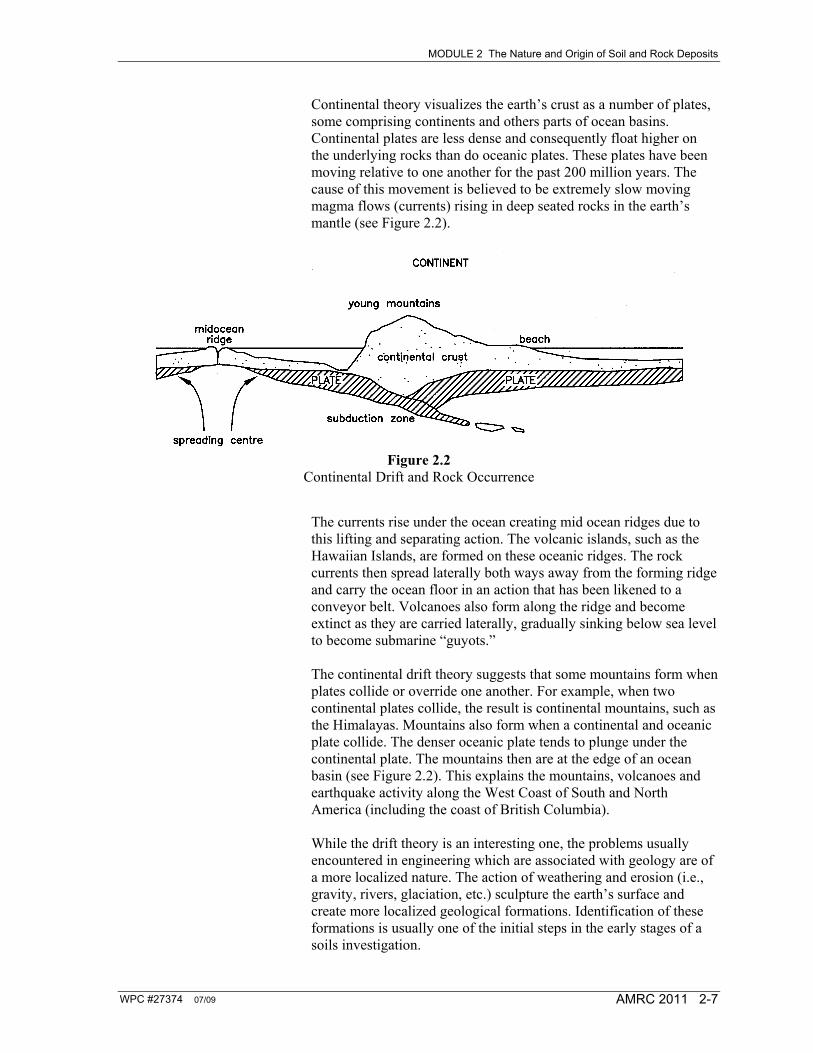
Continental theory visualizes the earth’s crust as a number of plates, some comprising continents and others parts of ocean basins. Continental plates are less dense and consequently float higher on the underlying rocks than do oceanic plates. These plates have been moving relative to one another for the past 200 million years. The cause of this movement is believed to be extremely slow moving magma flows (currents) rising in deep seated rocks in the earth’s mantle (see Figure 2.2).
Figure 2.2
Continental Drift and Rock Occurrence The currents rise under the ocean creating mid ocean ridges due to this lifting and separating action. The volcanic islands, such as the Hawaiian Islands, are formed on these oceanic ridges. The rock currents then spread laterally both ways away from the forming ridge and carry the ocean floor in an action that has been likened to a conveyor belt. Volcanoes also form along the ridge and become extinct as they are carried laterally, gradually sinking below sea level to become submarine “guyots.” The continental drift theory suggests that some mountains form when plates collide or override one another. For example, when two continental plates collide, the result is continental mountains, such as the Himalayas. Mountains also form when a continental and oceanic plate collide. The denser oceanic plate tends to plunge under the continental plate. The mountains then are at the edge of an ocean basin (see Figure 2.2). This explains the mountains, volcanoes and earthquake activity along the West Coast of South and North America (including the coast of British Columbia). While the drift theory is an interesting one, the problems usually encountered in engineering which are associated with geology are of a more localized nature. The action of weathering and erosion (i.e., gravity, rivers, glaciation, etc.) sculpture the earth’s surface and create more localized geological formations. Identification of these formations is usually one of the initial steps in the early stages of a soils investigation.
MODULE 2 The Nature and Origin of Soil and Rock Deposits
WPC #27374 07/09 2-8 AMRC 2011
WPC #27374 07/09 AMRC 2011 2-9
SECTION 2.3
Origin and Character of Natural Deposits
2.3.1 Residual Soils Residual soils are found wherever the rate of weathering exceeds the rate at which the products of weathering are removed by erosion. In gently sloping terrain in the tropics they may be a hundred metres or more thick. In cool regions the weathering is slow and the residual blanket is thinner; in Greenland it is only centimetres thick. Moreover, in much of the Northern Hemisphere, glacial action has ploughed away the residual accumulations leaving ancient igneous rocks, such as the Canadian Shield, naked, except for local pockets of soil cover. There is no well-defined boundary between the weathered rock (residual soil) and the underlying intact rock, only a transition from the one to the other. The weathering extends deepest and is most advanced along joints and in shear planes. In jointed rock, weathering from the joints inward creates plane-sided, “unweathered” blocks with rounded edges that resemble boulders, which float in a matrix of the more completely weathered soil (see Figure 2.3). The identification of the degree of weathering in rock, and the interpretation of its effect on engineering structures, is of prime importance when design and construction is undertaken in material of this type.
MODULE 2 The Nature and Origin of Soil and Rock Deposits
WPC #27374 07/09 2-10 AMRC 2011
Figure 2.3 Boulder-like Blocks Produced by Weathering along Joints
2.3.2 Gravity Transported Soils or Colluvium All soils are subjected, partially at least, to transportation by gravity
alone. Residual soils in rolling areas tend to move slowly down hill (a process known as creep) but the general character of the soil deposit is usually not changed. Creep is important in that structures on shallow foundations may be moved out of position (this can happen to roads) and structures on deep, rigid foundations (e.g., bridges) may be damaged by the pressure of the moving mass.
Figure 2.4 Talus and Soil Creep
A talus slope is an accumulation of fallen rock and rock debris at the bases of steep rock slopes and faces (see Figure 2.4). It is composed
MODULE 2 The Nature and Origin of Soil and Rock Deposits
WPC #27374 07/09 AMRC 2011 2-11
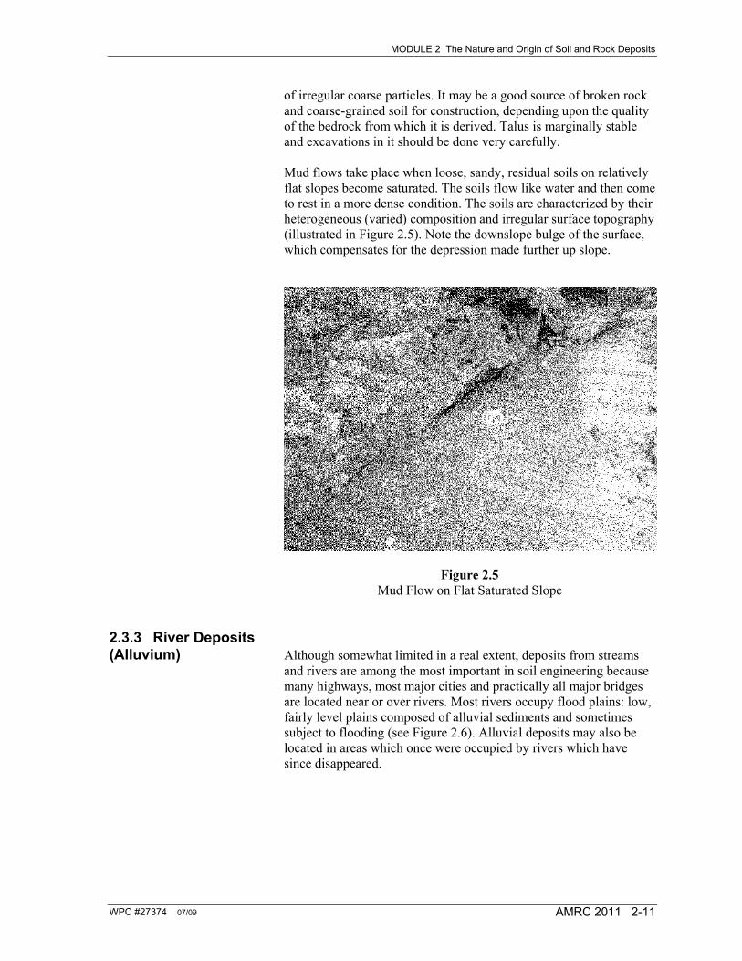
of irregular coarse particles. It may be a good source of broken rock and coarse-grained soil for construction, depending upon the quality of the bedrock from which it is derived. Talus is marginally stable and excavations in it should be done very carefully. Mud flows take place when loose, sandy, residual soils on relatively flat slopes become saturated. The soils flow like water and then come to rest in a more dense condition. The soils are characterized by their heterogeneous (varied) composition and irregular surface topography (illustrated in Figure 2.5). Note the downslope bulge of the surface, which compensates for the depression made further up slope.
Figure 2.5 Mud Flow on Flat Saturated Slope
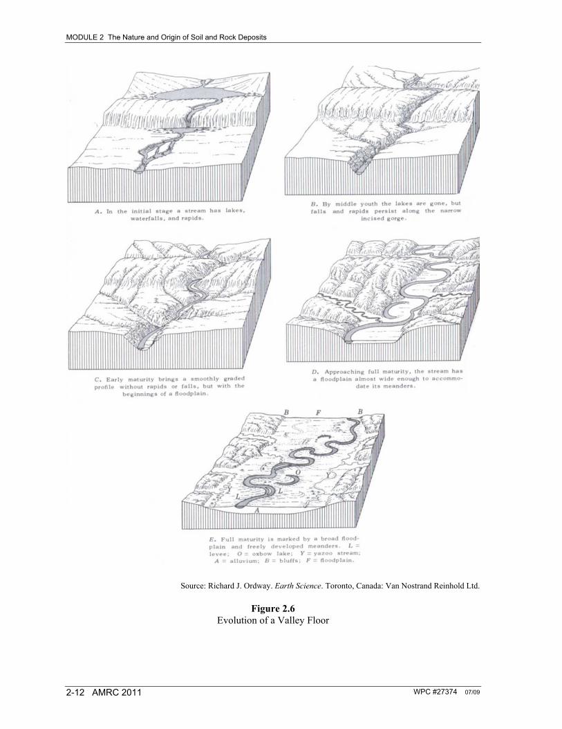
2.3.3 River Deposits (Alluvium) Although somewhat limited in a real extent, deposits from streams
and rivers are among the most important in soil engineering because many highways, most major cities and practically all major bridges are located near or over rivers. Most rivers occupy flood plains: low, fairly level plains composed of alluvial sediments and sometimes subject to flooding (see Figure 2.6). Alluvial deposits may also be located in areas which once were occupied by rivers which have since disappeared.
MODULE 2 The Nature and Origin of Soil and Rock Deposits
WPC #27374 07/09 2-12 AMRC 2011
Source: Richard J. Ordway. Earth Science. Toronto, Canada: Van Nostrand Reinhold Ltd.
Figure 2.6 Evolution of a Valley Floor
MODULE 2 The Nature and Origin of Soil and Rock Deposits
WPC #27374 07/09 AMRC 2011 2-13
Rivers with flood plains are said to be mature (see Figure 2.6). This means that down cutting is being prevented by a base level, and that the river’s excess energies have been diverted from cutting the soil downwards to lateral cutting; it is this which makes the flood plain. Hard rock outcrops may form local base levels, but the ultimate and most important base level is sea level or lake level. A stream cannot cut vertically much below sea level, or it would have to run uphill. Streams that have not cut to base level, such as mountain streams, gullies and small tributaries that make up most of the drainage pattern, are called youthful (see Figure 2.6). They occupy V-shaped valleys and have no flood plain except perhaps for a narrow smear of poorly-sorted, localized alluvium (material deposited by the river). Running water is one of the most active agents for soil transportation. As a transporting agent, water serves to mix soil from several different sources and then sorts and deposits them according to grain size. Small soil particles are lifted by the turbulence of the water and are carried downstream with little physical change, while larger particles of sand, gravel and even boulders are rolled along the streambed to become ground down and rounded by abrasion. During periods of high discharge, rivers carry tremendous volumes of coarse and fine particles; in periods of low flow, only small quantities of fine particles may be transported. If the stream velocity increases, as it does where steeper portions of its channel are reached or when rainfall raises the level of flow, the river erodes its channel until its capacity to transport material is reached. If the stream velocity decreases because of flatter slopes or decreased flow, some of the transported particles are deposited with the largest particles being dropped first. Streams in arid regions are characterized by flash floods and prolonged periods of little or no flow. Tremendous quantities of small boulders, gravel and sand may be carried during periods of high water, but the volume of material transported in dry weather is negligible. The deposits formed downstream from the steeper portions of such a river, where the erosion is high, fill the channel to great depths. They also form narrow terraces of gravel and sand parallel to the low water channel. Both shift and change during every flood season. At the point where the river enters flat country, its velocity is sharply checked, and some of its load is deposited in the form of a flat triangular mass termed an alluvial fan (see Figure 2.7).
MODULE 2 The Nature and Origin of Soil and Rock Deposits
WPC #27374 07/09 2-14 AMRC 2011
Figure 2.7 Alluvial Fan
The fans from adjacent rivers join up along the foot of the mountains to form a sloping mass: a thick, tilted, undulating surface underlain by thick, erratic deposits of silty sand and gravel. The valley below this mass becomes filled with irregular lens-like masses of silt, sand and gravel brought by the rivers during flooding. The stream chokes its channel solid after every period of high discharge and this forces it to break through into a new course. This is called braiding and such a braided stream is shown in Figure 2.8.
MODULE 2 The Nature and Origin of Soil and Rock Deposits
WPC #27374 07/09 AMRC 2011 2-15
Figure 2.8 Braided Streams
These valley fills are usually very loose, although they may develop some cementing because of continuing weathering. These cemented soils often collapse when saturated, causing canals to slough and foundations to settle. Both the alluvial fans and braided stream deposits in the valley fills may provide good sources of sand and gravel for construction. Streams in humid regions are characterized by floods and sustained dry weather flow. The particles carried by such streams are likely to be finer than those carried by streams in arid regions because the flood velocities tend to be smaller, and because the greater degree of weathering in a humid region produces a much larger proportion of fines. The deposits downstream from the steeper portions of streams in humid regions are similar to those formed by streams in arid regions but they are smaller and less likely to shift during every period of high water. Where these rivers enter flat valleys, they tend to form alluvial fans that are broad and flat and composed largely of sand and fine gravels. River deposits in flat valleys in humid regions (Figure 2.9) are very important because valleys are often the sites of highways, railroads, airfields, industrial plants and large cities. During period of low flow, the stream is confined in its channels and deposition is balanced by erosion. During flood periods, however, it overflows its banks and floods the valley to form immense lakes and broad, flat sheets of slowly moving water. The velocity in the overflow areas is so much smaller than in the channel that deposition takes place along the banks of the channel forming natural levees. The broad overflow areas act as settling basins in which the fine particles are deposited out of slowly moving water. As the flood
MODULE 2 The Nature and Origin of Soil and Rock Deposits
WPC #27374 07/09 2-16 AMRC 2011
subsides, still finer particles are deposited until evaporation reduces the remaining puddles to dust. Flood plain deposits consist of broad, flat, thin strata of very fine sands and clays with occasional elongated lenses of sand that formed in temporary channels or sloughs.
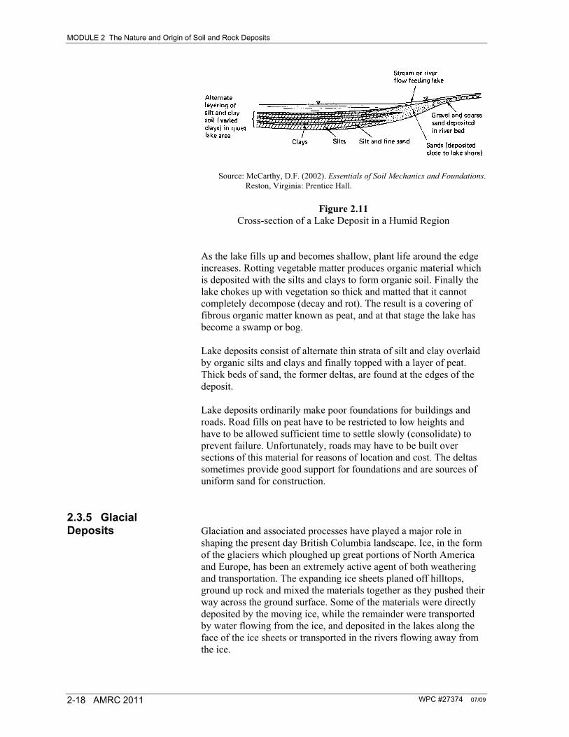
Source: McCarthy, D.F. (2002). Essentials of Soil Mechanics and Foundations. Reston, Virginia: Prentice Hall.
Figure 2.9 Cross-section of a Flood Plain of an Old River in a Humid Region
The lowest part of the flood plain is often farthest from the river and the last area to become dry after flooding. It is termed the back swamp because of the wet, soft soil and swampy organic matter that accumulates there.
Figure 2.10 Meandering in an Old Valley
MODULE 2 The Nature and Origin of Soil and Rock Deposits
WPC #27374 07/09 AMRC 2011 2-17
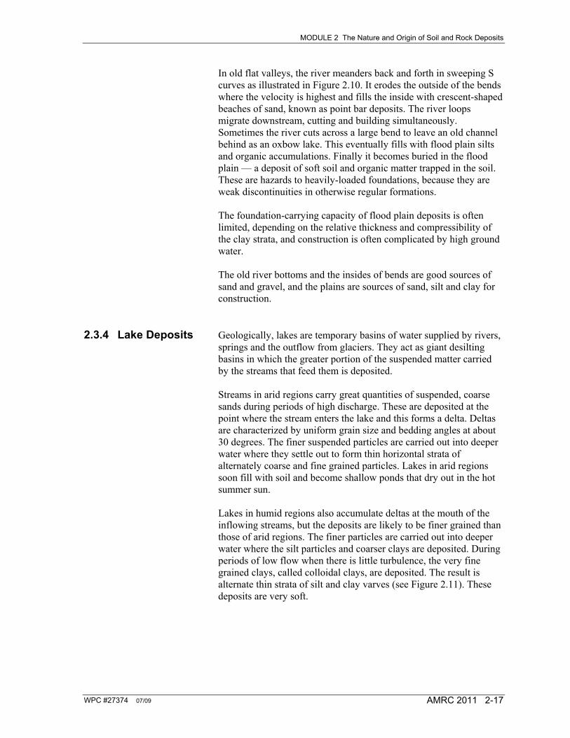
In old flat valleys, the river meanders back and forth in sweeping S curves as illustrated in Figure 2.10. It erodes the outside of the bends where the velocity is highest and fills the inside with crescent-shaped beaches of sand, known as point bar deposits. The river loops migrate downstream, cutting and building simultaneously. Sometimes the river cuts across a large bend to leave an old channel behind as an oxbow lake. This eventually fills with flood plain silts and organic accumulations. Finally it becomes buried in the flood plain — a deposit of soft soil and organic matter trapped in the soil. These are hazards to heavily-loaded foundations, because they are weak discontinuities in otherwise regular formations. The foundation-carrying capacity of flood plain deposits is often limited, depending on the relative thickness and compressibility of the clay strata, and construction is often complicated by high ground water. The old river bottoms and the insides of bends are good sources of sand and gravel, and the plains are sources of sand, silt and clay for construction.
2.3.4 Lake Deposits Geologically, lakes are temporary basins of water supplied by rivers, springs and the outflow from glaciers. They act as giant desilting basins in which the greater portion of the suspended matter carried by the streams that feed them is deposited. Streams in arid regions carry great quantities of suspended, coarse sands during periods of high discharge. These are deposited at the point where the stream enters the lake and this forms a delta. Deltas are characterized by uniform grain size and bedding angles at about 30 degrees. The finer suspended particles are carried out into deeper water where they settle out to form thin horizontal strata of alternately coarse and fine grained particles. Lakes in arid regions soon fill with soil and become shallow ponds that dry out in the hot summer sun. Lakes in humid regions also accumulate deltas at the mouth of the inflowing streams, but the deposits are likely to be finer grained than those of arid regions. The finer particles are carried out into deeper water where the silt particles and coarser clays are deposited. During periods of low flow when there is little turbulence, the very fine grained clays, called colloidal clays, are deposited. The result is alternate thin strata of silt and clay varves (see Figure 2.11). These deposits are very soft.
MODULE 2 The Nature and Origin of Soil and Rock Deposits
WPC #27374 07/09 2-18 AMRC 2011
Source: McCarthy, D.F. (2002). Essentials of Soil Mechanics and Foundations. Reston, Virginia: Prentice Hall.
Figure 2.11 Cross-section of a Lake Deposit in a Humid Region
As the lake fills up and becomes shallow, plant life around the edge increases. Rotting vegetable matter produces organic material which is deposited with the silts and clays to form organic soil. Finally the lake chokes up with vegetation so thick and matted that it cannot completely decompose (decay and rot). The result is a covering of fibrous organic matter known as peat, and at that stage the lake has become a swamp or bog. Lake deposits consist of alternate thin strata of silt and clay overlaid by organic silts and clays and finally topped with a layer of peat. Thick beds of sand, the former deltas, are found at the edges of the deposit. Lake deposits ordinarily make poor foundations for buildings and roads. Road fills on peat have to be restricted to low heights and have to be allowed sufficient time to settle slowly (consolidate) to prevent failure. Unfortunately, roads may have to be built over sections of this material for reasons of location and cost. The deltas sometimes provide good support for foundations and are sources of uniform sand for construction.
2.3.5 Glacial Deposits Glaciation and associated processes have played a major role in
shaping the present day British Columbia landscape. Ice, in the form of the glaciers which ploughed up great portions of North America and Europe, has been an extremely active agent of both weathering and transportation. The expanding ice sheets planed off hilltops, ground up rock and mixed the materials together as they pushed their way across the ground surface. Some of the materials were directly deposited by the moving ice, while the remainder were transported by water flowing from the ice, and deposited in the lakes along the face of the ice sheets or transported in the rivers flowing away from the ice.
MODULE 2 The Nature and Origin of Soil and Rock Deposits
WPC #27374 07/09 AMRC 2011 2-19
Source: Production of Construction Aggregates
Figure 2.12
Glacier-formed Deposits Figure 2.12 shows the various deposits that are formed by glaciers. During the advancement stage, the material is pushed ahead of the glacier like a bulldozer. The material is windrowed around the front of the glacier. This deposit is called a moraine. When the glacier recedes, this material is left behind and called a terminal or end moraine (see Figures 2.13 and 2.14). If material is pushed off to the flank of the advancing glacier tongue, then the deposit is called a lateral moraine. Moraine materials are usually an unsorted conglomeration of all sizes, from large boulders to silts. Drumlins are elongated low hills of till which point in the direction of the ice travel (see Figure 2.15). They occur in areas of ground moraines and possibly represent deposits of soil that accumulated in crevasses in the ice. During a recession stage of the glacier, tremendous volumes of water emanate from the glacier. The water, in the form of braided streams, continues transporting the material that has been picked up by the glacier and will sort, deposit and erode the material as it makes its way to its final destination (see Figure 2.15).
MODULE 2 The Nature and Origin of Soil and Rock Deposits
WPC #27374 07/09 2-20 AMRC 2011
Water can form underneath the glacier and develop a tunnel within the glacier. The washing action within the tunnel will wash out material that is imbedded within the ice. The sorting within the tunnel will produce, once the glacier has melted, a long ribbon-like deposit of coarse materials. These deposits are called eskers. Eskers are a landform which are easily identifiable from the air, in some cases stretching hundreds of metres in length. They are narrow in width, approximately ten to thirty metres in height, with a side slope of about thirty degrees. During the melting stage, water will run along the sides of the glacier and expose bedrock mountain slopes. The water will carry material and deposit it between the ice and the bedrock. This material is called a kame. When the glacier recedes, a deposit of rounded, sorted sands and gravels are left, usually raised above the valley floor. This is referred to as a kame terrace. The material formed underneath the glacier and compacted by the weight of the ice forms a heterogeneous material called lodgement till. Glacial tills are common throughout North America and are identifiable usually by their bluish colour. Tills are not a good source of aggregate because they contain a high percentage of silts and clays, however, some washed tills can produce a reasonably good source of gravel.
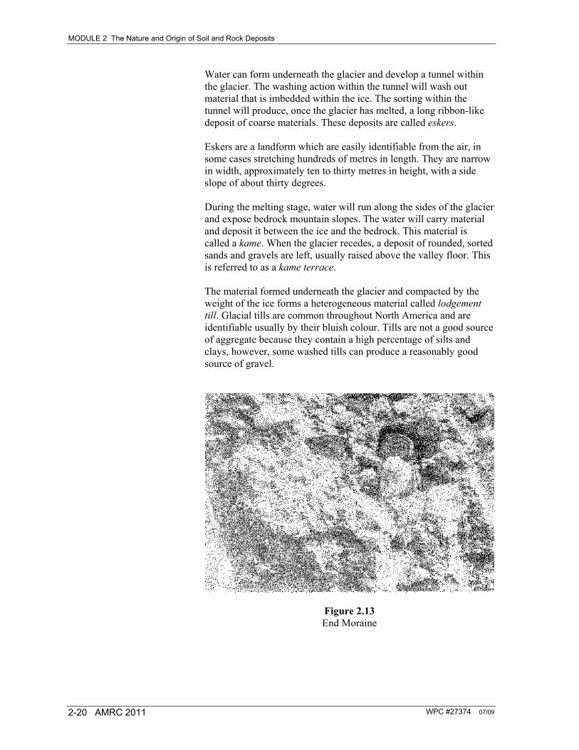
Figure 2.13 End Moraine
MODULE 2 The Nature and Origin of Soil and Rock Deposits
WPC #27374 07/09 AMRC 2011 2-21
Figure 2.14 End Moraine
Figure 2.15 Drumlins
MODULE 2 The Nature and Origin of Soil and Rock Deposits
WPC #27374 07/09 2-22 AMRC 2011
Figure 2.16 Eskers
In many areas the glacial streams flowed into large lakes that formed in depressions left by the retreating ice. The deposits in these lakes are similar to those formed in other lakes, except that they are more extensive. Great deltas of sand formed at the mouth of the rivers, and thick beds of silt and clay formed in the still, deep waters beyond the shore. Occasional boulders and gravel found in the clay are believed to have been dropped by floating pieces of ice as they melted. The silts and clays are often in thin, alternate strata which represent seasonal variations in the rate at which the ice melted and thus the resulting rate of stream flow. The coarser particles were deposited in summer during periods of high discharge, the clays were deposited in winter. Such deposits are known as varved clays when the individual strata are more that 3 mm thick, and laminated clays when the strata are thinner.
A characteristic of a glacial deposit is usually the shape of the aggregates themselves. Glacial erosion tends not to round the particles as water erosion does. Therefore, aggregates that are angular in shape tend to be deposited by glaciers. In addition, glaciers do not sort the aggregate sizes out as uniformly as water, therefore it is likely that there will be a wide range of concentrations of one particular size of aggregate, with other particle sizes missing.
Glacial sands, gravels and till usually make good foundations. They are also good sources of construction materials. The identification of the various types of glacial land forms is one factor which aids in locating gravel pits. The glacial clays are only moderately strong and often cause foundation design problems. Also, newly exposed surfaces in some clays tend to weaken with time so that failures often result several years after construction.
There are two other natural deposits: marine and wind, but these are not of major importance to this course.
WPC #27374 07/09 AMRC 2011 2-23
SECTION 2.4
Subsurface Water in Soil
Water in soils plays a major role in determining the behaviour of the soil and the structures placed on it (Figure 2.17). When the soil is completely saturated with water, the zone of water is called ground water. The upper surface of the ground water is called the water table. If a hole is dug into this zone, water will enter the hole from the surrounding soil and will stand in the hole to the level of the water table.
Figure 2.17 Ground Water and Water Table
Ground water is not usually stationary and the water table not usually level. The body of water is constantly moving up and down and through the soil matrix if there is a slope involved. It is fed by seepage from the ground and can lose water by seepage into rivers and streams (see Figure 2.18).
Figure 2.18 Movement of Ground Water
MODULE 2 The Nature and Origin of Soil and Rock Deposits
WPC #27374 07/09 2-24 AMRC 2011
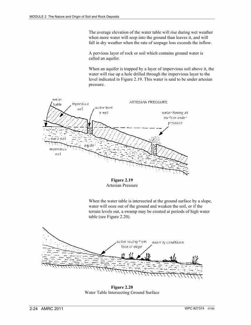
The average elevation of the water table will rise during wet weather when more water will seep into the ground than leaves it, and will fall in dry weather when the rate of seepage loss exceeds the inflow. A pervious layer of rock or soil which contains ground water is called an aquifer. When an aquifer is trapped by a layer of impervious soil above it, the water will rise up a hole drilled through the impervious layer to the level indicated in Figure 2.19. This water is said to be under artesian pressure.
Figure 2.19
Artesian Pressure When the water table is intersected at the ground surface by a slope, water will ooze out of the ground and weaken the soil, or if the terrain levels out, a swamp may be created at periods of high water table (see Figure 2.20).
Figure 2.20
Water Table Intersecting Ground Surface
WPC #27374 07/09 AMRC 2011 2-25
SECTION 2.5
Nature and Origin of Rock Deposits
The geological origins of the three major classifications of rocks, igneous, sedimentary and metamorphic, were briefly discussed in the previous sections. Figure 2.1 illustrates the continual cycles of change which rocks are undergoing and the agents of these changes (heat, pressure, mineralization, shear, etc.). Incorporated within these three major classifications are many types of rocks whose properties vary widely. In addition, these rocks may be fractured and weathered to a greater or lesser degree. Identification and classification of these rocks and the degree and nature of the fracturing and weathering has to be made prior to design and construction, as these factors have a profound effect upon rock structures. A very common example, which is frequently encountered in BC during the construction of roads, is that of rock slope stability. The type of rock and the localized direction of weakness in the rock can very rapidly change what may have been straightforward construction into an extremely difficult and expensive project. With few exceptions, rocks are aggregates of mineral grains, sometimes of a single mineral but more often of several minerals. The mineral grains may be held together by a cementing material, as are sand grains in sandstone, or they may be firmly held together by crystalline bonds, as in granite. Of course, special cases may be cited: a conglomerate is made up of pebbles which themselves are mineral aggregates. There is also obsidian which is a volcanic, glassy rock that has cooled too rapidly from a molten condition for crystals to form. Petrology is the science of rocks. It deals with more or less definite units of which the earth is built. Petrography comprises the purely descriptive part of the science from the chemical-mineralogical and textural point of view.
MODULE 2 The Nature and Origin of Soil and Rock Deposits
WPC #27374 07/09 2-26 AMRC 2011
WPC #27374 07/09 AMRC 2011 2-27
SECTION 2.6
Classification of Rock Types
Most rock classifications are based on the kinds and amounts of minerals present in the rock. A mineral is a natural inorganic substance of a definite chemical composition and, if formed under favourable conditions, has a certain characteristic molecular structure that is exhibited by its crystalline form and other physical properties. The classification of minerals is primarily a chemical one — hardly adaptable to quick or easy means of identification. For sight recognition, physical properties and the shape of the crystals of the minerals are used. Of these, the optical properties of the crystals, determined by a polarizing microscope, are the most important in the description and determination of minerals. The study of the chemical, structural and physical properties of minerals is known as mineralogy. Although today about 2000 minerals can be recognized, fortunately most common rocks contain relatively few of them, as practically the entire earth’s crust is composed of about 20 minerals. The most common rock forming minerals are feldspars, quartz, mica, pyroxene and amphibole. Except for quartz, which is a mineral on its own, the others represent groups or family names of minerals. The physical characteristics used to identify minerals are crystal form, hardness, colour and lustre, and the colour (streak) of the powdered mineral. Some varieties of rock grade into one another. Thus there is every gradation from a shale to a sandy shale to a shaly sandstone to a sandstone. Similarly, there is every gradation between say, a granite and gabbro (a group of dark, heavy igneous rocks composed chiefly of pyroxene and feldspar).
MODULE 2 The Nature and Origin of Soil and Rock Deposits
WPC #27374 07/09 2-28 AMRC 2011
WPC #27374 07/09 AMRC 2011 2-29
SECTION 2.7
Rock Types
Apart from classification based upon the kind and amount of minerals present, rock is grouped according to origin: the geologic condition under which it was formed. Rocks are thus igneous, sedimentary or metamorphic, depending upon whether they crystallized from molten magma, were formed as the result of the accumulation of discrete sedimentary particles or were the products of change (alteration or metamorphism) of pre-existing rocks. Each division has subdivisions or classes based upon various physical or chemical properties. The identification of rocks depends upon manner of occurrence, uniformity, grain size, character of grains, hardness, manner of breaking, colour or hue and behaviour with weak acid. Determinations should be made only on clean, freshly broken material. Detailed rock classification is a complex matter and is best left to someone with extensive knowledge and experience in geology. However, the following information on igneous, sedimentary and metamorphic rocks can be used as a good guide to rock identification. This information is from a manual used by the Ministry of Transportation and Highways’ drilling foremen to identify the more common rocks encountered in British Columbia.
2.7.1 Igneous Rocks Igneous rocks form from molten magma. As magma cools the chemical elements within it combine to form minerals. These minerals tend to solidify in flat-faced, three-dimensional crystal shapes and under ideal conditions each mineral forms a complete crystal. Usually, so many crystals form at the same time in a magma, that each interferes with the growth of its neighbour and in the end there is a solid mass of partly formed interlocking crystals, some of which may show no crystal faces at all. If magma solidifies deep within the earth, it cools so slowly that the crystals have time to grow to a good size and the resulting rock is medium or coarse grained. This kind of rock is called intrusive or plutonic. Among these are granite, granodiorite, diorite and gabbro. Technical classifications are usually based on the proportions of light and dark minerals, the presence or absence of quartz, and the types and relative proportions of feldspars in the rock under examination. On the other hand, if the molten magma pours out on the surface of the earth, it cools quickly and the crystals do not have time to grow, and so the rock thus formed is fine grained. Such rocks are called
MODULE 2 The Nature and Origin of Soil and Rock Deposits
WPC #27374 07/09 2-30 AMRC 2011
extrusive or volcanic rocks. Extrusive rocks form a gradational series with the same mineral composition as the series of the intrusive group, but they are finer grained. Examples are basalt and andesite. Occasionally the magma cools so fast that no crystals can form at all and it hardens as a natural glass. This is called obsidian or volcanic glass. At times magma may start to cool deep in the earth and some crystals form. Then the mass may move nearer or onto the surface and the rest of the molten magma solidifies so fast that no more crystals, or only very small ones, can form. The resulting rock consists of large crystals scattered through a fine-grained mass: this is called a porphyry. Under certain conditions part of a magma may produce extremely large crystals which form bodies named pegmatites. As the variety of igneous rocks is large and many igneous rocks grade from one type into another, a problem arises as to where to put dividing points. As a result, many schemes have been suggested for their classification, which agree in principle but vary in detail. The common types of igneous rocks are summarized in Table 2.1, which is a sight recognition rock table used by the Ministry of Transportation’s Geotechnical and Materials Branch.
Table 2.1 Sight Recognition Table for Igneous Rocks
Light coloured Dark coloured
increasing content of light minerals (feldspars) increasing content of dark minerals
Glassy Obsidian and pitchstone Trachylite or basaltic glass
Spongy to loose Tuffs, volcanic ash, pumice
(May have intermediate porphyry forms both in coarse and fine-grained rocks)
MODULE 2 The Nature and Origin of Soil and Rock Deposits
WPC #27374 07/09 AMRC 2011 2-31
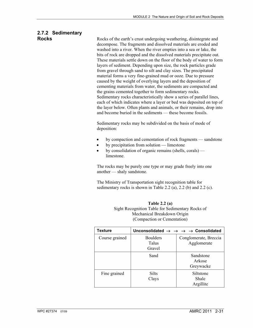
2.7.2 Sedimentary Rocks Rocks of the earth’s crust undergoing weathering, disintegrate and
decompose. The fragments and dissolved materials are eroded and washed into a river. When the river empties into a sea or lake, the bits of rock are dropped and the dissolved materials precipitate out. These materials settle down on the floor of the body of water to form layers of sediment. Depending upon size, the rock particles grade from gravel through sand to silt and clay sizes. The precipitated material forms a very fine-grained mud or ooze. Due to pressure caused by the weight of overlying layers and the deposition of cementing materials from water, the sediments are compacted and the grains cemented together to form sedimentary rocks. Sedimentary rocks characteristically show a series of parallel lines, each of which indicates where a layer or bed was deposited on top of the layer below. Often plants and animals, or their remains, drop into and become buried in the sediments — these become fossils. Sedimentary rocks may be subdivided on the basis of mode of deposition: by compaction and cementation of rock fragments — sandstone by precipitation from solution — limestone by consolidation of organic remains (shells, corals) —
limestone. The rocks may be purely one type or may grade freely into one another — shaly sandstone. The Ministry of Transportation sight recognition table for sedimentary rocks is shown in Table 2.2 (a), 2.2 (b) and 2.2 (c).
Table 2.2 (a) Sight Recognition Table for Sedimentary Rocks of
Mechanical Breakdown Origin (Compaction or Cementation)
Texture Unconsolidated Consolidated
Course grained Boulders Talus
Gravel
Conglomerate, Breccia Agglomerate
Sand Sandstone Arkose
Greywacke
Fine grained Silts Clays
Siltstone Shale
Argillite
MODULE 2 The Nature and Origin of Soil and Rock Deposits
WPC #27374 07/09 2-32 AMRC 2011
Figure 2.2 (b) (c) Sight Recognition Table for Sedimentary Rocks
A. Chemical Origin (Precipitation from Solution)
Chemical Precipitates Carbonates Silica Clay minerals
Limestone, Dolomite Chert (flint) Marl
Evaporation Products Gypsum, Anhydrite
B. Organic Origin (Consolidation of organic remains) Shells, Corals
Algae Diatoms Radiolaria Peat
Limestone, Dolomite Chalk Diatomite, Chert Coal
2.7.3 Metamorphic Rocks When any rock is changed from its original nature by the action of
heat, pressure or chemical action, it is said to be metamorphosed and is called a metamorphic rock. The original minerals may recrystallize to form a coarser-grained rock: change of limestone to marble. New minerals may be formed: formation of a garnet in schist. A foliated structure may be formed that allows the rock to split into leaves, flakes or sheets, and is caused by the growth of thin platy minerals, especially micas, with other minerals in parallel layers: a schist. Metamorphic rocks may form igneous sedimentary or other metamorphic rocks. The Ministry of Transportation sight recognition tables for metamorphic rocks are shown in Table 2.3 (a) and 2.3 (b).
Table 2.3 (a) Sight Recognition Table for Metamorphic Rocks
from Sedimentary Rocks
Metamorphic Rocks
Original Rocks Foliated Massive or poorly foliated
Sandstone Shale Schist Slate, Phyllite
Quartzite Hornfels
Limestone Schist, Gneiss Marble
MODULE 2 The Nature and Origin of Soil and Rock Deposits
WPC #27374 07/09 AMRC 2011 2-33
Figure 2.3 (b) Sight Recognition Table for Metamorphic Rocks from Igneous
Rocks
Metamorphic Rocks
Original Rocks Foliated Massive or poorly foliated
Granite, syenite diorite, gabbro Peridotites
Gneiss
Serpentine Soapstone
Rhyolite and Trachyte
Schists
Andesite and Basalt
Schists Greenstone
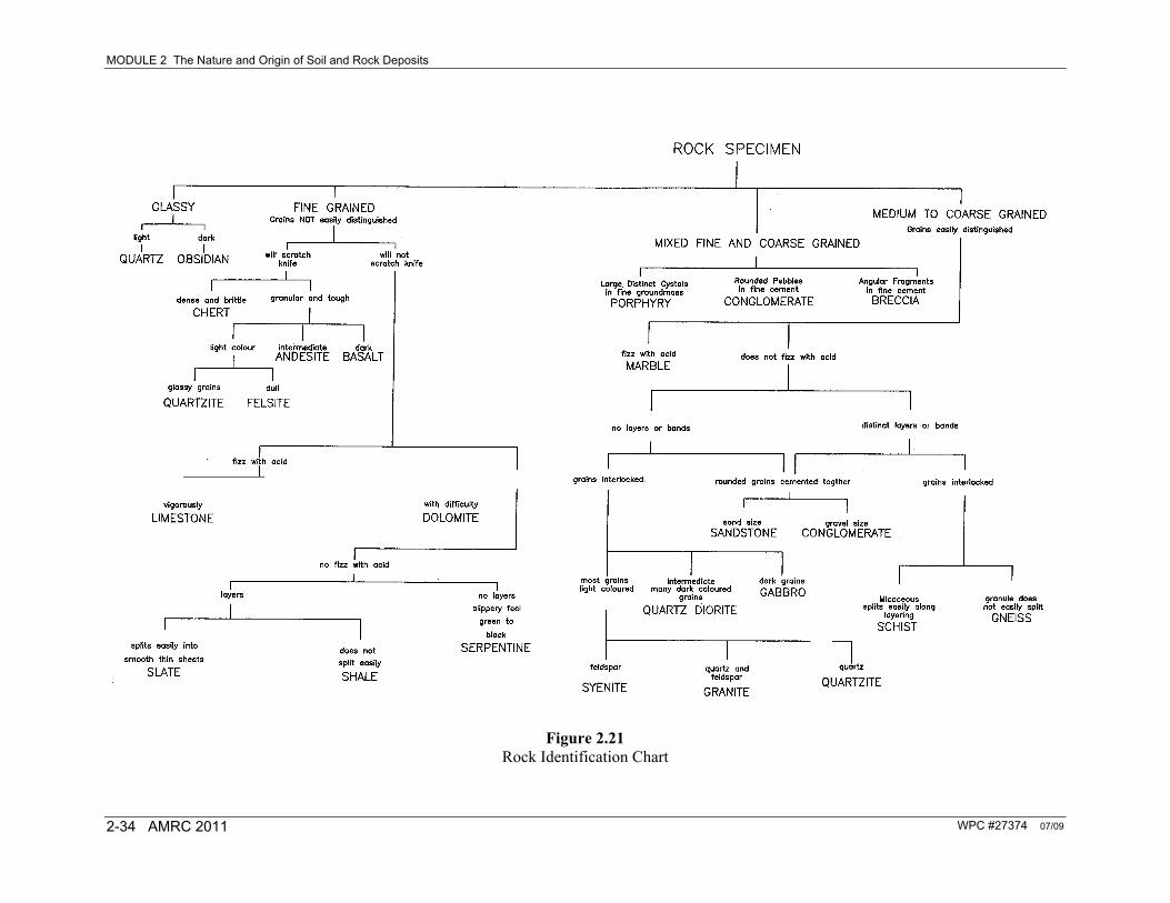
A summary of common rock types, which is a rock identification chart used by the Ministry of Transportation, is shown in Figure 2.21. This chart provides a relatively easy method of identification. For example: A rock identification could be made from the following observations and by reference to Figure 2.21. grains of the rock easily distinguished (coarse grained) the rock did not fizz when treated with acid the rock had distinct layers the grains were interlocked the rock split easily along the layering. According to Figure 2.21, this rock would be a schist. It is difficult to gain an appreciation of these various rock types without actually handling and examining specimens. Illustrations of a granite, a porphyry and a conglomerate are shown in Figures 2.22, 2.23 and 2.24. These examples illustrate some of the descriptions used in Figure 2.21.
MODULE 2 The Nature and Origin of Soil and Rock Deposits
WPC #27374 07/09 2-34 AMRC 2011
Figure 2.21 Rock Identification Chart
MODULE 2 The Nature and Origin of Soil and Rock Deposits
WPC #27374 07/09 AMRC 2011 2-35
Figure 2.22
Coarse Granite Grains Note the coarse grains in the granite: the large white (or pink) crystals are feldspar, the clear grains are quartz and the dark grains are iron rich minerals.
Figure 2.23
Porphyry
MODULE 2 The Nature and Origin of Soil and Rock Deposits
WPC #27374 07/09 2-36 AMRC 2011
Note the large white crystals of feldspar in a fine mass (the dark colour).
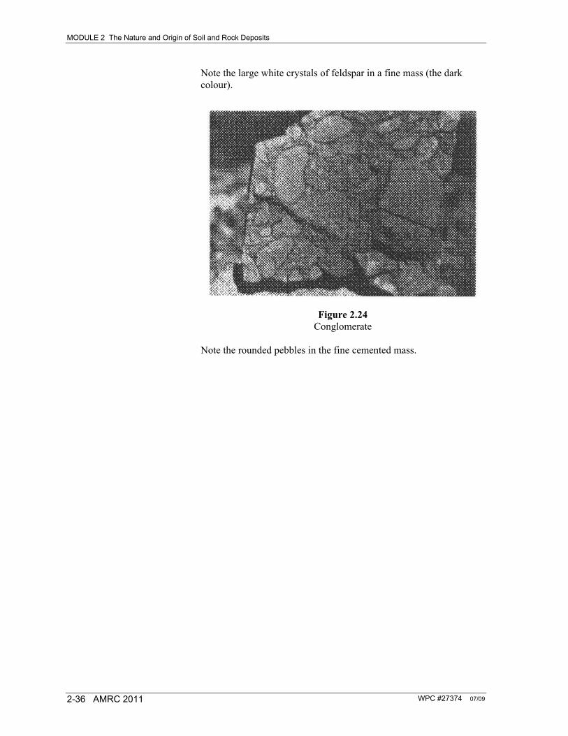
Figure 2.24
Conglomerate Note the rounded pebbles in the fine cemented mass.
WPC #27374 07/09 AMRC 2011 2-37
SECTION 2.8
Weathering of Rock
Reference was made earlier to the importance of the weathering action upon rocks. The action of weathering in producing residual soils is very important and the degree of weathering of rock has a considerable influence on the strength of the rock mass. Weathering processes in rocks may be: physical (also called “mechanical” or “disintegration”): may be
caused by heat induced expansion of the rock or by ice action in rock fractures
chemical: may be caused by the action of water dissolving the
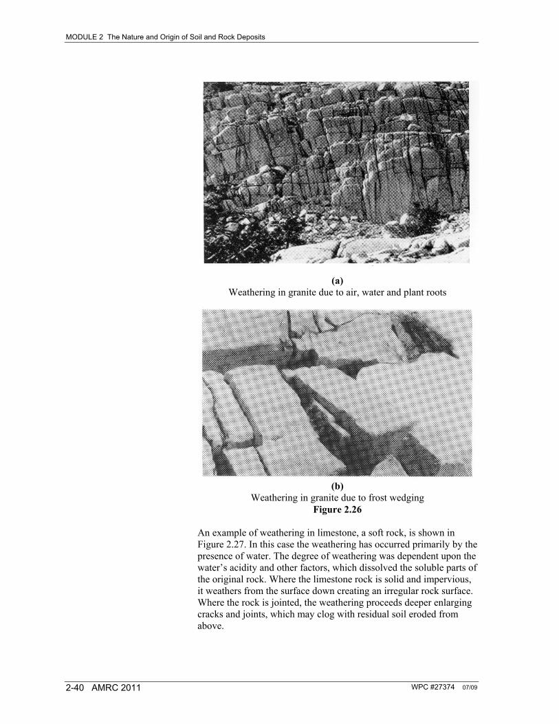
soluble parts of rock. Practically all weathering is chemical or a combination of physical and chemical weathering. Frost action is the most common example of physical weathering; it works by a combination of moisture movement and freezing expansion. Examples of two different types of weathering in granite are shown in Figures 2.26 (a) and (b). Figure 2.26 (a) shows a bedrock of granite, a hard rock, which is much fractured where weathering has been aided by the entry of water, air and plant roots into the fractures. Figure 2.26 (b) shows blocks of granite pushed apart by frost wedging. Mechanical Weathering Mechanical weathering, which is also called disintegration, is a process by which rock is broken down into smaller and smaller fragments as the result of the energy developed by external physical forces. For example, when water freezes inside a rock fissure, enough energy may develop to pry off individual pieces, or when a boulder is moved by gravity down a rocky slope, it may be shattered into smaller fragments. Note that in mechanical weathering the size of the material changes from large to small, but the composition of the material is unchanged. Changes in temperature, if rapid and great enough, will bring about slight mechanical weathering of rocks. For instance, in areas where bare rocks are exposed to the surface, forest or bush fires can generate enough heat to break up the rock. The rapid and violent heating of the exterior zone of the rock causes it to expand, and if the expansion is great enough, flakes and large fragments are split off.
MODULE 2 The Nature and Origin of Soil and Rock Deposits
WPC #27374 07/09 2-38 AMRC 2011
Frost is another effective mechanical weathering agent. When the temperature of water drops from 4° to 0°C, the volume increases by 9.2%. Water held in the cracks, joints and pore spaces of the rock can freeze and exert tremendous pressure on the interior of the rock. If freezing water is completely confined, pressures up to ten times greater than the tensile strength of the rock may be generated, splitting the rock. The dislodged fragments of mechanically weathered rocks are angular in shape and their size depends largely on the nature of the bedrock from which they have been displaced. Usually the fragments are only a few centimetres in size, but may reach a size of three metres. A deposit of large angular displaced fragments at the base of a cliff or steep slope is called talus or float (Figure 2.25).
Figure 2.25 Colluvial Deposit
Plants also play a role in mechanical weathering. The roots of trees and shrubs growing in rock crevices sometimes exert enough pressure to dislodge previously loosened fragments of rock, similar to the way tree roots heave and crack sidewalks and pavements. Agents such as running water, glacial ice, wind and ocean waves also help to reduce rock material into smaller and smaller fragments. The role of these mechanical weathering agents will be discussed further under transportation.
MODULE 2 The Nature and Origin of Soil and Rock Deposits
WPC #27374 07/09 AMRC 2011 2-39
Chemical Weathering Chemical weathering, sometimes called decomposition, is a more complex process than mechanical weathering. As previously mentioned, mechanical weathering merely breaks rock materials down into smaller and smaller particles without changing the composition. Chemical weathering, however, actually transforms the original material into a chemically different composition. Chemical weathering of the mineral, feldspar, for example, produces clay minerals, which have a different composition and different physical characteristics from those of the original feldspar. The size of individual particles of rock is an extremely important factor in chemical weathering because the substances can react chemically only when they come in contact with one another. The greater the surface area of a particle, the more susceptible it is to chemical attack. Take, for example, a pebble and grind it into a fine powder; the total exposed surface is greatly increased. As a result, the materials that make up the original pebble will undergo more rapid chemical weathering. The rate of chemical weathering is affected by other factors such as the composition of the original material. For example, a copper water pipe lasts longer than an iron water pipe because the copper weathers chemically more slowly than the iron. Climate also plays a key role in chemical weathering. Moisture, particularly when it is accompanied by warmth, speeds up the chemical weathering. Conversely, dryness and cold temperatures will slow down the chemical weathering processes. Finally, plants and animals contribute directly or indirectly to chemical weathering since their life processes produce oxygen, carbon dioxide and certain acids that enter into the chemical reaction with earth minerals. Limestones are subject to chemical weathering when coming in contact with water. Water will dissolve certain carbon compounds, therefore weathering the material in one location and under different circumstances precipitating the carbon compounds out of solution and depositing them in another location. No doubt you have visited or read about the large limestone caverns in various parts of the world which have been leached away by the dissolving of carbon compounds into the ground water system. This weathering is called carbonation. We also have oxidation as a chemical weathering agent. A good example of this is rust forming on steel. Many iron bearing minerals will be oxidized when exposed to the atmosphere. This is usually evident by a reddish coating on rocks. If the constituent minerals of the rock are changed by chemical attack, the resulting decomposition and weakening of the rock mass is referred to as “rotting” of the rock.
MODULE 2 The Nature and Origin of Soil and Rock Deposits
WPC #27374 07/09 2-40 AMRC 2011
(a)
Weathering in granite due to air, water and plant roots
(b)
Weathering in granite due to frost wedging Figure 2.26
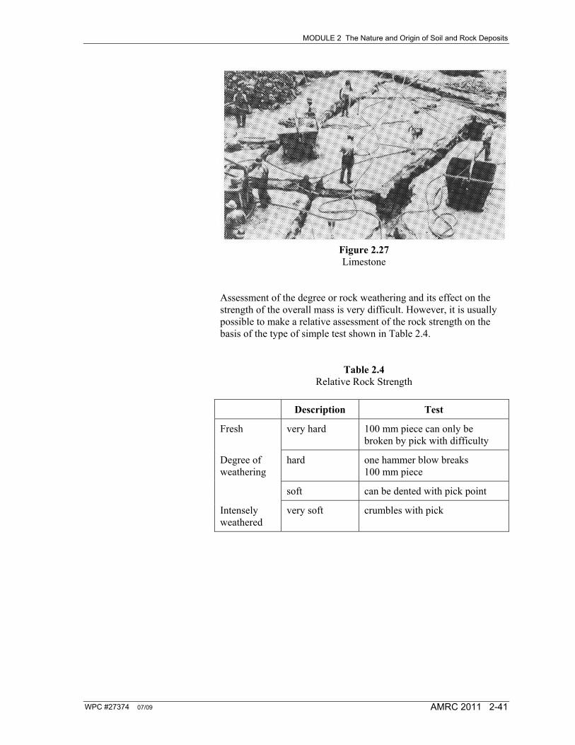
An example of weathering in limestone, a soft rock, is shown in Figure 2.27. In this case the weathering has occurred primarily by the presence of water. The degree of weathering was dependent upon the water’s acidity and other factors, which dissolved the soluble parts of the original rock. Where the limestone rock is solid and impervious, it weathers from the surface down creating an irregular rock surface. Where the rock is jointed, the weathering proceeds deeper enlarging cracks and joints, which may clog with residual soil eroded from above.
MODULE 2 The Nature and Origin of Soil and Rock Deposits
WPC #27374 07/09 AMRC 2011 2-41
Figure 2.27 Limestone
Assessment of the degree or rock weathering and its effect on the strength of the overall mass is very difficult. However, it is usually possible to make a relative assessment of the rock strength on the basis of the type of simple test shown in Table 2.4.
Table 2.4 Relative Rock Strength
Description Test
Fresh very hard 100 mm piece can only be broken by pick with difficulty
Degree of weathering
hard one hammer blow breaks 100 mm piece
soft can be dented with pick point
Intensely weathered
very soft crumbles with pick
MODULE 2 The Nature and Origin of Soil and Rock Deposits
WPC #27374 07/09 2-42 AMRC 2011
WPC #27374 07/09 AMRC 2011 2-43
SECTION 2.9
Subsurface Water in Rock
Water can seep into and through rock masses. The water may, in some rocks, exist mainly in the fractures. It circulates in the rock through these fractures, as illustrated in Figure 2.28.
Figure 2.28
Water Movement in Rock Fractures In the case of a permeable sandstone, the water can move directly through the rock (see Figure 2.29).
Figure 2.29 Water Movement through Permeable Rock
The existence of water in rock and the water pressures thus created play a significant role in the behaviour of rock structures such as road cuts.
MODULE 2 The Nature and Origin of Soil and Rock Deposits
WPC #27374 07/09 2-44 AMRC 2011
WPC #27374 07/09 AMRC 2011 2-45
SECTION 2.10
Self-Test
1. What is meant by the term geology and how does it differ from
the term geotechnical engineering?
2. What is a residual soil and how is it formed?
3. In this module, five descriptions concerning the origin and character of natural deposits are discussed. Name them.
4. What is soil creep and what is its importance in engineering?
5. State another name for subsurface water and explain what it is.
6. What is glacial till and where is it found?
7. Describe an end moraine, a drumlin and an esker.
8. What is meant by the term petrology and how is it different from petrography?
9. You are given a rock sample to identify. What factors or characteristics would you look at in order to do so?
10. Given the following facts about a rock sample, use Figure 2.21
(Rock Identification Chart used by the MoT) to identify the followings:
grains of the rock not easily distinguished will not be scratched with a knife does not fizz when treated with acid splits easily into thin, smooth sheets.
11. Describe the types of weathering on a rock formation that can
occur and explain what effect weathering has on the properties of rock.
MODULE 2 The Nature and Origin of Soil and Rock Deposits