Mineral Exploration and Fort Placement in Roman Britain By Richard Dibon-Smith “Britain yields gold, silver, and other metals, to make it worth conquering.” Tacitus (De Vita Agricolæ) 12.6 It has been common practice for historians of technology to interpret the colonial systems of the ancient world as little more than mining enterprises operated for the enrichment of the conquering country. Two examples of this approach are the works of Alexander Del Mar and Thomas Rickard. 1 Del Mar’s account, written in the late nineteenth century, and Rickard’s, in the 1930s, both describe military occupation and domination in essentially mineralogical terms, particularly when it comes to the Romans: “Spain was exploited to enrich the patricians; Britain was exploited to enrich the emperors; after which it was abandoned to six centuries of anarchy and decay,” according to Del Mar (p. 107). Unfortunately Del Mar’s disdain for citing specific evidence considerably weakens his argument. His claim that “the gold quartz mines opened by the Romans [in Britain] are too numerous to mention” (p. 113) is not only unconvincing but still—over one hundred years later—unsubstantiated. For Rickard’s part, he bases his entire claim from the single brief comment by Tacitus quoted above. While Rickard presents good evidence to show that Britain first came under the notice of Mediterranean cultures because of her store of minerals (mostly tin) neither Rickard nor Del Mar nor anyone else until very recently has been very successful in demonstrating anything more than rather casual links between Roman military occupation and mineral exploitation, whether in Britain or anywhere else. A considerable amount of archaeological activity has occurred since the 1950s and is continuing down to the present, providing much hard evidence not previously available. Concerning the Romans in Spain a number of studies beginning in the 1970s have studied in detail the military occupation in both the north and the south; 2 the general results of these extensive surveys have elicited from R. F. J. Jones the remark that “the army’s relationship with mining may well repay further attention, both in Spain and in other provinces.” [(1976)62] In Britain the extent of early Roman forts and their geographical placement are now generally known, not always with certainty but with growing confidence. Archaeological work done in Wales has sharpened the focus of our view on both pre-Flavian and Flavian Wales, while in Scotland important discoveries are being made yearly. ______________________________________________________________________ * I owe a great debt of thanks to Professor S. S. Frere of the Institute of Archaeology, University of Oxford, for his many comments and corrections to previous drafts of this paper.
Transcript
Mineral Exploration and Fort Placement in Roman Britain
By Richard Dibon-Smith
“Britain yields gold, silver, and other metals, to make it worth conquering.”
Tacitus (De Vita Agricolæ) 12.6
It has been common practice for historians of technology to interpret the colonial
systems of the ancient world as little more than mining enterprises operated for the
enrichment of the conquering country. Two examples of this approach are the works
of Alexander Del Mar and Thomas Rickard.1 Del Mar’s account, written in the late
nineteenth century, and Rickard’s, in the 1930s, both describe military occupation and
domination in essentially mineralogical terms, particularly when it comes to the
Romans: “Spain was exploited to enrich the patricians; Britain was exploited to enrich
the emperors; after which it was abandoned to six centuries of anarchy and decay,”
according to Del Mar (p. 107).
Unfortunately Del Mar’s disdain for citing specific evidence considerably weakens
his argument. His claim that “the gold quartz mines opened by the Romans [in Britain]
are too numerous to mention” (p. 113) is not only unconvincing but still—over one
hundred years later—unsubstantiated.
For Rickard’s part, he bases his entire claim from the single brief comment by
Tacitus quoted above. While Rickard presents good evidence to show that Britain first
came under the notice of Mediterranean cultures because of her store of minerals
(mostly tin) neither Rickard nor Del Mar nor anyone else until very recently has been
very successful in demonstrating anything more than rather casual links between
Roman military occupation and mineral exploitation, whether in Britain or anywhere
else.
A considerable amount of archaeological activity has occurred since the 1950s and
is continuing down to the present, providing much hard evidence not previously
available. Concerning the Romans in Spain a number of studies beginning in the 1970s
have studied in detail the military occupation in both the north and the south;2 the
general results of these extensive surveys have elicited from R. F. J. Jones the remark
that “the army’s relationship with mining may well repay further attention, both in
Spain and in other provinces.” [(1976)62]
In Britain the extent of early Roman forts and their geographical placement are now
generally known, not always with certainty but with growing confidence.
Archaeological work done in Wales has sharpened the focus of our view on both
pre-Flavian and Flavian Wales, while in Scotland important discoveries are being
made yearly. ______________________________________________________________________ * I owe a great debt of thanks to Professor S. S. Frere of the Institute of Archaeology, University of Oxford, for his many comments and corrections to previous drafts of this paper.
Based on the most recent excavations, coupled with some historical considerations,
the present paper attempts to look at the Roman presence in Britain from a geological
vantage, specifically to distinguish if any links may have existed between the military
occupation and mining exploration. Note that ‘exploration’ and not ‘exploitation’ is
studied, for in Britain it would soon become apparent that the mining of gold and silver
would not be as immediately successful as the contemporary Spanish mines. For this
reason I will suggest that Roman activities in Britain necessarily had to have an
explorational component associated with the military presence if they hoped to involve
themselves in any kind of metallurgical activities of any significance. I am not concerned
with the Roman system of mine control and its day-to-day operations, but wish only to
investigate the external evidence which might point toward an interest in the exploration
of precious minerals.
Britain was always thought of in antiquity as brimming over with precious metals.
Legends concerning the supposed wealth of the island were alive long before the
Claudian venture. Strabo is the first known writer to state that gold could be found in
Britain.3
Cicero, however, had claimed some years earlier that neither gold nor silver
were to be found there,4
based on a hasty appraisal of Caesar who, himself, had written
that tin could be found inland and iron on the coast, but copper had to be imported.5
Yet
rumours of wealth would not die, abetted by writers such as Solinus who said “Britain
hath many rich veynes on all sides”6
long after the Romans knew otherwise. Solinus had
a fertile imagination, stimulated by Pliny’s Natural History. Pliny, writing at or just
before the time that the Welsh gold mines were being worked, only mentioned its
plentiful lead supply [NH xxxiv, 17, 164]. Clearly, to obtain a better view of Roman
mining activities in Britain other means apart from analysing the gleanings collected
from classical literature must be developed.
A useful back-drop to a discussion of Roman interest in Britain’s minerals will be a
brief review of her previous campaigns of occupation. In 25 BC three legions under
Augustus finally defeated the Asturians and Cantabri of the northwest of Spain after a
two-year struggle. Following this conquest scattered resistance was recorded in 24 BC,
22 BC, 19 BC, and finally in 16 BC, after which time Roman pacification seems to have
settled in. The Spanish campaign can be summarized as a difficult defeat of a band of
wild hill-people unanxious to make alliance with Rome, the quick establishment of a
series of forts and roads throughout the territories of the subjugated tribes, followed by
the just as rapid pacification of these people. Alongside this military presence blossomed
forth the enormously productive gold mines of north-western Spain, providing Rome
with an annual take—if Pliny’s figures are accurate—of nearly ten tons of refined gold
[NH xxxiii, 4, 78]. It is obvious that once in Spain, Rome was happy to exploit her
minerals to the fullest.
After Spain Rome’s attention was drawn to the Rhineland. From 16 BC to AD 43 she
built up a series of fortresses along the left bank of the Rhine centred around Neuss, with
a second area of concentration around the confluence of the Rhine and the Neckar, at
66 New Ideas About the Past: Seven Essays in Cultural History
Mainz.7
These two specific geographical areas were to claim much of Rome’s attention
for the next sixty years, both militarily and metallurgically, for silver, lead, copper, and
in particular iron were all extensively mined. Gold, however, seems to have eluded the
Romans, at least in large quantities, for Tacitus states that none was to be found in
Germany [Germ. 5]. Then in 43 the decision was made by Claudius to invade Britain.
Immediately after the conquest the iron-rich areas of Kent and Sussex were exploited
and within six years the Mendip mines further west began producing lead and
cupellated silver.8
The Forest of Dean would soon provide a great deal of haematite,
and the promise of yet richer finds was just over the Welsh hills to the west.
The speed and thoroughness with which the Romans went about smelting iron and
producing lead bars in Britain lends itself to the belief that Roman exploitation of
minerals was far from casual. Although silver, copper, iron and lead were all important
to the Roman economy, the present paper will confine itself to the possibility that
Roman ‘mining engineers’ or other specialists were actively engaged in the
prospecting for gold. Based on the great interest the Romans gave to this mineral while
in Spain, this initial supposition at least serves as a working hypothesis.
What steps were involved in the search for precious minerals, specifically gold?
Besides the requisite of mountainous—or at least hilly—country, one authority
suggests that one should look for certain indicator rocks that are quite often associated
with gold deposits: “the outward features mostly looked for are granitic, porphyritic,
quartzose or clay-slate formations, these being most generally (though not exclusively)
auriferous rocks. The first step usually taken, after roughly noting the character of the
rocks occurring in the district, is to follow up the water channels. Specimens of all the
rocks met with in the course of the stream are sure to be found in its bed, washed and
cleaned so as to be readily recognisable.”9
A second authority, in discussing placer mines, considers that ‘ideal conditions’ are
found in “valleys leading off the drainage from mountains with auriferous lodes”.
Furthermore, “the coarsest gold occurs usually at the heads of ravines or gulches,
unless the gradient of the stream is too great. ... Rich deposits are seldom opposite the
mouths of tributary streams because the increased volume of water and greater velocity
of the current tend to sweep any material onward.”10
Roman prospectors were known to take into account both the colour of the earth
and the lay of the land when searching for gold and other minerals.11
For example,
Pliny recounts that in Spain auriferous earth was called segullum. This was washed and
examined to determine the value of the find. As Rankin instructed above, the
Romans—as well as miners of even greater antiquity—sifted through the alluvium for
indications of gold-bearing rock.
In addition to alluvium mining, Romans were adept in mining gold from hard-rock
and from placers.12
To this end their technological achievements in Spain included the
development of the water wheel and the so-called Archimedean Screw to get rid of
unwanted water in mine shafts and the construction of sophisticated aqueducts over long
distances to transport water necessary in mining operations. It also appears that on at
least one occasion they were able to follow a vein across a complex fault.13
It is not
known just to what extent Romans distinguished between various sorts of
Mineral Exploration and Fort Placement in Roman Britain 67
mineral-bearing rock, but the experience of Spain would not have failed to advance their
appreciation for the differences between auriferous and non-auriferous rock formations.
This appreciation would most likely be seen in attention given not only to streams
flowing out of mountainous regions, but to terrain where clearly discernible changes in
the kinds of rock present are evident, for it is at such ‘boundaries’ that minerals are most
likely to become exposed.
In Britain it would be immediately evident that if one wished to mine for gold one
would have to study the hills of Wales and of Scotland. It is therefore the detailed study
of these two areas that will indicate if the Roman invasion of Britain had a mineral-
exploration component connected to it.
Pre-Flavian Wales
Much of the time between the invasion of Claudius and the onset of the governorship
of Agricola was spent subduing the Celtic tribes of Wales, specifically the Silures and
the Ordovices. Indeed, between the years 48 and 78 Roman legions were continually
harassed by revolts and engaged in counter-offensives, if the account of Tacitus is
accurate.14
Thus the Silures, led by Caratacus, harass Roman troops from 48 to 51, when
the Silurian leader is finally captured. From 52 to 58 the tribes of Wales are slowly
subjugated, first the Silures then the Ordovices. But after the Boudicean rebellion of 61
Nero hesitates to further involve himself in the province.15
After his death the Roman
civil war of 68-9 prevents further incursions into Wales until the ascendancy of
Vespasian to the throne. Having commanded the II Augusta legion under Claudius,
Vespasian was well acquainted with Britain; he appoints Julius Frontinus as governor in
74, and in Wales a markedly fervent building programme is immediately undertaken,
which will be later discussed.
A brief review of pre-Flavian military occupation of Wales might help set the
circumstances under which the forts of Frontinus and Agricola would be later built.
Figure 1 notes the Roman sites known—or assumed at this point—to have been
constructed in Wales from AD c50 to c61: the eastern perimeter is covered by the
legionary fortresses of Gloucester and Wroxeter as well as the fort of Whitchurch, while
in the interior military presence of varying duration was established at Cardiff, Usk,
Abergavenny, Llandovery, Clyro, Jay Lane, Llwyn-y-Brain, Rhyn Park, Llanfor, and
possibly Pennal.16
Thus the geographical disposition of the pre-Flavian forts shows extensive activity in
the land of the Silures as well as into the north, home of the Ordovices. In fact the forts
listed above are rather evenly spaced throughout the interior of Wales, with no area
receiving more attention than another, excepting the extreme southwest and northwest
corners which are ignored. Disregarding the obvious military concern that would have
influenced the positioning of the pre-Flavian forts, one may ask if other
concerns—specifically mineralogical—might have played a part in their placement.
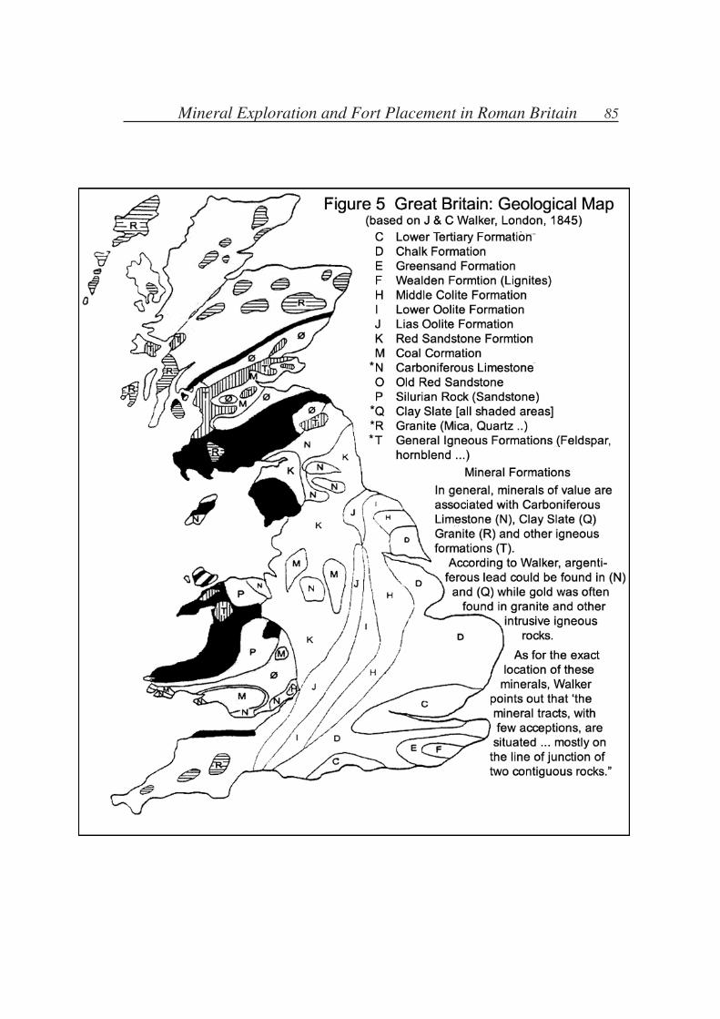
Figure 2 shows the geology of the country in relation to these early forts. Speaking
first of the three eastern forts (A, B, C) it is seen that all three are on the western edge of
the Red Sandstone and Oolite formations typical to the interior of England. Moreover A-B
corresponds well with the boundary created by the Old Red Sandstone of Wales. One
68 New Ideas About the Past: Seven Essays in Cultural History
could say that forts A, B, and C delimit the strictly Welsh rocks from the totally
different formations found in England.
Turning to the nine interior forts, it is apparent that each is in close proximity to the
geological junction of two or more rock formations. Cardiff (1) sits on the
minerally-rich Carboniferous Limestone band that wraps itself around the Coal
Formations of Glamorganshire, while Usk (2) and Abergavenny (3) are approximately
eight and five kilometres respectively from the same narrow band.17
Farther up the Usk
Llandovery (4) is on the border of the significant Clay Slate formation that covers all
of the west-central mining area. It should be noted however that this site has not been
positively identified as pre-Flavian. Clyro (5) is on the west bank of the Wye, about
three km east of the border of Old Red Sandstone and Silurian Rock; Jay Lane (6) sits
just inside the same border, about five km west of the junction. (This site too is
problematic; it may not have been occupied until c75.) Llwyn-y-Brain (7) is nearly
astride the junction of Silurian Rock and Clay Slate. Pennal (8) and Llandor (9) are on
the Clay Slate near its border with the intrusive igneous formations that contain the
Dolgelly gold belt. Finally Rhyn Park (10) is located just where the river Ceiriog, a
tributary of the Dee, pours out of the hills. This fort lies in an extremely strategic area
where several important formations meet.
During the excavation of Rhyn Park it was noted that the site consisted of two
occupational phases, one a 46 acre site, the other a 14 acre fort. Between these stages
of occupation a series of ovens were built.18
Although neither the number of ovens,
nor their apparent function, is given in the above account, it is not too far-fetched to
suggest—based on Kelly’s study of metal-working in north Wales19
—that they may
have been smelting ovens used to perform assays of the surrounding countryside.20
Several other forts on the above list are of particular interest. Llwyn-y-Brain seems
to have been replaced rather quickly by another fort, Caersws; this was to remain in
use until the late third century. Such duration may relate to a military function; it may
also relate to its proximity to the minerally-abundant Plynlimon range just to the west.
As for Llanfor, which was later replaced by Caer Gai, and Pennal, these two forts
border on the Dolgelly gold belt of the ‘intrusive igneous formation’ (T). In fact, all of
the gold that Wales would yield is contained within the area controlled by the western
forts of Llandovery, Llwyn-y-Brain, and Llanfor. To the east and southeast of Pennal,
the western slope of Plynlimon contained vast quantities of copper and lead.
An objection might be raised concerning the ability of fairly primitive prospectors
to differentiate between large areas of various rock formations. To dispel such a notion,
I quote the words of the first investigator of Welsh geology, Sir Roderick Murchison:
“Let those who doubt of the practicability of drawing a well-defined boundary line,
between the Silurian and Old Red Systems, place themselves up on this narrow ridge
or grey coloured rocks [near Brecon], and contrasting their colour and external features
with the surrounding expanse of red lands, they will, at once, admit that no two
formations can be more neatly separated. This observation is indeed of general
application and admits of no modification, for it may truly be said that the physical
demarcation is clear in all districts where the surface is free from drifted materials.”21
Mineral Exploration and Fort Placement in Roman Britain 69
Murchison spoke of the ‘Silurian’ system; this is what I have called Clay Slate, a term
no longer used, but useful in that it conforms with Walker’s map [Fig. 2]22
as well as
being listed by Rankin as an auriferous-bearing rock.23
Murchison discovered in 1831
that this formation was older than the Old Red Sandstone and gave it the name of the
ancient Welsh tribe; another layer, even older, was later named Ordovician. These names
are still used to refer to rock formations of a certain age; I continue to use the name Clay
Slate in that it emphasizes the composition of the rocks, not their age.
Flavian Wales
Thus, even before the arrival of Frontinus in Wales, the ground may have been well
surveyed, potential mining country divided from barren country, and ores perhaps
already being worked in some areas.24
With the arrival of Frontinus, the building of forts
throughout Wales increased rapidly. In the north Rhyn Park was soon abandoned, while
Pennal, if not earlier, was now founded. And as the legionary fortress of Chester was
being built, in the south Caerleon was replacing Usk. Figure 3 shows the full range of
building activity throughout the period of Frontinus and his immediate successor
Agricola. It is difficult to separate the two governors’ work, the building campaign of
Agricola complements the achievements of his predecessor. Only recently is the northern
work of Frontinus being appreciated; mention has been made of his founding of Chester.
In addition, the forts of Tomen-y-Mur, Caer Gai, and even Caerhun show possibilities of
a Frontinian origin. At Caer Gai occupation seems to have lasted from c75/80 to c120.
Caerhun was of greater importance; located (like Chester, Caerleon, Carmarthen, and
Caernarvon) near the upper tidal limit of its river, it was an invaluable sea-port capable
of handling vessels of about 100 ton capacity.25
In addition to its sea-port facilities
Caerhun linked by road the fort of Tomen-y-Mur and points south.
Tomen-y-Mur, the third of these possible Frontinian forts, holds far the greatest
promise for mineral exploitation and possibly the key to occupation of the other two just
mentioned. There is no direct evidence to suggest that the Romans actively mined the
extensive Dolgelly gold belt west of the Mawddach river, just south of Tomen-y-Mur.
Nor is there any reason to presume that they were ignorant of its existence, for the
auriferous quartz veins were quite visible to the naked eye.26
Placement of the Phase Two forts (i.e., Early Flavian) in regard to geological
boundaries is presented in Figure 4. Of the twenty-six Phase Two forts six are sea-ports,
communication centres and/or legionary fortresses [11, 17, 20, 34, 35, 37], six are
situated directly on a geological boundary [15, 21, 22, 24, 25, 31] and six more are either
placed near the Carboniferous Limestone belt that divides the Coal Formations of
Glamorganshire from the Red Sandstone of the north [16, 18, 19] or form part of the road
that leads through this area to Brecon [12, 13, 14]. Brecon itself, while resting atop a
geological boundary, is also the communications ‘hub’ throughout the southern
mountain ranges.27
Of the eight remaining forts, four form a straight line between the gold mines of
Dolaucothi and the gold outcroppings south of Tomen-y-Mur [26, 27, 28, 29] and three
more are associated with the Tomen-y-Mur site itself [32, 33, 36]. Only one fort seems
to be randomly placed: Forden Gaer (23). Concerning this site, Figure 4 may offer a
70 New Ideas About the Past: Seven Essays in Cultural History
possible explanation, for it is strategically located between the important copper, lead,
and silver deposits of central Wales, and Kelly includes this site as one of the earliest
iron ore producers in north Wales.28
The Dolaucothi gold mines are of course the most spectacular mining achievement
of the Romans in Britain. It was commonly thought that this gold was discovered by
the Romans themselves, however excavations in 1969 uncovered the existence of a
pre-Roman settlement associated with an exposed outcrop.29
This settlement would
have come under rapid control by the Roman legions, who would have then brought
all their expertise into play and developed heretofore inaccessible or unknown veins.
At present the earliest known Roman mining activities in this area are dated at c75.30
An increased appreciation for Roman mining technology has already emerged from
the study of Dolaucothi.31
The system of aqueducts, coupled with the hushing and
hydraulic operations, shows an affinity with Spanish mines, as does the use of water
wheels to eliminate excess flooding. Dolaucothi was to become the only known Roman
gold mine in Britain; for Rome, it must have represented the first of what would have
seemed the promised bonanza, stretching from the hills of Wales to the Highlands. This
impression of impending wealth would have received an added push with the discovery
of the Dolgelly gold belt in north Wales. The proximity of Caer Gai (32) and
Tomen-y-Mur (33) would seem to make this point, especially as the Roman road
coming up from the south forks on the southern edge of this gold belt, skirting both
west and east of the region.32
If gold was perhaps of primary interest, other minerals would be actively worked
as they were either discovered or expropriated. Anglesey, Carnarvonshire, Flintshire,
Shropshire and the slopes of Plynlimon provided abundant copper, lead, and silver.33
By the time Agricola headed north the mining activities of Wales would have been in
full production.
Scottish Lowlands
In the Scottish Lowlands a system of six forts ranged from east to west [Figure
6:1-6]. Below this line are found all of the remaining forts in the Lowlands built by
Agricola until he reached the Clyde-Forth area.34
Again the comparison is made with
geological boundaries [Figure 7]; it is found here that the forts only conform
approximately with the boundaries, which are themselves much less clear-cut than in
Wales.35
Nevertheless it is seen that all but two are found on the Clay Slate, often near
its edge. Moreover in addition to the largest single deposit of copper ore in Britain, the
central region is also well known for its gold mines, worked in the Middle Ages, at
Leadhills and Wanlockhead [Figure 8]. Long thought to have been discovered in the
twelfth and thirteenth centuries,36
the possibility has been raised that Romans worked
some of the mines, particularly at Wanlockhead, where stone tools have been attributed
tentatively to Roman miners or even pre-Roman.37
Crawford was an important communications centre; roads coming from Nithsdale
and Annandale crossed here. At Crawford has been discovered a crucible fragment
showing that a copper-zinc alloy was being smelted during the Antonine
re-occupation.38
Nothing has yet been found to suggest that Crawford served as a
Mineral Exploration and Fort Placement in Roman Britain 71
smelting centre in Agricolan times. Dalswinton, south of Crawford in Nithsdale, was of
some importance as well; two separate phases of Flavian activity have been discovered,
each with two forts.39
If Roman occupational policy called for the immediate exploitation of all useful
minerals, while any mines being worked by natives would be confiscated, other locations
of known gold deposits would also be investigated, using their more advanced mining
technology. In this regard, the work of a seventeenth century prospector and silver refiner
will become useful. Stephen Atkinson40
wrote a short treatise in 1619 called The
Discoverie and Historie of the Gold Mynes in Scotland. In it every location in Scotland
known to have contained gold was listed (his Appendices I-III). It is apparent now that
the quantity of gold that the quantity of gold that was realised from these areas was
insufficient for industrial exploitation.41
Nevertheless the mere presence of auriferous
outcrops and the occasional nuggets found along the edges of the burns were persistently
encouraging signs for any prospector, and grants were often made throughout the Middle
Ages for mineral exploitation of these regions. Along with the known Roman forts and
mineral deposits, Figure 8 displays as many of Atkinson’s sites throughout the Lowlands
as can be located. Of the eighteen sites south of the Clyde-Forth line, only two—G15 and
G16—lie relatively isolated.42
On the other hand, throughout the Lowlands the gold
locations often duplicate the distribution of Roman forts: G1, G2, G4, G5, G6, G10, G11,
G14, and G17 are all close to forts.
Of the remaining Lowland gold sites listed by Atkinson G19 and G20 are found in
Fife, between Ardoch and the north coast of the Firth of Forth, in a large copper deposit.
A second list of gold sites was compiled by John Hunter in 1884.43
Hunter listed a
series of eighteen specific locations, all within a rectangle measuring approximately 40
by 15 km, centred on Leadhills-Wanlockhead. Of these eighteen, five are noted in Figure
8.
It should be emphasized that there is no evidence of Roman activity in any of the sites
of the Lowlands with the possible exception of Wanlockhead already mentioned.44
This
is not surprising in view of the fact that most of the sites enumerated by Atkinson and
Hunter did not prove workable and represented only the occasional alluvial find or a thin
and difficult vein. On the other hand, many Lowland sites do show evidence of
first-century iron smelting: Manning has observed that a great number of iron-work
hoards have come from military sites.45
In other words, we have evidence here that a
branch of the army was indeed active in metallurgical refining in Scotland, just as we
found in Wales.
It probably took the Romans a year to assess the worth of their discoveries, possibly
the year that Agricola ‘consolidated’ his lowland holdings, AD 81. During this time the
Romans spread out into Galloway and Ayrshire and perhaps built the Gask Ridge. This
system of forts and watch towers stretches northwest of the Firth of Forth at Ardoch to
the Firth of Tay at Bertha, enclosing the large copper deposits found on the Fife peninsula
[Figure 8].
It is perhaps significant that no mineral deposits in the Lowlands are to be found
outside the Agricolan limits set by the Clyde-Forth line and the Gask Ridge in the
72 New Ideas About the Past: Seven Essays in Cultural History
northern region, just as every gold site in the southern Lowlands is found enclosed
within the tight line formed by forts 1-6.
Scottish Highlands
Just north of this Lowland occupation another strip of Clay Slate was located,
following the mountains in a north-easterly direction, beginning at the western edge of
the Firth of Clyde [Figure 9]. Agricola constructed forts along the southern edge of this
strip, at Drumquhassle, Menteith, Bochastle, Dalginross, Fendoch, Cardean, and
Stracathro, and a legionary fortress at Inchtuthil, on the Tay, the largest of the rivers
flowing out of the mountains to the north.
If the Clay Slate was meant to be an indicator of auriferous deposits, Agricola was
bound to be disappointed; this time the Clay Slate was deceptive.46
If there was any
gold in the Highland mountains, its beds did not give onto the southern plains. Inchtuthil
was closed before it was completed. But before this happened a line of camps was
planted further north.47
The thin strip of ‘clay slate’ disappears into the North Sea near Stonehaven. North
of this point a line of large camps was built, at Raedykes on a small stream five
kilometres from the coast, at Normandykes on the Dee, Kintore on the Don, Durno on
the Urie, Ythan Wells at the source of the Ythan river, and Muiryfold on a small
tributary of the Deveron. Two smaller camps, Auchenhove (near Muiryfold) and Bellie
(near the mouth of the Spey), were also built.
Of particular importance in this group is the size of the middle camp, Durno. Only
discovered in 1975, this camp is the largest of all Roman camps north of the Antonine
Wall, about 144 acres.48
At the time of its discovery, Professor St Joseph tentatively
suggested that the camp’s size was a clue to the site of the famous battle at Mons
Graupius and he pointed out the nearby mountain range known as Bennachie as
possibly Mons Graupius itself. Further exploration revealed six hill-forts “or fortified
settlements ... (a remarkable concentration in this part of Aberdeenshire).”49
These
hill-forts are Mither Tap, Dunnideer, Pittodrie, Barmkyn of North Keig, Bruce’s Camp
and Tillymuick. St Joseph identified these settlements as Caledonian and concluded
that here indeed at Bennachie was fought the battle of Mons Graupius. From the point
of view of the present argument, additional evidence will be presented to strengthen
the argument that the battle was fought at least in the vicinity of Bennachie.
I have been using Stephen Atkinsons’s seventeenth century account of reported
gold deposits in Scotland to hypothesize a Roman gold-prospecting mission. It has
been evident that the Romans showed considerable interest in those parts of Scotland
where the highest concentration of gold deposits had been reported (i.e. the Nithsdale-
Annandale region). Concerning the Highlands and its purported store of precious
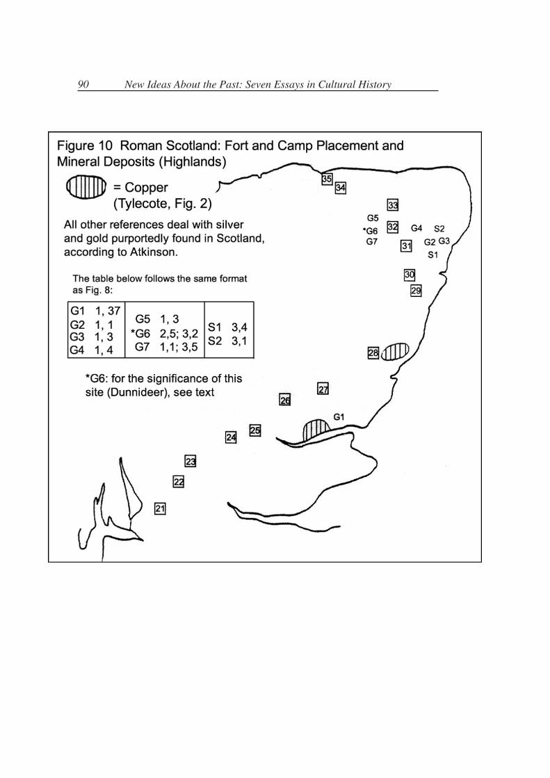
minerals, Atkinson indicated the existence of seven gold bearing areas and two silver
[Figure 10]. The gold was centred in two locations, one just north of Aberdeen, the
other to the west of that city. Atkinson mentioned this last location twice, first in
Appendix II, 5: “A place called Dumdeer is famous for Gold,”50
then in Appendix III,
2: “There is gold to be found in several places about Dumdeer, beyond Aberdeen
several miles.”51
The name Dumdeer is not found on current maps. Cochran-Patrick,
Mineral Exploration and Fort Placement in Roman Britain 73
who reproduced the Atkinson appendices in his own work, used a different spelling,
under which the area was at that time apparently known: Dunideer.52
Dunnideer is, of
course, one of the six hill-forts named by St Joseph.
While Bennachie may deserve first consideration, other sites could also claim the
right to be critically examined, such as Mither Tap, the highest of the Bennachie summits,
with an extensive view, or Dunnideer, only half as high, but with a clear view to the flatter
lands east all the way to the coast.
Professor St Joseph makes the observation that the battle of Mons Graupius, as
fought—he believes—at Bennachie, resembles in some ways the other outstanding battle
described in Tacitus, that of Caratacus in AD 51 at some uncertain locale in Wales.53
The
parallel deserves some attention from the present perspective, for if our conclusions are
correct, the two battles were fought for the same purpose. St Joseph suggests that
Caersws served as the locale of the Welsh confrontation. We have seen that this fort was
one of the earliest of the Welsh forts, replacing an even earlier fort, and was strategically
located in the centre of the principal mining region in Wales. The Scottish situation is
slightly different; there was no widespread mining done for the simple reason that
precious minerals are not found in abundance in either the Highlands or the Lowlands.
However evidence has been given that shows that the only Highland area known to have
some reputation for precious minerals is in Aberdeenshire, with Durno at the centre of
this region.
Subsequent events have been difficult to interpret. First, Agricola is ‘recalled’, hustled
into Rome during the dead of night ‘to avoid the crowds’, then curiously put out to
pasture. Never again did the Roman general receive a command, though only 44 years
old and, one would have thought, at the height of his career. All this history is habitually
dispensed with by the explanation given by Tacitus: Domitian was jealous of the feats of
Agricola and could not abide the thought that anyone might become more popular than
himself.54
Then the Highlands are abandoned altogether—the victory over north Britain
that Rome had so long desired is sacrificed to more pressing needs on the German border.
The story is over-familiar.
Many details in this sequence of events leave logical gaps not easily bridged. One
would think, for instance, that victory over the fierce Caledonians would be followed by
street dancing and Colosseum games. Instead it was a night-time home-coming followed
by an early retirement. That Agricola should have been recalled after Mons Graupius is
not surprising; he had already served almost double the normal time. (One will recall that
his extension came during the Lowland occupation.) But his subsequent treatment
borders on the humiliating. That Domitian was jealous of a general who by all accounts
fulfilled his assignment does not make much sense; he himself had just returned from
campaigning in Germany, a home-coming that was celebrated with Roman games and
the addition of ‘Germanicus’ to his own name. It was not a time to take jealous
vengeance. Nor can one blame Domitian’s actions against Agricola on the ‘reign of
terror’ for which the emperor is mostly remembered. This did not begin until around
89-90. In fact by 84-5 Domitian was very popular with the army, having raised its pay by
one-third in 84. The army would remain faithful to Domitian to the end.
74 New Ideas About the Past: Seven Essays in Cultural History
Most, if not all, of these difficulties disappear when we interpret the actions of
Domitian and Agricola in light of the present evidence. One must not overlook the fact
that this emperor had vastly over-spent both on Roman buildings and on his own lavish
dwellings. This, along with the added expense that a large well-paid army incurred,
nearly led the empire into bankruptcy. Additional sources of gold and silver were to be
an increasingly pressing problem for Domitian and for his successors; Agricola would not
be able to even duplicate the Dolaucothi discovery made by his predecessor. While it
may be premature at this point to consider the Roman army as nothing more than
advance men for the mining engineers and labourers who would follow in their wake,
it would equally seem rash to ignore the relationship throughout Roman history
between military and mining activities. G. D. B. Jones makes the point when he
remarks that the Dolaucothi mines were being shut down just as “the far greater bullion
resources of Dacia were first being tapped.”55
Objections of a literary and of an artifactual nature may be voiced over the above
argument. First, it can be claimed that there is very little evidence in classical literature
to suggest that mining was of such capital importance that it influenced invasion and
occupation policies. Secondly, no artifact whatsoever has ever been found linking any
of the Scottish Roman fort sites directly to gold mining. Nor have any shafts, adits,
aqueducts, nor any other gold-mining activities contributable to the Romans ever been
found in Scotland, either in the Lowlands or in the Highlands, and specifically at
Bennachie or Dunnideer.
As for the literary silence on mining activities, it was not exceptional for Roman
historians to ignore the lesser exciting aspects of colonial life when writing eulogies of
Imperial rulers. Roman historians were much less interested in objective studies of
policy making, of social structures, of economic activities, than they were in the
glorification of their generals and statesmen. How much greater the glory when the
vanquished was a barbaric tribe of rude hill-people: civilization was thus portrayed as
on the move, overcoming primitive barbarianism and imposing Roman culture. On the
other hand, there was no pride to be gotten by documenting the systematic exploitation
of a beaten people’s wealth. Several writers in passing have made known their attitudes
toward precious metals and those who spent their time acquiring them. Pliny, who
remains one of our principal sources for studying the mining techniques of the
Romans,56
calls the mining of silver a ‘manifestation of madness’ [NH xxxiii, 95] while
‘Gold is accursed by reason of the hunger with which it is sought, censured and reviled
by all really good men, and discovered only to be a scourge to life’ [NH xxxiii, 4].
Yet there existed the constant need to keep the mines busy. Developing new mineral
sources was a serious task, and a necessary task for the economic health of the Empire.
Forbes points out the coincidental failure of Rome’s mining activities in the fourth
century AD to the corresponding collapse of its Western provinces, while at the same
time the East saw a rejuvenation of Roman civilization due to the re-opening of its
eastern mines.57
The most exceptional gold hoard won by Rome was that by Trajan over the Dacians.
Even the Spanish mines paled when compared with these extraordinary riches. But
Mineral Exploration and Fort Placement in Roman Britain 75
when Trajan’s Column was raised, and the great victory over the Dacians was chronicled
in stone, not a single reference was made to the gold mines or the riches brought out of
that region. The core of Rome was practically rebuilt with this booty; its provenance was
never publicly acclaimed.58
By comparison how pathetically small would have seemed
the gleanings from Britain.
As for the lack of artifactual evidence, it may be recalled that scarcely forty years ago
it was uncertain whether Agricola had even ventured into the Western Lowlands. Great
archaeological progress has been achieved since the last world war, much of it due to the
combination of dry summers—especially in 1975 and 1976—and persistent air
reconnaissance.59
Were it not for the recovery of approximately eighty lead pigs, mostly
lost in transit, the whole of the Roman lead mining enterprise of Britain would be
unknown. It is too much to expect to find a Roman gold bar complete with Agricolan
inscription.60
But perhaps continued excavations will in time verify some of the ideas
offered in the present paper.
. . .
76 New Ideas About the Past: Seven Essays in Cultural History
Notes and References
1. Alexander Del Mar, A History of the Precious Metals (New York, 1902; 2nd ed.);Thomas A. Rickard, Men and Metals (New York, 1932), vol. 1.
2. P. R. Lewis and G. D. B. Jones, “Roman Gold-Mining in North-West Spain” JRS60(1970)169-185; R. F. J. Jones and D. G. Bird, “Roman Gold-Mining inNorth-West Spain, II: Working on the Rio Duerna” JRS 62(1972)59-74; R. F. J.Jones, “The Roman Military Occupation of North-West Spain” JRS 66(1976)45-66;G. D. B. Jones, “The Roman Mines at Riotinto” JRS 70(1980) 146-165.
3. Geo. iv, 5.2.
4. Ad. Fam. vii, 7.1.
5. De Bello Gal. v, 12.4.
6. Polyhistoriae, c.34, Arthur Golding translation (London, 1587).
7. Three of the four legions sent to Britain in AD 43 had been stationed on the Rhine.However, the problem of proving intention is complicated by the mass ofarchaeological and historical data of the Romans in Germany. One of the mostcomplete studies is H. Schönberger “The Roman Frontier in Germany: anarchaeological survey” JRS 59(1969)144-197.
8. Britannia 2(1971)204-6 discusses the Weald; for the Mendip see J. W. Gough, TheMines of Mendip (Newton Abbot, 1967)19f and R. F. Tylecote, Metallurgy inArchaeology (London, 1962)82f. Romans habitually referred to their lead mines assilver-lead mines, even when little silver was obtained. The inscription EX ARGfound on some pigs is now usually translated ‘from the silver-lead works’ ratherthan meaning ‘silver extracted’ [Tylecote, 90].
9. Daniel J. Rankin, Prospecting for Gold (London, 1901)89. Gold is usually presentwith silver and perhaps copper and iron, but does not chemically combine with anyelement as these do (except with tellurium, from which, when reduced on charcoal,the gold leaves no flux). It is principally associated with quartz, in a sulphidemixture. When weathering exposes these sulphides oxidation drives them off,leaving the gold free. Then it either remains in the soil mantle, where it is known asan eluvial deposit, or is washed down into streams, where it forms a placer deposit.See C. S. Hurlbut and C. Klein, Manual of Mineralogy (New York, 1977)221f.
10. William Boericke, Prospecting and Operating Small Gold Placers (New York,1933)8.
11. J. F. Healy, Mining and Metallurgy in the Greek and Roman World (London,1978)86f; J. Ramin, La technique minière et métallurgique des Anciens (Brussels,1977)47f.
12. Lewis and Jones (1970)170.
13. Healy, 87.
14. Annals 12, pp. 31-40. Since the account furnished by Tacitus of the wars with theWelsh tribes is confined to the story of Caratacus and several other vague battles, itshistorical value is limited. Samuel Johnson once complained to Boswell: “Tacitus,Sir, seems to me rather to have made notes for an historical work, than to havewritten a history.”
15. Suetonius, History of the Twelve Caesars; Nero. 18.
Mineral Exploration and Fort Placement in Roman Britain 77
16.V. E. Nash-Williams, The Roman Frontier in Wales (Cardiff, 1969; second editionby Michael G. Jarret) is the standard reference, updated with reports found inBritannia, Archaeology in Wales, and JRS, especially JRS 63(1973)214-246 and JRS67(1977)125-161, covering air reconnaissance in Britain from 1969 to 1976.
In the vicinity of Clyro an earlier fort, Clifford, was founded, but was short-lived[JRS 63(1973)243]. For Rhyn Park, discovered in 1975, see Antiquity51(1977)55-60. As for Pennal, evidence for its pre-Flavian standing (evidence notfound at the fort itself) is mentioned in Brit. 10(1979)272. It may well be Flavian.
17. For a relevant description of the Usk valley, see Sir Roderick Murchison, TheSilurian System (London, 1839)516f.
18. Archaeology in Wales 18(1978)53.
19. Richard S. Kelly, “Metal-Working in North Wales During the Roman Period”Bulletin of the Board of Celtic Studies 27(1976-78) 127-147.
20. Assaying is an ancient art developed by metallurgists of gold and silver mines ofpre-history. See R. J. Forbes, “Metals and Early Science” Centaurus 3(1953)24-31.
21. Murchison, 339.
22. J. & C. Walker, Geological Map of England, Wales and Parts of Scotland (London,1845). Walker rather arbitrarily listed formations either according to their age (i.e.Silurian) or to their composition (Sandstone, etc.). His area ‘P’ is mostly Sandstoneand Limestone, whereas the Silurian system actually covers ‘P’ and ‘Q’. Theimportance of this reference is that the so-called Clay Slate formation, and othermineral-producing formations, are clearly indicated. Figure 5, a geological map ofBritain, and its notes, are adapted from Walker.
23. Vide supra, pp. 67-8.
24. Surveying was a highly developed science in Rome, particularly dealing withboundary lines. Cf. O. A. W. Dilke, The Roman Land Surveyors (Newton Abbot,1971). Frontinus would write a treatise on the subject, De controversiis (fragmentsof which are extant), after his experience in Wales. Inscribed pigs of lead dated AD74 have been attributed to Flintshire mines [Tylecote, 82], which would indicate thatthe north of Wales was quickly put under Roman control immediately after thearrival of Frontinus, or had been conquered previous to his appointment.
25. Nash-Williams, 56.
26. Frederick J. North, Mining for Metals in Wales (Cardiff, 1962)67. Moreover, thegold is found mixed with copper ores commonly worked by Romans [Kelly, 130].
27. Ivan D. Margary, Roman Roads in Britain (London, 1973; 3rd ed.)316.
28. Kelley, Table 2, p. 134.
29. P. R. Lewis and G. D. B. Jones, “The Dolaucothi Gold Mines I: The SurfaceEvidence” Antiquaries Journal 49(1969)253.
30. Ibid, 260.
31. Bull. Board of Celtic Studies, vols. 14(1950)79-85, and 19(1960/62)71-80;Antiquaries J. 49(1969)244-272; G. D. B. Jones and P. R. Lewis, The Roman GoldMines at Dolaucothi (Carmarthen 1972).
32. Margary, 355 (his routes 69b and 66b); Map 13 shows the complete Welsh network.
78 New Ideas About the Past: Seven Essays in Cultural History
33. Kelly, 130f.
34. Dating of the Lowland forts is based primarily on B. R. Hartley “The RomanOccupation of Scotland: the Evidence of Samian Ware” Britannia 3(1972)1-55, esp.pp. 8-11, as well as gleanings from other issues of Britannia, JRS, and PSAS. Thedefinitive list of Agricola’s Scottish forts and camps has still to be made.
35. When Murchison visited the Lowlands, in 1850, he had great difficultydistinguishing the various borders between rock formations here. See Sir ArchibaldGeikie, Life of Sir Roderick I. Murchison (London, 1875) vol. 2, 114. Nevertheless,the general presence of Clay Slate throughout the Lowlands is unmistakeable.
36. Robert W. Cochran-Patrick, Early Records Relating to Mining in Scotland(Edinburgh, 1878)xiii. However the editors of Atkinson, p. 104f, recount a fifteenthcentury discovery for the Crawford Moor gold mines.
37. John Hunter, “The Silurian Districts of Leadhills and Wanlockhead, and their Earlyand Recent Mining History” Trans. Geological Soc. Glasgow 7(1884)376. SirLindsay Scott discusses in detail possible mining activity in Scotland in the SecondMillennium BC: PPS 17(1951). See also his map, p. 70, which adds several goldmining locations to those discussed in this article.
38. Gordon Maxwell, “Excavations at the Roman Fort of Crawford, Lanarkshire” PSAS104(1971/72)198.
39. DAES (1974)31.
40. Stephen Atkinson was a silver refiner at the Tower of London, c1586. Turning toprospecting, he obtained a permit from the Privy Council to work some mines inScotland. These ventures failed for some reason and he then wrote his short treatise.
41. In 1593 the Edinburgh goldsmith Thomas Foulis was granted a 21-year lease byJames VI of the gold, silver, and lead mines of Crawford Moor and Glengonar, butwithin three years he was busy in the much more promising lead mines ofLanarkshire. [Robert Chambers, Domestic Annals of Scotland, I (2nd ed., 1859)253]
42. Although the Roman camp at Girvan, considered Agricolan, would have been verynear G15; see Britannia 9(1978)397-401.
43. Hunter, 382.
44. But Tylecote, 34, presents the possibility that Wigtownshire mines were opened byRomans.
45. W. H. Manning, “Ironwork Hoards in Iron Age and Roman Britain” Britannia3(1972)226. Manning points out that Loudon Hill, among others, has most likely anAgricolan hoard.
46. The thin sliver, only several kilometres across, consists mostly of schistose grit;there is no band of Clay Slate here. Walker (1845) seems to have repeated themistake made first, perhaps, by Agricola. Compare Walker with a modern atlas, e.g.The Atlas of Britain and Northern Ireland (Oxford, 1963). For consistency’s sake, Iretain Walker’s terminology.
47. Camps also existed south of the Clay Slate line; JRS 63(1973)227 shows to whatextent. The point here is that only camps are now constructed, no more permanentexpensive forts. Clearly a change of policy is indicated.
48. JRS 67(1977)141f.
Mineral Exploration and Fort Placement in Roman Britain 79
49. J. K. St Joseph, “The Camp at Durno, Aberdeenshire, and the Site of MonsGraupius” Britannia 9(1978)282.
50. Atkinson, 84.
51. Ibid, 85.
52. Cochran-Patrick, xxvii. No other place-names are changed or misspelled, leavingone to conclude that the change of spelling was deliberate. Atkinson’s ‘Dumdeer’may have been a printer’s error, for ‘Dunideer’ appears on Gordon of Straloch’smap, dated 1654, reprinted in W. D. Simpson’s The Earldom of Mar (Aberdeen,1949).
53. St Joseph, 282.
54. Agr. 39f.
55. G. D. B. Jones (1980)162.
56. NH xxxiii 67-78. See P. R. Lewis and G. D. B. Jones (1970)181-4 for a translationfrom a mining point of view.
57. Robert J. Forbes, Studies in Ancient Technology (Leiden, 1963)vol. 7, p. 155. A. H.M. Jones, The Roman Economy (Oxford, 1974)137 argues that Roman economy wasquite ‘rudimenary’; apart from an interest in controlling mines for minting purposes,there was little thought to economy in a larger sense. Hopkins [JRS 70(1980)104]describes the Roman economy as made up of ‘a thin veneer of sophistication’. Thesupply of gold and silver for coinage purposes was never very great, creating aconstant need for the metals.
58. Paul MacKendrick, The Dacian Stones Speak (Chapel Hill, NC, USA, 1975). Thisauthor also notes, p. 206, that what mainly attracted the Romans to Dacia was itspromise of mineral wealth, particularly the gold. His map 5.1 (p. 106) notes Romancamps and mines.
59. As exemplified by the work of J. K. St Joseph over the last three decades.Abnormally dry summers have aided in the search for forts normally hidden underfields [JRS 67(1977)125].
60. Although the possibility always exists. In 1974 two schoolboys in the Cornishvillage of The Lizard, while out chasing a rabbit, came across sixteen gold bars. Asthe treasure was considered ‘of ancient times abandoned or lost’, it was awarded tothe boys. Apparently no analysis of its workmanship nor any determination of itsprovenance were done. J. of the Historical Metallurgy Society 9(1975)70.
80 New Ideas About the Past: Seven Essays in Cultural History
Mineral Exploration and Fort Placement in Roman Britain 81
82 New Ideas About the Past: Seven Essays in Cultural History
Mineral Exploration and Fort Placement in Roman Britain 83
84 New Ideas About the Past: Seven Essays in Cultural History
Mineral Exploration and Fort Placement in Roman Britain 85
86 New Ideas About the Past: Seven Essays in Cultural History
Mineral Exploration and Fort Placement in Roman Britain 87
88 New Ideas About the Past: Seven Essays in Cultural History
Mineral Exploration and Fort Placement in Roman Britain 89
90 New Ideas About the Past: Seven Essays in Cultural History


![The Roman Invasion and Conquest of Britain[1]](https://static.documents.pub/doc/80x56/577c80e81a28abe054aab0e8/the-roman-invasion-and-conquest-of-britain1.jpg)


