86
RANGELANDS Village land use planning in rangelands in Tanzania: good practice and lessons learned 3

RANGELANDSVillage land use planning in rangelands in Tanzania: good practice and lessons learned
3
International Land Coalition Secretariat at IFAD Via Paolo di Dono, 44 , 00142 - Rome, Italy
tel. +39 06 5459 2445 fax +39 06 5459 3445 [email protected], www.landcoalition.org
The promotion of village land use planning (VLUP) in
Tanzania’s rangelands is challenging, as pastoralist and
hunter-gatherer production systems do not always
fit easily with restrictions on land use. Pastoralists are
frequently marginalised and their needs neglected in
favour of the farming majority. However, participatory
planning and mapping processes can be used to
create land use plans that take account of all land users’
needs, including those of women and youth. This
helps to ensure equitable sharing of resources and
reduces the chances of conflict.
This document, developed by the Sustainable
Rangeland Management Project (SRMP), suggests
improvements to the VLUP process in order to better
contribute to sustainable rangeland management.
It brings together experience from different
organisations and government departments working
on VLUP in rangelands areas of Tanzania, as well as
relevant lessons from other contexts.
This Issue Paper No.3 is part of the series Making
Rangelands Secure, a learning initiative supported by ILC,
IFAD, RECONCILE, IUCN-WISP and Procasur. The Making
Rangelands Secure Initiative has been established by
a group of organisations seeking to improve security
of rights to rangelands. The initiative seeks to identify,
communicate and build good practice on making
rangelands secure for local rangeland users. This is
becoming increasingly challenging as different actors
compete for land and resources, and new pressures
grow. The initiative is working with national and local
governments, development agencies, NGOs and CSOs,
together with local communities to share experiences,
processes, approaches and activities between East and
Horn of Africa and beyond. For more information, please
contact: Fiona Flintan [email protected]
ISBN: 978-92-95093-83-6
ILC would like to thank the following donors for their
support: the Belgian Fund for Food Security (BFFS), the
European Commission (EC), the Ford Foundation, the
Global Water Partnership (GWP), the International Fund
for Agricultural Development (IFAD), Irish Aid, Ministry
of Foreign Affairs of the Kingdom of the Netherlands,
the Swedish International Development Cooperation
Agency (Sida) and the Swiss Agency for Development and
Cooperation (SDC).
The contents of this work may be freely reproduced, translated, and distributed provided that attribution is given to the International Land
Coalition, and the article’s authors and organisation. Unless otherwise noted, this work may not be utilised for commercial purposes. For more
information, please contact [email protected] or go to http://creativecommons.org/licenses/by-nc/3.0 Design by Federico Pinci, Printed
on recycled/FSC paper.
The opinions expressed herein are those of the authors and the individuals interviewed for this report. They do not constitute official positions
of ILC, its members or donors.
D O N E T
ENVIR
ONMENTAL
DODO
MA
NETWORK

Village land use planning in rangelands in Tanzania: good practice and lessons learnedCompiled with contributions from the Ministry of Livestock and Fisheries Development
(MLFD), Ministry of Lands, Housing and Human Settlements Development, National Land
Use Planning Commission (NLUPC), Tanzania Natural Resource Forum (TNRF), CARE, Ujamaa
Community Resource Team (UCRT), FARM Africa, Community Research and Development
Services (CORDS), International Institute for Environment and Development (IIED), Maliasili
Initiatives, Pastoral Women’s Council (PWC), Maasai Women Development Organisation
(MWEDO), KINNAPA, College of African Wildlife Management, Jane Goodall Institute and
African Wildlife Foundation (AWF)
Sustainable Rangeland Management Project (SRMP) for the International Land Coalition
October 2013


Table of contentsExecutive summary
Introduction
1.1 Characteristics of rangelands and rangeland communities 17
1.1.1 Interconnectedness of land, water, nutrient, and energy dynamics 17
1.1.2 Logic of pastoral livestock production 17
1.2 The Sustainable Rangeland Management Project (SRMP) 19
1.3 Content of this document 20
Context and challenges
2.1 Policy, legislation, and implementation 21
2.1.2 Women’s rights 24
2.2 Village land use planning 24
2.3.1 Integrated participatory land use planning 26
2.3.2 Challenges for land use planning in rangelands 26
Ensuring that development issues are central
3.1 Integration of village land use planning with NRM and tourism 31
3.2 Opportunities and obstacles for development 32
Governance and decision-making processes
4.1 Simplifying documents on land and legislation, awareness raising, and training 33
4.2 Support for village legal workers 35
4.3 Ensuring the participation of pastoralists and hunter-gatherers 35
4.4 Development of by-laws 36
4.5 Advocating for greater voice for pastoralists and hunter-gatherers 37
4.6 Supporting involvement of pastoralists in the Constitutional Review Process 37
Resolving conflicts, facilitating agreements
5.1 Settling land disputes peacefully 39
5.2 Facilitating community dialogue for resolving conflicts 39
Collecting background information
6.1 Participatory rural appraisal 43

Participatory mapping of rangeland resources
7.1 Key stages and steps in participatory rangeland mapping 47
7.2 Mapping of rangeland resources in neighbouring villages, Kiteto 48
7.3 Mapping of livestock routes, Wami Sokoine Village, Mvomero District 48
Use of gis and satellite imagery
8.1 Participatory GIS in mapping local context of conflicts 53
8.2 Resolving boundary disputes 54
8.3 Pastoral resource mapping 55
8.4 OpenStreetMap 55
8.5 Mapping of resources in Gombe National Park 55
8.6 Mapping land suitability for conservation and development 57
8.7 Modelling land use change on the Maasai Steppe 57
Promoting the participation of women
9.2 Providing space for women to discuss and formulate plans 59
9.3 Supporting women’s empowerment 60
9.4 Awareness-raising, paralegals, and exposure 61
9.5 Governance challenges and women’s collective action 61
Protecting customary lands within villages
10.1 Registering customary title of hunter-gatherers 65
10.2 Protecting grazing areas within village boundaries 65
Planning and implementing across villages
11.1 Joint village land use plans 67
11.2 Inter-village “resource management sector” planning 68
11.3 Development of district land use plans 68
11.4 Mapping and protecting livestock corridors 71
11.5 Planning to resolve land use conflicts across districts 71
11.6 Pastoral resource mapping at scale 73
11.7 Planning with investors 74
11.8 Cross-border planning and management of resources
between Tanzania and Malawi 74
Key lessons and opportunities for improving VLUP in rangelands
12.1 Lessons learned 77
12.2 Opportunities for improving VLUP in rangelands 78
References

Acronyms and abbreviationsACT Almanac Characterization Tool
ALAPA Association for Law and Advocacy for Pastoralists
AWF African Wildlife Foundation
BAENET Bahi Environmental Network
CAP Community action plan
CCRO Certificate of Customary Right of Occupancy
CORDS Community Research and Development Services
CRO Certificate of Right of Occupancy
CSO Civil society organisation
DA District Authority
DC District Council
DED District Executive Director
DLUP District land use plan
DONET Dodoma Environmental Network
FAO Food and Agriculture Organization
GA General Assembly
GIS Geographical information system
GPS Geographical positioning system
IFAD International Fund for Agricultural Development
IIED International Institute for Environment and Development
ILC International Land Coalition
ILRI International Livestock Research Institute
JGI Jane Goodall Institute
KAI Katiba Initiative
LAMP Land Management Programme
LCLU Land cover and land use
LHRC Legal and Human Rights Centre
LUP Land use planning/plan
M&E Monitoring and evaluation
MLFD Ministry of Livestock and Fisheries Development
MMC Mtandao wa Mazingira Chamwino
MWEDO Maasai Women Development Organisation
NCDC National Climate Data Centre
NLUPC National Land Use Planning Commission
NRM Natural resource management
NSGRP National Strategy for Growth and Reduction of Poverty
O&OD Opportunities and obstacles for development

PAICODEO Parakuiyo Pastoralists Indigenous Community Development Organisation
PDA Personal digital assistant
PGIS Participatory geographical information system
PINGOs Pastoralists Indigenous Non-Governmental Organisations Forum
PLA Participatory learning and action
PLUM Participatory land use management
PRA Participatory rural appraisal
PVLUP Participatory village land use planning/plan
PWC Pastoral Women’s Council
RC Regional Council
REDD Reducing Emissions from Deforestation and Degradation
RRA Rapid rural appraisal
Sida Swedish International Development Agency
SRCS Serengeti Regional Conservation Strategy
SRMP Sustainable Rangeland Management Project
SRTCMP Songwe River Transboundary Catchment Management Project
TACARE Lake Tanganyika Catchment Reforestation and Education project
TANAPA Tanzania National Parks
TAPHGO Tanzania Pastoralists, Hunters and Gatherers Organisation
TNRF Tanzania Natural Resource Forum
TZGISUG Tanzania GIS User Group
TzShs Tanzania shillings (USD 1: TzShs 1,656)
UCRT Ujamaa Community Resource Team
VA Village Assembly
VC Village Council
VEO Village Executive Officer
VLA Village Land Act
VLAC Village Land Council
VLUM Village Land Use Management
VLUP Village Land Use Planning/Plan
VLW Village Legal Worker
WCA Wildlife Conservation Act
WDPA World Database on Protected Areas
WMA Wildlife Management Area

9
RAN
GEL
AN
DS
Executive summaryRangelands provide numerous goods and services that have great economic, social, cultural,
and biological value. Inhabitants of rangelands have engineered pastoral, hunter-gatherer, and
farming systems that have sustained their livelihoods in these usually dry environments for
centuries. Primarily, rangelands are grazing-dependent systems, characterised by dry periods
and droughts. However, these characteristics should not be a barrier to development and can
be managed through careful planning and management of resources.
Rangeland communities’ territories are closely associated with permanent water points. Some
differentiate between “territories of transhumance” (wet grazing areas) and “territories of anchorage”
(dry grazing areas), which enclose strategic resources such as wells and riverside grazing. Pastoralists
employ highly specialised risk-spreading strategies to safeguard herds in this harsh environment.
Introducing village land use planning (VLUP) processes in a rangelands context is challenging.
Pastoralist and hunter-gatherer production systems often require movement across village
boundaries to access or share grazing or water resources. Pastoralists and hunter-gatherers may
classify and use land in ways that do not fit easily with government definitions or processes.
Grazing is often patchily distributed, and large areas of rangeland with flexible use are required.
Pastoralism and hunter-gathering are integrated and multiple-use land use systems, which rely
upon collective use and management of natural resources by customary institutions. Unless
due care and attention is given to the process and outcome, VLUP may conflict with all of
these requirements.
This document, developed by the Sustainable Rangeland Management Project (SRMP), seeks to
suggest improvements to the VLUP process in order to better contribute to sustainable rangeland
management. It brings together experience from different organisations and government
departments working on VLUP in rangelands areas of Tanzania, as well as relevant lessons
from other contexts.
Despite a wealth of land-related legislation, pastoralists in Tanzania are considered highly
vulnerable in terms of land security. The implementation of legal frameworks and government
initiatives has often denied their rights, and they have been forcibly evicted from traditional
lands to make way for large-scale farming and other activities. The policy environment fuels
conflict, with contradictions between different pieces of legislation. The planning process can
be over-complicated and burdensome, and villages require external support to demarcate
their boundaries.
The Village Land Act (VLA) of 1999 provides for the management and administration of land
within village boundaries. It recognises communal land for certain groups, but is vague when
it comes to titles for traditionally held customary land. Despite perceptions to the contrary, the
authority of Village Councils (VCs) covers only certain rural lands, and a large portion remains
under the control of traditional systems of land allocation and tenure. A potential conflict exists
between village authorities and traditional authorities in terms of land management, and there
are also problems in defining pastoral tenure and practice.
10
RAN
GEL
AN
DS
There is a danger that common lands are assumed to be under open and uncontrolled access
subject to management by village authorities, raising the concern that pastoralists could be
dispossessed of their grazing lands. One solution may be to register grazing commons to a
group such as a pastoralist association, although this involves challenges such as deciding who
should be included in the group, defining its relationship to the VC, and balancing the interests
of mixed agricultural/pastoral communities.
Women’s rights must also be addressed. The Land Act and the VLA of 1999 give women the same
right to acquire, hold, use, and deal with land as men. There are also requirements for female
representation in key decision-making bodies. Putting these laws into practice is challenging,
however, and women’s participation is often limited.
Conventional LUP tends to limit the mobility of pastoralists and hunter-gatherers and their access
to resources. More participatory LUP provides opportunities for agreements on the sharing of
resources between villages and for facilitating mobility, while legislation provides mechanisms
for this. However, such agreements have not yet been put into practice to any significant degree.
The development of participatory VLUPs is guided by the VLA and the Land Use Planning Act.
The National Land Use Planning Commission (NLUPC)’s guidelines of 2011 detail six main steps
to follow when developing VLUPs, though limited resources mean that the process is rarely
completed. In addition, these acts stress that villages should produce a “ resource management
sector plan” to provide for sharing of resources and movement across boundaries. This can
provide a useful tool for legitimising shared rangelands resources such as grazing areas.
An integrated participatory land use planning (PLUP) approach provides a mechanism and a
process in which local communities play an integral part in decision-making over the land they
occupy or use. For such planning to be effective, people need to feel that they are involved
and valued at all stages of the process. Challenges include low awareness and inadequate
institutionalisation of the process, conflicts over village boundaries and resources, budget
constraints, reluctance amongst district officials to relinquish their own power over land, excessive
bureaucracy, and poor skills levels.
Despite various pilot projects, it is unclear whether VLUP is currently providing the land rights
protection required. Plans are expensive to produce, costing up to TzShs 20 million (USD
12,080) per village. However, there are a number of ways in which costs can be reduced and
the efficiency of the process increased, for example by sharing resources and surveying several
villages simultaneously.
The interests of powerful groups such as investors can override the interests of communities if
planning processes are unfair, non-transparent, or non-participatory. The process may trigger a
land rush by those wishing to get access to land, and there may be insufficient participation by
stakeholders and a lack of transparent and accountable implementation strategies. Vulnerable
groups (e.g. minority groups and women) in particular can be negatively affected.
The allocation of pasture lands and water sources may give rise to conflict, especially between
farmers and pastoralists, with the latter often having to settle for what is provided by the
farming majority. Pasture lands may lack security, sometimes being seen as a village reserve
whose use can be changed at the will of the VC. Pastoralists are poorly represented in village
meetings, and the process of mobilising groups to apply for Certificates of Customary Right of

11
RAN
GEL
AN
DS
Occupancy (CCROs) is challenging. It is also very difficult for pastoralists and hunter-gatherers to
prove customary title to communal lands; a number of court cases have seen pastoral groups
evicted from their lands in favour of business or conservation organisations.
For pastoralists and hunter-gatherers, there is also a trade-off between securing rights over
land and maintaining flexibility and wider rights of use and access beyond village boundaries.
Though there are clear advantages to enclosing local resource use systems within the fairly
rigid structures of village-level LUPs and regulations, there are also disadvantages.
It is essential that development issues are central to VLUP processes. VLUP enables communities
to take more control over development, land use, and management of resources, and should
form part of their broader development plans. Community action plans (CAPs) are suggested
under the NLUPC’s guidelines to stimulate action on their top developmental priorities.
For example, in Arusha an NGO, Ujamaa Community Resource Team (UCRT), has helped villagers
to draw up plans for natural resource management (NRM) and develop fair agreements with
investors for eco-tourism activities. An integrated approach provides greater reason for communities
to invest time and resources in a VLUP. It also better supports pastoralism and hunter-gathering,
where land use has cultural and social meanings as well as economic ones.
Rangeland users are often left out of formal decision-making processes. Decision-making remains
top-down, led by government and other “experts”, and ranchers are given a stronger voice than
pastoralists or hunter-gatherers. Many pastoralists are unaware of the importance of participating
in decision-making processes beyond the local level, or of how to elect leaders who can uphold
their interests. Instead of adhering to statutory village governance structures, many pastoralists
opt instead for traditional structures, which often are not recognised by law. Yet the law can be
”customised” by stakeholders in order to incorporate their own paradigms, norms, and values.
A first step for many NGOs/CSOs working to support village land certification and VLUP is
the provision of simplified documents on land policy and legislation, translated into local
languages, which enables communities to better understand their rights and opportunities. This
is often followed by awareness-raising and training, including technical training and workshops.
Another successful strategy has been to train community members as village legal workers
(VLWs). In projects run by the Land Management Programme (LAMP), VLWs have played a key
role in raising awareness and knowledge on land rights, resolving land-related conflicts, and
improving gender equality.
Most NGOs active in land securing and planning interventions specifically target pastoralists
and/or hunter-gatherers. However, for there to be consensus and buy-in to the VLUP process,
all rangeland users need to be included, especially women and youth. The development of by-
laws is also an important part of the process, allowing communities to address governance and
administrative issues relating to land ownership and NRM. To ensure that by-laws are observed,
strong, accountable, and transparent governance institutions are required.
In many pastoral areas of Tanzania, customary institutions are still functioning, and these should
be strengthened rather than replaced. Pastoral CSOs and representation networks lobbying
for the interests of pastoralists and hunter-gatherers have advocated for local control over
resources and land. NGOs have also supported pastoralists to participate in the country’s
ongoing Constitutional Review Process, ensuring that their voice is heard.

12
RAN
GEL
AN
DS
Conflicts over boundaries, in particular, are common amongst villages, and the process of
certification can spark conflict, increasing costs or even causing the process to be abandoned.
If agreement over village boundaries can be reached before government becomes involved,
the process of demarcating them and surveying will be cheaper and more efficient.
In a number of cases, NGOs have facilitated the resolution of conflicts prior to village land being
surveyed and certified. It is vital that all stakeholders are considered, including pastoralists and
hunter-gatherers, and women and youth. Activities such as drawing up maps and demarcating
boundaries can bring community members together, and can also give early warning of
potential conflicts. Training in conflict resolution can help communities to manage problems
before they escalate to serious levels. The VC should lead the process of conflict resolution but
others, such as traditional leaders, may also be involved.
The more quality information collected prior to the often-costly involvement of government,
the more effective the process of VLUP is likely to be. Participatory rural appraisal (PRA) methods
provide tools for a simultaneous consideration of socio-economic and environmental development,
while making it easier for all members of the community to participate. PRA should always be
an integral part of VLUP, though in practice its quality varies widely.
Collection of information through PRA or rapid rural appraisal (RRA) has proved beneficial in
many LUP processes. The first step is to establish a PRA team, which gathers data on variables
such as land use patterns, tenure and ownership, communal lands, resources, conflicts, seasonal
changes, crops, types of farm, and village infrastructure.
Tools that can be used in this process include participatory and two-stage resource mapping,
transect walks, time and trend lines, livelihood mapping, household surveys, and ranking of
problems and opportunities, in preparation for drawing up a community action plan (CAP).
Scenario planning and visioning can also be useful tools for considering how communities
envisage their future use of land and resources. The information collected can be digitised, but
should remain in a format that can be easily interpreted by all those involved. The better the
analysis of the data by rangeland users, the more meaningful the resource plan is likely to be.
Participatory mapping of rural resources allows communities to express themselves spatially
through drawing the landscape, its natural resources, and their own use of these. The knowledge
sharing and discussions that take place provide opportunities for learning and identifying
problems and solutions. Practitioners are advised to undertake participatory mapping in three
distinct stages – preparation, facilitation, and documentation – and to follow a series of clearly
defined steps within each of these.
A participatory map is a key piece of documentation in rangeland management plans. It can
be used in negotiation processes and in the definition of different land use zones and access
agreements, and can form a baseline for monitoring and evaluation (M&E). The process is low-
cost and is not dependent on technology, although geographical information systems (GIS)
can be used to add value. For example, participatory mapping has been successfully used to
map rangeland resources in Kiteto District and livestock routes in Mvomero District.
The NLUPC guidelines anticipate the use of GPS/satellite images to produce a land use map.
However, good data is not easy to come by in Tanzania: most data-sets tend to be out-of-date,
and they do not always match one other. Nevertheless, participatory GIS (PGIS) can boost local
ownership of information collected and help to reduce conflicts.
13
RAN
GEL
AN
DS
For example, in Manyara Region, participatory digital mapping was used to help empower
communities. Data was collected from primary and secondary sources, sketch maps, GPS point
tracking during transect walks, and satellite imagery, and specialist software was used to create
a land cover and land use (LCLU) map. The information collected provided a foundation for
discussing types of conflict and responses, and will provide useful inputs for VLUP.
Another PGIS study, in Kisanga, helped to analyse the causes of boundary disputes and support
the villages involved to mitigate the problems. Elsewhere, satellite imagery resources such as
Google Earth/Google Maps and OpenStreetMap have been employed to map pastoral resources
and livelihood dynamics at the landscape level. In an important project in Gombe National Park,
high-resolution satellite imagery was combined with rural communities’ detailed knowledge
on the ground to develop a full inventory of forest resources and land uses as a basis for VLUP.
The government’s PVLUP guidelines promote the participation of women, though this can
be constrained by demands on women’s time and by marginalisation. Women are important
contributors to collecting information and may be land owners and managers of natural
resources in their own right. They also often play important roles in conflict resolution.
A number of NGOs/CSOs target women as a marginalised group, aiming to improve their
participation in decision-making processes. For example, In Kiteto District, Community Research
and Development Services (CORDS) and ActionAid are working to raise women’s awareness
of their land rights and seeking to establish an institutional framework for their claims to be
recognised. Women have learned about equal access, ownership, and control over land, as well
as laws to protect communities from land-grabbers. A group of women from Kiteto attended
a national-level workshop and protest march in Dar es Salaam, which demonstrated that they
had both the power and the right to question the status quo, which is dominated by men.
Women can benefit from space to discuss issues amongst themselves prior to presenting
common proposals at public meetings. The training of women as VLWs has had positive results
in increasing awareness and making land-related decisions more gender-equitable. This includes
the provision of land to women, and the overturning of male-biased inheritance practices.
Another NGO, the Maasai Women Development Organisation (MWEDO), uses an integrated
approach to build women’s empowerment, including education, economic support, civic
education, and capacity-building. It has established a Pastoralist Women Forum led by Maasai
women and has encouraged women to form networks and to participate in savings and credit
schemes. MWEDO has also helped deliver simple land survey tools and has lobbied government
for greater support for women to access land. These activities have provided more opportunities
for women to be involved in LUP processes.
Dodoma Environmental Network (DONET) has supported awareness-raising amongst women,
including the training of paralegals and the dissemination of information materials in local
languages. The NGO reports that the improvement of land policy awareness has resulted
in women openly demanding their rights, their increased involvement in decision-making
processes, and increased access to land.
In northern Tanzania, UCRT and the Pastoral Women’s Council (PWC) have established Women’s
Leadership Forums to increase the ability of women to mobilise and organise in order to
influence local governance. The forums strengthen women’s organisation and solidarity at the

14
RAN
GEL
AN
DS
community level, better positioning them to demand accountability from village governance
bodies and to ensure that women participate in collective local decisions.
The Land Act and the VLA provide an avenue for the proof and recording of customary pastoral
titles to areas such as grazing land. Once village land has been registered and a village certificate
has been provided, VCs can allocate CCROs to individuals or groups. A pastoralist association is
probably the most suitable grouping to which a CCRO can be provided for an area of shared
grazing, but similar associations have not been very successful in the past. Also, the registration
process for CCROs is long and involved, requiring technical know-how and infrastructure
that most villages and districts lack. Nevertheless, there has been some success with national
programmes initiated in farming areas and with NGO projects in pastoralist districts.
Perhaps the greatest challenge is how to identify the group entitled to act as custodian of
the commons, and then to define the rights that may be registered with the title, and who is
to be the legal custodian of these. This challenging step is the ultimate legal tool that would
enable pastoralists to define their proprietary paradigm and defend it within the law. In a
groundbreaking example, UCRT has worked with a hunter-gatherer community to secure a
CCRO for their traditional lands.
Planning in drylands requires a participatory, integrated approach, but it is particularly challenging
to do this at scale. Lands held by individual villages are generally not sufficient to sustain
pastoral production, and pastoralists depend on wider reciprocal relationships at the scale of
many villages or even districts. Thus strategies are required to incorporate these wider concerns.
Joint VLUPs can be (and is encouraged within policy and legislation to be) developed between
two or more villages, and are particularly relevant where there is significant sharing of resources.
These must be developed in addition to single VLUPs and, although an extra cost in the short
term, they formalise inter-village resource management and can reduce the chances of conflict.
A second mechanism for clarifying and protecting shared resources is the inter-village ”resource
management sector plan”, which facilitates the sharing of resources such as a grazing area
between neighbours. To date no such plan has been produced but, potentially, with several
villages planning together, the area available to pastoralists could be increased while by-laws
could manage and provide flexibility of use.
District land use plans (DLUPs) can be used to inform and issue individual or collective CCROs,
including for grazing areas, although to date few districts have completed one. Comprehensive
VLUP across an entire district can help to resolve land disputes, as an example from Loliondo
Division demonstrates.
Mobility is essential for animals to access fodder and water, and it is vital that livestock corridors
are protected. Many local authorities have by-laws regulating the movement of livestock, but
LUPs rarely include the protection of stock routes. However, a pilot rangeland resource mapping
exercise has been carried out by the MLFD, and further work is planned to map major routes.
In Longido District, local authorities have developed large-scale maps of pastoral resources and
livelihood dynamics. These will be used to draw up by-laws for the protection and management
of pastoral resources and to guide investments in climate-resilient development. They will also
be used to resolve contradictory LUP issues, especially where there is a mismatch between

15
RAN
GEL
AN
DS
formal and traditional processes. By integrating maps produced by communities with Google
Maps, it has been possible to document local knowledge and display it in a medium that is
easily understood by government planners. Maps can be produced at various levels, from
sub-village to national.
This report concludes with a summary of lessons learned to date and recommendations
based on these for further action to improve VLUP in rangelands. Lessons learned include
the following:
• Pastoral and hunter-gatherer production are valuable land use systems that should
not be lost, though they provide particular challenges for planning.
• Despite decentralisation of land access and management, government at all levels
can be reluctant to relinquish control of land to local communities.
• LUP should not be considered a stand-alone activity but must be part of broader
development planning.
• There are opportunities within current legislation to further strengthen the rights of
rangeland users to their land and resources.
• The building of good governance at different levels is essential, though identifying the
most appropriate governance systems for rangelands is challenging.
• VLUP should not stop with the development of the plan itself, but requires ongoing
investment of time and resources.
• There are limited resources available for VLUP but completion of the process is
necessary to ensure security of tenure and effective management plans.
Recommendations include the following:
• Identify and develop broader development priorities and plans with communities,
taking into account the importance of land security and LUP. Community action plans
(CAPs) can provide communities with a framework that can stimulate immediate
action on top priorities.
• Simplify documents required in LUP processes as appropriate and provide them in
local languages, and carry out awareness-raising and training. The training of VLWs or
paralegals is also useful.
• Ensure that all groups are involved in VLUP activities and the development of related
by-laws. Particular attention should be provided to women and youth.
• Support the development of good governance institutions and structures
at different levels.
• Advocate for greater voice and participation in decision-making processes for
pastoralists and hunter-gatherers.
• Invest adequate time and resources in the resolution of boundary and other conflicts,
particularly those that are deeply rooted and complex. All staff should be trained in
conflict resolution.
• Take steps to collect as much information as possible before the start of the VLUP
exercise, in order to save costs and improve efficiency. Community mapping of
rangeland resources and scenario planning are particularly useful tools, as are GIS
and satellite imagery.

16
RAN
GEL
AN
DS
• Take steps to ensure that women fully understand their land rights, as part of a wider
programme of empowerment and of broader development processes.
• Assist pastoral groups to register customary titles to grazing land through current
legislation as a CCRO.
• Assist villages to develop joint resource management sector plans, and districts to
develop DLUPs.
• Assist communities to develop mechanisms for protecting livestock corridors, and
carry out VLUP with adjoining villages to consider resource management and
protection on a larger scale.

17
RAN
GEL
AN
DS
Introduction1.1 Characteristics of rangelands and rangeland communities
1.1.1 Interconnectedness of land, water, nutrient, and energy dynamics1
Rangelands provide numerous goods and services that have great economic, social, cultural,
and biological value in all geographical aspects: locally, nationally, and globally. Rangelands
are usually found in dry areas with low and variable rainfall. They cover a variety of different
ecosystems, resulting in a patchwork of vegetation types, different vegetation states, and
variation in the limiting factors of water and soil nutrients (Mortimore 2009). The different key
components of rangelands (land, water, nutrients, and energy) are highly interconnected:
changes in one component will affect the others. The capacity of rangelands to produce
commodities and to satisfy societal needs on a sustained basis depends on internal, self-
sustaining ecological processes such as soil genesis, water and nutrient cycling, energy flow,
and the structure and functional dynamics of plant and animal communities. Humans depend
on these natural processes and their capacity to regenerate and restore the ecosystem after
natural and human-induced disturbances. Security of access to land and resources is vital for
sustainable development.
Rangeland species and ecosystems have developed unique strategies to cope with low and
sporadic rainfall. They are hardy and recover quickly or even positively benefit from prevailing
disturbances such as fire, herbivore pressure, and drought. Plant species, for example, often
have large below-ground root or tuber systems to store water and nutrients, or corky bark to
insulate living cells from desiccation and fire. Rangeland people have engineered pastoral,
hunter-gatherer, and farming systems that are adapted to these conditions and have sustained
the livelihoods of inhabitants for centuries. They have acquired extensive knowledge of species,
habitats, and key ecological processes in grazing lands, and they have developed efficient
management skills for these systems (Rugadya 2005; Dubasso et al. 2012).
1.1.2 Logic of pastoral livestock production
Rangelands are grazing-dependent systems. Due to strong seasonal variation, the seasonal risk
of overgrazing is short. Grazing stimulates vegetation growth, prevents bush encroachment,
fertilises the soil, enhances its water filtration capacity by hoof action breaking the soil crust,
aids in seed dispersal to maintain pasture diversity, and enhances the cycling of nutrients in the
ecosystem through the wet and dry seasons (Bolwig et al. 2011). Evidence exists to support the
view that light or moderate grazing increases rangeland productivity in many grazing systems. It
has been shown that productivity is higher under controlled and repeated grazing with adequate
recovery times in between rather than complete exclusion from grazing: overprotection can
result in a decline in species richness (Oba 2009). On the other hand, uncontrolled, intensive
grazing without appropriate rest can lead to the degradation seen in many pastoral areas today.
1 This and the following three sections are drawn from the IGAD NRM Technical Brief (Flintan, F., R. Behnke, and C. Neely (2013)
“Natural Resource Management in the Drylands in the Horn of Africa”. Brief prepared by a Technical Consortium hosted by CGIAR in
partnership with the FAO Investment Centre, Nairobi).
18
RAN
GEL
AN
DS
Pastoralism is made up of three components – livestock, people, and the rangeland (resources
and land). These are highly interconnected – changes in one component will impact on the
others. Two basic properties of dryland ecosystems in Eastern Africa – instability and resilience –
support the continued practices of transhumance and nomadism. Dry periods are characteristic
of most rangelands, and droughts are a common feature. These characteristics should not be
a barrier to development and can be managed through careful planning and management of
resources with a well-planned process of supporting and building resilience amongst people,
livestock, and the environment.
Rangeland communities’ territories are closely associated with their permanent water points.
Some people differentiate between large “territories of transhumance” (wet grazing areas) and
the “territories of anchorage” (dry grazing areas), which enclose strategic resources such as
permanent wells, riverside grazing, and specific areas bearing palatable salty species of plant.
Pastoralists employ a number of highly specialised risk-spreading strategies to safeguard herds
in this harsh environment (see Box 1.1). The main objectives of pastoralists are not only about
increasing herd size but also increasing milk yield, maintaining appropriate herd structure, and
ensuring disease resistance through breeding. Priorities may change depending upon the
circumstances of the household.
1.1.3 Challenges of land use planning and management in rangelands
Land use planning (LUP) and management in rangelands are particularly challenging because:
1. Land held by individual villages is generally not sufficient to sustain pastoralist or hunter-gatherer
production systems, and wider reciprocal relationships at the scale of many villages, or even
districts, remain central to pastoralist and hunter-gatherer land uses. As such, pastoralism
often requires movement across village boundaries in order to access neighbouring grazing
or water that may be limited in their home area, and the sharing of resources. Traditionally,
customary authorities would have controlled these arrangements: village land use planning
(VLUP) may create barriers (e.g. village boundaries, individual land parcels) that challenge this.
Box 1.1: Risk-spreading and management strategies of pastoralists to safeguard herds
in the face of severe climatic events
• Building up herd numbers as an insurance against drought.
• Splitting herds across different locations to lessen risk from lack of grazing, exposure
to diseases, etc., and to allow livestock to feed on pasture that suits it best, thus
reducing competition amongst livestock and dispersing stocking pressure.
• Keeping different species and breeds to make use of different ecological niches.
• Selecting animals for different traits that enable survival in prevalent conditions.
• Loaning or giving surplus animals to family and friends, which also serves to
develop and strengthen social relations as a form of social capital.
• Matching the number of animals to the availability of natural pastures and water.
Source: Hesse and MacGregor 2006

19
RAN
GEL
AN
DS
2. Pastoralists and hunter-gatherers tend to classify and use their land (Box 1.2) in different
ways from those in which many in government perceive such classification and use. Often
there are complicated layers of access and use by both primary and secondary users, which
may differ at certain times of the year. Pastoral classification and use may not fit easily within
restricted, boxed-in administration processes and procedures, or the time-bounded nature
of government plans.
3. Due to the often poor quality and patchy nature of grazing in dryland areas (due to limited
rainfall and nutrients), a large area of rangeland is required with flexible use: VLUP may limit
this use and apply strict restrictions.
4. Pastoralism and hunter-gathering are integrated and multiple-use land use systems – livestock
production is mixed with agriculture (livestock grazed on fields after harvest) and the collection
of wild plants and fruits (non-timber forest products) such as gums and resins, or firewood, is
carried out simultaneously in grazing areas. Primary and secondary users have stakes in the
land and need to be included in land use planning. Zoning land use in a “fixed” village land
use plan can reduce opportunities for multiple use.
5. Pastoralism and hunter-gathering rely upon and are facilitated by collective and reciprocal
use and management of natural resources by customary institutions: VLUP can introduce
more individualistic and protective land/resource access and management that contribute
to a breakdown of supportive social collective systems.
1.2 The Sustainable Rangeland Management Project (SRMP)
This document has been developed by the Sustainable Rangeland Management Project (SRMP).
SRMP aims to secure land and resource rights of pastoralists, agro-pastoralists, and crop farmers
Box 1.2: Maasai use of rangelands in northern Tanzania
The Maasai’s livestock have grazed the arid and semi-arid rangelands in the southern
Kenya/northern Tanzania region for hundreds of years. In northern Tanzania, the Il-kisongo
Maasai have access to well-defined grazing resources during the wet and dry seasons, while
during drought years they cross through neighbours’ territories. Land use by multi-species
livestock, comprising cattle, sheep, and goats, is opportunistic in response to unpredictable
rainfall, while regular movements are also possible between key grazing resources. At the
regional level, grazing transhumance takes place between the hot arid (orpukel-lengolol),
the semi-arid (orpukel le-supuko), and the cool sub-humid (osupuko) eco-climatic zones.
At the landscape level, grazing transhumance depends on diverse micro-topography with
livestock grazing mimicking the wet/dry season grazing movements. Additionally, the
Maasai have practised the preservation of calf-pastures near homesteads. Despite increasing
challenges to the pastoral way of life in recent years, Maasai livestock production systems
are resilient and many still follow these practices.
Source: Oba and Kaitira 2006

20
RAN
GEL
AN
DS
and improve land management by supporting village and district land use planning and
rangeland management in Kiteto, Bahi, Chamwino, and Kondoa districts in Tanzania. More
broadly, it aims to influence policy formulation and implementation on these issues.
The project is facilitated by financial and technical support from the International Fund for
Agricultural Development (IFAD) and the International Land Coalition (ILC). Key partners include
the District Councils of the four districts, CARE International, Tanzania Natural Resource Forum
(TNRF), the Ministry of Livestock and Fisheries Development (MLFD), the National Land Use
Planning Commission (NLUPC), the Ministry of Lands, Housing and Human Settlements and
Development, and civil society organisations (CSOs) supporting VLUP and rangeland management,
including KINNAPA Development Programme, Dodoma Environmental Network (DONET), Bahi
Environmental Network (BAENET), and Mtandao wa Mazingira Chamwino (MMC).
An important part of this endeavour is to develop new ideas, learn from past and current
practices, further develop these, and suggest improvements to the VLUP process in order
to better contribute to sustainable rangeland management. A key challenge, for example, is
ensuring that the necessary mobility of livestock for optimising pastoral production systems,
including across village boundaries, is maintained.
1.3 Content of this document
This document brings together experience from the different organisations and government
departments working on VLUP and related issues in rangelands. It also includes some examples
from non-rangeland areas, from which important lessons about mapping, planning, and
development at scale can be learned. A meeting was held in Arusha in September 2012 to
share some of these experiences; others have been drawn from literature and further input
from implementing organisations.
The first section of the document focuses on the political and institutional context of securing
rights to resources in rangelands and VLUP. It also discusses the particular challenges that
pastoralists and hunter-gatherers face. The sections following it consider experiences of VLUP
in practice, under particular themes or objectives. The document concludes with a summary of
lessons learned and recommendations for further implementation through piloting, developing,
or scaling up.
21
RAN
GEL
AN
DS
Context and challengesThis section provides the policy and legislative context for village land use planning in rangelands,
including the rights of women. Some of the key trends and challenges of these approaches are
considered. This provides the foundation for the more detailed description of good practice
examples that is provided in the remainder of the document.
2.1 Policy, legislation, and implementation
There are number of pieces of legislation and policy frameworks governing land tenure and
management in Tanzania, all of which have an impact on how land is accessed and secured
in rangelands. These include:
• National Land Policy 1995, which governs land administration in the country;
• Land Act No. 4 of 1999, Village Land Act No. 5 of 1999, and its regulations of 2002;
• Land Use Planning Act No. 6, 2007;
• The Courts (Land Disputes Settlements) Act, 2002 and its regulation of 2004;
• The Wildlife Conservation Act No. 5, 2009 2 and the Wildlife Policy 1998;
• Sectoral policies and acts including the Tanzania Investment Act, No. 26, 1997 and
Environmental Management Act, No. 20, 2004;
• Grazing Land and Animal Feed Resources Act, No. 13, 2010;
• National development strategies which also affect land administration and pastoralist
rights on land in Tanzania, such as the Tanzania Development Vision 2025 and the
National Strategy for Growth and Reduction of Poverty (NSGRP) 2010/11–2014/15
(MKUKUTA II);
• Green Revolution (Kilimo Kwanza) Initiatives, 2009.
Pastoral vulnerability is entrenched in the lack of land security that pastoralists and hunter-gatherers
have experienced and in many cases still do. The implementation of existing legal frameworks
and government initiatives has denied the rights of pastoralists and hunter-gatherers: they
have been forcibly evicted from their traditional lands for the purposes of large-scale farming,
the creation of game reserves and the expansion of national parks, mining, construction of
military barracks, tourism, and commercial game hunting3.
A conflicting policy environment fuels many conflicts. For example, there are contradictions
between the Land Act (No. 4 of 1999) and the Village Land Act (No. 5 of 1999). The flexibility
afforded by the Village Land Act in how the boundaries of each village land area are defined
has been suppressed by the Land Use Planning Act, which requires this to be done through
a formal survey, which few villages have the capacity to undertake or fund (Alden Wily 2011).
The planning process itself is over-complicated, burdensome, and inaccessible, and village
communities require support from agencies or projects. Standardisation is now characteristic of
2 Note that the Wildlife Conservation Act No 5 of 2009 repealed the Wildlife Conservation Act Cap. 283 (Wildlife Conservation Act
No 12, 1974). This was to make better provisions for the conservation, protection, management, and sustainable use of wildlife
and wildlife products.
3 Concluding observations on the initial to third report of the United Republic of Tanzania, adopted by the Economic, Social and
Cultural Rights Committee at its forty-ninth session (12–30 November 2012).

22
RAN
GEL
AN
DS
the approach (ibid). Additionally, there are conflicts with other legislative instruments with respect
to defining land uses and administrative responsibilities e.g. with the Wildlife Conservation Act
(WCA, 2009) (for more information on conservation laws, see Tenga et al. 2008). However, there
does appear to be increasing coherence around the recognition of customary management of
communal resources, although it is yet to be demonstrated that these instruments guarantee
any security for customary tenure (Makwarimba and Ngowi 2012).
Village land includes the following:
• Land within the boundaries of villages registered according to the Local Government
Act, 1982 (Section 22 of Local Government Act No. 7/1982);
• Land demarcated as village land under any administrative procedure or in accord with
any statutory or customary law;
• General land that villagers have been using for 12 years as village land before 1 May
2001 (the date in which the Village Land Act came into operation). This includes land
customarily used for grazing cattle or for the passage of cattle.
The Village Land Act (VLA) of 1999 provides for the management and administration of land
within village boundaries and permanent features of the land. The Act recognises communal
land within boundaries for certain groups in a village. Land can be occupied through a Certificate
of Customary Rights of Occupancy (CCRO), for which a certificate will be issued. However, the
recognition of customary titles under the VLA is vague when it comes to the land allocation
Box 2.1: Access and land administration: the Village Land Act, 1999
1. Village Councils are empowered to manage village lands, but their powers are subject to
limitations embedded in the laws and procedures (Section 22 Act No. 7 of 1982, Sections
7, 8, 9, 11, 12, 13, 15, and 16 Cap. 114, Sections 22 and 35 Act No. 6 of 2007, Section 16
Act 10 of 2010, and the Guidelines for Participatory Land Use Planning 2011 (Revised)).
2. All citizens have equal and equitable access to land (Section 3 (1)).
3. Women are entitled to acquire land in their own right not only through purchase but
also through allocation (Section 3 (2)).
4. Village Councils should report to their respective Village Assemblies all land allocations
in their respective villages for approval.
5. Village boundaries must be surveyed by District Councils and certificates of village
land obtained.
6. The Right of Occupancy, which is a title to use and occupy land may either be a Customary
Right of Occupancy (Section 25) or Granted Right of Occupancy (Section 29). The term
of tenure is a maximum of 99 years and is confirmed by a registered certificate of title
(Cap 113).
7. Customary Rights of Occupancy may have no limit and are confirmed by a Certificate
of Customary Right of Occupancy (CCRO) issued by the Village Council and registered
at the corresponding District Land Registry (Sections 18 and 22).
8. Inheritance of land or family land will continue to be governed by custom and tradition
that do not breach the Constitution or the principles of natural justice (Constitution of
URT and Section 18(1) (d&h) 9 Cap. 114).

23
RAN
GEL
AN
DS
authorities for traditionally held customary land. The VLA recognises that land and resources can
be shared by pastoralists, agriculturalists, and hunter-gatherers; however, it allows the President
to transfer any area of village land for reasons of “public interest”. Box 2.1 details some of the key
statements relevant for accessing and administrating land through the VLA.
There is official and popular belief that under the VLA in particular all rural land comes under
the auspices and exclusive control of the Village Council (VC). The VCs’ authority over village
lands is questionable, however, as it directly covers only lands allocated by themselves or
allocated to them by statute and not otherwise (as above). The implication of this is that a large
portion of rural land, which is still under the control of traditional systems of land allocation and
tenure, is outside the purview of the VCs. Actually, the VLA itself states that such lands should
be administered in accordance with the prevailing customary law (Tenga et al. 2008). Here a
potential conflict or grey area exists in terms of land management – is it the responsibility of
the village authorities or of traditional land allocation authorities?
The Village Land Act has provisions that indicate recognition of common property for pastoralists,
such that land sharing arrangements are possible, including the issuance of a CCRO over land
held under traditional pastoral tenure (Section 29.2(iii)). The problem remains, however, in
defining current pastoral tenure and practice – how pastoralists acquire, hold, and dispose
of land. And in practice official processes do not appear to recognise a customary pastoral
title to land but rather recognise only usufruct rights – merely a license to use someone else’s
property (Tenga et al. 2008).
There is the danger that common lands, which in many cases include grazing lands, are assumed
to be “no man’s land” and as such are subject to exclusive management by village authorities (as
dictated in the VLA). For pastoralists, this raises a critical concern that the VLA could dispossess
them of their grazing lands. The reaction to this has been either to block areas of grazing land
as a use class in the process of VLUP and protect it from further alienation through by-laws, or
to allocate such lands to individuals or groups by issuing customary land titles. Each solution
raises a number of problems, however. In the first case, the security of demarcated common
land depends on the governance structure of the village and the commitment/interests of
the authorities. If control is in the hands of non-pastoralists, the land could be reallocated or
land use could be changed to the detriment of pastoralists. In the second case, the grant of
customary titles over the commons has its own weak spots. It brings to issue the problem of
how the holders and users of the land are defined – should this be as an individual or a group?
If a group, then how do you define the group and what legal form must it adopt? In addition,
once grazing land is defined, how should it be accessed and managed – by individuals or by
a group?
The Grazing Land and Animal Feed Resources Act (No. 10, 2010, Section 17(3)) seemingly offers
greater protection for pastoralists:
“subject to other written laws, the Village Council shall prohibit, restrict, limit or control entry into grazing land for purposes of cultivation, mining, establishment of wildlife protected areas or any other use other than livestock keeping.”
24
RAN
GEL
AN
DS
Further, the Act states that the Village Council should set aside part of communal lands for
strategic grazing land in accordance with the Land Use Planning Act (2007). This Act gives the
steps to follow when pastoralists wish to secure their grazing land, including the formation
of a pastoralist association. However, to date these provisions have not been implemented.
The solution that appears tolerable is one of registration of grazing commons to a group of
defined users (a pastoralist association). However, a number of challenges have to be addressed:
• Who is a member of the collective group?
• In mixed agricultural/pastoral communities, how can the interests of people who
depend on the common land be balanced with those of people who do not?
• How is the collective group legally constituted and how does it relate to the Village
Council, which holds land in trust for the community?
• How are beneficial interests and decision-making rights distributed among
members in ways that maintain fair access to common resources and an appropriate
distribution of benefits from their use?
• How can access to rangelands across village boundaries continue to be assured?
• How can a collective group guard itself against exploitation by its own leaders?
• Why not rely on the provisions of the Village Land Act to define and safeguard
common land (Tenga et al. 2008)?
2.1.2 Women’s rights
The Land Act and the Village Land Act both address discrimination against women by giving
them the same right to acquire, hold, use, and deal with land as men. The VLA (1999) does break
new ground in women’s rights with Section 3(2) and Sections 3, 18, 22, and 20(2) rendering as
invalid any customary practices that discriminate against women. It also states (Section 3(2)):
“The right of every women to acquire, hold, use and deal with, land shall be to the same extent and
subject to the same restrictions treated as a right of any man.”
There are also requirements for female representation in key decision-making bodies. In the
Land Tribunal Act (No. 2/2002) and its regulation (of 2004), it is clearly stated under Section 5
that at least three of the seven members of a Village Land Council should be women. The Land
Use Planning Act states that land adjudication committees should be composed of at least
four female members out of nine, and there should be at least 25% female representation on
VCs (as in the Local Government Act).
Putting these laws into practice is challenging, however, and often numbers may be below the
levels required and, perhaps more importantly, participation may be low.
2.2 Village land use planning
Conventional land use planning tends to limit the mobility of pastoralists and hunter-gatherers
and access to other important resources. More participatory LUP provides opportunities for
agreements over the sharing of resources between villages and for facilitating mobility across
them, for example through joint village land use plans (as well as plans for single villages). The
policies and acts mentioned above provide mechanisms for this. However, such agreements
have not been put into practice to any significant degree. The complexities of dealing with
such issues put off land planners, and a lack of resources limits time and personnel for often
long-winded negotiations and, sometimes, conflict resolution.
25
RAN
GEL
AN
DS
The development of village participatory land use plans is guided by the Village Land Act
and the Land Use Planning Act. The VLA (Sections 12 and 13) grants power to VCs and their
institutions to prepare such plans. The Land Use Planning Act (under Sections 18, 22, 33, and
35) provides for the formation of planning authorities, functions, and procedures of developing
village participatory land use plans and approval processes.
The participatory LUP guidelines of 2011 (revised version) detail six main steps to follow
when developing VLUPs, as follows:
• Preparations at district level;
• Participatory rural appraisal;
• Mapping existing village land uses;
• Participatory village land use planning (PVLUP);
• Implementation of village land administration: enhancement of security of tenure;
• Village land use management.
Limited resources mean that VLUP rarely gets beyond step 4. However, sustainability of access
and management will only be ensured if the full process is carried out. More details on all the
steps above are given in the NLUPC’s “Guidelines for Village Land Use Planning, Administration
and Management in Tanzania”. The process for approving VLUPs is outlined in Box 2.2.
In addition, these acts (and in particular the Land Use Planning Act) stress that villages should
produce a “resource management sector plan” as well as their own village land use plan in order
to provide for sharing of resources between several villages and movement across boundaries.
The resource management sector plan should deal with and facilitate the sharing of resources,
and should be incorporated into the district land use framework plans. The agreement and
management of sector plans and by-laws can provide the formal framework for sharing resources,
with details of which neighbours can use which resources, how, and when. This can provide a
useful tool for further legitimising shared rangelands resources such as grazing areas.
Box 2.2: Approval process of village or joint village land use plans: Land Use Planning
Act No. 6/2007
1. Where resources are shared between villages, joint land use and management plans
should be developed (Section 33(1) (b)).
2. The draft plan is presented to stakeholders in the villages.
3. The village land use plan is approved by the Village Assembly (Section 35).
4. The draft is presented to the district planning authority.
5. Custody of the plan lies with the District Council and the Village Council and copies are
kept by the NLUPC (Section 37).
6. The plan is submitted to the minister for publication (Section 36).
7. Every person, agency, or relevant authority shall comply with the approved land use plan.
8. Failure to comply carries the penalty of a fine not exceeding TzShs 2 million or imprisonment
for three years, or both (Sections 45 and 61).
26
RAN
GEL
AN
DS
2.3.1 Integrated participatory land use planning
An integrated participatory land use planning (PLUP) approach provides a mechanism and a
process in which local communities form an integral part of making decisions pertaining to
uses that could be made of land they occupy or use. Participation in decision-making aims
at making the best uses of land resources through negotiations between different interests,
based on equity, efficiency, viability, conservation, and sustainability.
Currently, the national government promotes planning with the people and not for the people.
For such planning to be effective and for the resulting plans to be implemented and sustained,
people need to feel that they are involved and valued at all stages of the planning process.
Participatory planning involves developing open and accountable processes and systems
for involving people in planning and decision-making. Participatory land use plans provide
the framework and forum for stakeholders to meet, communicate, formulate strategies, and
implement them together, instead of each sector working in isolation.
The main characteristics of participatory land use planning are said to be:
• Land users themselves identify the need for LUP and management in the first place.
• Land users, including villagers, participate fully in setting the agenda, allocating
resources, and controlling the planning process.
• The process of information gathering and analysis, priority setting, and the
formulation of land use plans should be flexible and centred on local people, and
should foster collaboration between different sectors.
• The major role of district staff and other outsiders is introducing, guiding, and
facilitating the idea of participatory LUP and resource management, rather than
making such plans themselves (Daffa et al. 2003).
Development efforts and investments in relevant sectors involved in rural development (i.e.
programmes) should be integrated into PVLUP and management in a complementary way.
Participatory planning should be linked to national and other land use plans. Under the Agriculture
Sector Development Strategy (ASDS) (2001), it is stipulated that the government will prepare
comprehensive land use maps to indicate areas suitable for cropping and grazing, and for private
sector investment. The strategy highlights the future importance of large-scale investment
in agriculture, and this is likely to mean further land alienation from local communities and
potentially increased conflicts amongst various resource users.
2.3.2 Challenges for land use planning in rangelands
Rangelands, in common with other areas, face a number of challenges in village land use planning.
There is low awareness of LUP amongst both district governments and communities. There
are severe budget constraints for VLUP at national and district levels. There is limited capacity
for emerging technologies, specifically geographical information systems (GIS) and remote
sensing, among local authorities and village institutions. Conflicts over boundaries are common:
competition over resources and village sub-divisions cause many conflicts over boundaries that
constrain village boundary surveys. The survey of a village is one of the prerequisites for a village
land use plan. There is corruption in land allocations. There is also a lack of willingness amongst
district officials to relinquish power over land and natural resources to village communities:

27
RAN
GEL
AN
DS
this may be a primary reason why many village land certificates are still sitting in land officers’
desk drawers (Ylhaisi 2010). This has contributed to the slow pace of preparation and approval
of plans to date.
Inadequate institutionalisation of district participatory land use management (PLUM) teams
hinders the sustainability of the VLUP process – for example, there is no regular periodical
updating of land use plans, no refresher training for village technicians, and no systematic use
of plans in district planning or resource allocation. The implementation of plans and related
by-laws is poorly monitored and evaluated. Other limiting factors include bureaucratic red
tape, too many forms to deal with, poor levels of skills required to manage the process, and
an absence of infrastructural support and manpower.
Even after various pilot projects, it is unclear whether VLUP is providing the necessary land rights
protection, especially to the rural population (and informal urban residents), the vulnerable, and
the marginalised. Its benefits are also unclear. Recent independent research on a pilot project
concerned with registering CCROs suggested that the process “realigned land ownership, created
new landlords and formalised landlessness” (Kosayndo 2006 in Makwarimba and Ngowi 2012).
Much more research and documentation of processes to implement the land laws are required.
Implementation activities have been heavily constrained by a lack of available funding from
both the Government and development partners (Makwarimba and Ngowi 2012).
Current estimates of the cost of producing a VLUP range between TzShs 6 million and TzShs
12 million (USD 3,600–7,200) per village, depending on the size of the village land and the
clarity of issues such as boundaries. If the costs of infrastructure (land registry) and supports
required for the process up to the issuing of CCROs are included, the amount increases to
approximately TzShs 20 million (USD 12,080) for one village. While there are always fixed costs,
there are also variable costs, which may be negotiated with a view to reducing expenditure
without compromising the quality of the plan or its ownership by a community.
A review of VLUP costings carried out in coastal villages (by Mango and Kalenzi 2011)
showed that costs per village ranged from TzShs 3 million to TzShs 15 million. The reasons
for this variation included:
• Differences in time taken to complete one VLUP ranging from five days to 25 days –
the longer it takes the more expensive it is.
• All planning teams used 1:50,000 topographic sheets as base maps. These were old
and the scale too small for effective village planning. Intensive ground-truthing was
required with handheld GPS.
• Expertise in GIS is lacking in local government authorities. Where NLUPC staff were
not involved, the plans, particularly the maps, were not completed. An attempt to
reduce costs by not involving NLUPC staff failed on this account.
• Economies of scale are realised when planning is carried out in many villages at a
time.
• The private sector is not actively involved as yet, but indicative costs suggest that they
would be prohibitive.
• There is a lack of coordination mechanisms to harness the various resources available
from donors. This can lead to a mismatch of funds to needs, etc.

28
RAN
GEL
AN
DS
• Though fieldwork is completed, maps and reports may not be in place, meaning that
the information is not accessible to villagers or others.
Cost-saving measures include:
• Reducing the need for NLUPC staff to take part in VLUP through building the capacity
of district staff and village leaders and village institutions to do the job themselves;
• Reducing the number of PLUM team members – as long as there are opportunities for them
to contribute to the plan, they do not have to take part in the whole process or every day;
• Reducing the number of meetings attended by village councillors or the numbers
of days worked by the Village Land Use Management Committee. This could also be
reduced by asking members to forego their payments or at least reduce them “for the
good of the community”;
• Shortening the number of days spent collecting information in each village by using
updated maps/aerial photos or Google Earth maps. Use of high-resolution satellite
imagery and GPS data means that information can be collected more efficiently
than through lengthy field surveys. High-resolution satellite images are expensive,
although once acquired one image could cover more than one village;
• Improved collaboration between land use and other development programmes such
as agriculture, natural resource management (NRM), or resettlement programmes,
which require land use planning for their own activities. Sharing costs can make more
effective use of different funds available;
• Carrying out interventions in several villages at a time using the same district’s PLUM
team members rotating from one village to another, depending on the type of
activity each day. This is possible when the district has a well-trained and experienced
PLUM team, which can be split into sub-groups working in more than one village at
a time. This strategy was shown to reduce costs to TzShs 3,735,000 (USD 1,500) per
village and was proved effective in a systematic adjudication project 4 in Babati and
Bariad managed by the Ministry of Lands and the NLUPC. Working across several
villages will be especially effective where the villages share resources.
Rangeland users (pastoralists and hunter-gatherers) in particular face further challenges because
of who they are and how they use the land. Laws and policy in Tanzania mostly segregate,
discriminate against, or ignore hunter-gatherers and do not recognise their livelihood systems.
For instance, the Land Laws, Wildlife Policy (1998), Wildlife Conservation Act (1974 and 2009),
Forest Act (2002), Land Use Planning Act (2007), and the Constitution of the United Republic
of Tanzania of 1977 (and amendments) contain no specific references to or provisions for
hunter-gatherers.
The interests of powerful groups such as investors can override the interests of communities
if unfair, non-transparent, or non-participatory processes are followed in VLUP. Some land
applications were made several years ago but only recently have the landowners arrived to
4 A systematic adjudication is provided for under Section 51 of the VLA. The Village Council (VC) may own its own motion, or shall
if requested by at least 50 villagers recommend to the Village Assembly (VA) that a process of village adjudication be applied to
the whole or a defined portion of village land available for grants of CCROs. If the VA agrees, then the VC shall begin the process
of adjudication as soon as possible.

29
RAN
GEL
AN
DS
follow up on their applications. Research by the Legal and Human Rights Centre (LHRC) and
Tanzania Pastoralists, Hunters and Gatherers Organisation (TAPHGO) on one of the first pilot
projects for the Business Formalisation (MKURABITA) programme in Handeni, north-eastern
Tanzania noted that communities were not adequately informed about VLUP and as a result
the process negatively affected some groups, and particularly the most vulnerable – the
Maasai and women. The process also triggered a land rush by the better-informed taking
advantage of the opportunity to get access to larger areas of land. Local governance and decision-
making processes failed to address the issue and thus protect the more marginalised groups
(Sundet 2008). In Babati and Monduli districts, problematic VLUP was blamed on insufficient
participation by stakeholders, lack of robust, transparent, and accountable implementation
strategies, inadequacy of qualified staff, and the lack of a ”holistic approach” to the planning
process (Kaswamila and Songorwa 2009).
In Bagamayo District (also a MKURABITA site), TAPHGO assisted several villages to develop village
land use plans, only to find a few weeks afterwards that other plans were already in place to use
substantial tracts of this land for sugar cane and biofuel production. The land under application
is a basin stretching across four villages, bordering the Wami River. The scheme will cut off access
to the river for all four communities. The situation is of particular concern for the pastoralists in
the area, for whom the river is the only source of water for their livestock during the dry season
and for whom the surrounding areas provide important dry-season grazing (Kosyando 2008).
In the same district, the allocation of pasture lands has been a source of conflict as farmers lay
claim to parts of existing livestock pastures and water sources, or access to them. A significant
case is that of Kihangaiko village, where a dam catchment area was a hotspot for conflict
between farmers and pastoralists who each wanted different land uses. Though agreements
have been made, farmers have consistently refused to honour them. Other conflicts in the
area have arisen over the size of land allocated to pastures, access routes to pastures and water
sources, and access across village borders to common use resources. There have been instances
where village-trained GPS readers have surveyed farms knowing that they were not approved
by village meetings and were in areas earmarked for pastures. There are other examples where
landowners have sold a larger piece of land than was officially theirs to sell, benefiting themselves
and village officials who received a percentage of the sale. In all situations, pastoralists have to
settle for what is provided by the farming majority (Kosyando 2008).
Another worrying factor that kept coming up in the LUP process in the villages in Bagamoyo was
the lack of security of pasture lands. In a number of VC meetings and even general assemblies,
the general impression was that the land allocated to pastoralists for grazing was a kind of
“village reserve” that could change use at any time given the will of the VC. Pastoralists are either
a very insignificant minority in village meetings or in some cases are simply not represented at
all. Though there are provisions that allow groups to apply for CCROs, the process of mobilising
and organising such groups to acquire legal status and processing the applications requires
a different kind of facilitator from that for VLUP. The mobilisation process and registration at
various levels, including those provided for in the Grazing Land and Animal Feed Resources
Act, also then need to be facilitated. Then an application for CCROs needs to be made using
the recommended procedure set out in the Village Land Act (Kosyando 2008).
30
RAN
GEL
AN
DS
In addition, although the Land Act and the VLA provide an avenue for the proof and recording
of customary title, experience has shown that it is highly difficult for pastoralists and hunter-
gatherers to prove customary title to their communal lands. Cumbersome titling procedures
hold up processes even where customary title has been proved: the chances of success are
minimal. Tenga et al. (2008) summarise a number of court cases where pastoral groups have
lost their rights to their lands: in all cases, the court sided with commercial companies or
conservation organisations 5 over the evicted pastoralists.
As such, securing rights to land is a highly complicated process for pastoralists and hunter-
gatherers to work through, and as result it is rarely achieved. This means that, for the time being,
communal lands are not as secure as the users would like them to be 6 (Kosyando 2008). For
pastoralists and hunter-gatherers who depend on extensive patterns of land and resource
use, a major trade-off exists between securing rights over land and maintaining flexibility and
wider rights of use and access beyond village boundaries. Though there are clear advantages
to ”enclosing” local resource use systems within the fairly rigid structures of village-level land
use plans and regulations, there are also disadvantages. Imposing these boundaries of land
ownership and management may create conflicts between adjacent communities, who fear
losing access to areas across village boundaries. Further, “boxing in” resources within the confines
of individual villages may ultimately impair the sustainability of pastoralist and hunter-gatherer
systems and therefore livelihoods which need greater mobility and flexibility, particularly in
light of changes in the climate and resource distribution.
Procedural complexities with regard to both titling and LUP have generated implementation
and follow-up fatigue to the extent that a fallback to traditional mechanisms increasingly
appears to be a welcome alternative7. Many commentators on both the titling of village land
and land use planning have noted the difficulties involved in following the procedural steps
as described above (Tenga et al. 2008).
The following sections of this review draw on the experiences of different VLUP processes and
activities that have taken place over the past 15 years with a view to improving security of
access to, and management of, village land. Where possible, the review draws on experiences in
rangelands; however, due to the limited implementation of VLUP in rangelands, it also looks to
some experiences in other areas. It is anticipated that the lessons learned from these experiences,
together with related challenges and opportunities, will guide more appropriate implementation
of VLUP in rangelands in future. In the first instance it will inform the identification of “good
practice” for replication, further piloting, or scaling-up within the SRMP.
5 Pastoralists and hunter-gatherers are also facing conflicts with conservation bodies. The majority of Tanzania’s wildlife is found
in areas that pastoralists have traditionally used. There is a conflict between laws and polices that support wildlife and wildlife
management, and those that provide for village land use planning. The areas with large grazing areas are always earmarked by
new laws as areas for conservation or Wildlife Management Areas (WMAs).
6 For example, the presence of old and isolated cashew nut and mango trees in the middle of rangelands was another source of
insecurity. These indicated a possibility of someone coming to claim ownership of the land, even though the place might have
been uninhabited for 30–40 years.
7 Per Larsson, “The Challenging Tanzanian Land Law Reform: A study of the implementation of the Village Land Act”. MSc., Swedish Royal
Institute of Technology (KTH), 2006.

31
RAN
GEL
AN
DS
Ensuring that development issues are centralAlthough Tanzania has gone some way to support the decentralisation of development and
related decision-making processes by enforcing the Local Government (District Authorities)
Act No.7 of 1982, there is much to be achieved before it can be considered to be fully effective.
Decentralisation involves the passing of political, financial, and administrative control to the
lowest levels of government, whereby local government authorities have the mandate to
formulate by-laws, programmes, and operational plans for their respective areas within the
overall national policy frameworks. The Act provides for more active participation of local
communities in decisions that directly impact their lives and livelihoods. It also provides
opportunities for District Authorities (DAs) to respond more effectively to the needs and
aspirations of their constituents, through the use of more participatory planning approaches,
including PVLUP.
VLUP gives opportunities to communities to take more control over development, land use,
and management of resources. Land use planning should be part of a community’s broader
development plans. Community action plans (CAPs) are suggested in step 2 of the NLUPC’s
guidelines: CAPs can stimulate immediate action on top priorities, such as income generation
or land degradation, while the community and experts stay involved in long-term planning. The
Government also anticipates the use of tools such as “opportunities and obstacles for development”
(O&OD) within the development of community action or development plans (see below).
This section describes the experiences of a number organisations and communities that have
been working together to develop VLUP as part of larger development programmes.
3.1 Integration of village land use planning with NRM and tourism
Village land use planning tends to be more useful when it goes hand-in-hand with more general
plans for development and natural resource management (NRM). Ujamaa Community Resource
Team (UCRT), based in Arusha, works on this principle. This NGO has encouraged and assisted
village communities to draw up plans for development and NRM, facilitated the development of
related by-laws, and assisted them in developing fair contracts and agreements with investors
for eco-tourism activities and the like. These are then used as a basis for decisions on VLUP.
This integrated approach provides greater meaning and reason for communities to invest
time and resources in a VLUP, as well as greater opportunities for them to benefit from it. This
includes the identification and establishment of stronger governing institutions for land and
natural resources. It better supports pastoralism and hunter-gathering too, where land use has
cultural and social meanings as well as economic ones. Strong collective decision-making is
recognised as a cornerstone of strong pastoral and hunter-gatherer institutions. As part of this,
important activities include ensuring that communities engage in dialogue, produce a shared
vision, and identify the means to achieve this shared vision (including fruitful negotiations with
other land users).
32
RAN
GEL
AN
DS
NGOs working with pastoral communities on land rights and land use planning tend to do
this as a larger programme of work. NGOs recognise that the right to land is supported by
other initiatives that address livelihood issues and the ability of communities, households,
and individuals to provide for themselves and their households. Community Research and
Development Services (CORDS), for example, believes that its activities in restocking, building
grinding mills, micro-finance, and household food security add value to legal empowerment
for land rights, and villagers are better able to (re)assert their rights to land as a result (Tenga
and Nangoro 2008).
UCRT has been particularly successful in promoting community-based tourism initiatives.
In 1999, for example, it began working with the village of Ololosokwan to develop fair and
equitable principles that would guide future agreements with outside companies wanting
to use village land for tourism operations. Within a few years, the village started to enter into
agreements with three different tourist companies, and UCRT worked to ensure that the village
was represented fairly and that the land would be managed properly, with natural resources
being protected and adequate revenue being generated for the community.
In Simanjiro, UCRT joined with a number of collaborators, including the Wildlife Conservation
Society and several private tourism companies, to initiate an innovative approach to supporting
integrated wildlife conservation and livestock production, in what is known as Tanzania’s first
“conservation easement”. The partners helped facilitate a voluntary arrangement with Terrat
village, which possesses a portion of the key short-grass plains in the district that are important
for wildlife. The village is paid an annual lease fee by a consortium of tourism companies for
maintaining the plains as livestock pasture, where permanent settlement and farming are
prohibited. As part of this arrangement, the village also has a number of village game scouts
who work to prevent illegal wildlife use and charcoal production, and who collect data on
wildlife numbers and movements.
3.2 Opportunities and obstacles for development
As mentioned above, it is generally accepted that the O&OD tool is useful for developing local
community action or development plans and, as such, can be the foundation of village land
use planning. The local district PLUM team, who are trained in participatory tools of analysis,
usually carry out the O&OD assessment. FARM Africa used O&OD in the 33 villages where it
worked in Manyara region within step 2 of the PVLUP process. The Ministry of Lands, Housing
and Human Settlements and the NPLUC used the approach in Babati and Bariadi.

33
RAN
GEL
AN
DS
Governance and decision-making processesOften rangeland users have been left out of formal decision-making processes at all levels,
including local. Though policy and legislation promote “participation” of all stakeholders, rangeland
users remain a significant minority: in practice this is magnified. Decision-making remains top-
down, with government and other “experts” taking the majority of positions in decision-making
committees and other groups, and ranchers given a stronger voice than pastoralists or hunter-
gatherers. At the same time, policy and legislation fail to pay sufficient attention to traditional
management mechanisms and actively seek to override them, weakening their strengths and
effectiveness and introducing harsh and punitive rules and regulations.
Many pastoralists are not aware of the importance, and opportunities, of playing a role in
decision-making processes beyond the local level, nor of how to elect leaders who can uphold
their interests. It has been suggested that in some cases they too have elected agriculturalists in
order to relieve themselves of the burden of attending meetings instead of taking care of their
herds (Tenga et al. 2008). And where pastoralists have technically “participated” in accordance
with the law (i.e. through fulfilling obligatory quotas), often they have not been able to fully
follow or understand the process, so that when official policy and administrative decisions
have been made, their implementation has still come as a surprise (ibid). Therefore building
up awareness and knowledge of these processes and the opportunities and importance of
taking part are highly valuable activities that can contribute to better securing of rights to
land and resources.
To the chagrin of most development activists, pastoralists are least interested in the governance
structures of the statutory villages and opt instead for traditional structures, which are often
not recognised by law. Yet the law can be ”customised” by stakeholders in order to incorporate
their own paradigms, norms, and values. This is a legal tool that pastoralists can use to enable
them still to manage the commons and rangelands as they have done in the past, yet within
a legal, formalised framework (Tenga and Nangoro 2008). However, there is the risk that such
formalisation can weaken the strength and functionality of traditional structures and institutions
– by, for example, limiting their dynamism within more restrictive parameters. This section
describes some of the tools and processes that have been tried to strengthen local governance
and decision-making processes and the active participation (if not leadership) of rangeland
users within these.
4.1 Simplifying documents on land and legislation, awareness raising, and training
A first step for many NGOs/CSOs in supporting village land certification and VLUP is the provision
of simplified documents on land policy and legislation for local communities. This enables
communities to better understand their rights and the opportunities to strengthen them: without
34
RAN
GEL
AN
DS
this understanding, VLUP and other processes will always be driven by outsiders. For example,
the Land Management Programme (LAMP), started in 1991, was one of the first projects to
systematically support pastoral and agro-pastoral communities to certify their land and carry
out VLUP at six villages in Babati, followed by FARM Africa in 33 villages in Hanang, Babati, and
Mbulu. Awareness-raising and education on the land laws was an important part of this. Other
organisations such as CORDS have taken a similar approach: CORDS worked with the Ministry
of Lands, Housing and Human Settlements to simplify and print some of the required forms
in Kiteto, Arumeru, Longido, and Monduli.
This is often followed by awareness-raising and training, which can take several forms. CORDS, for
example, uses a two-way approach: technical training of a small number of target communities
in the details of policies and legislation and larger trainings through one-day village workshops
involving more people. Trainings explain in simple language the distribution of powers and
roles of different institutions. As the legal language is difficult to understand, CORDS prepares
training manuals that are user-friendly and expressed in simple terms.
FARM Africa uses a combination of approaches: first, providing training to the district PLUM
team, and then to VC members and extension officers on the implementation of the Land
Policy, the Village Land Act, Land Use Planning Act, and land use conflict resolution mechanisms,
as well as how to use the NLUPC guidelines for PVLUP. The training is followed by awareness-
raising amongst village General Assembly (GA) meetings on the key components of the acts,
policies and guidelines, and the benefits of developing PVLUP. The VC elects Village Land Use
Management Committee members, approved at the GA. Once approved, the Committee
members receive training on how to develop a VLUP using the NPLUPC guidelines.
FARM Africa acquired a simplified version of the NLUPC Guidelines for villagers, which was
developed by the Ministry of Lands and which was distributed to all participants after each
training. These materials included copies of the more important acts, policies, and regulations
in Swahili. The list of translated (into Swahili) and simplified publications available is provided
in Box 4.1.
Box 4.1: Translated and simplified publications approved by and available from the
Ministry of Lands and the NLUPC
The following documents have been translated into Kiswahili by the Ministry of Lands
and the NLUPC:
• The Village Land Act No 5 of 1999;
• The Village Land Act Regulations (including all forms);
• The Land Use Planning Act No 6 of 2007;
• The Land Use Planning Act Regulations (in process);
• The Guidelines for Participatory Land Use Planning (first edition).
The following are documents that support the implementation of the above (all in
Kiswahili):
• A manual for training, awareness-raising, and sensitisation on the Village Land Act
(Ministry of Lands);

35
RAN
GEL
AN
DS
4.2 Support for village legal workers
A key strategy of the LAMP project in the districts of Simanjiro, Kiteto, Babati, and Singida was
to train women and men as village legal workers (VLWs) (working with the Legal and Human
Rights Centre, or LHRC). A VLW is trained in land legislation and then shares that knowledge
with other villagers through weekly meetings. They can also be consulted about land-related
conflicts and other legal issues. Hundreds of villagers were trained in this way in the LAMP
intervention areas. The VLWs had to be able to read and write, and speak Kiswahili and Maa.
They were not part of the village government and were considered by the villagers to be good
trainers and teachers. The training of VLWs in one-week courses began in 1997 and later expanded
to include human and democratic rights, such as women’s and children’s rights, inheritance
legislation, labour rights, and constitutional rights. The LHRC designed training and information
materials. Over 300,000 people took part in the meetings held by VLWs in the LAMP districts
between 2000 and 2003. VLWs have played a key role in raising awareness and knowledge on
land rights, resolving land-related conflicts, and improving gender equality (LAMP/Sida 2008.
FARM Africa trained community paralegals as village land technicians: two in each village. They
were trained for five consecutive days at mobile outreach camps, which included creation of
awareness on the implementation of land laws at local levels. The community paralegals are
not part of the local government structure at village level, but are independent and neutral
for all villagers. Village executive officers (VEOs) were also trained to help establish a common
understanding between the two parties.
4.3 Ensuring the participation of pastoralists and hunter-gatherers
The majority of the NGOs mentioned in this review specifically target pastoralists and/or hunter-
gatherers within land securing and planning interventions. For UCRT, a particular priority is to
facilitate extensive discussions at the village and sub-village levels and amongst different local
social groups to ensure that the process engages directly with as many individual villagers as
possible, and does not simply operate through the village government and its committees.
Villages also lack knowledge on formal legal and administrative procedures and the capacity
and resources to secure certain forms of technical support, such as the production of maps
and even typed by-laws. NGOs such as UCRT support villagers with these.
Land use planning carried out in six villages in Bagamoyo District revealed that, without external
intervention, it was likely that pastoralists would have been left out of processes and organisations
such as VLUP committees. Even then, people who were nominated by the VC tended to be
those who were not particularly vocal. In one instance, a VC proposed a VLUM team that did
not include a pastoralist. After a little pressure from the facilitators to involve the group, two
• A manual for systematic adjudication and issuance of CCROs in village lands
(Ministry of Lands);
• Villagers’ guidelines for PVLUP;
• Explanatory notes on the Land Use Planning Act No 6 of 2007;
• A manual for training and awareness-raising on the Land Tribunal Act.
These documents are available from the Ministry of Lands and/or the NLUPC.
36
RAN
GEL
AN
DS
women were nominated. When the two women were invited to the VLUM meetings, it was
suggested that the committee pick a man and drop one of the women as the work involved
concerned land, pastures, and water, things that are generally the responsibility of men in
pastoral communities. The suggestion was refused (Kosyando 2008).
If there is to be consensus and buy-in to the VLUP process, thus making enforcement more likely,
all rangeland users need to be included in the process. This includes women (see Section 9.0) and
youth. Despite government quotas for women’s participation in village government structures,
they may not always be included: often villagers have nominated only males. In order for bodies
such as VCs to include more women, FARM Africa explained the requirements under the law,
as well as the benefits and importance of including women. CORDS has had some success in
promoting the inclusion of youth too: usually activities such as village boundary surveys should
be completed by VC members and the VLUM committee to ensure that all are in agreement.
However, there are other related activities that can include other community members. In their
work in Monduli and Loliondo, CORDS targeted youth in particular for inclusion, ensuring that
they took part in all steps of the VLUP process. Village leaders encouraged this participation
and, for example, designated youth to clear land around the boundary points and to look after
the CORDS staff and property during their visits to villages. They were also made responsible
for the protection of beacons marking their village borders and those of neighbouring villages,
as well as for guarding signposts marking zones for specific uses.
4.4 Development of by-laws
The development of by-laws as part of the VLUP process is an important step in providing
communities and their local governments with the opportunity of developing rules and
regulations that fit their local context and society. By-laws provide a framework for village-
level land institutions to address both governance and administrative issues relating to land
ownership and management of natural resources. By-laws can cover issues such as shared use
of resources including cross-village reosurces, protection of livestock corridors, seasonal access,
adherence to PVLUPs, etc. They can also cover a range of non-resource-related issues (see Box 4.2).
Box 4.2: Sample village by-laws (from the Village of Oloirien-Magalduru)
14.1 The Ilookerl area has been set aside for calves, sick cows, cows that give birth, and
draught power animals.
14.2 It is prohibited for anyone to farm, burn, build, or cut trees in the Ilookerl without
authorisation from the sub-village members.
14.3 It is prohibited for anyone to graze adult cattle in an olokerl.
14.4 The area Angata kerl has been set aside for grazing pasture for livestock and wildlife
at any time.
14.5 It is prohibited to build permanent structures in the Angata kerl area.
14.6 Structures which will not be used for more than six months for livestock enclosures
and camps for tourists of not longer than one month are allowed in the Angata kerl.
Source: UCRT 2010

37
RAN
GEL
AN
DS
However, although by-laws and land use plans are developed, they are only as effective as the
governance institutions that enforce and oversee them. For pastoralists and hunter-gatherers
in particular, the accountability of village governance institutions is often the key difference
between whether or not local resources are secured and protected, or sold off and lost forever.
Therefore strong, accountable, and transparent governance institutions are as important as, if
not more important, than the village land use plan itself.
4.5 Advocating for greater voice for pastoralists and hunter-gatherers
As mentioned above, current policy and legislation, and in particular that relating to rangelands,
pays little attention to traditional management and roles in decision-making processes: in
some places it disregards it and in others actively seeks to replace it. Experience in rangelands
across the world has shown that where traditional governance mechanisms are strong, they
are the most suitable for managing access to resources, resolving conflicts over access, etc. In
many pastoral areas of Tanzania, despite the challenges they face, customary institutions are
still functioning – these should be strengthened rather than replaced.
There are many examples where local interests and plans are still overridden by national or
even global interests, even where governance institutions are transparent and accountable,
local capacity is high, and local rights have been strengthened and clarified (see, for example,
UCRT 2010).
As such, pastoral CSOs and representation networks have recognised the opportunities and
need for advocating for local control over resources and land, and for lobbying for the needs
and interests of pastoralists and hunter-gatherers. For example, UCRT has evolved from being
a strictly local capacity-building organisation to one that plays a role in policy advocacy as a
necessary complement to village-level work. And since it is impossible for a small community-
level NGO working in remote rural areas to have any impact on national policy by itself, UCRT has
also deepened and broadened its partnerships with other national organisations and networks
such as the Pastoralists Indigenous Non-Governmental Organisations (PINGOs) Forum and TNRF,
as well as international partners such as Oxfam Ireland and The Nature Conservancy. UCRT is
also increasing villagers’ capacity for direct involvement in policy advocacy and is linking the
grassroots with national policy debates (UCRT 2010).
TNRF has been enabling advocacy through developing various publications on land rights,
conflict resolution over natural resources, NRM, and research findings and lessons learned.
The publication materials include information briefs on policies and acts, as well as discussion
papers on particular themes. TNRF members and partners (which today number around 3,800)
have been able to use this information for advocacy work.
4.6 Supporting involvement of pastoralists in the Constitutional Review Process
Allowing space for the representation of rangeland users and their input in national decision-
making processes is an important step towards recognising and supporting the importance
of their issues, and the valuable contribution that they can make in the governance of the
country. Currently Tanzania is undergoing a Constitutional Review Process, and a number of
NGOs have been supporting pastoralists to take part in this.

38
RAN
GEL
AN
DS
The Katiba Initiative (KAI) commenced in early 2011. As part of this, a host of NGOs/CSOs (including
PINGOs Forum, UCRT, the Association for Law and Advocacy for Pastoralists (ALAPA), TNRF, the
Parakuiyo Pastoralists Indigenous Community Development Organisation (PAICODEO), the
Maasai Women Development Organisation (MWEDO), and the Pastoral Women’s Council (PWC))
have been building the capacity of pastoral and hunter-gatherer leaders and organisations to
take part in the Review. In trainings, the process of constitutionalism was explained and how
individuals and groups can take part in it. It was anticipated that those trained would share their
new knowledge with their communities. NGOs/CSOs also provided assistance to community
members to attend the appropriate meetings. Many of the issues raised by communities to
Review members were related to land and land insecurity. On occasions journalists also attended
meetings in order to further publicise the concerns and opinions of rangeland users. In some
districts local DAs challenged the involvement of the NGOs/CSOs.
The movement, capacity building, and mobilisation of pastoralists and hunter-gatherers extended
to all pastoral areas of Tanzania visited by the Constitutional Review Commission. In addition,
KAI was allowed to provide comments on the draft Constitution and to highlight the concerns
of pastoralists and hunter-gatherers. This included identifying ways to better protect the land
and resource rights of these groups and the importance of giving customary institutions space
to adjudicate matters of customary law.

39
RAN
GEL
AN
DS
Resolving conflicts, facilitating agreementsConflicts over boundaries, in particular, are common amongst villages. Though these conflicts
may be latent, the process of village certification (i.e. the formalisation of village boundaries)
can provide the spark for a conflict to break out, even violently. Without proper resolution,
such conflict can be a primary reason for the abandonment of village registration and land use
planning. Conflicts can also increase the costs of LUP. If agreement over village boundaries can
be reached before government is involved, the process of demarcating and surveying them
will be much more efficient and therefore cheaper.
5.1 Settling land disputes peacefully
For years, the village of Msitu wa Tembo in Simanjiro District was the scene of land-related
conflicts – mainly between farmers and pastoralists. The LAMP programme working in the area
saw the need to resolve these conflicts before land could be secured. A number of villagers were
trained as paralegals, including a Maasai woman. After the training the woman accompanied
by some others (escorted by two men) set out on a three-day walk to the District Council
Office in Orkesmet to air their concerns and frustration over the endless conflict. They were
particularly upset by a recent incident when two Maasai children looking after livestock had
been beaten up by a group of unknown people. The women’s march led to lasting changes
that have reduced conflict considerably. The District Council, supported by LAMP, assisted the
villagers in establishing a land use plan and setting up borders indicating different land usage,
as well as livestock routes.
All this was done in the spirit of compromise. During the planning, each group had to give up
some of their demands. The farmers opened up some of their land for cattle tracks and the
pastoralists stopped letting their animals onto the fields to graze after harvest. Regular meetings
are now organised to air views and resolve conflicts in their early stages. The women’s action has
also led to other positive developments in Msitu wa Tembo, such as the use of better agricultural
methods, the creation of a pastoralists association, the construction of a cattle dip, an improved
and centrally located water station, and the start of a village register (LAMP/Sida 2003).
5.2 Facilitating community dialogue for resolving conflicts
A number of other NGOs have successfully facilitated the resolution of village boundary conflicts
prior to village land being surveyed and certified. The Village Land Act Section 7(2) and the
Courts (Land Disputes Settlements) Act, 2002 clearly require VCs to deal with village boundary
conflicts. But it is vital that all stakeholders are considered and most importantly land users
including pastoralist and hunter-gatherer leaders, as well as youth and women.
KINNAPA, for example, facilitated the resolution of a conflict between Katikati and Irkiushioibor
villages in Kiteto District. Katikati was once a sub-village of Irkiushioibor, but has recently been
established as a village in its own right. As a starting point for registering the village, community

40
RAN
GEL
AN
DS
members asked KINNAPA to assist them in resolving the lack of clarity and potential conflicts
over the boundaries.
KINNAPA organised a meeting between representatives of the two villages, providing a map
of the area. Through discussion and assistance in interpreting the map, communities agreed
the boundaries. For further clarity, some points of particular importance were examined. The
villages then wrote to the Kiteto District Council to demarcate, beacon, and map the two villages
(with assistance from KINNAPA and CORDS). The representatives also recommended that they
should meet twice a week on the boundary in order to strategise village land conservation
measures against illegal immigrants coming into the area from neighbouring districts.
Once the boundaries were agreed, the land needed to be surveyed. In its work in Loliondo and
Monduli districts, in order to save costs and more effectively push the process forward, CORDS
employed its own cartographer who worked with the surveyor to draw maps for all the villages
surveyed and computed the area of each. Young people from the villages accompanied the
surveying team and cleared paths and laid beacons in appropriate locations. CORDS continued
to follow the process of village land certification in order to ensure that administrative blockages
Women can play an important role in conflict resolution and peace-making
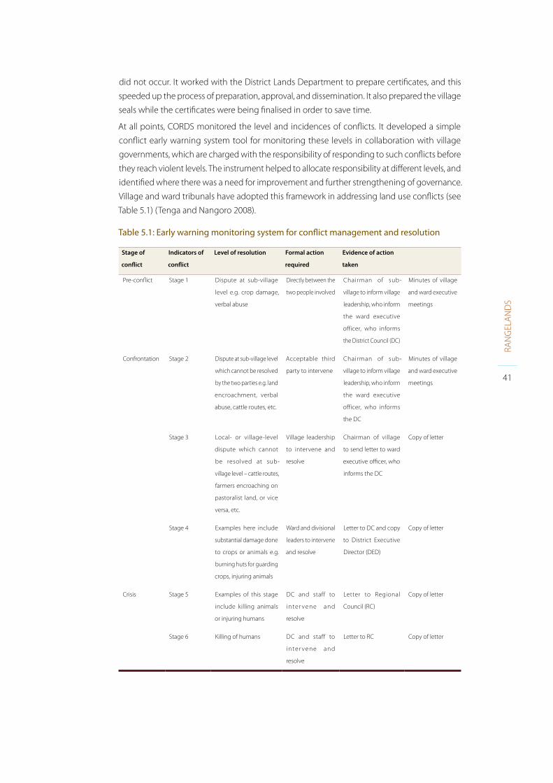
41
RAN
GEL
AN
DS
did not occur. It worked with the District Lands Department to prepare certificates, and this
speeded up the process of preparation, approval, and dissemination. It also prepared the village
seals while the certificates were being finalised in order to save time.
At all points, CORDS monitored the level and incidences of conflicts. It developed a simple
conflict early warning system tool for monitoring these levels in collaboration with village
governments, which are charged with the responsibility of responding to such conflicts before
they reach violent levels. The instrument helped to allocate responsibility at different levels, and
identified where there was a need for improvement and further strengthening of governance.
Village and ward tribunals have adopted this framework in addressing land use conflicts (see
Table 5.1) (Tenga and Nangoro 2008).
Table 5.1: Early warning monitoring system for conflict management and resolution
Stage of
conflict
Indicators of
conflict
Level of resolution Formal action
required
Evidence of action
taken
Pre-conflict Stage 1 Dispute at sub-village
level e.g. crop damage,
verbal abuse
Directly between the
two people involved
Chairman of sub-
village to inform village
leadership, who inform
the ward executive
officer, who informs
the District Council (DC)
Minutes of village
and ward executive
meetings
Confrontation Stage 2 Dispute at sub-village level
which cannot be resolved
by the two parties e.g. land
encroachment, verbal
abuse, cattle routes, etc.
Acceptable third
party to intervene
Chairman of sub-
village to inform village
leadership, who inform
the ward executive
officer, who informs
the DC
Minutes of village
and ward executive
meetings
Stage 3 Local- or village-level
dispute which cannot
be resolved at sub-
village level – cattle routes,
farmers encroaching on
pastoralist land, or vice
versa, etc.
Village leadership
to intervene and
resolve
Chairman of village
to send letter to ward
executive officer, who
informs the DC
Copy of letter
Stage 4 Examples here include
substantial damage done
to crops or animals e.g.
burning huts for guarding
crops, injuring animals
Ward and divisional
leaders to intervene
and resolve
Letter to DC and copy
to District Executive
Director (DED)
Copy of letter
Crisis Stage 5 Examples of this stage
include killing animals
or injuring humans
DC and staff to
inter vene and
resolve
Letter to Regional
Council (RC)
Copy of letter
Stage 6 Killing of humans DC and staff to
inter vene and
resolve
Letter to RC Copy of letter

42
RAN
GEL
AN
DS
FARM Africa has also been involved in facilitating the resolution of conflicts over village boundaries8.
As above, the VC should lead this process; FARM Africa managed to extend this to include
traditional leaders, extension leaders, and women. In order to build the capacity of those involved,
training was carried out on conflict resolution, followed by conflict mapping and resolution
guided by facilitators and chaired by ward councillors from the respective areas. The process
was finalised with the village boundary surveyed by the district PLUM team and beaconed.
UCRT (with partners – the community, government, Oxfam Ireland, Wellspring and Maliasili
Initiatives) has also achieved much by using an approach led by joint traditional leadership between
the Sonjo and Maasai in Loliondo and Sale divisions, where there have been longstanding
disputes over land and territory. This approach has opened up space for constructive discussion,
which has allowed boundary marking to be done with the assistance of the Ministry of Lands.
Traditional leaders have been supported to engage with the local district government so that
they have a stronger role in decision-making processes and better understand the village land
registration and planning processes.
8 Including Mwada village vs Kisngaji village; Ngoley vs Mwada; Vilima Vitatu vs Minjingu; and Bassodeshi vs Garawja.

43
RAN
GEL
AN
DS
Collecting background informationThe more quality information collected on local land use, natural resources, stakeholders, etc.
prior to the involvement of government, the more effective and efficient the process of VLUP is
likely to be. A major cost for VLUP is government time – if the information required is collected
and organised prior to visits by local government officers, then they will need to spend less
time on collecting this.
Pastoralists have been classifying and assessing the quality of landscapes for grazing resources
for centuries (see Box 6.1). This knowledge and the processes of information collection need
to be incorporated into land use planning processes.
6.1 Participatory rural appraisal
Participatory rural appraisal (PRA) methods assist common decisions in complex situations where
there are conflicting interests. PRA provides tools for a simultaneous consideration of socio-
economic and environmental development in order to achieve changes to both. PRA makes it
easier for poor, less communicative, less active, and less powerful people to participate and to
express their opinions and needs in meetings. Here, villagers take responsibility for explaining,
assessing, and evaluating issues such as their situation and resources. They can be helped by
Box 6.1: Pastoralists’ classification and assessment of grazing lands
Maasai herders classify seasonally grazed landscapes using socio-cultural folk systems, soils,
topography and vegetation, management knowledge, and seasons of grazing. Herders
characterise grazing lands as degradable (orpora) or non-degradable (orkojita) in response
to heavy grazing pressure, with reference to soils (ngulupo) and vegetation type. This
categorisation is used for regulating seasonal grazing across heterogeneous landscapes.
Impacts of livestock grazing across seasonal grazed landscapes are evaluated in terms
of herder perceptions and field data on plant species composition, richness, biomass,
and cover. According to herders, degradation occurs in these landscapes (such as selela)
when traditional grazing systems are altered by crop cultivation. The disappearance of key
forage species and an increase in species less desired by livestock are used as indicators of
degradation. The overall effect of land degradation is inferred from a decline in livestock
productivity. The evidence suggests that descriptions of landscape degradation in terms of
loss of grazing value for a particular livestock species might be more relevant than a general
statement about rangeland degradation associated with pastoral land use. According
to these findings, land use planners could incorporate herder knowledge with scientific
methods to test the impact of management and promote community participation in
rangeland monitoring.
Source: Oba and Kaitira 2006

44
RAN
GEL
AN
DS
a facilitator, so that all participants learn from one other and teach each other in an egalitarian
way. If it is managed well, people can be empowered during the VLUP process (Ylhaisi 2010a).
PRA is step 2 in the NLUPC guidelines, and thus should always be an integral part of village
land use planning. However, the quality of PRA that takes place varies widely, and often it can
be little more than a short discussion with community members.
Collection of information through PRA or rapid rural appraisal (RRA) has proved beneficial in
land use planning processes (for example, in coastal villages – see Daffa et al. 2003). Information
can be collected with a PLUM team. However, in order to save costs, a CSO or NGO can assist
communities to collect as much information as possible prior to a visit by the PLUM team.
PRA/RRA can include the following steps:
• Forming a PRA team;
• Establishing good working relations with the village community and introducing the
idea of PLUP/M to them;
• Forming a Village Land Use Management (VLUM) committee;
• Assisting villagers in analysing and evaluating their problems and opportunities and in
making rational decisions on allocating land for different uses;
• Assisting villagers in the preparation of a community action plan (CAP) for land use
management;
• Obtaining general knowledge and baseline data about the villagers and their environment.
Information on the following can be collected:
• Clarification of land use patterns;
• Types of land utilisation;
• Status of land tenure: how is land accessed? Who owns which land?;
• Security of land tenure: do villagers feel secure with their land rights? Are they aware
and confident about their land rights?;
• Natural and cultural resources with unique value;
• Quality of natural and cultural resources;
• Land and resource use conflicts. What type of conflicts exist and what are the drivers,
causes, and sparks?;
• Communal land ownership and utilisation;
• Seasonal land use changes;
• Type of crops grown, land productivity, land husbandry practices;
• Distribution of rangelands, dry/wet season grazing, watering places, minerals for
livestock, etc.;
• Size of farms;
• Type of housing;
• Housing density;
• Village infrastructure;
• Management of solid and liquid waste;
• Types of pollution;
• Land degradation, environmental degradation;
• Security issues.

45
RAN
GEL
AN
DS
The PRA team will gather information and data in four distinct categories:
• Spatial data;
• Time-related data
• Socio-economic data
• Technical data.
Tools that can be used include:
• Participatory resource mapping (see Section 7.0);
• Two-stage resource mapping where the participatory map is aligned and compared
to a topographic map (e.g. 1:25,000), and information is transposed from the hand-
drawn map to the topographic one. The resource sketch map is richer in people’s
perception; the second map adds precision in the location of information;
• Transect walks;
• Time lines and trend lines;
• Livelihood mapping to identify all basic items required to support life in the village
and the availability of these within and outside the community, e.g. firewood, water;
• Household surveys for e.g. technical information such as land use conflicts, land
tenure, land productivity, land husbandry, land degradation;
• Ranking of problems and opportunities, in preparation for producing a CAP;
• Community action plan (including development priorities, proposed actions and
requirements, duties and responsibilities, work schedules, and identification of areas
where the community needs external assistance).
Scenario planning and visioning (see Box 6.2) can also be useful tools for considering how
communities envisage or want their land and resources to be used in the future. For examples
of use and guidelines on these and other tools, see the comprehensive “Decision Support Tool”
developed by FAO, the African Wildlife Foundation (AWF), the International Livestock Research
Institute (ILRI), and the Government of Tanzania (FAO et al. 2008).
The information collected can be digitised and a GIS system can be used to improve the gathering,
analysis, and interpretation of data to produce village profiles (see next section). However, this
information should remain in a format that can be easily interpreted by all those involved.
Box 6.2: Scenario planning
Scenario planning has proved to be a useful way of engaging with stakeholders, sharing
understanding, exploring potential change, and defining a common vision to meet development
needs, as well as achieving environmental management and protection goals (Sayer 2009).
SOS Sahel International UK and IIED have supported governments in Kenya and Niger to
work with communities to define their needs, and have suggested alternative scenarios in
relation to social development, including mobility and education. The results have formed
the basis of land use and development and education policies and strategies in these
regions. The experiences showed that the process was particularly useful for planning in
a context of uncertainty and so highly suitable for rangeland communities. Guidelines to
this effect have been produced (SOS Sahel/IIED 2009; Cavanna and Abkula 2009).

46
RAN
GEL
AN
DS
The better the analysis of the data by rangeland users, the more meaningful the resource
plan is likely to be. CORDS, for example, in its VLUP work, assists communities to assess the
status of each resource against their use and requirements. Various resources are clustered
and assessed using a gridded geo-referenced system, which is updated on a regular basis
(resources permitting). This includes the drawing of sketch maps which are re-drawn by CORDS’
cartographer, incorporating information gathered from and verified by the villagers. The NGO
also carries out land valuation exercises based on identification of soil types, suitable areas for
pasture and other uses, soil conservation mechanisms, forest reserves, etc. The village profiles
pull together and systematise the following information:
CORDS and the communities used the above information as a basis for the zoning of lands
according to specific uses. Further mapping of resources was carried out (see Section “Participatory
mapping of rangeland resources”). The land was then zoned according to residential areas,
grazing areas, agricultural areas, wildlife areas, reserved areas, water sources, and stock routes.
Descriptions and sketch maps were produced for each zone. Signboards were placed indicating
the boundaries of each zone and an official map was produced using GPS. CORDS ensured
that villagers led these processes.
Visual representations can offer a better route to communication and understanding than
mere description – it is true that “a picture paints a thousand words”. Community maps can be
developed to illustrate the desired outcomes or a vision for the future (as used in Uganda:
Boedhihartono and Barrow 2008). 3D geographical visualisation tools (Petit et al. 2006) and
modelling packages such as STELLA, SIMULE, or VENSIM (purchasable via the Internet) can
also be used. An example from Indonesia describes the use of STELLA to explore different
future scenarios and their implications for forest cover and for local communities’ incomes
from oil palm investment and REDD (Indonesia: Sandker et al. 2010. Local communities’
understanding of such media should not be underestimated).
Such processes can be time-consuming, however, and it is necessary to balance the
constraints of deadlines and time pressures with the needs and paces of different stakeholders.
The agenda should not be an end in itself but a means to achieve a collectively defined
desired outcome.
Objectives: Economic growth; Basic needs; Development planning; Ecological balance
Information needs: Natural physical resources; Technological information; Socio-
economic and demographic data; Soil; Natural resource management; Special analysis of
socio-economic data; Geology; Water management; Population trends; Geomorphology;
Pasture management; Social profiles; Groundwater; Pastoralism; Cultural profiles; Land
cover; Agriculture; Economic profiles; Rainfall and climate; Water harvesting; Food security
profiles; Drainage; Housing construction; Environmental profiles; Watershed; Wildlife
management; Water resource mapping; Slope aspects and altitude; Health and sanitation;
Forestry profiles; Settlement patterns; Farming systems; Grazing patterns; Food systems;
Water sources; Forestry resources; Salt licks

47
RAN
GEL
AN
DS
Participatory mapping of rangeland resourcesParticipatory maps allow communities to express themselves spatially through drawing the
landscape, its natural resources, and their own use of these. Such maps can provide an alternative
to the languages, images, and written words of those who may hold more power in society. The
process itself is a valuable and empowering exercise: the knowledge sharing and discussions
that take place provide opportunities for learning and identifying problems and solutions. If
the process is well facilitated, a large number of community members can take part, including
men, women, young, old, rich, and poor.
Participatory mapping is a good starting point for discussing resource and land-based issues.
It enables communities to display and document resource distribution and identify important
features that they use. A map and documentation of such use may help to legitimise it in the
eyes of government. The map can be used in negotiation processes and the definition of
different land use zones and access agreements. It is a key piece of documentation in rangeland
management plans. It can also form a baseline for monitoring and evaluation (M&E), and
within adaptive management processes. Participatory mapping tends to be low-cost and is
not dependent on complicated technology; however, GIS can add value to participatory maps
through sorting and layering information, which can be useful for specific tasks or objectives.
7.1 Key stages and steps in participatory rangeland mapping
In rangeland resource mapping, practitioners are advised to undertake the process in three
distinct stages: preparation, facilitation, and documentation. Practitioners should follow a series
of steps within each of these stages before moving onto the next one. Taking a step-by-step
approach will ensure that the mapping process is effective and participatory, and the resulting
resource maps will become central to the rest of the VLUP process.
Key stages and steps for participatory rangeland resource mapping:
STAGE 1 – Preparation
• Step 1: Setting the mapping objectives
• Step 2: Establishing the facilitation team
• Step 3: Identifying the mapping participants
STAGE 2 – Facilitation
• Step 4: Producing a rangeland resource map
• Step 5: Adding more details to the map
• Step 6: Completing the mapping process
STAGE 3 – Documentation
• Step 7: Obtaining feedback from other stakeholders
• Step 8: Writing the mapping report
• Step 9: Taking the map and reporting back to the community.

48
RAN
GEL
AN
DS 7.2 Mapping of rangeland resources in neighbouring villages, Kiteto
Rangeland resource mapping was piloted in Kiteto District by the Sustainable Rangeland
Management Project (SRMP), with an implementing partnership between the MLFD, the Ministry
of Lands, district governments, ILC, IFAD, CARE, TNRF, NLUPC, and a number of CSOs. Over ten
days, two neighbouring village communities mapped out resources and mobility routes.
The reciprocal resource sharing arrangements that existed between the two villages were
highlighted by the maps: one village moved to the next for water, and the one with permanent
water moved to the other for grazing. Where women produced a map of their own, the depth
of their knowledge was well appreciated by male members of the community. New resources
such as an earth mound used for mobile network connection showed how pastoralists are
making the most of new communication opportunities. The participants who took part valued
the mapping process highly, and agreed that rangeland resource mapping should be included
as an initial step in the government’s VLUP. The SRMP is working with the government to this
end. For more information, see the report of the mapping (Flintan 2012) at: http:landportal.
info/topic/rangelands-tenure.
7.3 Mapping of livestock routes, Wami Sokoine Village, Mvomero District
In Morogoro Region livestock ranches have been established across the districts of Kilosa
(three), Mvomero (53), Kilombero (11), and Ulanga (four). Mvomero has the most ranches, of
which 51 are owned by pastoralists (Mashingo 2012). Many of these are found in Wami Sokoine
village. The natural resources found in the village are under pressure and fenced enclosures
are common. VLUP has not yet been carried out in the village.
Mapping of natural resources and other features including livestock routes was carried out
through a participatory process, based on the above methodology, by representatives of the
MLFD, Tanzania Livestock Research Institute, Sokoine University of Agriculture, local district
officials (including a PLUM team), and CARE Tanzania. Around 60 village members took part
in the exercise.
Box 7.1: Should mapping be done in mixed groups, or with men and women separated?
There is disagreement about whether it is better to ask men and women to make one map
together or whether it is better to have men and women make maps separately, and then
to combine them through joint discussion and agreement. A possible disadvantage of men
and women mapping together is that men may dominate the process and may not allow
women to fully contribute. This can result in women’s views, knowledge, and ideas being
missed. Also, women themselves may not feel comfortable contributing in the presence
of men (for social, cultural, or religious reasons). However, mapping in separate groups can
also have its disadvantages, not least in creating divisions that are unnecessary. It may also
produce less accurate and detailed information, and merging two maps is a difficult task.
Meanwhile the process of men and women mapping together could have produced a
dynamic and discursive means to agreement as to what should be included or not. It can
also give an opportunity for men and women to learn from each other – something that
might not occur on a daily basis under normal circumstances.

49
RAN
GEL
AN
DS
The mapping of corridors was followed by in-depth discussions amongst the community
on the current challenges of accessing adequate resources for livestock production and, in
particular, water.
The stock routes are not formalised and do not receive any legal protection, even though most
of the routes have been in use for centuries. VLUP has not yet been carried out in the village
and there are no immediate plans to do so.
Participatory rangeland resource mapping was considered to be a useful tool for VLUP

Ngabolo village mobility map example
Livestock routes,wet season
Livestock routes, dry season
Village boundaries
Settlement
Household
Farming area
Seasonal stream
Dam
Saltlick area
Hill
Road


52
RAN
GEL
AN
DS
Working through government process of VLUP is time-consuming and complex

53
RAN
GEL
AN
DS
Use of GIS and satellite imageryIn step 3 of VLUP under the NLUPC guidelines, it is anticipated that GPS/satellite images will be
used to identify land uses and resources. It is expected that a land use map is produced using
GIS, so that boundaries between different land uses are clearly seen.
Good data for such mapping in Tanzania is not easy to come by: most data-sets tend to be
out-of-date. Digital Chart of the World and FAO Africover are starting points. The Tanzania
National Roads Agency (under the Ministry of Infrastructure Development) has screen-digitised
regional roads. FAO and Tanzania Natural Resources Information Centre (TanRIC) have mapped
some infrastructure and surrounding areas such as power stations and dams, as well as land
use and cover. The Tanzania Electric Supply Company has also carried out mapping of these
features in some areas. Roads and rivers have been mapped by the Surveys and Mapping
Division of Tanzania.
See also for relief and drainage: CGIAR-CSI or Shuttle Radar Topographic Mission (SRTM); geology:
GISIC Naliendele; soils: Sotersaf; rainfall: Almanac Characterization Tool (ACT) database; protected
areas: World Database on Protected Areas (WDPA) or the protected areas themselves. ILRI has
also carried out mapping in some areas, including of ward boundaries.
Topographic maps – 1:50,000 from Series Y742, Edition 1-TSD (1965–1966), Landsat 5 TM, Landsat
7 ETM+, and Landsat 5 TM images (1994, 2001, 2008) – are also available. The Tanzania GIS User
Group (TZGISUG) supports users and enthusiasts of GIS.
Another key challenge is that data coverage is not complete and often data-sets do not entirely
match one other – for example, the FAO Africover and ILRI mapping of ward boundaries have
been found not to match (Ball and Gregory 2007).
8.1 Participatory GIS in mapping local context of conflicts
Participatory GIS (PGIS) combines participatory approaches to planning with the collection
of spatial information and communication management. By boosting local ”ownership”
of information collected, PGIS can reduce conflicts, as the community is involved in how
that information is used and to what ends. If handled appropriately, such information
can be used to develop a common vision, facilitate negotiation and agreement between
different parties, and realise positive solutions. In Duru Haitemba, Babati, Manyara Region,
participatory digital mapping was used, with the intention of empowering mapping
participants and communities through knowledge sharing and raising awareness during
and after the mapping exercise. The community mapping and PGIS proved to be useful
tools for examining conflicts and their spatial and temporal distribution. A masters student
carried out the work, in conjunction with the LAMP project (Mandara 2007). Data was
collected from:
• Primary and secondary data sources, including profile and village development
reports, village administrative records, etc.;
• Sketch maps used to map local knowledge of grazing resources and related conflicts;

54
RAN
GEL
AN
DS
• GPS point tracking during transect walks to record the location of grazing resources
and conflict areas. This was done in order to ground-truth information collected
during community mapping;
• Aster 2005 satellite images, which were used to obtain the land cover/use of the study
area so as to visualise conflicts from sketch maps in proper projection;
• ArcGIS 9.1 and ERDAS Imagine software 8.7 was used for analysis and visualisation of
conflicts and changes in grazing resources as well as image classification to obtain a
land cover and land use (LCLU) map of the study area.
The information collected provided a foundation for discussing in different forums and with
different focus groups the types of conflict and responses, and their causes and effects. Practices
for conflict resolution were also discussed. Information collected during the mapping of resources
was used as a starting point for digitising grazing areas (private and communal), cattle tracks,
crop residues, and livestock water points. Observation points were recorded during the transect
walk, showing the accuracy of the community’s map. It was shown that the sharing of resources
is becoming increasingly restricted, and that many grazing areas have been lost to other uses or
are protected as community forest. The sketch and digitised maps, and other documentation
resulting from the research, will prove to be useful inputs for VLUP.
8.2 Resolving boundary disputes
Boundary disputes were resolved in Kisanga with the assistance of a small research project by
students and staff of the Faculty of Geo-science Information Science and Earth Observation of
University of Twente, Netherlands (ITC) and University College of Lands and Architectural Studies
(UCLAS – now Ardhi University), in conjunction with CARE Tanzania (the Msitu Yetu project).
Causes of boundary disputes were unclear demarcation, tenure insecurity, and insufficient
dialogue between disputing groups. As a first step in understanding the situation, community
members were assisted to draw a sketch map of the area. In order for the researchers to find
their bearings, several landmarks were marked by GPS. Landsat TM satellite images with a
30-metre resolution served as a mapping background.
Showing the conflicting boundaries on a map made the problem areas spatially explicit and
helped to focus efforts of the villages involved to mitigate the problems. Though GIS itself
is by no means the solution to boundary disputes, the immediate visual output assisted in
discussions. Much of the quality and usefulness of the data recorded with a combination of
personal digital assistant (PDA) and GPS depended on the skills and knowledge of the operator,
and specific knowledge is required to prepare the right configuration in order for the use of
such tools to become straightforward.
The exercise also allowed some key good practice principles of PGIS to be verified:
• The need for accountability, expressed in terms of transparency and visibility of
decisions: mobile PGIS does this, as long as a representative group is involved in the
transect and boundary walks;
• Promotion of participation by the disadvantaged and less articulate, and usually by
women as a particular group: mobile GIS will support this, if some training is given
and the mapping activities are scheduled for an appropriate and convenient time;
55
RAN
GEL
AN
DS
• Support and respect for local knowledge and indigenous spatial knowledge: mobile
GIS makes explicit the use of local people’s knowledge of spatial boundaries, resource
conditions, indigenous zoning principles, etc.;
• Competence i.e. the capacity to acquire, understand, and use actual information that
has real meaning for local people, so making it more tangible.
8.3 Pastoral resource mapping
District actors in Longido, with support from TNRF and IIED, have combined community
perception maps, drawn on the ground using conventional participatory learning and action
(PLA) techniques with Google Earth9 to map pastoral resources and livelihood dynamics at
the landscape (rangeland) scale. By integrating maps produced by communities with Google
Earth, it has been possible to enable pastoral communities to articulate to local government
planners the extent and depth of their knowledge of their environment and the rationale
of their livelihood strategies in environments characterised by high resource variability and
unpredictability. The maps have helped to facilitate dialogue and better understanding between
local government authorities and local citizens, and identify plans to strengthen livelihood
resilience. More information is provided in Section 11.5.
8.4 OpenStreetMap
OpenStreetMap has updated its satellite imagery covering parts of Arusha and Serengeti. The
imagery is delivered by search engine Bing (Microsoft) and allows for the tracing of roads and
buildings in these areas. Microsoft has updated much of its imagery covering Tanzania in the
past year. For Arusha, the imagery covers the area east of a north-south line going from the
Nane Nane agricultural showground up towards the Philips area. Although the imagery is
rather greyish, it still serves as an excellent basis for tracing buildings and roads. This could be
a useful input to VLUP in these areas.
8.5 Mapping of resources in Gombe National Park
In the Gombe National Park and adjacent village lands the Jane Goodall Institute (JGI) has
been working with the Colorado Springs-based company Native Communities Development
Corporation (NCDC) to develop a full inventory of forest resources and human land uses in the
Greater Gombe ecosystem (GGE), as a basis for Conservation Action Planning (CAP) and Village
Land Use Planning (VLUP). NCDC’s Satellite Imaging and Mapping Division has developed an
integrated mapping system that maximizes the power of DigitalGlobe’s QuickBird sub-meter
satellite imagery. The system allows for the rapid identification, mapping, measurement, and
assessment of natural and man-made features across landscapes ranging from one to many
thousands of square miles (see Figure 8.1)10.
9 Google Earth is a 3D mapping program by Google that covers the entire globe using satellite images, allowing the user to navigate
planet Earth from multiple viewpoints (Google Maps). Google Maps offer views of both infrastructure (such as cities, streets, and
buildings) and geographical terrain (such as mountains and rivers).
10 This proprietary system employs object-oriented machine learning software in conjunction with NCDC-designed algorithms and
“target identification models” to achieve recognition of unique patterns or “features” that exist within the satellite imagery, including
integrated combinations of point, line, and polygon data. The system incorporates spatial context, reflective spectral data, textural
patterns, and enhanced colour attributes in the automated feature extraction process. It also examines potential patterns from two
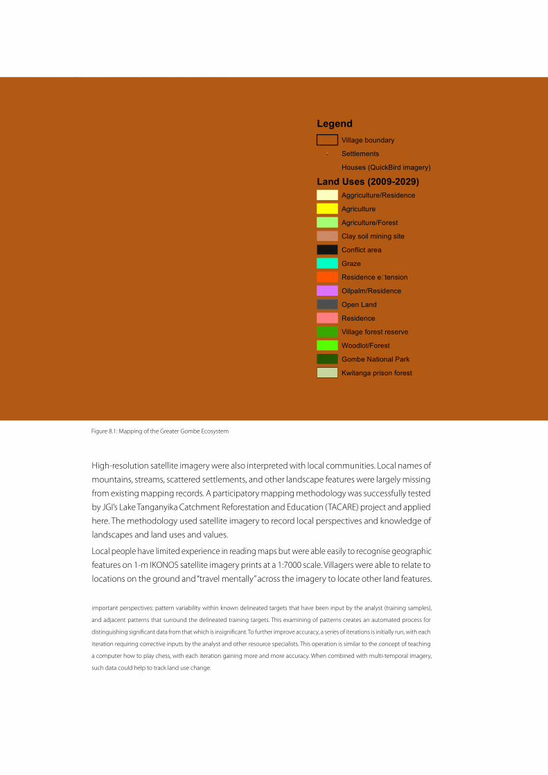
56
RAN
GEL
AN
DS
High-resolution satellite imagery were also interpreted with local communities. Local names of
mountains, streams, scattered settlements, and other landscape features were largely missing
from existing mapping records. A participatory mapping methodology was successfully tested
by JGI’s Lake Tanganyika Catchment Reforestation and Education (TACARE) project and applied
here. The methodology used satellite imagery to record local perspectives and knowledge of
landscapes and land uses and values.
Local people have limited experience in reading maps but were able easily to recognise geographic
features on 1-m IKONOS satellite imagery prints at a 1:7000 scale. Villagers were able to relate to
locations on the ground and “travel mentally” across the imagery to locate other land features.
important perspectives: pattern variability within known delineated targets that have been input by the analyst (training samples),
and adjacent patterns that surround the delineated training targets. This examining of patterns creates an automated process for
distinguishing significant data from that which is insignificant. To further improve accuracy, a series of iterations is initially run, with each
iteration requiring corrective inputs by the analyst and other resource specialists. This operation is similar to the concept of teaching
a computer how to play chess, with each iteration gaining more and more accuracy. When combined with multi-temporal imagery,
such data could help to track land use change.
Zashe
Mkigo
Kiziba
Bitale
Kinazi
Mtanga Kiganza
Bubango
Mwayaya
Kagunga
Muhinda
Mubanga
Matiazo
Mkabogo
KalinziBugamba
Kagongo
Kizenga
Mahembe
Kigalye
Chankele
Nyakimwe
Rusaba B
Rusaba A
Mkongoro
Nyamhoza
Mwamgongo
Nyarubanda
Mgaraganza
Kalalangabo
Changabwimba
Kwita
Gombe National
Park
La
ke
T
an
ga
ny
i ka
BURUNDI
E
Map developed by: Lilian Pintea0 4 82 km
KigaliKigali
BujumburaBujumbura
KampalaKampala Nairobi
Dar es SalaamTZTZ
CDCD
KEKE
ZMZM
MZMZ
UGUG
MWMW
SOSOEquatorEquator
40E
Land use mapping: Jovin Lwehaburaand Fadhili Abdallah
LegendVillage boundary
!. Settlements! Houses (QuickBird imagery)
Land Uses (2009-2029)Aggriculture/Residence
Agriculture
Agriculture/Forest
Clay soil mining site
Conflict area
Graze
Residence e�tension
Oilpalm/Residence
Open Land
Residence
Village forest reserve
Woodlot/Forest
Gombe National Park
Kwitanga prison forest
Village Land Use Plans in the Greater Gombe Ecosystem
Tanzania
Figure 8.1: Mapping of the Greater Gombe Ecosystem
Zashe
Mkigo
Kiziba
Bitale
Kinazi
Mtanga Kiganza
Bubango
Mwayaya
Kagunga
Muhinda
Mubanga
Matiazo
Mkabogo
KalinziBugamba
Kagongo
Kizenga
Mahembe
Kigalye
Chankele
Nyakimwe
Rusaba B
Rusaba A
Mkongoro
Nyamhoza
Mwamgongo
Nyarubanda
Mgaraganza
Kalalangabo
Changabwimba
Kwita
Gombe National
Park
La
ke
T
an
ga
ny
i ka
BURUNDI
E
Map developed by: Lilian Pintea0 4 82 km
KigaliKigali
BujumburaBujumbura
KampalaKampala Nairobi
Dar es SalaamTZTZ
CDCD
KEKE
ZMZM
MZMZ
UGUG
MWMW
SOSOEquatorEquator
40E
Land use mapping: Jovin Lwehaburaand Fadhili Abdallah
LegendVillage boundary
!. Settlements! Houses (QuickBird imagery)
Land Uses (2009-2029)Aggriculture/Residence
Agriculture
Agriculture/Forest
Clay soil mining site
Conflict area
Graze
Residence e�tension
Oilpalm/Residence
Open Land
Residence
Village forest reserve
Woodlot/Forest
Gombe National Park
Kwitanga prison forest
Village Land Use Plans in the Greater Gombe Ecosystem
Tanzania

57
RAN
GEL
AN
DS
They were able to map village boundary markers such as trees, stones, small streams, forest
patches, paths, and bridges; fields of oil palm, banana, and cassava; and places of worship such
as churches, mosques, and traditional belief sites.
For the first time, baseline geospatial data developed by combining both geospatial technologies
and local knowledge, was made available for rural communities, NGOs, and government
institutions in the Kigoma region. Building geospatial capacity in Tanzania was an important
cross-cutting theme of the Greater Gombe Ecosystem project (Pintea 2005) (see Figure 8.1).
This baseline data informed a Conservation Action Plan that was developed to identify and
prioritise conservation strategies in the Greater Gombe Ecosystem. GIS was used to overlay
deforestation layers, historic distribution of chimpanzees and habitats, slope, footpaths, roads,
streams, watersheds, density of human structures, and 60-centimeter QuickBird imagery to
prioritise a core conservation area that, if protected, would substantially increase the viability
of chimpanzees inside and outside the park and stabilise the watersheds for water quality, flash
flood and erosion control, and support community livelihoods.
A community action plan was produced by the community, and informed the village land
use planning process. Participatory village land-use plans were prepared by the communities
themselves, according to Tanzanian policy and with full involvement of government and
community stakeholders. The planning process followed seven steps and required villagers
to settle any existing land disagreements and agree on how land resources located within the
villages should be used to meet specific human livelihood needs and environmental objectives.
JGI facilitated the process and provided technical support, including maps and geospatial tools
to record and manage spatial data.
At the end of the project in 2009, 13 villages within GGE completed their participatory village
land-use plans, which were ratified by the Tanzanian government. Local communities voluntarily
assigned 9,690 hectares, or 26 percent, of their village lands to Village Forest Reserves. As a result
of the linkage between CAP and VLUP processes and geospatial technologies, these reserves
are interconnected across village boundaries to minimise fragmentation and cover 68 percent
of the priority core conservation area identified by the GGE Conservation Action Plan (Pintea
2011; http://www.esri.com/news/arcnews/summer11articles/from-maps-to-geodesign.html).
A follow-on initiative building on previous work by JGI and partners, the Gombe Masito Ugalla
Project, funded by the U.S Agency for International Development (USAID), completed VLUP in 36
villages between 2005 and 2011, which can be considered a reasonable achievement given the
challenges of the VLUP process. With renewed financial support from USAID, JGI and partners have
been engaged in facilitating the establishment of community-based organisations, developing
by-laws and building local capacity to implement these VLUPs and restore and manage newly
established Village Forest Reserves. Village governments identified village Forest Monitors that
have been trained at Pasiansi Wildife Training Institute in Mwanza. With support from JGI, Forest
Monitors have been equipped and trained to use Android smartphones and tablets and Open
Data Kit software to collect field data and report their observations on forest and wildlife threats.
A database of very high resolution DigitalGlobe imagery collected every 3-4 years will provide
detailed information on village land-cover/land-use change, such as re-growth in Village Forest
Reserves, monitor new threats, and evaluate and inform implementation of land use plans.

58
RAN
GEL
AN
DS
8.6 Mapping land suitability for conservation and development
The Land Use Planning Act (2007) (Sections 27–28) guides practitioners on conducting land
suitability assessments prior to VLUP being carried out. The assessments should provide information
in order to consider and analyse different land uses and their promotion or regulation within
the village land use plan.
This approach was used in south-east Tanzania in Nachingwea and Lindi districts, where the
Mpingo Conservation Project carried out the mapping of land suitability and its use. The area is
targeted for the resettlement of pastoralists from more northern areas. Mapping was carried out
using different data-sets, including information from FAO Africover and ILRI. This was done in
consultation with local communities and government, though such consultations seem to have
been shallow. The land use suitability mapping highlighted those areas that were more suitable
for receiving incoming pastoralists and those that were not so suitable (Ball and Gregory 2007).
8.7 Modelling land use change on the Maasai Steppe
On the Maasai Steppe, the ILRI formulated and tested models that incorporate spatial correlates of
agricultural expansion in order to predict local- and landscape-scale patterns of land use change
and their implications. Spatial data-sets were derived from remotely sensed imagery (dating from
2000), radio-collared animals, and GIS layers (obtained from Tangire National Park, the Surveys
and Mapping Division of Tanzania, the Shuttle Radar Topographic Mission, and the ACT database).
Using a model of multiple logistic regression, the relationship between agricultural land use
and its spatial correlates was evaluated based on biophysical predictors of land use change,
including rainfall, slope, etc. The team then examined the implications of the changes in
agricultural land use for the range and migratory corridors of key migratory wildlife species,
within the context of LUP and wildlife conservation. Their results showed that biophysical
variables provided the primary conditions for land cover conversions to agriculture. There
was a strong overlap between land suitable for agriculture, wildlife migratory corridors, and
wet season dispersal areas. The rapid conversion of rangelands to agriculture presents a major
threat to wildlife conservation and disrupts the ecosystem’s viability in supporting both its rich
biodiversity and agro-pastoral livelihoods.
Such information can provide valuable input into the development of village land use plans.
When communities have accurate information on the pluses and minuses of farming, livestock
keeping, wildlife, or other livelihood strategies, they can best zone their land for different activities.
The process of modelling presented here demonstrates a potentially useful tool for policy-
makers, allowing for estimation and visualisation of the land use implications in conservation
planning, LUP, and policy decisions (Msoffe et al. 2011; Kshatriya et al. 2011).
See also the use of satellite imagery and mapping carried out in coastal areas of Tanzania – Box 11.1.

59
RAN
GEL
AN
DS
Promoting the participation of womenIn Kiteto District, CORDS is working with ActionAid to secure village land use certificates and
plans in 21 villages. Currently the partnership is focusing in particular on empowering women to
enable them to gain secure access to land. The partnership’s activities entail organising women
and making them conscious of their land rights, as well as seeking to establish the necessary
institutional framework for their claims to be recognised. This includes facilitating demarcation
and the certification of village land, developing VLUPs and formulating by-laws, and establishing
village land registries. It also involves activities around accountability, such as increasing women’s
participation and reducing corruption in VCs and village adjudication committees.
This work builds on the long-term commitment of CORDS to improving women’s lives through
its Gender and Women Development programme, which was developed in the late 2000s.
Through training, women have learned about equal access, ownership, and control over land,
as well as the land laws and provisions that are supposed to protect communities from land-
grabbers such as foreign investors and local farmers. Their reaction to their new knowledge was:
“Why have our men, despite knowing all these things, they done nothing to secure our land and our communities?”
Their anger towards the men, and in particular local government authorities, was due to the
fact that on several occasions the latter had granted outsiders land without sticking to national
laws and regulations.
Following the training, a workshop was organised in Dar es Salaam, where hundreds of women
from all over the country gathered, including a group from Kiteto. For the occasion the Kiteto
women prepared a song about their men letting them down.
During the workshop, presentations were given, experiences shared, and advice exchanged on
land rights and how to secure them for women. At the end of the workshop a group of women
from northern Tanzania (including the group from Kiteto) marched to the State House to meet the
country’s President to express their anger that 200 houses belonging to women had been burnt
down – allegedly to make way for an Arab investor who wanted to establish a tourist enclave.
The march in Dar es Salaam assured the women that they had both the power and the right to
question the current situation in Tanzania, and to influence decisions made about their livelihoods.
The women’s protest in Dar es Salaam did not go unnoticed by the public or by politicians, or
for that matter by other women (ActionAid 2010).
9.2 Providing space for women to discuss and formulate plans
Women can benefit from opportunities to discuss issues themselves prior to an open public
meeting. This was the case in Gedamar village in Babati District. When the district administrators
planned a meeting on land use planning and management, they proposed that women should

60
RAN
GEL
AN
DS
organise themselves in a separate meeting before the public meeting. In so doing, the women
had the possibility to discuss these matters amongst themselves and to present a common
proposal to the Village Assembly. The women wanted to reserve use of part of a natural forest
near their homesteads, reducing the walking distance required to collect firewood and other
forest products. The women knew that the men had already made plans for using a forest
area far away. After the women defended their proposal in public, the VA approved it – for the
benefit of both men and women (LAMP/Sida 2008).
The training of villagers, including women, as village legal workers (VLWs) (see section 4.2) has
also had highly positive results in increasing awareness and influencing land-related decisions to
be more gender-equitable. This includes the provision of land to women, and the overturning
of male-biased inheritance practices. The women who have been trained have also benefited
themselves, increasing their status, while many have become leaders (LAMP/Sida 2008). When
the VLWs began their work in Magadini, it was feared that few women would participate due
to demands at home or cultural pressures. However, in fact, more women than men took part
in the training sessions. Men, the VLWs said, were more difficult to inform, since they thought
they already knew all the land allocation procedures. Women were more eager to learn (ibid.).
9.3 Supporting women’s empowerment
MWEDO uses an integrated approach to build women’s empowerment including education,
economic support, civic education, capacity-building, and improving security of access to
resources including land. For example, the NGO works with Maasai women to build literacy skills
and basic numeracy (through Regenerated Freirean Literacy through Empowering Community
Techniques, or REFLECT). It also aims to give women the opportunity to gain business knowledge,
so as to promote their ability to earn independent incomes. Specific income-generating activities
have been conducted with women’s groups in Kiteto and Longido districts.
This has been promoted through the establishment of a Pastoralist Women Forum, in which
22 Maasai women role models were identified and underwent leadership training. The forum
will participate at village level in necessary dialogues and discussions. Other women have also
attended leadership training to better equip themselves in their current positions.
MWEDO has encouraged women to form networks to increase their “group power” and take up
leadership positions. Their participation in savings and credit schemes has also improved their
status, confidence, and ability to influence decisions (including in planning processes). MWEDO
has encouraged women to demand land access and delivery through customary systems
and practices (such as seasonal use of land). Grassroots Women’s Land Academies have been
established to strengthen women’s networks in land and inheritance rights, while community
paralegals have been trained to support their protection. Village sensitisation meetings have
been carried out on issues such as land ownership. Dialogue with VCs and traditional leaders
is coordinated to enable and support women to own part of their families’ land. MWEDO has
also worked with surveyors to deliver simple tools for carrying out land surveys at the village
level. As well as building the capacity of local women, the organisation has lobbied government,
advocating for greater support for women to access land.
MWEDO states that these activities have provided more opportunities for women to be involved
in LUP processes. There is increased local government support in adapting and making use

61
RAN
GEL
AN
DS
of land tools to improve women’s access to land and property. There has been increased
representation of rural women in policy formulation processes and in decision-making processes
at different levels. MWEDO also suggests that men and women have made use of land use
plans to demarcate their lands. As a result, more women own land through both customary
and legal land ownership. Around Namanga, for example, of 300 individual plots registered,
200 have been given to women.
9.4 Awareness-raising, paralegals, and exposure
Dodoma Environmental Network (DONET), funded by Norwegian People’s Aid (NPA) and active
around the Dodoma area11, has supported awareness-raising amongst women, including the
training of female (and male) paralegals. Other activities have included the preparation and
dissemination of simplified posters, leaflets, and booklets on land policy, laws, and guidelines
in local languages. Local women (and men) have been taken on exposure visits to the national
Parliamentary Exhibition Day and Farmer’s Day to learn about successes in building the livelihoods
of women. DONET has also implemented a supporting project called Good Governance in
Village Land Administration Structures, which is funded by the Prime Minister’s Office, Facility
of Ethics and Accountability.
DONET reports that the improvement of land policy awareness and popularisation amongst
women has resulted in women openly demanding their rights, their increased involvement in
decision-making processes, and increased access to and control of land from 5% to 25% in three
villages. Some women have taken on leadership positions. For example, one woman’s husband
registered himself as sole owner of their land. She argued with him that she also had rights and,
after much discussion, her husband relented and allowed her to register six acres of the 40-acre
holding in her own name. This success influenced other women to do the same (DONET 2011).
9.5 Governance challenges and women’s collective action
PWC and UCRT have been working with pastoralist communities in northern Tanzania, particularly
in Simanjiro District, Loliondo Division, and Longido District, for more than 15 years. They
have piloted community LUP processes in a range of communities in these areas, and their
experiences highlight the external political challenges faced by communities in securing rights
over lands and resources, and the ways in which land use plans may be ignored as a result of
external interests. This has been particularly evident in long-running conflicts over land rights
in Loliondo, where government and investor interests in wildlife and tourism have conflicted
with local land rights interests since the early 1990s (TNRF and Maliasili Initiatives 2011).
Governance challenges to enforcing and adhering to participatory land use plans also exist
at the local scale. If local village or ward officials do not ensure that decisions around land
and resources are made in a transparent manner, then land use plans may simply be ignored.
Thus PWC and UCRT have learned that, for land use plans to be influential in assuring local
communities greater rights, livelihood security, and economic opportunities, governance is
critical at multiple levels.
As a result, and in line with their broader objectives around social justice and community-level
empowerment of women, PWC and UCRT have worked together to increase the ability of
11 Note that this work is in an agro-pastoral/agricultural area.

62
RAN
GEL
AN
DS
women to mobilise and organise in order to influence both external and internal challenges in
local governance. UCRT, with support from the Ford Foundation and in collaboration with TNRF,
began the process of establishing Women’s Leadership Forums in Longido District, which has
since been scaled up to several additional districts. These bodies provide a structure for women
from village to district level to collectively organise, develop common agendas around land and
other resource uses and development challenges, and interact with other groups within society,
including traditional leadership and elected officials. The forums strengthen women’s organisation
and solidarity at the community level, better positioning them to demand accountability from
village governance bodies and to ensure that women participate in collective local decisions.
Women’s groups in Loliondo have played a crucial role in community efforts to resist external
pressures on land since crises broke out in 2009 around community evictions from critical
community grazing areas on village lands. Women have demonstrated a strong capacity to
organise and take forward community concerns and interests in the face of powerful external
commercial and political pressures. The capacity of women to organise themselves to face
up to external and internal governance challenges is ultimately crucial to the processes of
transparent and accountable decision-making that collective governance of land depends on.
For more information, see Maliasili Initiatives (2012).
Assisting women to play a stronger role in decision-making processes is an important part of good VLUP

63
RAN
GEL
AN
DS
Protecting customary lands within villagesThe Land Act and the VLA provide an avenue for the proof and recording of customary titles
by putting in place a process for the formalisation of pastoral title to areas such as grazing
land. Once village land has been registered and a village certificate has been provided, VCs
can allocate CCROs to individuals or groups. The Grazing Land and Animal Feed Resources Act
suggests that a pastoralist association is the most suitable pastoral grouping to which a CCRO
can be provided. However, similar associations have not been very successful in the past (e.g.
under the Range Development Strategy).
An applicant or group of applicants who seek to apply for a CCRO must apply to the VC, which
in turn must support the Village Adjudication Committee to carry out an adjudication of the
boundaries of the parcels of land in issue. The results are provided to the VC12. Once the VC is
satisfied that the land in question is free from objections, it submits the application to the VA
for approval. Once the approval is obtained, the Village executive officer (VEO) prepares a Letter
of Offer by filling out Form No. 19, and the applicant is supposed to signify his acceptance with
his signature (using Form No. 20 as per the VLA regulation of 2002). The VEO prepares three
copies of the CCRO, which should be signed by the land owner(s), the chairperson of the VC,
and the VEO, and sealed with the village seal. The VEO then sends three copies of the CCRO to
the registered district land officer for cross-checking, registration, and sealing. The district land
officer retains one copy, and two copies are sent to the VEO, who then registers the CCRO in
the Village Land Register and retains one copy (to be stored in the registry), while the other
copy is delivered to the owner.
The owner of village land holds the CCRO (usually) in perpetuity and subject to conditions
contained in the CCRO. As described above, the process of obtaining the CCRO is long and
involved. It requires technical know-how and the existence of infrastructural facilities that enable
the process of documentation, surveying, mapping, and registration at both the village and
district levels. These facilities are largely absent in most villages in Tanzania. According to officials
of the VLA section of the Ministry of Lands, the financial resources and technical know-how
required are beyond the means of the average village. However national programmes have
been started in the predominantly farming areas of Mbozi, Iringa, and Handeni districts (see
Sundet 2008), and the model there appears to have had some success. For the predominantly
pastoralist districts, NGOs/CSOs such as CORDS, UCRT, FARM Africa, Concern, etc. are doing
pioneering work in several rangeland areas working with pastoralists and hunter-gatherers
(Tenga and Nangaro 2008).
12 The Land Acts do not, however, provide for a method of codifying pre-existing customary law. The VLA does not even touch
existing customary tenures under what are known as deemed rights of occupancy, i.e. customary property rights that have neither
been granted by the government or by a VC but have been in existence from time immemorial. The possibility therefore of the
continuation of informal tenures still looms large (Tenga and Nagaro 2008).

64
RAN
GEL
AN
DS
It is suggested that the first and perhaps the greatest challenge is how to identify the entity
entitled to act as custodian of the commons (the group). The next challenge is then to define
the bundle of rights that may be registered with the title (Tenga et al. 2008). How is the collective
title within the bundle of entitlements to be defined in law? And once this has been done, who
is to be the legal custodian of that entitlement? Is it the representatives of the pastoralists, and
at what levels – starting from the family, the clan, the age group, or the neighbourhood? This
step, challenging as it may appear, is the ultimate legal tool that would enable pastoralists to
define their proprietary paradigm and defend it within the law. It is both a challenge and a
potential trap, in the sense that if pastoralists once failed in their quest, their lands would then
be open to access through legal means and a basis for lawful appropriation by non-pastoralists
would have been established (Tenga and Nangaro 2008).
Though it can prove highly difficult for pastoralists or hunter-gatherers to prove customary
title to their lands, with the help of external actors they have been able to overcome the
cumbersome titling procedures that exist.
Map of land use zones in Mongo wa Mono village, Yaeda

65
RAN
GEL
AN
DS
10.1 Registering customary title of hunter-gatherers
UCRT started working with the Hadza community in the Yaeda valley to secure land rights and their
traditional economic land use. From 2000 to 2006, UCRT assisted the community to undertake
a cultural mapping exercise aimed at: 1) enabling elders to teach the youth about the strong
connection between land and the Hadza culture; 2) showing government and official authorities
that the relationship of the Hadza with their lands is ancient and that this needs to be recognised.
UCRT also undertook VLUP and the development of by-laws with the Hadza in order to secure
their land area and natural resource uses. This included the reserving of a zone that can only be
used for hunter-gathering and in which livestock and agriculture are prohibited. The planning
has been carried out in the area where the Hadza’s presence is strongest, Mongo wa ono. In
October 2011 the Hadza’s natural resource use was given extra protection through the provision
of an official and legally binding CCRO – the first in Tanzania issued to protect the collective
rights of Hadza as a group.
UCRT facilitated PVLUP as per the government guidelines. However, it carried out a more
protracted consultation process, including a series of formal and informal meetings at sub-village
level, prior to the PVLUP process. The draft plan was presented to the whole community, and
was then discussed and modified through various meetings. The longer consultation process
took time and resources but, as a result, the plan is more likely to be upheld and supported.
In order to increase the security of access to land for the Hadza, UCRT then looked at what else
could be done, having identified the CCRO as the mechanism for this. However, the Hadza local
governance institutions that would have existed in the past were no longer fully functioning. This
was a barrier to the community obtaining a CCRO and they had to be bypassed. The Hadza were
reluctant to pass authority over their lands to only a few individuals through the CCRO – rather, they
wanted to have many people involved to prevent corruption. UCRT extensively lobbied the district
and commissioner’s office to provide the Hadza with a communal CCRO. UCRT used the land use
plan and evidence of the length of time the community had occupied the land to persuade the
government to support this – which, eventually, it did. After the CCRO was obtained, the Hadza
were given additional training on their rights and responsibilities according to the certificate.
10.2 Protecting grazing areas within village boundaries
Village land should be zoned by priority use; however, this does not mean that it has to be the
only use and integrated land use systems can still be supported. If an area is designated for
agriculture or forestry or tourism, livestock can still be grazed there at certain times of the year.
Again, village by-laws can formalise this arrangement if felt necessary.
Grazing areas can be provided with additional protection from the implementation of the
Grazing Land and Animal Feed Resources Act (2010) (Art 16 (1)(2) and 17(1)(2)). This facilitates
the establishment of a pastoral association between pastoralists in a village (or between two or
more villages with a contingent grazing area) and the registering of an area under their control
for grazing. This should be registered with a) the relevant district and b) the MLFD. A certificate
of right of occupancy (CRO) for the grazing area can then be obtained that is collectively used
to give the association supreme access and management of it. However, the implementation
of the Act is still in its early stages and, to date, no CROs for grazing land have been issued.

The Hadza were assisted to protect their lands with a certificate of customary right of occupancy

67
RAN
GEL
AN
DS
Planning and implementing across villagesPlanning in drylands needs to take place through a participatory, integrated approach that
incorporates issues of scale and the interconnectedness of dryland ecological and social systems
if the resiliency of both the environment and communities (land users) is to be maintained
and built up (Flintan et al. 2013). However, integrated rural development and integrated area
development have a reputation for running into difficulties – largely because they are complex
strategies. It is difficult to overcome these problems of complexity and find a practical framework
to better integrate environmental, socio-economic, and policy issues at a regional scale. In
a political environment that supports small administrative units and the decentralisation of
power and resources to them and communities, planning at scale is particularly challenging,
as it will cut across the boundaries of these units and demand collaboration between different
authorities. In addition, integrated planning must be compatible with the demands of a growing
diversity of government institutions, funding bodies, NGOs, and user groups, and must avoid
bias in monitoring, planning, and management.
As discussed in section 1, lands held by individual villages are generally not sufficient to sustain
pastoral production, and rangeland users face trade-offs in securing resources and maintaining
a productive, extensive rangeland livelihood system. Wider reciprocal relationships at the scale
of many villages or even districts remain central to pastoralist land uses. Thus strategies are
required to incorporate these wider concerns. A number of facilities and mechanisms exist
within Tanzania’s policy and legislation, and their implementation can support planning and
implementation of land use and management at a larger scale than the village and is more
appropriate for rangeland production systems such as pastoralism. Some NGOs are building
on these opportunities or experimenting with them to identify appropriate solutions.
11.1 Joint village land use plans
In the Land Use Planning Act of 2007, there is provision for the development of joint LUPs for
resource management of grazing land, forestry, etc. Section 33 (1) (b) states: “Where resources
are shared between villages joint land use and management plans should be developed.”
Village land use plans can be developed between two or more villages. Joint village land use
plans are particularly relevant where there is significant sharing of resources across the villages.
These must be developed in addition to single VLUPs – so the cost of producing a second, joint
one can be prohibitive. However, because the joint VLUPs facilitate and formalise inter-village
resource management, the chances of conflict are reduced – and this is likely to save costs in
the long term. In addition if all individual plans for the villages who share resources are carried
out at the same time and feed into the joint village land use plan this can significantly save costs.
CORDs is aiming to support the development of joint LUPs in order to integrate Maa pastoralist
indigenous models of NRM into the formal processes of land use planning.

68
RAN
GEL
AN
DS
11.2 Inter-village “resource management sector” planning
A second mechanism for clarifying and protecting shared resources is the inter-village ”resource
management sector plan”. In order to provide for sharing of resources between several villages and
movement across boundaries, villages are required to produce a “village resource management
sector plan” as well as their own VLUPs (as stipulated in the 2007 Land Use Planning Act, the
Village Land Act 1999, Section 11, and its Regulation 2002, No. 26-35). As the Land Use Planning
Act states (Art. 33 (1a)):
“Every village land use planning authority shall … in respect of resources shared with other villages, prepare jointly with other villages’ planning authorities a village resource management sector plan and submit such plan to the district planning authority for rationalisation and incorporation into the district land use framework plan …and where the villages belong to different districts, shall consider them jointly.”
The resource management sector plan deals with and facilitates the sharing of resources, and
should be incorporated into district land use plans (discussed further below). The agreement
and management of sector plans and by-laws can provide a formal framework for sharing
resources, with details of which neighbours can use which resources, how, and when.
With several villages planning together and entering into an agreement to share specific areas,
the area available to pastoralists within those villages is increased, and by-laws can be phrased
in such a way as to provide flexibility of use.
To date no village resource management sector plan has been produced, though cross-village
harmonisation of NRM has been supported. For example, UCRT often works with multiple villages
to harmonise resource management plans and rules over larger areas. In a number of cases
UCRT has started working with an individual village on a LUP, but when it became apparent
that resource use extended over larger areas (e.g. conflicts between livestock grazing and
farming, charcoal extraction, or pastoralist movements), the work was extended to neighbouring
villages in order to scale up the scope of the planning efforts and address resource sharing
issues (UCRT 2010).
11.3 Development of district land use plans
In order to secure pastoralist resources, it is important to demarcate broad areas that should
be designated as pastoral land to be used exclusively for grazing: the production of district
land use plans (DLUPs) can be a starting point for this. This process can begin by carrying out
a survey of districts with significant pastoralist populations to establish the status of land use
patterns, and then developing a strategy for assisting such districts to develop DLUPs with
specific areas demarcated for pastoralists. Village resource management sector plans should
contribute to these (Section 11.2).
Such a process has already started in Kilosa District, and other districts could be facilitated
to do the same. Another example (albeit in non-pastoral areas) of planning at scale that has
contributed to DLUPs is described in Box 11.1. These plans can be used for informing, identifying,
and issuing individual or collective CCROs, including for grazing areas. However, the process
is slow, and by the end of 2010 only 13 districts out of 127 had finished their DLUP (Yhlaisi
69
RAN
GEL
AN
DS
2010b). In Longido district, IIED and TNRF, together with district working groups through climate
change-focused projects, are assisting districts in the development of DLUPs in order to raise
awareness of and facilitate planning at scale.
Even without DLUPs, it is important that facilitating partners work with district government
staff to ensure that VLUPs are part and parcel of district planning processes. This is important
since district-level decisions can either support or disable local plans and enforcement efforts
(UCRT 2010).
Box 11.1: Planning at scale in coastal areas of Tanzania
The Marine and Coastal Environment Management Project (MACEMP) was a World Bank-
funded project launched in December 2005. It was implemented by the NLUPC in three pilot
districts of Kilwa, Rufiji, and Mafia districts for the first two years and was later rolled out to
the remaining coastal districts for the rest of the project’s life (2006–2012). The purpose was
to improve the management of coastal and marine resources and contribute to economic
growth and poverty reduction among coastal communities. The development of resource
assessment, mapping activity, and VLUPs was an important part of this.
Awareness-raising was conducted and completed in all 16 coastal districts, with a total of
3,200 representatives from coastal villages and 640 district officials trained and sensitised on
LUP issues. A few members of the PLUM teams were selected for training in GIS applications
and for the establishment and management of a district-level GIS database.
A reconnaissance land resource survey at a scale of 1:250,000 was conducted and completed
in several of the coastal districts. The activity covered the entire administrative area of the
district and included physical resources, hydrological resources, vegetation, wildlife, unique
features, and current land use. The information generated was provided in GIS overlays at
the reconnaissance level (map scale 1:250,000) for the district level and at detailed level
(map scale 1: 10,000) in a few villages. Information was collected and compiled in the
form of reports and maps, complemented by PRA and field observation through transect
walks, with intensive use of GPS. The land resource data was analysed in a GIS environment
using ArcView 3.2 and Arc GIS 9.2 software programs. The analysis involved digitisation,
reclassification, overlays, distance analysis, etc. The socio-economic data was analysed
using IBM’s SPSS statistical software.
The outcome of this survey and analysis was the availability in digital format of valuable
detailed information on geology, land forms, soil types, hydrology, vegetation, land use,
and social/economic facilities and infrastructure (administrative boundaries, road network,
education and health facilities, residential areas, fish landing sites, historical and cultural
sites, population distribution and density, and categories of public lands) presented in maps.
Based on the analysed biophysical and socio-economic data, a land evaluation was carried
out using the FAO framework guidelines to obtain a suitability assessment and classification
of various land use enterprises utilising coastal and marine resources. District Land Use
Framework Plans were prepared for all coastal district councils, based on their administrative
boundaries. Specifically, these plans indicated the broad zoning of district land for the

70
RAN
GEL
AN
DS
development of both smallholder and large-scale commercial investments in farming,
livestock development, fisheries, tourism, conservation projects, settlement patterns
and distribution, mining, and infrastructure development, among others. The framework
plans were presented to the authorities of each district and to stakeholders for approval
and adoption.
Detailed resource assessment and suitability mapping were carried out at village level to
provide information on land resources needed for VLUP and NRM. The exercise required
detailed maps at a scale of 1:10,000, which were developed with the use of high-resolution
satellite images processed into level 3 GIS maps from Landsat, SPOT Image, or ASAT. The
first batch of satellite images covered the coastal strip of Kilwa, Rufiji, and Mafia districts.
These were obtained from ASAT imagery with a resolution of 15 metres processed at level
1. The images’ resolution and their level of processing called for intensive ground-truthing
and use of high-capacity computers to handle the bulky data produced.
Shortage of funds for ground-truthing and lack of high-capacity computers delayed the
preparation of detailed resource maps and suitability maps for project villages in these
three districts. Only 45 villages out of 84 have been covered. Outputs for each village
have been seven GIS land resource maps covering the 45 villages (geology, land forms,
hydrology, soil types, land cover, present land use) and logistic maps at a scale of 1:10,000.
Where maps have been produced, suitability assessments and classification of various land
use enterprises utilising coastal and marine resources have been determined. The data
collected provided the village communities, planners, and decision-makers with scientific
evidence to inform decisions on the allocation and management of land resources for
various uses at village level.
The outputs for each village also included an assessment report accompanied by no less
than ten crop suitability maps and six GIS suitability maps for non-agricultural economic
enterprises (aquaculture, livestock-keeping, solar salt-making, plantation forestry, beekeeping,
and eco-tourism), produced at a scale of 1:10,000 and printed on A1-size paper. The VLUP
process included the establishment and training of village institutions for village land use
planning and management, including village land use management committees (VLUMs)
and village land councils (VLACs).
Following the realisation that VLUP by local government authorities was proceeding very
slowly, it was decided that the NLUPC should intervene to speed up the process. During the
period 2011/2012 the NLUPC, in collaboration with LGAs, developed 36 VLUPs. A number
of LGAs prepared village plans on their own. The NLUPC was hoping to collect these plans
from LGAs for the purpose of standardisation and submission to the Minister of Lands for
gazettement, but failed to do this due to a lack of funds. The planning, demarcation of
CCROs, and provision of livestock infrastructure in Kilwa and Rufiji districts for resettled
livestock-keepers have also been prevented by a lack of funds.
Source: NLUPC 2012

71
RAN
GEL
AN
DS
11.4 Mapping and protecting livestock corridors
Mobility makes possible the sustainable use of dryland ecosystems. In areas where the quantity
and quality of rainfall, pasture, and water resources vary considerably from one season to the
next, mobility is essential for animals to access fodder and water where these exist. It enhances
complementarity between pastoral and agricultural systems. Pastoralists and farmers have
often traditionally benefited from reciprocal arrangements: transhumant herds manure farmers’
fields; farmers’ livestock are raised in neighbouring pastoral areas; pastoral herds are often
the main source of traction animals. Carefully negotiated livestock movements make these
connections possible. This facilitates the domestic, regional, and international trade in livestock,
thus supporting local livelihoods and contributing to national economic growth.
Today, in a context of rapid land use changes and increasing pressure on rangeland resources,
it is of great importance that livestock corridors (stock routes) are protected. The Grazing Land
and Animal Feed Resources Act (2010) states (Art. 16 (2)):
“Without prejudice to the generality of section 32(1) of the Village Land Act, the Village Council shall grant the right of way for stock-driving for purposes of providing access to water, dipping, marketing facilities and other services which are not within the grazing-land.”
Livestock corridors can facilitate movement across agricultural areas, increasing the area open
to pastoralists: by-laws can be produced to protect these. Tenga et al. (2008) suggest that many
local authorities already have by-laws for regulating the movement of livestock in their areas.
To date, LUPs have rarely considered or included the protection of livestock corridors. The
inclusion of rangeland resource mapping (see section 7) as a step in the investigation (PRA) stage
of village land use mapping offers opportunities for understanding and ultimately protecting
livestock corridors. A pilot has been carried out in conjunction with the MLFD and Soikone
University (see section 7.1) and the MLFD will be working further on this, beginning with a
national meeting of experts to map out major routes (with assistance from ILC and ILRI). Routes
require protection at different levels – national, regional, district, and village.
11.5 Planning to resolve land use conflicts across districts
In the 1980s land use conflicts in Loliondo Division increased to a level where there were 264 land
claims covering about 140% of the total area. Due to this conflicting situation, the VC of Loliondo
village asked the NLUPC to prepare comprehensive VLUPs for the entire Loliondo Division. At the
same time, local Maasai from Loliondo Division, together with some educated Maasai elite and
the Maasai MP, realised the need for greater land security (the deemed right of occupancy). In
1989, the Loliondo VC asked the Serengeti Regional Conservation Strategy (SRCS) in Ngorongoro
District to demarcate all village boundaries and to prepare LUPs for Loliondo Division. Two years
later, the Ngorongoro District Council proceeded with the registration process and formed a
survey team with SRCS, which was joined by the regional surveyor, DC members, representatives
from NGOs such as UCRT, and some educated local people. The village boundaries of the division
were demarcated and by October 1990 the process was finalised. Altogether, 2,300 sq km of
lands were surveyed and mapped, and this land registration exercise should guarantee legal
statutory property rights (the certificates of land title) to the Maasai people in the village lands for

72
RAN
GEL
AN
DS
99 years. The villages which received titles were Loliondo, Sakala, Olorien/Magaidur, Ololosokwan,
Engaserosambu/Ngarwa, Loosoito-Maaloni, and Arash/Lamunyan (TNRF and Maliasili Initiatives
2010). By working with several villages at the same time, supporting organisations such as UCRT
were able to harmonise many of the PVLUP provisions, for example so that dry season grazing
areas were contiguous and overlapped the boundaries of several villages (UCRT 2010).
Though this LUP exercise took place some time ago (and the security of the process is constantly
challenged13), the example does show that where a group of actors work together with a
common vision – securing the land for local communities (even though one set of people had
livelihoods in mind while another had conservation as a priority) – significant achievements
are possible. The securing of certificates for a set of contingent villages in Loliondo Division,
and related LUP, provided benefits for both wildlife and livestock and rangeland users, and
improved the likelihood of good rangeland management and better productivity.
13 The land security of many of these villages has been challenged recently by the granting of a hunting block covering part of
Loliondo’s Game Controlled Area, without the knowledge of local villagers and despite them having recently been issued with the
title deeds. The issue remains unresolved. For more information, see TNRF and Maliasili Initiatives 2010.
Facilitating movement of livestock within and across villages is vital for good sustainable rangeland management

73
RAN
GEL
AN
DS
11.6 Pastoral resource mapping at scale
The authorities in Longido District, with support from TNRF and IIED, have developed landscape
(rangeland)-scale maps of pastoral resources and pastoral livelihood dynamics. These maps
will be used by district actors to develop by-laws for the protection and better management
of critical pastoral resources, to guide public good-type investments in support of climate-
resilient development, and to resolve issues of competing and contradictory LUP at different
scales and by different jurisdictions14.
The first step was to collect information on current knowledge and use of natural resources.
This was done through semi-structured interviews and focus group discussions. Formal and
traditional planning were also studied, including:
Formal planning:
• Is it adapted to climate change?
• Does it support people’s strategies to respond to climate change?
Traditional planning:
• How does it work? Is it still working efficiently?
• Is it adapted to respond to climate change?
• To what extent are formal and traditional planning supporting each other?
The study showed that there is a mismatch between formal LUP processes and traditional
ones, including rigid, inflexible steps that do not fit well with the needs of drylands and their
communities. Though traditional planning is better suited to drylands, it is facing challenges
as the socio-economic and political structures and processes in rangeland communities are
shifting or weakening.
Community perception maps and Google Earth were used to understand and map local
livelihood dynamics. By integrating maps produced by communities with maps by Google
Earth, it has been possible to document local knowledge and display it in a medium that
is easily understood by government planners. This facilitates dialogue, understanding, and
ultimately respect between government staff and citizens – core foundations on which to
build participatory processes for the design of appropriate planning and resource governance
for climate-resilient development.
Maps can be produced at various levels, from sub-village to national. They form the foundation for
discussions on governance of local resources and can assist communities and local government
to design appropriate rules and regulations for NRM. This strengthens the resilience of the local
economy at community and district levels, as community members and local government
staff are aware of where resources are located, their relationship to each other, and the ways
in which they can be used. This information can be used for planning at all levels from village,
to ward, to district, and cross-boundary with neighbouring districts and counties.
14 Subject to securing follow-on funding, this work will be implemented within the context of a project entitled “Mainstreaming climate
change adaptation in drylands development planning in Tanzania”. It will cover the districts of Longido, Monduli, and Ngorongoro, and
for certain activities will be extended into the counties of Narok and Kajiado in southern Kenya.

74
RAN
GEL
AN
DS
The steps taken are:
• Participants sketch maps at ward level, showing all pastoral resources (wet and dry
season pastures, livestock routes, water points, salt licks, etc.), other physical features
such as hills and mountains, infrastructure, and community service centres.
• The sketch is transferred onto paper by participants and/or the “mapping” team.
• In smaller groups, community members transfer the information from the community
perception maps onto Google Earth maps. This exercise is also conducted at ward
level and can last for 3–4 days. During this process additional information on the
attributes of pastoral resources is collected, discussed, and documented – e.g. the
different soil types, the names of different grass species and their relative values, as
defined by participants, for different livestock at different times of the year.
• When necessary, coordinates of key landmarks and features which do not appear
on Google Maps (new roads, water points, changes of land use patterns) are taken a
using a GPS handheld set. These are then located on the Google Maps.
The ward-level Google Earth maps are combined into one district-wide map and presented
for discussion and validation at a series of community meetings, from ward to district level.
Additional information and further cross-checking of information is carried out before a final
map is produced and approved by the full District Council. At this stage, the Google Earth maps
are converted into paper maps.
The first step of the process in Longido has now been completed – the production of a landscape
(rangeland)-scale map of pastoral resources, as identified by the local community. The next step
is to reconcile this map with other planning processes at different scales and involving different
jurisdictions. This will ensure a more coordinated and complementary planning approach at
district level that supports local livelihood dynamics and the local economy.
For more detailed information on this work see Rowley, T. et al. (forthcoming).
11.7 Planning with investors
In western Bagamoyo, as many as 13 villages belong to a large Wamimbiki community-based
wildlife management system, together with 11 villages in the Morogoro region. A Danish
hunting association, in partnership with the surrounding villages, protects 2,500 sq km of
forest along the western boundary of Bagamoyo. The participating villages benefit in different
ways. Each receives an annual fee of TzShs 1 million, while the association has also paid for the
preparation of their VLUPs and land registries. The cost of the village land use plans in 2005 was
TzSh 120 million, and the process took six months. The arrival of the land certificates from the
government was delayed in 2010 and it is not clear if they have yet received them (reportedly
the certificates were sitting in a district officer’s drawer). In return for this assistance, villagers
have agreed to forego access to their own hunting, fishing, and gathering areas (Ylhaisi 2010b).
11.8 Cross-border planning and management of resources between Tanzania and Malawi
The World Wide Fund for Nature (WWF), with funding from the Swiss Agency for Development
and Cooperation (SDC), facilitated the implementation of the Songwe River Transboundary

75
RAN
GEL
AN
DS
Catchment Management Project (SRTCMP) on behalf of the governments of the Malawi and
Tanzania over a three-year period. Although this is not a pastoral area, the project does show
some opportunities for cross-border planning and management of resources. Its goal was to
enhance the sustainable use of natural resources in the Songwe river basin and to minimise
adverse impacts on the river and lake ecosystem, thereby improving human livelihoods and
contributing to poverty reduction.
Participatory NRM planning and operations were integrated into community- and district-level
planning processes. In the cases of Chitipa and Ileje, the district planning processes incorporated
planning and implementation from Ifumbo and Mabula respectively into their plans for 2010
and 2011. Joint efforts facilitated by the project are resulting in improvement of the biological,
hydrological, and ecological condition of the basin and diversified livelihood activities. The
SRTCMP designed and piloted an innovative approach in dealing with trans-boundary NRM.
In terms of cross-sectoral integration, the project adopted a multi-sectoral approach and put
this into practice on the ground. Embedding the implementation of the project into the local
government institutional framework made it effective and facilitated the mainstreaming of
project activities into the relevant government institutions. In 2010 it was recommended that
the project be extended to ensure the sustainability of the activities and processes started,
though it is not clear whether this was agreed. More information can be found in Chiuta and
Johnson (2010).

Innovative use of technology combined with indigenous knowledge can save time and costs, whilst also increase community participation
and ownership

77
RAN
GEL
AN
DS
Key lessons and opportunities for improving VLUP in rangelandsIt is anticipated that the lessons learned through these experiences (as summarised below)
and opportunities for improving VLUP in rangelands will form the basis of decisions for piloting
and further developing land use planning that will benefit pastoralists and hunter-gatherers
as well as other land users.
12.1 Lessons learned
1. Pastoral and hunter-gatherer production are valuable land use systems that should not be
lost. However, they provide challenges for planning and its implementation due to their
needs for movement, flexibility, and multiple use. For pastoralists and hunter-gatherers,
there can be a trade-off between securing rights to land through the existing legislative
system and compromising their production systems based on these needs.
2. Despite decentralisation of land access and management, government at all levels can be
reluctant to relinquish control to local communities. This results in blockages throughout
the processes of village land certification and land use planning and ultimately the
disempowerment of local communities, as decisions about their lands are taken out of their
hands. The lack of good land use planners and available resources (in particular finances),
also limits LUP. Ways to overcome this and to make LUP more efficient and effective need
to be identified and built into LUP programmes and projects.
3. Land use planning should not be considered a stand-alone activity but must be part of
broader development planning within villages and at a larger scale within districts and regions.
4. There are opportunities within current legislation to further strengthen the rights of
rangeland users to their land and resources. These need to be piloted in order to find the
most effective processes, mechanisms, and tools, and experiences should be shared with
the NLUPC in order to improve them.
5. The building of good governance at different levels is as important as, if not more important
than, a village land use plan itself. Identifying the most appropriate governance systems for
rangelands is challenging and may require the adaptation of current governance structures.
6. Village land use planning should not stop with the development of a VLUP, but requires
ongoing investment of time and resources. Monitoring and evaluation are required to
consider the effectiveness of the plan and related by-laws, as are regular consideration
and any updating needed.

78
RAN
GEL
AN
DS
7. There are limited resources available for VLUP and therefore the process supported often
ends at step 4 of the NPLUC guidelines. However, steps 5 and 6 are necessary to ensure
security of tenure and effective management plans.
12.2 Opportunities for improving VLUP in rangelands
The following are recommended as opportunities for improving VLUP in rangelands and
can form the basis of activities and initiatives that aim to achieve this.
1. Identify and develop broader development priorities and plans with communities, and
within these consider the importance of land security and land use planning. This will
provide a stronger rationale for carrying out VLUP and will enable different stakeholders
to consider its importance in relation to broader development goals. The development
of community action plans (CAPs) can provide communities with a framework that can
stimulate immediate action on top priorities, while the lengthier process of LUP is carried out.
2. Simplify documents on land and legislation required in LUP processes as appropriate and
provide them in local languages, and carry out awareness-raising and training through
innovative activities and actions. These measures should improve the understanding and
opportunities for otherwise marginalised rangeland users to take part in decision-making
processes and better control VLUP. The training of village legal workers or paralegals is
also useful.
3. Take clear steps and actions to ensure that all groups within communities are involved
in VLUP activities and the development of related by-laws. Innovative ways of doing this
should be identified. Even indirect involvement of stakeholders can encourage greater
commitment and buy-in to enforcing a land use plan. Particular attention should be
provided to women and youth.
4. Support the development of good governance institutions and structures at different
levels. This will include those required by the village certification and LUP process, but may
require others too, such as cross-border peace committees or institutions governing water
points. Push for the involvement of vocal, respected, and trusted village respresentatives
in decision-making bodies, including men, women, and youth.
5. Advocating, lobbying, and opening up opportunities for greater voice and participation
in decision-making processes for pastoralists and hunter-gatherers will provide a more
facilitating environment for better land security and land use planning, and its enforcement.
Pastoral networking needs to be strengthened to provide a more unified voice, both as
communities and through NGOs/CSOs that represent them.
6. Invest adequate time and resources in the resolution of boundary and other conflicts,
and particularly in those that are deeply rooted and complex. All staff should be trained
in conflict resolution/transformation. Build up the understanding of communities that
conflicts must be resolved if land is to be secured – and in order to do this, it is likely
that trade-offs and compromises will be required. Multiple community meetings may
be needed. Embedding VLUP in larger development processes (as above) can aid this, as
long-term development goals and visions can provide a common goal for different actors
to work towards. Follow processes of land certification through to their full completion

79
RAN
GEL
AN
DS
and ensure that conflicts are resolved in their early stages. A conflict monitoring system
could be developed (see section 5.2).
7. The more information that can be collected prior to the start of the VLUP exercise, the better
and more efficient the process can be. This will save costs, as government representatives
will need to spend less time accessing information and clarifying it themselves. PRA (as
recommended in the NLUPC guidelines) provides opportunities for information collection,
and also for building the capacity of communities to use the information effectively. Tools
such as scenario planning (see Box 6.2) and visioning can help communities think about the
future and about how land securing and planning fits within broader development goals
and pathways. NGOs/CSOs can support the process of information collection and ensure
that data is analysed and provided in a format that is easily useable by both communities
and government representatives, e.g. as a village profile. They can employ researchers and
specialists such as cartographers to work with communities. Again, local communities
should lead the processes of information collection.
8. Community mapping of rangeland resources is a particularly useful tool prior to VLUP
being carried out. It helps communities to visualise and explain their resource use, as
well as their needs, such as movements across village boundaries to share resources.
When these uses and needs are understood, decisions can be made about how VLUP
should be carried out, including different priority zones, and the need to work with
neighbouring villages where shared resources cross village borders. Mapping can be
carried out at different levels e.g. village, district, and region, to, for example, identify
livestock corridors and how best they can be protected at these different levels.
Awareness-raising and lobbying also need to be carried out to ensure that rangeland
resource mapping is formally included in the VLUP guidelines in order to elaborate and
improve steps 2 and 3.
9. Scenario planning can be a particularly useful tool for promoting more forward-thinking
planning and in order to minimise the risks of predicted climate change: different scenarios
can be presented based on factors such as climate, resource encroachment and degradation,
social and political change, etc. The different scenarios and related visions for the future
can be used for planning purposes, including e.g. keeping stock routes open.
10. GIS and satellite imagery can be a useful tool for information collection and can build on
or be linked to community mapping of resources. Though the initial outlay for equipment
or images may be large, they can be used for several villages at a time, so costs can be
saved in the long run. Ground-truthing and incorporation of local knowledge will need
to be carried out, and information/results provided in a format that communities as well
as governments are able to interpret and use. The use of GIS and satellite imagery can
be particularly useful for understanding and mapping out resource use, conflict areas,
mobility routes, etc. across a large rangeland/landscape. A number of data-sets already
exist in Tanzania that can contribute to local profiles/maps.
11. Take conscious steps and actions to ensure that women fully understand their land rights and
land securing and VLUP processes. This should be carried out as part of a wider programme
of empowerment and as part of broader development processes. Actions that have proved

80
RAN
GEL
AN
DS
particularly effective to date include providing women with their own space to come
together to formulate their own understanding, plans, and actions before taking part in
public meetings; training women as VLWs or paralegals; establishing pastoralist Women
Leadership Forums and Land Academies; and supporting the participation of women in
local and national events.
12. Assist pastoral groups in communities to register customary titles to grazing land through
current legislation as a CCRO. This will involve identifying and reaching agreement on who
constitutes the “group” and how best the collective title can be defined in law. Then the
appropriate legal custodian of the title needs to be agreed upon. The opportunities for
cross-village shared grazing areas to be titled to one or two groups can also be explored
e.g. through the establishment of a pastoral association as the legal custodian.
13. Assist villages which have important, clear, and strategic shared resources to develop a joint
“resource management sector plan” (as indicated in Section 11.2). This would build on VLUPs.
14. Assist districts in rangeland areas to develop DLUPs utilising and feeding into VLUPs, and
related information collected (see Section 11.3). This should be carried out in a participatory
manner, and the best process for doing this will have to be developed.
15. Identify, map (as above), and assist communities to develop mechanisms for protecting
livestock corridors across a village or several villages (see Section 11.4); this should include
developing by-laws and marking out the routes in the most appropriate manner. Grazing
areas and water points may need to be developed along those routes, as well as institutions
to manage them. This could be done in conjunction with the mapping and protecting
of routes at district level (and ultimately, regional/national levels). Where livestock routes
cross several village boundaries, all these villages should be involved in the process.
16. Carry out VLUP with several villages close together or bordering one other (rather than
scattered individual villages). This is particularly relevant where resources are shared and/
or there is movement of livestock across villages. This will not only save costs (through
economies of scale), but will also provide greater opportunities for considering resource
use and management in the context of a larger unit of use, i.e. the rangeland as a whole.
ReferencesActionAid (2010) “More Women Know Their Rights.” http://www.actionaid.ie/tanzania/stories/
land-more-women-know-their-rights
Alden Wily, L. (2011) “Village Land Use Planning in Kigoma and Mpanda Districts, Tanzania. Is it
working for community rights and conservation? An assessment of village land use planning in the
Gombe-Masito-Ugalla Programme”, Jane Goodall Institute.
Ball, S. and A.-M. Gregory (2007) “Land Suitability Mapping. Lindi Rural District. Report prepared
by the Mpingo Conservation Project for the National Land Use Planning Commission, Tanzania”.
Boedhihartono, I. and E. Barrow (2008) “Simulation models to monitor change” in Learning from
Landscapes. Arborvitae Special.
Bolwig S., K. Rasmussen, C. Hesse, T. Hilhorst, and M. Kauffmann Hansen (2011) “New Perspectives on
Natural Resource Management in the Sahel.” SEREIN Occasional Paper 21. Sahel-Sudan Environmental
Research Initiative, Copenhagen.
Cavanna, S. and D. Abkula (2009) “Scenario Planning with African Pastoralists. A ‘How To’ Guide”.
London, IIED.
Chiuta, T.M. and S. Johnson (2010) “Songwe River Transboundary Catchment Management Project
(Tanzania-Malawi). Final Evaluation Report.” For WWF Tanzania and SDC.
Daffa, J., T. Bayer, and S. Kamalia (2003) “Land Use Planning Manual for Coastal Development in
Tanzania.” Coastal Tourism Working Group. Tanzania.
DONET (2011) “A Three Year (January 2008–December 2010) Progress Report for the Land and
Resource Rights Project.” Dodoma Environmental Network, Dodoma.
Dubasso B., G. Oba, and H. Roba (2012) “Livestock-based knowledge of rangeland quality assessment
and monitoring at l andscape level among Borana herders of northern Kenya”. Pastoralism: Research,
Policy and Practice 2:2.
FAO, AWF, ILRI, Republic of Tanzania (2008) “Sustaining Communities, Livestock and Wildlife. A
Decision Support Tool.” Rome: FAO.
Flintan, F. (2012) “Participatory rangeland resource mapping as a valuable tool for village land use
planning in Tanzania.” Rangelands Issue Paper No. 2, Rome: International Land Coalition.
Flintan, F., R. Behnke, and C. Neely (2013) “Natural resource management in the drylands in the
Horn of Africa.” Nairobi: ILRI/FAO.
Hesse, C. and J. MacGregor (2006) “Pastoralism: Drylands, Invisible Asset?” Issue Paper 142.
London: IIED.
Kaswamila, A. and A. Songorwa (2009) “Participatory land use planning and conservation in
northern Tanzania rangelands”. African Journal of Ecology, No 47.
Kosyando, L. (2008) “A Participation Report of MKURABITA’s Land Titling Pilot Project, Bagamoyo
District, Coast Region, Tanzania. September 2007–February 2008.” For TAPHGO, Arusha, Tanzania.
Kshatriya, M., S. Kifugo, F. Msoffe, M. Neselle, and M. Said (2011) “Novel Forms of Livestock and

Wildlife Integration Adjacent to Protected Areas in Africa – Tanzania. Mapping Land Cover Changes
in Simanjiro and Monduli Districts.” ILRI, Kenya.
LAMP/Sida (2008) “Land Rights and Villagers. Experiences of Securing Access to Land.” LAMP
Booklet Series.
Mandara, C.G. (2007) “Participatory GIS in Mapping Local Context of Conflicts over Pastoral Resources.
A Case Study of Duru Haitemba – Babati, Tanzania. MSc Thesis submitted to International Institute
for Geo-Information Science and Earth Observation” Enschede, Netherlands.
Makwarimba, M. and P. Ngowi (2012) “Making Land Investment Work for Tanzania: Scoping
Assessment of Multi-Stakeholder Dialogue Initiative.” TNRF/IIED/REPOA.
Maliasili Initiatives (2012) “Securing Community Land Rights: Local experiences and insights from
working to secure hunter-gatherer and pastoralist land rights in Northern Tanzania.” Pastoral
Women’s Council (PWC) and Ujamaa Community Resource Team (UCRT) with Maliasili Initiatives.
Tanzania: Arusha.
Mango, G. and D. Kalenzi (2011) “Study to Develop a Strategy for Establishing Cost-Effective Land
Use Plans in Iringa and Njombe Regions.” Dar es Salaam: National Land Use Planning Commission
(NLUPC).
Mashingo, M. (2012) “Participatory Mapping of Livestock Routes in Wami Sokoine Village, Mvomero
District, Tanzania.” Unpublished report for ILC and partners of the Learning Initiative: Making
Rangelands Secure.
Mortimore M. (2009) “Dryland opportunities: a new paradigm for people, ecosystems and development.”
International Union for Conservation of Nature (IUCN), Nairobi.
Msoffe, F., M. Said, J. Ogutu, S. Kifugo, J. de Leeuw, P. van Gardingen, and R. Reid (2011) “Spatial
correlates of land-use changes in the Maasai-Steppe of Tanzania: Implications for conservation and
environmental planning”. International Journal of Biodiversity and Conservation, Vol. 3(7): 280-290.
NLUPC (2012) “The Marine and Coastal Environment Management Project Implementation Completion
Report”. http://www.nlupc.org
Oba G. (2009) “Harnessing pastoralists’ indigenous range management knowledge for drought-
resilient livelihood systems in the Horn of Africa.” IUCN and FAO Nairobi.
Oba, G. and L. Kaitira (2006) “Herder knowledge of landscape assessments in arid rangelands in
northern Tanzania”. Journal of Arid Environments, Vol. 66.
Petit, C., W. Carwright, and M. Berry (2006) “Geographical visualization: A participatory planning
support tool for imagining landscape futures”. Applied GIS, Vol. 2, No. 3.
Pintea, L. (2005) Land Use Planning in Tanzania. Chimpanzee Conservation. conpro.tnc.org/1588
Rowley, T., C, Hesse, A. Harfoot, and H. Zwagastra (forthcoming) “Participatory Digital Map
Making Using Local Knowledge and Open Source GIS to Inform Appropriate Spatial Planning in
Support of Climate Resilient Mobile Livestock Keeping in Arid Areas of Kenya and Tanzania”. PLA
Notes. IIED, London.
Rugadya M. (2005) “Exploring the intricacies of land tenure in pastoral areas: issues for policy and
law reform. Presentation at launch of the report Pastoralism on the Margin, by Minority Rights
International” Moroto, Uganda.

Sandker, M., A. Puntodewo, F. Sitorus, H. Purnomo, Y. Yumte, M. Ruiz-Pérez, and B. Campbell (2010)
“Spatial Projections of Participatory System Dynamics Modeling Outcomes: Exploring oil palm and
REDD consequences for local livelihoods in Papua, Indonesia”. A paper presented at LANDMOD
2010, Montpellier, February 2010.
Sayer, J. (2009) “Can conservation and development really be integrated?” Madagascar Conservation
and Development, Vol. 4, Issue 1.
SOS Sahel/IIED (2009) “Planning with Uncertainty: Using Scenario Planning with African Pastoralists”.
Oxford: SOS Sahel.
Sundet, G. (2008) “Getting to Grips with Realities: Is it possible to realign MKURABITA to empower
the poor.” Report prepared for Norwegian People’s Aid, Oslo.
Tenga, R., A. Matee, N. Mdoe, R. Mnenwa, S. Mvungi, and M. Walsh (2008) Study on Options for
Pastoralists to Secure their Livelihoods in Tanzania. Current Policy, Legal and Economic Issues.
Volume One: Main Report. For CORDS, PWC, IIED, MMM, TNRF, and UCRT.
Tenga, R. and B. Nangoro (2008) Legal Empowerment: The Case of Pastoral Land Rights in
Northern Tanzania. Unpublished report.
TNRF and Maliasili Initiatives (2011) “Integrating pastoralist livelihoods and wildlife conservation?
Options for land use and conflict resolution in Loliondo division, Ngorongoro District. “Tanzania
Natural Resource Forum, Arusha.
UCRT (2010) “Participatory Land Use Planning as a Tool for Community Empowerment in Northern
Tanzania.” Gatekeeper Series No. 147. London: IIED.
Ylhaisi (2010a) “Sustainable land privatization involving participatory land use planning in rural
areas. An example from Tanzania”. Land Tenure Journal No. 1.
Ylhaisi (2010b) “Governance of Land and Natural Resources in Western Bagamayo District”. Unpublished
paper, University of Helskinki, Finland.
This Issue Paper No.3 is part of the series Making
Rangelands Secure, a learning initiative supported by ILC,
IFAD, RECONCILE, IUCN-WISP and Procasur. The Making
Rangelands Secure Initiative has been established by
a group of organisations seeking to improve security
of rights to rangelands. The initiative seeks to identify,
communicate and build good practice on making
rangelands secure for local rangeland users. This is
becoming increasingly challenging as different actors
compete for land and resources, and new pressures
grow. The initiative is working with national and local
governments, development agencies, NGOs and CSOs,
together with local communities to share experiences,
processes, approaches and activities between East and
Horn of Africa and beyond. For more information, please
contact: Fiona Flintan [email protected]
ISBN: 978-92-95093-83-6
ILC would like to thank the following donors for their
support: the Belgian Fund for Food Security (BFFS), the
European Commission (EC), the Ford Foundation, the
Global Water Partnership (GWP), the International Fund
for Agricultural Development (IFAD), Irish Aid, Ministry
of Foreign Affairs of the Kingdom of the Netherlands,
the Swedish International Development Cooperation
Agency (Sida) and the Swiss Agency for Development and
Cooperation (SDC).
The contents of this work may be freely reproduced, translated, and distributed provided that attribution is given to the International Land
Coalition, and the article’s authors and organisation. Unless otherwise noted, this work may not be utilised for commercial purposes. For more
information, please contact [email protected] or go to http://creativecommons.org/licenses/by-nc/3.0 Design by Federico Pinci, Printed
on recycled/FSC paper.
The opinions expressed herein are those of the authors and the individuals interviewed for this report. They do not constitute official positions
of ILC, its members or donors.
D O N E T
ENVIR
ONMENTAL
DODO
MA
NETWORK

RANGELANDSVillage land use planning in rangelands in Tanzania: good practice and lessons learned
3
International Land Coalition Secretariat at IFAD Via Paolo di Dono, 44 , 00142 - Rome, Italy
tel. +39 06 5459 2445 fax +39 06 5459 3445 [email protected], www.landcoalition.org
The promotion of village land use planning (VLUP) in
Tanzania’s rangelands is challenging, as pastoralist and
hunter-gatherer production systems do not always
fit easily with restrictions on land use. Pastoralists are
frequently marginalised and their needs neglected in
favour of the farming majority. However, participatory
planning and mapping processes can be used to
create land use plans that take account of all land users’
needs, including those of women and youth. This
helps to ensure equitable sharing of resources and
reduces the chances of conflict.
This document, developed by the Sustainable
Rangeland Management Project (SRMP), suggests
improvements to the VLUP process in order to better
contribute to sustainable rangeland management.
It brings together experience from different
organisations and government departments working
on VLUP in rangelands areas of Tanzania, as well as
relevant lessons from other contexts.


