Srkalovic, D. et al: The vulnerability ...... Archives for Technical Sciences 2014, 10(1), 15-21 Technical Institute Bijeljina, Archives for Technical Sciences, Year VI – N 0 10. 15 Preliminary report UDC: 628.112:631.432.1(497.6) DOI: 10.7251/afts.2014.0610.015S COBISS.RS-ID: 4224792 THE VULNERABILITY DETERMINATION OF GROUNDWATER BODIES IN SOUTHEASTERN BOSNIA ACCORDING TO DRASTIC, GLA AND EPIK METHODS Srkalović Dado 1 , Stjepić Srkalović Željka. 2 1 Faculty of mining, geology and civil engineering Tuzla, e-mail: [email protected]2 Faculty of mathematics and natural sciences Tuzla, e-mail: [email protected]SUMMARY The vulnerability results of groundwaterbodies of southeastern Bosnia are shown in this paper. On the examined area 27 groundwater bodies were extracted, where 12 groundwaterbodies are in rocks with intergranular porosity and 15 groundwaterbodies are in rocks with karst-fissure porosity. All of the groundwater bodies were analysed through DRASTIC, GLA, PI and EPIK vulnerability determination methods, where the gained results are presented tabular. Depending on the porosity type, the vulnerability determination methods were used. So for intergranular groundwaterbodies the best results were gained by DRASTIC and GLA methods, while for the karst-fissure groundwater bodies the best results were gained by the EPIK method, which is the implementation of PI method. Key words: groundwater bodies, southeastern Bosnia, drastic, gla, epik, vulnerability THE GEOGRAPHIC LOCATION OF THE EXAMINED AREA The investigated area is contured by its administrative, cantonal and geomorphological borders, so it is contured on the north by Brčko, Orašje, Šamac, and Bosanski Brod, on the south by Vlasenica, Kladanj, and Žepče, on the east by Bijeljina, Janja, and Zvornik, and on the west by Zavidovići, Teslić, Derventa, and Bosanski Brod. The examined area is on 8.000 km 2 . The area belongs to the part of the country with the highest population density, so the population is one of the main factors which can lead to the groundwater pollution. Picture No. 1. The geographic location of the examined area (Srkalović D. 2010)
Transcript
Srkalovic, D. et al: The vulnerability ...... Archives for Technical Sciences 2014, 10(1), 15-21
Technical Institute Bijeljina, Archives for Technical Sciences, Year VI – N0 10. 15
Preliminary report
UDC: 628.112:631.432.1(497.6)
DOI: 10.7251/afts.2014.0610.015S
COBISS.RS-ID: 4224792
THE VULNERABILITY DETERMINATION OF GROUNDWATER BODIES IN SOUTHEASTERN BOSNIA ACCORDING TO DRASTIC, GLA AND EPIK METHODS
Srkalović Dado1, Stjepić Srkalović Željka.2
1Faculty of mining, geology and civil engineering Tuzla, e-mail: [email protected]
2Faculty of mathematics and natural sciences Tuzla, e-mail: [email protected]
SUMMARY
The vulnerability results of groundwaterbodies of southeastern Bosnia are shown in this paper. On the examined area 27 groundwater bodies were extracted, where 12 groundwaterbodies are in rocks with intergranular porosity and 15 groundwaterbodies are in rocks with karst-fissure porosity. All of the groundwater bodies were analysed through DRASTIC, GLA, PI and EPIK vulnerability determination methods, where the gained results are presented tabular. Depending on the porosity type, the vulnerability determination methods were used. So for intergranular groundwaterbodies the best results were gained by DRASTIC and GLA methods, while for the karst-fissure groundwater bodies the best results were gained by the EPIK method, which is the implementation of PI method.
THE GEOGRAPHIC LOCATION OF THE EXAMINED AREA The investigated area is contured by its administrative, cantonal and geomorphological borders, so it is contured on the north by Brčko, Orašje, Šamac, and Bosanski Brod, on the south by Vlasenica, Kladanj, and Žepče, on the east by Bijeljina, Janja, and Zvornik, and on the west by Zavidovići, Teslić, Derventa, and Bosanski Brod. The examined area is on 8.000 km2. The area belongs to the part of the country with the highest population density, so the population is one of the main factors which can lead to the groundwater pollution.
Picture No. 1. The geographic location of the examined area (Srkalović D. 2010)
Srkalovic, D. et al: The vulnerability ...... Archives for Technical Sciences 2014, 10(1), 15-21
Technical Institute Bijeljina, Archives for Technical Sciences, Year VI – N0 10. 16
GEOLOGICAL AND HYDROGEOLOGICAL CHARACTERISTICS OF THE EXAMINED AREA
The terains which belong to the investigated area of southeastern Bosnia are in the middle and inner Dinarides. Looking from the south in the inner Dinarides a zone of paleosoic slates and mesosoic limestones are separated, following the Zenica-Sarajevo basin, and a zone of jurassic-cretaceous and uppercretaceous flysch. The inner Dinarides can be divided into two zones. The first zone is the central ofiolithic zone, which is intersected by the Bosna river on the profile which begins 5 kilometers northern from Vranduk, and ends in the Doboj area. Northern from Doboj to the Sava river the horst and graben formations are crossed by the Bosna river [1]. Every of the named zones are characterised by certain formations and tectonical units, which have an impact on the waterbodies. The zone of paleosoic slates and mesosoic limestones is located in the upper part of Bosna river. This zone is made of various slates, sandstones, limestones and dolomites, with appearance of volcanic rock formations, with riolithes as the dominant ones. The border between these two zones is the Busovača fault zone. In the tectonical view, the area belongs to the zone of inner paleosoicum, ofiolithic zone and the zone of paleosoic slates and mesosoic limestones (small area of the Sutjeska belongs to the zone of high karst). The tectonics is represented by intensive foldings, cracking and horizontal movements of the masses, block sinkage, interruption in sedimentation, etc. A zone of paleosoicum, mesosoicum and cenosoicum formations has been separated, which have a northwest-southeast direction. The nortwestern part of the central Bosnian slates and mesosoic limestones are mainly made of the Vlašić mountain limestones and dolomites [1], with the springs Plava voda 960 l/s, Bašbunar 80 l/s, Hendek, 15 l/s and Šantići [2]. Higher capacity accumulations are in the separated triassic deposits of Zvijezda, Javor, Romanija, Ozren and Konjuh mountain limestones, as well the Gostelja river waterbasin, southern from the Sprečko Polje. Near Doboj, on the left and right sides of Bosna river, a hydrogeological aquifer of karst-fissure porosity has been discovered [3,4]. Along the northeastern border of the Zenica-Sarajevo basin, a Kraljeva Sutjeska spring with 12 l/s, Toplik, Ilidža-Ribnica 40 l/s and Bioštica are appearing. In the Spreča river waterbasin, in the Gostelja river spring area, two separate accumulations in the middle and upper triassic limestones were formed with springs Tarevčica, Zatoča, Sedam Vrela and Toplica, catched for the Tuzla watersupply. For the Banovići watersupply, a Studešnica spring is catched. The serpentinites and peridotites represent the bottom isolators, waterunpermeable rocks, intersected with cracks. The middletriassic limestones has been developed in the seperated zones by Brateljevići, Turalići and Draguša. In the lower terains at the contact between the waterunpermeable rocks and limestones, an occasional or permanent springs are appearing. (Brateljevići, Kladanj, Bjelašnica) [5]. In the waterbasin of Drina river, three kinds of watershed are developed: the surficial one (orographical), underground (hydrogeological) and zonal (hydrogeological). The surface watershed intersects the terrain parts where the lithological composition and the formation bedding do not allow the penetration of groundwater into the deeper layers of the terrain. That are the terains built of waterunpermeable formations of verfene, paleosoicum, volcanic-sediment formations and ultramafites. The underground hydrogeological watershed stretches at the area where the surface and underground watersheds are not overlapping, or the underground one is deep enough, and by colour tracing techniques a prove has been given that these water are flowing into a defined direction. The underground zonal watershed separates certain waterbasin parts at two or more waterbasins, and during the time the border moves on one or the other side, depending on the aquifer level. The Drinjača river waterbasin (springs Tišća and Studeni Jadar) collects water from several springs from the carbonate massive of Udrč and Kladanj surroundings. The carbonate complex of the upper
Srkalovic, D. et al: The vulnerability ...... Archives for Technical Sciences 2014, 10(1), 15-21
Technical Institute Bijeljina, Archives for Technical Sciences, Year VI – N0 10. 17
part of Drinjača have separated groundwater accumulations. The groundwater are draining on the springs in Brateljevići, Podpauč, Plahovići, Stanići, Plazače and Lovnica. In the wider area of Kladanj, the most significant springs Podpauč, Pećina and Plahovići. The biggest accumulation is draining from the Veliki Bratnik (Qmin=20 l/s). From the Javornik mountain water is draining into the Drinjača river from springs Kulješim (Qmin=25 l/s), Bjelašnica (Qmin=40 l/s) and Lovnica (Qmin=10 l/s). The Drina waterbasin groundwater reserves are calculated by 4414 l/s. From these reserves about 80% are in C1 category, while the reserves A and B are about 20%. The low level of aquifer investigation does not allow the transition of groundwater reserves into higher categories [6].
GROUNDWATER BODIES DETERMINATION
The groundwater bodies in karst-fissure and intergranular media were extracted. In the karst-fissure media are units which are in limestone complex of „outer Dinarides“ carbonate platform, massive layered limestones, partly with dolomites, marly thinlayered limestones, marbles, dolomite limestones, limestone conglomerates and breccia and neogene limestones with low part of sandstone inclusions. The waterbodies in karst-fissure media are more complex and less investigated as the intergranular ones. The groundwaterflow mechanism is very complex for each one waterbody, so the flow direction can be estimated only by colour tracing techniques. The capacities of these waterbodies are depending by the hydrogeological conditions, so the minimum and maximum capacity differences can be very big. The spring draining mechanism is the mainly „contact type“, where the contact is represented by limestones and waterunpermeable clastic formations of paleosoicum, mesosoicum and cenosoicum age. In table No.1 the groundwater bodies of karst-fissure porosity are shown. Table No. 1 Table No. 2
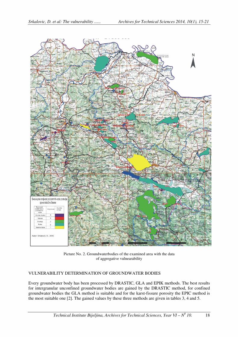
The intergranular porosity groundwater bodies are characterised by relatively simple mechanism of intake recharge, and by a clear movement mechanism, so that these waterbodies are well investigated, in term of geology and the dominant flow directions. The dominant flow directions are depending from the hydrological condition of contour recepients. In table No.2 the groundwater bodies with intergranular porosity are given. Intergranular and karst-fissure groundwaterbodies situation is shown in picture No.2 [7, 8, 9, 10, 11, 12, 13].
Name of waterbody with
karst-fissure porosity Name of waterbody
with intergranular
porosity
Srkalovic, D. et al: The vulnerability ...... Archives for Technical Sciences 2014, 10(1), 15-21
Technical Institute Bijeljina, Archives for Technical Sciences, Year VI – N0 10. 18
Picture No. 2. Groundwaterbodies of the examined area with the data of aggregative vulnearability
VULNERABILITY DETERMINATION OF GROUNDWATER BODIES
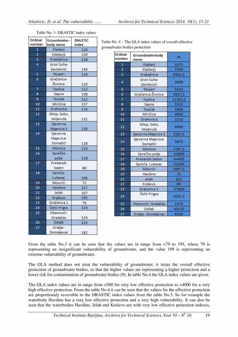
Every groundwater body has been processed by DRASTIC, GLA and EPIK methods. The best results for intergranular unconfined groundwater bodies are gained by the DRASTIC method, for confined groundwater bodies the GLA method is suitable and for the karst-fissure porosity the EPIC method is the most suitable one [2]. The gained values by these three methods are given in tables 3, 4 and 5.
Srkalovic, D. et al: The vulnerability ......
Technical Institute Bijeljina, Archives for
Table No. 3- DRASTIC index values
From the table No.3 it can be seen that the values are in range from representing an insignificant vulnerability of groundwater, and the value 199 is representing an extreme vulnerability of groundwater. The GLA method does not treat the vulnerability of groundwater, it treats the overall eprotection of groundwater bodies, so that the higher values are representing a higher protection and a lower risk for contamination of groundwater bodies [9]. The GLA index values are in range from high effective protection. From the table No.4 it can be seen that the values for the effective protection are proportionaly reversible to the DRASTIC index values from the table No.3. So for example thwaterbody Havdine has a very low effective protection and a very high vulnerability. It can also be seen that the waterbodies Havdine, Jelah and Kraševo are with very low effective protection indexes,
Srkalovic, D. et al: The vulnerability ...... Archives for Technical Sciences 2014, 10(1), 15
Technical Institute Bijeljina, Archives for Technical Sciences, Year VI
DRASTIC index values
Table No. 4 – The GLA index values of overall effective groundwater bodies protection
From the table No.3 it can be seen that the values are in range from <79 torepresenting an insignificant vulnerability of groundwater, and the value 199 is representing an extreme vulnerability of groundwater.
The GLA method does not treat the vulnerability of groundwater, it treats the overall eof groundwater bodies, so that the higher values are representing a higher protection and a
mination of groundwater bodies [9]. In table No.4 the GLA index values are given.
The GLA index values are in range from <500 for very low effective protection to high effective protection. From the table No.4 it can be seen that the values for the effective protection are proportionaly reversible to the DRASTIC index values from the table No.3. So for example thwaterbody Havdine has a very low effective protection and a very high vulnerability. It can also be seen that the waterbodies Havdine, Jelah and Kraševo are with very low effective protection indexes,
echnical Sciences 2014, 10(1), 15-21
Technical Sciences, Year VI – N0 10. 19
The GLA index values of overall effective
to 195, where 79 is representing an insignificant vulnerability of groundwater, and the value 199 is representing an
The GLA method does not treat the vulnerability of groundwater, it treats the overall effective of groundwater bodies, so that the higher values are representing a higher protection and a
In table No.4 the GLA index values are given.
for very low effective protection to >4000 for a very high effective protection. From the table No.4 it can be seen that the values for the effective protection are proportionaly reversible to the DRASTIC index values from the table No.3. So for example the waterbody Havdine has a very low effective protection and a very high vulnerability. It can also be seen that the waterbodies Havdine, Jelah and Kraševo are with very low effective protection indexes,
Srkalovic, D. et al: The vulnerability ......
Technical Institute Bijeljina, Archives for
what can be explained by shallow bedding of thecovering formations [2]. Like the GLA method the EPIK method determines the protectieve index of groundwater bodies, but unlike the GLA method, this one determines the protection index of karstfissure groundwater bodies. The results are shown in table No.5. Table No. 5 – EPIK index values for karst
CONCLUSION
Analysing the above described vulnerability determination methods and synthetising the gained data, a conclusion can be made that: The groundwater bodies Kladanj, Kladanj 1, KraŽivinice according the EPIK meprocesses. The waterbodies Orahovica according the DRASTIC method, while according vulnerability. A explanation is that the DRASTIC method takes in calculation the inclination of slopes and hydraulic conductivity, which significance is very high. The waterbodies Jelah, Havdine is the result of shallow aquifer bedding and permeable covering formations. The waterbodies Toplice, Sjeverna Majevica and Gračanica 1 have a very low vulnerability, what is the result of thickformations and a deep bedding of the aquifer. A conclusion can also be made, that the waterbodies which are in the area of industrial zones and which are in plain regions are more vulnerable karstification processes are intensive
Srkalovic, D. et al: The vulnerability ...... Archives for Technical Sciences 2014, 10(1), 15
Technical Institute Bijeljina, Archives for Technical Sciences, Year VI
what can be explained by shallow bedding of the waterbodies and a absence of aquifer Like the GLA method the EPIK method determines the protectieve index of
groundwater bodies, but unlike the GLA method, this one determines the protection index of karstbodies. The results are shown in table No.5.
EPIK index values for karst-fissure groundwater bodies
The values are in range from 9, which represent low protective characteristics to 34 which represent high protective characteristics of groundwater bodies. table No.5 it can be seen that karstgroundwater bodies on the investigated vulnerable waterbodies (9-19) or waterbodies with no vulnerability (26-34), with the exception of Orahovica waterbody, which has a value of moderate vulnerability.
Analysing the above described vulnerability determination methods and synthetising the gained data, a
Kladanj, Kladanj 1, Krabašnica, Izron - Suha, Stupari andaccording the EPIK method have a high vulnerability, because of inten
Orahovica and Orašje – Domaljevac have a very high vulnerability according the DRASTIC method, while according to the other methods they have low to very low ulnerability. A explanation is that the DRASTIC method takes in calculation the inclination of slopes
and hydraulic conductivity, which significance is very high.
Jelah, Havdine and Kraševo have a high vulnerability according to all methois the result of shallow aquifer bedding and permeable covering formations.
Toplice, Sjeverna Majevica – Domažići, Sprečko polje, Krekanski bazen, Misurihave a very low vulnerability, what is the result of thick unpermeable covering
formations and a deep bedding of the aquifer.
A conclusion can also be made, that the waterbodies which are in the area of industrial zones and which are in plain regions are more vulnerable from those in the hilly areas, except thekarstification processes are intensive.
(Received 20. december 2013, accepted 04
echnical Sciences 2014, 10(1), 15-21
Technical Sciences, Year VI – N0 10. 20
bodies and a absence of aquifer protective Like the GLA method the EPIK method determines the protectieve index of
groundwater bodies, but unlike the GLA method, this one determines the protection index of karst-
The values are in range from 9, which represent low protective characteristics to 34 which represent high protective characteristics of groundwater bodies. From the table No.5 it can be seen that karst-fissure porosity
ed area are either high or waterbodies with no
with the exception of Orahovica waterbody, which has a value of moderate vulnerability.
Analysing the above described vulnerability determination methods and synthetising the gained data, a
Suha, Stupari and Gračanica - thod have a high vulnerability, because of intensive karstification
have a very high vulnerability they have low to very low
ulnerability. A explanation is that the DRASTIC method takes in calculation the inclination of slopes
have a high vulnerability according to all methods, what
ko polje, Krekanski bazen, Misurići unpermeable covering
A conclusion can also be made, that the waterbodies which are in the area of industrial zones and in the hilly areas, except the ones where the
december 2013, accepted 04. january 2014)
Srkalovic, D. et al: The vulnerability ...... Archives for Technical Sciences 2014, 10(1), 15-21
Technical Institute Bijeljina, Archives for Technical Sciences, Year VI – N0 10. 21
LITERATURE
[1] Čičić, S. (2002). Geological composition and tectonics of Bosnia and Hercegovina. [2] Srkalović, D. (2011.). Vulnerability of groundwater bodies in southeastern Bosnia. [3] FIL.B.I.S. (2000). Report about the acomplished MB-2 well, municipality Miričina, Gračanica and NB-
2 municipality Klokotnica, Doboj east. [4] FIL.B.I.S. (2000). Report about the acomplished SPMB well, municipality Stjepan Polje. Gračanica. [5] Žigić, I., Pašić-Škripić, D., Srkalović, D. (2008). Vulnerability study of Tuzla canton groundwater
bodies (hydrogeological part). Bosna-Soil Services company. [6] Pašić-Škripić, D., Žigić, I., Srkalović, D. (2009). Vulnerability of groundwater bodies in southeastern
Bosnia. Zlatibor. 38-th. Waterprotection and water usage conference „Water 2009“. [7] Žigić, I., Pašić-Škripić, D., Srkalović, D. (2008). Groundwater vulneability in intergranular media of
Tuzla basin. Neum. III geology conference of Bosnia and Hercegovina. [8] Žigić, I., Pašić-Škripić, D., Alić, F. (2008). Hydrogeological spring characteristics for Gračanica
watersupply. Neum. III geology conference of Bosnia and Hercegovina. [9] Alić, F., Pašić-Škripić, D., Žigić, I. (2008). Gračanica groundwater bodies characteristics. Sarajevo.
Geological herald 37. [10] Žigić, I., Pašić-Škripić, D., Alić, F., Srkalović, D. ( 2008). Study with programe of hydrogeological
researches for the improval of Gračanica municipality watersupply. Sarajevo. Bureau for water menagement.
[11] Žigić, I., Pašić-Škripić, D. (2009). Vulnerability of groundwater bodies in southwestern part of Tuzla canton. Neum. Bulletin from the 6-th scientifical conference with international participation „Quality 2009“.
[12] Institute for hydrotechnics of faculty for civil engineering in Sarajevo, (2007). Project for B-2a well design in Odžak. Sarajevo. FSD agency for the waterbasin of Sava river.
[13] Geoistrage Sarajevo. (2001). Report about the accomplished test well GM-2 on the aquifer Krčevine, for the watersupply of Mionica by Gradačac. Sarajevo. FSD agency for the waterbasin of Sava river.
Srkalovic, D. et al: The vulnerability ...... Archives for Technical Sciences 2014, 10(1), 15-21
Technical Institute Bijeljina, Archives for Technical Sciences, Year VI – N0 10. 22