68
Final EIR Fairfax Conversion Project February 2012 Chapter 3 – Comments Received and Responses of the Lead Agency 3 - 149 Letter 7 7-1
Final EIR Fairfax Conversion Project
February 2012
Chapter 3 – Comments Received and Responses of the Lead Agency 3 - 149
Letter 7
7-1
Final EIR Fairfax Conversion Project
February 2012
Chapter 3 – Comments Received and Responses of the Lead Agency 3 - 150
Letter 7 Cont’d
7-2
7-3
Final EIR Fairfax Conversion Project
February 2012
Chapter 3 – Comments Received and Responses of the Lead Agency 3 - 151
Letter 7 Cont’d
7-3Cont’d
7-4
7-5
7-6
Final EIR Fairfax Conversion Project
February 2012
Chapter 3 – Comments Received and Responses of the Lead Agency 3 - 152
Letter 7 Cont’d
7-6Cont’d
7-7
7-8
Final EIR Fairfax Conversion Project
February 2012
Chapter 3 – Comments Received and Responses of the Lead Agency 3 - 153
Letter 7 Cont’d
7-8Cont’d
7-9
7-10
Final EIR Fairfax Conversion Project
February 2012
Chapter 3 – Comments Received and Responses of the Lead Agency 3 - 154
Letter 7 Cont’d
7-10Cont’d
7-11
7-12
7-13
7-14
7-15
7-16
Final EIR Fairfax Conversion Project
February 2012
Chapter 3 – Comments Received and Responses of the Lead Agency 3 - 155
Letter 7 Cont’d
7-16Cont’d
7-21
7-20
7-19
7-18
7-17
Final EIR Fairfax Conversion Project
February 2012
Chapter 3 – Comments Received and Responses of the Lead Agency 3 - 156
Letter 7 Cont’d
7-21Cont’d
7-23
7-22
Final EIR Fairfax Conversion Project
February 2012
Chapter 3 – Comments Received and Responses of the Lead Agency 3 - 157
Letter 7 Cont’d
7-23Cont’d
7-25
7-24

Final EIR Fairfax Conversion Project
February 2012
Chapter 3 – Comments Received and Responses of the Lead Agency 3 - 158
Letter 7 Cont’d
7-25Cont’d
7-29
7-26
7-27
7-28
7-30
7-31
Final EIR Fairfax Conversion Project
February 2012
Chapter 3 – Comments Received and Responses of the Lead Agency 3 - 159
Letter 7 Cont’d
Final EIR Fairfax Conversion Project
February 2012
Chapter 3 – Comments Received and Responses of the Lead Agency 3 - 160
LETTER 7: PETER R. BAYE PH.D., BOTANIST – COASTAL ECOLOGIST
Response to Comment 7-1
The commenter objects to the “extraordinarily long” delay between the release of the Notice of Preparation (NOP) for the Fairfax Conversion project in August 2004 and the release of the DEIR in June 2009, stating that such a delay has CEQA consequences. CEQA Guidelines Section 15125 (see also Section 15126.6(e)(2)) states the following regarding the environmental setting as it relates to baseline:
(a) An EIR must include a description of the physical environmental conditions in the vicinity of the project, as they exist at the time the notice of preparation is published, or if no notice of preparation is published, at the time environmental analysis is commenced, from both a local and regional perspective. This environmental setting will normally constitute the baseline physical conditions by which a lead agency determines whether an impact is significant. The description of the environmental setting shall be no longer than is necessary to an understanding of the significant effects of the proposed project and its alternatives.
In order to perform an impact analysis, it is necessary for one to “fix” the baseline conditions of the project site because this enables the lead agency to determine how the site conditions would be changed as a result of the proposed project. The intent of CEQA Guidelines Section 15125 is to provide guidance to lead agencies as to when to “fix” the baseline conditions of the project site. This does not mean that the EIR must evaluate the project’s impacts in light of the baseline conditions at the time of the NOP. Rather, for CEQA projects where long processing delays are experienced, it is appropriate for the lead agency to update the baseline conditions of the project from the time of the NOP so that the impact analyses contained in the EIR represent the actual physical conditions of the project site. This is the approach that CAL FIRE has taken in establishing the baseline conditions for the Fairfax Conversion environmental analysis. The commenter appears to fail to recognize that the delay in processing the Fairfax Conversion project is precisely what was needed to conduct the extensive on-site technical resources analyses, which in many cases, led to time-intensive adjustments to the vineyard plan. For example, the following list of items has been provided as a courtesy to further demonstrate why it was necessary to expend a considerable amount of time in preparing the Fairfax Conversion DEIR:
� Vineyard Plan redesign. Applicant’s early decision to revise the proposed project based largely upon public input. This resulted in a new Erosion Control Plan which was the product of a collaborative effort between the agricultural engineer and registered professional forester for the project, as well as professional subconsultants, including biologists, hydrologists, and archaeologists.
� Preparation of detailed biological resources analysis, including protocol-level surveys for several species. Subsequent to the biological studies conducted on the project site by NCRM in support of a biology section presented in the 2003 Negative Declaration,
Final EIR Fairfax Conversion Project
February 2012
Chapter 3 – Comments Received and Responses of the Lead Agency 3 - 161
Monk & Associates was retained to complete more exhaustive, field-intensive biological analysis of the Fairfax Conversion project site. While to some extent the data provided by NCRM were used anecdotally, Monk & Associates completed independent evaluations and studies for all potentially occurring sensitive biological resources.
Prior to preparing the biological resource constraints analysis report for the DEIR, Monk & Associates researched the following database programs for historic and recent records of special-status plant and animal species (that is, threatened,endangered, rare) known to occur in the region of the project site:
1) The 2009 version of the CDFG Natural Diversity Database, RareFind 3 application (CNDDB 2009);
2) The 2009 version of the California Wildlife Habitat Relationships System for information regarding the potential presence of special-status species;
3) The 2000, 2008, and 2009 Northern Spotted Owl Database maintained by the CDFG; and
4) The California Native Plant Society’s (CNPS) Inventory of Rare and Endangered Plants of California (CNPS 2001). All special-status species records were compiled in tables.
� Preparation of a Formal U.S. Army Corps of Engineers’ Wetland Delineation. A formal wetland delineation of the project site was conducted on February 15, May 1, 2, 3, 4, and 5, 2006 by Mr. Geoff Monk and Ms. Isabelle de Geofroy, on June 6, 7 and 8, 2006 by Mr. Monk and Ms. Kimberly DeBriansky, and on June 14 and 15, 2006 by Ms. de Geofroy and Ms. Stephanie Scolari. The wetland delineation was conducted according to the Corps’ 1987 Wetlands Delineation Manual. Vegetation, hydrology, and soils information were recorded on data sheets. Data points, potential wetlands, and other features were mapped using a Trimble Pro-XT Global Positioning System (GPS) having sub-meter accuracy. A preliminary wetlands delineation map was made from the GPS files using ArcMap 9.1. All spatial data were projected into the California State Plane, NAD 83 (feet) coordinate system, Zone 2. Using GPS technology, the boundaries (within 30 inches) of each delineated wetland was transferred to a LiDAR topography map of the project site. On November 2 and 16, 2006, the Corps field verified the extent of their jurisdiction on the project site pursuant to Section 404 of the Clean Water Act. Monk & Associates incorporated the Corps mapping additions and edits onto its wetlands map and subsequently submitted the final Wetlands Map of the project site to the Corps on November 28, 2006. The Corps formally assumed the extent of its jurisdiction over the project site on December 4, 2007.
� Preparation of detailed hydrology and erosion analysis, which included field surveys and detailed modeling processes. O’Connor Environmental Incorporated (OEI) conducted extensive on-site surveys in support of the Erosion and Hydrological Effects Analysis prepared for the Fairfax Conversion project. Both of these reports were completed in May 2008. Field surveys in support of the May 2008 reports for
Final EIR Fairfax Conversion Project
February 2012
Chapter 3 – Comments Received and Responses of the Lead Agency 3 - 162
the project include gully surveys in 2005 to estimate erosion rates. Additional field surveys were performed in April 2007, during which three additional gully erosion locations were observed affecting existing temporary or abandoned roads. The data from these surveys were used as inputs to the Revised Universal Soil Loss Equation - 2 (RUSLE2), which is the latest refinement of the USLE method, which tended to overestimate erosion rates in upland settings such as the project area. The RUSLE2 model was used by OEI to develop quantitative estimates of erosion rates by surface processes for the proposed vineyards, existing vineyards on adjacent properties, and existing grasslands. Erosion rates from existing forests in the project area were also estimated. These quantitative erosion rates were used in the sediment source analysis for the Patchett Creek watershed to evaluate potential changes in water quality resulting from the project.
� Refinement of Erosion Control Plan/Vineyard Plan based upon the findings in the technical reports. Utilizing the results of the above-noted technical analyses performed for the Fairfax Conversion project by various experts, the Erosion Control Plan and associated Vineyard Plan went through several iterations, so as to ensure that impacts to the on-site resources are being avoided to the maximum extent feasible. This includes avoidance/preservation of identified archaeological resources and biological resources (e.g., thin-lobed horkelia, Annapolis Manzanita, jurisdictional waters of the U.S.).
� Preparation of detailed archaeological resources report, including field surveys and analysis of data collected on-site. As stated on page 3.5-18 of the DEIR, based on the sites identified by Maximillian Neri’s fieldwork conducted for the project site in 2001, a second field investigation was conducted by Tom M. Origer of Tom Origer & Associates. In addition, archival research was conducted using the State Archives, Sonoma County Recorder’s Office, Sonoma County Assessor’s Office, Sonoma County Courts, County Library History Annex, communication with local residents, examination of old county maps and atlases, census data, and USGS topographic maps.
Fieldwork was conducted by Origer & Associates on September 8th through 15th,2006, and September 26th through 29th, 2006 for Artesa Site-02, -03, -05, and -06H. Previously recorded prehistoric archaeological resources Artesa Site-02, -03, and -05 were subjected to investigative procedures outlined in the DEIR. As further noted on page 3.5-18 of the DEIR, Origer & Associates conducted a supplemental investigation on April 24 and 25, 2008 of the lumber mill site (cf. Report on Supplemental Studies for the Artesa-Fairfax Project, Annapolis, Sonoma County, dated May 5, 2008). Recording of the lumber mill sites was facilitated by thorough surface inspection. During the ground truthing process, which used a metal detector, probe, and pick and shovel, any archaeological deposits discovered were incorporated into the resource field sketch maps, and notes were taken. Interviews with knowledgeable local residents of the general area added information about the lumber milling activities, especially within the project site. All of the information was incorporated into the site
Final EIR Fairfax Conversion Project
February 2012
Chapter 3 – Comments Received and Responses of the Lead Agency 3 - 163
recording documents. Archival research also added information incorporated onto the DPR 523 forms.
Intensive resource analyses that have been completed since 2004 are elaborated upon below.
Biological Surveys
Rare Plant Surveys
Special-status plant surveys were conducted by Monk & Associates biologists Ms. Isabelle de Geofroy and Ms. Sarah Lynch on April 25, 26 and 27, 2006; by Ms. de Geofroy and Ms. Stephanie Scolari on June 13, 14 and 15, 2006; and again by Ms. de Geofroy and Ms. Lynch on August 8, 9 and 10, 2006. The surveys followed methods prescribed by the USFWS (Cypher 2002, USFWS 1996), CDFG (2000), and CNPS (2001) published survey guidelines. These guidelines state that special-status surveys should be conducted at the proper time of year when special-status and locally significant plants are both evident and identifiable. The guidelines also state that the surveys be floristic in nature with every plant observed identified to species, subspecies, or variety as necessary to determine their rarity status. Finally, these surveys must be conducted in a manner that is consistent with conservation ethics and accepted plant collection and documentation techniques. Following these guidelines, surveys were conducted during the months when special-status plant species from the region are known to be evident and flowering. All areas of the project site were examined by walking systematic transects through potential habitat, and by closely examining any existing microhabitats that could potentially support special-status plants.
Nearly all plant species found on the project site were identified to species. All were identified to the level needed to determine whether they qualify as special-status plants. A list of all vascular plant taxa encountered within the project site was recorded in the field during each survey. Plants that needed further evaluation were collected and keyed in the lab. Final determinations for collected plants were made by keying specimens using standard references such as The Jepson Manual (Hickman 1993).
Northern Spotted Owl Surveys
The northern spotted owl survey regimen was developed by Mr. Geoff Monk, certified wildlife biologist, in conjunction with other experienced Monk & Associates staff. The survey regimen was prepared after carefully reviewing appropriate northern spotted owl survey protocols (details provided below) and then walking the entire project site to develop an understanding of the accessibility opportunities and determining the most likely areas for detections during night time auditory surveys. During the daytime scoping surveys, Monk & Associates also looked for direct and indirect evidence of northern spotted owl occupation of the project site. Evidence of occupation would include multiple visual sightings of this owl species, responses from calling activities, and/or the presence of pellets, or molt feathers. All larger trees were examined for suitable nesting cavities, and the forest floor where open (the project site is characterized by a brushed-in forest floor) was examined for the presence of white-wash, molt feathers, and other indicators of presence.
Final EIR Fairfax Conversion Project
February 2012
Chapter 3 – Comments Received and Responses of the Lead Agency 3 - 164
Pursuant to USFWS’s survey protocols, Monk & Associates biologists conducted auditory (calling) surveys by walking throughout the project site along the forest/meadow edges, along all accessible roadways and paths, and within any stands of (more) mature timber. Off project site areas were accessed via publically assessable roads. Electronic recordings were amplified at calling stations of northern spotted owls that were provided by the USFWS1.
The project site was thoroughly logged likely sometime between 1940 and 1960, and thus it does not support an open understory. Rather, there is a thick, brushy condition that now has an enveloping overstory of trees over most of the timbered portion of the project site. Thus, nocturnal accessibility for surveys was limited to a degree by impenetrable brush. Regardless, Monk & Associates endeavored to reach “most likely areas.” This was accomplished by flagging routes through the forest in the daytime to optimal calling positions. During nighttime surveys, Monk & Associates followed flag lines to the established calling stations in areas regarded as “most likely” to support northern spotted owls. Flag lines were followed as quietly as possible using low intensity flashlights. Upon reaching designated calling locations, lights were turned off and then Monk & Associates biologists remained at the calling station quietly for at least 15 minutes prior to commencing with recorded calls. The pre-listening method was actually the most successful method for detections of other owl species on the project site.
Along roadways, pathways, and meadow edges, calling surveys were conducted on foot by pausing at approximately 50 yards intervals and playing various calls of the northern spotted owl. At all calling stations, the recording was amplified to a volume that could be heard a minimum of ¼ mile away. During each calling effort, the recording was played for 3 to 7 calls followed by the observer listening for a response for one to five minutes. This process was repeated for at least 15 minutes before moving on to the next calling station. Field notes included weather at the time of each survey, description of survey route, the survey start and stop time and any owl responses or observations. Positions of any owl detections were marked on a project maps.
Monk & Associates concluded that suitable conditions for resident northern spotted owls do not occur on the project site. Northern spotted owls typically require closed canopy forest that supports a relatively open understory. These owls are relatively weak fliers and do not readily maneuver through heavy understory cover; nor do they typically crash through heavy brush in pursuit of prey. Optimal conditions for northern spotted owls include old growth forests with open understories, and edge communities around such forests. The project site contains no such resources.
Natural succession that occurred after the project site was clear cut included early colonization by dense shrub species such as hairy manzanita (Arctostaphylos columbiana), Annapolis manzanita (A. stanfordiana x A. manzanita), California huckleberry (Vaccinium ovatum) and coast whitethorn (Ceanothus incanus). Tan oak (Lithocarpus densiflorus var. densiflorus) also established in gaps in the brushed forest, as well as Douglas-fir (Pseudotsuga menziesii var. menziesii) and clusters of redwoods (Sequoia sempervirens) resprouted from cut stumps. At present, the forest vegetation on the project site consists primarily of a heavily brushed
1 http://www.fws.gov/oregonfwo/Species/Data/NorthernSpottedOwl/Recovery/Library/Default.aspx#Files
Final EIR Fairfax Conversion Project
February 2012
Chapter 3 – Comments Received and Responses of the Lead Agency 3 - 165
understory with an overstory of tan oak and Douglas-fir, with interspersed redwood. Only two (n=2) old-growth trees exist on the site, both of which are to be preserved and protected in permanent preserves. Habitat conditions do not provide nesting or foraging conditions that would support northern spotted owls.
Surveys that have been conducted for northern spotted owl on the project site are detailed below. In 2006 and 2007 Monk & Associates’ biologists, conducted a two-year protocol survey for the northern spotted owl (Strix occidentalis caurina) according to USFWS’ then valid 1992 Northern Spotted Owl Survey Protocol2. Northern spotted owls were not identified on the proposed project site during the two year survey. While a single year of survey could be conducted pursuant to the USFWS’s 1992 survey protocol, even then the USFWS encouraged completion of a two-year survey “to provide a higher likelihood of accurately determining presence or absence of spotted owls”. Out of an abundance of caution, the applicant chose to conduct the more rigorous two year survey to ensure that the proposed project would not impact the northern spotted owl. Surveys in 2006 and 2007 were conducted by Monk & Associates biologists that have direct experience with northern spotted owls.
During the 2006 survey period, Monk & Associates conducted night surveys for the northern spotted owl on six separate dates. Surveys were conducted on April 27, May 4, June 5, and June 10, July 26, August 2. In 2007, Monk & Associates’ biologists conducted additional northern spotted owl surveys on three separate dates: April 26, July 12, and August 2, 2007, as required by the USFWS for a two-year survey.
Because the validity period of the 2-year survey using the 1992 survey protocol only extended through 2009, in 2010 Monk & Associates once again conducted northern spotted owl surveys on the project site. On February 23, 2010, USFWS published a revised draft northern spotted owl survey protocol3. In accordance with the revised 2010 draft survey protocol, Monk & Associates completed seven northern spotted owl surveys in 2010. Six nocturnal and a daytime stand survey were completed in the required timeframe for conducting the surveys. In 2010, M&A completed nocturnal surveys on the project site on May 5-6, May 26-27, June 9-10, June 23-24, July 14-15, July 26-27, and August 10-11 survey dates. The diurnal stand survey was completed on the June 9-10 survey dates. Northern spotted owls were not detected during these surveys.
Protocol surveys continued in 2011 using USFWS’ final revised survey protocol4. Seven required surveys (six nocturnal and a daytime stand survey) were completed by August 2011 within the required timeframes for completing surveys. Survey dates included April 5-7, April 26-28, May 25-27, June 9-10, June 15-17, June 24-25, June 29 (diurnal stand survey), July 14-17, July 27-29, and finally on August 9 -11. During these surveys no northern spotted owls were detected on the project site. The nocturnal survey conducted on July 14-17 detected a northern spotted owl just southwest of the project site. This owl was called from a known “activity
2 USFWS (U.S. Fish and Wildlife Service) 1992. Protocol for Surveying Proposed Management Activities that may Impact Northern Spotted Owls. March 7, 1991. Revised March 17, 1992. 3 USFWS (U.S. Fish and Wildlife Service). 2010. Draft Protocol for Surveying Management Activities That May Impact Northern Spotted Owls. February 18, 2010. 4 USFWS (U.S. Fish and Wildlife Service). 2011. Protocol for Surveying Management Activities That May Impact Northern Spotted Owls. February 2, 2011.
Final EIR Fairfax Conversion Project
February 2012
Chapter 3 – Comments Received and Responses of the Lead Agency 3 - 166
center5” located approximately 0.7 miles southwest of the project site (SON0043 and SON0058). Two subsequent surveys after initial detection of this northern spotted owl without a follow-up detection demonstrated that northern spotted owls had not established a new activity center any closer to the the project site than the existing known activity centers 0.7 miles southwest of the project site.
After reviewing project site maps and survey data CAL FIRE biologist Mr. Robert Motroni concluded that it appeared that no new northern spotted owl activity center had been established any closer to the project site than the existing known northern spotted owl activity centers 0.7 miles southwest of the project site (sites SON0043 and SON0058). CAL FIRE concluded that the proposed project would have “no effects” on the northern spotted owl; however, CAL FIRE requested that M&A seek technical assistance with the USFWS to confirm this conclusion.
On September 12, 2011 Monk & Associates biologist Mr. Geoff Monk and North Coast Resource Management biologist Mr. Jeff Longcrier met with Mr. Steve Krammer and Mr. Bill McIver of the USFWS to examine the northern spotted owl survey data and findings. Both Mr. Krammer and Mr. McIver are experts with northern spotted owls and routinely consult with CAL FIRE regarding timber harvest plans. Like CAL FIRE biologist Mr. Robert Motroni, Mr. Krammer concluded that “USFWS would not consider this an effect project,” and also that USFWS “did not have a lot of concern” regarding impacts to the northern spotted owl based upon their preliminary review of the survey data.6 They concluded that the survey data shows that no new northern spotted owl activity center has been established any closer to the project site than the existing known northern spotted owl activity centers 0.7 miles southwest of the project site. Mr. Krammer requested that Monk & Associates send in the full survey report and include descriptions of the habitat to be removed. In addition, USFWS stated that the project should include “Spot Check Surveys” (follow-up) in survey years 3 and 4 pursuant to the revised 2011 Northern Spotted Owl Survey Protocol. If a northern spotted owl subsequently establishes and activity center on or nearer to the project site than 0.7-miles then verification of adequate nesting and roosting habitat would be required and would be verified through further consultation with the USFWS.
Owing to heavily brushed understories and second growth conditions, it is Monk & Associates’ conclusion that at this time, neither the project site nor the areas immediately surrounding the project site support habitat that would be suitable for occupation by northern spotted owls. CEQA requires analysis of the current condition of the subject parcel and we believe the DEIR adequately addresses the current project site conditions and potential impacts to northern spotted owls. Northern spotted owls were not detected on the project site over the four years of surveys. Although an incidental sighting of a northern spotted owl occurred south of the project site in a July 2011 survey, subsequent surveys showed that the owl was not a resident and was called from one of the two established activity centers southwest of the project site.
5 Activity Center is defined in the USFWS’s 2011 Protocol for Surveying Proposed Management Activities that May Impact Northern Spotted Owls as follows: This area represents the area surrounding concentrations of 'the best of' detections such as nest stands, stands used by roosting pairs or territorial singles, or areas of concentrated nighttime detections.” 6 Personal communication between Geoff Monk of Monk & Associates, Jeff Longcrier of North Coast Resource Management, and Steve Krammer and Bill McIver of the USFWS, Arcata, California, September 12, 2011.
Final EIR Fairfax Conversion Project
February 2012
Chapter 3 – Comments Received and Responses of the Lead Agency 3 - 167
The northern spotted owl analysis and conclusions presented in the EIR are based on current, accurate and reliable data. Based upon the current baseline conditions of the project site, the proposed project will not result in significant adverse impacts to the northern spotted owl. Furthermore since the project site supports habitat that is not suitable for northern spotted owls, and they have not been detected on the project site during four years of survey, there is no cumulative impact to this owl species. As such no additional mitigation measures are warranted for this species.
Northern Red-Legged Frog and California Red-Legged Frog Surveys
Northern red-legged frog and California red-legged frog surveys were completed by Monk & Associates biologists in all aquatic habitats on the project site in 2008, 2009, and 2010. Red-legged frog or their eggs or larvae have never been observed on or adjacent to the project site.
In 2008, two full (all aquatic habitats) project site diurnal surveys and two full project site nocturnal surveys were conducted for the northern red-legged frog. Formal amphibian surveys were conducted in all tributaries and the man-made pond by Mr. Monk and Ms. Melisa Anderson, both federally permitted 10(a)(1)(A) California red-legged frog biologists, on March 20 and 21, 2008. These surveys were repeated by Mr. Monk and Mr. Geoff Thomas (Mr. Thomas is also a 10(a)(1)(A) California red-legged frog biologist) on March 25 and 26, 2008. Surveys were conducted by slowly walking along tributaries and using high powered binoculars to scan ahead looking for frogs both in wetted areas and areas adjacent to wetted areas (i.e. shorelines and stream banks). Auditory detection was considered paramount during surveys. Accordingly, every 20 meters while conducting surveys along tributaries biologists paused quietly for 3 to 10 minutes in an attempt to detect amphibians via vocalizations. Similar methods were used to survey the man-made pond on the project site. As this pond is very small being only about 30 feet in diameter, it was a relatively simple process to thoroughly survey this pond. Northern red-legged frogs or California red-legged frogs were not found during these surveys. The only frogs found during surveys were foothill yellow-legged frogs in Patchett Creek and Pacific tree frogs [the tree frog clade is now recognized as Sierra tree frog (Pseudacris sierra)] in the small man-made pond.
After completing surveys for northern and California red-legged frog in 2008, Monk & Associates biologists continued conducting investigations and surveys for California red-legged frogs. Until California red-legged frog critical habitat was proposed for revision by USFWS in September 20087, the project site had been regarded as within the range of the northern red-legged frog. The California red-legged frog was typically regarded as occurring from Sonoma County in northern California south to northern Baja California, and inland through the northern Sacramento Valley into the foothills of the Sierra Nevada Mountains, south to Tulare County, and possibly Kern County. The northernmost extent of its confirmed range was the Russian River. In contrast the northern red-legged frog is regarded as occurring from Vancouver Island, British Columbia, Canada, south along the Pacific coast west of the Cascade ranges to northern
7 USFWS 2008. Endangered and Threatened Wildlife and Plants; Revised Critical Habitat for the California Red-Legged Frog (Rana aurora draytonii) Federal Register 50 CFR Part 17 Proposed Rule: September 16, 2008 (Volume 73, Number 180)] Page 53491-53540].
Final EIR Fairfax Conversion Project
February 2012
Chapter 3 – Comments Received and Responses of the Lead Agency 3 - 168
California (northern Del Norte County). Formerly, red-legged frogs found from southern Del Norte to northern Marin County (the project site lies within this range) were believed to exhibit intergrading characteristics of both the northern and California red-legged frog8. Relatively recently, Schaeffer et al. reported in a recently published Proposed Rule9 that re-proposed critical habitat of the California red-legged frog that data obtained from a 2004 genetics study determined that R. aurora actually consists of two species, the northern red-legged frog (Ranaaurora) and the California red-legged frog (Rana draytonii). Subsequently, on June 18, 2009 the USFWS prepared a letter for the California Department of Forestry and Fire Protection regarding the Extension of Regulatory Protection to the Federally Listed California Red-Legged Frog (Rana draytonii) in Mendocino County. In that letter, the USFWS discusses the genetic analyses and the range changes for the California red-legged frog in Mendocino County. It should be noted that on March 16, 2010, the USFWS issued the final rule on California red-legged frog critical habitat10. The final rule reflected the genetic analyses that determined that the California red-legged frog is now known to occur in Mendocino County. The final rule also confirms that project site remains well outside designated critical habitat of the California red-legged frog.
Owing to the populations of California red-legged frog now recognized in Mendocino County, it is now known that the range of the California red-legged frog extends northward from its traditionally recognized coastal habitats in Marin and Sonoma Counties to Mendocino County. What remains unknown is whether both species occur in the overlap area between northern Sonoma and Southern Mendocino Counties.
After the California red-legged frog population was identified in central Mendocino County, Monk & Associates determined that a formal California red-legged frog site assessment should be prepared and submitted to the USFWS. A formal assessment study was completed in accordance with the Revised Guidance on Site Assessments and Field Surveys for the California Red-Legged Frog 11 (herein referred to as Revised Guidance) for the proposed project site. This assessment was submitted to USFWS on April 7, 2009. M&A’s Site Assessment report requested authorization from USFWS to conduct protocol level presence/absence surveys for the CRLF. After further discussing the proposed project with Mr. Andrew Raabe and Mr. Chris Nagano at the Sacramento Endangered Species Office of the USFWS, M&A received authorization from the USFWS to conduct California red-legged frog protocol surveys via a letter signed by Mr. Nagano dated May 20, 2009.
Following the guidelines prescribed in USFWS’s August 2005 Revised Guidance on Site Assessments and Field Surveys for the California Red-Legged Frog (survey protocol), M&A
8 USFWS (U. S. Fish and Wildlife Service). 2006. Designation of critical habitat for the California red-legged frog, and special rule exemption associated with final listing for existing routine ranching activities; final rule. 50 CFR Part 17. Federal Register, Volume 71, No. 71, pages 19243-19346. April 13. 9 USFWS 2008. Endangered and Threatened Wildlife and Plants; Revised Critical Habitat for the California Red-Legged Frog (Rana aurora draytonii) 50 CFR Part 17 Proposed Rule. Federal Register Volume 73, Number 180, pp. 53491-53540. September 16. 10 USFWS (U.S. Fish and Wildlife Service) 2010. Endangered and Threatened Wildlife and Plants: Revised Designation of Critical Habitat for California Red-Legged Frog; Final Rule. Federal Register 50 CFR Part 17 March 17, 2010 (Volume 75, Number 51) Page 12815-12864. 11 USFWS (U.S. Fish and Wildlife Service). 2005. Revised guidance on site assessments and field surveys for the California red-legged frog. August 2005. 26 pps.
Final EIR Fairfax Conversion Project
February 2012
Chapter 3 – Comments Received and Responses of the Lead Agency 3 - 169
searched the California Department of Fish and Game’s most current version of the Natural Diversity Database (CNDDB) for records for this frog within ten miles of the project site. In addition, M&A conducted two diurnal and four nocturnal surveys prior to July 1, 2009 (breeding season) and one diurnal and one nocturnal survey after July 1, 2009 (non-breeding season). All M&A biologists conducting the surveys have extensive experience with the California red-legged frog and are federal 10(a) (1) (A) permitted biologists authorized to work with this species. M&A’s principal biologist Mr. Geoff Monk participated in all surveys, each time including one or two other assistants from M&A. California red-legged frogs were not found during any survey on and adjacent to the project site.
M&A conducted extensive biological survey work on the project site in 2010 including follow-up California red-legged frog surveys. Mr. Geoff Monk, Ms. Jessica Pouder and/or Brian Spirou conducted diurnal surveys in all aquatic habitats on the project site on May 7, May 28, June 25, and July 16. By July 16th, 2010 Patchett Creek was completely dry in its uppermost reaches on the project site and only remnant, relatively small pools remained on the lower reaches of this creek. The man-made pond was completely dry by July 16, 2010. Northern red-legged frogs or California red-legged frogs, their eggs or larvae were not detected during these surveys. Spot surveys in Patchett Creek were again conducted on the project in May and June 2011. Again no California red-legged frogs were observed. Also on April 27, 2011, M&A biologists Mr. Monk and Mr. Spirou conducted a survey down Patchett Creek with intensions of following it from the top of the watershed on the northeast corner of the project site all the way down to the Wheatfield Fork of the Gualala River. After encountering a massive area of metagreywacke sandstone cliffs consisting of 3 successive, approximately 80-foot vertical drops in the creek bed, M&A was unable to complete the survey all the way to the Wheatfield Fork of the Gualala River.
Nesting Raptors and General Wildlife Surveys
North Coast Resource Management conducted raptor nesting surveys in 2001. Nesting raptors were not found on or near the project site. Similarly, Monk & Associates conducted raptor nesting surveys on the project site in. Raptor nesting surveys led by Mr. Monk on the proposed project site were thoroughly planned and executed in a manner that would maximize opportunities for locating nesting raptors. M&A’s systematic nesting surveys failed to identify any nesting raptor species on the project site in 2006, 2010, and 2011.
Nesting raptors were not found during these surveys. The second growth conditions of the site combined with heavily brushed understories provides less than optimal conditions for nesting raptors.
In 2006, Monk & Associates biologists Mr. Geoff Monk, Ms. Kimberly Debriansky, Ms. Melisa Anderson, Ms. Sarah Lynch, and Ms. Isabelle de Geofroy conducted systematic raptor nesting surveys of the project site in the first week of April and the second week of May. All portions of the project site were examined. General wildlife surveys were also conducted on June 7 and 8, 2006, September 19, 2006, October 12, 2006, and December 11, 2006. It should be noted that during all surveys of the project site conducted by Mr. Monk and others from Monk &
Final EIR Fairfax Conversion Project
February 2012
Chapter 3 – Comments Received and Responses of the Lead Agency 3 - 170
Associates that all wildlife species observed (tracks, individuals, or other sign) were noted in project site notebooks.
In 2010, based upon recommendation of the California Department of Fish and Game, M&A once again conducted systematic diurnal raptor surveys over the project site on May 6-7, May 27-28, June 10-11, and June 24-25. In 2011 systematic surveys on the project site were again completed on April 6, April 27, and May 26 by Mr. Monk, Mr. Brian Spirou, and Ms. Sadie McGarvey all experienced M&A biologists.
Survey methods included systematic walking transects along predetermined compass bearings spaced approximately 100 to 200 feet apart. Due to the rugged terrain and dense undergrowth, occasional transect deviations occurred. When deviating from the predetermined transect bearings, secondary bearings were taken in the field to enable the surveyors’ accurate return to the initial transect once the obstacle was navigated. Fair weather persisted during all survey dates. Surveyors conducted informal playback surveys while walking diurnal raptor nesting transects. An Edge Expedite® Mighty Predator Electronic Caller with broadcast speaker was used to play alarm calls of Northern goshawk (Accipiter gentilis), Cooper’s hawk (Accipitercooperii), and sharp-shinned hawk (Accipiter striatus) at numerous, but random, points along transects. The broadcast vocalizations were obtained from the Cornell Laboratory of Ornithology’s Macaulay Library (http://macaulaylibrary.org/index.do). M&A decided which species’ alarm call to play based on the prevalent habitat of each informal calling station, but an effort was made to ensure an equal proportion of broadcast calling occurred for each species.
Surveyors also searched for nests or nesting evidence while walking the diurnal transects. Nest searching involved scanning trees for signs of perched raptors and their nests, as well as searching the ground for indirect evidence of nesting. Such evidence includes the presence of fresh white-wash (i.e., excrement) in a tree or on the ground near a burrow; adult molt feathers, and/or down or feathers from young and/or adults located in relatively high concentrations in the vicinity or entrance of a suitable burrow; and evidence of kills (i.e., plucking posts and solitary kills) or pellet piles indicating use of a tree or locality by nesting raptors.
During formal raptor nesting surveys, surveys were conducted for other special-status species owing to the opportunities provided by the systematic coverage of the project site. Thus general wildlife surveys for birds, reptiles and amphibians were conducted simultaneously. Lists of all wildlife encountered were kept in project notebooks. Amphibian surveys were conducted by walking stream courses and examining larvae in pools, and searching for adults. Logs in the forest and in meadows were temporarily dislodged for scanning underneath such logs for amphibians, reptiles, and rodents. All logs were carefully restored to their prior placement upon completion of the examinations. Leaf nests or “needle nests” were also searched for in larger stands of timber for the potential presence of red tree vole (Arborimus pomo), a designated species of special concern known from mature forests on the north coast of California. Under observed leaf nests, evidence of pine needle harvesting, and other signs that this vole species could be present such as droppings, stick accumulations, etc. were searched for. Monk & Associates lead biologist Mr. Geoff Monk obtained experience surveying for red tree voles in the past while working as biologist at the Bureau of Land Management, in the Ukiah District Office.
Final EIR Fairfax Conversion Project
February 2012
Chapter 3 – Comments Received and Responses of the Lead Agency 3 - 171
Fisheries Analysis
The August 2007 Fisheries Assessment conducted for the proposed project by Inland Ecosystems of Reno, Nevada (See Appendix J of the DEIR) consisted of a review of project environmental documentation with specific reference to identifying potential impacts to listed coldwater salmonids, particularly steelhead trout (Oncorhynchus mykiss irideus), downstream of the project site. It should be noted that on April 27, 2011, M&A biologists Mr. Monk and Mr. Spirou conducted survey down Patchett Creek with intensions of following it from the top of the watershed on the northeast corner of the project site all the way down to the Wheatfield Fork of the Gualala River. After encountering a massive area of metagreywacke cliffs consisting of 3 successive, approximately 80-foot vertical drops in the creek bed, M&A was unable to complete the survey all the way to the Wheatfield Fork of the Gualala River. This constitutes a significant barrier to any wildlife confined to the aquatic prism of the creek including all fish species.
Owing to careful and prudent use of rainfall as the exclusive source of irrigation water which will be collected in periods of major storms when flow in all creeks/rivers are highest, no adverse hydrological impacts are expected in lower watersheds where fish live. Also owing to exceptional Best Management Practices that include the construction of desilting basins at the lowest points on the project site, no deleterious stream condition will be created in the Wheatfield Fork of Gualala River and lower watersheds by silt runoff from the project site. Finally, through judicial use and timing of application any treatments applied to vineyards that will occur when there is no stormwater runoff event in the forecast, no downstream contamination is expected to result from vineyard management activities.
Yellow Warbler Surveys (See Response to Comment 1-16)
In accordance with recommendations from the California Department of Fish and Game, Monk & Associates commenced completion of nesting yellow warbler surveys on the project site in June and July 2010. Surveyors conducted informal playback surveys while walking yellow warbler nesting transects. An Edge Expedite® Mighty Predator Electronic Caller with broadcast speaker was used to play yellow warbler calls at numerous, but random, points along suitable nesting habitats on the projects site. The broadcast vocalizations were obtained from the Cornell Laboratory of Ornithology’s Macaulay Library (http://macaulaylibrary.org/index.do).
Four two-day surveys were conducted on the project site in 2010. M&A completed yellow warbler nesting surveys on June 10-11, June 24-25, July 15-16, and July 28-29, 2010. Complete project surveys in all suitable nesting habitats occurred on each survey day. M&A did not find any evidence of nesting or non-nesting yellow warblers on the property during the 2010 surveys.
During surveys all warblers heard and/or observed were recorded in notebooks. In addition, all birds observed nesting on the project site (during any and all surveys) were recorded in project notebooks. M&A determined that orange-crowned warblers (Vermivora celata) and Wilson’s warblers (Wilsonia pusilla) are common nesters on the project site. Other warblers observed during our surveys included black-throated gray warbler (Dendroica nigrescens) and MacGillivray's warbler (Oporornis tolmiei). Yellow warblers were not detected during any survey and thus yellow warblers are not believed to nest on the project site.
Final EIR Fairfax Conversion Project
February 2012
Chapter 3 – Comments Received and Responses of the Lead Agency 3 - 172
Cultural Resources
The following is a summary of the additional cultural resources surveys that have been performed on-site since the release of the DEIR and discussed in detail in Chapter 3.5, CulturalResources, of the Partially Recirculated DEIR for the Fairfax Conversion project, as well as Response to Comment 13-5 of this Final EIR.
July 2009 Surveys
Since the release of the DEIR for public review, a few previously unrecorded archaeological resources were identified during the June 2009 Pre-Harvest Inspection (PHI), which is a field meeting that is part of the Timber Harvest Plan (THP) process, involving regulatory agencies (Please refer to Response to 13-5 for further discussion.). During an additional follow-up field visit to the project site by CAL FIRE archaeologist Chuck Whatford and Reno Franklin, Tribal Historic Preservation Officer (THPO) of the Kashia Band of Pomo Indians of Stewarts Point Rancheria, another previously unidentified archaeological site was found, containing obsidian and chert flakes. Subsequent to this, Assistant THPO Walter Antone attended a follow-up PHI with Tom Origer of Tom Origer & Associates and Chuck Whatford, during which time the three additional locations were assessed. Based upon the findings made during the above-described field inspections, CAL FIRE Archaeologist Chuck Whatford determined that the 2001 archaeological survey of the project area was not sufficient for the proposed conversion project and requested that another archaeological survey of the project area be performed. As a result, Origer & Associates conducted a systematic archaeological field survey, which resulted in comprehensive survey coverage of the entire project site conducted on July 16 and 17, 2009, with the exception of two areas that were subjected to mixed-strategy survey due to the fact that they were covered by dense patches of brush (see more on this below under “November 2010 Surveys”). “Mixed-strategy” survey refers to survey efforts of varying intensity based on the sensitivity of the terrain. Where environmental factors suggest higher probability for archaeological sites (land is relatively level, soils drain well), survey corridors are more tightly spaced. Where slopes are steep (e.g. 30% or greater) corridors are more widely spaced.
The results of Origer & Associates’ archaeological survey and site evaluations are presented in the report prepared for CAL FIRE review and approval, entitled “An Archaeological Survey Report for the Artesa/Fairfax Timber Harvesting Plan,” dated August 6, 2009. The reviewing CAL FIRE archaeologist provided comments on this report that Origer & Associates incorporated into the revised report cited above. The reviewing CAL FIRE archaeologist provided internal comments on this report, after which Origer & Associates produced a revised report, dated May 6, 2010.
The purpose of the July 2009 survey performed by Origer & Associates was to inspect the three additional locations identified during the PHI, as well as to survey all portions of the property where timberland conversion activities and/or timber harvesting are planned. Special attention was paid to those areas where archaeological specimens were found during the PHI. An intensive surface survey strategy was employed by surveying in a zigzag pattern on transects approximately 20-25 meters wide. As noted above, dense vegetation prevented intensive survey coverage in two portions of the project area. In these areas where the presence of very dense
Final EIR Fairfax Conversion Project
February 2012
Chapter 3 – Comments Received and Responses of the Lead Agency 3 - 173
vegetation made conducting an intensive archaeological survey impractical, a mixed strategy survey was conducted by making forays into the brush, where possible, to examine the ground surface.
November 2010 Surveys
In consideration of public comment on the DEIR, CAL FIRE requested an intensive archaeological field survey of the two densely vegetated areas, which were surveyed using mixed-strategy survey techniques during the July 2009 field survey. The requested additional survey was conducted on November 10th and 11th, 2010, and focused upon a 5-acre block in the northern portion of the project area and a 15-acre block in the southern portion of the project area. To intensively survey these two dense brush locations, Origer & Associates initially proposed the use of a backhoe to flatten brush and create corridors in which the field crew could closely inspect the exposed the ground surface. After a few initial forays into the dense brush with the backhoe, it quickly became apparent that this method could not be employed without creating ground disturbance that would require a Native American monitor to be present per CAL FIRE directives. Consequently no further use of the backhoe was made during the remainder of the survey effort.
Transects were subsequently made through the brush with loppers and other hand tools to clear the brush in locations with somewhat less dense vegetation. In the northern dense brush area (~5 acres), transects no more than 15 meters apart were traversed by a combination of clearing dense brush and crawling, as needed, to complete an intensive survey of the entire five-acre area. The same methods were applied to the southern dense brush area (~15 acres) with less success. Although the original intention was to conduct an intensive survey of the entire 15-acre area, the presence of very dense brush made this strategy impractical and infeasible. As a result, approximately three acres of the 15 acres were intensively surveyed. The remaining 12 acres were surveyed using a mixed-strategy approach.
As part of the November 2010 survey effort, Origer & Associates also intensively examined subsurface soils ranging from four to eight inches deep that have become exposed in the road cut across the Wellman property and extending southwest into the project area west of Artesa Site-01. The road bed itself was examined where past construction, use and maintenance of it had cut into native soils and thus provided good ground surface visibility with a hoe and trowel used to clear small patches of low growing grasses and forbs as needed. Darkened soil or archaeological materials were not observed on the surface of the approximately 500-foot long segment of existing project road that lies to the west of Artesa Site-01, indicating that the site does not extend to the existing road.
According to “A Supplemental Cultural Resources Survey for the Artesa/Fairfax Timber Conversion, Sonoma County, CA,” dated December 15, 2010, no cultural resources were found during the recent survey of the two dense brush areas as described above, or within the road cut and running surface of the existing road segment previously described. Yet, because 12 densely vegetated acres of the project site remain surveyed at a level that is less than intensive, the applicant has excluded these 12 acres from vineyard development to ensure no impact to any resources potentially located there. This reduction in the vineyard acreage has been reflected on

Final EIR Fairfax Conversion Project
February 2012
Chapter 3 – Comments Received and Responses of the Lead Agency 3 - 174
the latest version of the Vineyard Plan exhibit, which is included in Chapter 1, Introduction, of this Final EIR (see Figure 1-1).
CAL FIRE has taken inordinate care in establishing the baseline conditions for the Fairfax Conversion environmental analysis. The delay in processing the Fairfax Conversion project is precisely what was needed to conduct the extensive on-site technical resources analyses, which in many cases, led to time-intensive adjustments to the vineyard plan. In response to the ongoing technical studies listed and discussed above, since the release of the DEIR, there has been exclusion of an additional 12 acres of proposed vineyard acreage from the Vineyard Plan. These acreage reductions are described in the Cultural Resources section above, O’Connor Environmental updated the technical erosion and in hydrological assessments for the Fairfax Conversion project. The updated Erosion and Hydrologic Assessments are included as Appendices A and B to this Final EIR, respectively.
CAL FIRE’s record demonstrates that the comment is not accurate in claiming that the DEIR is based on a “stale” environmental baseline of 2004. On the contrary, the relevant data has been comprehensively updated, and no technical analysis for on-site resources performed for the Fairfax Conversion project, and subsequently utilized to determine impacts in the DEIR, is based on 2004 data.
Additional intensive field surveys have been conducted on-site by the project hydrogeologist, archaeologist, biologist, registered professional forester, agricultural engineer, and CEQA environmental consultant in combination with lead and responsible agency staff as part of the Pre-Harvest Inspection (PHI) process associated with the Timber Harvest Plan for the project. Agency staff represented at the PHI field meetings include those from CAL FIRE (field inspector and archaeologist), California Department of Fish and Game, Regional Water Quality Control Board, and California Geological Survey. These PHI meetings occurred in June 2009 and February 2010. During these field inspections, site conditions were reviewed once again to determine the adequacy of the analysis and findings presented in the DEIR, as well as the associated design of the Vineyard Plan, which the DEIR evaluated. While certain changes were made to the Vineyard Plan as a result of the PHI meetings (See the detailed discussion in Chapter 1 of this Final EIR describing the changes to the Vineyard Plan, which have occurred since the release of the DEIR in June 2009) no new significant impacts would result from the project beyond what was identified in the DEIR. For a full listing of changes to the DEIR made in response to all public comments, including the agency comments submitted during the PHI THP review process, see Chapter 2 of the Final EIR, Revisions to the DEIR Text. In addition to the PHI meetings on-site, further surveys have been performed on-site since the release of the DEIR and addressed in this Final EIR as summarized above.
Response to Comment 7-2
Please see Response to Comment 7-1 above. The technical subconsultants for the project, including the hydrogeologist (O’Connor Environmental), biologist (Monk & Associates), and archaeologist (Tom Origer & Associates), are experts who work routinely in the Gualala River watershed, and were not aware of “unprecedented” conditions in the Wheatfield Fork in 2008. Others have noted concerns regarding fluctuations in water levels observed during the summer –
Final EIR Fairfax Conversion Project
February 2012
Chapter 3 – Comments Received and Responses of the Lead Agency 3 - 175
see Responses to Comments 26-17 and 26-18. As noted in these responses, low and fluctuating flows in gravel bedded rivers in the Coast Range likely result from a combination of factors, including rainfall patterns and geology. The Mediterranean climate of the region is characterized by strongly seasonal rainfall that occurs from October through April, with little or no rainfall through the summer months, producing a parallel pattern of runoff and stream flow. Low flows are typical in the summer months. The commenter’s observations correspond with a period of low rainfall during the winters of 2006-07, 2007-08, and 2008-09. The difference in surface flow conditions above and below Clarks Crossing is likely caused by deeper alluvial deposits in the river bed below Clarks Crossing and the shallow deposits above Clarks Crossing where the commenter notes the presence of “bedrock areas.” During low flow periods in a bedrock controlled channel bed, there is limited alluvial storage space for water. In contrast, where alluvium is deeper, there is more abundant storage space for water and surface flows may dissipate in the space. A combination of factors accounts for the flow conditions reported by the commenter.
The hydrogeologic conditions in the project area are described in the DEIR in Appendix M. The County map referenced by the commenter identifies the area overlain by the Ohlsen Ranch Formation. The sedimentary formation is the parent material for the Goldridge soils which are well-suited to production of wine grapes, hence the correlation with vineyard development. The Ohlsen Ranch Formation is thin, ranging in depth from about 50 to 150 feet and overlies Franciscan bedrock that comprises the vast majority of rock in the Gualala River watershed. The Wheatfield Fork flows over Franciscan bedrock. Groundwater in the Ohlsen Ranch Formation aquifer is a locally important resource primarily for domestic wells, but is not in direct hydrologic contact with the Wheatfield Fork. Groundwater seepage from the Ohlsen Ranch aquifer may ultimately reach the Wheatfield Fork via lengthy and indirect flow paths through tributary streams or through fractured bedrock aquifers in Franciscan rocks. As discussed in the DEIR, project development impacts include potential increases in summer base flows (low flows). Low summer flow conditions in the Wheatfield Fork are more likely attributable to climate conditions.
Response to Comment 7-3
As stated on page 3.2-19 of the Land Use chapter of the DEIR:
Ordinance Number 5651 was passed to amend Chapter 26 of the Sonoma County Ordinances to restrict the conversion of timberland to establish use permit requirements for major timberland conversions in the Resources and Rural Development, Resources and Rural Development (Agricultural Preserve), and Timber Production zones. The Ordinance prohibits agricultural cultivation on Site Class I and II Timberland if a major or minor timberland conversion is required. However, the Ordinance includes an exemption for all projects that have submitted a complete application to the California Department of Forestry and Fire Protection and Sonoma County Permit and Resource Department prior to October 4, 2005; including those projects that subsequently undergo changes to their project description or additional environmental review. The complete application for the proposed Fairfax Conversion THP/TCP was submitted to both of the above agencies by May 4, 2001, which is prior to October 4, 2005; therefore, the proposed project is exempted from Ordinance 5651.
Final EIR Fairfax Conversion Project
February 2012
Chapter 3 – Comments Received and Responses of the Lead Agency 3 - 176
To further clarify the above DEIR excerpt, the project applicant submitted a revised TCP Application to CAL FIRE and Sonoma County, dated April 30, 2004, for a 169.5-acre conversion area (See Appendix C to the Final EIR for a copy of the 2004 TCP Application, which replaces Appendix F to the DEIR). The conversion area, as specified in the latest THP for the project (see Appendix A to this Final EIR), is 167 acres. Therefore, the revised TCP Application for the project was submitted prior to October 4, 2005, and as a result, is exempt from County Ordinance 5651. This conclusion is consistent with the judgment of Sonoma County (See Sonoma County Comment 4-8, confirming that the project is not subject to Ordinance 5651).
Response to Comment 7-4
The commenter indicates a concern over “failure to consider the Pomo village site complex as a whole”.
Because of the number of prehistoric Native American archaeological sites within the study area, the potential for the sites to comprise an archaeological district was considered. While these sites reflect substantial use of the study area, and are likely related by cultural and temporal affiliation, they are a fraction of the number of sites in the greater Annapolis area. Guidelines for delineating district boundaries state that such boundaries should encompass "…the full extent of the significant resources and land area" making up the district.
The distribution of known and reported historic properties in the Annapolis area, outside the Fairfax Conversion property, suggests that an appropriate boundary for an Annapolis archaeological district would include the land above the 600-foot contour interval for the entirety of Beatty Ridge and Brushy Ridge. This is in keeping with guidelines for establishing district boundaries, which recommend using natural topographic features such as ridges, and for large properties suggests the use of USGS contour lines as boundaries (NPS 1991:56)12. The NPS guidelines preclude the creation of a district comprising only the sites within the study area.
While the creation of an Annapolis archaeological district could help to highlight the research potential of the resources in the area, state and federal laws call for avoidance of all resources to the extent feasible. Therefore creation of a district would not afford the sites greater protection than they receive as individual resources.
The commenter expresses concern regarding the ethnobotanical setting of the sites on the property. The property has been cultivated and logged during the twentieth century, practices that would have obliterated evidence of Native American ecosystem management by burning. Please refer to Response to Comment 7-16 for a more detailed response regarding the commenter’s concern pertaining to the ethnobotanical setting.
12�National Park Service (NPS), National Register Bulletin 16: Guidelines for Completing National Register of Historic Places Forms Part B. United States Department of the Interior, 1991.
Final EIR Fairfax Conversion Project
February 2012
Chapter 3 – Comments Received and Responses of the Lead Agency 3 - 177
As stated on page 3.5-18 of the DEIR, based on the sites identified by Maximillian Neri’s fieldwork conducted for the project site in 2001, a second field investigation was conducted by Tom M. Origer of Tom Origer & Associates. In addition, archival research was conducted using the State Archives, Sonoma County Recorder’s Office, Sonoma County Assessor’s Office, Sonoma County Courts, County Library History Annex, communication with local residents, examination of old county maps and atlases, census data, and USGS topographic maps.
Fieldwork was conducted by Origer & Associates on September 8th through 15th, 2006, and September 26th through 29th, 2006 for Artesa Site-02, -03, -05, and -06H. Previously recorded prehistoric archaeological resources Artesa Site-02, -03, and -05 were subjected to investigative procedures outlined in the DEIR. As further noted on page 3.5-18 of the DEIR, Origer & Associates conducted a supplemental investigation on April 24 and 25, 2008 of the lumber mill site (cf. Report on Supplemental Studies for the Artesa-Fairfax Project, Annapolis, Sonoma County, dated May 5, 2008). Recording of the lumber mill site was facilitated by thorough surface inspection. During the ground truthing process, which used a metal detector, probe, and pick and shovel, any archaeological deposits discovered were incorporated into the resource field sketch maps, and notes were taken. Interviews with knowledgeable local residents of the general area added information about the lumber milling activities, especially within the project site. All of the information was incorporated into the site recording documents. Archival research also added information incorporated onto the DPR 523 forms. Because there was extensive overlap in the locations of mill features, a single record was completed for the two operations. As noted on page 3.5-27 of the DEIR, Origer’s evaluation determined that, although the lumber mill site (Artesa Site-06H) is associated with a historically important activity (Criterion A[1]), due to the mill’s collapse, it is unable to convey this historical association. Furthermore, the mill is not associated with important individuals (Criterion B [2]), does not have extant architecture or designed elements (Criterion C [3]), and is relatively young (dating only to the mid-20th century). This last characteristic suggests that the mill site does not hold information that would not be available through historical research (Criterion D [4]). Therefore, as the site does meet any of the criteria, the mill is not eligible for listing on the National Register of Historic Places (NRHP) and the California Register of Historical Resources (CRHR).
Furthermore, since the release of the DEIR for public review, a few previously unrecorded archaeological resources were identified during the June 2009 Pre-Harvest Inspection (PHI), which is a field meeting that is part of the Timberline Harvest Plan (THP) process, involving regulatory agencies (Please refer to Response to 13-5 for further discussion). During an additional follow-up field visit to the project site by CAL FIRE archaeologist Chuck Whatford and Reno Franklin, Tribal Historic Preservation Officer (THPO) of the Kashia Band of Pomo Indians of Stewarts Point Rancheria, another previously unidentified archaeological site was found, containing obsidian and chert flakes. Subsequent to this, Assistant THPO Walter Antone attended a follow-up PHI with Tom Origer of Tom Origer & Associates and Chuck Whatford, during which time the three additional locations were assessed. Based upon the findings made during the above-described field inspections, CAL FIRE Archaeologist Chuck Whatford determined that the 2001 archaeological survey of the project area was not sufficient for the proposed conversion project and requested that another archaeological survey of the project area be performed. As a result, Origer & Associates conducted a systematic archaeological field survey, which resulted in comprehensive survey coverage of the entire project site conducted on
Final EIR Fairfax Conversion Project
February 2012
Chapter 3 – Comments Received and Responses of the Lead Agency 3 - 178
July 16 and 17, 2009, with the exception of two areas which were subjected to mixed-strategy survey due to the fact that they were covered by dense patches of brush (see more on this below under “November 2010 Surveys”). The results of Origer & Associates’ archaeological survey and site evaluations are presented in the report prepared for CAL FIRE review and approval, entitled “An Archaeological Survey Report for the Artesa/Fairfax Timber Harvesting Plan,” dated August 6, 2009. The reviewing CAL FIRE archaeologist provided comments on this report that Origer & Associates incorporated into the revised report cited above. The reviewing CAL FIRE archaeologist provided internal comments on this report, after which Origer & Associates produced a revised report, dated May 6, 2010.
The purpose of the July 2009 survey performed by Origer & Associates was to inspect the three additional locations identified during the PHI, as well as to survey all portions of the property where timberland conversion activities and/or timber harvesting are planned. Special attention was paid to those areas where archaeological specimens were found during the PHI. An intensive surface survey strategy was employed by surveying in a zig-zag pattern on transects approximately 20-25 meters wide. As noted above, dense vegetation prevented intensive survey coverage in two portions of the project area. In these areas where the presence of very dense vegetation made conducting an intensive archaeological survey impractical, a mixed strategy survey was conducted by making forays into the brush, where possible, to examine the ground surface.
The results of Origer & Associates’ July 2009 survey indicate that an additional six locations were identified for further consideration and analysis, five of which have been recommended for avoidance. During the survey effort, the newly found archaeological sites located within portions of the project area where improvements are planned, were subjected to shovel test pit exploration to better understand site boundaries (in addition, several shovel test pits were placed in the vicinity of Neri’s Noted Find 05 and Noted Find 06 -- characterized by him as isolated artifacts -- to verify that there was no site present at either location).
In conclusion, the additional locations identified by Origer & Associates during the July 2009 re-inspection of the entire area of the project site proposed for disturbance are being protected via avoidance, with the exception of the above-discussed road which has been determined to not meet NRHP, CRHR, or California Practice Rules criteria for significance. The currently proposed work area limits, as shown on Figure 1-1 of this Final EIR, ensure that these additional locations are not disturbed. Please see Response to Comment 13-5 for a presentation of minor changes to existing DEIR cultural resources mitigation measures. In addition, as discussed above in Response to Comment 7-1, the only area of the project site that has not been intensively surveyed by the project archaeologist, but rather surveyed via a mixed strategy, is a 12-acre block that has now been excluded from vineyard development. Therefore, the commenter’s position that proposed mitigation measures rely on ‘preconstruction detection of unidentified cultural resources by non-experts’ is in error. The entire development area has been surveyed by professional archaeologists, and identified archaeological sites have been excluded from proposed development.
Final EIR Fairfax Conversion Project
February 2012
Chapter 3 – Comments Received and Responses of the Lead Agency 3 - 179
Response to Comment 7-5
The range of potentially feasible alternatives that could reduce some of the potential physical environmental impacts of the proposed project includes the Reduced Acreage Alternative. As stated on page 6-20 of the DEIR:
Similar to the proposed project, the Reduced Acreage Alternative would include the conversion of timberland to vineyards (See Figure 6-6). However, the Reduced Acreage Alternative would strategically reduce project acreages in three areas to reduce impacts to adjoining properties and on-site biological resources. While the proposed project would establish reserves for biological and cultural resources, the Reduced Acreage Alternative would expand the reserves around the resources by eliminating certain vineyard units; thereby maintaining these sites in their natural state. The Reduced Acreage Alternative would reduce the overall vineyard area by 33.2 acres (24.6 percent) by eliminating Unit Areas 1(a-d), 3, and 4. Unit 1 forms the northwest corner of the proposed project, Unit 3 is located in the northeast corner of the project site, and Unit 4 is located in close proximity to the archaeological sites and manzanita preserves.
Section 15126.6(a) of the State CEQA Guidelines requires EIRs to describe:
[…] a range of reasonable alternatives to the project, or to the location of the project, which would feasibly attain most of the basic objectives of the project, or to the location of the project, which would feasibly attain most of the basic objectives of the project but would avoid or substantially lessen any of the significant effects of the project, and evaluate the comparative merits of the alternatives. An EIR need not consider every conceivable alternative to a project. Rather, it must consider a reasonable range of potentially feasible alternatives that will foster informed decision making and public participation. An EIR is not required to consider alternatives that are infeasible. The lead agency is responsible for selecting a range of project alternatives for examination and must publicly disclose its reasoning for selecting those alternatives. There is no ironclad rule governing the nature or scope of the alternatives to be discussed other than the rule of reason.
This section of CEQA also provides guidance regarding what the alternatives analysis should consider. Subsection (b) further states the purpose of the alternatives analysis, as follows:
Because an EIR must identify ways to mitigate or avoid the significant effects that a project may have on the environment (Public Resources Code Section 21002.1), the discussion of alternatives shall focus on alternatives to the project or its location which are capable of avoiding or substantially lessening any significant effects of the project, even if these alternatives would impede to some degree the attainment of the project objectives, or would be more costly.
In determining what alternative should be considered in the EIR, it is important to acknowledge the objectives of the project, the project’s significant effects, and unique project considerations. These factors are crucial to the development of alternatives that meet the criteria specified in Section 15126.6(a). Although, as noted above, EIRs must contain a discussion of “potentially feasible” alternatives; the ultimate determination regarding whether an alternative is feasible or
Final EIR Fairfax Conversion Project
February 2012
Chapter 3 – Comments Received and Responses of the Lead Agency 3 - 180
infeasible is made by the lead agency’s decision-making body, here, CAL FIRE (See Public Resources Code, Section 21081[a][3]). At the time of action on the project, CAL FIRE may consider evidence beyond that found in this EIR in addressing such determinations. CAL FIRE, for example, may conclude that a particular alternative is infeasible (i.e., undesirable) from a policy standpoint, and may reject an alternative on that ground, provided that CAL FIRE adopts a finding, supported by substantial evidence, to that effect, and provided that such a finding reflects a “reasonable balancing of the relevant economic, environmental, social, and technological factors.” (City of Del Mar v. City of San Diego (1982) 133 Cal.App.3d 401, 417; see also Sequoyah Hills Homeowners Assn. v. City of Oakland (1993) 23 Cal.App.4th 704, 714-716.)
Chapter 6 of the DEIR analyzes the alternatives to the proposed project. The alternatives evaluated in the DEIR represent potentially economically feasible alternatives to the proposed project. This is consistent with the guidance established in CEQA Guidelines Section 15126.6, which states that, “[…] an EIR need not consider every conceivable alternative to a project. Rather it must consider a range of potentially feasible alternatives” that attain most of the basic objectives of the project. Every conceivable alternative project design that would be considered economically feasible is not required to be analyzed in the DEIR and is beyond the scope of CEQA’s definition of what constitutes an adequate alternatives analysis. The DEIR evaluated in detail the following four alternatives: (1) No Project – No Action Alternative, (2) No Project - Timber Resource Management Alternative; 3) Off-Site Alternative, and (4) Reduced Acreage Alternative. All four alternatives analyzed would reduce at least some of the project-related environmental impacts, and two of the four may be determined to meet most of the basic project objectives; as such, they would be potentially feasible.
Response to Comment 7-6
As noted in the Alternatives Analysis chapter of the DEIR, page 6-1, in the first paragraph, CEQA Guidelines Section 15126.6(a) states, “An EIR shall describe a range of reasonable alternatives to the project […] which would feasibly attain most of the basic objectives of the project”. In addition, CEQA Guidelines Section 15126.6(c)(i) includes an alternative’s failure to meet most of the basic project objectives as a factor that may be used to eliminate an alternative from detailed consideration in the DEIR. In California Native Plant Society v. City of Santa Cruz(2009) 177 Cal. App. 4th 957, the court upheld the City’s substantive decision to reject the evaluated alternatives in favor of the proposed project. The City’s findings stated that each of the analyzed alternatives failed to meet certain project objectives, and was “undesirable from a policy standpoint.” The court also held that an alternative involving only one component of a project is not required to be analyzed (i.e., an alternative that does not meet most of the basic objectives of a project). Pursuant to CEQA, project objectives are required to be considered when determining and evaluating project alternatives. The commenter’s opinion that “The applicant arbitrarily and excessively narrows the project purpose to the specific varietal grapes and climate that recently have grown optimally in Annapolis…” is inconsistent with CEQA directives concerning the importance of a project proponent’s objectives when evaluating alternatives to a project.
Final EIR Fairfax Conversion Project
February 2012
Chapter 3 – Comments Received and Responses of the Lead Agency 3 - 181
Response to Comment 7-7
Please see Responses to Comments 7-5 and 7-6.
Response to Comment 7-8
As stated in the DEIR, formal amphibian surveys were conducted on the project site in 2008. The comment states “Given their [bullfrogs’] life-cycle intolerance of intermittent or seasonal wetland conditions” corroborates the assertion that bullfrogs would not be found in the existing aquatic habitats on the project site. In fact, bullfrogs were not detected onsite in any aquatic habitat during Monk & Associates’ surveys. Subsequently, in the summer of 2009, Monk & Associates conducted U.S. Fish and Wildlife Service approved protocol surveys for the California red-legged frog (Rana draytonii) on the project site in accordance with the RevisedGuidance on Site Assessments and Field Surveys for the California Red-Legged Frog. 13
Bullfrogs were not observed on the project site during the field survey.
As part of the 2009 survey, Monk & Associates identified four ponds that occur within five miles of the project site. Three ponds are vineyard reservoirs and one is a man-made pond located within a forested habitat. Two of the three vineyard ponds are lined with impervious liners. The third reservoir was not lined and included indications of intensive vegetation control along the shoreline and within the reservoir. Liners in the lined ponds extended significantly higher upslope (up to 60 feet) than water surfaces. Vegetation was not observed growing through the liners, thus lined reservoirs appear to be devoid of all vegetation, including both shoreline riparian vegetation and in-reservoir emergent marsh vegetation. Monk & Associates noted significant differences in the use of lined ponds by amphibians vs. unlined ponds. Lined reservoirs typically support relatively clear water and are devoid of emergent and shoreline vegetation. Wildlife observed in lined reservoirs included freshwater snails (Order: Gastropoda) and mosquito fish (Gambusia affinis). Monk & Associates concluded that Mosquito fish were placed into the ponds to control mosquitoes (Family: Culicidae) because the species is not naturally occurring. At the unlined reservoir, wildlife observed included Northern pacific tree frog (Pseudacris regilla) larvae and mosquito fish (Gambusia affinis). Bullfrogs were not observed at any of the surveyed adjacent vineyard ponds. Although bullfrogs could find the unlined reservoir, bullfrogs are unlikely to live in the lined reservoirs due to relatively sterile conditions that persist in such ponds. It should be noted that bullfrogs were abundant in the pond located within a forested setting. The forested pond was replete with both emergent aquatic vegetation and shoreline riparian vegetation. Monk & Associates determined that while bullfrogs are naturalizing freshwater ponds in the region of the project site, the lined vineyard reservoirs do not appear to provide suitable habitats for bullfrogs, most likely due to the absence of both emergent and shoreline vegetation that could support the bullfrog and/or the prey base necessary to support populations of this frog.
Per the Vineyard Plan as described in the Project Description Chapter of the DEIR, an impervious synthetic (16 millimeter HDPE) geotextile liner would be installed in the proposed
13 USFWS (U.S. Fish and Wildlife Service). 2005. Revised guidance on site assessments and field surveys for the California red-legged frog. August 2005. 26 pps.
Final EIR Fairfax Conversion Project
February 2012
Chapter 3 – Comments Received and Responses of the Lead Agency 3 - 182
vineyard reservoir on the project site. As with the existing reservoirs in the vicinity of the project site, the liner would prohibit the establishment of both emergent and shoreline riparian vegetation, thereby controlling the threat of establishment of bullfrogs.
Response to Comment 7-9
The DEIR includes an analysis of the potential use of agricultural chemicals on-site. As noted on page 2-22 of the DEIR, the applicant intends to use integrated pest management (IPM) in the maintenance of the vineyard. IPM focuses on long-term prevention or suppression of pest problems with minimal impacts to human health, the environment, and non-target organisms by emphasizing the use of non-chemical pest control methods. As a part of the proposed vineyard development and maintenance, chemicals would only be used when feasible, non-chemical alternatives do not exist. Non-chemical methods of pest control may include, but are not limited to, selection of disease-resistant planting stock; timing of activities to avoid peak infestation periods; proper organic waste disposal and irrigation practices; use of traps; use of fencing; enhancement of predator habitat, such as installation of nest boxes for raptors or bats; and importation of beneficial insects and/or bacteria.
As noted on page 3.8-16 of the DEIR, agricultural chemicals may be used when needed to avoid sustained economic damage. Accordingly, the applicant has prepared a Pesticide Management Plan (PMP) requiring CALFIRE approval prior to project implementation. A detailed outline of the PMP is included on pages 3.8-16 to 3.8-27 of Chapter 3.8, Hazards, of the DEIR. The potential for drift of any agricultural chemicals applied on-site is specifically addressed, starting on page 3.8-22 of the DEIR, which states, in relevant part, as slightly revised in this Final EIR:
The presence and location of sensitive receptors is a primary concern when considering the efficacy of the Pesticide Management Plan in addressing potential risks. Sensitive receptors and resources on or adjacent to the project site are outlined below:
Sensitive Receptors
(A) Residences
Six residences are located within close proximity to the proposed project site. The residences are primarily single-family homes, with the Starcross Monastic Community being the exception. As outlined in Chapter 3.3, Air Quality, the prevailing winds are from the northwest. As a result, the winds would typically carry airborne particles away from most of the residences. The possibility exists that wind patterns associated with the topography and heated air moving uphill could blow towards the residences north and west of the site during the day; however, as outlined above in the Pesticide Management Plan, pesticides would be applied in the early morning before the air begins to warm, and would not be applied when wind speeds exceed five miles-per-hour. As a result, the prevailing wind would be the primary factor in determining the potential for pesticide drift. The residence located south of the project site is located south and west of vineyard blocks 4 and 5a. The landscape between the residence and the vineyard blocks is heavily forested. Pesticides would be applied directly to the vines, or the ground within the vine rows in the case of herbicides, at low speeds to ensure
Final EIR Fairfax Conversion Project
February 2012
Chapter 3 – Comments Received and Responses of the Lead Agency 3 - 183
the maximum effectiveness of the treatment, and to reduce the potential for drift. Furthermore, as discussed above, pesticides would only be applied when wind speeds are very low (less than 5 mph). Therefore, pesticides would be unlikely to drift any substantial distance, and any pesticides that become airborne would likely be intercepted by the intervening foliage.
Summary
Residences are located in close proximity to the site, and residents expressed substantial concerns related to the use of pesticides. However, due to the local topography, vegetative patterns, and controls on the timing, type, and climate under which pesticides may be applied adverse affects are not anticipated.
(B) Schools
Horicon Elementary School, located approximately 1,500 feet “as the crow flies” from the far western edge of the project site, is the closest school in the vicinity of the project site. Even in densely populated areas where residences are located at the edge of development, adjacent to ongoing agricultural operations that include aerial pesticide applications, the typical buffer width required is 500 feet. The distance from the point where the project site is nearest the school is approximately 1,500 feet. In addition, the majority of the intervening terrain is densely forested, though a few residences exist within approximately 800 feet of the project site’s nearest boundary. Therefore, given the adequate buffer distance to the nearest school as well as the reasons set forth in the above discussion for “Residences” (i.e., implementation of the Pesticide Management Plan), adverse effects to schools are not anticipated.
(C) Domestic Wells
As shown in Figure 3.7-6 of the Hydrology and Water Quality chapter of this DEIR, numerous domestic wells are located in the project vicinity. The wells are located primarily upslope of the project site to the north and west. As stated in Chapter 3.7:
The groundwater gradient most likely parallels the slope of the geologic contact, which is in turn generally parallel to the surface topography. Almost all of the project area is underlain by this sloping shallow aquifer. Groundwater flows are generally from west- northwest to east-southeast, toward Patchett Creek. The geometry of the aquifer and the location of the contact between the Franciscan and the Ohlson Ranch Formations to the west are uncertain. Even if the geologic contact west of the project site dips to the west, the geometry of the rock formations under the project site is relatively well-defined, and groundwater from the project site would still be expected to flow to the east-southeast.
Therefore, both overland flow and groundwater flow from the project site would not interact with existing domestic wells, and as a result, pesticide use is not anticipated to adversely affect nearby domestic wells. Potential impacts to special-status species via pesticide interactions are discussed below, and in Chapter 3.4, Biological Resources.

Final EIR Fairfax Conversion Project
February 2012
Chapter 3 – Comments Received and Responses of the Lead Agency 3 - 184
(D) Sensitive Habitats and Sensitive Species
Riparian habitats and the associated aquatic species, including the foothill yellow-legged frog, are the primary area of concern on the project site with regard to potential adverse impacts from pesticide use. The project site contains both Class II and III drainages. Many aquatic species are very sensitive to pesticides, and as shown in Table 3.8-2, pesticides that may be used on the project site are highly toxic to aquatic species. However, the Class II and Class III watercourses on-site would be protected by Watercourse and Lake Protection Zones (WLPZs), as per Forest Practice Rules guidelines. WLPZ buffer widths are designated according to side slope. For Class II watercourses with side slopes under 30 percent, the buffer is 50 feet; for those with side slopes between 30 and 50 percent, the buffer is 75 feet; and for those with side slopes greater than 50 percent, the buffer is 100 feet. For Class III watercourses with a side slope less than 30 percent, the buffer is 25 feet, and for those with slopes greater than 30 percent, the buffer is 50 feet. In addition, all Class III watercourses near conversion areas would be protected by variable Equipment Exclusion Zones (EEZs) ranging in width from 25 feet to 50 feet. Trees and brush will not be removed from any portion of the WLPZs or EEZs.
Cover crops would also be planted in-between vineyard rows and along the outside borders of vineyard blocks. In addition, overland flow of stormwater would be routed into settling basins to reduce turbidity. All of the above factors would serve to intercept airborne and waterborne pesticide residues.
The vineyard has been designed to ensure that agricultural runoff does not enter either the Annapolis manzanita or thin-lobed horkelia preserves, as evidenced by Mitigation Measures 3.4-1 and 3.4-2 of the Biological Resources chapter of this Draft EIR, which state that following completion of vineyard development activities, the applicant shall ensure that any herbicide applications which may take place in the nearby vineyard unit(s) do not affect or enter the thin-lobed horkelia and Annapolis manzanita reserves. The plan shall be subject to the review and approval of the Department of Forestry and the Sonoma County Permit and Resource Management Department. Therefore, adverse impacts to protected vegetation are not anticipated.
Since the release of the DEIR, additional quantitative analysis has been performed to further substantiate the above-noted conclusions set forth in the DEIR that project operations would not cause any adverse impacts to nearby sensitive receptors, be they aquatic organisms or humans, as a result of limited agricultural chemical application on-site.
Human Receptors
The purpose of this analysis is to determine an appropriate minimum buffer between the outermost edge of the proposed Fairfax Conversion vineyard blocks and existing residences located within the project vicinity. The approach used is to combine toxicological data available for chemicals that have been used by vineyard operators on the vineyards with a computer model that can produce estimates of deposition of sprayed materials at varying distances from the edge of the vineyard being treated.
Final EIR Fairfax Conversion Project
February 2012
Chapter 3 – Comments Received and Responses of the Lead Agency 3 - 185
In the interest of providing a conservative, “worst-case” analysis, the calculation of a needed buffer zone was based on the chemical most toxic in terms of potency/restricted entry interval (REI). By evaluating this “worst-case” chemical and determining an appropriate buffer distance, then, by implication, the other potential agricultural chemicals would require even smaller buffers.
Methodology
The overall method of determining an appropriate buffer distance was developed at Washington State University.14 The steps are:
� Identify the pesticide of greatest concern. � Determine the tolerable dose based on toxicological studies. � Convert the tolerable dose into a body-dose and then into a threshold rate of deposition. � Use the AgDrift dispersion model to determine the distance from the vineyard deposition
rates are below the identified threshold rate of deposition.
Pesticide of Greatest Concern
Of the chemicals on the vineyard use list provided by the vineyard manager for the project (See Table 3.8-2 of Chapter 3.8, Hazards, of the DEIR), the miticides (for example, Nexter™ [Pyridazinone] or Agri-Mek™ [Abamectin]) have been identified as having the greatest human toxicity. However, these are spot treatments for infestations not controllable by other means, and miticides would not be applied to the entire property. The applicant’s vineyard manager has in the past, at another vineyard, used Lorsban (chlorpyrifos) for a vine mealy bug treatment in 2008. While not on the use list for the Fairfax Conversion project, Lorsban would be the most toxic material conceivable for use, and any buffer zone derived for Lorsban should also provide protection for use of the other pesticides.
Toxicological Profile for Lorsban
Information about the toxicological properties of Lorsban has been developed by the United States Environmental Protection Agency (EPA). Tolerable exposure levels are by regulatory tradition called the “reference dose.” A reference dose is EPA’s maximum acceptable oral dose of a toxic substance. Reference doses are most commonly determined for pesticides. The EPA defines a reference dose (abbreviated RfD) as:
[A]n estimate, with uncertainty spanning perhaps an order of magnitude, of a daily oral exposure to the human population (including sensitive subgroups) that is likely to be without an appreciable risk of deleterious effects during a lifetime.
14 Allan S. Felsot, Establishing Buffers: Protocols and Toxicological Benchmarks, Proceedings of the International Conference on Pesticide Application for Drift Management, October 27-29, Waikoloa, HI. pp. 199-203, 2004.
Final EIR Fairfax Conversion Project
February 2012
Chapter 3 – Comments Received and Responses of the Lead Agency 3 - 186
RfDs are usually derived from animal studies. Animals are dosed with varying amounts of the substance in question, and the largest dose at which no effects are observed is identified. This dose level is called the "No observable effect level," or NOEL. To account for the fact that humans may be more or less sensitive than the test animal, a 10-fold uncertainty factor is usually applied to the NOEL. An additional 10-fold uncertainty factor is usually applied to account for the fact that some humans may be substantially more sensitive to the effects of substances than others. Additional uncertainty factors may also be applied.
The EPA has determined the acute RfD for Lorsban/chlorpyrifos to be 0.005 mg/kg/day.15 This dose was used in the determination of the buffer zone.
Threshold Deposition Rate for Lorsban
Bystander contact with organophosphorus insecticides is the greatest inadvertent exposure concern. Once residues have been determined, the next step in designing a toxicologically protective buffer zone is to translate depositing residues into a whole body dose. Drift is expressed as the mass of residues depositing on a given surface. If the surface of a person’s body is estimated, dividing by the body weight would yield a dose in units of mg/kg. These units are the same as the units used in the reference dose (RfD).
The most conservative bystander to protect would be a small child because children have the highest surface area per unit of body weight. The EPA has estimated for a 10 kg child that the 95th percentile of surface area is 0.682 m2. Using this value and an assumption of 3% dermal absorption of any depositing Lorsban residues, the whole body dose can be calculated.16 The whole body dose of 0.005 mg/kg would be reached at a deposition rate of 0.073 mg/m3.
AgDrift Modeling
The drift simulation model AgDrift was utilized to estimate downwind deposition from ground spraying.17 After detailed conversations with the vineyard manager for the project, the spraying was assumed to be accomplished using a boom at a height of 50 inches and a fine-to-medium/coarse drop size distribution. The AgDrift result is a graph of deposition rates versus distance from the edge of the area being treated (See Figure 3-4 for the AgDrift Plot). The plot shows deposition as a fraction of the deposition rate at the area being treated. By definition, the deposition rate at the area being treated is 1.0. As would be expected, deposition rates diminish with distance from the edge of the area treated.
15 U.S.E.P.A., Interim Reregistration Eligibility Decision for Chlorpyrifos, EPA 738-R-01-007, February 2002.16 Ibid. 17 Spray Drift Task Force, A User’s Guide for AgDrift 2.0.05: A Tiered Approach for the Assessment of Spray Drift of Pesticides, January 2002.
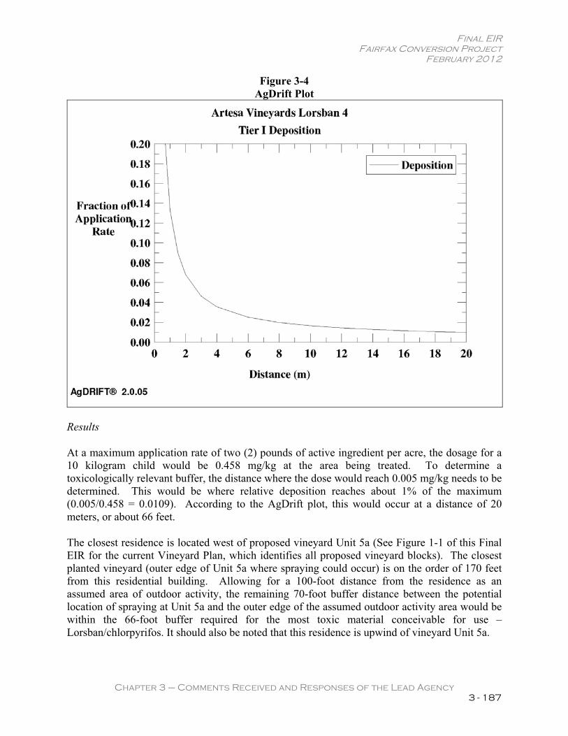
Final EIR Fairfax Conversion Project
February 2012
Chapter 3 – Comments Received and Responses of the Lead Agency 3 - 187
Figure 3-4 AgDrift Plot
Results
At a maximum application rate of two (2) pounds of active ingredient per acre, the dosage for a 10 kilogram child would be 0.458 mg/kg at the area being treated. To determine a toxicologically relevant buffer, the distance where the dose would reach 0.005 mg/kg needs to be determined. This would be where relative deposition reaches about 1% of the maximum (0.005/0.458 = 0.0109). According to the AgDrift plot, this would occur at a distance of 20 meters, or about 66 feet.
The closest residence is located west of proposed vineyard Unit 5a (See Figure 1-1 of this Final EIR for the current Vineyard Plan, which identifies all proposed vineyard blocks). The closest planted vineyard (outer edge of Unit 5a where spraying could occur) is on the order of 170 feet from this residential building. Allowing for a 100-foot distance from the residence as an assumed area of outdoor activity, the remaining 70-foot buffer distance between the potential location of spraying at Unit 5a and the outer edge of the assumed outdoor activity area would be within the 66-foot buffer required for the most toxic material conceivable for use – Lorsban/chlorpyrifos. It should also be noted that this residence is upwind of vineyard Unit 5a.
Final EIR Fairfax Conversion Project
February 2012
Chapter 3 – Comments Received and Responses of the Lead Agency 3 - 188
There are also two residential structures on the Wellman property near proposed vineyard Unit 1b. The closest residence would be approximately 260 feet from the outer edge of the planted vineyard and the second residence would be approximately 415 feet from the outer edge of the planted vineyard. Allowing for a 100-foot distance from the buildings as an assumed area of outdoor activity, the buffer distances would be 160 and 315 feet, respectively. This would be substantially greater than the 66-foot buffer distance calculated for the most toxic material conceivable for use. It should also be noted that the two residential structures on the Wellman property are approximately 30 feet higher than, and upwind (prevailing westerly winds) of vineyard Unit 1b.
In summary, a very conservative determination of a toxicologically relevant buffer distance was calculated using the AgDrift model and assuming use of the most toxic material conceivable for use in the proposed vineyards. Based on this analysis, the proposed vineyard provides adequate and appropriate buffer distances between the vineyard blocks and neighboring residences. In addition, as noted on page 3.8-22 of the DEIR (see above excerpt of this section of the DEIR), air movement is the most important environmental factor influencing the drift of pesticides from target areas. Pesticide applications will not be made when winds exceed 5 miles per hour. Windy conditions occur when the temperature near the ground increases, causing hot air to rise faster and mix rapidly with the cooler air above it. These conditions favor drift and may occur during midday when the wind speed often increases. As such, pesticide applications will be made in the early morning and/or early evening. Under most circumstances, except in the case of temperature inversions, these are the best times to apply pesticides because the spray droplets will move slowly upward. Wind speed will be monitored at the site of application, rather than at the local weather station or the vineyard headquarters.
Pesticide applications will not be made under conditions of low relative humidity and/or high temperatures, as they increase the potential for spray drift. Under these conditions, the evaporation rate of water increases, resulting in smaller spray droplets that drift more easily.
Pesticide applications will not be made in the presence of temperature inversions. The presence of strong temperature inversions increases the risk of drift. These stable air conditions (inversions) shall be determined by placing thermometers at ground level and 8 feet above the ground. Temperatures will be compared for the differences. If the temperature at ground level is below that found at the elevated thermometer, a temperature inversion exists and spraying shall not commence until such time the inversion has passed.
Aquatic Organisms
The UC Davis site provided by the commenter is a list of pesticides used in Sonoma County for the year 2000. There have been great strides in vineyard pest management over the last decade which are not reflected in that study. A more up to date listing can be found for 2007 at http://www.cdpr.ca.gov/docs/pur/pur07rep/comcnty/sonoma07_site.pdf.
Among the top chemicals cited by the commenter are Benomyl, which DuPont ceased production of in 2001 and is not a product the applicant (Artesa) would use in the proposed vineyard; in 2007, only 112 lbs. (22 applications) were used in Sonoma County. Mancozeb is a
Final EIR Fairfax Conversion Project
February 2012
Chapter 3 – Comments Received and Responses of the Lead Agency 3 - 189
carbamate fungicide that is used by an ever decreasing number of vineyards in Sonoma County, but now falls low on the list of chemicals. At the time of the writing of this Final EIR (August 2011), Artesa no longer uses this chemical. Therefore, it is necessary to clarify the current information contained in Table 3.8-2 of the DEIR, which lists dithane (mancozeb) as a potential agricultural chemical to be applied on-site. While dithane (mancozeb) was used much more frequently in the past in the industry, there are now many more fungicides that are at least as effective as dithane (mancozeb), but, importantly, pose a lower risk to receptors. The list of chemicals included in Table 3.8-2 of the DEIR is based upon the vineyard manager’s then-current review of the previous few years of limited chemical usage at all of Artesa’s vineyards. Given the fact that the DEIR was released in June 2009, the chemical inventory review performed by the vineyard manager during preparation of the DEIR now reflects the chemicals used by Artesa 3-5 years ago. The agricultural chemistry has improved considerably over the last 3-5 years. While Artesa has used dithane (mancozeb) in the past in rare circumstances, this chemical is no longer being used, as there are now many options, which are better than dithane (mancozeb) from an environmental perspective.18 As a result, Table 3.8-2 of the DEIR, Agricultural Chemicals to Potentially be Applied Onsite, is hereby revised below to remove dithane (mancozeb) from the list of potential chemicals. Furthermore, Table 3.8-2 is revised below to remove the fungicide Abound as Artesa no longer uses this chemical due to concerns that target organisms have developed a resistance; and while Nexter is still in use in the greater industry, it is hereby removed from Table 3.8-2 due to new, lower impact alternatives being used by Artesa as of late. Similarly, Pristine and Applaud have been added to Table 3.8-2 given that these chemicals are lower impact alternatives (compared to those hereby deleted from the table) that more accurately represent what is being used today by both Artesa and the greater industry.
Intrepid is also hereby added to Table 3.8-2 out of an abundance of caution to address the limited potential for crop damage by the light brown apple moth and European grapevine moth, both of which are new pests since the initial preparation of Table 3.8-2 of the DEIR.
Lastly, as a result of public comment and further consideration by the vineyard manager and project applicant, the decision has been made not to utilize POEA surfactants; rather, only surfactants approved for use near water, such as Latron. Therefore, CMR Silicone Surfactant is hereby deleted from Table 3.8-2 below.
18 Personal communication between Raney Division Manager, Nick Pappani, and Dr. Don Clark, Artesa Vineyard Manager, May 27, 2010.
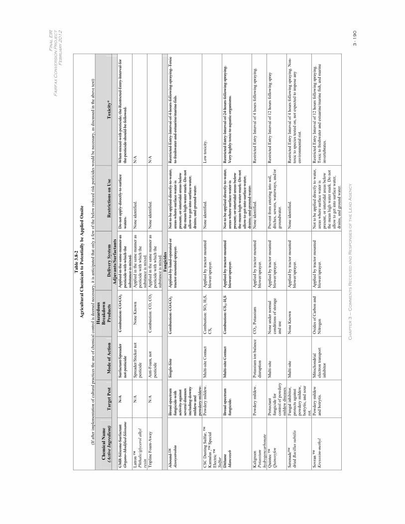
Fin
al
EIR
F
air
fax
Co
nv
er
sio
n P
ro
jec
t F
eb
ru
ar
y 2
01
2
Ch
ap
ter
3 –
Co
mm
en
ts R
ec
eiv
ed
an
d R
es
po
ns
es
of
th
e L
ea
d A
ge
nc
y 3
- 1
90
Tab
le 3
.8-2
A
gric
ultu
ral C
hem
ical
s to
Pote
ntia
lly b
e A
pplie
d O
nsite
(If a
fter i
mpl
emen
tatio
n of
cul
tura
l pra
ctic
es th
e us
e of
che
mic
al c
ontro
l is d
eem
ed n
eces
sary
, it i
s ant
icip
ated
that
onl
y a
few
of t
he b
elow
redu
ced
risk
pest
icid
es w
ould
be
nece
ssar
y, a
s dis
cuss
ed in
the
abov
e te
xt)
Che
mic
al N
ame
(Act
ive
Ingr
edie
nt)
Tar
get P
est
Mod
e of
Act
ion
Haz
ardo
us
Bre
akdo
wn
Prod
ucts
Del
iver
y Sy
stem
R
estr
ictio
ns o
n U
se
Tox
icity
* A
djuv
ants
/Sur
fact
ants
CM
R S
ilico
ne S
urfa
ctan
t
Org
ano-
Mod
ified
Silo
xane
N/A
Su
rfac
tant
/Spr
eade
rno
t pes
ticid
eC
ombu
stio
n: C
O/C
O2
App
lied
in th
e sa
me
man
ner a
s pe
stic
ide
with
whi
ch th
e su
bsta
nce
is m
ixed
.
Do
not a
pply
dire
ctly
to su
rfac
e w
ater
s. W
hen
mix
ed w
ith p
estic
ide,
the
Res
trict
ed E
ntry
Inte
rval
for
the
pest
icid
e sh
ould
be
follo
wed
.
Latro
n ™
Ph
thal
ic/g
lyce
rol a
lkyl
re
sin
N/A
Sp
read
er/S
ticke
r not
pe
stic
ide
Non
e K
now
n A
pplie
d in
the
sam
e m
anne
r as
pest
icid
e w
ith w
hich
the
subs
tanc
e is
mix
ed.
Non
e id
entif
ied.
N
/A
Trip
line
Foam
-Aw
ay
N/A
A
nti-F
oam
, not
pe
stic
ide
Com
bust
ion:
CO
, CO
2 A
pplie
d in
the
sam
e m
anne
r as
pest
icid
e w
ith w
hich
the
subs
tanc
e is
mix
ed.
Non
e id
entif
ied.
N
/A
Fung
icid
es
Abo
und
™
Azox
ystro
bin
Bro
ad sp
ectru
m
fung
icid
e w
ith
activ
ity a
gain
st
seve
ral d
isea
ses
incl
udin
g do
wny
m
ildew
and
po
wde
ry m
ildew
.
Sing
le-S
ite
Com
bust
ion:
CO
/CO
2A
pplie
d by
han
d-op
erat
ed o
r tra
ctor
mou
nted
spra
yer.
Not
to b
e ap
plie
d di
rect
ly to
wat
er,
area
s whe
re su
rfac
e w
ater
is
pres
ent,
or in
terti
dal a
reas
bel
ow
the
mea
n hi
gh w
ater
mar
k. D
o no
t al
low
to g
et in
to su
rfac
e w
ater
, dr
ains
, and
gro
und
wat
er.
Res
trict
ed E
ntry
Inte
rval
of 4
hou
rs fo
llow
ing
spra
ying
. Tox
ic
to fr
eshw
ater
and
est
uarin
e/m
arin
e fis
h.
CSC
Dus
ting
Sulfu
r, ™
K
umul
us ,™
Spe
cial
El
ectri
c ™
Su
lfur
Pow
dery
mild
ew.
Mul
ti-si
te C
onta
ct
Com
bust
ion:
SO
2,H
2S,
CS s
App
lied
by tr
acto
r mou
nted
bl
ower
/spr
ayer
. N
one
iden
tifie
d.
Low
toxi
city
.
Dith
ane
M
anco
zeb
Bro
ad sp
ectru
m
fung
icid
e.
Mul
ti-si
te C
onta
ct
Com
bust
ion:
CS 2
, HsS
App
lied
by tr
acto
r mou
nted
bl
ower
/spr
ayer
. N
ot to
be
appl
ied
dire
ctly
to w
ater
, ar
eas w
here
surf
ace
wat
er is
pr
esen
t, or
inte
rtida
l are
as b
elow
th
e m
ean
high
wat
er m
ark.
Do
not
allo
w to
get
into
surf
ace
wat
er,
drai
ns, a
nd g
roun
d w
ater
.
Res
trict
ed E
ntry
Inte
rval
of 2
4 ho
urs f
ollo
win
g sp
rayi
ng.
Ver
y hi
ghly
toxi
c to
aqu
atic
org
anis
ms.
Kal
igre
en
Pota
ssiu
m
hydr
ogen
carb
onat
e
Pow
dery
mild
ew.
Pota
ssiu
m io
n ba
lanc
e di
srup
tion
CO
2, Po
tass
ium
A
pplie
d by
trac
tor m
ount
ed
blow
er/s
pray
er.
Non
e id
entif
ied.
R
estri
cted
Ent
ry In
terv
al o
f 4 h
ours
follo
win
g sp
rayi
ng.
Qui
ntec
™
Qui
noxy
fen
Prot
ecta
nt
fung
icid
e fo
r co
ntro
l of p
owde
ry
mild
ew d
isea
ses.
Mul
ti-si
te
Non
e un
der n
orm
al
cond
ition
s of s
tora
ge
and
use
App
lied
by tr
acto
r mou
nted
bl
ower
/spr
ayer
. Pr
even
t fro
m e
nter
ing
into
soil,
di
tche
s, se
wer
s, w
ater
way
s, an
d/or
gr
ound
wat
er.
Res
trict
ed E
ntry
Inte
rval
of 1
2 ho
urs f
ollo
win
g sp
ray
Sere
nade
™
drie
d Ba
cillu
s sub
tilis
Fung
al in
hibi
tor,
prot
ects
aga
inst
po
wde
ry m
ildew
, bo
trytis
, and
sour
ro
t.
Mul
ti-si
te
Non
e K
now
n A
pplie
d by
trac
tor m
ount
ed
blow
er/s
pray
er.
Non
e id
entif
ied.
R
estri
cted
Ent
ry In
terv
al o
f 4 h
ours
follo
win
g sp
rayi
ng. N
on-
toxi
c to
spec
ies t
este
d on
, not
exp
ecte
d to
impo
se a
ny
envi
ronm
enta
l ris
t.
Sovr
an ™
Kre
soxi
m-m
ethy
lPo
wde
ry m
ildew
an
d bo
trytis
. M
itoch
ondr
ial
elec
tron
trans
port
inhi
bito
r
Oxi
des o
f Car
bon
and
Nitr
ogen
A
pplie
d by
trac
tor m
ount
ed
blow
er/s
pray
er.
Not
to b
e ap
plie
d di
rect
ly to
wat
er,
area
s whe
re su
rfac
e w
ater
is
pres
ent,
or in
terti
dal a
reas
bel
ow
the
mea
n hi
gh w
ater
mar
k. D
o no
t al
low
to g
et in
to su
rfac
e w
ater
, dr
ains
, and
gro
und
wat
er.
Res
trict
ed E
ntry
Inte
rval
of 1
2 ho
urs f
ollo
win
g sp
rayi
ng.
Toxi
c to
fres
hwat
er a
nd e
stua
rine/
mar
ine
fish,
and
mar
ine
inve
rtebr
ates
.
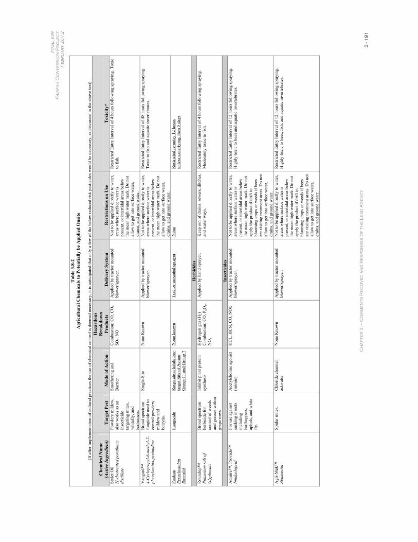
Fin
al
EIR
F
air
fax
Co
nv
er
sio
n P
ro
jec
t F
eb
ru
ar
y 2
01
2
Ch
ap
ter
3 –
Co
mm
en
ts R
ec
eiv
ed
an
d R
es
po
ns
es
of
th
e L
ea
d A
ge
nc
y 3
- 1
91
Tab
le 3
.8-2
A
gric
ultu
ral C
hem
ical
s to
Pote
ntia
lly b
e A
pplie
d O
nsite
(If a
fter i
mpl
emen
tatio
n of
cul
tura
l pra
ctic
es th
e us
e of
che
mic
al c
ontro
l is d
eem
ed n
eces
sary
, it i
s ant
icip
ated
that
onl
y a
few
of t
he b
elow
redu
ced
risk
pest
icid
es w
ould
be
nece
ssar
y, a
s dis
cuss
ed in
the
abov
e te
xt)
Che
mic
al N
ame
(Act
ive
Ingr
edie
nt)
Tar
get P
est
Mod
e of
Act
ion
Haz
ardo
us
Bre
akdo
wn
Prod
ucts
Del
iver
y Sy
stem
R
estr
ictio
ns o
n U
se
Tox
icity
* St
ylet
Oil
Hyd
rotr
eate
d pa
rafin
nic
dist
illat
e
Pow
dery
mild
ew,
also
wor
ks a
s an
inse
ctic
ide
targ
etin
g m
ites,
whi
tefly
, and
le
afm
iner
s.
Smot
herin
g an
d B
arrie
r C
ombu
stio
n: C
O, C
O2,
SO2,
NO
App
lied
by tr
acto
r mou
nted
bl
ower
/spr
ayer
. N
ot to
be
appl
ied
dire
ctly
to w
ater
, ar
eas w
here
surf
ace
wat
er is
pr
esen
t, or
inte
rtida
l are
as b
elow
th
e m
ean
high
wat
er m
ark.
Do
not
allo
w to
get
into
surf
ace
wat
er,
drai
ns, a
nd g
roun
d w
ater
.
Res
trict
ed E
ntry
Inte
rval
of 4
hou
rs fo
llow
ing
spra
ying
. Tox
ic
to fi
sh.
Van
gard
™
4-C
yclo
prop
yl-6
-met
hyl-2
-ph
enyl
amin
o-py
rim
idin
e
Bro
ad sp
ectru
m
fung
icid
e us
ed to
co
ntro
l pow
dery
m
ildew
and
bo
trytis
.
Sing
le-S
ite
Non
e K
now
n A
pplie
d by
trac
tor m
ount
ed
blow
er/s
pray
er.
Not
to b
e ap
plie
d di
rect
ly to
wat
er,
area
s whe
re su
rfac
e w
ater
is
pres
ent,
or in
terti
dal a
reas
bel
ow
the
mea
n hi
gh w
ater
mar
k. D
o no
t al
low
to g
et in
to su
rfac
e w
ater
, dr
ains
, and
gro
und
wat
er.
Res
trict
ed E
ntry
Inte
rval
of 4
8 ho
urs f
ollo
win
g sp
rayi
ng.
Toxi
c to
fish
and
aqu
atic
inve
rtebr
ates
.
Pris
tine
Pyra
clos
tobi
n
Bosc
alid
Fung
icid
e R
espi
ratio
n In
hibi
tors
-ta
rget
Site
of A
ctio
n G
roup
11
and
Gro
up 7
Non
e kn
own
Trac
tor-
mou
nted
spra
yer
Non
e R
estri
cted
re-e
ntry
12
hour
s un
less
can
e-ty
ing,
then
5 d
ays
Her
bici
des
Rou
ndup
™
Pota
ssiu
m sa
lt of
G
lyph
osat
e
Bro
ad sp
ectru
m
herb
icid
e fo
r co
ntro
l of w
eeds
an
d gr
asse
s with
in
grap
e ro
ws.
Inhi
bit p
lant
pro
tein
sy
nthe
sis
Hyd
roge
n ga
s (H
2)C
ombu
stio
n: C
O, P
xOy,
NO
x
App
lied
by h
and
spra
yer.
Kee
p ou
t of d
rain
s, se
wer
s, di
tche
s, an
d w
ater
way
s. R
estri
cted
Ent
ry In
terv
al o
f 4 h
ours
follo
win
g sp
rayi
ng.
Mod
erat
ely
toxi
c to
fish
.
Inse
ctic
ides
A
dmire
™, P
rova
do™
Im
idac
lopr
idFo
r use
aga
inst
su
ckin
g in
sect
s in
clud
ing
leaf
hopp
ers,
aphi
ds, a
nd w
hite
fly
.
Ace
tylc
holin
e ag
onis
t (m
imic
) H
CL,
HC
N, C
O, N
Ox
App
lied
by tr
acto
r mou
nted
bl
ower
/spr
ayer
. N
ot to
be
appl
ied
dire
ctly
to w
ater
, ar
eas w
here
surf
ace
wat
er is
pr
esen
t, or
inte
rtida
l are
as b
elow
th
e m
ean
high
wat
er m
ark.
Do
not
appl
y th
e pr
oduc
t if d
rift t
o bl
oom
ing
crop
s or w
eeds
if b
ees
are
visi
ting
treat
men
t are
as. D
o no
t al
low
to g
et in
to su
rfac
e w
ater
, dr
ains
, and
gro
und
wat
er.
Res
trict
ed E
ntry
Inte
rval
of 1
2 ho
urs f
ollo
win
g sp
rayi
ng.
Hig
hly
toxi
c to
bee
s and
aqu
atic
inve
rtebr
ates
.
Agr
i-Mek
™
Abam
ectin
Spid
er m
ites.
Chl
orid
e ch
anne
l ac
tivat
orN
one
Kno
wn
App
lied
by tr
acto
r mou
nted
bl
ower
/spr
ayer
. N
ot to
be
appl
ied
dire
ctly
to w
ater
, ar
eas w
here
surf
ace
wat
er is
pr
esen
t, or
inte
rtida
l are
as b
elow
th
e m
ean
high
wat
er m
ark.
Do
not
appl
y th
e pr
oduc
t if d
rift t
o bl
oom
ing
crop
s or w
eeds
if b
ees
are
visi
ting
treat
men
t are
as. D
o no
t al
low
to g
et in
to su
rfac
e w
ater
, dr
ains
, and
gro
und
wat
er.
Res
trict
ed E
ntry
Inte
rval
of 1
2 ho
urs f
ollo
win
g sp
rayi
ng.
Hig
hly
toxi
c to
bee
s, fis
h, a
nd a
quat
ic in
verte
brat
es.
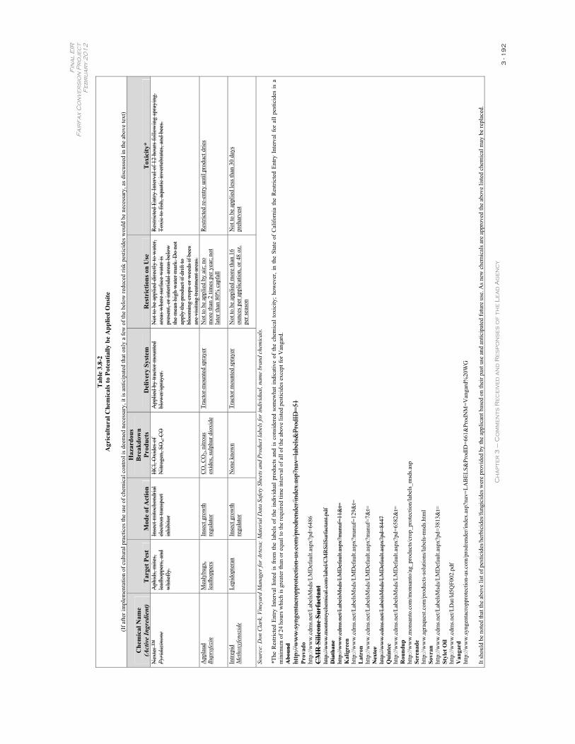
Fin
al
EIR
F
air
fax
Co
nv
er
sio
n P
ro
jec
t F
eb
ru
ar
y 2
01
2
Ch
ap
ter
3 –
Co
mm
en
ts R
ec
eiv
ed
an
d R
es
po
ns
es
of
th
e L
ea
d A
ge
nc
y 3
- 1
92
Tab
le 3
.8-2
A
gric
ultu
ral C
hem
ical
s to
Pote
ntia
lly b
e A
pplie
d O
nsite
(If a
fter i
mpl
emen
tatio
n of
cul
tura
l pra
ctic
es th
e us
e of
che
mic
al c
ontro
l is d
eem
ed n
eces
sary
, it i
s ant
icip
ated
that
onl
y a
few
of t
he b
elow
redu
ced
risk
pest
icid
es w
ould
be
nece
ssar
y, a
s dis
cuss
ed in
the
abov
e te
xt)
Che
mic
al N
ame
(Act
ive
Ingr
edie
nt)
Tar
get P
est
Mod
e of
Act
ion
Haz
ardo
us
Bre
akdo
wn
Prod
ucts
Del
iver
y Sy
stem
R
estr
ictio
ns o
n U
se
Tox
icity
* N
exte
r ™
Py
rida
zino
ne
Aph
ids,
mite
s, le
afho
pper
s, an
d w
hite
fly.
Inse
ct m
itoch
ondr
ial
elec
tron
trans
port
inhi
bito
r
HC
l, O
xide
s of
Nitr
ogen
, SO
x, C
O
App
lied
by tr
acto
r mou
nted
bl
ower
/spr
ayer
. N
ot to
be
appl
ied
dire
ctly
to w
ater
, ar
eas w
here
surf
ace
wat
er is
pr
esen
t, or
inte
rtida
l are
as b
elow
th
e m
ean
high
wat
er m
ark.
Do
not
appl
y th
e pr
oduc
t if d
rift t
o bl
oom
ing
crop
s or w
eeds
if b
ees
are
visi
ting
treat
men
t are
as.
Res
trict
ed E
ntry
Inte
rval
of 1
2 ho
urs f
ollo
win
g sp
rayi
ng.
Toxi
c to
fish
, aqu
atic
inve
rtebr
ates
, and
bee
s.
App
laud
Bu
prof
ezin
M
ealy
bugs
, le
afho
pper
s In
sect
gro
wth
re
gula
tor
CO
, CO
2, ni
trous
ox
ides
, sul
phur
dio
xide
Tr
acto
r-m
ount
ed sp
raye
r N
ot to
be
appl
ied
by a
ir; n
o m
ore
than
2 ti
mes
per
yea
r; no
t la
ter t
han
80%
cap
fall
Res
trict
ed re
-ent
ry u
ntil
prod
uct d
ries
Intre
pid
Met
hoxy
feno
zide
Lepi
dopt
eran
In
sect
gro
wth
re
gula
tor
Non
e kn
own
Trac
tor m
ount
ed sp
raye
r N
ot to
be
appl
ied
mor
e th
an 1
6 ou
nces
per
app
licat
ion,
or 4
8 oz
. pe
r sea
son
Not
to b
e ap
plie
d le
ss th
an 3
0 da
ys
preh
arve
st
Sour
ce: D
on C
lark
, Vin
eyar
d M
anag
er fo
r Art
esa;
Mat
eria
l Dat
a Sa
fety
She
ets a
nd P
rodu
ct la
bels
for i
ndiv
idua
l, na
me
bran
d ch
emic
als.
*The
Res
trict
ed E
ntry
Int
erva
l lis
ted
is f
rom
the
labe
ls o
f th
e in
divi
dual
pro
duct
s an
d is
con
side
red
som
ewha
t ind
icat
ive
of th
e ch
emic
al to
xici
ty; h
owev
er, i
n th
e St
ate
of C
alifo
rnia
the
Res
trict
ed E
ntry
Int
erva
l for
all
pest
icid
es is
a
min
imum
of 2
4 ho
urs w
hich
is g
reat
er th
an o
r equ
al to
the
requ
ired
time
inte
rval
of a
ll of
the
abov
e lis
ted
pest
icid
es e
xcep
t for
Van
gard
. A
boun
d ht
tp://
ww
w.sy
ngen
tacr
oppr
otec
tion-
us.c
om/p
rodr
ende
r/ind
ex.a
sp?n
av=l
abel
s&Pr
odID
=51
Prov
ado
http
://w
ww
.cdm
s.net
/Lab
elsM
sds/
LMD
efau
lt.as
px?p
d=64
86
CM
R S
ilico
ne S
urfa
ctan
t
http
://w
ww
.mon
tere
yche
mic
al.c
om/la
bel/C
MR
SilS
urfa
ctan
t.pdf
D
iath
ane
http
://w
ww
.cdm
s.net
/Lab
elsM
sds/
LMD
efau
lt.as
px?m
anuf
=11&
t=
Kal
igre
enht
tp://
ww
w.c
dms.n
et/L
abel
sMsd
s/LM
Def
ault.
aspx
?man
uf=1
29&
t=
Lat
ron
http
://w
ww
.cdm
s.net
/Lab
elsM
sds/
LMD
efau
lt.as
px?m
anuf
=7&
t=
Nex
ter
http
://w
ww
.cdm
s.net
/Lab
elsM
sds/
LMD
efau
lt.as
px?p
d=84
47
Qui
ntec
ht
tp://
ww
w.c
dms.n
et/L
abel
sMsd
s/LM
Def
ault.
aspx
?pd=
6582
&t=
R
ound
up
http
://w
ww
.mon
sant
o.co
m/m
onsa
nto/
ag_p
rodu
cts/
crop
_pro
tect
ion/
labe
ls_m
sds.a
sp
Sere
nade
ht
tp://
ww
w.a
graq
uest
.com
/pro
duct
s-so
lutio
ns/la
bels
-msd
s.htm
lSo
vran
ht
tp://
ww
w.c
dms.n
et/L
abel
sMsd
s/LM
Def
ault.
aspx
?pd=
3813
&t=
St
ylet
Oil
http
://w
ww
.cdm
s.net
/LD
at/ld
5QF0
02.p
df
Van
gard
ht
tp://
ww
w.sy
ngen
tacr
oppr
otec
tion-
us.c
om/p
rodr
ende
r/ind
ex.a
sp?n
av=L
AB
ELS&
Prod
ID=6
61&
Prod
NM
=Van
gard
%20
WG
It sh
ould
be
note
d th
at th
e ab
ove
list o
f pes
ticid
es/h
erbi
cide
s/fu
ngic
ides
wer
e pr
ovid
ed b
y th
e ap
plic
ant b
ased
on
thei
r pas
t use
and
ant
icip
ated
futu
re u
se. A
s new
che
mic
als a
re a
ppro
ved
the
abov
e lis
ted
chem
ical
may
be
repl
aced
.
Final EIR Fairfax Conversion Project
February 2012
Chapter 3 – Comments Received and Responses of the Lead Agency 3 - 193
Two of the other products listed by the commenter, 1,3, dichloropropene and methyl bromide, are soil fumigants. The use of both these chemicals is rare in vineyards (see the 2007 report), and is not a program that Artesa has any intention of undertaking. As stated on page 3.8-25 of the DEIR:
The IPM Plan for the proposed project is listed in Table 3.8-3, below. The applicant has indicated that instead of using methyl bromide fumigation on the site’s soil prior to vineyard development, resistant rootstock would be utilized by vineyard managers in order to reduce the chance of damage from agents such as grape phylloxera (Daktulosphaira vitifoliae), a small, soil-dwelling aphid-like insect which damages vine roots by feeding on them. The UC Pest Management Guidelines indicates that the use of resistant rootstock is the only completely effective means of phylloxera control; pesticide use is not an effective means of eradicating phylloxera. Other pest management methods that may be used on the project site could include habitat control (deer fencing around individual vineyard blocks and bird netting on vineyard rows), beneficial predator inducement (nest boxes for raptors), and predator enhancement via importation (importation of beneficial insects or bacteria).
Other chemicals listed by the commenter include pre-emergent herbicides, which Artesa also does not use in any of its existing vineyards and similarly does not plan to use in the subject vineyard. Artesa only uses contact herbicides that minimize, if not eliminate, the chance of off-site impacts. Table 3.8-2 of the DEIR, as revised in this Final EIR, lists agricultural chemicals that the applicant would use in the event of a pest outbreak, and CAL FIRE believes that this list is more germane to the analysis of the potential effects of this project as compared to the UC Davis list of what other vineyards in Sonoma County were using in 2000, or for that matter, what other vineyards are using today. Table 3.8-2 of the DEIR does not quantify the amounts of pesticides to be used because they would only be applied in the event of a pest outbreak, at which time the applicant would use the appropriate chemical using quantities in strict accordance with the label instructions and any applicable usage guidelines. The applicant will not use any agricultural chemical that is not legally sanctioned for use, nor will such use violate any rule or regulation.
The use of such legally sanctioned and regulated agricultural chemicals would not have an effect on downstream aquatic organisms that can be substantiated or quantified as a direct specific effect of their application in the proposed vineyards. While the commenter’s concerns are understandable and hereby noted, the requested analysis would be speculative at best. Scientists have not demonstrated that the proposed chemicals to be used would have a significant effect on the environment when used in accordance with label instructions. It would take many years of study to develop an assessment of such impacts, and the proposed vineyard would have to be in operation so that studies could be directly related to the vineyard. CEQA requires use of current information, and at this point in time, there is no evidence that the proposed limited use of these chemicals in small and infrequent applications would have a significant effect on organisms downstream of the project site.
Further, as stated in section 3.8-4 of the DEIR, to ensure that impacts to downstream aquatic life are minimal to none, the applicant’s vineyard management program draws on the best scientific information available regarding land management and pest control methods. These methods include the use of the University of California’s Integrated Pest Management (IPM) program,
Final EIR Fairfax Conversion Project
February 2012
Chapter 3 – Comments Received and Responses of the Lead Agency 3 - 194
specifically designed to promote environmentally and economically sustainable grape production, as well as state-of-the-art best management practices (BMPs).
As noted on page 3.8-27 of the DEIR, in addition to the use of IPM, the Fairfax Conversion project will be enrolled in the Fish Friendly Farming Program. This certification program, which is run by the non-profit California Land Stewardship Institute, supports the development of environmentally friendly land management practices that meet the high environmental standards required to improve conditions for salmon and trout downstream. One of the primary goals of the Fish Friendly Farms program is to limit chemical use in order to reduce impacts on fish species. When the program is completed, the site will be certified through the National Marine Fisheries Service, California State Regional Water Control Board, and the County Agricultural Commissioner.19 The applicant will also be enrolled in the California Association of Winegrape Growers’ Sustainable Winegrowing Program, through which chemical use is reduced through the implementation of Beneficial Management Practices. Thus, CAL FIRE and the applicant are drawing on the knowledge of the local scientific, environmental and regulatory communities, and working cooperatively with them to ensure that the proposed project minimizes the use of agricultural chemicals and impacts to aquatic wildlife to the maximum extent practicable.
Protection of Aquatic Environments and Sensitive Plant Species
Loading, mixing, and rinsing operations would be conducted a minimum of 500 feet from the Horkelia Preserve, as well as ponds, streams, wetlands, wells and other aquatic environments. A minimum 25-foot buffer shall be maintained between the targeted spray area and aquatic environments and the Horkelia Preserve. All spraying will be conducted downwind from aquatic environments and the Horkelia Preserve. In fact, the existing and proposed (i.e., created wetlands) on-site aquatic features located closest to proposed vineyard blocks are those features nearest vineyard Unit 4 and 5a. The area between open water and proposed vines is over 0.6-
19 The Fish Friendly Program involves several steps. First, owners or managers of vineyards voluntarily enroll their property in the Fish Friendly Farming (FFF) program. Secondly, through a series of mandatory workshops, each farmer will work with the FFF program staff to complete a Farm Conservation Plan for their property. The Farm Conservation Plan inventories and evaluates natural resources and practices on the entire property, not just agricultural lands. This approach assures a comprehensive program to achieve environmental quality and improvement. Following the workshops, the FFF program provides professional one-on-one technical assistance to each landowner/manager to complete the Farm Conservation Plan. This allows for all sediment sources and stream and river riparian corridors and water sources to be evaluated by an ecologist or other scientist. Various projects such as creek restoration and revegetation, water supply facility retrofit, road repair, and erosion site repair are identified in the Plan as well as the documentation of environmentally friendly management practices such as the use of cover crops or no-till practices. As a result, each Farm Conservation Plan is completely unique to each site. Thirdly, when the Farm Conservation Plan is completed the site is certified through a third party review of the property and the Plan. The certification team is made up of the National Marine Fisheries Service, California State Regional Water Control Board, and the County Agricultural Commissioner. Subsequent to certification, the farmer takes steps to implement the actions and projects identified in the Farm Conservation Plan. Simple changes in management practices are given a shorter time frame for implementation, while larger projects such as restoration or road repair have longer time frames. CLSI continues to work with the owner to cost-share implementation of major projects. In addition, the farmer annually documents actions through photo-monitoring. After 5-7 years, a certified site goes through the process of re-certification, to ensure that the designated actions have been implemented and to update the Farm Conservation Plan if needed.
Final EIR Fairfax Conversion Project
February 2012
Chapter 3 – Comments Received and Responses of the Lead Agency 3 - 195
acre, with maximum, minimum, and average offsets between open water and vine rows of 107 feet, 33 feet, and 62 feet, respectively. Unit 5a is separated from the existing and proposed aquatic features by a driveway and two fences, with the distance between open water and vines being about 60-65 feet.
The vineyard plants are dormant generally from November through budbreak in April. Under dormancy, spraying operations would not be expected to occur in late fall or winter, with the exception of an herbicide spray in mid-winter (Dec/Jan) for early season weed control. This will be done with a Roundup-type product with no POEA surfactants. As is standard, safe and prudent practice, herbicides are never sprayed when there is a forecast of rain for 48 hours or more, or when there is standing water in the area to be sprayed. The product is directed at the low-growing vegetation near ground level from a height of approximately 12 inches above the ground, so the chances of drift are absolutely minimal. If deemed necessary, early season fungicides and a second herbicide spray would occur at early shoot growth (April-May). Most potential sprays are fungicides and occur from May-July, at which point in time most of the on-site aquatic features would be dry. Any other pesticide application would almost certainly be a spot treatment (not over the entire property) and only in response to an economically significant pest.
Response to Comment 7-10
Please see Response to Comment 7-9.
Response to Comment 7-11
Pond Turtle Patchett Creek was extensively surveyed for wildlife by Monk & Associates in the winter, spring and summer months between 2006 and 2007, well above and beyond the standards pursuant to CEQA and standards for detection of Pacific/northwest pond turtles. In addition, aquatic habitat surveys have continued in 2010. Pacific/northwest pond turtles have never been observed on the project site. At all times, Patchett Creek waters were clear and shallow enough to allow for easy identification of aquatic wildlife. Although Patchett Creek is considered perennial on the project site, the only perennial sections of the creek in the summer consist of a few small standing pools in the southern portion of the project site in heavily shaded forest habitat. The pools are too small to provide escape habitat for turtles and do not provide basking opportunities. Due to unsuitable habitat conditions and the extensive work completed in Patchett Creek by biologists over the years, and the lack of observed Pacific/northwest pond turtles, impacts to the amphibian species would not occur.
Due to an absence of suitable habitat, Pacific/northwest pond turtles are not expected to occur on the project site. The species requires perennial stream environments with deep pools to escape from predators, and sunny basking sites. These habitat requirements are not found in Patchett Creek within the project site.
Final EIR Fairfax Conversion Project
February 2012
Chapter 3 – Comments Received and Responses of the Lead Agency 3 - 196
Gualala Roach Gualala roach have been collected below the project site in the upper, middle, and lower Wheatfield Fork by CDFG (2001) as reported in the KRIS Gualala database. Gualala roach are relatively more abundant in the lower reaches of the watershed. The Fairfax Conversion project site does not provide suitable habitat for Gualala roach; and their ability to access the site is restricted by an impassable barrier to upstream migration located below the project site. See Response to Comment 12-10 for more discussion regarding Gualala roach.
Foothill Yellow-Legged Frog Foothill yellow-legged frog is adequately addressed in Impact 3.4-9 on page 3.4-138 of the DEIR. As stated on this page of the DEIR,
The foothill yellow-legged frog is a state species of special concern. It has no special federal status. Species of special concern must be addressed in CEQA documents. This frog has been identified in Patchett Creek onsite. It should be noted that most of Patchett Creek on the project site, and in all cases where foothill yellow-legged frogs have been found, is deeply incised in solid rock. Where the frogs occur the creek banks are vertical ranging between 6 and 8 feet in height. A broad channel bottom characterized by deep pools lies within the incised channel banks. Foothill yellow-legged frog survives on the project site in this protected aquatic system that is for all intents and purposes inaccessible to predators. Regardless, any impact to Patchett Creek from the proposed project could result in significant adverse impacts to the foothill yellow-legged frog. While no impacts are proposed to occur to Patchett Creek, at this time impacts to this frog are considered potentially significant. This impact could be reduced to a level considered less than significant pursuant to CEQA by implementation of the following mitigation measure.
Mitigation Measure(s) Implementation of the following mitigation measures would reduce the impact to a less-than-significant level.
3.4-9 In order to avoid impacting Patchett Creek and the foothill yellow-legged frogs that reside in this creek, a minimum 100-foot protective buffer will be maintained between Patchett Creek top-of-banks and project site development (Figure 3.4-4). This buffer will ensure that the existing shade and sunlight regimes present today in Patchett Creek are maintained except as modified by natural succession. In addition, a project site preconstruction SWPPP will be implemented prior to implementation of grading activities to ensure that Patchett Creek, and indeed most tributaries on the project site (with rare exception), are protected from siltation and/or other project-related downstream impacts. Similarly, a post-project BMPs plan will also be implemented to ensure that there are no impacts to the water quality in Patchett Creek or other downstream receiving waters after implementation of the project. In addition, there is no significant potential for contamination of Patchett Creek by the use of fertilizer, herbicide, insecticide, or other agricultural chemicals in the proposed vineyard. Qualified, properly certified vineyard managers will use only State-approved fertilizers, herbicides, insecticides or other agricultural chemicals in accordance with the label instructions and any applicable usage guidelines in the event that any of these are determined necessary. Implementation of the SWPPP and the post project BMPs plan, and the establishment of protective buffers along Patchett Creek will ensure that impacts to the foothill yellow-legged frog are avoided. These
Final EIR Fairfax Conversion Project
February 2012
Chapter 3 – Comments Received and Responses of the Lead Agency 3 - 197
measures are refined in Mitigation Measure(s) 3.7-2(a-h), 3.7-3(a and b) and 3.7-4.
Cumulative Impacts Related to Biological Resources and Hydrology Project erosion and hydrologic effects were analyzed in detail by the DEIR (See DEIR Section 3.7, Hydrology and Water Quality, for the project-level analysis, and Chapter 4, Cumulative Impacts, for the cumulative hydrology analysis; and DEIR Appendices M, N and O). Subsequently, these physical processes that could potentially contribute to cumulative watershed effects were evaluated by professional biologists (See DEIR Appendices I and J) to determine whether these processes would likely have significant effects on water quality and habitat in the downstream aquatic ecosystem. The results of these technical analyses are included in Section 3.4, Biological Resources, and Chapter 4, Cumulative Impacts, of the DEIR. As stated on page 4-22 of Chapter 4, Cumulative Impacts, of the DEIR, as revised in Chapter 2, Revisions to the DEIR Text, of this Final EIR, the proposed project is estimated to decrease sedimentation by 24 to 39 tons/yr.
The project’s long-term sediment contribution is projected to be less than existing levels. Specifically, as discussed in Chapter 3.7, Hydrology and Water Quality, upon implementation of the project sedimentation is estimated to decrease by 24 to 39 tons/yr. Other projects would also be required to implement BMPs; however, the efficacy of the measures implemented on other projects cannot be assured. Furthermore, additional sedimentation from construction is likely to occur. The effects of the proposed project, in combination with similar effects generated by other timber conversion and/or vineyard projects in the area, would be considered significant. However, as the proposed project would result in an estimated net decrease in sedimentation over time, the proposed project’s incremental contribution to the significant cumulative impact would not be cumulatively considerable. As a result, with the project’s BMPs and implementation of Mitigation Measures 3.7-2 (a-i) and 3.7-3 (a, b) required in the Hydrology and Water Quality chapter of the DEIR, the proposed project would have a less-than-significantcumulative impact.
The proposed project has been designed with state of the art Best Management Practices (BMPs) that will significantly control both project erosion and mobile sediment contribution to downstream environments. For example, project sedimentation basins as designed are predicted to reduce sediment yield by 50 percent, primarily by capturing sand and fine gravel greater than 0.1 mm diameter. Finer suspended sediment that passes through the sediment basins is relatively mobile in energetic stream systems such as Patchett Creek. Most of the sediment from the project site, following treatment in sedimentation basins, is expected to remain in the water column as the sediment is transported through Patchett Creek with relatively little deposition. As shown in Table 3.7-20 of the DEIR, the sedimentation basins (and the reservoir collection system) reduce the predicted increase in sediment yield of about 5 to 7 t/yr to a net decrease of about 8 to 13 t/yr. There is an estimated net decrease at the project area boundary draining to Patchett Creek of approximately 10 to 13 percent. Additional reductions in sediment yield by erosion mitigation designed to repair and control gully erosion at five sites in the project area is expected to reduce erosion rates by at least 16 t/yr (low range estimates) to 27 t/yr (high range estimates). These estimated sediment savings result in net decreases in sediment yield under project conditions of 24 to 39 t/yr.
Final EIR Fairfax Conversion Project
February 2012
Chapter 3 – Comments Received and Responses of the Lead Agency 3 - 198
The DEIR identifies specific mitigation measures to avoid and/or minimize impacts to water quality and quantity. For example, in addition to the requirement for all timber harvesting activities on the project site, including harvest-associated road construction and maintenance, to comply with California Forest Practice Rules water quality protection measures, as described in the Timber Harvest Plan prepared for the proposed project and approved by the Department of Forestry (cf. MM 3.7-2(a)), the DEIR requires the project applicant to implement a detailed Post-construction Monitoring Plan that is intended to supplement the project ECP and SWPPP for the first winter season after project construction (cf. MM 3.7-2(i)). This monitoring plan shall be implemented for areas where site preparation has occurred in the prior construction season, including soil preparation, grading and drainage installation. The first-year post-construction monitoring requirement is fulfilled if the monitoring period follows all grading and drainage work, regardless of whether vineyard planting and cover crops have been established. If site preparation work is conducted, but final grading and drainage installation is not complete, this monitoring plan will extend to the subsequent winter until final grading and drainage work is complete. In addition, per Mitigation Measure 3.7-3(b), the DEIR requires a detailed Channel Erosion and Sedimentation Basin Monitoring Plan to be implemented by the project applicant. As stated in Mitigation Measure 3.7-3(b), there is no substantial evidence that hydrologic change will cause significant erosion in Class III channels draining the project area. Channel response to peak flows is controlled by the size of channels, channel substrate, and the proximity of bedrock and boulder controlled channels downstream. Potential erosion of channels draining the project area is limited to varying degrees by these factors. Furthermore, peak discharge for high-magnitude, low-frequency flows (> 5 yr recurrence interval events) under current conditions indicate that the largest increases in peak flows (2 yr recurrence interval events) predicted under project conditions would be well within the range of flows transmitted by the existing channels in most locations. Hence, the potential for significant channel erosion related to peak flow change is limited by several factors.
Given the relatively high variability and complexity of hydrologic and geomorphic processes, channel response to identified potential peak flow increases is somewhat uncertain. While the predictable potential effects of the project with mitigation are not significant, unpredictable events or unexpected responses could have substantial impacts. Consequently, a monitoring program is presented in this mitigation measure. The objective of the monitoring plan is to observe and document erosion response, if any, of Class III channels draining the project area and verify that the magnitude of response does not rise to a significant level. No net increase in sediment yield from the project area is an environmental objective of the project. Central to the monitoring plan is the concept of adaptive management (See more discussion on this in the “Adaptive Management” section below). If monitoring data indicate that sediment yields from the project area are greater than predicted in the pre-project analyses, either from unexpected erosion of Class III channels or higher-than expected delivery rates of sediment eroded from vineyard fields, appropriate on- and off-site erosion mitigation will be developed with oversight by CAL FIRE or an alternative regulatory authority designated by CAL FIRE.
As noted above, the Erosion Analysis concluded that the project (with BMPs) is expected to reduce sediment yields by 24 to 39 t/yr. The specific objective of this monitoring plan is to determine whether potential increases in sediment yield associated with accelerated channel erosion are less than 24 to 39 t/yr. In addition, the performance of sedimentation basins will be
Final EIR Fairfax Conversion Project
February 2012
Chapter 3 – Comments Received and Responses of the Lead Agency 3 - 199
monitored to provide measurements of vineyard field erosion and sedimentation basin trapping efficiency. These measurements are warranted because they could lead to revisions of predicted vineyard field erosion, which could either increase or decrease the threshold of significance of channel erosion. The monitoring plan has three components:
1. Detailed topographic surveys of selected channels; 2. Annual survey of erosion of “sensitive” channels; and 3. Survey of selected sedimentation basins.
Topographic Surveys of Selected Class III Channel Reaches
This element of the monitoring plan would include detailed topographic surveys using a total survey station to measure changes in channel elevation for sample sections of selected Class III stream channels. This study approach has been previously implemented by O’Connor Environmental for Class III streams in Humboldt County to fulfill monitoring requirements of the Pacific Lumber Company Habitat Conservation Plan. The strength of this approach is that it develops accurate, objective quantitative data documenting the dimensions and elevation of channels before the project and three years after project completion. This will provide statistical measures (using parametric techniques), of channel erosion rates that can be extrapolated to assess the magnitude of channel erosion in the project area. The study will be designed so that a range of hydrologic change is observed that will indicate whether peak flow change is correlated with channel erosion rate. Specifically, six channels (2, 20, 31, 40, 45B and 60A; see Hydrologic Analysis, Figure 6, for locations of these channels, and Table 6 for the magnitude of expected peak flow change) would be monitored to determine erosion rates over a 3-year period.
Annual Surveys of Class III Channels
This annual survey would be conducted for the 18 channels considered to be moderately sensitive to peak flow (Hydrologic Analysis, Table 12). The survey technique to be employed would systematically observe and measure the surface area and depth of fresh channel and bank erosion features as a measure of annual erosion rates. This technique, while objective, requires field estimates that have only moderate levels of precision. The advantage of this approach is that it allows for broad coverage of the monitoring sites and is likely to detect significant changes in the rates of channel and bank erosion. Statistical tests for change would most likely utilize techniques for non-parametric data. These surveys would be conducted four times: once prior to project implementation to document baseline conditions, and then annually in late winter/early spring when annual erosion features are relatively easy to detect and measure. These annual surveys developed over a broad project area are also important in that they would likely detect unexpected rates of change in a time frame that would allow for timely response, if necessary.
Annual Surveys of Selected Sedimentation Basins
This annual survey would measure the volume of accumulated sediment and the grain size distribution of accumulated sediment in a sample of about 25% of the sedimentation basins in the project. By comparison to grain size distribution of the vineyard soils, the deposited sediment
Final EIR Fairfax Conversion Project
February 2012
Chapter 3 – Comments Received and Responses of the Lead Agency 3 - 200
size distribution and volume can be used to estimate the erosion rate of the vineyard fields and the sedimentation basin trapping efficiency (see Reid and Dunne, 1996, Rapid Evaluation of Sediment Budgets, p. 49). The monitoring would be comprised of annual measurements of depth of accumulated sediment in selected basins and collection and laboratory analysis of samples of accumulated sediment. The selection of basins for monitoring would include a range of sediment basin sizes. Data analysis would include comparison of pre-project estimates of vineyard erosion rates and sediment trapping efficiency to measured rates and efficiency.
Adaptive Management
If monitoring data indicate that sediment yields from the project area are greater than predicted in the pre-project analyses, either from unexpected erosion of Class III channels or higher-than expected delivery rates of sediment eroded from vineyard fields, additional on- and off-site erosion mitigation will be developed with oversight by CAL FIRE or an alternative regulatory authority designated by CAL FIRE to ensure compliance with the DEIR’s identified performance standards.
On- and off-site erosion mitigation, if deemed necessary and appropriate, may include identification of additional and presently unidentified erosion sites on the project site or on other property in the Patchett Creek watershed. Potential erosion sites could include road-related erosion sites, gullies, eroding stream banks, eroding landslide deposits, or other erosion sites delivering or potentially delivering substantial quantities of sediment to the stream channel network. Off-site projects should be developed in cooperation with any property owner involved, and should include an appropriate level of contribution from each property owner. Disused or informally abandoned logging roads and skid trails are probably the most appropriate type of erosion site to target for off-site mitigation, however, other types of sites should be considered if identified. If suitable or practical sites cannot be located in the Patchett Creek watershed, then sites in the Wheatfield Fork Gualala River watershed should be considered.
As planned, the proposed project would not create adverse environmental conditions downstream of the project site which would have a substantial impact on steelhead in lower Patchett Creek and/or Wheatfield Fork Gualala. Therefore, the potential project-related impacts to steelhead discussed above would be less-than-significant through project design and implementation of the rigorous erosion control measures included in Chapter 3.7 of the DEIR, as discussed in Impacts 3.4-11 through 3.4-14 of Chapter 3.4 of the DEIR, Biological Resources, and 4-5 and 4-8 of Chapter 4, Cumulative Impacts.
Response to Comment 7-12
Gualala roach have been collected below the project site in the upper, middle, and lower Wheatfield Fork by CDFG (2001) as reported in the KRIS Gualala database. Gualala roach are relatively more abundant in the lower reaches of the watershed. The Fairfax Conversion project site does not provide suitable habitat for Gualala roach; and their ability to access the site is restricted by an impassable barrier to upstream migration located below the project site. See Response to Comment 12-10 for more discussion regarding Gualala roach.
Final EIR Fairfax Conversion Project
February 2012
Chapter 3 – Comments Received and Responses of the Lead Agency 3 - 201
Response to Comment 7-13
Please see Response to Comment 7-11.
Response to Comment 7-14
Please see Response to Comment 7-9 for a response to herbicide application concerns, which states in part, as a result of public comment and further consideration by the vineyard manager and project applicant, the decision has been made not to utilize POEA surfactants; rather, only surfactants approved for use near water, such as Latron will be used. CMR Silicone Surfactant has been deleted from Table 3.8-2 above.
See Response to Comment 7-8 for a response to bullfrog concerns, which states in part, an impervious synthetic (16 millimeter HDPE) geotextile liner would be installed in the proposed vineyard reservoir on the project site. As with the existing reservoirs in the vicinity of the project site, the liner would prohibit the establishment of both emergent and shoreline riparian vegetation, thereby controlling the threat of establishment of bullfrogs.
Regarding the commenter’s concerns that groundwater could be exploited during critical drought years, as stated on page 2-24 of the DEIR, the proposed project annual irrigation demand during vine establishment would be approximately 53 acre-feet per year (See Appendix P to the DEIR, Vineyard Water Availability Evaluation, and the updated report included as Appendix K to this Final EIR). The proposed reservoir has been designed to hold approximately 73 acre-feet. In addition, once vines are established (typically three years after planting) dry-farming would be used to the extent feasible. That is, water from the proposed reservoir would not be applied to the vineyard for irrigation purposes under average climatic conditions. As stated on pages 3.7-81 through 3.7-86 of the DEIR, Impact 3.7-6, Project-related impacts to groundwater storage and recharge, the project would not utilize groundwater for irrigation purposes under any circumstances and could be expected to increase groundwater infiltration rates by reducing evapotranspiration (See Responses to Comments 7-15 and 12-5). Consistent with the conclusion in the DEIR, the proposed project impact to groundwater storage and recharge would be less-than-significant.
It should be noted that on the project site, Patchett Creek dries completely over most of the course length each summer. Over the last two years, Monk & Associates did not observe amphibians use in the perennial pools that hold water in the late summer or by mid-summer. The amphibians that are found seasonally in Patchett Creek are likely to migrate into lower watersheds in the mid-summer to find more reliable water sources that provide habitat conditions required to support these species. Similarly, fish did not occur and are not expected to occur in Patchett Creek on the project site. Under existing conditions, aquatic organisms that use Patchett Creek are adapted to a wet/dry cycle. Accordingly, a well draw-down from a small, low-yield well is not likely to affect Patchett Creek. The well draw-down would have little if any effects on wildlife that now seasonally use aquatic environments in Patchett Creek.
Final EIR Fairfax Conversion Project
February 2012
Chapter 3 – Comments Received and Responses of the Lead Agency 3 - 202
Response to Comment 7-15
As explained on page 2-24 of the Project Description Chapter of the DEIR, irrigation runoff would not occur with use of the drip system, and the Erosion Control Plan (ECP) notes that water losses due to reservoir seepage would be eliminated through the use of a synthetic liner. Annual evaporation losses are estimated at 40 inches in the ECP; however, because evaporative losses are factored into the reservoir design, viticultural demand can be met throughout the season under such conditions. The ECP calculated annual water demands using the following assumptions regarding the proposed vineyard: approximately 1,090 vines per acre would be planted based on an estimated 8-foot by 5-foot vine spacing. The row layouts would generally be at an angle relative to slopes, with regularly spaced, intermittent cross-slope drainage ditches provided in some blocks and sheet flow controls in other blocks. The project vineyard manager estimates that irrigation would be necessary every one to three weeks. According to data in the ECP and Vineyard Water Availability Evaluation (See Appendix P to the DEIR, and the updated report included as Appendix K to this Final EIR), total annual irrigation demand during the vine establishment phase would come to approximately 53 acre-feet per year (afy), resulting in residual storage volume at the end of the irrigation season. The proposed reservoir design is for 73 acre-foot (ac-ft) plus a two (2) ac-ft sump. Therefore, with the proposed reservoir having been conservatively designed to collect more water than needed for irrigation purposes, there is no need for the proposed domestic well to be used for irrigation purposes – accordingly, the project will not use well water for any irrigation purposes. See also Response to Comment 12-5.
Well water could theoretically be used to fill the proposed 73 ac-ft reservoir, but it would take 15 wells at 10 gpm and a 50% duty cycle operated over about eight months to provide the required volume (See Response to Comment 10-50). While sufficient groundwater could be available in the aquifer to support this level of withdrawal, the expense of developing and pumping this number of wells would be considerable. This water development approach is not feasible; it is not practical, cost-effective, or environmentally beneficial. Rather, a passive, low impact surface sheet flow runoff collection system has been designed for collection and storage of the required 73 acre feet of irrigation water in order to minimize project impacts.
Response to Comment 7-16
The commenter indicates that the DEIR attributes the vegetation on the property to historical activities. This attribution is reasonable considering the historical cultivation and logging activities that have occurred on the property.
The commenter goes on to indicate that the DEIR should have taken in to account the ‘legacy of aboriginal vegetation management’ associated with the property. While it is possible, even probable, that the inhabitants of the Native American sites in the Annapolis area practiced several forms of vegetation management, the current environment on the property cannot reasonably be attributed to Native American vegetation management.
Under Native American management practices, it would be unlikely that the conifers currently on the property would be present. More likely the area would have appeared as open grassland with scattered oaks. The practice of annual or bi-annual burning thwarted the growth of conifers,
Final EIR Fairfax Conversion Project
February 2012
Chapter 3 – Comments Received and Responses of the Lead Agency 3 - 203
allowing oaks, grasses, and root crops to grow without competition from conifer species (Anderson 2005:165-169;20 McCarthy 1993:22121).
The commenter also notes the presence of rhizome species that were economically important to Native American people. The simple presence of these plant species in the vicinity of an archaeological site does not make them culturally or historically important. No substantial evidence shows this to be a culturally significant gathering area, and none of the Native American people who consulted on this project, including the Tribal Historic Preservation Officer of the Kashia people, indicated that it was such an area.
For the landscape to be considered as a contributing element of an important archaeological site, the landscape would need to reflect the appearance of the area during the period the archaeological site was occupied. This would be an element of site integrity. The seven elements of integrity for historical resources are location, design, setting, materials, workmanship, feeling, and association (CCR Title 14 Chapter 11.5 4852 [c]). In this instance the integrity of location, design, and workmanship would be inapplicable; however the other four elements of integrity would still apply. The presence of extensive areas of conifers detracts from the integrity of setting. The presence of oaks and other economically important plants indicates some integrity of materials; however, the lack of an oak/grassland environment and areas where cultivation to enhance rhizome production are evident reflects very poor integrity of feeling and association. With only one of four applicable elements of integrity rating above poor, this landscape cannot convey its historical importance or association with the Native American site and should not be considered a significant element of the archaeological or cultural record.
Response to Comment 7-17
As stated in Mitigation Measure 3.4-2 on page 3.4-128 of the DEIR, fencing specifications for the proposed Annapolis manzanita preserves shall be “as recommended by CDFG, but at a minimum would include a metal post and wire fence that would allow wildlife access to the preserves.” The proposed fencing plan, which has been added to the Vineyard Plan, further indicates that deer exclusion fencing would be installed around individual vineyard units, and not used around the preserves.
In order to address the commenter’s concerns about forest succession on the proposed preserves, Mitigation Measures 3.4-1 and 3.4-2 are revised to require spot clearing of saplings within the preserve boundaries on a yearly basis. In addition, wildlife-friendly fencing shall be required on the horkelia preserve to ensure wildlife access. As such, Mitigation Measure 3.4-1 on page 3.4-127 of the DEIR is hereby revised as follows (See Responses to Comments 1-20, 1-21, and 1-23 for a detailed discussion of all of the below changes to DEIR Mitigation Measures 3.4-1 and 3.4-2):
20 K. Anderson, Tending the Wild: Native American Knowledge and the Management of California’s Natural Resources. University of California Press, 2005. 21 H. McCarthy, “Managing Oaks and Acorn Crops,” In Before the Wilderness: Environmental Management by Native Californians. (T. Blackburn and K. Anderson editors, Menlo Park: Ballena Press, 1993) 213-228.
Final EIR Fairfax Conversion Project
February 2012
Chapter 3 – Comments Received and Responses of the Lead Agency 3 - 204
3.4-1 Prior to the issuance of a grading permit, the applicant shall establish a 15.65-acre preserve on lands that has have been designated on the west side of the project site that will protect the largest population of thin-lobed horkelia from the proposed project impacts (Figure 3.4-4). This preserve will be dedicated in a permanent deed restriction recorded on the title of the property that shall run with the land in perpetuity. A wetland mitigation plan proposes the creation of wetlands in the thin-lobed horkelia preserve and in an Annapolis manzanita preserve (see below). Wetland creation will occur in portions of the preserve that do not currently support thin-lobed horkelia. Regardless, a very small number of these plants could be impacted within the preserve from implementation of a wetland mitigation compensation plan. This plan shall be subject to the review and approval of the CAL FIRE and the Sonoma County Permit and Resource Management Department.
The thin-lobed horkelia preserve shall be fenced according to the Fencing Plan prepared by Erickson Engineering. Wildlife-friendly fencing shall be installed along the northern and western perimeter of the preserve, with one gate at the northern road entrance. Wildlife-friendly fencing shall include a metal post and wire fence that would allow wildlife access to the preserve. No fencing will be necessary along the southern preserve boundary, as the preserve will be contiguous with a protected Streamside Conservation Area. Likewise, no fencing will be required along the eastern preserve boundary, as the adjoining forested lands are steep and undevelopable.
In addition, the vineyard has been designed to ensure that agricultural runoff does not enter the preserve. Following completion of vineyard development activities, the applicant shall ensure that any herbicide applications which may take place in the nearby vineyard unit(s) do not affect or enter the thin-lobed horkelia reserve.
The plan shall be subject to the review and approval of the Department of Forestry and the Sonoma County Permit and Resource Management Department.
Tree saplings shall be cleared on a yearly basis to prevent forest succession within the preserve. In addition, the vineyard has been designed to ensure that agricultural runoff does not enter the preserve. Following completion of vineyard development activities, the applicant shall ensure that any herbicide applications which may take place in the nearby vineyard unit(s) do not affect or enter the thin-lobed horkelia preserve.
Road access into the thin-lobed horkelia preserve shall be limited to vehicles for the purpose of wetland creation, preserve management,
Final EIR Fairfax Conversion Project
February 2012
Chapter 3 – Comments Received and Responses of the Lead Agency 3 - 205
maintenance, and scientific study. Timber harvest operations vehicles will use the new road that will be constructed north and west of the thin-lobed horkelia preserve to access the area south of the preserve as indicated on the revised Vineyard Plan dated May 24, 2010.
Weed-free mulch, native slash or clean straw shall be used for erosion control throughout the project site. All cover crops and erosion control seed mixes will use either native grasses derived from genetic stock from the region of the project site, or the sterile wheat/tall wheat hybrid, Regreen©. Within the horkelia preserve, erosion control shall be used on existing and temporary roads in areas where the potential exists for excessive sediment delivery to preserves and existing wetlands. All necessary erosion and sediment controls will be in place during activity associated with the construction of the access road west of the thin-lobed horkelia preserve.
In accordance with CDFG Guidelines for Conservation of Sensitive Plant Resources Within the Timber Harvest Review Process and During Timber Harvesting Operations 22, a five-year mitigation monitoring plan for the thin-lobed horkelia preserve shall be implemented as follows. The mitigation monitoring plan will ensure that timber operations are conducted consistent with the mitigation measures specified in the EIR.
To determine if the thin-lobed horkelia preserve is successfully supporting thin-lobed horkelia, the applicant shall have a qualified biologist conduct five years of plant monitoring. Annual spring sampling will be conducted when thin-lobed horkelia is in flower. Generally this species is in flower throughout its range between the months of May, June, and July. In 2009, thin-lobed horkelia was in full bloom in the proposed thin-lobed horkelia preserve in mid-June.
Monitoring shall include establishing fixed line sampling transects. In this fashion, trends in the plant communities can be ascertained. Sampling along fixed transects shall occur using a point intercept method derived from Bonham23 to demonstrate and quantify the extent of cover of the monitored species. The systematic point-intercept sampling method will be used to determine the frequency of plant species or group of plant species in the community.
Plant cover data for the monitored species shall be arrayed each year and compared. Because of normal stochastic fluctuations in all plant
22 CDFG 2005. Guidelines for Conservation of Sensitive Plant Resources Within the Timber Harvest Review Process and During Timber Harvesting Operations. Sacramento: California Department of Fish and Game, Habitat Conservation and Planning Branch. 9p. https://r1.dfg.ca.gov/portal/Portals/12/THPBotanicalGuidelinesJuly2005.pdf.
23 Bonham, C.D. 1989. Measurements For Terrestrial Vegetation. John Wiley & Sons. New York. 338 pp.
Final EIR Fairfax Conversion Project
February 2012
Chapter 3 – Comments Received and Responses of the Lead Agency 3 - 206
populations, only precipitous drops in cover of the monitored species shall be cause for further investigation. Plant cover data shall be arrayed over the five year monitoring period to determine population trends for the monitored plants. If the trend is significantly down, the annual monitoring report shall include an assessment of the possible reasons for population declines and recommendations for remedial actions that could reverse trends. Weather conditions such as drought and acts of God such as fire that cause precipitous population declines shall not constitute sufficient reason to take remedial actions. Any proposed remedial actions shall be discussed with CDFG in advance of the implementation of such measures.
At the end of each monitoring year, a monitoring report shall be submitted to the CDFG. At the end of the five-year monitoring period, CDFG shall be invited to examine the plant preserves to further go over conclusions presented in the final five-year monitoring report. At the end of the five-year monitoring period, provided the preserve is supporting a stable thin-lobed horkelia population, all monitoring requirements shall terminate.
3.4-2 Prior to issuance of a grading permit, the applicant shall set aside an area totaling approximately 4.4 acres on the east side of the project site (see Figure 3.4-4) for the preservation of Annapolis manzanita identified on the Artesa property. The preserve shall be dedicated in perpetuity through a permanent deed restriction recorded on the title of the property. The preserve area shall not be developed. Timber operations in the areas adjacent to the preserve shall use directional falling so that timber marked for removal falls away from the reserve area. Heavy equipment and vehicles shall be excluded from the preserve area during project development and operations.
The manzanitas within these preserves will be protected by fencing that will be maintained by the owner also in perpetuity. The preserve shall be fenced according to the Fencing Plan prepared by Erickson Engineering. Wildlife-friendly fencing shall include a metal post and wire fence that would allow wildlife access to the preserve. The preserve will be protected by vineyard fencing where it abuts with Vineyard Unit 4. Vineyard fencing will consist of standard vineyard deer fencing. Wildlife-friendly fencing will protect the east and south side of the preserve where it abuts with Annapolis Road and a dirt access road, respectively. Gates accessing the preserve shall remain locked at all times. It should be noted that extra care has been taken to ensure that there is a cohesive wildlife corridor planning element in the vineyard plan. All tributary and other preserves are only fenced with vineyard fencing where vineyards abut these protected features. Otherwise all remain open to larger contiguous blocks of unfenced lands.
Final EIR Fairfax Conversion Project
February 2012
Chapter 3 – Comments Received and Responses of the Lead Agency 3 - 207
Fencing specifications shall be as recommended by CDFG, but at a minimum would include a metal post and wire fence that would allow wildlife access to the preserves. Tree saplings shall be cleared on a yearly basis to prevent forest succession within the preserve. The vineyard has been designed to ensure that agricultural runoff does not enter the preserve. Following completion of vineyard development activities, the applicant shall ensure that any herbicide applications which may take place in the nearby vineyard unit(s) do not affect or enter the Annapolis manzanita reserve.
Weed-free mulch, native slash or clean straw shall be used for erosion control throughout the project site. All cover crops and erosion control seed mixes will use either native grasses derived from genetic stock from the region of the project site, or the sterile wheat/tall wheat hybrid, Regreen©. Within the horkelia preserve, erosion control shall be used on existing and temporary roads in areas where the potential exists for excessive sediment delivery to preserves and existing wetlands. All necessary erosion and sediment controls will be in place during activity associated with the construction of the access road west of the thin-lobed horkelia preserve.
A five-year mitigation monitoring plan for the Annapolis manzanita preserve shall be implemented that includes the following measures. Monitoring shall include measuring area occupied by Annapolis manzanita. As Annapolis manzanita is a woody perennial plant, it can be monitored at any time of the year, so surveys that are conducted concurrently with thin-lobed horkelia monitoring are acceptable. Aerial coverage of Annapolis manzanita shall be measured by GPS mapping with submeter accuracy. In this fashion, trends in the plant communities can be ascertained. It is expected that over a five year monitoring period the area occupied by Annapolis manzanita will remain fairly consistent. In the event that aerial coverage by Annapolis manzanita drops significantly over the five year monitoring period, the reasons for decline shall be investigated.
Remedial actions shall include replanting and other measures necessary to reverse trends. Weather conditions such as drought and acts of God such as fire that cause precipitous population declines shall not constitute sufficient reason to take remedial actions. Any proposed remedial actions shall be discussed with CDFG in advance of the implementation of such measures.
At the end of each monitoring year, a monitoring report shall be submitted to the CDFG. At the end of the five-year monitoring period, CDFG shall be invited to examine the plant preserves to further go over conclusions presented in the final five-year monitoring report. All
Final EIR Fairfax Conversion Project
February 2012
Chapter 3 – Comments Received and Responses of the Lead Agency 3 - 208
monitoring requirements shall terminate at the end of the five-year monitoring period, provided the preserves are supporting a stable Annapolis manzanita population.The plan shall be subject to the review and approval of the Department of Forestry and the Sonoma County Permit and Resource Management Department.
The above changes serve to provide additional methodological details to existing DEIR Mitigation Measures 3.4-1 and 3.4-2, which already ensure that the project’s impacts to thin-lobed horkelia and Annapolis manzanita are less-than-significant.
Response to Comment 7-18
The level of study proposed by the comment, i.e. an analysis of plant distribution, frequency and abundance, and assessments of impacts to biodiversity above the plant species level, far exceeds that which is required by CEQA. Special-status plant surveys were conducted by Monk & Associates biologists in full accordance with CEQA standards, following CDFG24, CNPS 25, and USFWS26 published survey guidelines.
While the population of phantom orchid (Cephalanthera austiniae) on the project site may be an unusual occurrence in Sonoma County, impacts to this species would not be considered significant pursuant to Appendix G (Environmental Checklist Form) of the CEQA Guidelines. Phantom orchid is not protected under the California and Federal Endangered Species Acts, nor is it on CNPS Lists 1A, 1B, 2, 3, or 4. In any event, Monk & Associates observed the phantom orchid within the dedicated Streamside Conservation Areas, and the population therefore would be minimally impacted by the proposed project, if at all.
Response to Comment 7-19
Approximately 151 acres of currently forested streamside areas would be preserved in perpetuity. As illustrated in Figure 3-5, Project Preserve Areas, contiguous stretches of currently forested habitat on-site would remain post-harvest and post-vineyard development.
The project site is not a continuous forest; rather it occurs in an existing mosaic of habitats including annual grassland, a former orchard that is now annual grassland, and forest/woodland that is primarily dominated by tan oak, with smaller remnant stands of Douglas fir and redwoods. The project site forest is already significantly disturbed by past activities of man, and does not constitute a contiguous forest. An important consideration is that the forested habitat that occurs on the project site was clear cut approximately 50 to 60 years ago.
24 CDFG (California Department of Fish and Game). 2000. Guidelines for assessing the effects of proposed developments on rare and endangered plants and plant communities. May 4, 1984; revised May 8, 2000. 2 pps.25 CNPS (California Native Plant Society). 2001. Inventory of rare and endangered plants of California (sixth edition). Rare plant scientific advisory committee, David P. Tibor, convening editor. California Native Plant Society. Sacramento, CA. x+338 pps.26 USFWS. 1996. Sacramento Fish & Wildlife Office Guidelines for Conducting and Reporting Botanical Inventories for Federally Listed, Proposed and Candidate Plants. Prepared September 23, 1996; Available at Sacramento Fish and Wildlife Office in 2008. Endangered Species Information. INTERNET (http://sacramento.fws.gov/es/spp_info.htm).
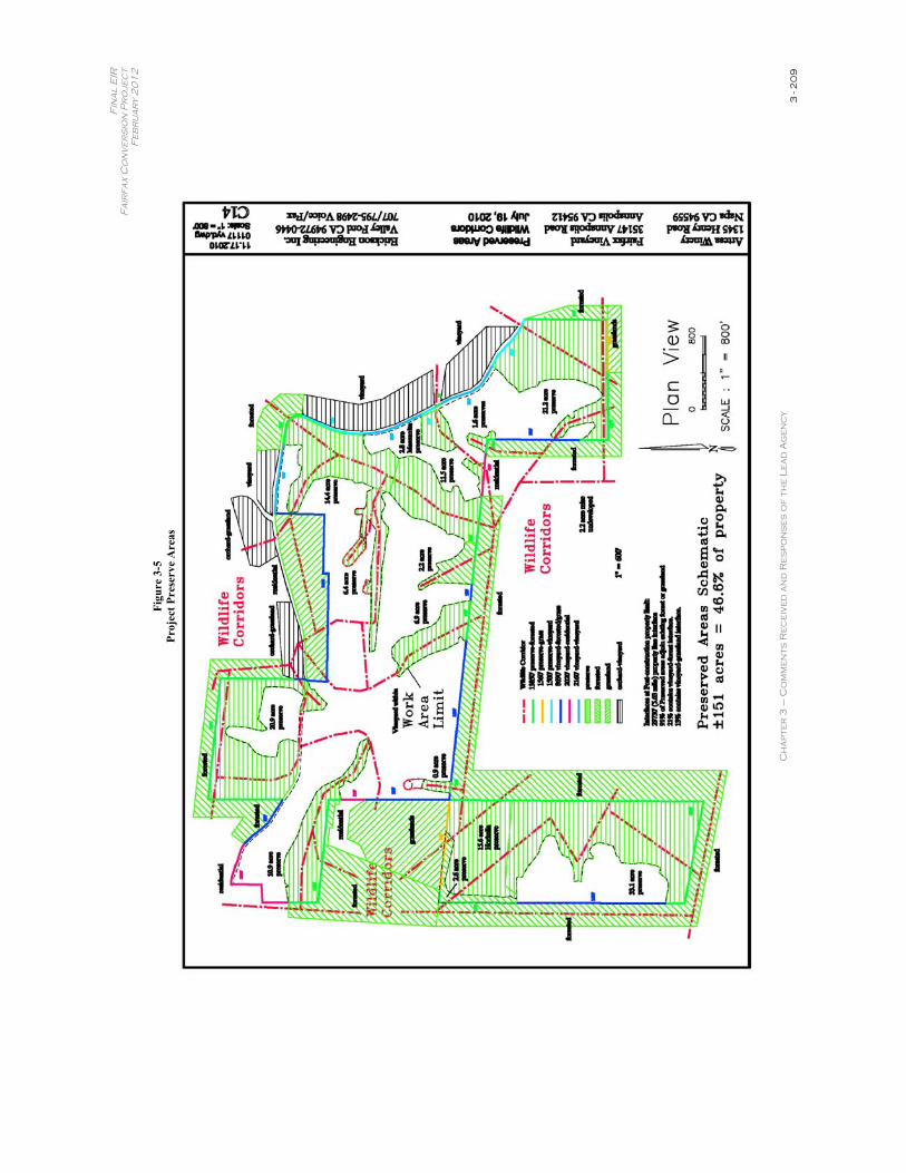
Fin
al
EIR
F
air
fax
Co
nv
er
sio
n P
ro
jec
t F
eb
ru
ar
y 2
01
2
Ch
ap
ter
3 –
Co
mm
en
ts R
ec
eiv
ed
an
d R
es
po
ns
es
of
th
e L
ea
d A
ge
nc
y 3
- 2
09
Figu
re 3
-5
Proj
ect P
rese
rve
Are
as
Final EIR Fairfax Conversion Project
February 2012
Chapter 3 – Comments Received and Responses of the Lead Agency 3 - 210
The north end of the project site was planted to apples in the late 1800s and was tended as an apple orchard until the 1950s or 1960s. Also, there are residences located on three (north, east, and west) sides of the project site. To the south, existing second growth and cut forested habitats remain. There is also an existing olive orchard immediately north and an existing vineyard immediately east of the project site. Finally, the community of Annapolis occurs immediately west of the project site. The project site is not in a pristine or undisturbed setting and it should not be characterized as such.
The setting of the project site is an important consideration, Because special-status species that are protected pursuant to the CEQA and are associated with larger stands of native forested habitat are largely missing from the project site. In addition, with the exception of Columbian black-tailed deer, large mammals are also absent from the project site. In fact almost all wildlife species that have been observed on the project site are common species found throughout northern California. While foothill yellow-legged frog, a species of special concern, is found seasonally in Patchett Creek on the project site (see DEIR), this creek is completely protected within minimum 100-foot buffers that on average extend approximately 208 feet on the project site. This frog and its habitat, which includes the stream zone and a very narrow band of upland immediately adjacent to the wetted stream zone, are completely protected on the project site.
Response to Comment 7-20
The applicant does not use netting to protect grapes from avian predation on other vineyards that have been in operation for many years. The applicant manages avian predation of grapes using reflective tape which does not have the potential to entangle birds. While the use of reflective tape is intended to continue, the applicant does not want to preclude use of netting in the future if conditions warrant such use.
Netting is typically installed after grapes form, usually in the late summer or early fall as grapes mature. Bird netting in vineyards is intended to discourage predation of grapes by common nuisance bird species such as European starlings (Sturnus vulgaris) and Brewer’s blackbirds (Euphagus cyanocephalus), which have adapted to feeding on vineyard grapes. Most migratory birds do not feed on grapes and are not likely to seek out grapes in their diets. Monk & Associates did not find evidence in the literature that demonstrates that bird netting in vineyards poses a significant hazard to foraging migratory birds and avian predators. Monk & Associates studied similar vineyards for two days in fall 2009 to examine the effects of netting over vineyards on birds to support the analysis and conclusions regarding the hazards of bird entrapment. Monk & Associates’ biologists did not observe entrapped birds in vineyard netting during the fall survey. Monk & Associates simulated bird movements by releasing multiple instances of flush coveys of California quail (Callipepla californica) found foraging on the ground around netted vineyards and observed that in almost all circumstances the birds avoided the netting. In one instance multiple quail (approximately 10 birds) were startled to an extent that they flew into the netting. However, the quail did not become entangled and immediately changed course and flew away from the netting. Birds were not observed trapped under netting and avian predators were not observed taking opportunistic advantage of entrapped or entangled prey species.
Final EIR Fairfax Conversion Project
February 2012
Chapter 3 – Comments Received and Responses of the Lead Agency 3 - 211
The project’s vineyard manager, Dr. Don Clark, has worked in vineyards and around them for many years and reports that he has seen only rare instances of trapped birds in netting. In every case, the trapped birds were European starlings. Dr. Clark has never observed a raptor trapped or injured in over-the-vine “tent” netting. The only raptor trapping he has observed involved netting over individual vine rows, which is not generally practiced today. In the past the uncovered areas between individually netted rows was an entanglement hazard. Now, netting covers entire planted areas and eliminates the nooks and crannies that can entangle birds. With current netting applications, birds (including raptors) are not able to get between netted rows and thus entanglement issues have been minimized, so as not to cause adverse effects.
When and if used, the applicant would ensure proper installation of netting, which includes the use of correct mesh size (1" to 1 1/8"), tenting grapes over multiple rows, and keeping the net from becoming slack on the ground. The installation techniques would ensure that potential prey species do not become entangled, which in turn prevents raptors from becoming entangled in the nets.
Response to Comment 7-21
The DEIR fully addressed the potential for impacts to the northern spotted owl following the standards of care required by CEQA and the California Forest Practice Rules. Please review Response to Comment 7-1 above (in particular northern spotted owl surveys).
It is the commenter’s opinion that the DEIR ignores indirect and cumulative project impacts on long-term northern spotted owl habitat suitability and maturation, compared with the consequences of vineyard conversion. As stated, CEQA requires analysis of the current condition. At this time there is no suitable habitat for the northern spotted owl on the project site and it would be unreasonable to expect the applicant to maintain current forest conditions on the site in order to create old growth forest habitat for the northern spotted owl sometime in the distant future. To presume that suitable habitat may exist in the future would be speculative at best, and would not take into account any number of stochastic events, including fire, disease, or insect infestations that would also result in prolonging, perhaps indefinitely, early seral successional stages on the project site which would not be expected to support the northern spotted owl.
The commenter is correct that barred owls (Strix varia) are moving into the Annapolis area. northern spotted owl surveys conducted in 2006, 2007, and most of 2010 did not detect this species on the project site. During a nocturnal survey on August 11, 2010, a barred owl was detected on the project site for the first time. A pair of barred owls has since been detected at various locations on the project site in three subsequent surveys conducted in 2011. Thus, M&A can confirm that an active barred owl territory is now established that includes the majority of the project site. A nocturnal survey in July 2011 detected a northern spotted owl in the vicinity south of the project site, which encountered a barred owl. The northern spotted owl was repelled by the barred owl. Subsequent surveys determined the northern spotted owl to be a transient, non-resident bird. The recovery plan for the northern spotted owl notes that hybridization among barred owls and northern spotted owls occurs occasionally, and such “hybridization with the barred owl is considered to be ‘an interesting biological phenomenon that is probably
Final EIR Fairfax Conversion Project
February 2012
Chapter 3 – Comments Received and Responses of the Lead Agency 3 - 212
inconsequential, compared with the real threat – direct competition’” between the two subspecies for food and space (2008 Final Spotted Owl Recovery Plan, p. 65-67, citing Kelly and Forsman 2004:808; see also id. at pp. 43-44.; 2010 Draft Spotted Owl Recovery Plan, pp. 85, 109). This phenomenon was observed in the vicinity of the project site.
The applicant is not responsible for the expansion of barred owls into northern California. As pointed out by the commenter, it is clear that barred owls have already expanded their range into northwestern Sonoma County and have already established territory on the project site, prior to the commencement of the project. Barred owls are among the more than 800 bird species protected under the Migratory Bird Treaty Act. Potential impacts to such species are discussed in detail in the DEIR, and mitigation measures are identified to ensure that impacts will be less-than-significant. The confirmed presence of barred owls on the site does not change the analysis or conclusions presented in the DEIR.
Habitat conditions that support this owl occur in the existing project site setting and the area around the proposed project site. It should be noted that barred owls require less heavily forested conditions than northern spotted owls, and these are the habitats that they are now moving into in addition to old growth stands. Vineyard conversion will not create habitats that would further attract barred owls. There is no demonstrated effect that vineyard conversion would enhance or create conditions that would increase barred owl populations that already exist in the project area. As noted above, the DEIR addressed potential project impacts on migratory bird species and identified mitigation measures to avoid any significant adverse effects.
The proposed project would be unlikely to provide conditions that would promote a larger barred owl population and accordingly the proposed project would not constitute a significant adverse impact to northern spotted owls pursuant to CEQA.
Response to Comment 7-22
Please see Response to Comment 7-9 regarding the nonuse of POEA on the project site.
Wetland mitigation sites located adjacent to vineyards are known to successfully support both rare amphibians and rare plants. An example is the Alton Lane vernal pool mitigation site in the Santa Rosa Plain in central Sonoma County. At the Alton Lane mitigation site, vernal pools were constructed 18 to 25 years ago. Constructed pools are as close as 20 to 30 feet from established vineyards. The vernal pools at the Alton Lane site support a breeding population of the federally listed endangered California tiger salamander (Ambystoma californiense). The created vernal pools support sensitive aquatic invertebrate species such as California linderiella (Linderiellaoccidentalis) and many other more common invertebrates. Also present in created pools at the Alton Lane mitigation site in many pools in large numbers are federally listed endangered plants that include Sonoma sunshine (Blennosperma bakeri), Burke’s goldfields (Lasthenia burkei),Sebastopol meadowfoam (Limnanthes vinculans) and Pitkin marsh lily (Lilium pardalinum ssp. pitkinense) (CNDDB 2009). Other special-status plants that have occurred for many years at Alton Lane mitigation wetland preserve include dwarf downingia (Downingia pusilla) and seaside tarplant (Hemizonia congesta ssp. congesta). The use of pesticides, herbicides, and fungicides in the vineyards surrounding the Alton Lane mitigation site have not had a
Final EIR Fairfax Conversion Project
February 2012
Chapter 3 – Comments Received and Responses of the Lead Agency 3 - 213
measureable negative effects on aquatic invertebrates, special-status amphibians, or special status plant species that include federal listed plants. Accordingly, there is substantial evidence that the proposed wetlands mitigation site within the proposed project site has a very high likelihood of success. An adjacent vineyard would not influence the success of the wetland mitigation project that would be implemented as a part of the proposed vineyard conversion project.
The goal of the wetland mitigation is to successfully emulate impacted wetlands on the site, not to promote the growth of native or special-status species in seasonal wetlands. There is no requirement pursuant to CEQA, the Clean Water Act, the Federal Endangered Species Act or the California Endangered Species Act to create high species diversity in mitigation wetland habitats. In fact, the stated objective is to replace the functions and attributes of the impacted wetlands. As pennyroyal and nutsedge occur in project site wetlands that will be impacted, it is expected that these species will also become established in the mitigation wetlands, thus replacing equivalent functions and attributes of the impacted wetlands.
Comment duly noted. Cytisus scoparius is not a special-status species that would otherwise change any conclusions regarding the significance of biological impacts from implementation of the proposed project.
Response to Comment 7-23
The DEIR comprehensively analyzed the issue of frost protection mitigation based on the project site’s specific characteristics. As the DEIR explains, “vineyard development has occurred throughout the project vicinity in recent years, concentrated in areas of gentle terrain (ridgetops), high-quality soils, and relatively frost-free environments.” (DEIR, p. 4-11.) The Project site is no exception. As part of the DEIR, a consultant engineering firm was retained to conduct a water availability evaluation for the project site. (See DEIR, Appendix P.) This evaluation, entitled Vineyard Water Availability Evaluation, concluded that the project site would not be susceptible to frost given the site’s high elevation, ridgetop location, and constant air flow. (DEIR, Appendix P, p. 2.) For these reasons, the Vineyard Water Availability Evaluation concluded that frost protection irrigation would not be necessary. (Ibid.) Based on this expert analysis, the DEIR concludes that frost protection irrigation is unnecessary at the project site. (DEIR, p. 2-24.) No additional mitigation is necessary.
Response to Comment 7-24
The DEIR does in fact provide quantitative information as to the amounts of fertilizer that will be used at the project site. As explained in the DEIR, nutrients will be utilized on an as-needed basis based on annual monitoring results. (DEIR, p. 2-25.) If fertilizer is in fact needed, the DEIR states that fertilizer will be applied only once during the growing season. (Ibid.) TheDEIR provides that on such occasion approximately 10 to 15 gallons of concentrated fertilizer would be applied per acre. (Ibid.) In addition, the DEIR states that an application of 12-26-26 fertilizer or gypsum may be used at a rate of 500 to 1,000 pounds per acre when called for, but not every year. (DEIR, p. 2-25.)
Final EIR Fairfax Conversion Project
February 2012
Chapter 3 – Comments Received and Responses of the Lead Agency 3 - 214
The DEIR analyzed potential impacts to waterbodies (e.g., Patchett Creek, Wheatfield Fork) resulting from the aforementioned fertilizer usage. The DEIR provides as follows:
As with any fertilizer application, there is potential for excessive nutrients in the site runoff to affect downstream water bodies. However, since the drip irrigation system will be used to apply fertilizers at agronomic rates (and rain is minimal during the growing season when they would be applied), it is likely that these constituents would not runoff into the surrounding streams. Furthermore the presences of 50-foot forested buffer areas between the vineyard blocks and onsite waterways [including a 100 foot buffer for Patchett Creek] will likely entrap applied fertilizers before leaving the site in the event that significant runoff does occur following an application.
(DEIR, p. 3.7-79.) The DEIR also notes that any agricultural chemicals, including fertilizers, must be applied at low, safe agronomic rates, utilizing permitted materials according to label directions and under the supervision of a qualified, trained vineyard manager. (DEIR, p. 2-25.) Given the limited application of fertilizers onsite, as well as the buffers protecting onsite waterways from the planned vineyard operations, the DEIR concluded that direct or cumulative impacts to waterbodies from fertilizer usage would be less than significant. See also Response to Comment 1-12 for the most up-to-date discussion of the buffers employed on the project site, which is hereby summarized as follows:
Figure 3-1 below provides a full description of setbacks along Patchett Creek. Protected buffers will average approximately 210 feet off the top-of-bank of this creek. The northern reach of Patchett Creek falls outside of the Timber Harvest Planning Area and thus local setbacks are not subject to the FPRs. Similarly, the northern reach of Patchett Creek on the project site is not designated in the 2020 General Plan (Figure OSRC-5a) and thus a 25-foot setback is enforceable under the General Plan. Regardless, protected buffers have been revised to provide a minimum 100-foot setback from the top of bank along the northern reach of Patchett Creek.
Riparian vegetation will be fully protected by creek buffers that are established for Patchett Creek in accordance with Section 1602 of the Fish & Game Code and as otherwise prescribed as part of the proposed project. There is a weakly formed riparian community represented mostly by interior live oaks (Quercus wislizeni), California hazelnut (Corylus cornuta var. californica), and a few California bay laurels (Umbellularia californica). In the northeastern corner of the project site, this habitat occurs along the west side of Patchett Creek and follows up a side tributary east towards Annapolis Road. All of the riparian habitat in Patchett Creek (100 percent) will be preserved. In total, there is an 11.2 acre set-aside over this portion of the project site to protect the upper reach of Patchett Creek and its riparian habitat, which also is suitable yellow warbler habitat. This preserved area is shown in the revised Vineyard Plan dated November 17, 2010. This riparian habitat will be permanently preserved via deed restriction.
Final EIR Fairfax Conversion Project
February 2012
Chapter 3 – Comments Received and Responses of the Lead Agency 3 - 215
When the project was planned, the regulations for Class III stream protection in the FPRs required that riparian setbacks for Class III tributaries, as stated in CDFG’s comment, be designated between 25 and 50 feet. Under the proposed project, all minimum Class III tributaries buffers were in compliance with the FPRs. Under the modified 2010 FPRs, the minimum buffer was revised to a minimum of 30 feet from Class III tributaries. Accordingly, all minimum buffers along Class III tributaries have been changed to reflect the new 2010 FPRs setback requirements. Pursuant to the 2010 Forest Practice Rules, the established setbacks for the proposed project on 0 to 30 percent side slopes are 30 feet. Similarly pursuant to the 2010 FPRs for slopes greater than 30 percent, minimum 50 foot buffers have been established. All Class III setbacks are now at a minimum of 30 feet from the top-of-bank, and in many cases extend much further up to 100 plus feet from the top of bank of Class III tributaries. For example, buffers established along a Class III tributary dubbed by residents as Red Fern Creek in the northwest corner of the project site will have an average protected buffer width of 85 feet.
No Class III tributary on the project site supports riparian vegetation. Rather, these tributaries support forested habitats that are non-distinguishable from the remainder of the second growth forested community on the project site. Thus, CDFG’s jurisdiction pursuant to Section 1602 of the Fish and Game Code would be to the top-of-bank with respect to Class III tributaries on the project site. As such, buffers that will be established along tributaries all comply with the FPRs and with Fish and Game Code 1602 which exerts regulatory authority over the bed, bank, and channel of tributaries, and over riparian vegetation associated with tributaries.
Response to Comment 7-25
Please see Response to Comment 6-8 for a detailed response to carbon sequestration concerns.
Response to Comment 7-26
Please see Response to Comment 7-4.
Response to Comment 7-27
Please see Response to Comment 7-1
Response to Comment 7-28
Please see Responses to Comments 7-1 to 7-24.
Response to Comment 7-29
Please see Response to Comment 7-5.

Final EIR Fairfax Conversion Project
February 2012
Chapter 3 – Comments Received and Responses of the Lead Agency 3 - 216
Response to Comment 7-30
Please see Response to Comment 7-5.
Response to Comment 7-31
Please see Responses to Comments 7-5 and 7-6.


