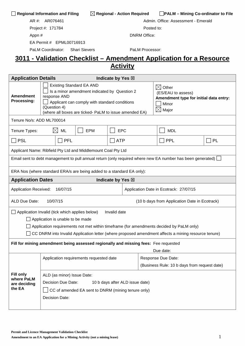
Regional Information and Filing Regional - Action Required PALM – Mining Co-ordinator to File AR #: AR076461 Admin. Office: Assessment - Emerald Project #: 171784 Posted to: Appn # DNRM Office: EA Permit # EPML00716913 PaLM Coordinator: Shari Sievers PaLM Processor: 3011 - Validation Checklist – Amendment Application for a Resource Activity Application Details Indicate by Yes Amendment Processing: Existing Standard EA AND Is a minor amendment indicated by Question 2 response AND Applicant can comply with standard conditions (Question 4) (where all boxes are ticked- PaLM to issue amended EA) Other (ES/EAU to assess) Amendment type for initial data entry: Minor Major Tenure No/s: ADD ML700014 Tenure Types: ML EPM EPC MDL PSL PFL ATP PPL PL Applicant Name: Ribfield Pty Ltd and Middlemount Coal Pty Ltd Email sent to debt management to pull annual return (only required where new EA number has been generated) ERA Nos (where standard ERA/s are being added to a standard EA only): Application Dates Indicate by Yes Application Received: 16/07/15 Application Date in Ecotrack: 27/07/15 ALD Due Date: 10/07/15 (10 b days from Application Date in Ecotrack) Application Invalid (tick which applies below) Invalid date Application is unable to be made Application requirements not met within timeframe (for amendments decided by PaLM only) CC DNRM into Invalid Application letter (where proposed amendment affects a mining resource tenure) Fill for mining amendment being assessed regionally and missing fees: Fee requested Due date: Fill only where PaLM are deciding the EA Application requirements requested date Response Due Date: (Business Rule: 10 b days from request date) ALD (as minor) Issue Date: Decision Due Date: 10 b days after ALD issue date) CC of amended EA sent to DNRM (mining tenure only) Decision Date: Permit and Licence Management Validation Checklist Amendment to an EA Application for a Mining Activity (not a mining lease) 1
Transcript
Regional Information and Filing Regional - Action Required PALM – Mining Co-ordinator to File
AR #: AR076461 Admin. Office: Assessment - Emerald
Project #: 171784 Posted to:
Appn # DNRM Office:
EA Permit # EPML00716913
PaLM Coordinator: Shari Sievers PaLM Processor:
3011 - Validation Checklist – Amendment Application for a Resource Activity
Application Details Indicate by Yes
Amendment Processing:
Existing Standard EA AND Is a minor amendment indicated by Question 2
response AND Applicant can comply with standard conditions
(Question 4) (where all boxes are ticked- PaLM to issue amended EA)
Other (ES/EAU to assess) Amendment type for initial data entry:
Minor Major
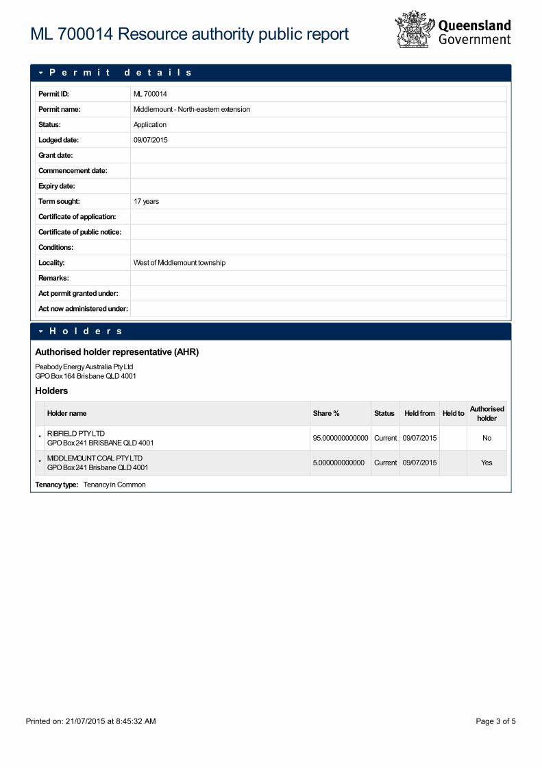
Tenure No/s: ADD ML700014
Tenure Types: ML EPM EPC MDL
PSL PFL ATP PPL PL
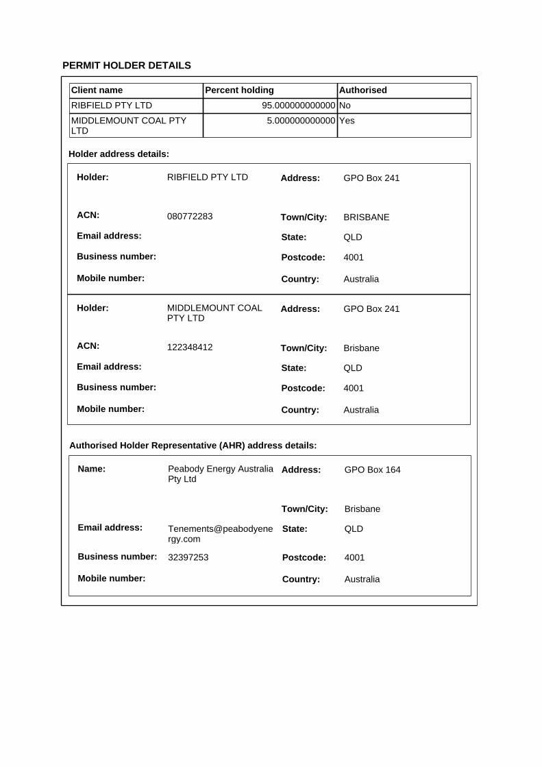
Applicant Name: Ribfield Pty Ltd and Middlemount Coal Pty Ltd
Email sent to debt management to pull annual return (only required where new EA number has been generated)
ERA Nos (where standard ERA/s are being added to a standard EA only):
Application Dates Indicate by Yes
Application Received: 16/07/15 Application Date in Ecotrack: 27/07/15
ALD Due Date: 10/07/15 (10 b days from Application Date in Ecotrack)
Application Invalid (tick which applies below) Invalid date
Application is unable to be made
Application requirements not met within timeframe (for amendments decided by PaLM only)
CC DNRM into Invalid Application letter (where proposed amendment affects a mining resource tenure)
Fill for mining amendment being assessed regionally and missing fees: Fee requested
Due date:
Fill only where PaLM are deciding the EA
Application requirements requested date Response Due Date:
(Business Rule: 10 b days from request date)
ALD (as minor) Issue Date:
Decision Due Date: 10 b days after ALD issue date) CC of amended EA sent to DNRM (mining tenure only)
Decision Date:
Permit and Licence Management Validation Checklist Amendment to an EA Application for a Mining Activity (not a mining lease) 1
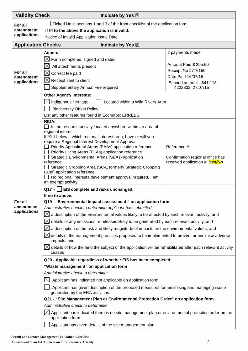
Validity Check Indicate by Yes
For all amendment applications
Ticked No in sections 1 and 3 of the front checklist of the application form if to the above the application is invalid: Notice of Invalid Application Issue Date
Application Checks Indicate by Yes
For all amendment applications For all amendment applications
Admin: Form completed, signed and dated
All attachments present
Correct fee paid Receipt sent to client
Supplementary Annual Fee required
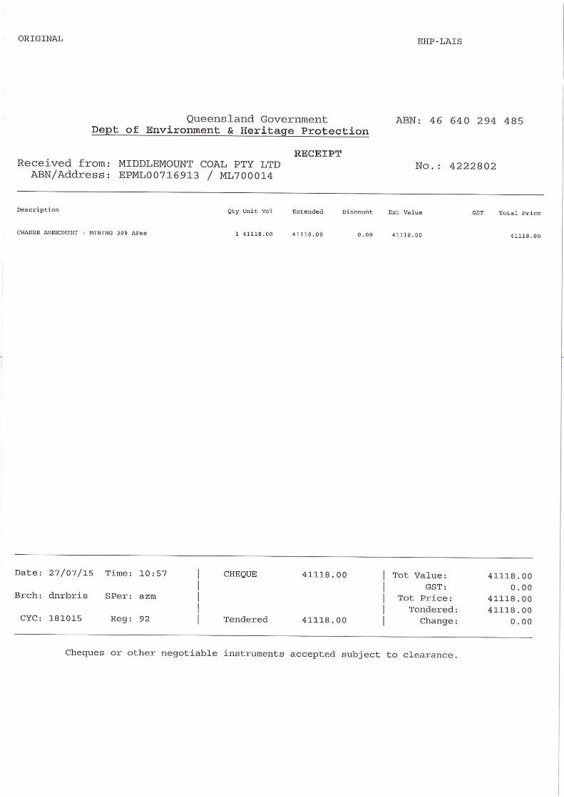
2 payments made Amount Paid $ 295.60 Receipt No 2776150 Date Paid 16/07/15 Second amount - $41,118,
4222802 27/07/15
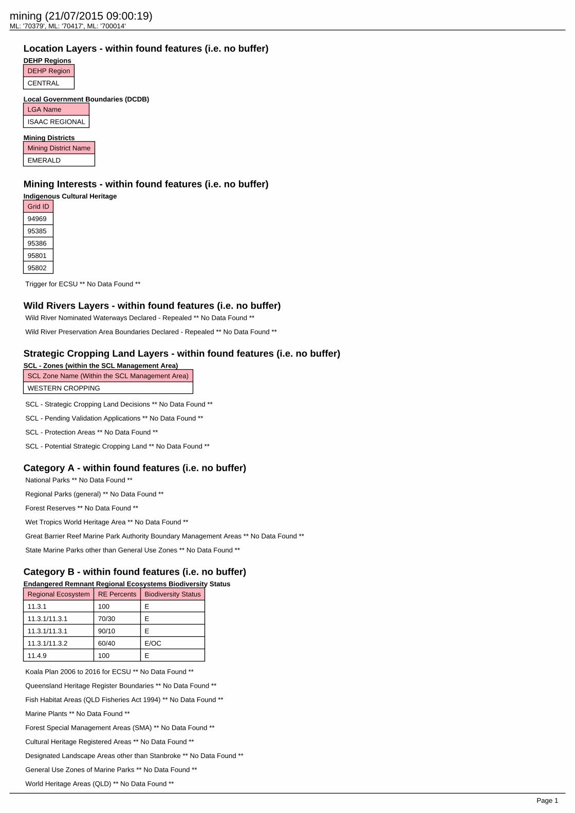
Other Agency Interests: Indigenous Heritage Located within a Wild Rivers Area
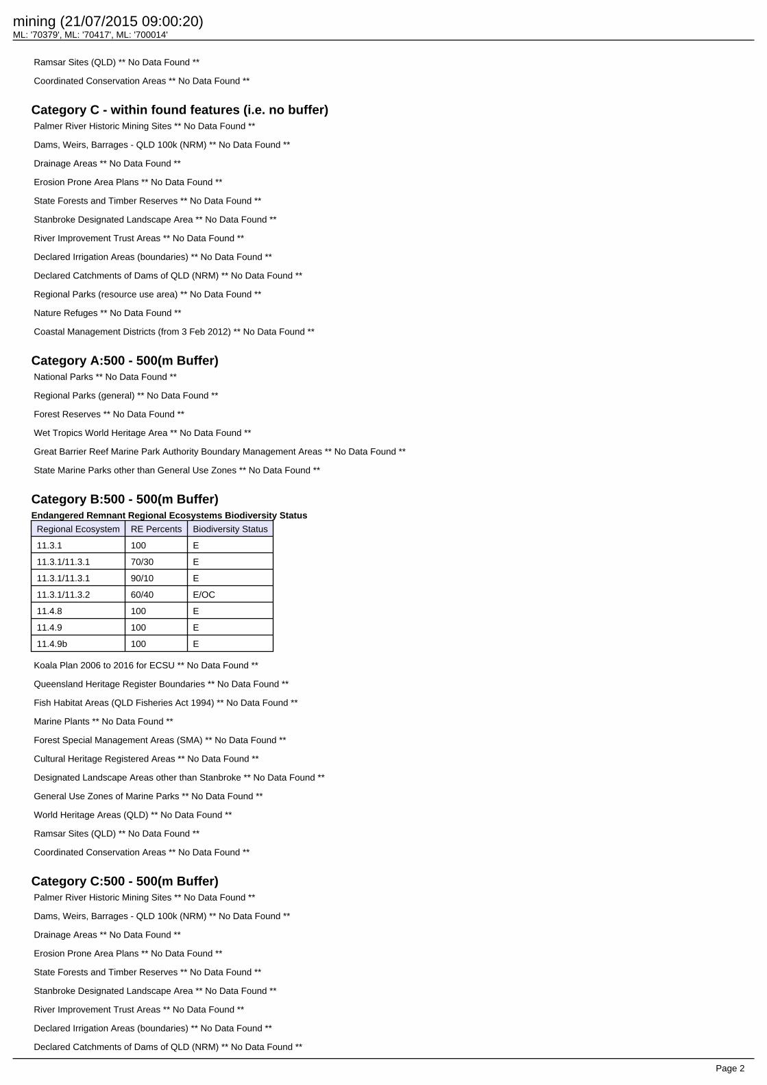
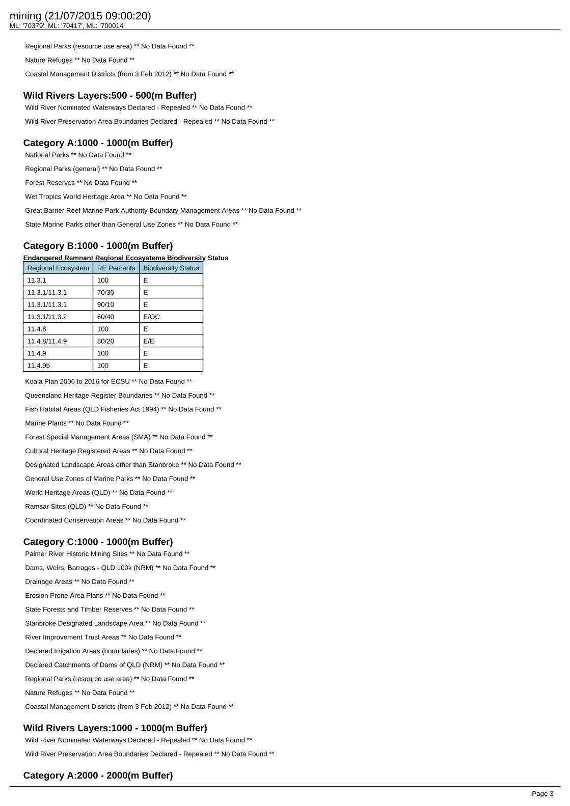
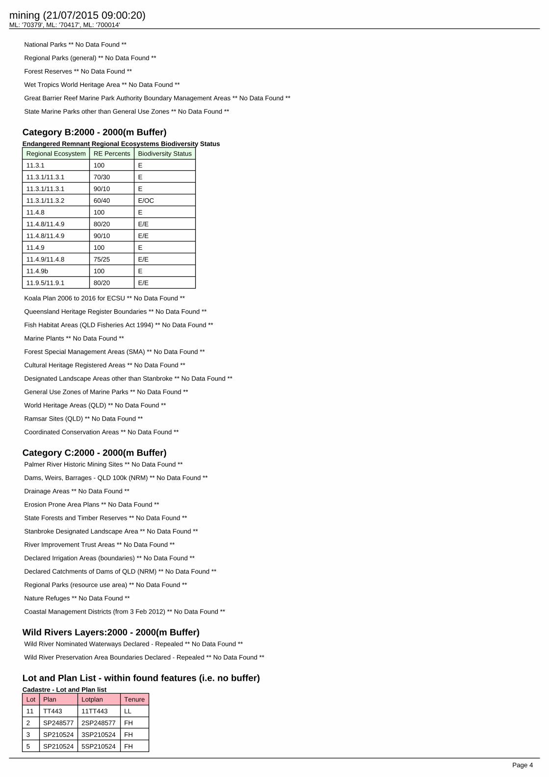
Biodiversity Offset Policy List any other features found in Ecomaps: ERREBS, RIDA:
Is the resource activity located anywhere within an area of regional interest. If fill below – which regional interest area, have or will you require a Regional Interest Development Approval
Priority Agricultural Areas (PAAs) application reference Priority Living Areas (PLAs) application reference Strategic Environmental Areas (SEAs) application
reference Strategic Cropping Area (SCA, formerly Strategic Cropping
Land) application reference No regional interests development approval required, I am
an exempt activity
Reference #: Confirmation regional office has received application #: Yes/No
Q17 - EIS complete and risks unchanged. If no to above: Q19 - “Environmental Impact assessment ” on application form Administrative check to determine applicant has submitted:
a description of the environmental values likely to be affected by each relevant activity; and
details of any emissions or releases likely to be generated by each relevant activity; and
a description of the risk and likely magnitude of impacts on the environmental values; and
details of the management practices proposed to be implemented to prevent or minimise adverse impacts; and details of how the land the subject of the application will be rehabilitated after each relevant activity ceases
Q20 - Applicable regardless of whether EIS has been completed: “Waste management” on application form Administrative check to determine:
Applicant has indicated not applicable on application form
Applicant has given description of the proposed measures for minimising and managing waste generated by the ERA activities
Q21 - “Site Management Plan or Environmental Protection Order” on application form Administrative check to determine:
Applicant has indicated there is no site management plan or environmental protection order on the application form Applicant has given details of the site management plan
Permit and Licence Management Validation Checklist Amendment to an EA Application for a Resource Activity 2
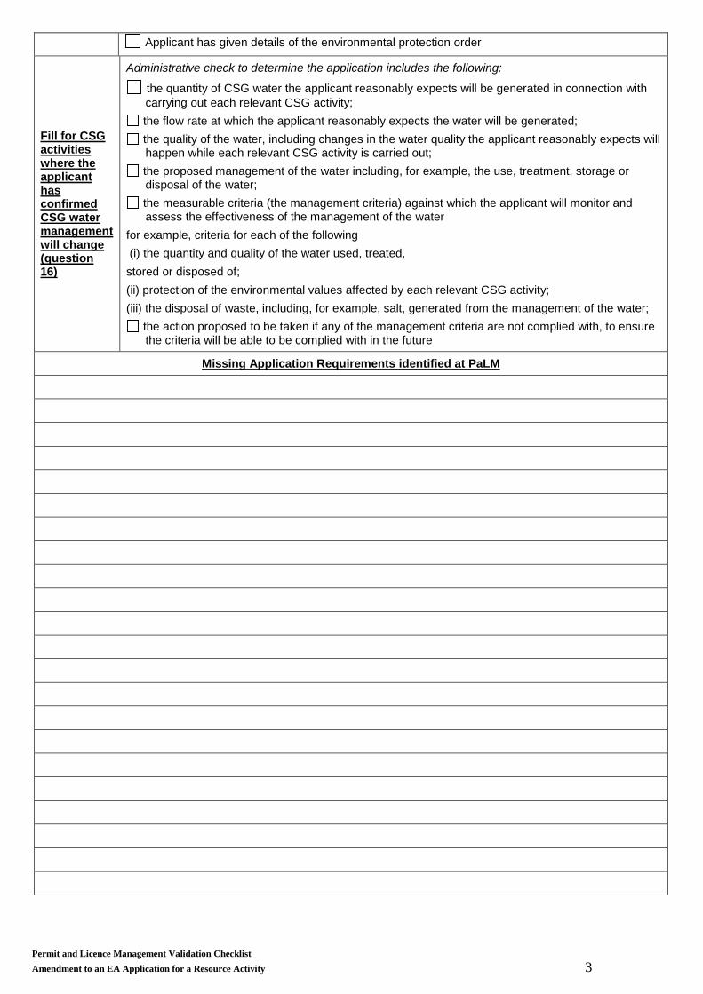
Applicant has given details of the environmental protection order
Fill for CSG activities where the applicant has confirmed CSG water management will change (question 16)
Administrative check to determine the application includes the following:
the quantity of CSG water the applicant reasonably expects will be generated in connection with carrying out each relevant CSG activity;
the flow rate at which the applicant reasonably expects the water will be generated; the quality of the water, including changes in the water quality the applicant reasonably expects will happen while each relevant CSG activity is carried out;
the proposed management of the water including, for example, the use, treatment, storage or disposal of the water;
the measurable criteria (the management criteria) against which the applicant will monitor and assess the effectiveness of the management of the water
for example, criteria for each of the following (i) the quantity and quality of the water used, treated, stored or disposed of; (ii) protection of the environmental values affected by each relevant CSG activity; (iii) the disposal of waste, including, for example, salt, generated from the management of the water;
the action proposed to be taken if any of the management criteria are not complied with, to ensure the criteria will be able to be complied with in the future
Missing Application Requirements identified at PaLM
Permit and Licence Management Validation Checklist Amendment to an EA Application for a Resource Activity 3
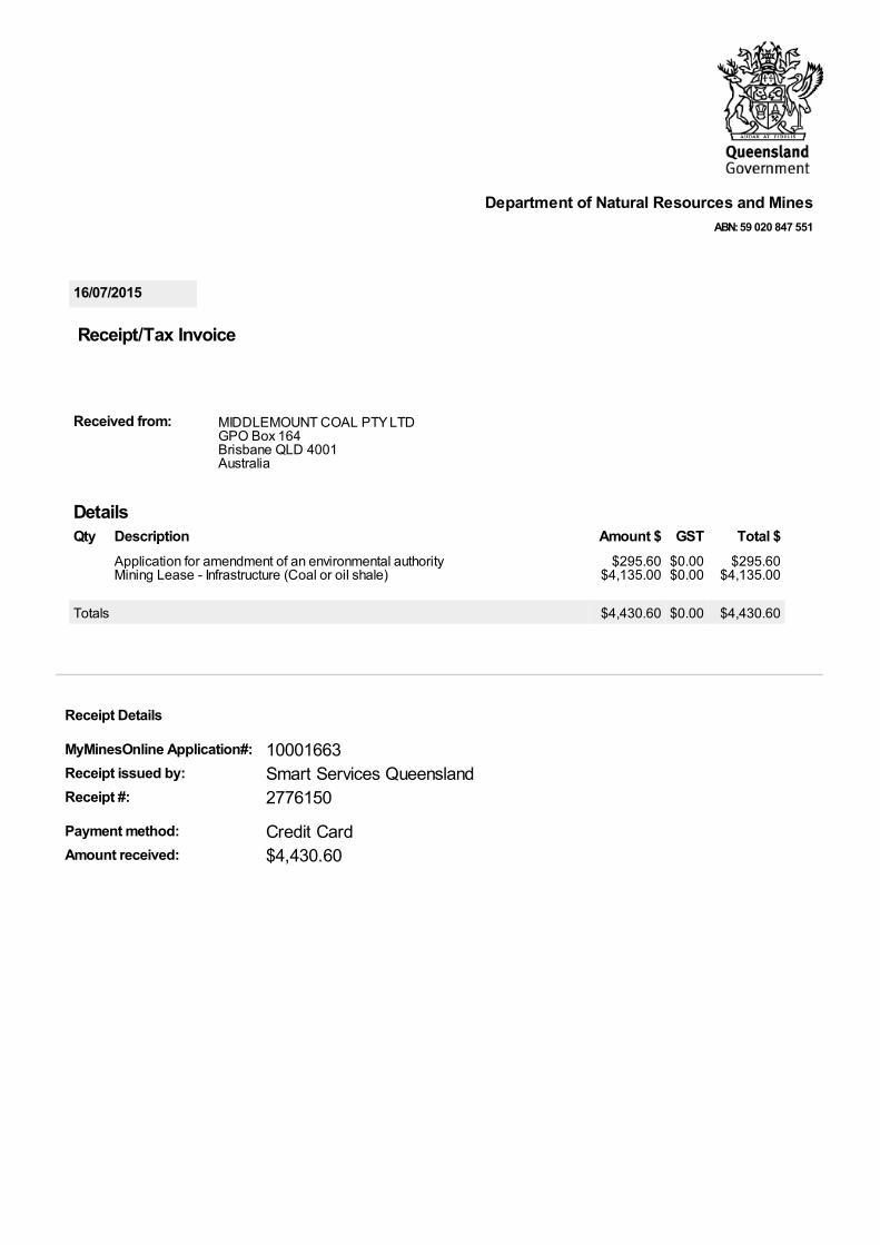
16/07/2015
DetailsQty Description Amount $ GST Total $
Application for amendment of an environmental authorityMining Lease - Infrastructure (Coal or oil shale)
$295.60$4,135.00
$0.00$0.00
$295.60$4,135.00
Totals $4,430.60 $0.00 $4,430.60
Department of Natural Resources and MinesABN: 59 020 847 551
This map has been prepared with all due diligence and care basedon the best available information at the time of publication. The departmentholds no responsibility for any errors or omissions within this document.Any decisions made by other parties based on this document are solely theresponsibility of those parties. Information contained in this documentis from a number of sources and, as such, does not necessarily representgovernment or departmental policy.
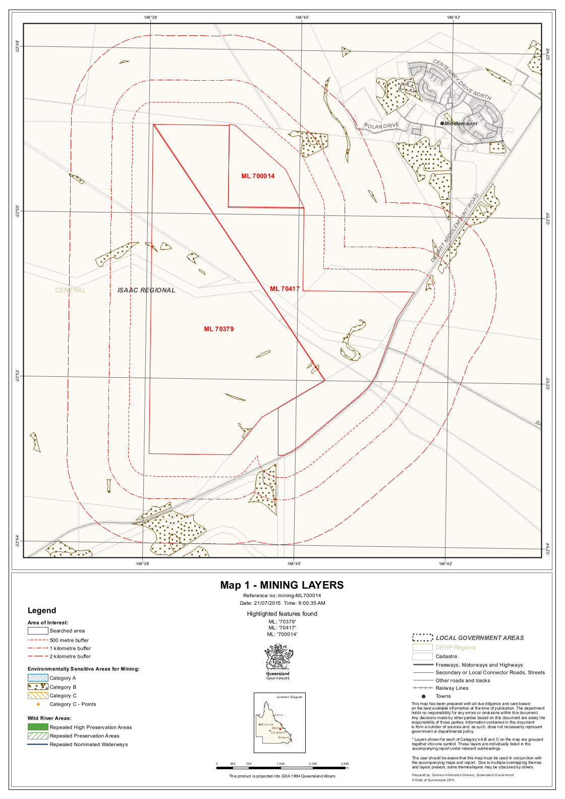
Map 1 - MINING LAYERS
Highlighted features foundML: '70379'ML: '70417'
ML: '700014'
Reference no: mining-ML700014
Repealed High Preservation AreasRepealed Preservation A reas
Category ACategory BCategory CCategory C - Points
! TownsRailway Lines
Freeways, Motorways and HighwaysSecondary or Local Connector Roads, StreetsOther roads and tracks
Cadastre
Repealed Nominated Waterways
LOCAL GOVERNMENT AREAS500 metre bufferSearched area
1 kilometre buffer2 k ilometre buffer
Legend
Environmentally Sensitive Areas for Mining:
Wild River Areas:
DEHP Regions
#
* Layers shown for each of Category’s A B and C on the map are grouped together into one symbol. These layers are individually listed in the accompanying report under relevant subheadings.The user should be aware that this map must be used in conjunction with the accompanying maps and report. Due to mult iple overlapping themes and layers present, some themes/layers may be obscured by others.
This map has been prepared with all due diligence and care basedon the best available information at the time of publication. The departmentholds no responsibility for any errors or omissions within this document.Any decisions made by other parties based on this document are solely theresponsibility of those parties. Information contained in this documentis from a number of sources and, as such, does not necessarily representgovernment or departmental policy.
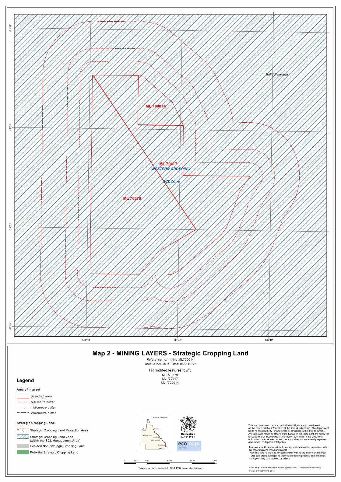
Map 2 - MINING LAYERS - Strategic Cropping Land
Highlighted features foundML: '70379'ML: '70417'
ML: '700014'
Reference no: mining-ML700014
2015
Strategic Cropping Land Protection Area
The user should be aware that this map must be used in conjunction with the accompanying maps and report:- Not all layers relevant to assessment for Mining are shown on the map. - Due to mult iple overlapping themes and layers present, some themes and layers may be obscured by others.
"
"
"
"
"
""
""
"
""
"
"
"
"
"
"
"
"
"
Strategic Cropping Land Zone (within the SCL Management Area)
The Queensland Government supports and encourages the dissemination and exchange of its information.The copyright in this publication is licensed under a Creative Commons Attribution 3.0 Australia (CC BY)licence.
Under this licence you are free, without having to seek our permission, to use this publication in accordancewith the licence terms.
You must keep intact the copyright notice and attribute the State of Queensland as the source of thepublication.
For more information on this licence, visit www.creativecommons.org/licenses/by/3.0/au/ deed.en While everycare is taken to ensure the accuracy of this product, the Queensland Government makes no representationsor warranties about its accuracy, reliability, completeness or suitability for any particular purpose and disclaimsall responsibility and all liability (including without limitation, liability in negligence) for all expenses, losses,damages (including indirect or consequential damage) and costs which you might incur as a result of theproduct being inaccurate or incomplete in any way and for any reason.
2334444445
Table of Contents
Table of ContentsPermit detailsHoldersAreaTerm historyNative titlePurpose and mineralsRelated permitsFinancialActivities
Page 3 of 21 • 141121 • EM847 • Version 7 Department of Environment and Heritage Protection
Definitions of terms used in this form
Where there is inconsistency between the definition of terms used here and the terms used in the EP Act, the
terms in the EP Act apply.
Condition conversion For an environmental authority, means an amendment replacing all the
conditions of the authority with the standard conditions for the environmentally
relevant activity which the authority relates. The relevant eligibility criteria and
standard conditions must be able to be met.
Environmentally relevant
activity (ERA)
A resource activity or a prescribed ERA
ERA project A prescribed ERA project or a resource project.
Mobile and temporary ERA A prescribed ERA, other than an activity that is dredging material, extracting
rock or other material, or the incinerating of waste:
(a) carried out at various locations using transportable plant or equipment,
including a vehicle
(b) that does not result in the building of any permanent structures or any
physical change of the landform at the locations (other than minor
alterations solely necessary for access and setup including, for example,
access ways, footings and temporary storage areas)
(c) carried out at any 1 of the locations:
(i) for less than 28 days in a calendar year, or
(ii) for 28 or more days in a calendar year only if the activity is
necessarily associated with, and is exclusively used in, the
construction or demolition phase of a project.
Prescribed ERA An environmentally relevant activity that is not a resource activity and is
prescribed under section 19 of the EP Act.
Prescribed ERA project All prescribed ERAs carried out, or proposed to be carried out, as a single
integrated operation.
Registered suitable operator A person who, or a corporation which, under section 318I of the EP Act has
been assessed as being suitable to carry out an ERA and has been listed on
the suitable operator register.
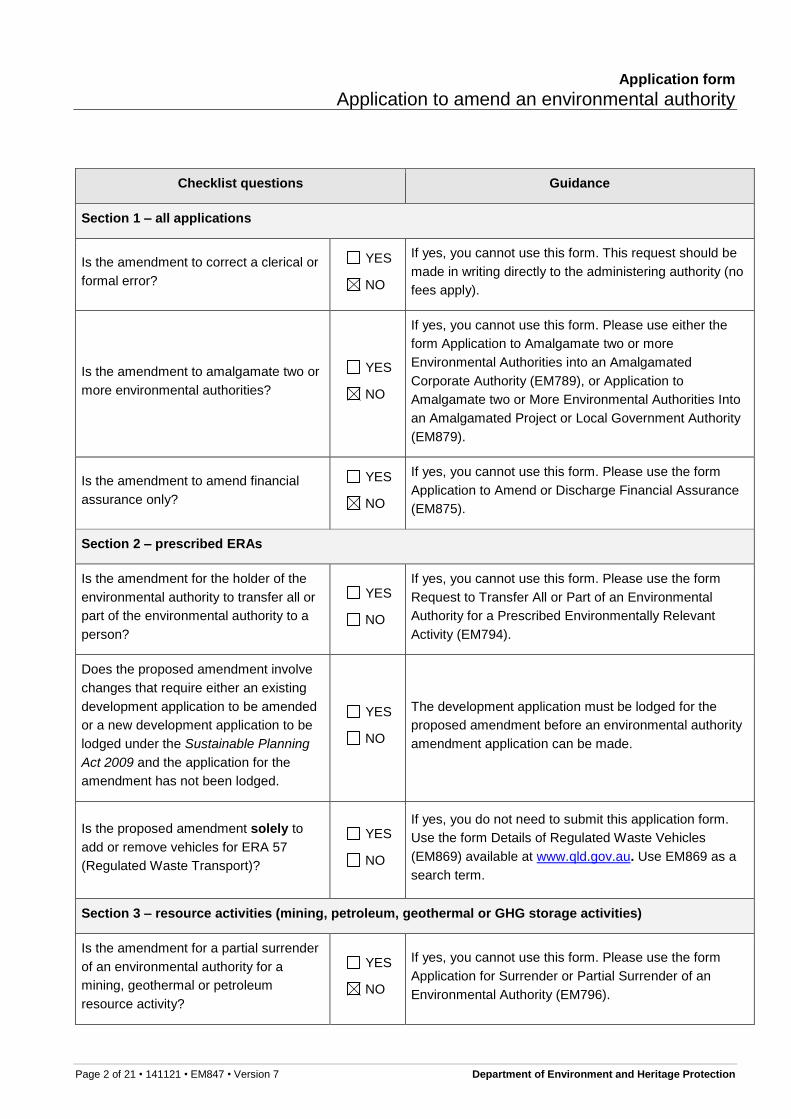
Application form
Application to amend an environmental authority
Page 4 of 21 • 141121 • EM847 • Version 7 Department of Environment and Heritage Protection
Resource activity An activity that is any of the following:
(a) a geothermal activity
(b) a greenhouse gas (GHG) storage activity
(c) a mining activity
(d) a petroleum activity.
Resource project Resource activities carried out, or proposed to be carried out, under 1 or more
resource tenures, in any combination, as a single integrated operation.
Significant project A project declared under section 26 of the State Development and Public
Works Act 1971 to be a significant project.
Single integrated operation Occurs when all the below criteria is met:
(a) the activities are carried out under the day-to-day management of a
single responsible individual, for example, a site or operations manager
(b) the activities are operationally interrelated
(c) the activities are, or will be, carried out at 1 or more places
(d) the places where the activities are carried out are separated by distances
short enough to make feasible the integrated day-to-day management of
the activities.
Application form
Application to amend an environmental authority
Page 5 of 21 • 141121 • EM847 • Version 7 Department of Environment and Heritage Protection
GUIDE
If you require assistance in answering any part of this form, or have any questions about your application please contact the relevant department. Contact details are at the end of this form
The environmental authority number and details may be found on the existing environmental authority or quoted in other correspondence received from the administering authority.
If more space is required for any responses, please attach additional information as a separate page.
If there is an agent acting on behalf of the environmental authority holder, provide details in this section. An agent could be a consultant or a contact for the environmental authority holder.
As statutory documents need to be sent to all applicants, this section can also be used when there are multiple environmental authority holders to nominate an address for statutory documentation to be sent ‘care of’ to.
Application details
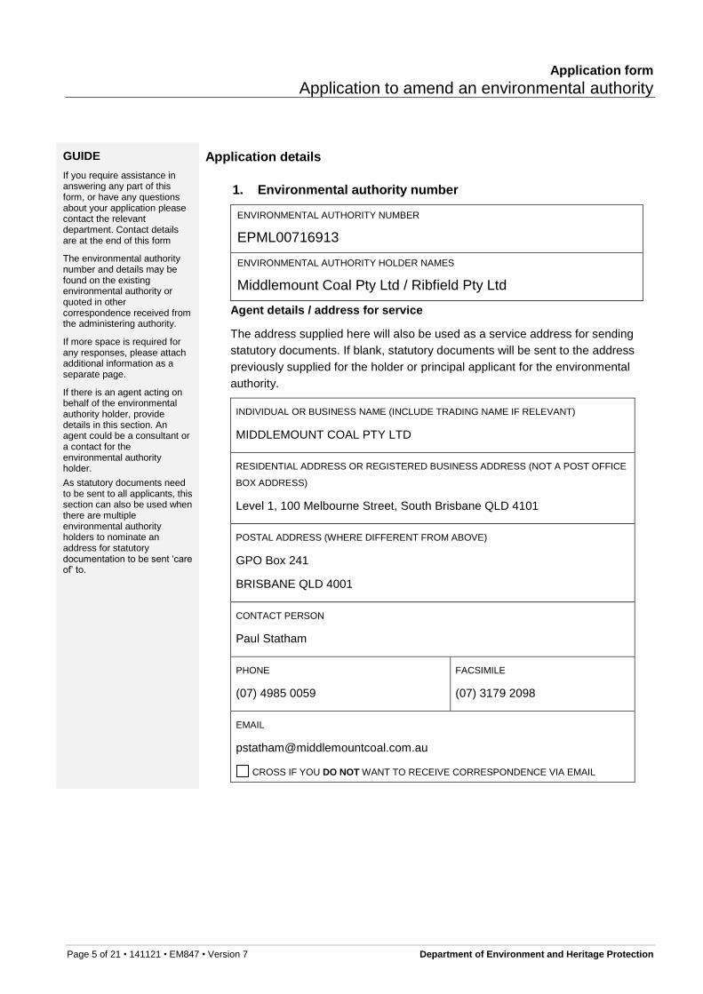
1. Environmental authority number
ENVIRONMENTAL AUTHORITY NUMBER
EPML00716913
ENVIRONMENTAL AUTHORITY HOLDER NAMES
Middlemount Coal Pty Ltd / Ribfield Pty Ltd
Agent details / address for service
The address supplied here will also be used as a service address for sending
statutory documents. If blank, statutory documents will be sent to the address
previously supplied for the holder or principal applicant for the environmental
authority.
INDIVIDUAL OR BUSINESS NAME (INCLUDE TRADING NAME IF RELEVANT)
MIDDLEMOUNT COAL PTY LTD
RESIDENTIAL ADDRESS OR REGISTERED BUSINESS ADDRESS (NOT A POST OFFICE
BOX ADDRESS)
Level 1, 100 Melbourne Street, South Brisbane QLD 4101
CROSS IF YOU DO NOT WANT TO RECEIVE CORRESPONDENCE VIA EMAIL
Application form
Application to amend an environmental authority
Page 6 of 21 • 141121 • EM847 • Version 7 Department of Environment and Heritage Protection
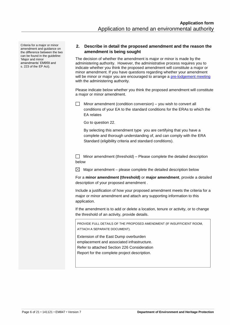
Criteria for a major or minor amendment and guidance on the difference between the two can be found in the guideline: ‘Major and minor amendments’ EM959 and s. 223 of the EP Act).
2. Describe in detail the proposed amendment and the reason the
amendment is being sought
The decision of whether the amendment is major or minor is made by the administering authority. However, the administrative process requires you to indicate whether you think the proposed amendment will constitute a major or minor amendment. If you have questions regarding whether your amendment will be minor or major you are encouraged to arrange a pre-lodgement meeting with the administering authority. Please indicate below whether you think the proposed amendment will constitute a major or minor amendment.
Minor amendment (condition conversion) – you wish to convert all
conditions of your EA to the standard conditions for the ERAs to which the
EA relates
Go to question 22.
By selecting this amendment type you are certifying that you have a
complete and thorough understanding of, and can comply with the ERA
Standard (eligibility criteria and standard conditions).
Minor amendment (threshold) – Please complete the detailed description
below
Major amendment – please complete the detailed description below
For a minor amendment (threshold) or major amendment, provide a detailed
description of your proposed amendment .
Include a justification of how your proposed amendment meets the criteria for a
major or minor amendment and attach any supporting information to this
application.
If the amendment is to add or delete a location, tenure or activity, or to change
the threshold of an activity, provide details.
PROVIDE FULL DETAILS OF THE PROPOSED AMENDMENT (IF INSUFFICIENT ROOM,
Page 7 of 21 • 141121 • EM847 • Version 7 Department of Environment and Heritage Protection
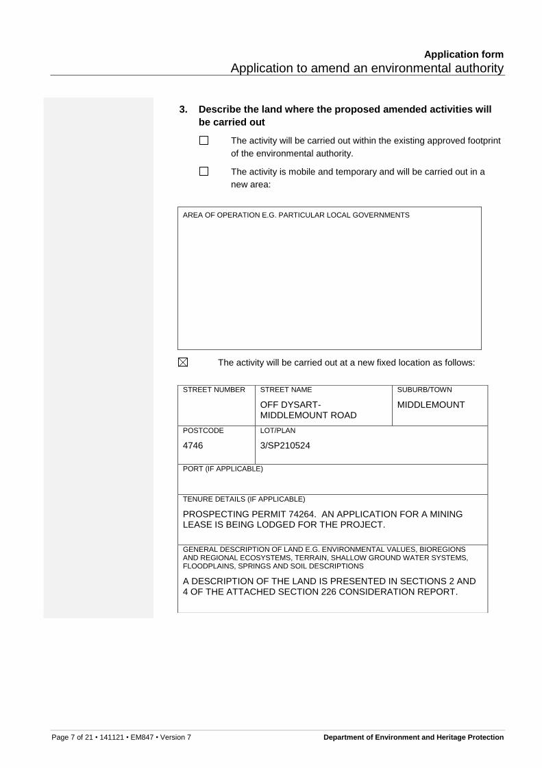
3. Describe the land where the proposed amended activities will
be carried out
The activity will be carried out within the existing approved footprint
of the environmental authority.
The activity is mobile and temporary and will be carried out in a
new area:
AREA OF OPERATION E.G. PARTICULAR LOCAL GOVERNMENTS
The activity will be carried out at a new fixed location as follows:
STREET NUMBER
STREET NAME
OFF DYSART-MIDDLEMOUNT ROAD
SUBURB/TOWN
MIDDLEMOUNT
POSTCODE
4746
LOT/PLAN
3/SP210524
PORT (IF APPLICABLE)
TENURE DETAILS (IF APPLICABLE)
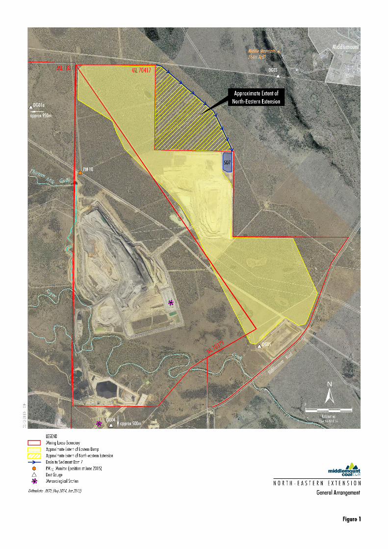
PROSPECTING PERMIT 74264. AN APPLICATION FOR A MINING LEASE IS BEING LODGED FOR THE PROJECT.
GENERAL DESCRIPTION OF LAND E.G. ENVIRONMENTAL VALUES, BIOREGIONS AND REGIONAL ECOSYSTEMS, TERRAIN, SHALLOW GROUND WATER SYSTEMS, FLOODPLAINS, SPRINGS AND SOIL DESCRIPTIONS
A DESCRIPTION OF THE LAND IS PRESENTED IN SECTIONS 2 AND 4 OF THE ATTACHED SECTION 226 CONSIDERATION REPORT.
Application form
Application to amend an environmental authority
Page 8 of 21 • 141121 • EM847 • Version 7 Department of Environment and Heritage Protection
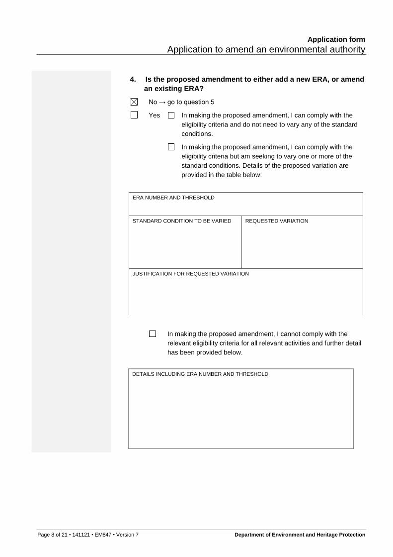
4. Is the proposed amendment to either add a new ERA, or amend
an existing ERA?
No → go to question 5
Yes In making the proposed amendment, I can comply with the
eligibility criteria and do not need to vary any of the standard
conditions.
In making the proposed amendment, I can comply with the
eligibility criteria but am seeking to vary one or more of the
standard conditions. Details of the proposed variation are
provided in the table below:
ERA NUMBER AND THRESHOLD
STANDARD CONDITION TO BE VARIED
REQUESTED VARIATION
JUSTIFICATION FOR REQUESTED VARIATION
In making the proposed amendment, I cannot comply with the
relevant eligibility criteria for all relevant activities and further detail
has been provided below.
DETAILS INCLUDING ERA NUMBER AND THRESHOLD
Application form
Application to amend an environmental authority
Page 9 of 21 • 141121 • EM847 • Version 7 Department of Environment and Heritage Protection
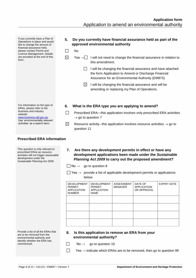
If you currently have a Plan of Operations in place and would like to change the amount of financial assurance held, please contact Permit and Licence Management. Details are provided at the end of this form.
5. Do you currently have financial assurance held as part of the
approved environmental authority
No
Yes → I will not need to change the financial assurance in relation to
this amendment.
I will be changing the financial assurance and have attached
the form Application to Amend or Discharge Financial
Assurance for an Environmental Authority (EM875)
I will be changing the financial assurance and will be
amending or replacing my Plan of Operations.
For information on the type of ERAs, please refer to the business and industry website: www.business.qld.gov.au. Use ‘environmentally relevant activities’ as a search term.
6. What is the ERA type you are applying to amend?
Prescribed ERA—this application involves only prescribed ERA activities
go to question 7
Resource activity—this application involves resource activities go to
question 11
Prescribed ERA information
This question is only relevant to prescribed ERAs as resource activities will not trigger assessable development under the Sustainable Planning Act 2009.
7. Are there any development permits in effect or have any
development applications been made under the Sustainable
Planning Act 2009 to carry out the proposed amendment?
No → go to question 8
Yes → provide a list of applicable development permits or applications
below
DEVELOPMENT PERMIT/ APPLICATION NUMBER
DEVELOPMENT PERMIT/ APPLICATION NAME
ASSESSMENT MANAGER
DATE OF APPLICATION OR APPROVAL
EXPIRY DATE
Provide a list of all the ERAs that are to be removed from the environmental authority and identify whether the ERA has commenced.
8. Is this application to remove an ERA from your
environmental authority?
No → go to question 15
Yes → indicate which ERAs are to be removed, then go to question 99
Page 10 of 21 • 141121 • EM847 • Version 7 Department of Environment and Heritage Protection
ERA NUMBER AND NAME
THRESHOLD HAS THE ERA COMMENCED? (YES/NO)
LOCATION (INCLUDING ALL LOT ON PLAN/TENURE DETAILS)
If you have identified above that any of the ERAs have not commenced,
please complete the below:
I declare that where identified, the ERAs above have not commenced.
The final rehabilitation report must be completed in the correct template and contain all the information specified in the template. The final rehabilitation report template is available at www.qld.gov.au using the publication number (EM872) as a search term.
9. Does your environmental authority contain any rehabilitation
conditions that are applicable to the ERAs that you are
requesting be removed from the environmental authority?
Yes → you must attach a final rehabilitation report
No
Only a person with appropriate environmental expertise and/or experience in planning and executing site operations should sign this compliance statement. This person may be the environmental authority holder, a full time employee of the environmental authority holder or a consultant to the environmental authority holder.
Methods to verify compliance may include a desktop assessment of documentation, an interview with the landowner/holder or a field operator or a site inspection. Evidence used may include photographs, statements and other documentation (maps, plans, approvals, monitoring results etc.).
10. Compliance statement
This compliance statement must be completed by, or on behalf of the
environmental authority holder. Once completed, go to question 15
Attach a separate document to this application form which states the extent to
which:
the ERAs being removed from the environmental authority have
complied with each relevant condition of approval
the final rehabilitation report is accurate (include the date of the final
rehabilitation report). Note: The compliance statement only needs to be
made for the final rehabilitation report if the answer to question 9 is ‘Yes’
Describe the qualifications and experience of the person signing the
compliance statement.
Provide details of the date, method and evidence used to verify compliance
and accuracy.
Application form
Application to amend an environmental authority
Page 11 of 21 • 141121 • EM847 • Version 7 Department of Environment and Heritage Protection
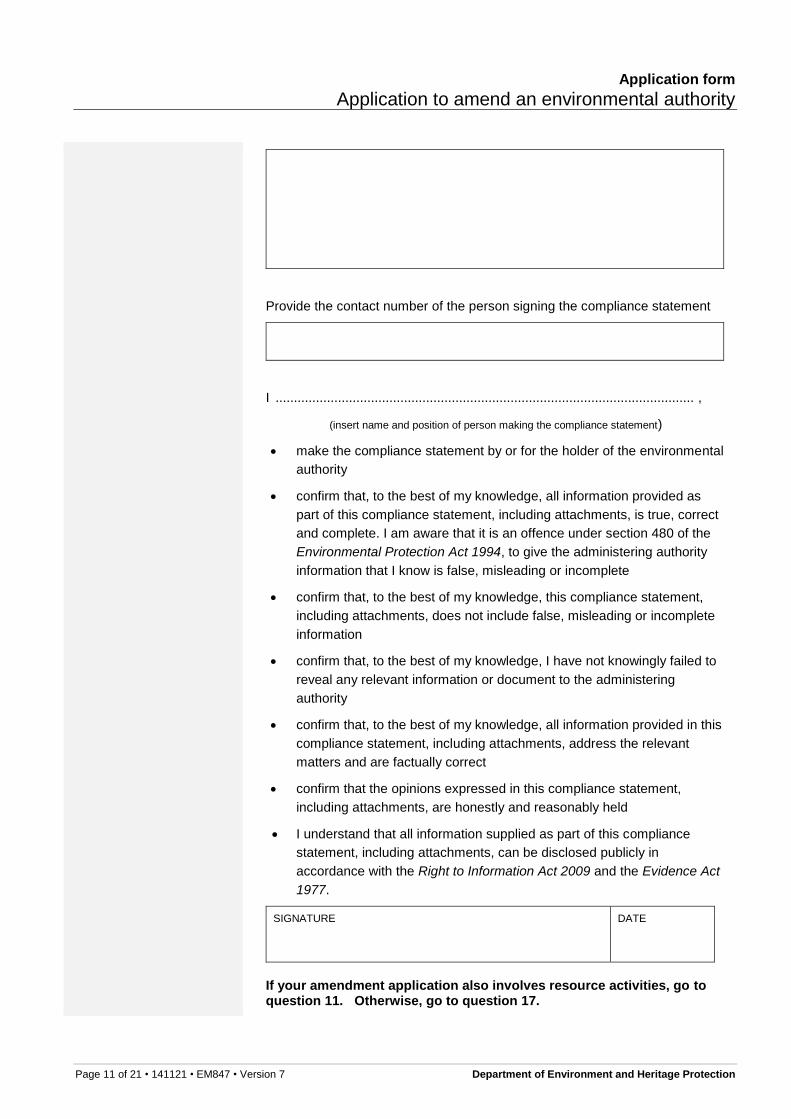
Provide the contact number of the person signing the compliance statement
I .................................................................................................................. ,
(insert name and position of person making the compliance statement)
make the compliance statement by or for the holder of the environmental
authority
confirm that, to the best of my knowledge, all information provided as
part of this compliance statement, including attachments, is true, correct
and complete. I am aware that it is an offence under section 480 of the
Environmental Protection Act 1994, to give the administering authority
information that I know is false, misleading or incomplete
confirm that, to the best of my knowledge, this compliance statement,
including attachments, does not include false, misleading or incomplete
information
confirm that, to the best of my knowledge, I have not knowingly failed to
reveal any relevant information or document to the administering
authority
confirm that, to the best of my knowledge, all information provided in this
compliance statement, including attachments, address the relevant
matters and are factually correct
confirm that the opinions expressed in this compliance statement,
including attachments, are honestly and reasonably held
I understand that all information supplied as part of this compliance
statement, including attachments, can be disclosed publicly in
accordance with the Right to Information Act 2009 and the Evidence Act
1977.
SIGNATURE DATE
If your amendment application also involves resource activities, go to question 11. Otherwise, go to question 17.
Application form
Application to amend an environmental authority
Page 12 of 21 • 141121 • EM847 • Version 7 Department of Environment and Heritage Protection
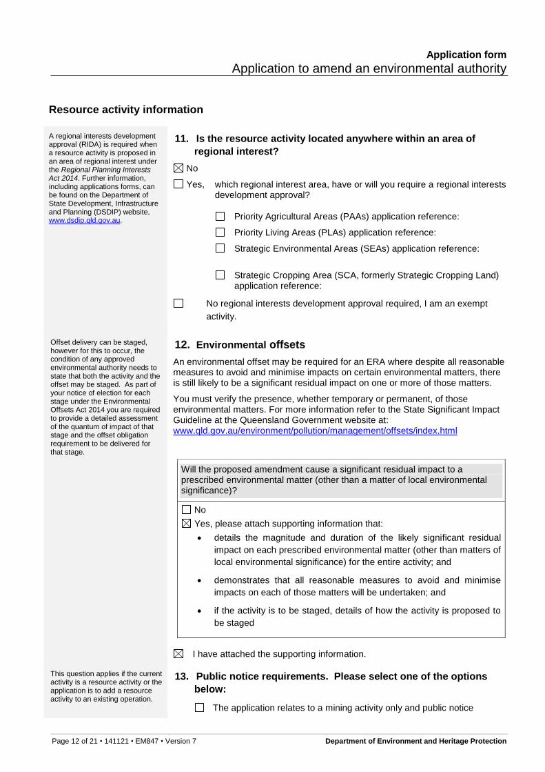
Resource activity information
A regional interests development approval (RIDA) is required when a resource activity is proposed in an area of regional interest under the Regional Planning Interests Act 2014. Further information, including applications forms, can be found on the Department of State Development, Infrastructure and Planning (DSDIP) website, www.dsdip.qld.gov.au.
11. Is the resource activity located anywhere within an area of
regional interest?
No
Yes, which regional interest area, have or will you require a regional interests development approval?
Priority Agricultural Areas (PAAs) application reference:
Priority Living Areas (PLAs) application reference:
Strategic Environmental Areas (SEAs) application reference:
Strategic Cropping Area (SCA, formerly Strategic Cropping Land) application reference:
No regional interests development approval required, I am an exempt
activity.
Offset delivery can be staged, however for this to occur, the condition of any approved environmental authority needs to state that both the activity and the offset may be staged. As part of your notice of election for each stage under the Environmental Offsets Act 2014 you are required to provide a detailed assessment of the quantum of impact of that stage and the offset obligation requirement to be delivered for that stage.
12. Environmental offsets
An environmental offset may be required for an ERA where despite all reasonable measures to avoid and minimise impacts on certain environmental matters, there is still likely to be a significant residual impact on one or more of those matters.
You must verify the presence, whether temporary or permanent, of those environmental matters. For more information refer to the State Significant Impact Guideline at the Queensland Government website at: www.qld.gov.au/environment/pollution/management/offsets/index.html
Will the proposed amendment cause a significant residual impact to a prescribed environmental matter (other than a matter of local environmental significance)?
No
Yes, please attach supporting information that:
details the magnitude and duration of the likely significant residual
impact on each prescribed environmental matter (other than matters of
local environmental significance) for the entire activity; and
demonstrates that all reasonable measures to avoid and minimise
impacts on each of those matters will be undertaken; and
if the activity is to be staged, details of how the activity is proposed to
be staged
I have attached the supporting information.
This question applies if the current activity is a resource activity or the application is to add a resource activity to an existing operation.
13. Public notice requirements. Please select one of the options
below:
The application relates to a mining activity only and public notice
Page 13 of 21 • 141121 • EM847 • Version 7 Department of Environment and Heritage Protection
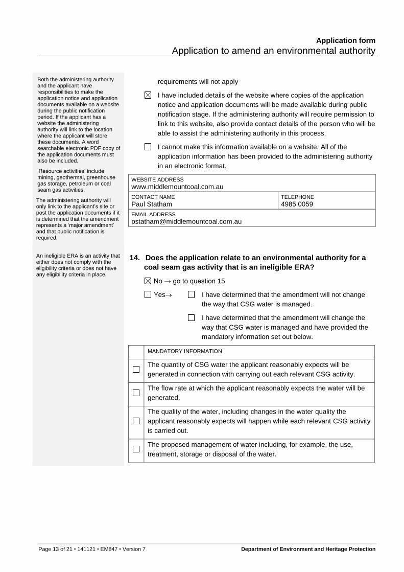
Both the administering authority and the applicant have responsibilities to make the application notice and application documents available on a website during the public notification period. If the applicant has a website the administering authority will link to the location where the applicant will store these documents. A word searchable electronic PDF copy of the application documents must also be included.
‘Resource activities’ include mining, geothermal, greenhouse gas storage, petroleum or coal seam gas activities.
The administering authority will only link to the applicant’s site or post the application documents if it is determined that the amendment represents a ‘major amendment’ and that public notification is required.
requirements will not apply
I have included details of the website where copies of the application
notice and application documents will be made available during public
notification stage. If the administering authority will require permission to
link to this website, also provide contact details of the person who will be
able to assist the administering authority in this process.
I cannot make this information available on a website. All of the
application information has been provided to the administering authority
An ineligible ERA is an activity that either does not comply with the eligibility criteria or does not have any eligibility criteria in place.
14. Does the application relate to an environmental authority for a
coal seam gas activity that is an ineligible ERA?
No → go to question 15
Yes I have determined that the amendment will not change
the way that CSG water is managed.
I have determined that the amendment will change the
way that CSG water is managed and have provided the
mandatory information set out below.
MANDATORY INFORMATION
The quantity of CSG water the applicant reasonably expects will be
generated in connection with carrying out each relevant CSG activity.
The flow rate at which the applicant reasonably expects the water will be
generated.
The quality of the water, including changes in the water quality the
applicant reasonably expects will happen while each relevant CSG activity
is carried out.
The proposed management of water including, for example, the use,
treatment, storage or disposal of the water.
Application form
Application to amend an environmental authority
Page 14 of 21 • 141121 • EM847 • Version 7 Department of Environment and Heritage Protection
The measurable criteria (‘management criteria’) against which the
applicant will monitor and assess the effectiveness of the management of
the water, including, for example, criteria for each of the following:
(i) the quantity and quality of the water used, treated, stored or disposed
of
(ii) protection of the environmental values affected by each relevant CSG
activity
(iii) the disposal of waste, including, for example, salt, generated for the
management of the water.
The action proposed to be taken if any of the management criteria are not
complied with, to ensure that the criteria will be able to be complied with in
the future.
If the application includes a CSG evaporation dam, an evaluation of the
following must be provided:
(i) best practice environmental management for managing CSG water
(ii) alternative ways for managing CSG water
(iii) whether there is a feasible alternative to a CSG evaporation dam for
managing the water. Note if the evaluation shows that there is a
feasible alternative option, the CSG evaporation dam cannot form part
of the water management for this amendment application.
General ERA information
Completion of an EIS process is defined in section 60 of the EP Act.
15. Has an environmental impact statement (EIS) process that
includes the proposed amendment, been completed?
No
Yes → I have assessed the environmental risks of the proposed
amendment and consider them to be the same as was
assessed in the EIS. A copy of the assessment is
attached. Go to question 18
I have assessed the environmental risks of the proposed
amendment and consider them to be different to what
was assessed in the EIS. Go to question 16
The information provided here will assist the administering authority in deciding whether an EIS is required.
For further information refer to the guideline: Triggers for Environmental Impact Statements under the Environmental Protection Act 1994 for mining, petroleum and gas activities. This
16. EIS triggers
Questions Select Give details or attach documentation to support your answer
Application form
Application to amend an environmental authority
Page 15 of 21 • 141121 • EM847 • Version 7 Department of Environment and Heritage Protection
guideline is available at www.qld.gov.au, using the search term ‘triggers for environmental impact statements’.
Page 16 of 21 • 141121 • EM847 • Version 7 Department of Environment and Heritage Protection
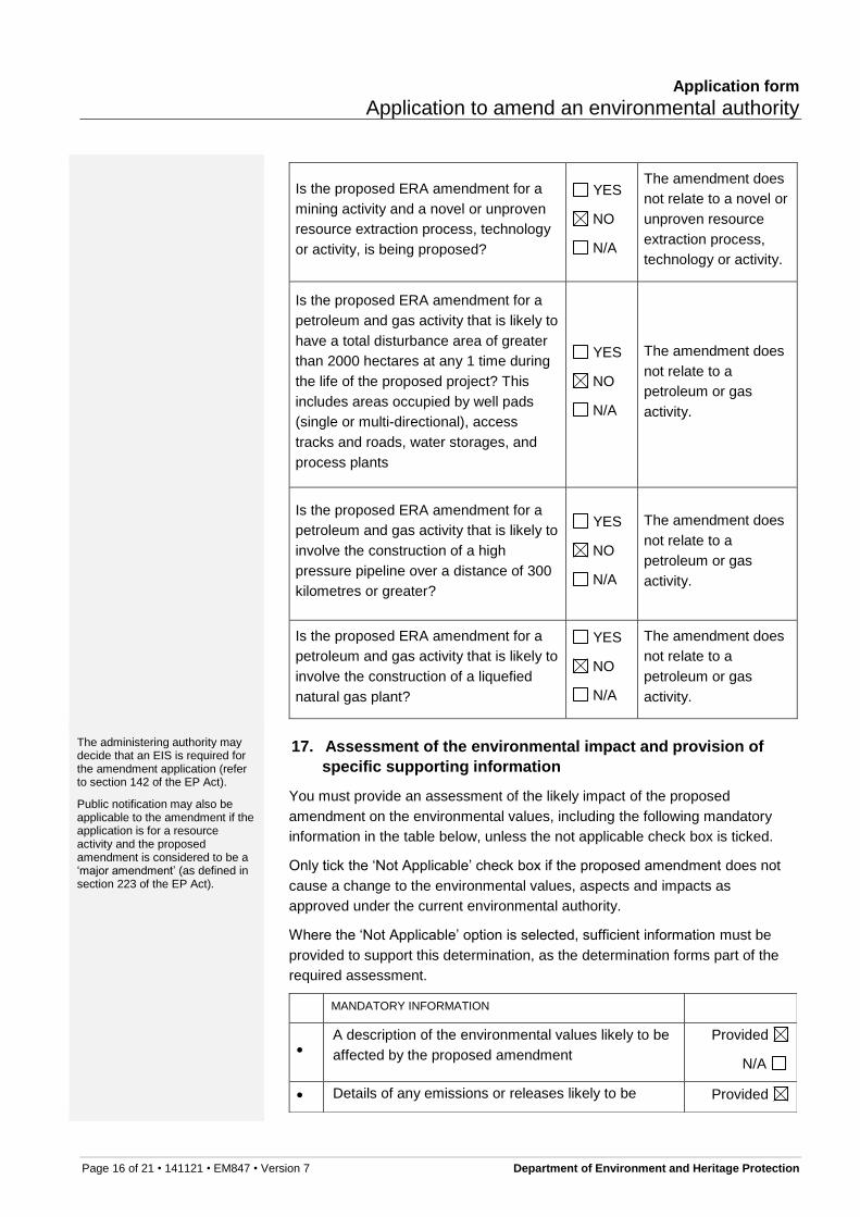
Is the proposed ERA amendment for a
mining activity and a novel or unproven
resource extraction process, technology
or activity, is being proposed?
YES
NO
N/A
The amendment does
not relate to a novel or
unproven resource
extraction process,
technology or activity.
Is the proposed ERA amendment for a
petroleum and gas activity that is likely to
have a total disturbance area of greater
than 2000 hectares at any 1 time during
the life of the proposed project? This
includes areas occupied by well pads
(single or multi-directional), access
tracks and roads, water storages, and
process plants
YES
NO
N/A
The amendment does
not relate to a
petroleum or gas
activity.
Is the proposed ERA amendment for a
petroleum and gas activity that is likely to
involve the construction of a high
pressure pipeline over a distance of 300
kilometres or greater?
YES
NO
N/A
The amendment does
not relate to a
petroleum or gas
activity.
Is the proposed ERA amendment for a
petroleum and gas activity that is likely to
involve the construction of a liquefied
natural gas plant?
YES
NO
N/A
The amendment does
not relate to a
petroleum or gas
activity.
The administering authority may decide that an EIS is required for the amendment application (refer to section 142 of the EP Act).
Public notification may also be applicable to the amendment if the application is for a resource activity and the proposed amendment is considered to be a ‘major amendment’ (as defined in section 223 of the EP Act).
17. Assessment of the environmental impact and provision of
specific supporting information
You must provide an assessment of the likely impact of the proposed
amendment on the environmental values, including the following mandatory
information in the table below, unless the not applicable check box is ticked.
Only tick the ‘Not Applicable’ check box if the proposed amendment does not
cause a change to the environmental values, aspects and impacts as
approved under the current environmental authority.
Where the ‘Not Applicable’ option is selected, sufficient information must be
provided to support this determination, as the determination forms part of the
required assessment.
MANDATORY INFORMATION
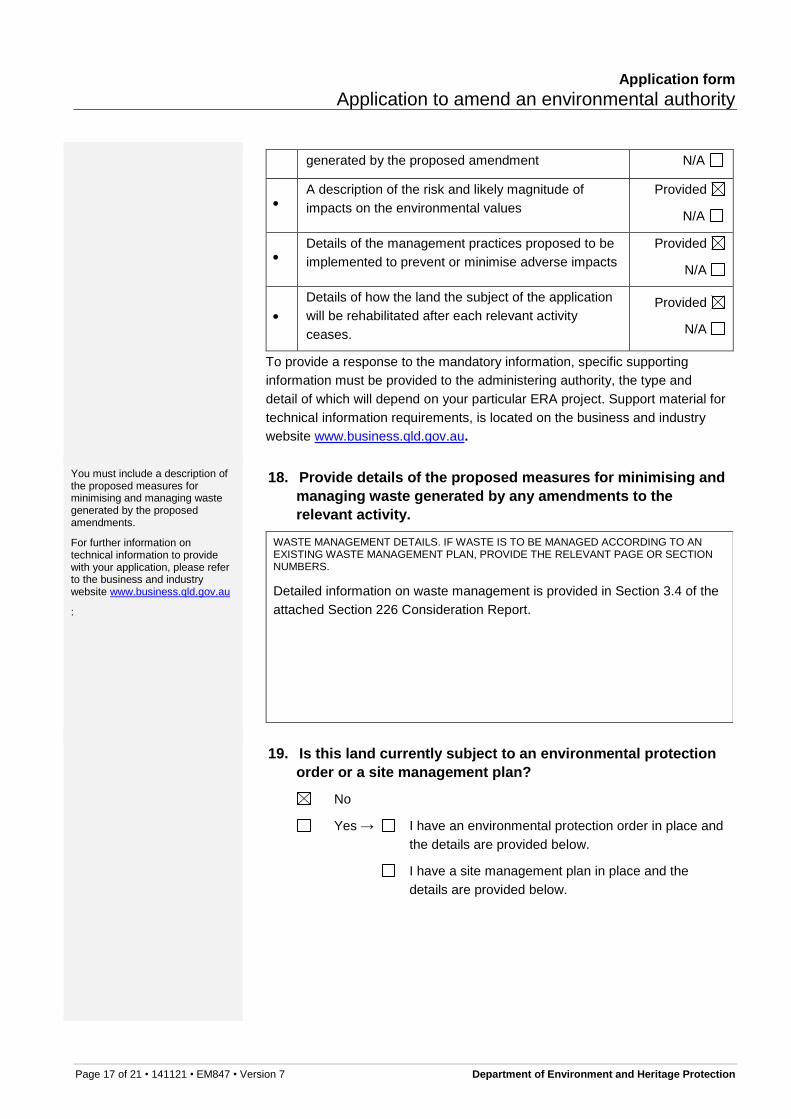
A description of the environmental values likely to be
affected by the proposed amendment
Provided
N/A
Details of any emissions or releases likely to be Provided
Application form
Application to amend an environmental authority
Page 17 of 21 • 141121 • EM847 • Version 7 Department of Environment and Heritage Protection
generated by the proposed amendment N/A
A description of the risk and likely magnitude of
impacts on the environmental values
Provided
N/A
Details of the management practices proposed to be
implemented to prevent or minimise adverse impacts
Provided
N/A
Details of how the land the subject of the application
will be rehabilitated after each relevant activity
ceases.
Provided
N/A
To provide a response to the mandatory information, specific supporting
information must be provided to the administering authority, the type and
detail of which will depend on your particular ERA project. Support material for
technical information requirements, is located on the business and industry
website www.business.qld.gov.au.
You must include a description of the proposed measures for minimising and managing waste generated by the proposed amendments.
For further information on technical information to provide with your application, please refer to the business and industry website www.business.qld.gov.au
:
18. Provide details of the proposed measures for minimising and
managing waste generated by any amendments to the
relevant activity.
WASTE MANAGEMENT DETAILS. IF WASTE IS TO BE MANAGED ACCORDING TO AN EXISTING WASTE MANAGEMENT PLAN, PROVIDE THE RELEVANT PAGE OR SECTION NUMBERS.
Detailed information on waste management is provided in Section 3.4 of the
attached Section 226 Consideration Report.
19. Is this land currently subject to an environmental protection
order or a site management plan?
No
Yes → I have an environmental protection order in place and
Page 18 of 21 • 141121 • EM847 • Version 7 Department of Environment and Heritage Protection
PROVIDE THE REFERENCE NUMBER AND BRIEF DETAILS
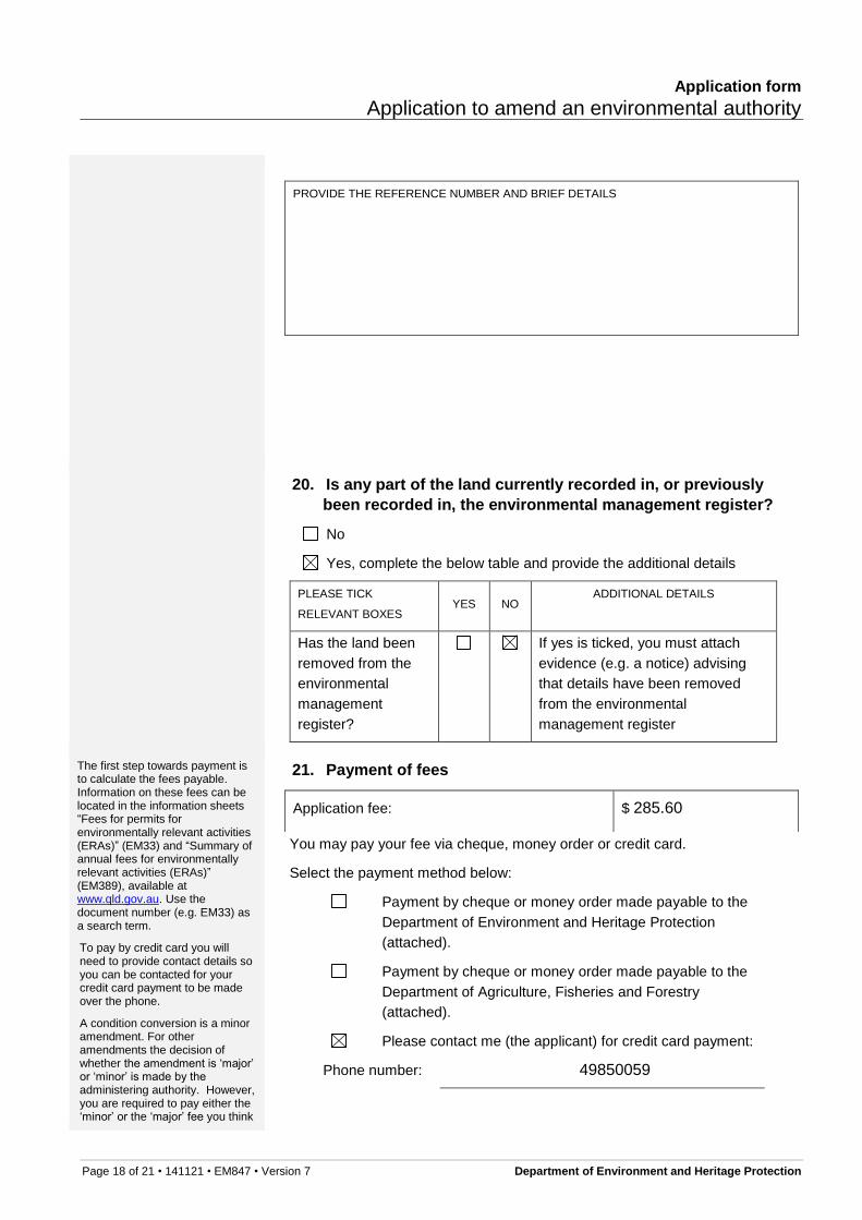
20. Is any part of the land currently recorded in, or previously
been recorded in, the environmental management register?
No
Yes, complete the below table and provide the additional details
PLEASE TICK
RELEVANT BOXES YES NO
ADDITIONAL DETAILS
Has the land been
removed from the
environmental
management
register?
If yes is ticked, you must attach
evidence (e.g. a notice) advising
that details have been removed
from the environmental
management register
The first step towards payment is to calculate the fees payable. Information on these fees can be located in the information sheets “Fees for permits for environmentally relevant activities (ERAs)” (EM33) and “Summary of annual fees for environmentally relevant activities (ERAs)” (EM389), available at www.qld.gov.au. Use the document number (e.g. EM33) as a search term.
To pay by credit card you will need to provide contact details so you can be contacted for your credit card payment to be made over the phone.
A condition conversion is a minor amendment. For other amendments the decision of whether the amendment is ‘major’ or ‘minor’ is made by the administering authority. However, you are required to pay either the ‘minor’ or the ‘major’ fee you think
21. Payment of fees
Application fee: $ 285.60
You may pay your fee via cheque, money order or credit card.
Select the payment method below:
Payment by cheque or money order made payable to the
Department of Environment and Heritage Protection
(attached).
Payment by cheque or money order made payable to the
Department of Agriculture, Fisheries and Forestry
(attached).
Please contact me (the applicant) for credit card payment:
Page 21 of 21 • 141121 • EM847 • Version 7 Department of Environment and Heritage Protection
Further information
The latest version of this publication and other publications referenced in this document can be found at www.qld.gov.au using the relevant publication number (EM847 for this form) as a search term.
Please submit your completed application to:
For a mining ERA where the proposed amendment impacts upon the
resource tenure:
Mining Registrar
Department of Natural Resources and Mines
DNRM have a list of office locations for mining registrars on their website
www.dnrm.qld.gov.au
For ERA 2, ERA 3 or ERA 4
Post: Senior Environmental Scientist Animal Industries Department of Agriculture, Fisheries and Forestry PO Box 102 TOOWOOMBA QLD 4350
Post: Permit and Licence Management Department of Environment and Heritage Protection GPO Box 2454 BRISBANE QLD 4001
Courier or hand delivery: Permit and Licence Management Department of Environment and Heritage Protection Level 3, 400 George Street BRISBANE QLD 4000 Business hours: 8:30am–4:30pm
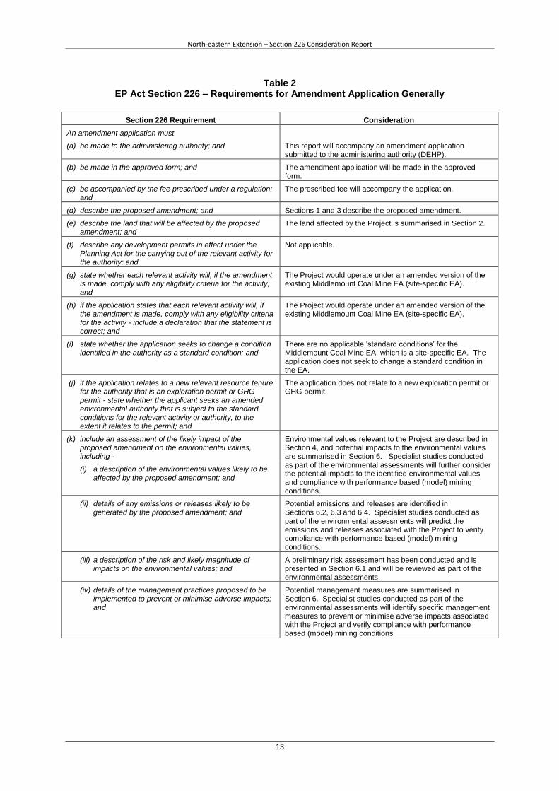
Table 2 EP Act Section 226 – Requirements for Amendment Application Generally
Section 226 Requirement Consideration
An amendment application must
(a) be made to the administering authority; and This report will accompany an amendment application submitted to the administering authority (DEHP).
(b) be made in the approved form; and The amendment application will be made in the approved form.
(c) be accompanied by the fee prescribed under a regulation; and
The prescribed fee will accompany the application.
(d) describe the proposed amendment; and Sections 1 and 3 describe the proposed amendment.
(e) describe the land that will be affected by the proposed amendment; and
The land affected by the Project is summarised in Section 2.
(f) describe any development permits in effect under the Planning Act for the carrying out of the relevant activity for the authority; and
Not applicable.
(g) state whether each relevant activity will, if the amendment is made, comply with any eligibility criteria for the activity; and
The Project would operate under an amended version of the existing Middlemount Coal Mine EA (site-specific EA).
(h) if the application states that each relevant activity will, if the amendment is made, comply with any eligibility criteria for the activity - include a declaration that the statement is correct; and
The Project would operate under an amended version of the existing Middlemount Coal Mine EA (site-specific EA).
(i) state whether the application seeks to change a condition identified in the authority as a standard condition; and
There are no applicable ‘standard conditions’ for the Middlemount Coal Mine EA, which is a site-specific EA. The application does not seek to change a standard condition in the EA.
(j) if the application relates to a new relevant resource tenure for the authority that is an exploration permit or GHG permit - state whether the applicant seeks an amended environmental authority that is subject to the standard conditions for the relevant activity or authority, to the extent it relates to the permit; and
The application does not relate to a new exploration permit or GHG permit.
(k) include an assessment of the likely impact of the proposed amendment on the environmental values, including -
Environmental values relevant to the Project are described in Section 4, and potential impacts to the environmental values are summarised in Section 6. Specialist studies conducted as part of the environmental assessments will further consider the potential impacts to the identified environmental values and compliance with performance based (model) mining conditions.
(i) a description of the environmental values likely to be affected by the proposed amendment; and
(ii) details of any emissions or releases likely to be generated by the proposed amendment; and
Potential emissions and releases are identified in Sections 6.2, 6.3 and 6.4. Specialist studies conducted as part of the environmental assessments will predict the emissions and releases associated with the Project to verify compliance with performance based (model) mining conditions.
(iii) a description of the risk and likely magnitude of impacts on the environmental values; and
A preliminary risk assessment has been conducted and is presented in Section 6.1 and will be reviewed as part of the environmental assessments.
(iv) details of the management practices proposed to be implemented to prevent or minimise adverse impacts; and
Potential management measures are summarised in Section 6. Specialist studies conducted as part of the environmental assessments will identify specific management measures to prevent or minimise adverse impacts associated with the Project and verify compliance with performance based (model) mining conditions.
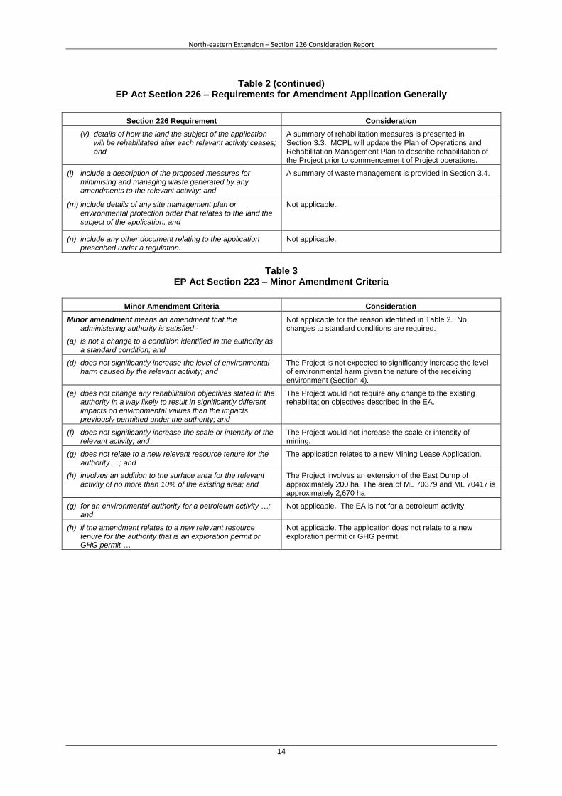
Table 2 (continued) EP Act Section 226 – Requirements for Amendment Application Generally
Section 226 Requirement Consideration
(v) details of how the land the subject of the application will be rehabilitated after each relevant activity ceases; and
A summary of rehabilitation measures is presented in Section 3.3. MCPL will update the Plan of Operations and Rehabilitation Management Plan to describe rehabilitation of the Project prior to commencement of Project operations.
(l) include a description of the proposed measures for minimising and managing waste generated by any amendments to the relevant activity; and
A summary of waste management is provided in Section 3.4.
(m) include details of any site management plan or environmental protection order that relates to the land the subject of the application; and
Not applicable.
(n) include any other document relating to the application prescribed under a regulation.
Not applicable.
Table 3
EP Act Section 223 – Minor Amendment Criteria
Minor Amendment Criteria Consideration
Minor amendment means an amendment that the administering authority is satisfied -
Not applicable for the reason identified in Table 2. No changes to standard conditions are required.
(a) is not a change to a condition identified in the authority as a standard condition; and
(d) does not significantly increase the level of environmental harm caused by the relevant activity; and
The Project is not expected to significantly increase the level of environmental harm given the nature of the receiving environment (Section 4).
(e) does not change any rehabilitation objectives stated in the authority in a way likely to result in significantly different impacts on environmental values than the impacts previously permitted under the authority; and
The Project would not require any change to the existing rehabilitation objectives described in the EA.
(f) does not significantly increase the scale or intensity of the relevant activity; and
The Project would not increase the scale or intensity of mining.
(g) does not relate to a new relevant resource tenure for the authority …; and
The application relates to a new Mining Lease Application.
(h) involves an addition to the surface area for the relevant activity of no more than 10% of the existing area; and
The Project involves an extension of the East Dump of approximately 200 ha. The area of ML 70379 and ML 70417 is approximately 2,670 ha
(g) for an environmental authority for a petroleum activity …; and
Not applicable. The EA is not for a petroleum activity.
(h) if the amendment relates to a new relevant resource tenure for the authority that is an exploration permit or GHG permit …
Not applicable. The application does not relate to a new exploration permit or GHG permit.
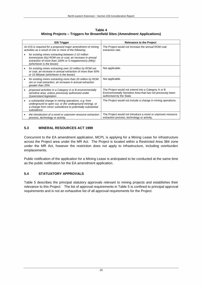
An EIS is required for a proposed major amendment of mining activities as a result of one or more of the following:
The Project would not increase the annual ROM coal extraction rate.
for existing mines extracting between 2-10 million tonnes/year (t/y) ROM ore or coal, an increase in annual extraction of more than 100% or 5 megatonnes/y (Mt/y) (whichever is the lesser)
for existing mines extracting over 10 million t/y ROM ore or coal, an increase in annual extraction of more than 50% or 10 Mt/year (whichever is the lesser)
Not applicable.
for existing mines extracting more than 20 million t/y ROM ore or coal extraction, an increase in annual extraction greater than 25%
Not applicable.
proposed activities in a Category A or B environmentally sensitive area, unless previously authorised under Queensland legislation
The Project would not extend into a Category A or B Environmentally Sensitive Area that has not previously been authorised by the State.
a substantial change in mining operations, e.g. from underground to open cut, or (for underground mining), or a change from minor subsidence to potentially substantial subsidence
The Project would not include a change in mining operations.
the introduction of a novel or unproven resource extraction process, technology or activity.
The Project would not introduce a novel or unproven resource extraction process, technology or activity.
5.3 MINERAL RESOURCES ACT 1989
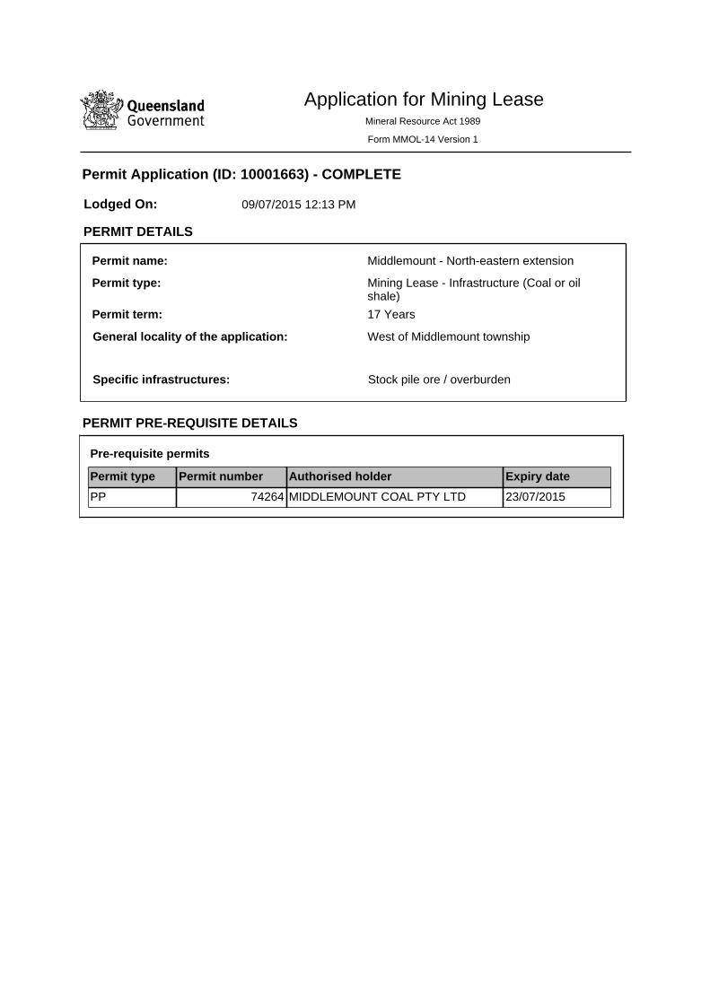
Concurrent to the EA amendment application, MCPL is applying for a Mining Lease for infrastructure
across the Project area under the MR Act. The Project is located within a Restricted Area 384 zone
under the MR Act, however the restriction does not apply to infrastructure, including overburden
emplacements.
Public notification of the application for a Mining Lease is anticipated to be conducted at the same time
as the public notification for the EA amendment application.
5.4 STATUATORY APPROVALS
Table 5 describes the principal statutory approvals relevant to mining projects and establishes their
relevance to this Project. The list of approval requirements in Table 5 is confined to principal approval
requirements and is not an exhaustive list of all approval requirements for the Project.
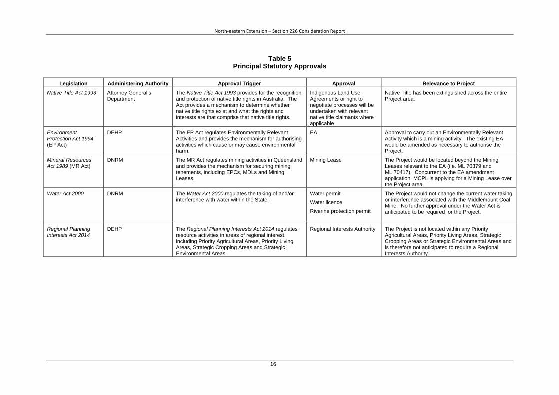
Legislation Administering Authority Approval Trigger Approval Relevance to Project
Native Title Act 1993 Attorney General’s Department
The Native Title Act 1993 provides for the recognition and protection of native title rights in Australia. The Act provides a mechanism to determine whether native title rights exist and what the rights and interests are that comprise that native title rights.
Indigenous Land Use Agreements or right to negotiate processes will be undertaken with relevant native title claimants where applicable
Native Title has been extinguished across the entire Project area.
Environment Protection Act 1994 (EP Act)
DEHP The EP Act regulates Environmentally Relevant Activities and provides the mechanism for authorising activities which cause or may cause environmental harm.
EA Approval to carry out an Environmentally Relevant Activity which is a mining activity. The existing EA would be amended as necessary to authorise the Project.
Mineral Resources Act 1989 (MR Act)
DNRM The MR Act regulates mining activities in Queensland and provides the mechanism for securing mining tenements, including EPCs, MDLs and Mining Leases.
Mining Lease The Project would be located beyond the Mining Leases relevant to the EA (i.e. ML 70379 and ML 70417). Concurrent to the EA amendment application, MCPL is applying for a Mining Lease over the Project area.
Water Act 2000 DNRM The Water Act 2000 regulates the taking of and/or interference with water within the State.
Water permit
Water licence
Riverine protection permit
The Project would not change the current water taking or interference associated with the Middlemount Coal Mine. No further approval under the Water Act is anticipated to be required for the Project.
Regional Planning Interests Act 2014
DEHP The Regional Planning Interests Act 2014 regulates resource activities in areas of regional interest, including Priority Agricultural Areas, Priority Living Areas, Strategic Cropping Areas and Strategic Environmental Areas.
Regional Interests Authority The Project is not located within any Priority Agricultural Areas, Priority Living Areas, Strategic Cropping Areas or Strategic Environmental Areas and is therefore not anticipated to require a Regional Interests Authority.
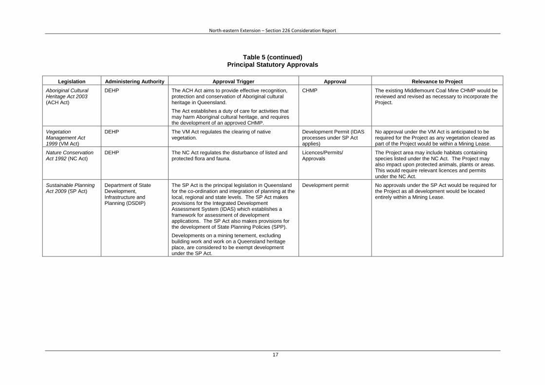
Legislation Administering Authority Approval Trigger Approval Relevance to Project
Aboriginal Cultural Heritage Act 2003 (ACH Act)
DEHP The ACH Act aims to provide effective recognition, protection and conservation of Aboriginal cultural heritage in Queensland.
The Act establishes a duty of care for activities that may harm Aboriginal cultural heritage, and requires the development of an approved CHMP.
CHMP The existing Middlemount Coal Mine CHMP would be reviewed and revised as necessary to incorporate the Project.
Vegetation Management Act 1999 (VM Act)
DEHP The VM Act regulates the clearing of native vegetation.
Development Permit (IDAS processes under SP Act applies)
No approval under the VM Act is anticipated to be required for the Project as any vegetation cleared as part of the Project would be within a Mining Lease.
Nature Conservation Act 1992 (NC Act)
DEHP The NC Act regulates the disturbance of listed and protected flora and fauna.
Licences/Permits/ Approvals
The Project area may include habitats containing species listed under the NC Act. The Project may also impact upon protected animals, plants or areas. This would require relevant licences and permits under the NC Act.
Sustainable Planning Act 2009 (SP Act)
Department of State Development, Infrastructure and Planning (DSDIP)
The SP Act is the principal legislation in Queensland for the co-ordination and integration of planning at the local, regional and state levels. The SP Act makes provisions for the Integrated Development Assessment System (IDAS) which establishes a framework for assessment of development applications. The SP Act also makes provisions for the development of State Planning Policies (SPP).
Developments on a mining tenement, excluding building work and work on a Queensland heritage place, are considered to be exempt development under the SP Act.
Development permit No approvals under the SP Act would be required for the Project as all development would be located entirely within a Mining Lease.
The Surface Water Assessment would identify the chemical and physical properties of surface waters
within the area that may be affected by the Project and assess the potential impacts of any discharges
(as determined by the revision of the site water balance model) on the quality and quantity of receiving
waters. It is anticipated that there would be no significant changes to the potential impacts to
receiving waters given Project water releases would be consistent with the existing EA (developed in
accordance with the Model Mining Conditions).
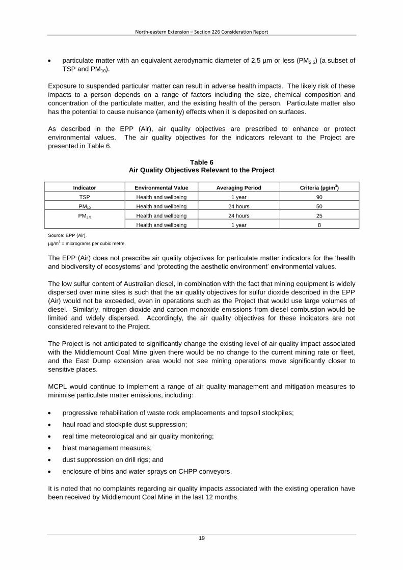
Consideration would be given to the DEHP Guideline Application Requirements for Activities with
Impacts to Water during the development of the Surface Water Assessment to assist in identifying
improvements to management and mitigation measures.
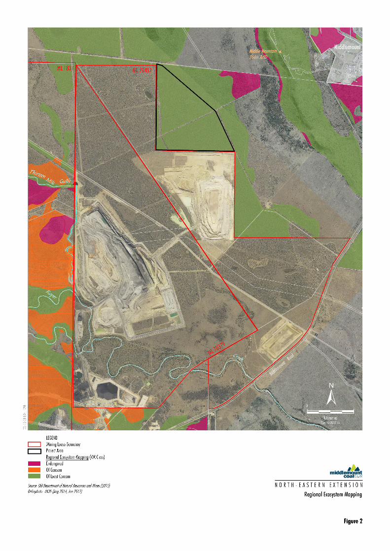
6.5 BIODIVERSITY Potential Impacts and Management Measures Vegetation and fauna habitat would be directly disturbed through clearing associated with the
associated with the Project. The Project will not disturb any Environmentally Sensitive Areas,
including endangered Regional Ecosystems. Based on the Queensland Herbarium RE mapping, the
Project would only disturb least concern vegetation.
The potential impacts to biodiversity would be minimised through avoidance, minimisation of
clearance, conducting clearance in accordance with the Species Management Program, mitigation
such as rehabilitation of the Project area in accordance with rehabilitation objectives (Section 3.3) and
through offset and compensatory measures to maintain or improve the biodiversity values of the
surrounding region in the medium to long-term.
Environmental Assessment
An environmental assessment of the potential impacts to biodiversity will be conducted by MCPL. A
Terrestrial Ecology Assessment would be conducted to assess the potential impacts to biodiversity
associated with the Project, including:
field validated RE mapping;
flora and fauna species, particularly threatened species listed under the NC Act;
Environmentally Sensitive Areas; and
Wetlands.
Direct impacts to the existing ecological environment would be assessed during each stage of the
Project, where relevant.
The assessment would describe proposed avoidance and mitigation measures to protect or enhance
natural values, and propose indicators to monitor potential impacts. In particular, measures would be
described to protect threatened or near-threatened species.
Consideration of biodiversity offset requirements would be included in the environmental assessment
in accordance with relevant Queensland Environmental Offsets Policy. The assessment will describe
the magnitude and duration of potential significant residual impacts and describe how the activity and
any associated offset would be staged.
Consideration would be given to the DEHP Guideline Application Requirements for Activities with
Impacts to Land during the development of the Terrestrial Ecology Assessment to identify potential
improvements to management and mitigation measures.
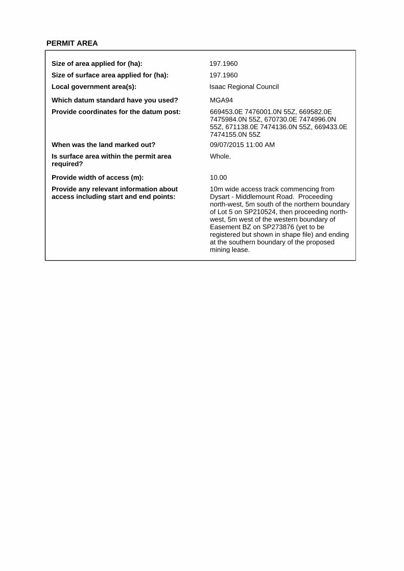
Provide coordinates for the datum post: 669453.0E 7476001.0N 55Z, 669582.0E 7475984.0N 55Z, 670730.0E 7474996.0N 55Z, 671138.0E 7474136.0N 55Z, 669433.0E 7474155.0N 55Z
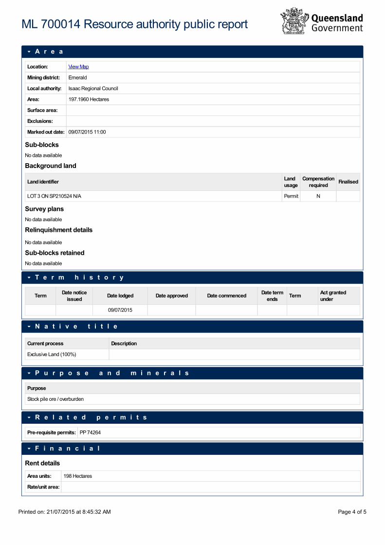
When was the land marked out? 09/07/2015 11:00 AM
Is surface area within the permit area required?
Whole.
Provide width of access (m): 10.00
Provide any relevant information about access including start and end points:
10m wide access track commencing from Dysart - Middlemount Road. Proceeding north-west, 5m south of the northern boundary of Lot 5 on SP210524, then proceeding north-west, 5m west of the western boundary of Easement BZ on SP273876 (yet to be registered but shown in shape file) and ending at the southern boundary of the proposed mining lease.
Size of area applied for (ha): 197.1960
Size of surface area applied for (ha): 197.1960
Local government area(s): Isaac Regional Council
LAND INFORMATION DETAILS
Does this application involve the surrender of a granted permit in favour of whole or part of this application?
No
Is there any restricted land associated with this permit application?
No
Is the lease area within the surface of reserve?
No
Are you making this application jointly with the holder of the ATP permit?
No
Are you making this application with the consent of that holder?
No
Is the land applied for situated within an area of a greenhouse gas (GHG) permit?
No
Overlapping permits
Permit type Permit number Authorised holder Expiry date
ATP 1103 CH4 PTY LTD 31/12/2018
Land details
Description Proposed usage
Current usage Compensation required?
Lot 3 on plan SP210524 - Freehold Par N/A Permit Industrial No
NATIVE TITLE
Native title process: Exclusive Land (100%)
I confirm that when a full assessment is completed, if native title must be addressed, a native title process will be required and advertising fees will be requested by the department:
Yes
ENVIRONMENTAL AUTHORITY
The environmental authority application is: Application for amendment of an environmental authority
Suitable registered operator details
Holder Suitable Operator Status Registered No.
RIBFIELD PTY LTD Registered 347796
MIDDLEMOUNT COAL PTY LTD Registered 601484
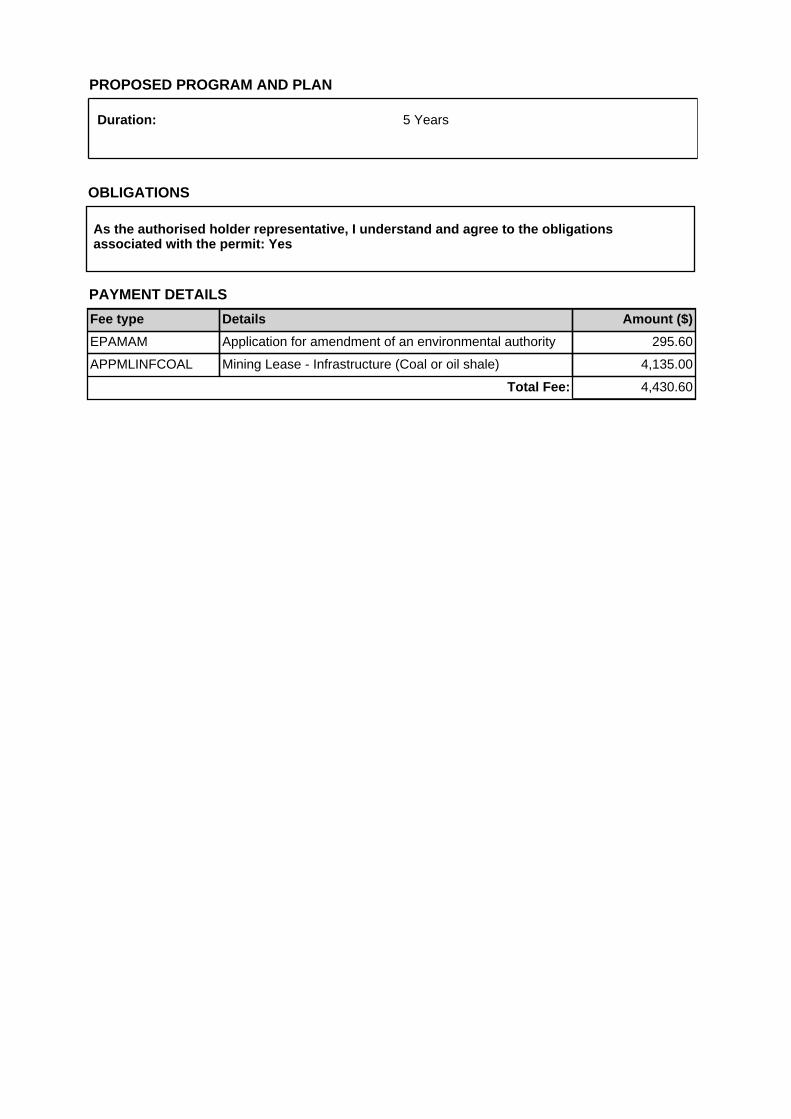
PROPOSED PROGRAM AND PLAN
Duration: 5 Years
As the authorised holder representative, I understand and agree to the obligations associated with the permit: Yes
OBLIGATIONS
PAYMENT DETAILS
Fee type Details Amount ($)
EPAMAM Application for amendment of an environmental authority 295.60
APPMLINFCOAL Mining Lease - Infrastructure (Coal or oil shale) 4,135.00
The Queensland Government supports and encourages the dissemination and exchange of its information. The copyright in this publication is licensed under a Creative Commons Attribution 3.0 Australia (CC BY) licence.
Under this licence you are free, without having to seek our permission, to use this publication in accordance with the licence terms.
You must keep intact the copyright notice and attribute the State of as the source of the publication.
For more information on this licence, visit http://creativecommons.org/licenses/by/3.0/au/deed.en
The information contained herein is subject to change without notice. The Queensland Government shall not be liable for technical or other errors or omissions contained herein. The reader/user accepts all risks and responsibility for losses, damages, costs and other consequences resulting directly or indirectly from using this information.